weathering, erosion and depositmrges.com/news/assets/06 surface properties key r.pdfweathering,...
TRANSCRIPT
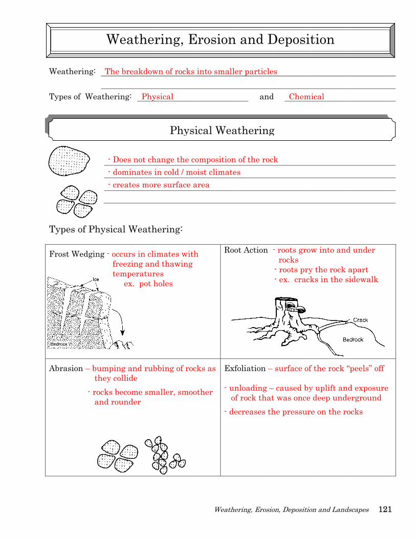
Weathe Types o Types Frost W
Abrasio
ring: The
f Weather
- D- d- cr
of Physic
Wedging - oc fr te
n – bumpin they c - rocks b and ro
W
e breakdow
ring: Phy
Does not chdominates ireates mor
cal Weath
ccurs in clireezing andemperatur ex. pot h
ng and rubollide become smounder
Weather
wn of rocks
ysical
hange the cin cold / more surface a
hering:
imates withd thawing es
holes
bbing of roc
aller, smoo
ring, E
Phys
Weath
into small
compositionoist climatearea
h
Ro
cks as
other
Ex - u o- d
Erosion
ical Wea
hering, Erosio
ler particle
and
n of the roces
oot Action
xfoliation –
unloading –of rock thatdecreases th
n and D
athering
ion, Depositio
es
d Chemi
ck
- roots grow rocks - roots pry- ex. crack
– surface of
– caused byt was once he pressure
Deposit
g
on and Lands
ical
w into and
y the rock aks in the si
f the rock “p
y uplift anddeep undee on the ro
tion
scapes 121
d under
apart idewalk
peels” off
d exposure erground ocks
1
122
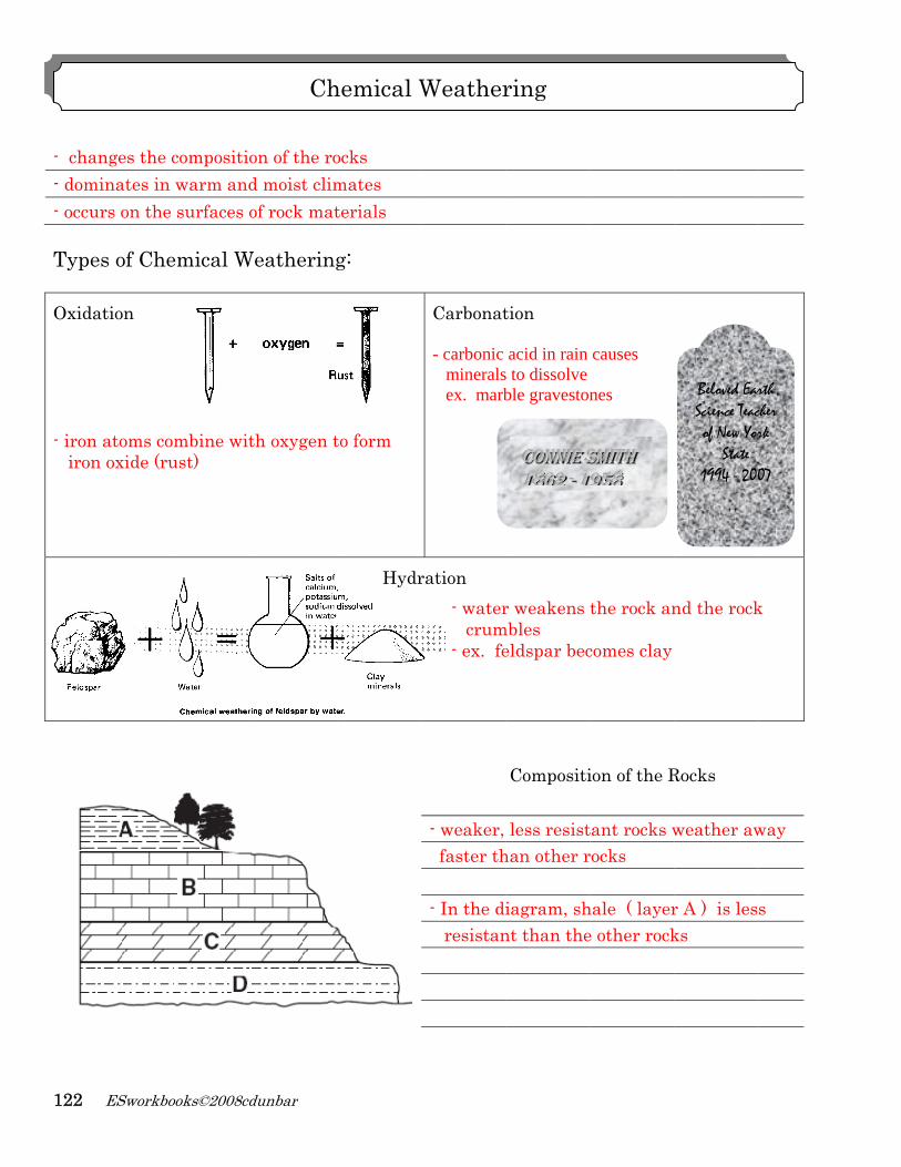
- ch- dom- occ Typ Oxid - iro iro
ESworkbo
hanges the minates incurs on the
pes of Che
dation
on atoms coon oxide (ru
books©2008cd
composition warm ande surfaces o
emical W
ombine witust)
dunbar
on of the rod moist climof rock mat
Weathering
th oxygen t
Ch
ocks mates terials
g:
to form
Hydr
hemical W
Carbonat - carbonic minerals ex. marb
ration - water crum - ex. fe
- weaker, faster th - In the di resistan
Weather
tion
acid in rain s to dissolve ble graveston
r weakens mbles eldspar bec
Compositi
less resisthan other r
iagram, shnt than the
CCCOOONNNNNNIIIEEE SSS111888666222 --- 11199
ring
causes nes
the rock an
comes clay
ion of the R
tant rocks wrocks
hale ( layere other rock
SSSMMMIIITTTHHH 1999555888
nd the rock
Rocks
weather aw
r A ) is lesks
Beloved EarScience Teacof New Yor
State 1994 - 200
k
way
s
rth cher rk
07
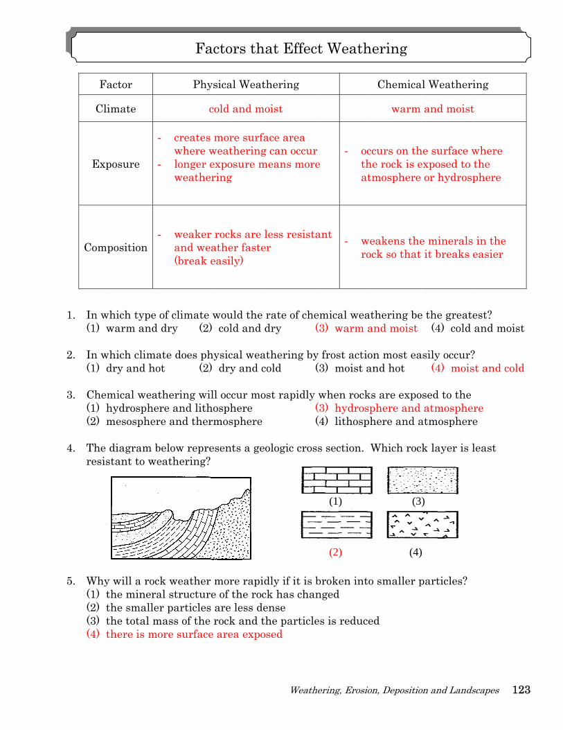
F
Cl
Ex
Com
1. In w
(1) 2. In w
(1) 3. Che
(1) (2)
4. The
resi
5. Why
(1) (2) (3) (4)
Factor
limate
xposure
mposition
which type warm and
which climadry and ho
emical weathydrosphemesospher
e diagram bstant to we
y will a rocthe minerathe smallethe total mthere is mo
Phy
c
- creates where w
- longer eweathe
- weakerand we(break
of climate dry (2)
ate does phot (2)
thering wiere and lithre and ther
below repreeathering?
ck weatheral structurer particlesmass of the ore surface
Fa
ysical Weat
cold and m
more surfweatheringexposure mring
r rocks are ather fasteeasily)
would the ) cold and
hysical wea) dry and c
ll occur mohospherermosphere
esents a ge
r more rapie of the roc
s are less derock and t
e area expo
actors th
Weath
thering
moist
face area g can occurmeans more
less resistaer
rate of chedry (
athering bycold (
ost rapidly ((
eologic cros
idly if it is bck has chanense the particleosed
hat Effec
hering, Erosio
r e
- octhat
ant - wro
emical wea(3) warm a
y frost actio(3) moist a
when rock(3) hydros(4) lithosp
ss section.
broken intonged
es is reduce
ct Weath
(1)
(2)
ion, Depositio
Chemica
warm
ccurs on thhe rock is etmosphere
weakens theock so that
athering beand moist
on most eaand hot
ks are exposphere and phere and a
Which roc
o smaller p
ed
hering
(3
(4)
on and Lands
al Weatheri
and moist
he surface wexposed to t
or hydrosp
e minerals it breaks e
e the greate(4) cold
asily occur?(4) mois
osed to the atmospher
atmosphere
k layer is l
particles?
)
)
scapes 123
ing
t
where the phere
in the easier
est? and moist
? st and cold
re e
least
3
124 ESworkbooks©2008cdunbar
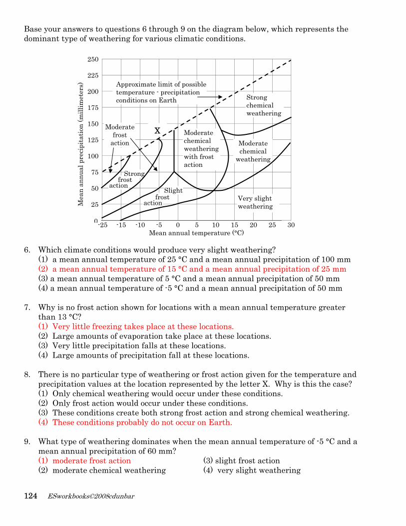
Base your answers to questions 6 through 9 on the diagram below, which represents the dominant type of weathering for various climatic conditions.
250
225
200
175
150
125
100
75
50
25
-25 -15 -10 -5 0 5 10 15 20 25 30
Mean annual temperature (°C) 6. Which climate conditions would produce very slight weathering?
(1) a mean annual temperature of 25 °C and a mean annual precipitation of 100 mm (2) a mean annual temperature of 15 °C and a mean annual precipitation of 25 mm (3) a mean annual temperature of 5 °C and a mean annual precipitation of 50 mm (4) a mean annual temperature of -5 °C and a mean annual precipitation of 50 mm
7. Why is no frost action shown for locations with a mean annual temperature greater than 13 °C? (1) Very little freezing takes place at these locations. (2) Large amounts of evaporation take place at these locations. (3) Very little precipitation falls at these locations. (4) Large amounts of precipitation fall at these locations.
8. There is no particular type of weathering or frost action given for the temperature and precipitation values at the location represented by the letter X. Why is this the case? (1) Only chemical weathering would occur under these conditions. (2) Only frost action would occur under these conditions. (3) These conditions create both strong frost action and strong chemical weathering. (4) These conditions probably do not occur on Earth.
9. What type of weathering dominates when the mean annual temperature of -5 °C and a mean annual precipitation of 60 mm? (1) moderate frost action (3) slight frost action (2) moderate chemical weathering (4) very slight weathering
X
action frost
Strong
action frost
Slight
Approximate limit of possible temperature - precipitation conditions on Earth Strong
chemical weathering
Very slight weathering
Moderate chemical weathering with frost action
Moderate chemical
weathering
Moderate frost
action
Mea
n an
nual
pre
cipi
tatio
n (m
illim
eter
s)
0
Weathering, Erosion, Deposition and Landscapes 125
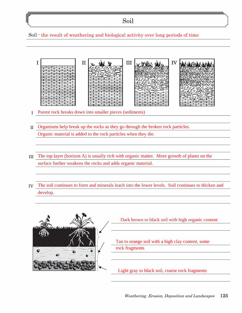
Soil - the result of weathering and biological activity over long periods of time
I Parent rock breaks down into smaller pieces (sediments)
II Organisms help break up the rocks as they go through the broken rock particles.
Organic material is added to the rock particles when they die.
III The top layer (horizon A) is usually rich with organic matter. More growth of plants on the
surface further weakens the rocks and adds organic material.
IV The soil continues to form and minerals leach into the lower levels. Soil continues to thicken and
develop.
Dark brown to black soil with high organic content
Tan to orange soil with a high clay content, some rock fragments
Light gray to black soil, coarse rock fragments
Soil
I II III IV
126
Resi
Tran 1.
2.
3.
4.
5.
6.
ESworkbo
idual soil
nsported so
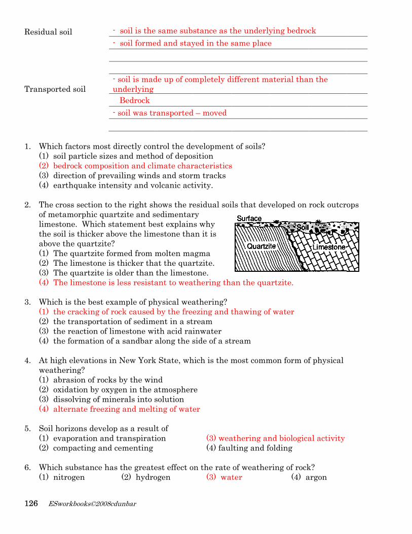
Which fact(1) soil pa(2) bedroc(3) directi(4) earthq The cross sof metamolimestone.the soil is above the (1) The qu(2) The lim(3) The qu(4) The lim
Which is th(1) the cra(2) the tra(3) the rea(4) the for At high eleweatherin(1) abrasio(2) oxidati(3) dissolv(4) alterna
Soil horizo(1) evapor(2) compa Which sub(1) nitroge
books©2008cd
- -
oil - u -
tors most darticle sizesck composition of prevaquake inten
section to torphic quar Which stathicker aboquartzite?
uartzite formestone is uartzite is omestone is
he best exaacking of roansportatioaction of limrmation of
evations ing? on of rocksion by oxygving of minate freezin
ons developration and cting and c
bstance hasen
dunbar
soil is the soil forme
soil is madunderlying
Bedrock soil was tr
directly cons and methtion and cliailing windnsity and v
the right shrtzite and satement beove the lim
rmed from thicker tholder than less resist
ample of phock causedon of sedimmestone wa sandbar
n New York
s by the wingen in the a
nerals into g and melt
p as a resultranspiratcementing
s the great(2) hydro
e same subed and stay
de up of co
ransported
ntrol the dehod of depoimate char
ds and storvolcanic act
hows the rsedimentarest explain
mestone tha
molten maat the quarthe limestant to wea
hysical wead by the frement in a st
ith acid raalong the s
k State, wh
nd atmosphersolutionting of wat
lt of tion
est effect oogen
stance as tyed in the s
mpletely d
d – moved
evelopmentsition racteristicsrm trackstivity.
esidual soiry
ns why an it is
agma rtzite. tone. athering th
athering?ezing and t
tream inwater side of a st
hich is the m
re
er
(3) wea(4) faul
on the rate (3) wa
the underlysame place
different ma
t of soils?
s
ils that dev
an the qua
thawing of
tream
most comm
athering anlting and fo
of weatherater
ying bedroce
aterial tha
veloped on
artzite.
f water
mon form of
nd biologicafolding
ring of rock(4) a
ck
an the
rock outcro
f physical
al activity
k? argon
ops
Weathering, Erosion, Deposition and Landscapes 127
7. Equal masses of two identical rock samples. Sample A is one large block, while sample B was cut into four smaller blocks of equal size. If subjected to the same environmental conditions, sample B will weather more quickly than sample A. The best explanation for this is that the
Sample A Sample B
(1) volume of Sample B is greater than that of Sample A (2) surface area of Sample B is greater than that of Sample A (3) density of Sample A is greater than that of Sample B (4) hardness of Sample A is greater than that of Sample B
8. Which change would cause the topsoil in New York State to increase in thickness?
(1) an increase in slope (3) an increase in biologic activity (2) a decrease in rainfall (4) a decrease in air temperature
9. Which change in the climate of New York State would most likely cause the greatest
increase in chemical weathering of local bedrock? (1) lower temperature in the winter (2) lower humidity in the winter (3) higher atmospheric pressure in the summer (4) greater precipitation in the summer
10. Humus, which is formed by the decay of plant and animal matter, is important for the
formation of most (1) surface bedrock (2) minerals (3) sediment (4) soils
11. Which factor has the least effect on the weathering of a rock?
(1) climatic conditions (2) composition of the rock (3) exposure of the rock to the atmosphere (4) the number of fossils found in the rock
12. Solid bedrock is changed to soil primarily by the process of
(1) erosion (2) weathering (3) infiltration (4) transpiration 13. Water is the major agent of chemical weathering because water
(1) cools the surrounding air when it evaporates (2) dissolves many of the minerals that make up rocks (3) has density of about one gram per cubic centimeter (4) has the highest specific heat of all common earth materials
14. How does chemical weathering help to increase the amount of physical weathering?
(1) by creating more surface area (3) by exfoliation (2) by weakening the rock (4) frost wedging
128 ESworkbooks©2008cdunbar
Erosion: - the transportation of weathered rock materials
Agents of Erosion
Streams (running water), glaciers (moving ice), wave action, wind, mass movement (gravity)
Deposition: - the dropping out of weathered rock materials 1. The composition of sediments on Earth’s surface usually is quite different from the
composition of the underlying bedrock. This observation suggests that most (1) bedrock is formed from sediments (3) bedrock is resistant to weathering (2) sediments are residual (4) sediments have been transported
2. On Earth’s surface, transported materials are more common than residual materials. This condition is mainly the result of (1) recrystallization (2) erosion (3) folding (4) subduction
3. Most of the surface materials in New York State can be classified as
(1) igneous rock (3) metamorphic rocks (2) coastal plain deposits (4) transported soils
4. Granite pebbles are found on the surface in a certain area where only sandstone bedrock is exposed. Which is the most likely explanation for the presence of these pebbles? (1) The granite pebbles were transported to the area from a different region. (2) Some of the sandstone has been changed into granite. (3) The granite pebbles were formed by weathering of the exposed sandstone bedrock. (4) Ground water tends to form granite pebbles within layers of sandstone rock.
5. By which processes are rocks broken up and moved to different locations?
(1) evaporation and condensation (3) burial and cementation (2) weathering and erosion (4) compaction and transportation
6. Transported rock materials are more common than residual rock materials in the soils
of New York State. Which statement best explains this observation? (1) Solid rock must be transported to break. (2) Weathering changes transported rock materials more easily than residual rock
materials. (3) Most rock materials are moved by some agent of erosion at some time in their
history. (4) Residual rock materials form only from bedrock that is difficult to change into soil.
Erosion & Deposition
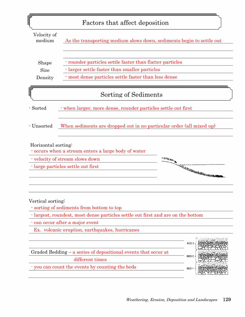
Weathering, Erosion, Deposition and Landscapes 129
Velocity of medium As the transporting medium slows down, sediments begin to settle out
Shape - rounder particles settle faster than flatter particles Size - larger settle faster than smaller particles
Density - most dense particles settle faster than less dense - Sorted - when larger, more dense, rounder particles settle out first
- Unsorted When sediments are dropped out in no particular order (all mixed up) Horizontal sorting: - occurs when a stream enters a large body of water - velocity of stream slows down - large particles settle out first
Vertical sorting: - sorting of sediments from bottom to top - largest, roundest, most dense particles settle out first and are on the bottom - can occur after a major event Ex. volcanic eruption, earthquakes, hurricanes Graded Bedding – a series of depositional events that occur at different times - you can count the events by counting the beds
Factors that affect deposition
Sorting of Sediments
130
Bastwo
Thrwerwatto ddata
1.
ESworkbo
e your anslaboratory
Particle
ee differene released er. The lenrop from pa table 1.
Partic15 m10 m5 m
During Acpotential e(1) decrea
books©2008cd
wers to quy activities
Diame
15 mm Al (a
10 mm Al (a
5 mm Al (al
Activitnt particles
in a plastingth of timoint A to p
Data Tabcle Size T
mm Al mm Al
m Al
tivity 1, asenergy of thases
dunbar
estions 1 tbelow. Th
Pa
eter
aluminum)
aluminum)
luminum)
ty 1 of differen
c tube filleme each parpoint B is sh
ble 1 ime of Settlin
3.2 sec 5.4 sec 7.2 sec
s the 10 mihe particle
(2) incre
hrough 4 ohe particles
rticles Use
Density
2.7 g/cm3
2.7 g/cm3
2.7 g/cm3 .
nt sizes ed with rticle took hown in
ng
illimeter al. ases
on the diags used in th
ed in Activi
Particle
DiffeplaceliquidThe tquickthe pcombdata partiomitt
Combina
A
B
luminum p
(3) rem
grams belowhese activit
ites
Diame
15 mm Fe
15 mm Pb
15 mm Al (a
erent combied in a tubed and allowtube was thkly turned particles to binations oftable 2. T
ical sortingted intenti
Da
ation Part
11511515
particles dr
mains the s
w and descties are des
eter
e (iron)
b (lead)
aluminum)
Activity 2 inations ofe filled witwed to fall hen stoppeupside dowsettle. Th
f particles The diagramg in data taally.
ata Table 2
ticles Mixed
5 mm Al 0 mm Al
5 mm Al 5 mm Al 5 mm Fe 5 mm Pb
rops from A
same
criptions ofscribed bel
Density
7.9 g/cm3
11.4 g/cm3
2.7 g/cm 3 .
f particles wh a thick to the bott
ered and wn, allowinhe differentare shown
m of the able 2 has b
DiagramSortin
A to B, the
f the low.
were
tom.
ng t
n in
been
m of g
2. TheonceupsWhiExp
- p
3. In A
metreprSiz
Le Top
4. A th
alumof th
Particle Shape Round Oval Flat
(
e diagrams e they settlide down, tich diagram
plain your rarticles set
(1)
Activity 2, wtals, labeleresents theze and shapad is most p
(1)
hird activitminum parhis third ac
Settling Time
3.2 sec 5.1 sec 6.7 sec
1)
below reprled to the bthe aluminm below rereasoning. ttle out wit
when the td “Combine sorting thpe are the dense and
ty, similar irticles withctivity?
Particle Shape
Round Oval Flat (
resent whebottom of tnum particlepresents th
Shape ath the larg
(2)
tube is turnnation B,” ahat is mostsame.
d is on the b
(2)
in setup toh identical
Settling Time
5.1 sec 3.2 sec 6.7 sec
(2)
Weath
ere each of the tube. Inles , labelehe sorting and densityest on the
ned upsideare allowedt likely to o
bottom. Al
o Activity 1masses. W
ParticleShape
Round Oval Flat
hering, Erosio
the spheren Activity
ed “Combinthat is mo
y is the sambottom
(3)
down, thed to settle. occur? 4
luminum is
(3)
1 was done Which table
e Settling Time
5.1 sec 5.1 sec 5.1 sec
(3)
ion, Depositio
es would m2, when th
nation A,” ast likely to
me (same s
e particles oWhich dia
4 Exp
s the least
using flat,e shows the
ParticlShape
Round Oval Flat
on and Lands
most likely bhe tube is tuare allowedo occur? substance)
(4
of three difagram belowplain your r
dense and
(4
oval, and e most like
e e Settl
d 653
(4)
scapes 131
be found urned
d to settle. 2
4)
fferent w reasoning.
d is on the
4)
round ely results
ling Time
6.7 sec 5.1 sec 3.2 sec
1
132
1.
((((
2. (
3.
4.
W(
5.
6.
G
ESworkbo
The best e(1) deep re(2) sedimen(3) tilted ro(4) faulted Which ero
(1) gravity
Which mov(1) sedime(2) boulde
The diagradebris.
What was th(1) gravity
Glacial mov(1) Earth’s The primary(1) solar en
Gravity
books©2008cd
- all ag- exam cliffs- witho
vidence thsidual soil nt observedock layers orock layer
sional forcey
vement of eents flowiners carried
am below s
e primary fo
vement is caurotation
y force responergy
dunbar
gents of eromples of eros and mass out other er
at erosion observed o
d at the boobserved os observed
e acts alon(2) runn
earth mateng in a rive
by a glacie
shows the s
orce that cau(2) movin
used primari(2) gravity
onsible for th(2) magne
osion are dosion by gra
movementrosional fo
has taken on a hill sidttom of a cn a mount
d on a plate
ne to producing water
erials is grar
er
sequence of
sed this landng ice
ily by y
he flow of wetic fields
riven by gravity alonet down steerces, rocks
place woulde cliff ain
eau
ce avalanc(3) win
avity NOT(3) sno(4) mo
f events lea
dslide? (3) prev
(3) eros
water in a stre(3) win
ravity e include laep slopes s are usuall
ld be provi
hes and lands
T the main ow tumblinoisture evap
ading to th
vailing wind
sion
eam is nd
andslides d
ly jagged a
ided by
ndslides? (4) s
force? ng in an avporating fr
he depositio
ds (4) st
(4) g
(4) g
dropping off
and rough
sea waves
valanche rom an ocea
on of lands
tream discha
global winds
gravity
ff
an
slide
arge
Weathering, Erosion, Deposition and Landscapes 133
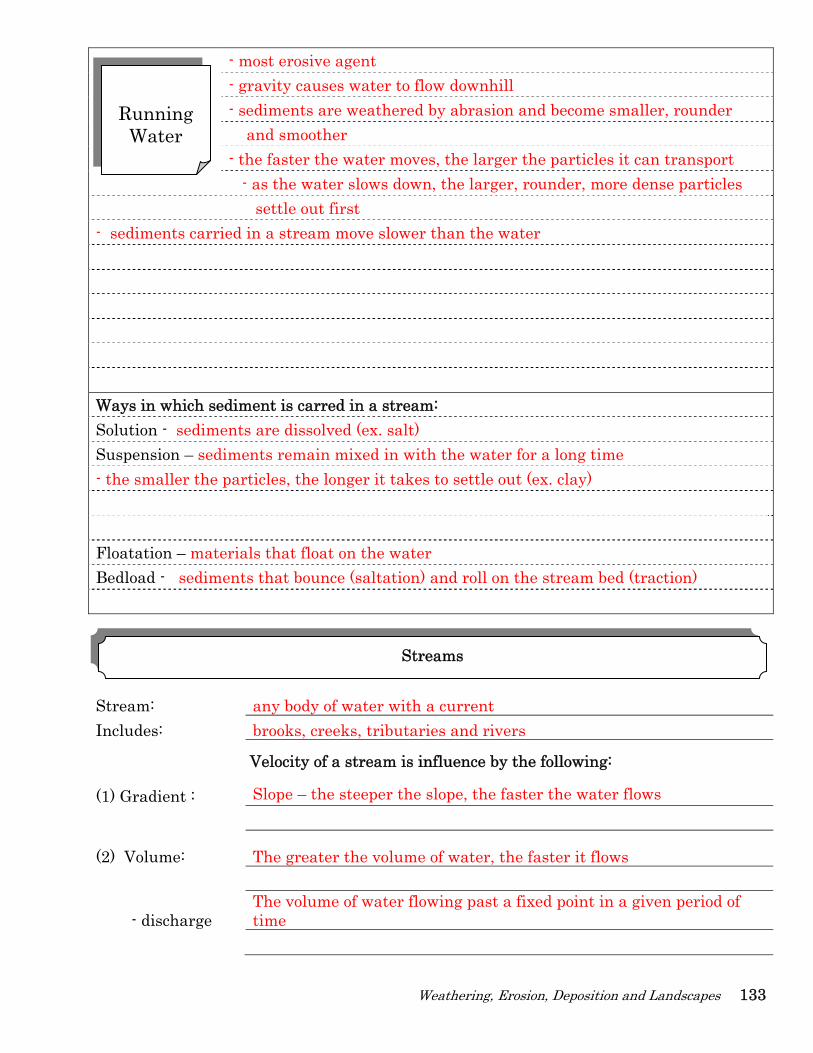
- most erosive agent - gravity causes water to flow downhill - sediments are weathered by abrasion and become smaller, rounder and smoother - the faster the water moves, the larger the particles it can transport - as the water slows down, the larger, rounder, more dense particles
settle out first - sediments carried in a stream move slower than the water Ways in which sediment is carred in a stream: Solution - sediments are dissolved (ex. salt) Suspension – sediments remain mixed in with the water for a long time - the smaller the particles, the longer it takes to settle out (ex. clay) Floatation – materials that float on the water Bedload - sediments that bounce (saltation) and roll on the stream bed (traction) Stream: any body of water with a current Includes: brooks, creeks, tributaries and rivers
Velocity of a stream is influence by the following:
(1) Gradient : Slope – the steeper the slope, the faster the water flows
(2) Volume: The greater the volume of water, the faster it flows
- discharge The volume of water flowing past a fixed point in a given period of time
Streams
Running
Water
134 ESworkbooks©2008cdunbar
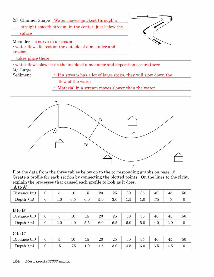
(3) Channel Shape Water moves quickest through a
straight smooth stream, in the center just below the suface
Meander – a curve in a stream - water flows fastest on the outside of a meander and erosion takes place there - water flows slowest on the inside of a meander and deposition occurs there (4) Large Sediment - If a stream has a lot of large rocks, they will slow down the flow of the water - Material in a stream moves slower than the water Plot the data from the three tables below on to the corresponding graphs on page 15. Create a profile for each section by connecting the plotted points. On the lines to the right, explain the processes that caused each profile to look as it does. A to A’ Distance (m) 0 5 10 15 20 25 30 35 40 45 50 Depth (m) 0 4.0 6.5 6.0 5.0 3.0 1.5 1.0 .75 .5 0
B to B’ Distance (m) 0 5 10 15 20 25 30 35 40 45 50 Depth (m) 0 2.0 4.0 5.5 6.0 6.5 6.0 5.0 4.0 2.0 0
C to C’ Distance (m) 0 5 10 15 20 25 30 35 40 45 50 Depth (m) 0 .5 .75 1.0 1.5 3.0 4.5 6.0 6.5 4.5 0
A
A’
B
B’
C’
C
Weathering, Erosion, Deposition and Landscapes 135
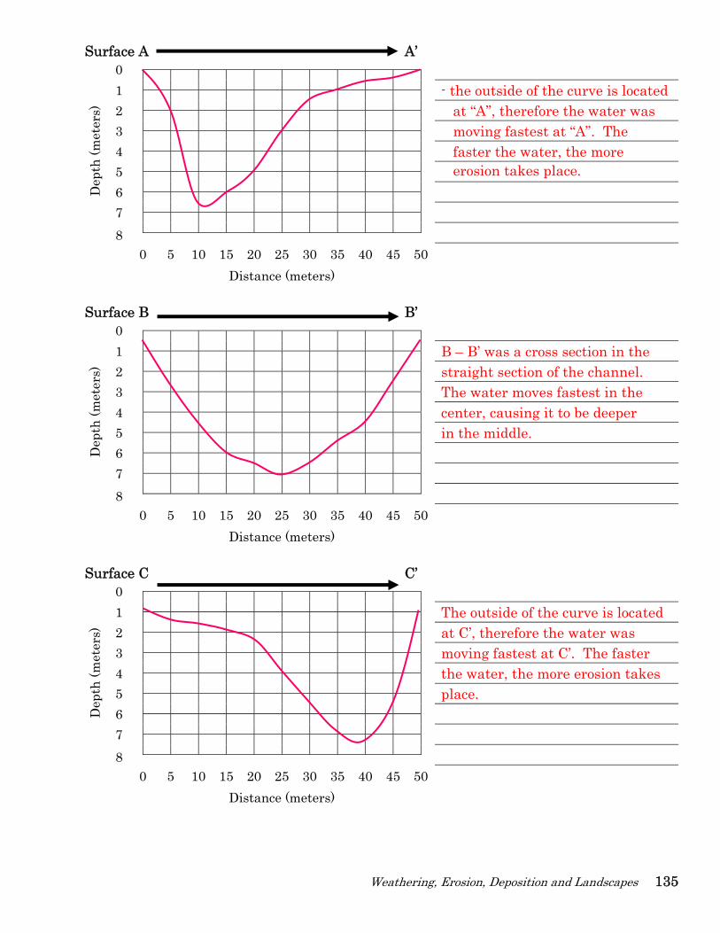
Surface A A’
Dep
th (m
eter
s)
0 1 - the outside of the curve is located 2 at “A”, therefore the water was 3 moving fastest at “A”. The 4 faster the water, the more 5 erosion takes place. 6 7 8
0 5 10 15 20 25 30 35 40 45 50 Distance (meters)
Surface B B’
Dep
th (m
eter
s)
0 1 B – B’ was a cross section in the 2 straight section of the channel. 3 The water moves fastest in the 4 center, causing it to be deeper 5 in the middle. 6 7 8
0 5 10 15 20 25 30 35 40 45 50 Distance (meters)
Surface C C’
Dep
th (m
eter
s)
0 1 The outside of the curve is located 2 at C’, therefore the water was 3 moving fastest at C’. The faster 4 the water, the more erosion takes 5 place. 6 7 8
0 5 10 15 20 25 30 35 40 45 50 Distance (meters)
136 ESworkbooks©2008cdunbar
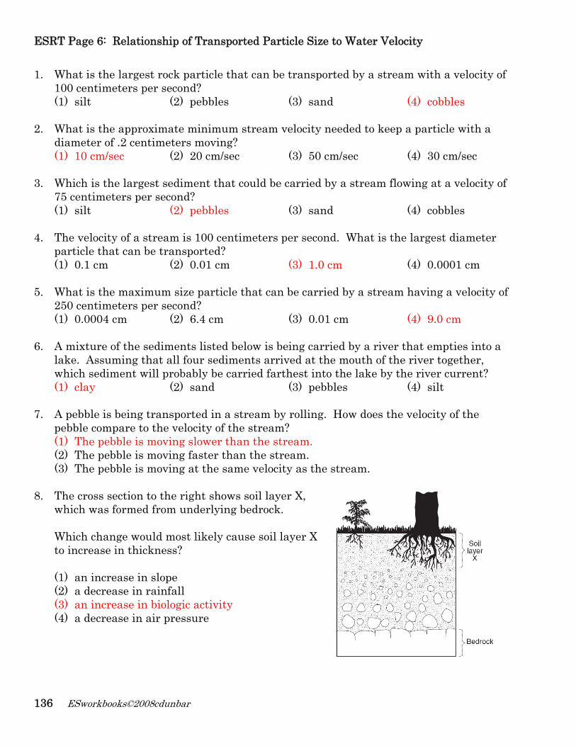
ESRT Page 6: Relationship of Transported Particle Size to Water Velocity 1. What is the largest rock particle that can be transported by a stream with a velocity of
100 centimeters per second? (1) silt (2) pebbles (3) sand (4) cobbles
2. What is the approximate minimum stream velocity needed to keep a particle with a diameter of .2 centimeters moving? (1) 10 cm/sec (2) 20 cm/sec (3) 50 cm/sec (4) 30 cm/sec
3. Which is the largest sediment that could be carried by a stream flowing at a velocity of 75 centimeters per second? (1) silt (2) pebbles (3) sand (4) cobbles
4. The velocity of a stream is 100 centimeters per second. What is the largest diameter particle that can be transported? (1) 0.1 cm (2) 0.01 cm (3) 1.0 cm (4) 0.0001 cm
5. What is the maximum size particle that can be carried by a stream having a velocity of
250 centimeters per second? (1) 0.0004 cm (2) 6.4 cm (3) 0.01 cm (4) 9.0 cm
6. A mixture of the sediments listed below is being carried by a river that empties into a
lake. Assuming that all four sediments arrived at the mouth of the river together, which sediment will probably be carried farthest into the lake by the river current? (1) clay (2) sand (3) pebbles (4) silt
7. A pebble is being transported in a stream by rolling. How does the velocity of the
pebble compare to the velocity of the stream? (1) The pebble is moving slower than the stream. (2) The pebble is moving faster than the stream. (3) The pebble is moving at the same velocity as the stream.
8. The cross section to the right shows soil layer X,
which was formed from underlying bedrock. Which change would most likely cause soil layer X to increase in thickness? (1) an increase in slope (2) a decrease in rainfall (3) an increase in biologic activity (4) a decrease in air pressure
Weathering, Erosion, Deposition and Landscapes 137
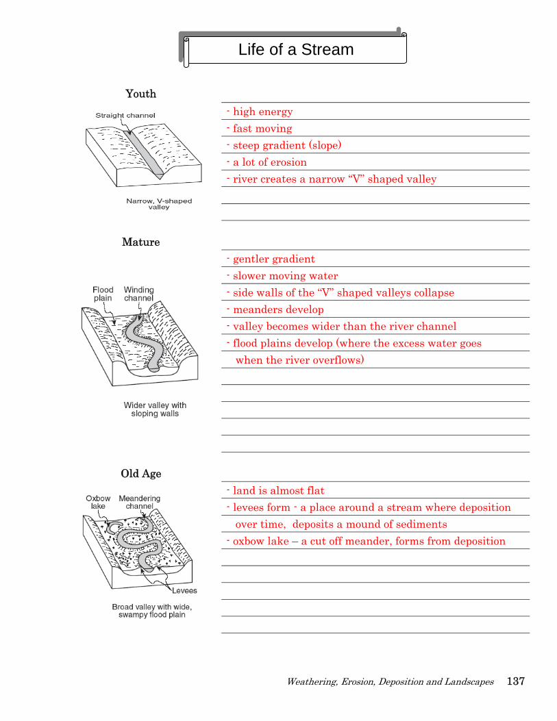
Youth
- high energy - fast moving - steep gradient (slope) - a lot of erosion - river creates a narrow “V” shaped valley
Mature
- gentler gradient - slower moving water - side walls of the “V” shaped valleys collapse - meanders develop - valley becomes wider than the river channel - flood plains develop (where the excess water goes when the river overflows)
Old Age
- land is almost flat - levees form - a place around a stream where deposition over time, deposits a mound of sediments - oxbow lake – a cut off meander, forms from deposition
Life of a Stream
138 ESworkbooks©2008cdunbar
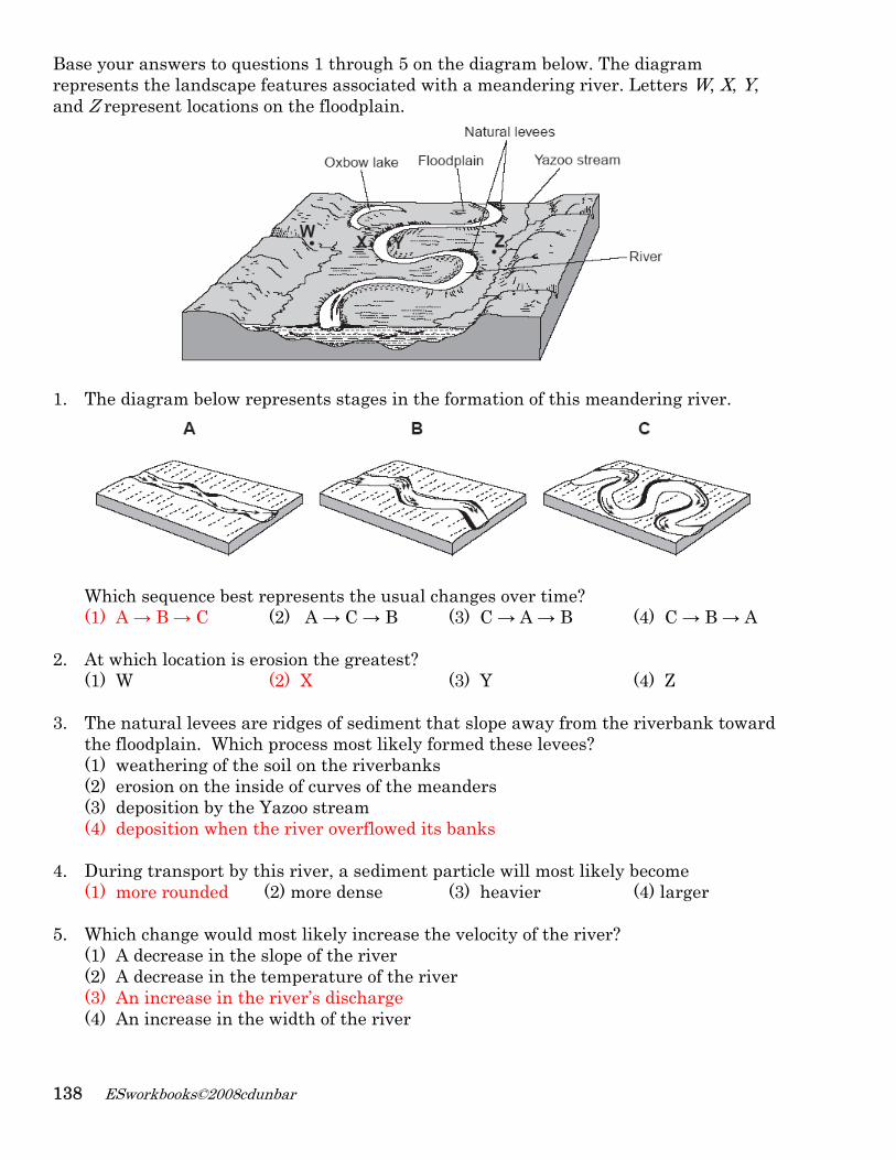
Base your answers to questions 1 through 5 on the diagram below. The diagram represents the landscape features associated with a meandering river. Letters W, X, Y, and Z represent locations on the floodplain.
1. The diagram below represents stages in the formation of this meandering river.
Which sequence best represents the usual changes over time? (1) A → B → C (2) A → C → B (3) C → A → B (4) C → B → A
2. At which location is erosion the greatest?
(1) W (2) X (3) Y (4) Z
3. The natural levees are ridges of sediment that slope away from the riverbank toward the floodplain. Which process most likely formed these levees? (1) weathering of the soil on the riverbanks (2) erosion on the inside of curves of the meanders (3) deposition by the Yazoo stream (4) deposition when the river overflowed its banks
4. During transport by this river, a sediment particle will most likely become
(1) more rounded (2) more dense (3) heavier (4) larger
5. Which change would most likely increase the velocity of the river? (1) A decrease in the slope of the river (2) A decrease in the temperature of the river (3) An increase in the river’s discharge (4) An increase in the width of the river
Weathering, Erosion, Deposition and Landscapes 139
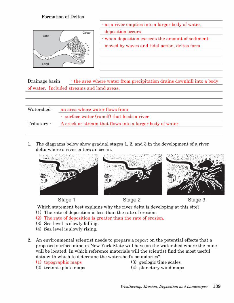
Formation of Deltas
- as a river empties into a larger body of water, deposition occurs - when deposition exceeds the amount of sediment moved by waves and tidal action, deltas form
Drainage basin - the area where water from precipitation drains downhill into a body of water. Included streams and land areas.
Watershed - an area where water flows from - surface water (runoff) that feeds a river Tributary - A creek or stream that flows into a larger body of water
1. The diagrams below show gradual stages 1, 2, and 3 in the development of a river delta where a river enters an ocean.
Which statement best explains why the river delta is developing at this site? (1) The rate of deposition is less than the rate of erosion. (2) The rate of deposition is greater than the rate of erosion. (3) Sea level is slowly falling. (4) Sea level is slowly rising.
2. An environmental scientist needs to prepare a report on the potential effects that a proposed surface mine in New York State will have on the watershed where the mine will be located. In which reference materials will the scientist find the most useful data with which to determine the watershed’s boundaries? (1) topographic maps (3) geologic time scales (2) tectonic plate maps (4) planetary wind maps
140 ESworkbooks©2008cdunbar
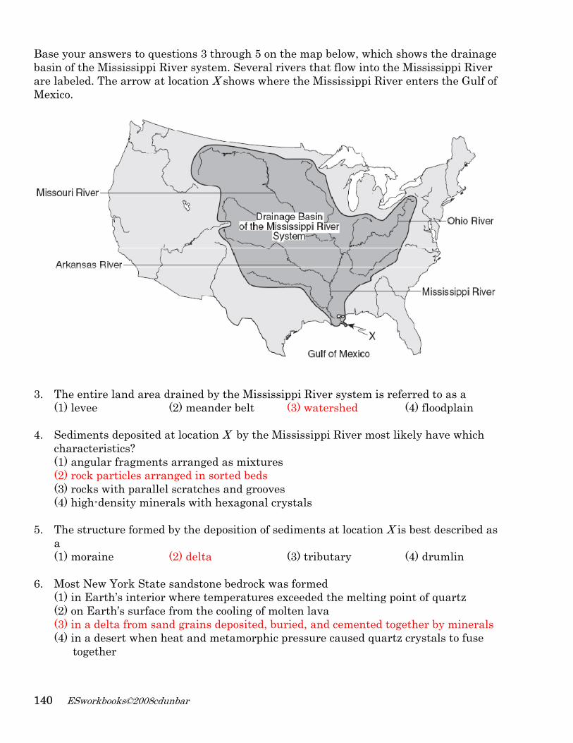
Base your answers to questions 3 through 5 on the map below, which shows the drainage basin of the Mississippi River system. Several rivers that flow into the Mississippi River are labeled. The arrow at location X shows where the Mississippi River enters the Gulf of Mexico.
3. The entire land area drained by the Mississippi River system is referred to as a
(1) levee (2) meander belt (3) watershed (4) floodplain
4. Sediments deposited at location X by the Mississippi River most likely have which characteristics? (1) angular fragments arranged as mixtures (2) rock particles arranged in sorted beds (3) rocks with parallel scratches and grooves (4) high-density minerals with hexagonal crystals
5. The structure formed by the deposition of sediments at location X is best described as
a (1) moraine (2) delta (3) tributary (4) drumlin
6. Most New York State sandstone bedrock was formed (1) in Earth’s interior where temperatures exceeded the melting point of quartz (2) on Earth’s surface from the cooling of molten lava (3) in a delta from sand grains deposited, buried, and cemented together by minerals (4) in a desert when heat and metamorphic pressure caused quartz crystals to fuse together
Weathering, Erosion, Deposition and Landscapes 141
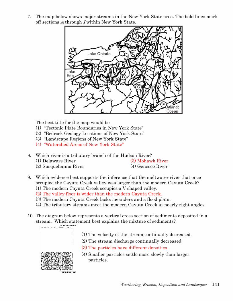
7. The map below shows major streams in the New York State area. The bold lines mark off sections A through I within New York State.
The best title for the map would be (1) “Tectonic Plate Boundaries in New York State” (2) “Bedrock Geology Locations of New York State” (3) “Landscape Regions of New York State” (4) “Watershed Areas of New York State”
8. Which river is a tributary branch of the Hudson River? (1) Delaware River (3) Mohawk River (2) Susquehanna River (4) Genesee River
9. Which evidence best supports the inference that the meltwater river that once occupied the Cayuta Creek valley was larger than the modern Cayuta Creek? (1) The modern Cayuta Creek occupies a V shaped valley. (2) The valley floor is wider than the modern Cayuta Creek. (3) The modern Cayuta Creek lacks meanders and a flood plain. (4) The tributary streams meet the modern Cayuta Creek at nearly right angles.
10. The diagram below represents a vertical cross section of sediments deposited in a stream. Which statement best explains the mixture of sediments?
(1) The velocity of the stream continually decreased. (2) The stream discharge continually decreased. (3) The particles have different densities. (4) Smaller particles settle more slowly than larger
particles.
142 ESworkbooks©2008cdunbar
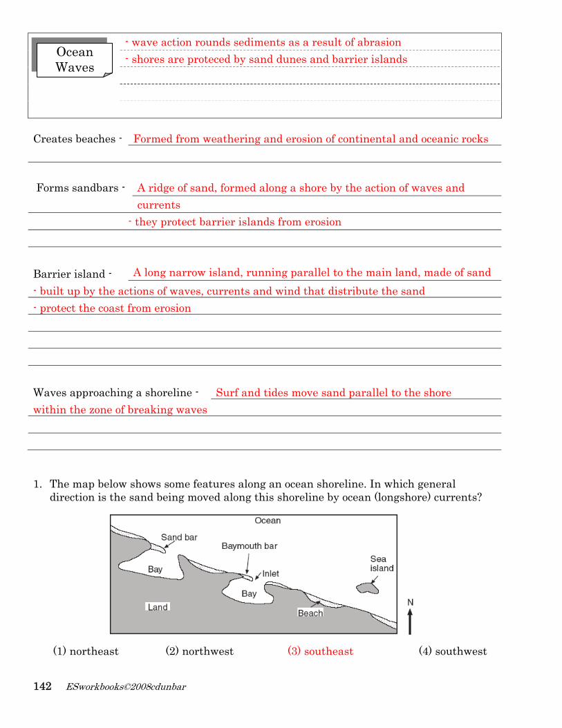
- wave action rounds sediments as a result of abrasion - shores are proteced by sand dunes and barrier islands
Creates beaches - Formed from weathering and erosion of continental and oceanic rocks Forms sandbars - A ridge of sand, formed along a shore by the action of waves and currents - they protect barrier islands from erosion Barrier island - A long narrow island, running parallel to the main land, made of sand - built up by the actions of waves, currents and wind that distribute the sand - protect the coast from erosion Waves approaching a shoreline - Surf and tides move sand parallel to the shore within the zone of breaking waves 1. The map below shows some features along an ocean shoreline. In which general
direction is the sand being moved along this shoreline by ocean (longshore) currents?
(1) northeast (2) northwest (3) southeast (4) southwest
Ocean Waves
Weathering, Erosion, Deposition and Landscapes 143
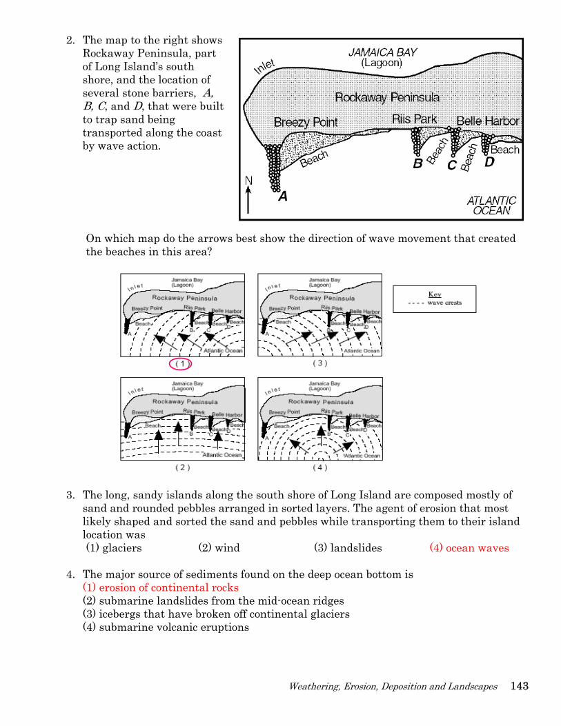
2. The map to the right shows Rockaway Peninsula, part of Long Island’s south shore, and the location of several stone barriers, A, B, C, and D, that were built to trap sand being transported along the coast by wave action.
On which map do the arrows best show the direction of wave movement that created the beaches in this area?
3. The long, sandy islands along the south shore of Long Island are composed mostly of
sand and rounded pebbles arranged in sorted layers. The agent of erosion that most likely shaped and sorted the sand and pebbles while transporting them to their island location was (1) glaciers (2) wind (3) landslides (4) ocean waves
4. The major source of sediments found on the deep ocean bottom is (1) erosion of continental rocks (2) submarine landslides from the mid-ocean ridges (3) icebergs that have broken off continental glaciers (4) submarine volcanic eruptions
144 ESworkbooks©2008cdunbar
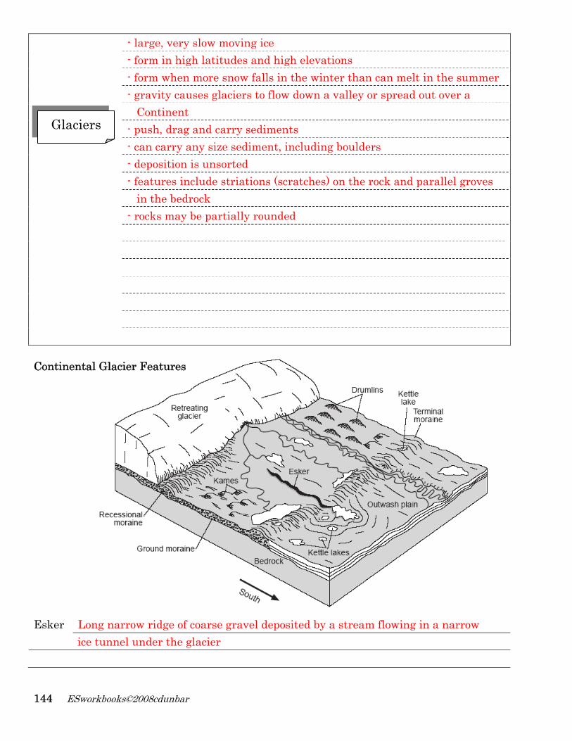
- large, very slow moving ice - form in high latitudes and high elevations - form when more snow falls in the winter than can melt in the summer - gravity causes glaciers to flow down a valley or spread out over a Continent - push, drag and carry sediments - can carry any size sediment, including boulders - deposition is unsorted - features include striations (scratches) on the rock and parallel groves in the bedrock - rocks may be partially rounded
Continental Glacier Features
Esker Long narrow ridge of coarse gravel deposited by a stream flowing in a narrow ice tunnel under the glacier
Glaciers
Weathering, Erosion, Deposition and Landscapes 145
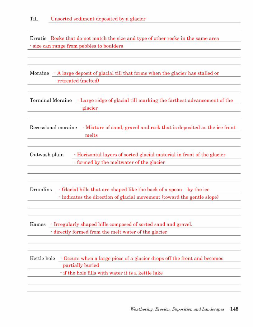
Till Unsorted sediment deposited by a glacier
Erratic Rocks that do not match the size and type of other rocks in the same area - size can range from pebbles to boulders
Moraine - A large deposit of glacial till that forms when the glacier has stalled or retreated (melted)
Terminal Moraine - Large ridge of glacial till marking the farthest advancement of the glacier
Recessional moraine - Mixture of sand, gravel and rock that is deposited as the ice front melts
Outwash plain - Horizontal layers of sorted glacial material in front of the glacier - formed by the meltwater of the glacier
Drumlins - Glacial hills that are shaped like the back of a spoon – by the ice - indicates the direction of glacial movement (toward the gentle slope)
Kames - Irregularly shaped hills composed of sorted sand and gravel. - directly formed from the melt water of the glacier
Kettle hole - Occurs when a large piece of a glacier drops off the front and becomes partially buried - if the hole fills with water it is a kettle lake
146 ESworkbooks©2008cdunbar
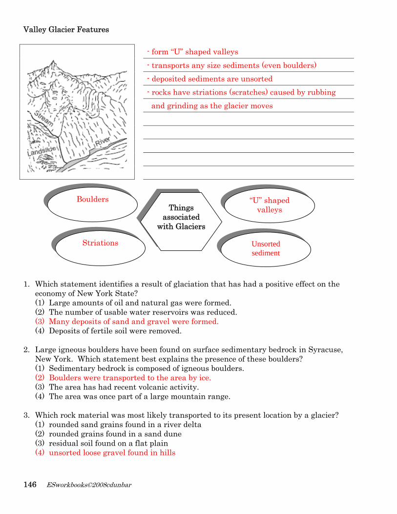
Valley Glacier Features
- form “U” shaped valleys - transports any size sediments (even boulders) - deposited sediments are unsorted - rocks have striations (scratches) caused by rubbing and grinding as the glacier moves
1. Which statement identifies a result of glaciation that has had a positive effect on the
economy of New York State? (1) Large amounts of oil and natural gas were formed. (2) The number of usable water reservoirs was reduced. (3) Many deposits of sand and gravel were formed. (4) Deposits of fertile soil were removed.
2. Large igneous boulders have been found on surface sedimentary bedrock in Syracuse, New York. Which statement best explains the presence of these boulders? (1) Sedimentary bedrock is composed of igneous boulders. (2) Boulders were transported to the area by ice. (3) The area has had recent volcanic activity. (4) The area was once part of a large mountain range.
3. Which rock material was most likely transported to its present location by a glacier? (1) rounded sand grains found in a river delta (2) rounded grains found in a sand dune (3) residual soil found on a flat plain (4) unsorted loose gravel found in hills
Things associated
with Glaciers
“U” shaped valleys
Boulders
Striations Unsorted sediment
Weathering, Erosion, Deposition and Landscapes 147
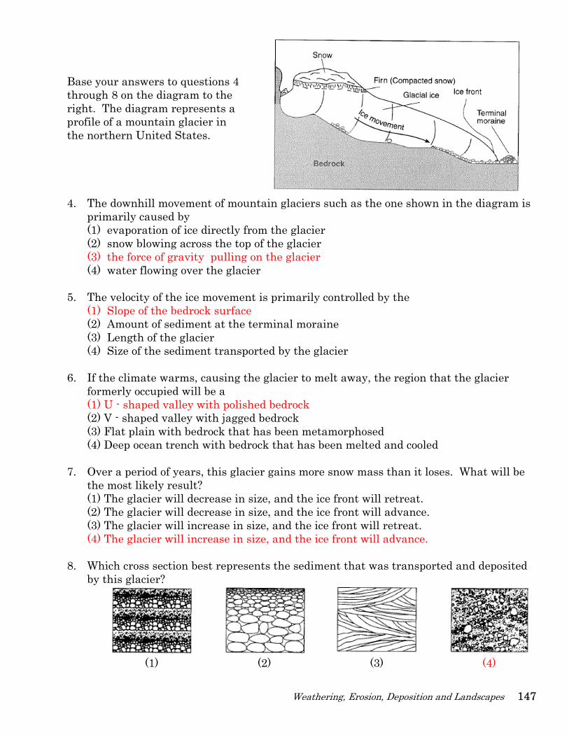
Base your answers to questions 4 through 8 on the diagram to the right. The diagram represents a profile of a mountain glacier in the northern United States.
4. The downhill movement of mountain glaciers such as the one shown in the diagram is primarily caused by (1) evaporation of ice directly from the glacier (2) snow blowing across the top of the glacier (3) the force of gravity pulling on the glacier (4) water flowing over the glacier
5. The velocity of the ice movement is primarily controlled by the
(1) Slope of the bedrock surface (2) Amount of sediment at the terminal moraine (3) Length of the glacier (4) Size of the sediment transported by the glacier
6. If the climate warms, causing the glacier to melt away, the region that the glacier
formerly occupied will be a (1) U - shaped valley with polished bedrock (2) V - shaped valley with jagged bedrock (3) Flat plain with bedrock that has been metamorphosed (4) Deep ocean trench with bedrock that has been melted and cooled
7. Over a period of years, this glacier gains more snow mass than it loses. What will be
the most likely result? (1) The glacier will decrease in size, and the ice front will retreat. (2) The glacier will decrease in size, and the ice front will advance. (3) The glacier will increase in size, and the ice front will retreat. (4) The glacier will increase in size, and the ice front will advance.
8. Which cross section best represents the sediment that was transported and deposited
by this glacier?
(1) (2) (3) (4)
148 ESworkbooks©2008cdunbar
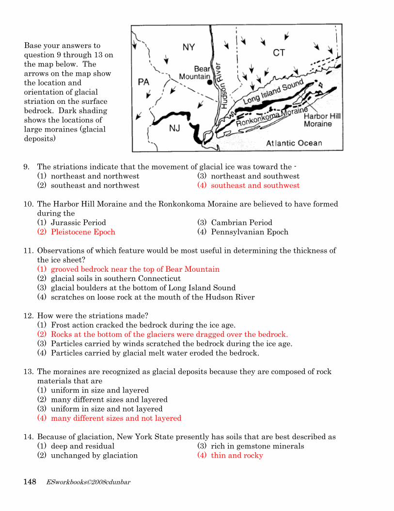
Base your answers to question 9 through 13 on the map below. The arrows on the map show the location and orientation of glacial striation on the surface bedrock. Dark shading shows the locations of large moraines (glacial deposits)
9. The striations indicate that the movement of glacial ice was toward the -
(1) northeast and northwest (3) northeast and southwest (2) southeast and northwest (4) southeast and southwest
10. The Harbor Hill Moraine and the Ronkonkoma Moraine are believed to have formed during the (1) Jurassic Period (3) Cambrian Period (2) Pleistocene Epoch (4) Pennsylvanian Epoch
11. Observations of which feature would be most useful in determining the thickness of the ice sheet? (1) grooved bedrock near the top of Bear Mountain (2) glacial soils in southern Connecticut (3) glacial boulders at the bottom of Long Island Sound (4) scratches on loose rock at the mouth of the Hudson River
12. How were the striations made? (1) Frost action cracked the bedrock during the ice age. (2) Rocks at the bottom of the glaciers were dragged over the bedrock. (3) Particles carried by winds scratched the bedrock during the ice age. (4) Particles carried by glacial melt water eroded the bedrock.
13. The moraines are recognized as glacial deposits because they are composed of rock materials that are (1) uniform in size and layered (2) many different sizes and layered (3) uniform in size and not layered (4) many different sizes and not layered
14. Because of glaciation, New York State presently has soils that are best described as (1) deep and residual (3) rich in gemstone minerals (2) unchanged by glaciation (4) thin and rocky
Weathering, Erosion, Deposition and Landscapes 149
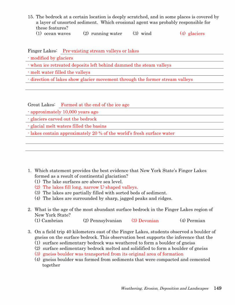
15. The bedrock at a certain location is deeply scratched, and in some places is covered by a layer of unsorted sediment. Which erosional agent was probably responsible for these features? (1) ocean waves (2) running water (3) wind (4) glaciers
Finger Lakes: Pre-existing stream valleys or lakes - modified by glaciers - when ice retreated deposits left behind dammed the steam valleys - melt water filled the valleys - direction of lakes show glacier movement through the former stream valleys Great Lakes: Formed at the end of the ice age - approximately 10,000 years ago - glaciers carved out the bedrock - glacial melt waters filled the basins - lakes contain approximately 20 % of the world’s fresh surface water 1. Which statement provides the best evidence that New York State’s Finger Lakes
formed as a result of continental glaciation? (1) The lake surfaces are above sea level. (2) The lakes fill long, narrow U-shaped valleys. (3) The lakes are partially filled with sorted beds of sediment. (4) The lakes are surrounded by sharp, jagged peaks and ridges.
2. What is the age of the most abundant surface bedrock in the Finger Lakes region of New York State? (1) Cambrian (2) Pennsylvanian (3) Devonian (4) Permian
3. On a field trip 40 kilometers east of the Finger Lakes, students observed a boulder of gneiss on the surface bedrock. This observation best supports the inference that the (1) surface sedimentary bedrock was weathered to form a boulder of gneiss (2) surface sedimentary bedrock melted and solidified to form a boulder of gneiss (3) gneiss boulder was transported from its original area of formation (4) gneiss boulder was formed from sediments that were compacted and cemented together
150 ESworkbooks©2008cdunbar
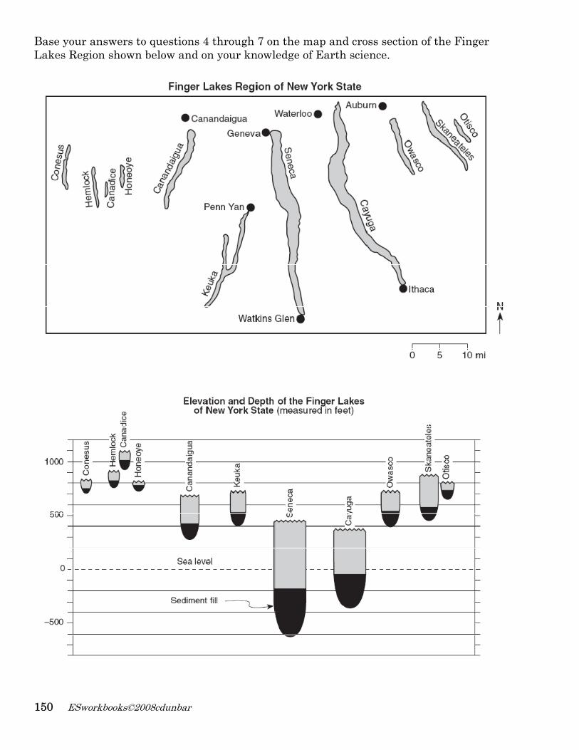
Base your answers to questions 4 through 7 on the map and cross section of the Finger Lakes Region shown below and on your knowledge of Earth science.
Weathering, Erosion, Deposition and Landscapes 151
4. According to the cross section, how thick from top to bottom is the sediment fill in Seneca Lake? 425 ft
5. State one possible explanation for the north-south orientation of the Finger Lakes.
- they represent the direction in which the glaciers advanced
6. During some winters, a few of the Finger Lakes remain unfrozen even though the land
around the lakes is frozen. Explain how the specific heat of water can cause these lakes to remain unfrozen. Water has a high specific heat and it takes longer to freeze
7. Identify two processes that normally occur to form the type of surface bedrock found
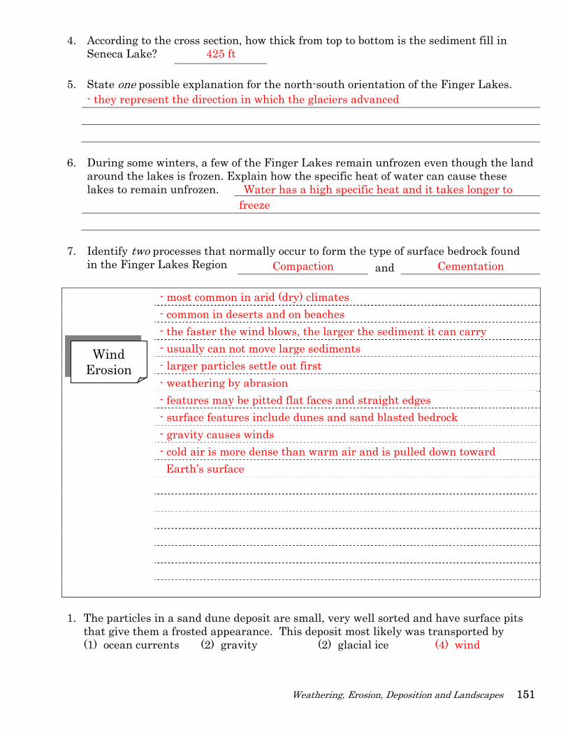
in the Finger Lakes Region Compaction and Cementation - most common in arid (dry) climates
- common in deserts and on beaches - the faster the wind blows, the larger the sediment it can carry - usually can not move large sediments - larger particles settle out first - weathering by abrasion - features may be pitted flat faces and straight edges - surface features include dunes and sand blasted bedrock - gravity causes winds - cold air is more dense than warm air and is pulled down toward Earth’s surface
1. The particles in a sand dune deposit are small, very well sorted and have surface pits
that give them a frosted appearance. This deposit most likely was transported by (1) ocean currents (2) gravity (2) glacial ice (4) wind
Wind Erosion
152 ESworkbooks©2008cdunbar
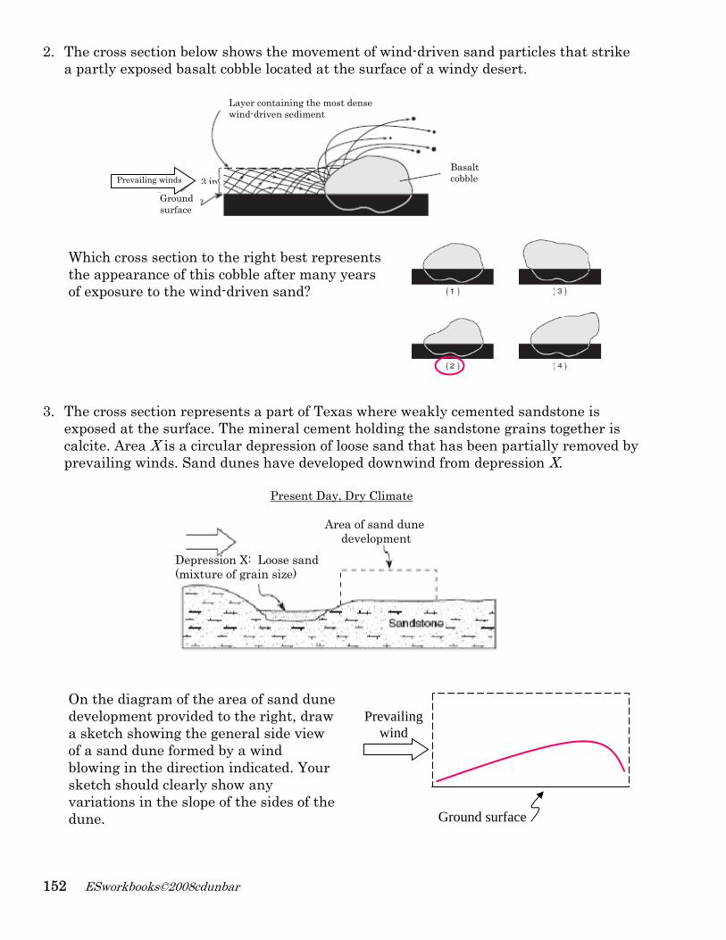
2. The cross section below shows the movement of wind-driven sand particles that strike a partly exposed basalt cobble located at the surface of a windy desert. Which cross section to the right best represents the appearance of this cobble after many years of exposure to the wind-driven sand?
3. The cross section represents a part of Texas where weakly cemented sandstone is
exposed at the surface. The mineral cement holding the sandstone grains together is calcite. Area X is a circular depression of loose sand that has been partially removed by prevailing winds. Sand dunes have developed downwind from depression X.
On the diagram of the area of sand dune development provided to the right, draw a sketch showing the general side view of a sand dune formed by a wind blowing in the direction indicated. Your sketch should clearly show any variations in the slope of the sides of the dune.
Present Day, Dry Climate
Area of sand dune development
Depression X: Loose sand (mixture of grain size)
Prevailing wind
Ground surface
Ground surface
Prevailing winds Basalt cobble
Layer containing the most densewind-driven sediment
3 in
Weathering, Erosion, Deposition and Landscapes 153
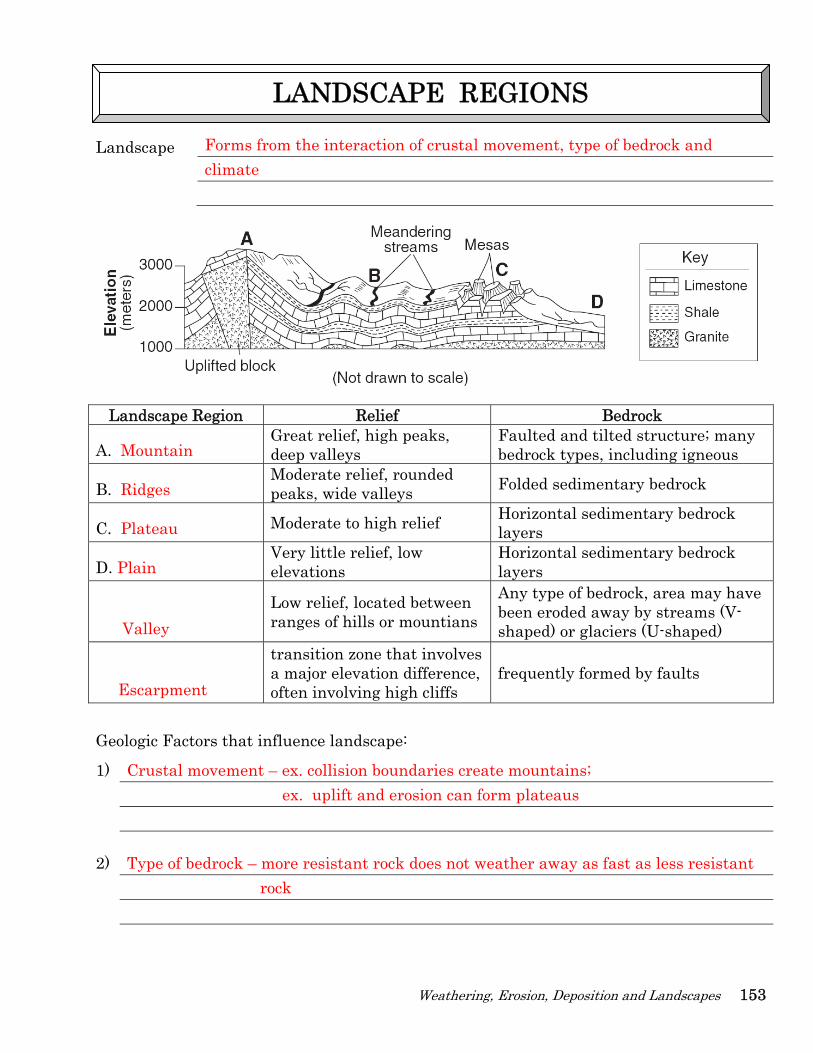
Landscape Forms from the interaction of crustal movement, type of bedrock and climate
Landscape Region Relief Bedrock
A. Mountain Great relief, high peaks, deep valleys
Faulted and tilted structure; many bedrock types, including igneous
B. Ridges Moderate relief, rounded peaks, wide valleys Folded sedimentary bedrock
C. Plateau Moderate to high relief Horizontal sedimentary bedrock layers
D. Plain Very little relief, low elevations
Horizontal sedimentary bedrock layers
Valley Low relief, located between ranges of hills or mountians
Any type of bedrock, area may have been eroded away by streams (V-shaped) or glaciers (U-shaped)
Escarpment
transition zone that involves a major elevation difference, often involving high cliffs
frequently formed by faults
Geologic Factors that influence landscape:
1) Crustal movement – ex. collision boundaries create mountains; ex. uplift and erosion can form plateaus 2) Type of bedrock – more resistant rock does not weather away as fast as less resistant rock
LANDSCAPE REGIONS
154
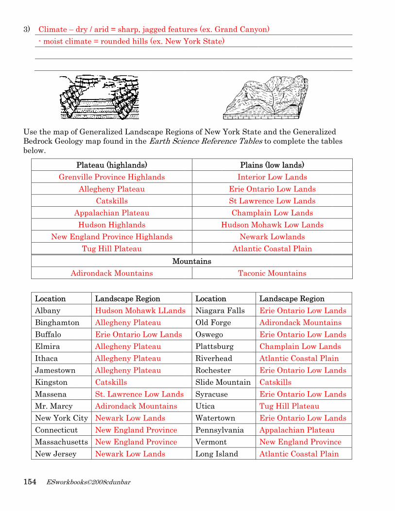
3) UseBedbelo
LABBEIJKMMNCMN
ESworkbo
Climate – - moist clim
the map odrock Geoloow.
Gren
New E
A
Location Albany BinghamtoBuffalo Elmira Ithaca JamestownKingston Massena Mr. Marcy New York CConnecticuMassachusNew Jersey
books©2008cd
dry / arid mate = rou
of Generaliogy map fou
Plateau (hnville Prov
AlleghenCats
AppalachiaHudson H
England PrTug Hill
Adirondack
LandHud
on AllegErie AllegAlleg
n AllegCatsSt. LAdir
City Newut Newsetts Newy New
dunbar
= sharp, jaunded hills
zed Landscund in the
highlands) vince Highly Plateau skills an Plateau
Highlands ovince Higl Plateau
k Mountain
dscape Regson Mohawgheny PlatOntario L
gheny Platgheny Platgheny Platskills Lawrence Londack Mo
wark Low Lw England Pw England Pwark Low L
agged featu (ex. New Y
cape RegioEarth Scie
ands
u
ghlands
Mouns
gion wk LLandsteau ow Lands
teau teau teau
Low Landsountains
Lands Province Province
Lands
ures (ex. GrYork State
ons of New ence Refere
H
untains
Locatios Niagara
Old ForOswegoPlattsbuRiverheRochestSlide MSyracusUtica WatertoPennsyVermonLong Is
rand Canye)
York Stateence Table
PlainInterio
Erie OntSt LawreChampl
Hudson MoNewa
Atlantic
Tacon
n a Falls rge o urg ead ter
Mountain se
own lvania
nt sland
on)
e and the Ges to comple
ns (low landor Low Lantario Low Lence Low Llain Low Lohawk Low
ark Lowlanc Coastal P
nic Mounta
LandscapeErie OntarAdirondacErie OntarChamplainAtlantic CErie OntarCatskills Erie OntarTug Hill PErie OntarAppalachiNew EnglaAtlantic C
Generalizedete the tab
ds) nds Lands Lands
Lands w Lands nds Plain
ins
e Region rio Low La
ck Mountairio Low Lan Low Lan
Coastal Plairio Low La
rio Low LaPlateau rio Low Laan Plateauand Provin
Coastal Plai
d les
ands ins ands nds in
ands
ands
ands u nce in
Weathering, Erosion, Deposition and Landscapes 155
1. The major landscape regions of the United States are identified chiefly on the basis of (1) similar surface characteristics (3) nearness to major mountain regions (2) similar climatic conditions (4) nearness to continental boundaries
2. Which city is located in a landscape region showing distorted and altered bedrock structure? (1) Old Forge (2) Niagara Falls (3) Syracuse (4) Binghamton
3. Which New York State landscape region has intensely metamorphosed surface
bedrock? (1) Appalachian Plateau (3) Adirondacks Mountains (2) Atlantic Coastal Plain (4) Erie-Ontario Lowlands
4. Which city is located in the St. Lawrence Lowlands?
(1) Kingston (2) Massena (3) Rochester (4) Albany 5. Which characteristics of Earth’s surface can be determined by using a topographic
map? (1) Hill slope and stream gradients (2) Bedrock erosion and stream velocity (3) Hilltop elevations and bedrock age (4) Soil thickness and benchmark movement
6. Which New York State landscape region contains the oldest surface bedrock?
(1) Erie- Ontario Lowlands (3) Adirondack Mountains (2) Allegheny Plateau (4) Tug Hill Plateau
7. In which type of landscape are meandering streams most likely found? (1) regions of waterfalls (3) steeply sloping hills (2) gently sloping plains (4) V-shaped valleys
8. Which evidence best indicates that a landscape has been eroded by streams? (1) parallel sets of U-shaped valleys (3) thick residual soil (2) sand dunes (4) sorted layers of cobbles and sand
9. The landscape of northeastern New York State was formed mainly by (1) mountain building and glacial erosion (2) faulting and volcanic activity (3) changes in the water level of Lake Ontario (4) erosion of Devonian sedimentary bedrock by rivers
10. Which location is on a plateau landscape?
(1) Rochester (2) Elmira (3) Old Forge (4) New York City
11. The boundaries between landscape regions are usually determined by the location of (1) plate boundaries (3) population density (2) major cities (4) well-defined surface features
156 ESworkbooks©2008cdunbar
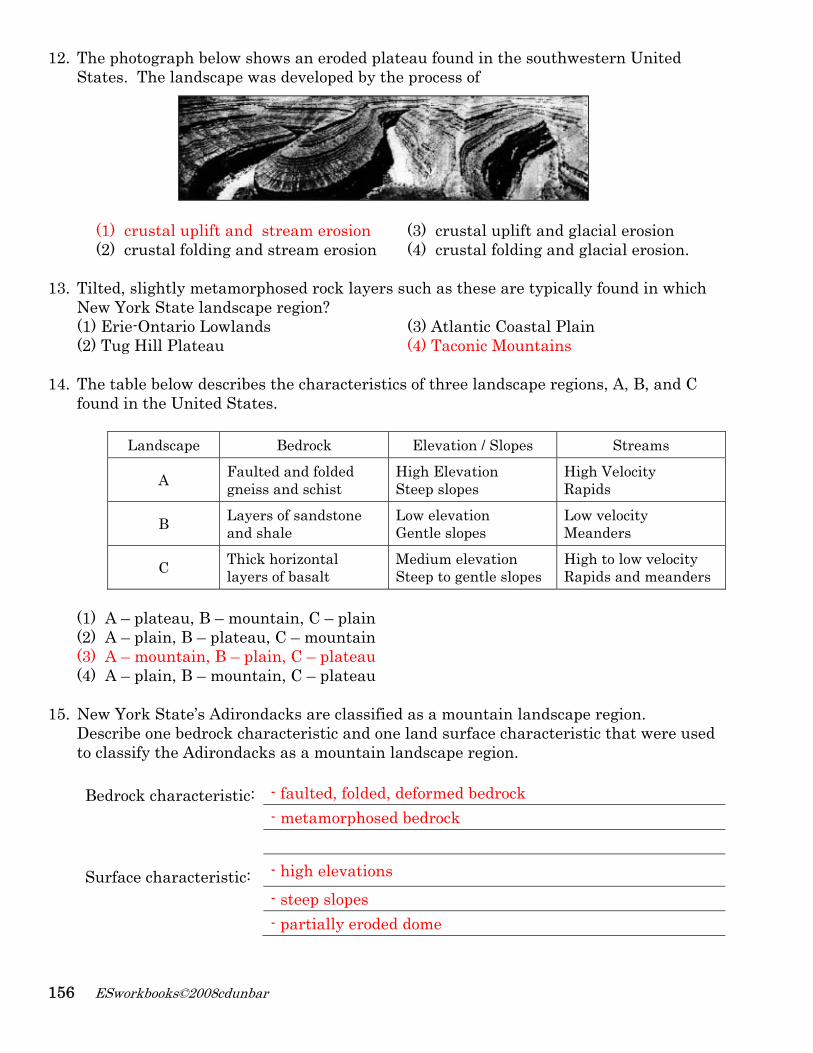
12. The photograph below shows an eroded plateau found in the southwestern United States. The landscape was developed by the process of
(1) crustal uplift and stream erosion (3) crustal uplift and glacial erosion (2) crustal folding and stream erosion (4) crustal folding and glacial erosion.
13. Tilted, slightly metamorphosed rock layers such as these are typically found in which New York State landscape region? (1) Erie-Ontario Lowlands (3) Atlantic Coastal Plain (2) Tug Hill Plateau (4) Taconic Mountains
14. The table below describes the characteristics of three landscape regions, A, B, and C found in the United States.
Landscape Bedrock Elevation / Slopes Streams
A Faulted and folded gneiss and schist
High Elevation Steep slopes
High Velocity Rapids
B Layers of sandstone and shale
Low elevation Gentle slopes
Low velocity Meanders
C Thick horizontal layers of basalt
Medium elevation Steep to gentle slopes
High to low velocity Rapids and meanders
(1) A – plateau, B – mountain, C – plain (2) A – plain, B – plateau, C – mountain (3) A – mountain, B – plain, C – plateau (4) A – plain, B – mountain, C – plateau
15. New York State’s Adirondacks are classified as a mountain landscape region. Describe one bedrock characteristic and one land surface characteristic that were used to classify the Adirondacks as a mountain landscape region. Bedrock characteristic: - faulted, folded, deformed bedrock - metamorphosed bedrock
Surface characteristic: - high elevations - steep slopes - partially eroded dome
Weathering, Erosion, Deposition and Landscapes 157
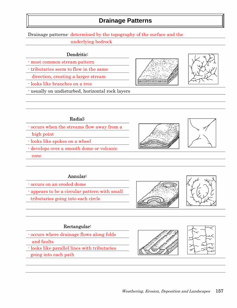
Drainage patterns- determined by the topography of the surface and the underlying bedrock
Dendritic: - most common stream pattern - tributaries seem to flow in the same direction, creating a larger stream - looks like branches on a tree - usually on undisturbed, horizontal rock layers
Radial:
- occurs when the streams flow away from a high point - looks like spokes on a wheel - develops over a smooth dome or volcanic cone
Annular:
- occurs on an eroded dome - appears to be a circular pattern with small tributaries going into each circle
Rectangular:
- occurs where drainage flows along folds and faults - looks like parallel lines with tributaries going into each path
Drainage Patterns
158 ESworkbooks©2008cdunbar
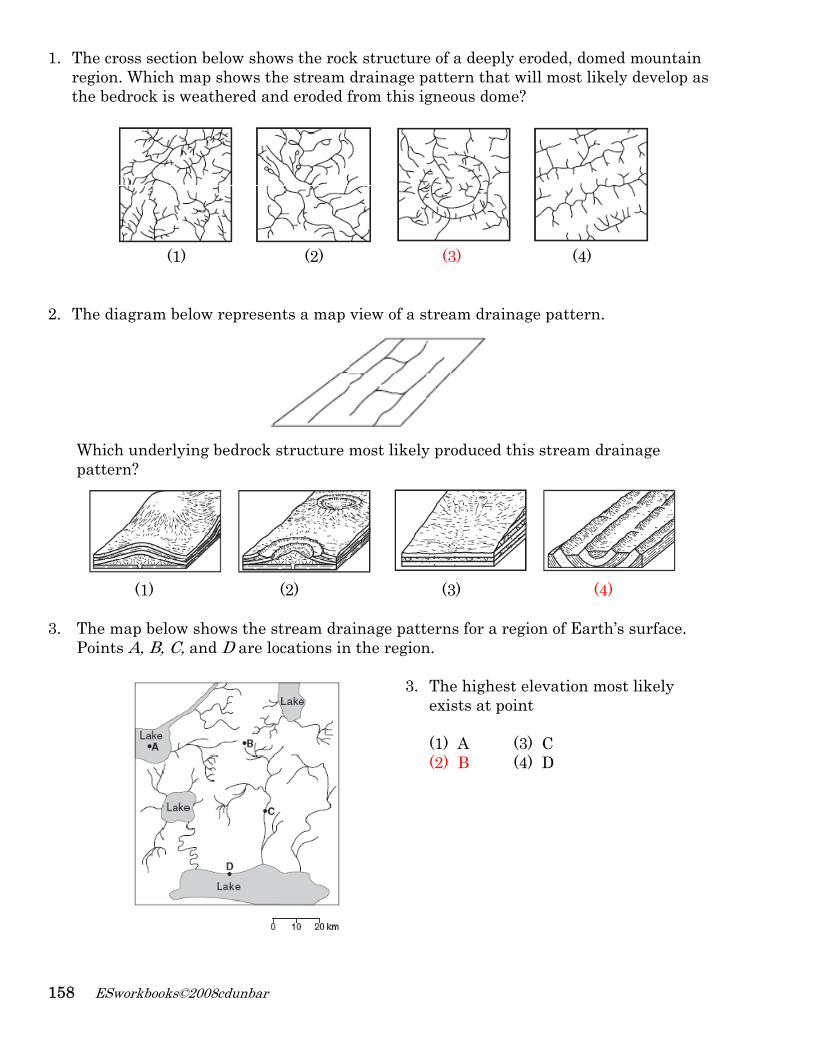
1. The cross section below shows the rock structure of a deeply eroded, domed mountain region. Which map shows the stream drainage pattern that will most likely develop as the bedrock is weathered and eroded from this igneous dome?
(1) (2) (3) (4)
2. The diagram below represents a map view of a stream drainage pattern.
Which underlying bedrock structure most likely produced this stream drainage pattern?
(1) (2) (3) (4)
3. The map below shows the stream drainage patterns for a region of Earth’s surface.
Points A, B, C, and D are locations in the region.
3. The highest elevation most likely exists at point (1) A (3) C (2) B (4) D
Weathering, Erosion, Deposition and Landscapes 159
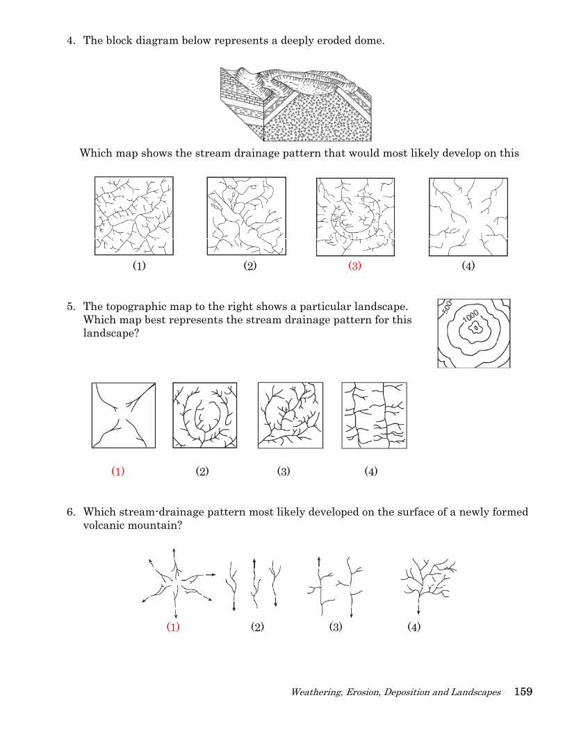
4. The block diagram below represents a deeply eroded dome.
Which map shows the stream drainage pattern that would most likely develop on this
(1) (2) (3) (4)
5. The topographic map to the right shows a particular landscape. Which map best represents the stream drainage pattern for this landscape?
(1) (2) (3) (4)
6. Which stream-drainage pattern most likely developed on the surface of a newly formed
volcanic mountain?
(1) (2) (3) (4)
160
1. Pcm((
2. Td
3.
4. Wo
5.
ESworkbo
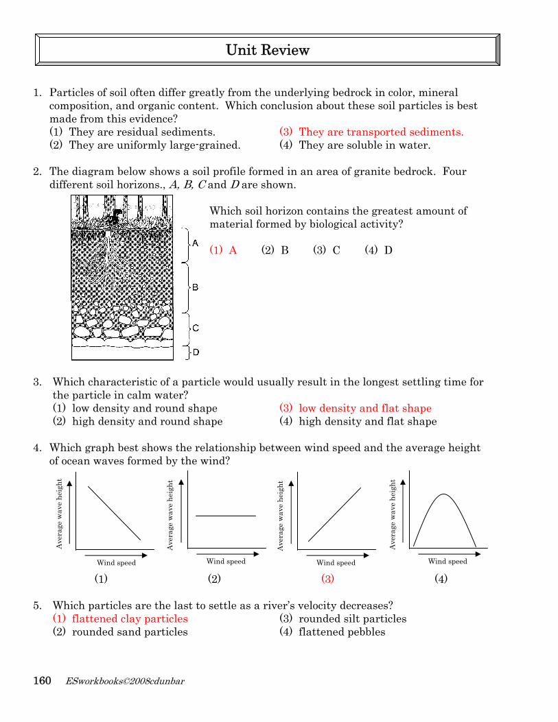
Particles ofcompositionmade from (1) They ar(2) They ar
The diagradifferent so
Which chathe particl(1) low de(2) high d
Which grapof ocean wa
(1)
Which par(1) flatten(2) rounde
Ave
rage
wav
e he
ight
Wi
books©2008cd
f soil often n, and orgathis eviden
re residualre uniform
m below shoil horizons
aracteristicle in calm wnsity and rensity and
ph best shoaves forme
)
rticles are tned clay paed sand pa
ind speed
dunbar
differ greaanic contennce? l sediments
mly large-gr
hows a soils., A, B, C a
c of a particwater? round shap
d round sha
ows the reld by the w
(
the last to rticles rticles
W
Ave
rage
wav
e he
ight
atly from thnt. Which c
s. rained.
l profile forand D are Which soilmaterial fo (1) A
cle would u
pe ape
ationship bind?
(2)
settle as a
Unit
Wind speed
he underlyconclusion
(3) Th(4) Th
rmed in an shown.
l horizon coormed by b
(2) B
usually resu
(3) low(4) hig
between wi
river’s velo(3) rou(4) flat
Review
Ave
rage
wav
e he
ight
ying bedroc about thes
ey are traney are solu
area of gra
ontains thebiological a
(3) C (
ult in the l
w density agh density a
ind speed a
(3)
ocity decreunded silt pttened peb
Wind speed
k in color, se soil part
nsported seuble in wat
anite bedro
e greatest aactivity?
(4) D
longest sett
nd flat shaand flat sh
and the av
eases? particles bles
Ave
rage
wav
e he
ight
mineral ticles is bes
ediments.er.
ock. Four
amount of
tling time
ape hape
erage heig
(4) Wind speed
st
for
ht
Weathering, Erosion, Deposition and Landscapes 161
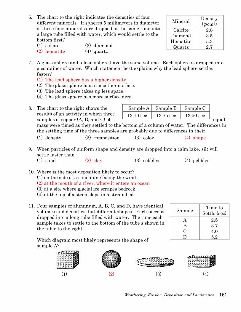
Mineral Density (g/cm3)
Calcite Diamond Hematite Quartz
2.8 3.5 5.3 2.7
6. The chart to the right indicates the densities of four different minerals. If spheres 5 millimeters in diameter of these four minerals are dropped at the same time into a large tube filled with water, which would settle to the bottom first? (1) calcite (3) diamond (2) hematite (4) quartz
7. A glass sphere and a lead sphere have the same volume. Each sphere is dropped into
a container of water. Which statement best explains why the lead sphere settles faster? (1) The lead sphere has a higher density. (2) The glass sphere has a smoother surface. (3) The lead sphere takes up less space. (4) The glass sphere has more surface area.
8. The chart to the right shows the
results of an activity in which three samples of copper (A, B, and C) of equal mass were timed as they settled to the bottom of a column of water. The differences in the settling time of the three samples are probably due to differences in their (1) density (2) composition (3) color (4) shape
9. When particles of uniform shape and density are dropped into a calm lake, silt will settle faster than (1) sand (2) clay (3) cobbles (4) pebbles
10. Where is the most deposition likely to occur? (1) on the side of a sand dune facing the wind (2) at the mouth of a river, where it enters an ocean (3) at a site where glacial ice scrapes bedrock (4) at the top of a steep slope in a streambed
11. Four samples of aluminum, A, B, C, and D, have identical volumes and densities, but different shapes. Each piece is dropped into a long tube filled with water. The time each sample takes to settle to the bottom of the tube s shown in the table to the right. Which diagram most likely represents the shape of sample A?
(1) (2) (3) (4)
Sample A Sample B Sample C 13.10 sec 13.75 sec 13.50 sec
Sample Time to Settle (sec)
A B C D
2.5 3.7 4.0 5.2
162 ESworkbooks©2008cdunbar
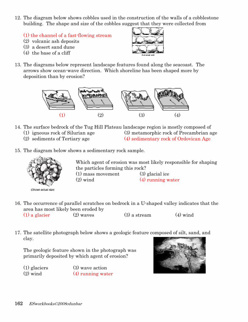
12. The diagram below shows cobbles used in the construction of the walls of a cobblestone building. The shape and size of the cobbles suggest that they were collected from (1) the channel of a fast-flowing stream (2) volcanic ash deposits (3) a desert sand dune (4) the base of a cliff
13. The diagrams below represent landscape features found along the seacoast. The arrows show ocean-wave direction. Which shoreline has been shaped more by deposition than by erosion?
(1) (2) (3) (4) 14. The surface bedrock of the Tug Hill Plateau landscape region is mostly composed of
(1) igneous rock of Silurian age (3) metamorphic rock of Precambrian age (2) sediments of Tertiary age (4) sedimentary rock of Ordovican Age
15. The diagram below shows a sedimentary rock sample. Which agent of erosion was most likely responsible for shaping the particles forming this rock? (1) mass movement (3) glacial ice (2) wind (4) running water
16. The occurrence of parallel scratches on bedrock in a U-shaped valley indicates that the
area has most likely been eroded by (1) a glacier (2) waves (3) a stream (4) wind
17. The satellite photograph below shows a geologic feature composed of silt, sand, and
clay. The geologic feature shown in the photograph was primarily deposited by which agent of erosion? (1) glaciers (3) wave action (2) wind (4) running water
Weathering, Erosion, Deposition and Landscapes 163
18. In which landscape region is Ithaca, New York located? (1) Allegheny Plateau (3) The Catskills (2) Adirondacks Highlands (4) St. Lawrence Lowlands
19. Match the agent of erosion that corresponds to the identifying characteristic surface features described below.
Agent of Erosion Surface Feature Formed C Glaciers A. Beach, sandbars, barrier islands E Mass movement B. Loss of topsoil, dunes D Running water (streams) C. U-shaped valley, moraines, drumlins A Waves D. V-shaped valley, deltas, meanders B Wind E. Landslides, slumps
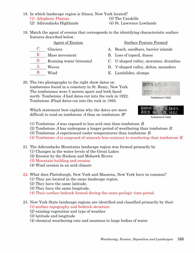
20. The two photographs to the right show dates on
tombstones found in a cemetery in St. Remy, New York. The tombstones were 5 meters apart and both faced north. Tombstone A had dates cut into the rock in 1922. Tombstone B had dates cut into the rock in 1892. Which statement best explains why the dates are more difficult to read on tombstone A than on tombstone B? (1) Tombstone A was exposed to less acid rain than tombstone B. (2) Tombstone A has undergone a longer period of weathering than tombstone B. (3) Tombstone A experienced cooler temperatures than tombstone B. (4) Tombstone A is composed of minerals less resistant to weathering than tombstone B.
21. The Adirondacks Mountains landscape region was formed primarily by (1) Changes in the water levels of the Great Lakes (2) Erosion by the Hudson and Mohawk Rivers (3) Mountain building and erosion (4) Wind erosion in an arid climate
22. What does Plattsburgh, New York and Massena, New York have in common?
(1) They are located in the same landscape region. (2) They have the same latitude. (3) They have the same longitude. (4) Their surface bedrock formed during the same geologic time period.
23. New York State landscape regions are identified and classified primarily by their (1) surface topography and bedrock structure (2) existing vegetation and type of weather (3) latitude and longitude (4) chemical weathering rate and nearness to large bodies of water
164 ESworkbooks©2008cdunbar
24. Which agent of erosion is mainly responsible for the formation of the depressions occupied by both the kettle lakes and finger lakes found in New York State? (1) wind (2) streams (3) waves (4) glaciers
25. The diagram below shows a section of a meander in a stream. The arrows show the direction of stream flow. The streambank on the outside of this meander is steeper
than the streambank on the inside of this meander because the water on the outside of this meander is moving
(1) slower, causing deposition (2) faster, causing deposition (3) slower, causing erosion
(4) faster, causing erosion
26. The cross section below shows a profile of a sediment deposit. The pattern of sediment size shown indicates that these sediments were most likely deposited within a (1) landslide (2) moraine (3) drumlin (4) delta
27. The map to the right shows a stream drainage pattern.
Arrows show the direction of stream flow.
On which landscape region did this drainage pattern most likely develop?
(1) (2) (3) (4) 28. A stream flowing at a velocity of 75 centimeters per second can transport
(1) clay, only (3) pebbles, sand, silt, and clay, only (2) pebbles, only (4) boulders, cobbles, pebbles, sand, silt, and clay
29. What will be the most probable arrangement of rock particles deposited directly by a glacier? (1) sorted and layered (3) sorted and not layered (2) unsorted and layered (4) unsorted and not layered
Weathering, Erosion, Deposition and Landscapes 165
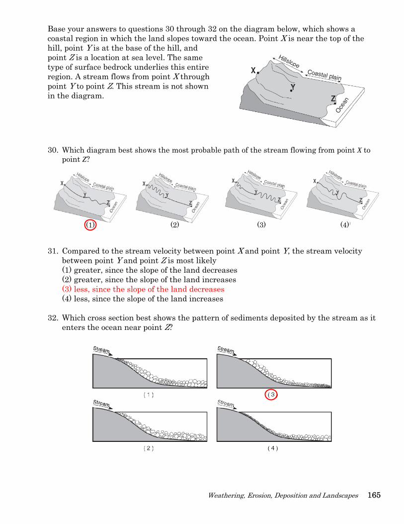
Base your answers to questions 30 through 32 on the diagram below, which shows a coastal region in which the land slopes toward the ocean. Point X is near the top of the hill, point Y is at the base of the hill, and point Z is a location at sea level. The same type of surface bedrock underlies this entire region. A stream flows from point X through point Y to point Z. This stream is not shown in the diagram.
30. Which diagram best shows the most probable path of the stream flowing from point X to
point Z?
31. Compared to the stream velocity between point X and point Y, the stream velocity between point Y and point Z is most likely (1) greater, since the slope of the land decreases (2) greater, since the slope of the land increases (3) less, since the slope of the land decreases (4) less, since the slope of the land increases
32. Which cross section best shows the pattern of sediments deposited by the stream as it enters the ocean near point Z?
(1) (2) (3) (4)
166 ESworkbooks©2008cdunbar
33. The map to the right shows barrier islands in the ocean along the coast of Texas. Which agent of erosion most likely formed these barrier islands? (1) mass movement (3) streams (2) wave action (4) glaciers
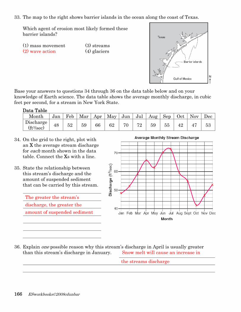
Base your answers to questions 34 through 36 on the data table below and on your knowledge of Earth science. The data table shows the average monthly discharge, in cubic feet per second, for a stream in New York State.
Data Table Month Jan Feb Mar Apr May Jun Jul Aug Sep Oct Nov Dec
Discharge (ft3/sec) 48 52 59 66 62 70 72 59 55 42 47 53
34. On the grid to the right, plot with
an X the average stream discharge for each month shown in the data table. Connect the Xs with a line.
35. State the relationship between this stream’s discharge and the amount of suspended sediment that can be carried by this stream.
The greater the stream’s discharge, the greater the amount of suspended sediment 36. Explain one possible reason why this stream’s discharge in April is usually greater
than this stream’s discharge in January. Snow melt will cause an increase in the streams discharge
X
X
X
X
X
X X
X
X
X
X
X