weathering and erosional processes; deserts of egypthomepages.wmich.edu/~kehew/geos 2020/weathering...
TRANSCRIPT

1
Weathering and erosional
processes; deserts of
Egypt
Classification of arid landscapes Hyperarid P/ETP <0.03 Arid 0.03-0.20
Semiarid 0.20-0.5 Subhumid 0.5-0.7
Characteristics of arid areas
Lack of continuous ground cover
Discontinuously flowing rivers (decrease in discharge downstream)
Accumulation of secondary minerals in soils (lack of recharge, upward movement of gw when wt is near surface)
Distribution of arid areas

2
Soils and weathering
Accumulation of salts
– Upward movement of ground water
– Lack of infiltration and leaching
– Source of wind blown salts
– Calcic horizons
– Main orders-aridisols, vertisols, entisols
Rock (desert) varnish
– Manganese and iron oxide coating produced by
manganese-oxidizing bacteria in alkaline environment
Mass wasting
– Angular, steep slopes; soil creep less important; talus common
Weathering
Mechanical (Physical)
–Pressure Release
–Thermal expansion
–Growth of crystals
Salt weathering
Frost heaving and cracking
–Plants and animals
Thermal expansion
Thermal stress fatigue or shock
Factors– Differential expansion of
minerals– High temperature
gradients-rapid heating during day raises T in outer layer—rapid cooling at night relative to interior
Cause tensional stresses in rock—microfractures, which gradually expand and lengthen
Moisture accelerates the process
Spalling caused by brush fire-granite
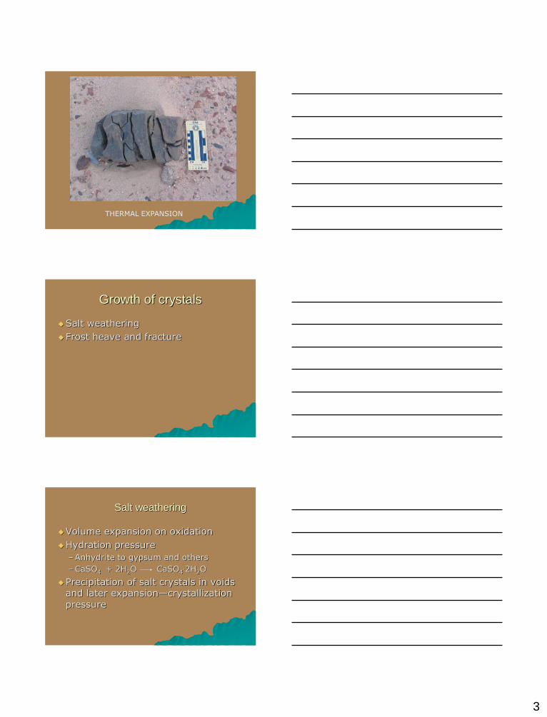
3
THERMAL EXPANSION
Growth of crystals
Salt weathering
Frost heave and fracture
Salt weathering
Volume expansion on oxidation
Hydration pressure
–Anhydrite to gypsum and others
–CaSO4 + 2H2O CaSO4.2H2O
Precipitation of salt crystals in voids and later expansion—crystallization pressure

4
Dendara Temple, Egypt
Tafoni
Frost action
Water expands 9% upon freezing, and even more if confined in a joint or fracture: however, this probably does not create enough pressure to fracture rocks. The process may involve freezing of a capillary film of adsorbed water and capillary movement through the rock toward the freezing front. May be able to expand microcracks and fractures.

5
Andesite slabs and fragments produced by frost shattering-southwestern
Montana
Canadian Rockies
Plants and animals—root growth in fractures; combination of physical and chemical process.

6
BIOLOGICAL ACTIVITY-
ROOT WEDGING
Chemical Weathering
Obelisk in Egypt Obelisk in New York
Chemical Weathering--Solution
CaSO4 . 2H2O Ca2+ + SO4
2- + 2H2O– Water not shown but must be present
– Reversible
– Congruent
CaCO3 + H2O Ca2+ + HCO3- + OH-
pH—negative log of hydrogen ion activity

7
Solution of limestone and dolomite; formation of sinkholes
and caves in humid climates. May play a role in formation
of depressions in the western desert.
Dahkla Oasis
5 miles
Chemical Weathering-Oxidation
FeS2 + 7/2H2O + 15/4 O2 Fe(OH)3 + 2SO42- +
4 H+
Oxidation—loss of electrons
Fe: Fe+2 – Fe+3 (1 electron) lost
S: S-1 – S +6 (14 electrons) lost
O: O0 – O-2 (3.75 x 2 x 2) = 15 electrons
gained

8
Oxidation-yellowish, reddish, brown colors
Chemical weathering--Carbonation
CO2 + H2O H2CO3
–Water not a strong acid by itself
–Much more aggressive when it reacts to form carbonic acid
–Reversible
–Origin of CO2 in subsurface: aerobic decomposition of organic matter
O2 + CH2O H2O + CO2
Chemical Weathering--Hydrolysis
MgSiO4 + 4H+ + 4OH- Mg2+ + 4OH- + H4SiO4
– Dissolution of olivine
– Reaction with dissociation products of water
– Congruent
2KAlSi3O8 + 2H2CO3 + 9H2O Al2Si2O5(OH)4 + 4H4SiO4 + 2K+ + 2HCO3
-
– K feldspar (orthoclase) to kaolinite
– Incongruent
– Irreversible
– Products: silicic acid, potassium ion, bicarbonate

9
Geomorphic processesSediment yield in drainage basins
Langbein-
Schumm
curve
Erosion by water
Precipitation in desert
– Very infrequent
– Occurs in thunderstorm, cloudburst events
– Rapid runoff because of lack of vegetation and steep slopes
– Dry valleys called wadis were originally formed in a wetter climate but are not dry.
– Flash floods in these wadis present a major geologic hazard to inhabitants.
Flash floods
En Gedi
Wadi Zin
Shortcut to En Gedi floods.lnk
Shortcut to Zin2.lnk

10
These pictures are from Wadi Hatzera, a small tributary of Wadi Zin in the 2004 flood. Water depth was 8 m, 4 m boulders were transported and the
flood was reconstructed at 600 m3/s—less than a 1% probability
Flash floods-Wadi Isla case history
3 miles
El-Qaa Plain
Wadi Isla

11
El Qaa plain with Sinai massif in
background
Mouth of Wadi Isla “canyon”
View downstream with Red Sea in distance

12
Wadi Isla Fan

13
17 m
Cemented Alluvium in Canyon-Pleistocene?
Flash flood competence

14
Boulder berms
Linear ridges of coarse clasts deposited by debris torrents (not debris
flows) along channel margins. Often located in zones of flow separation
near channel bends or changes in channel width (Carling, 1987).
Boulder berm height is an approximation of flow depth during flood.
~ 2m
~ 4 m
Estimation of velocity and
discharge in boulder berm reachManning Equation
V = R2/3 S1/2 n-1; whereR= hydraulic radius (A/P); where A = 65 x 4 = and P
=73 mS = slope (0.038)
n = Manning’s roughness coefficient (0.05), which is a reasonable value from previous studies such as
Costa (1983) and Williams (1983);
V ~ 9.2 m s-1
Q = VA = 2392 m3/s
65 m
4 m
Depth estimates in boulder berm
reach
Costa (1983) used four methods to estimate depth for flash floods in
small drainage basins in the Rocky Mountains: the Manning Equation,
stream power, the Shields function, and relative roughness.
For a velocity of 9.1 m3/s, the average of three of the four methods (one
was dropped for boulders over 0.6 m in diameter), the depth ranged from
5.9 m – 3.8 m, when slope was between 0.02 and 0.05, and n was
between 0.068 and 0.095. The height of the boulder berm falls within this
range.

15
Size measurements on boulder fan
Competence on boulder Fan
Clast imbrication and imbricate
cluster bedforms
Arrows show flow direction

16
Traverses and measurement
stations
Located by GPS
Intermediate axis of 5 largest clasts was measured at each location and averaged.
Velocity estimates Mean value for each
station was used to estimate velocity with the following equation, which is the average of four methods applied to Rocky Mountain flash floods.
V = 0.18 dI0.487,
in which dI is expressed
in mm. (Costa, 1983).
Mean velocity for each traverse
(m sec-1)

17
Wadi Isla
Geology
draped
over the
DEM
Preliminary Model Results
1. Storm Events for Wadi
Isla from 1998-2005
were correlated with
resultant discharge
amounts.
2. Forecasts show
precipitation amounts
required to achieve
discharge rates
determined by boulder
size.
Flood Analysis
R2 = 0.9127
0
400
800
1200
1600
2000
2400
0 20 40 60 80 100 120 140 160 180
Precipitation (mm)
Dis
charg
e (
m3/s
)
Observed Data Artificial Linear (Observed Data)
Paleoflood data from the Negev Desert, Israel. Curve A is
envelope curve for late Holocene paleofloods. (From Greenbaum
et al., QSR, 2006.

18
Dangers of flash flooding
A diversion ditch in Qena to convey floods through the city to the Nile
Desert landforms
Stream valleys-wide shallow channels, high bedload transport
Pediments
Desert plains and plateaus
– Bare surfaces
– Stony-lag concentrate from wind erosion (reg)
– Barren rock (hammada)
– Desert pavement, rocks in close contact, may be covered with desert varnish
– Sand seas (ergs)
Mountain landforms

19
Pediments
Mohave desert
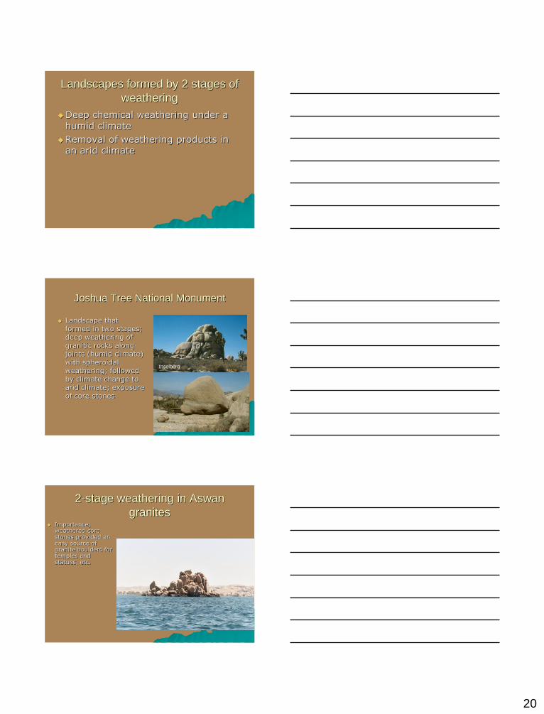
Inselbergs, Joshua TreeHow do pediments form?
3 miles
20
Landscapes formed by 2 stages of
weathering
Deep chemical weathering under a humid climate
Removal of weathering products in an arid climate
Joshua Tree National Monument
Landscape that formed in two stages; deep weathering of granitic rocks along joints (humid climate) with spheroidal weathering; followed by climate change to arid climate; exposure of core stones
Inselberg
2-stage weathering in Aswan
granites Importance;
weathered core stones provided an easy source of granite boulders for temples and statues, etc.

21
Reg surfaces
Giza Plateau El-Qaa Plain, Sinai
Hammadas
Desert pavement
Theories for origin
– Winnowing of fines by wind or water
– Heave of larger clasts due to swelling of clays or formation of salt crystals.
– Others

22
Desert varnish
Coating of manganese oxides on exposed rock surfaces. Involves oxidation and precipitation by microorganisms that can live in very alkaline conditions.
Wind erosion and transport
V*= √τ/ρ Drag velocity, proportional to log of height; function of wind velocity and surface roughness; Τ= shear
stress
Threshold velocity of particle motion

23
Wind erosion
Deflation
Abrasion
Forms
–Ventifacts
–Yardangs
Ventifacts (South Sinai)
Ventifacts-Iceland

24
Yardangs
Iran-largest on earth
Wind deposition
Sand shadows
Dunes
South Sinai
Dunes
25
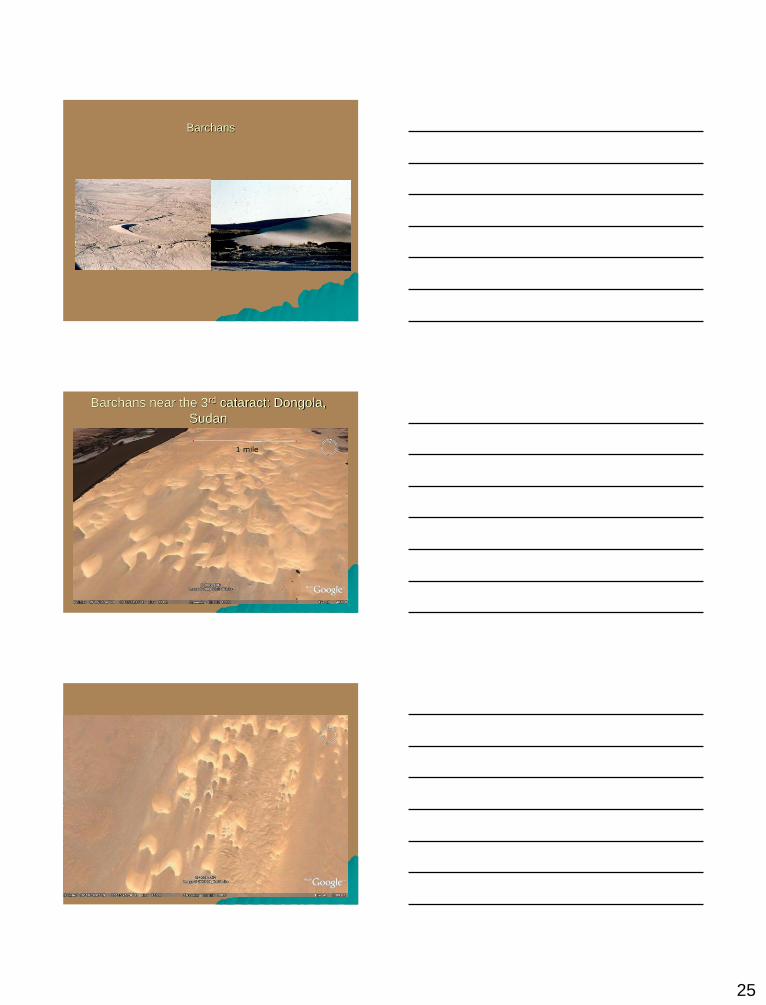
Barchans
Barchans near the 3rd cataract: Dongola,
Sudan
1 mile

26
Longitudinal (linear) dunes
Great Sand Sea, Western Desert
5 miles
Transverse dunes

27
Parabolic (blowout) dunes