waypoints use the “view notes page” to review this presentation
TRANSCRIPT

WAYPOINTSUse the “View Notes Page” to review this presentation.
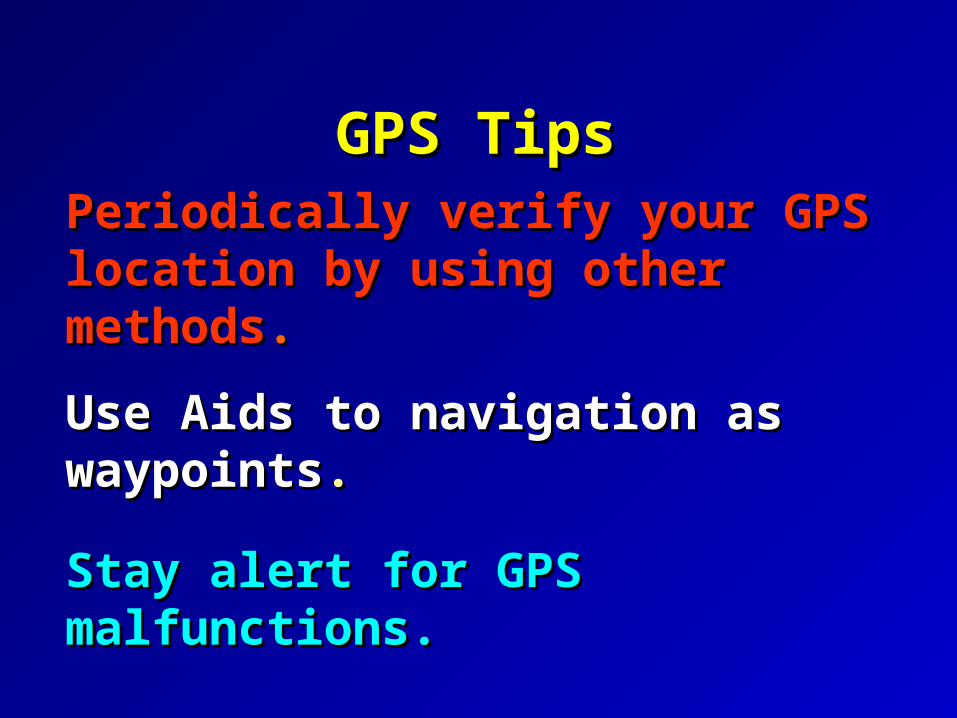
Periodically verify your GPS Periodically verify your GPS location by using other methodslocation by using other methods..
Use Aids to navigation as waypointsUse Aids to navigation as waypoints..
Stay alert for GPS malfunctions.Stay alert for GPS malfunctions.
GPS TipsGPS Tips

Waypoint Screen
Waypoint name
Reference waypoint
Bearing from reference waypoint
Position coordinates
Waypoint comment
Distance from reference waypoint

1. Learn how to 1. Learn how to inputinput waypoints.waypoints.
2. Learn how to 2. Learn how to useuse waypoints.waypoints.
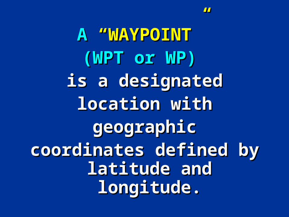
A A “WAYPOINT” “WAYPOINT” (WPT or WP) (WPT or WP)
is a designatedis a designatedlocation withlocation withgeographicgeographic
coordinates defined by coordinates defined by latitude and longitude.latitude and longitude.

longitude
latitude
Source of Waypoints
INPUT TO YOUR GPS:
Deg. Min. Sec.
41 10 00.000 N
070 40 00.000W

Latitude: 41º 15.5’ NLatitude: 41º 15.5’ N
Longitude: 71º 34.5’ WLongitude: 71º 34.5’ W
What is the fixed location of lighted buoy G “1B1” Fl G 4 sec What is the fixed location of lighted buoy G “1B1” Fl G 4 sec BELL, located just north of Sandy Point on Block Island?BELL, located just north of Sandy Point on Block Island?
ANIMATIONANIMATION
INPUT TO YOUR GPS:
Deg. Min. Sec.
41 15 30.000 N
071 34 30.000 W

Don’t be afraid to place Don’t be afraid to place Waypoints on the chartedWaypoints on the chartedlocation of an Aid to Navigation. location of an Aid to Navigation.
The odds are that it won’tThe odds are that it won’tactually be there due to itsactually be there due to itsWatch circle and natural Watch circle and natural influences.influences.
GPS TipsGPS Tips

*Use a minimum Use a minimum number of characters to number of characters to define a waypoint.define a waypoint.
*Maintain an EXCEL list of Maintain an EXCEL list of waypoints for reference.waypoints for reference.
GPS TipsGPS Tips

48 10 54 N48 10 54 N
123 06 37 W123 06 37 W
Light ListLight List

Waypoint Listing TRUE Meas'd Dist. GPS Latitude Longitude
WPT RTE LL No. Description HDG HDG nm Dist Deg M ins Deg M ins Type of Mark Date
001 1 Float at Dorchester Yacht Club Start 042 18.310 N 071 03.130 W Dock
003 1 Morrissey Blvd Bridge 112 0.239 042 18.220 N 071 02.830 W Outer Bridge Pier - South 10-Jun-01
004 1 11230 Dor. Bay Lighted Buoy 12 069 0.704 042 18.470 N 071 01.940 W Lighted Red Buoy 10-Jun-01
005 1 11210 Dor. Bay Lighted Buoy 5 041 0.764 042 19.050 N 071 01.267 W Lighted Green Buoy 10-Jun-01
006 1 11200 Dor. Bay Buoy 3 065 0.931 042 19.450 N 071 00.130 W Green Can 10-Jun-01
007 1 11579 Western Way Buoy 9 126 0.392 042 19.220 N 070 59.700 W Green Can 10-Jun-01
008 1 Right Pier Long Island Bridge 137 0.856 042 18.520 N 070 58.820 W Right Pier of Bridge 10-Jun-01
009 1 11554 Western Way Lighted Buoy 4 139 0.993 042 17.770 N 070 57.940 W Lighted Red Buoy 10-Jun-01
010 1 11514 Peddocks Is, Channel Buoy 2P 073 0.580 042 17.940 N 070 57.190 W Red Nun 10-Jun-01
011 1 11395 Nantasket Rds Lighted Buoy 11 064 1.638 042 18.660 N 070 55.200 W Lighted Green Buoy Fl G 2.5s 10-Jun-01
012 1 11370 Nantasket Rds Lighted Buoy 9 058 0.596 042 18.980 N 070 54.520 W Green Buoy 10-Jun-01
013 1 11355 Nantasket Roads Lighted Buoy 3 086 1.298 042 19.080 N 070 52.770 W Green Buoy 10-Jun-01
014 1 00435 Harding Ledge Lighted Bell Buoy 1HL 109 1.700 042 18.520 N 070 50.600 W Lighted Green Buoy Fl G 4s 10-Jun-01
015 1 00445 Davis Ledge Lighted Gong Buoy 1DL 118 4.765 042 16.300 N 070 44.900 W Green Buoy
N W
016 1 12258 Scituate Approach Lighted Gong Buoy SA 152 4.751 042 12.100 N 070 41.900 W Red and White Stripes
017 1 12490 Farnum Rock Lighted Bell Buoy 6 148 7.656 042 05.620 N 070 36.400 W Red Buoy
018 1 13035 Mary Ann Rocks Lighted Whistle Buoy 12 157 11.426 041 55.100 N 070 30.400 W Red Buoy
019 1 13065 Cape Cod Canal Entrance Buoy 7 176 8.521 041 46.600 N 070 29.600 W Red Buoy
EXCEL provides a more extensive media for a waypoint list than your
GPS set.
Use a simple waypoint numbering system to identify waypoints and avoid clutter on your GPS screen.
i.e. 001, 002, 003, 004, etc.
A great tool to use when you validate your waypoints.
Your EXCEL Waypoint listing can serve as a backup system when your GPS fails.

You need to learn how to:You need to learn how to:
• Store present positions.Store present positions.
• Enter a position.Enter a position.
• Rename, edit, and Rename, edit, and copycopy waypoints.waypoints.
• Create and edit Create and edit routes.routes.
• Delete Delete waypoints and routes.waypoints and routes.

Entering Waypoints
Waypoint name
Reference waypoint
Bearing from reference waypoint
Position coordinates
Waypoint comment
Distance from reference waypoint

Entering WaypointsEntering Waypoints• Enter in name/icon.
• Enter LAT/LON.
• Enter message
(not recommended)
• Waypoint number.
(Keep it simple)
• Menu of waypoint options at bottom.
• Bearing and Distance
0001
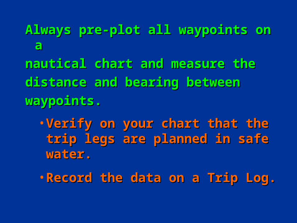
Always pre-plot all waypoints on aAlways pre-plot all waypoints on a
nautical chart and measure thenautical chart and measure the
distance and bearing betweendistance and bearing between
waypoints.waypoints.
• Verify on your chart that the trip Verify on your chart that the trip legs are planned in safe water.legs are planned in safe water.
• Record the data on a Trip Log.Record the data on a Trip Log.
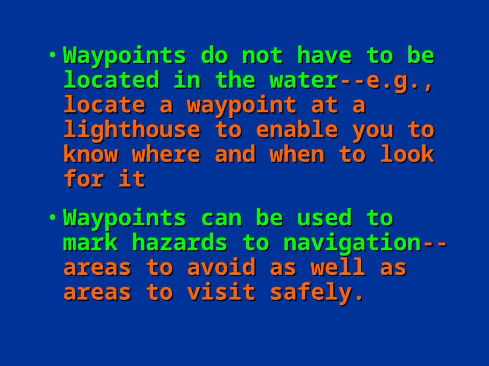
• Waypoints do not have to be Waypoints do not have to be located in the waterlocated in the water--e.g., locate --e.g., locate a waypoint at a lighthouse to a waypoint at a lighthouse to enable you to know where and enable you to know where and when to look for itwhen to look for it
• Waypoints can be used to mark Waypoints can be used to mark hazards to navigationhazards to navigation--areas to --areas to avoid as well as areas to visit avoid as well as areas to visit safely.safely.

• Select waypoints that can be easily verified by other methods--visual fixes, soundings, radar, etc.
NEVER rely on one
means of navigation.

Waypoint List
Waypoint List: 0020 Name: __________________________ 0016 42 12.06 N 070 41.90 W 0017 42 05.62 N 070 36.40 W 0018 41 55.10 N 070 30.40 W 0019 41 46.12 N 070 28.75 W 0020 ** **.** N *** **.** W 0021 42 19.60 N 071 00.10 W 0022 ** **.** N *** **.** W 0023 ** **.** N *** **.** W
Set Up Waypoint
Set up waypoint: ________________________ Display position as: LAT/LON 0020 42 16.50 N 071 39.55 W
A simple
waypoint
entry screen
Inserts WPT here

Scrolling on the Map Page
Use the cursor key
Scroll to specific coordinates or
To a course & distance or
Scroll to object on screen (if any)
Tip of arrow shows scroll position
Current position

The Waypoint Screen
Press “Mark” (enter key twice)
Bring up waypoint screen
Change name if desired
Date & time shown
Coordinates shown
Scroll to “OK” & press “Enter” to store waypoint

GPS TipsGPS Tips
• Waypoints do not have to be Waypoints do not have to be located in the water.located in the water.
• Waypoints can be used to mark Waypoints can be used to mark hazards to navigation--areas to hazards to navigation--areas to avoid and areas to visit.avoid and areas to visit.

WaypointsWaypoints are used extensively in are used extensively in GPS navigation:GPS navigation:
• As boundaries between As boundaries between voyage segments – LEGS. voyage segments – LEGS.
• To mark turning points, To mark turning points, destinations, and aids to destinations, and aids to navigation.navigation.
• To mark hazards to navigationTo mark hazards to navigation..

Verifying your planned Verifying your planned positions as a waypointpositions as a waypoint
• Use a simple numbering system.
• Validate every waypoint beforeusing it as a permanent waypointin a route.
WPT 1 WPT 2
WPT 3
WPT 4

Verifying your Waypoint
Press the “Mark” buttonBrings up Waypoint Screen

Waypoint UseWaypoint UseMark the Mark the
boundaries boundaries between legs.between legs.
WPT 1 WPT 2
WPT 3
WPT 4Marks the
turns in a
channel
Rock
Marks hazards to navigation or obstructions.

NAVIGATING WITH WAYPOINTS

Using GPSUsing GPSto Navigateto Navigate
Identify waypoint locations Identify waypoint locations
or the direction & distance or the direction & distance between them. between them.

Using GPSUsing GPSto Navigateto Navigate
• Plan a series of waypoints.Plan a series of waypoints.
• Check for obstacles between Check for obstacles between them—shoals, rocks, islands.them—shoals, rocks, islands.
• Check 1/4 mile either side of Check 1/4 mile either side of your planned course for your planned course for obstacles.obstacles.

GOTO NavigationGOTO Navigation• Used by any boat in Used by any boat in
open water to navigate open water to navigate to a single waypoint.to a single waypoint.
• Useful functions:Useful functions:– Range and BearingRange and Bearing– Speed of ApproachSpeed of Approach– TurnTurn
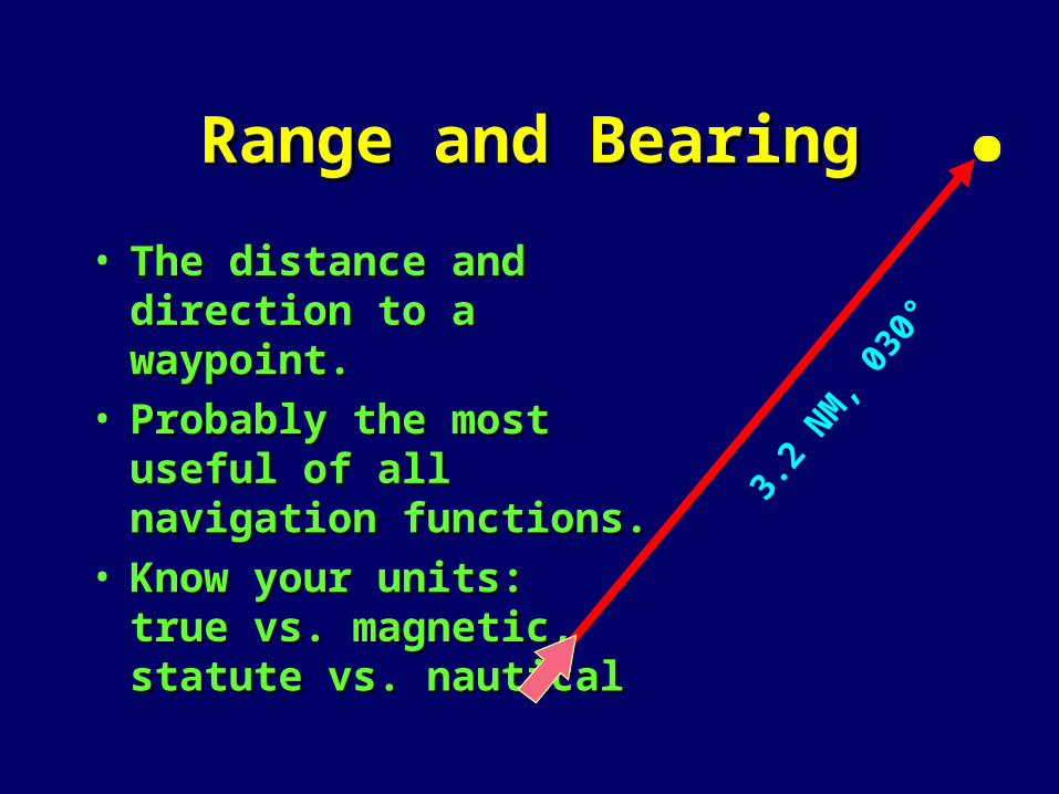
Range and BearingRange and Bearing
• The distance and direction The distance and direction to a waypoint.to a waypoint.
• Probably the most useful Probably the most useful of all navigation functions.of all navigation functions.
• Know your units: Know your units: true vs. magnetic, true vs. magnetic, statute vs. nauticalstatute vs. nautical
3.2
NM, 0
30°

Course To SteerCourse To Steer
• Course To Steer gets you back to the Course To Steer gets you back to the course line at a 45° intercept to try to course line at a 45° intercept to try to keep you out of troublekeep you out of trouble
BearingCTS
Desired Course Line
Third Reef

TR 224
D 3.1
TR 2
25D 2
.4ANIMATION
WP 2
WP 1
WP 3
Establish a XTE safety
zone
Measure, plot, and label your course lines.
Update your Trip Log.
Determine the LAT/LON for
each Waypoint and establish Waypoints in
your GPS.
On your nautical chart, stick small labels
showing the Waypoint Number beside each
WPT.

Plotting GPS PositionsPlotting GPS Positions
• Check positions periodically so Check positions periodically so that you will have a last known that you will have a last known position in the event of GPS position in the event of GPS receiver failure.receiver failure.
• Always plot your trips on a Always plot your trips on a nautical chart.nautical chart.
• Always use a Trip Log.Always use a Trip Log.

GPS TipsGPS Tips
NEVER rely on any one means of
navigation.

GPS TipsGPS Tips
• Use hand-held GPS units as backups Use hand-held GPS units as backups to ship-mounted units. to ship-mounted units. Carry extra batteriesCarry extra batteries
• Always use conventional paper Always use conventional paper charts with your GPS.charts with your GPS.

• It is important to It is important to check your chart check your chart before establishing before establishing WPTs.WPTs.
• If the course crosses If the course crosses an island, the GPS an island, the GPS receiver will direct receiver will direct you to navigate into you to navigate into this hazard.this hazard.
WPT 02
WPT 01

GPS TipsGPS Tips
Remember that the greatest Remember that the greatest
hazard to navigation may be a hazard to navigation may be a
bored navigator.bored navigator.