wauntysswg solar farm - gov.uk · v2 october 2017 authorisation rc v3 march 2018 client comments jm...
TRANSCRIPT


rpsgroup.com/uk
Wauntysswg Solar Farm
Hydrological Assessment
On Behalf of
Elgin Energy EsCo
Date: March 2018 Our Ref: JER1377
RPS Suite D10 Josephs Well Hanover Walk Leeds LS3 1AB Tel: (0)113 220 6190 Email: [email protected]

JER1377 – Wauntysswg Solar Farm i March 2018
rpsgroup.com/uk
Quality Management
Prepared by:
Angus Kerry
Reviewed by:
Jonathan Morley
Authorised by:
Richard Chalmers
Date: March 2018
Revision: Rv2
Project Number: JER1377 – Wauntysswg Solar Farm
Document Reference: 180423 R JER1377 JM Wauntysswg Solar v3.0 TCs
Document File Path: O:\JER1377 - Land at Wauntysswg Farm\5. Reports\Hydrology\1. Draft Report\171102 R JER1377 JM Wauntysswg Solar v3.docx
COPYRIGHT © RPS
The material presented in this report is confidential. This report has been prepared for the exclusive use of Elgin Energy EsCo and
shall not be distributed or made available to any other company or person without the knowledge and written consent of Elgin
Energy EsCo or RPS.

JER1377 – Wauntysswg Solar Farm ii March 2018
rpsgroup.com/uk
Amendment Record
Revision No. Date Reason for Change Authors Initials
V0 October 2017 Drafting AK
V1 October 2017 Review JM
V2 October 2017 Authorisation RC
V3 March 2018 Client comments JM

JER1377 – Wauntysswg Solar Farm iii March 2018
rpsgroup.com/uk
1 This report contains only that available factual data for the site which was obtained from the
sources described in the text. The data were related to the site on the basis of the location
information made available to RPS and its sub-consultants by the client.
2 The assessment of the site is based on information supplied by the client and onsite inspections
by RPS and its sub-consultants. Relevant information was also obtained from other sources.
3 The report reflects both the information provided to RPS and its sub-consultants in documents
made available for review and the results of observations and consultations by RPS staff and its sub-consultants.
4 Where data has been supplied by the client or other sources, including that from previous site
audits or investigations, it has been assumed that the information is correct but no warranty is
given to that effect. While reasonable care and skill has been applied in review of this data no
responsibility can be accepted by RPS for inaccuracies in the data supplied.
5 This report is prepared and written in the context of the proposals stated in the introduction to this
report and its contents should not be used out of context. Furthermore new information,
developing practices and changes in legislation may necessitate revised interpretation of the report after its original submission.
6 The copyright in the written materials shall remain the property of the RPS Company but with a
royalty-free perpetual licence to the client deemed to be granted on payment in full to the RPS
Company by the client of the outstanding amounts.
7 The report is provided for sole use by the addressees and is confidential to them and their
professional advisors. No responsibility whatsoever for the contents of the report will be accepted
to any person other than the Addressees.

JER1377 – Wauntysswg Solar Farm iv March 2018
rpsgroup.com/uk
Executive Summary
S1 RPS has undertaken a site-specific hydrological assessment for a prospective 30 MW solar park
and ancillary development at Wauntysswg Farm, Abertysswg, Rhymney, Tredegar NP22 5BQ.
S2 NRW TAN 15 DAM indicates that the whole site is located in Zone A, defined as areas
considered to be at little or no risk of fluvial or coastal/tidal flooding.
S3 NRW surface water flood mapping indicates that the majority of the site is at ‘very low’ risk of
flooding. Localised areas within the application site are defined as being at low to high risk of
surface water flooding, primarily associated with localised low lying areas and field drainage
where a degree of natural ponding may occur.
S4 Site topography indicates that surface water runoff would be conveyed in a general west-
southwest direction by virtue of ground levels and contours.
S5 There will be a negligible increase in impermeable area as a consequence of the development,
and therefore would not require any specific surface water management.
S6 The solar panel/bank design, as well as surface water and soil management measures will
ensure that there is no alteration to local drainage patterns direction within the application area
and no increases in suspended sediments within the drainage channels or surface water runoff.
S7 SuDS techniques will be incorporated, where required, into the final design and will work in conjunction with natural field drainage to manage any potential increases in surface water
discharge from the application site.
S8 Any existing field or tile drainage system will be restored where affected by construction and
maintained by the client for the life of the development.
S9 All areas of the application area, where appropriate, will have vegetation cover at all times.
S10 Where construction has resulted in soil compaction during construction, the areas between panel
rows would be tilled / scarified to an appropriate depth and then re-seeded with an appropriate vegetation cover.
S11 The installation of solar panels within the application has been determined to have negligible
hydrological impacts on surrounding ecological sensitive habitats.
S10 The proposed development is at low risk of flooding and with appropriate surface water and soil
management measures would cause negligible effects on the hydrological or ecological regimes.

JER1377 – Wauntysswg Solar Farm v March 2018
rpsgroup.com/uk
Contents
Quality Management .............................................................................................................................. i Amendment Record .............................................................................................................................. ii Executive Summary ............................................................................................................................. iv Contents ................................................................................................................................................ v Tables, Drawings & Appendices .........................................................................................................vii 1 Scope of Work ....................................................................................................................... 1
1.1 Background ........................................................................................................................... 1 1.2 Project Scope ........................................................................................................................ 1 1.3 Report Structure .................................................................................................................... 1
2 Sources of Information ......................................................................................................... 2 2.1 Introduction ........................................................................................................................... 2 2.2 Legislation and Guidance ..................................................................................................... 3
3 Site Setting ............................................................................................................................ 6 3.1 Site Location ......................................................................................................................... 6 3.2 Existing Development ........................................................................................................... 6 3.3 Proposed Development ........................................................................................................ 6 3.4 Topography ........................................................................................................................... 6 3.5 Ecological Areas ................................................................................................................... 7
4 Hydrological Baseline ........................................................................................................... 8 4.1 Hydrological Overview .......................................................................................................... 8 4.2 Fluvial and Tidal Flooding .................................................................................................... 8 4.3 Flood Defences ..................................................................................................................... 9 4.4 Flooding from rising / high groundwater ............................................................................. 9 4.5 Source Protection Zones ...................................................................................................... 9 4.6 Reservoir Failure Assessment ............................................................................................. 9 4.7 Surface water flooding .......................................................................................................... 9 4.8 Historical flood events .........................................................................................................10 4.9 Current Flood Risk ...............................................................................................................10
5 Development Impacts ..........................................................................................................11 5.1 Introduction ..........................................................................................................................11 5.2 Effects of solar panel arrays on runoff................................................................................11 5.3 Hydrological / Ecological .....................................................................................................13
6 Surface Water and Soil Management ..................................................................................14 6.1 Introduction ..........................................................................................................................14 6.2 Sustainable Drainage Systems (SuDS) ...............................................................................14 6.3 Soil Management Measures .................................................................................................15
7 Off-site Impacts and Residual Risks ...................................................................................16

JER1377 – Wauntysswg Solar Farm vi March 2018
rpsgroup.com/uk
8 Summary and Conclusions .................................................................................................17 8.1 Summary ..............................................................................................................................17 8.2 Flood Risk ............................................................................................................................17 8.3 Hydrological Appraisal ........................................................................................................17 8.4 Surface Water and Soil Management Measures .................................................................17 8.5 Conclusion ...........................................................................................................................18
References ...........................................................................................................................................19 Drawings ..............................................................................................................................................20 Appendices ..........................................................................................................................................21

JER1377 – Wauntysswg Solar Farm vii March 2018
rpsgroup.com/uk
Tables, Drawings & Appendices
Table
Table 1 - Information Sources Consulted during preparation of the Report .............................................. 2 Table 2 - Reports consulted during preparation of the document ............................................................. 2
Figures
Figure 1 - TAN 15 Development Advice Map ........................................................................................... 8 Figure 2 - NRW Surface Water Map .......................................................................................................10 Figure 3 - Typical Solar Panel installation ...............................................................................................12
Drawings
Drawing 1 Site Location Plan / Existing Site Layout
Drawing 2 Proposed Development Layout
Drawing 3 Ecological Sensitive Area
Appendices
Appendix 1 Topography
Appendix 2 NRW Surface Water Direction Flood Risk Map
Appendix 3 DTM Flow Pathway Assessment Map

JER1377 – Wauntysswg Solar Farm 1 March 2018
rpsgroup.com/uk
1 Scope of Work
1.1 Background
At the request of Elgin Energy EsCo, RPS Planning and Development Ltd (RPS) has carried out 1.1.1
a site-specific Hydrological Assessment for a prospective 30 MW solar park and ancillary development at Wauntysswg Farm, Abertysswg, Rhymney, Tredegar NP22 5BQ. The report has
been produced cognisant of the Planning Policy Wales (PPW) and Technical Advice Note 15
(TAN15).
1.2 Project Scope
This report assesses the potential hydrological impacts as a consequence of the proposed Solar 1.2.1Farm on identified ecological sensitive areas along the southern, eastern and western extents of
the site.
1.3 Report Structure
The Hydrological Assessment has the following structure: 1.3.1
Section 2 identifies the sources of information that have been consulted in preparation of
the assessment report and outlines the guidance and legislation driving the assessment.
Section 3 is a review of the site and environs including reviews of the existing character
and outlines the proposed development.
Section 4 outlines the existing hydrological baseline. Section 5 outlines development impacts from the installation of solar panels.
Section 6 provides an outline of surface water and soil management measures that could
be incorporated in the final development design to address hydrological impacts.
Section 7 outlines off-site impacts and residual risk caused by the development.
Section 8 presents a summary and conclusions.

JER1377 – Wauntysswg Solar Farm 2 March 2018
rpsgroup.com/uk
2 Sources of Information
2.1 Introduction
Table 1 below lists the information sources consulted during preparation of this report. 2.1.1
Table 1 - Information Sources Consulted during preparation of the Report
Source Data Information consulted/ provided
Site setting and
hydrology. OS Mapping 1: 50 000 Sheet 161: The Black Mountains.
Area information, rivers and other
watercourses, general Site environs,
built environment, catchment Information.
British Geological
Survey.
BGS (online) Geology of Britain Viewer.
Available at: http://mapapps.bgs.ac.uk/geologyofbritain/home.html
Site and area geology.
National Resources
Wales (NRW).
National Resources Wales data holdings, customer service
and engagement team.
Current flood risk, local flood
defences, flood levels, supplementary
geology and groundwater information.
Local Planning
Authority (LPA):
Blaenau Gwent County
Borough Council.
Blaenau Gwent County Borough Council – Local
Development Plan up to 2021.
Flood Zoning
Local Development Framework.
Water Utility Company. Dŵr Cymru (Welsh Water) utility assets. Water and sewerage assets in the
vicinity of the Site.
Welsh Government. Planning Policy Wales.
Technical Advice Notice 15: Development and Flood Risk.
Flood zoning for the site as used by
the NRW in Wales.
The reports consulted during the preparation of this document are listed below: 2.1.2
Table 2 - Reports consulted during preparation of the document
Source Data Information consulted/ provided
Blaenau Gwent County
Borough Council.
Blaenau Gwent County Borough Council, May 2013.
Local Flood Risk Management Strategy.
Local Authority plan to highlight
potential hazards from flooding and set
out how risk management authorities
work with communities to manage flood risk.
Blaenau Gwent County Borough Council, January 2013.
Local Flood Risk Management Strategic Environmental Assessment Report
Local Authority plan to highlight
potential hazards from flooding and set
out how risk management authorities
work with communities to manage flood
risk.
Bronwen Thomas Landscape Architect (March 2009).
Proposal for designation of special landscape areas in Study of the Special Landscape Areas

JER1377 – Wauntysswg Solar Farm 3 March 2018
rpsgroup.com/uk
Blaenau Gwent (SLAs) in the county.
2.2 Legislation and Guidance
The Welsh Government’s policy on development and flood risk is set out in PPW and TAN15. 2.2.1
The documents emphasise the key role of the planning system in managing flood risk, and the
contribution of planning to mitigate and adapt to climate change. A summary of key policies is set out below:
Planning Policy Wales.
PPW sets out the land use planning policies of the Welsh Government. Chapter 13 ‘Minimising 2.2.2and Managing Environmental Risk and Pollution’ outlines the Welsh Government’s objectives in
terms of addressing flood risk.
Paragraph 13.4 states: 2.2.3
Development proposals in areas defined as being of high flood hazard should only be
considered where:
New development can be justified in that location, even though it is likely to be at risk from
flooding; and
The development proposal would not result in the intensification of existing development
which may itself be at risk; and
New development would not increase the potential adverse impacts of a flood event.
Technical Advice Note 15
TAN15 provides technical guidance which supplements the policy set out in PPW in relation to 2.2.4development and flooding. It advises on development and flood risk as this relates to
sustainability principles and provides a framework within which risks arising from both river and
coastal flooding and additional run-off from development in any location can be assessed.
TAN15 requires the application of a sequential risk-based approach to determining the suitability 2.2.5
of land for development in flood risk areas, and that an FCA should be carried out to the
appropriate degree (if required), at all levels of the planning process.
Climate Change
The TAN 15 sets out how the planning system should help minimise vulnerability and provide 2.2.6resilience to the impacts of climate change. TAN 15 and PPW explain when and how FCAs
should be used. This includes demonstrating how flood risk will be managed now and over the
development’s lifetime, taking climate change into account.
In August 2016 the NRW updated advice on climate change allowances to support TAN 15. 2.2.7
New guidance requires that flood risk assessments and strategic flood risk assessments, assess

JER1377 – Wauntysswg Solar Farm 4 March 2018
rpsgroup.com/uk
both the central and upper end allowances to understand the range of impact. The site sits
within the Severn River Basin District Boundary.
The climate change guidance notes that the allowances provided have been derived from 2.2.8
national scale research. There may be cases where local evidence supports the use of other
local climate change allowances. With specific reference to changes to extreme rainfall LIT 5707
notes that UKCP09 provides useful information on change to rainfall across the UK.
Runoff and attenuation calculation for any development design would have to take into account 2.2.9the above change in climate change policy.
Blaenau Gwent County Borough Council – Local Development Plan.
The Local Development Plan (LDP) sets out detailed planning policies and proposals for 2.2.10Blaenau Gwent County.
The LDP guides the future development of an area. It provides a clear vision for how new 2.2.11
development can be address the challenges faced by the County and where, when and how
much new development can take place up to 2021. The aim is to provide developers and the
public with certainty about the planning framework for Blaenau Gwent.
The strategic policies relevant to hydrology, flood risk and ecology are outlined below; 2.2.12
SP7 – Climate Change
The Council will seek to address climate change and reduce energy demand to improve the 2.2.13sustainability of the valley communities in Blaenau Gwent by:
1. Adapting to direct and indirect impacts of climate change through:
a) Ensuring that developments accord with objectives of sustainability and good design;
b) Directing new development away from those areas which are at high risk of flooding;
and
c) Managing flood risk through incorporating measures in design and construction to
reduce the effects of flooding.
SP10 – Protection and Enhancement of the Natural Environment
Blaenau Gwent’s unique, natural environment and designated landscape will be protected, and, 2.2.14where appropriate, enhanced. This will be achieved through:
a) Ensuring development proposals do not have an unacceptable adverse impact upon the
water environment and contribute to improving water quality where practicable.
ENV2 – Special Landscape Areas
The Blaenau Gwent County Borough Council LDP indicates the site is located with an ENV2 2.2.15special landscape area defined as:

JER1377 – Wauntysswg Solar Farm 5 March 2018
rpsgroup.com/uk
Special Landscape Areas have been designated to protect areas that are considered to be 2.2.16
important to the overall landscape, history, culture, biodiversity and geology of the County
Borough.
Development within the defined Special Landscape Areas will be expected to conform to the 2.2.17
highest standards of design, siting, layout and material appropriate to the character of the area.

JER1377 – Wauntysswg Solar Farm 6 March 2018
rpsgroup.com/uk
3 Site Setting
3.1 Site Location
The site is located on Wauntysswg Farm, Rhymney, Tredegar at NGR SO 13648 06588, 3.1.1
approximately 2.6 km (1.6 miles) to the south of Tredegar, immediately to the east of Tredegar and Rhymney Golf Club and approximately 6.4 km (4 miles) to the west of Ebbw Vale.
The main access road lies to the south / west of the site and connects Abertysswg to Tredegar 3.1.2
located to the north. Access to the site is achieved via a lane leading to Wauntysswg Farm
which stems for the B4256.
3.2 Existing Development
The assessment area (Drawing 1) consists of an irregular shaped parcel of agricultural land 3.2.1covering c.57.80 ha. The site is open in appearance with existing mature hedgerows, trees and
boundary fencing separating each parcel of land.
Agricultural fields immediately surround the site to the north, south and east, whilst Tredegar 3.2.2
and Rhymney golf course is located to the west.
3.3 Proposed Development
The application (Drawing 2) includes for the installation of free-standing, static solar photovoltaic 3.3.1
(PV) panels anticipated to generate 30,000 kW of electricity per annum. It is anticipated that the
solar park will generate electricity every day of the year for a project lifespan of 30 years. The solar farm comprises three main elements with supporting assets:
Solar Panel Modules (2m x 1m x 0.05 m);
Inverters;
Substation;
o CCTV; and
o 2.4 m Security fencing.
The project is fully reversible so that any visual impacts are temporary in nature only and the 3.3.2land can be returned to agricultural use following relatively minor decommissioning works.
3.4 Topography
The application area slopes in a generally west- southwest direction, from approximately 379 3.4.1mAOD within the north eastern corner to approximately 284 mAOD along the western extent
(Appendix 1).

JER1377 – Wauntysswg Solar Farm 7 March 2018
rpsgroup.com/uk
3.5 Ecological Areas
The application area is situated within the Special Landscape Area (SLA) of Mynydd Bedwellty, 3.5.1
Rhymny Hill and Sirhowy Sides and surrounded to the north and east by Mynydd Bedwellte Site of Importance for Nature Conservation (SINC). Wauntysswg Farm has a proportion of improved
/ semi-improved grassland and a potential lapwing breeding site.
Following Blaenau Gwent County Borough Council preliminary planning advice (PA/2016/0144) 3.5.2
a number of areas within the application area have been identified as ecologically significant.
An RPS ecological survey undertaken in July 2017 did not record any species in number 3.5.3
approaching national significance within the application area. However, any potential loss of
birds breeding habitat within Wauntysswg Farm may be significant on a County level. As compensation, new areas of marshy grassland habitat will be established in the southern part of
the landholding beyond the southern boundary of the solar arrays. The new habitat will be
approximately 1,750 m2 in extent, and will offset the localised impacts on purple moor-grass
marshy grassland and acid flush plant communities, temporary disturbance during construction
(RPS Wauntysswg Solar Farm Ecological Mitigation Plan, March 2018).

JER1377 – Wauntysswg Solar Farm 8 March 2018
rpsgroup.com/uk
4 Hydrological Baseline
4.1 Hydrological Overview
The site is dissected by several field drains which drain the application area. Water within the 4.1.1
channels flows in a general westerly direction connecting the surrounding area to Nant Tyswg.
The Nant Tyswg flows in a southerly direction immediately along the western extent of the site 4.1.2
and is a tributary of the Rhymney River. A number of small unnamed streams are present
immediately to the north and south of the application area.
4.2 Fluvial and Tidal Flooding
Natural Resource Wales (NRW) TAN 15 Development Advice Map (DAM) (Figure 1) indicates 4.2.1that the entire site is located in Zone A, defined as areas considered to be at little or no risk of
fluvial or coastal/tidal flooding.
Figure 1 - TAN 15 Development Advice Map
NRW risk of flooding from Rivers and Sea flood mapping, which takes into account the effect of 4.2.2
any local flood defences, indicates that the entire site is at a very low risk of fluvial or tidal
flooding, having a less than 1 in 1,000 (0.1%) risk of flooding in each year.
Site

JER1377 – Wauntysswg Solar Farm 9 March 2018
rpsgroup.com/uk
4.3 Flood Defences
NRW flood defence mapping indicates that no flood defences are present in close proximity of 4.3.1
the site.
4.4 Flooding from rising / high groundwater
BGS geology online map (Accessed February 2017) indicates that the site is underlain by 4.4.1
Superficial Deposits comprising Devensian Till. The superficial Till deposits are underlain by bedrock of the Llynfi member and Deri formation consisting of mudstone, siltstone and
sandstone.
The bedrock is classified by the EA under the Water Framework Directive as a Secondary A 4.4.2Aquifer, defined as “…permeable layers capable of supporting water supplies at a local rather
than strategic scale, and in some cases forming an important source of base flow to rivers.
These are generally aquifers formerly classified as minor aquifers”.
The BGS Hydrogeology 1:625,000 scale online map characterises the Bedrock as a moderately 4.4.3productive aquifer consisting of a regional, cyclic multi-layered aquifer with moderate yields from
sandstones and many springs.
The Flood Map for Ground Water Flooding indicates that <25% of the area within the 1km 4.4.4
square grid the site is located in may be susceptible to groundwater flooding.
There is no evidence of groundwater issuing at the surface in the area around the site. 4.4.5
No groundwater levels within the immediate site area have been made available. 4.4.6
Based on the information outlined above the potential for groundwater flooding is considered to 4.4.7
be low.
4.5 Source Protection Zones
Magic mapping shows the site is not located within a Source Protection Zone (SPZ). 4.5.1
4.6 Reservoir Failure Assessment
NRW mapping indicates that the site is not within the maximum extent of reservoir flooding. 4.6.1
4.7 Surface water flooding
NRW surface water flood mapping (Figure 2 below) indicates that the majority of the site is at 4.7.1
‘very low’ risk of flooding. Localised areas within the application site associated with low lying
land and field drains is defined as low to high risk of surface water flooding. High risk is defined as an area that has a chance of flooding of greater than 1 in 30 (3.3%).

JER1377 – Wauntysswg Solar Farm 10 March 2018
rpsgroup.com/uk
Figure 2 - NRW Surface Water Map
NRW Surface Water Flood Risk map is based on current available data including ground levels 4.7.2
and drainage. An analysis of the surface water flood risk map for the low risk scenario (a chance
of surface water flooding between 1 in 1000 (0.1%) and 1 in 100 (1%)) indicates that overland
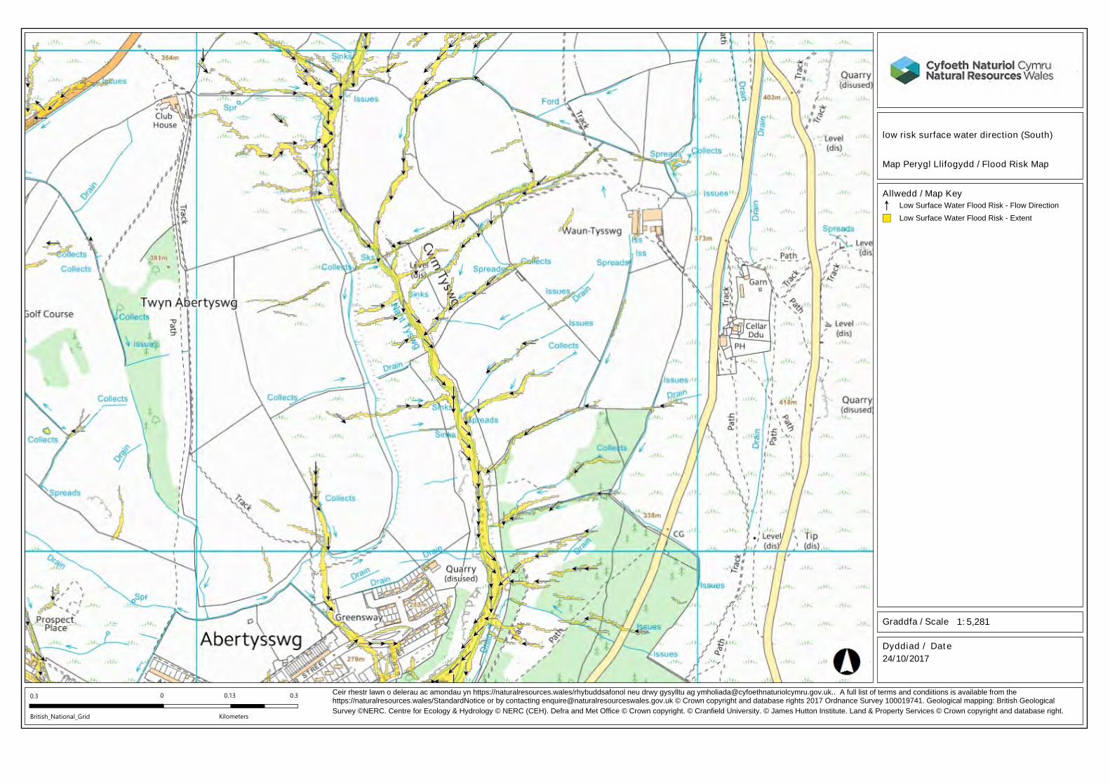
flow direction (Appendix 2) within the application area runs from east to west discharging into the Nant Tyswg.
4.8 Historical flood events
NRW historical flood mapping indicates the application area has not flooded historically. 4.8.1
4.9 Current Flood Risk
NRW TAN 15 DAM indicates that the whole site is located in Zone A, defined as areas 4.9.1
considered to be at little or no risk of fluvial or coastal/tidal flooding.
NRW surface water flood mapping indicates that the majority of the site is at ‘very low’ risk of 4.9.2
flooding. Localised areas within the application area associated with field drains are defined as
being at low to high risk of surface water flooding.
Site

JER1377 – Wauntysswg Solar Farm 11 March 2018
rpsgroup.com/uk
5 Development Impacts
5.1 Introduction
PPW and TAN 15 outlines that developments have the potential to introduce impermeable areas 5.1.1
to land was previously relatively permeable. As a consequence runoff rates may increase altering hydrological characteristics, which could in turn increase flood risk and potentially affect
ecology and/or habitats.
Modelling work (Cook and McCuen 2013) shows that solar panels themselves do not have a 5.1.2
significant effect on runoff volumes, peak flows or times to peak. However, where design
decisions or lack of maintenance lead to bare ground then the peak discharge may increase
significantly requiring storm water management.
5.2 Effects of solar panel arrays on runoff
Panel Runoff
The impact of the solar panels is to focus runoff onto the ground below the leading edge. 5.2.1
The runoff has kinetic energy by virtue of the water falling from the edge of the panel and onto 5.2.2
the ground, and research has found this to be greater than that of the rainfall (e.g. Cook and McCuen 2013). The falling water can cause kinetic compaction and also splash erosion
particularly on bare or poorly vegetated soils. The risk of compaction/erosion is a function of the
runoff velocity, the falling velocity achieved (dependent on fall distance from leading edge to the
ground), the soil texture and the vegetation type/ percentage of vegetation cover.
Ground infiltration/ runoff
Once on the ground the water will infiltrate naturally into the soil cover, or if runoff rates exceed 5.2.3
infiltration rates (for example in heavy clay soils or compacted soils) will flow downslope by virtue of existing contours. In addition solar panels may cause a shadow effect potentially
reducing available infiltration area.
UK solar parks typically comprise rows of panel arrays with a separation distance of a few 5.2.4
metres between each row as in Figure 3. This provides the opportunity for runoff from the panel
rows to be both filtered through the vegetation to reduce erosion, infiltrate into both the open
inter-row soils and also the drier sheltered soils in the rain shadow zone of the down slope panel
row.
Each solar panel/panel array shelters the ground beneath causing a rain shadow effect. The 5.2.5only significant means of rainfall reaching the ground beneath the panels is by runoff from the
ground upslope as shown in Figure 3.

JER1377 – Wauntysswg Solar Farm 12 March 2018
rpsgroup.com/uk
Figure 3 - Typical Solar Panel installation
There is no UK environmental guidance for managing runoff from solar panel installations. US 5.2.6
guidance, for example Maryland Department for the Environment Storm water Design Guidance
for solar panel installations (MDE 2010) recommends ‘non-structural techniques like
disconnecting impervious cover’ to reduce runoff by promoting overland filtering and infiltration. However, a number of factors also need to be considered:
The vegetated area receiving runoff must be equal to or greater in length than the
disconnected surface (e.g., width of the row of solar panels).
Runoff must sheet flow onto and across vegetated areas to maintain the disconnection.
Disconnections should be located on gradual slopes (≤ 5%) to maintain sheet flow. Level
spreaders, terraces, or berms may be used to maintain sheet flow conditions if the average
slope is steeper than 5%. However, installations on slopes greater than 10% will require an
engineered plan that ensures adequate treatment and the safe and non-erosive conveyance of runoff to the site boundary, or downstream storm water management practice.
Disconnecting impervious surfaces works best in undisturbed soils. To minimize disturbance
and compaction, construction vehicles and equipment should avoid areas used for
disconnection during installation of the solar panels. Where disturbance is unavoidable, post
construction soil treatment (tilled / scarified) to restore soil condition may be required.
Groundcover vegetation must be maintained in good condition in those areas receiving
disconnected runoff. Typically this maintenance is no different than other lawn or landscaped areas. However, areas receiving runoff should be protected (e.g., planting
shrubs or trees along the perimeter) from future compaction.
Cook and McCuen 2013 recommend that the vegetation cover beneath the panels is well 5.2.7
maintained or that a buffer strip be placed after the most down gradient row of panels.

JER1377 – Wauntysswg Solar Farm 13 March 2018
rpsgroup.com/uk
5.3 Hydrological / Ecological
Unmitigated effects as a consequence of the development may result in an alteration to current 5.3.1
hydrological characteristics leading to an increase in runoff, as described in Section 5.2. In addition the unmitigated development may also alter drainage patterns within the application
area, which may lead to the loss or degradation of habitats within the designated sites (Habitats
A & E-H Drawing 3).
Appendix 3 shows the estimated surface water flow pathways based on NRW 2 m resolution 5.3.2
DTM LiDAR data. The figure shows a general west-southwest flow pathway following the natural
land contours.
The percentage increase in impermeable area is negligible and ordinarily would not require any 5.3.3surface water management scheme (Cook and McCuen 2013). Appropriately managed runoff
from the application site would not be increased by the presence of solar panels.
The solar park design, as well as surface water and soil management measures outlined below 5.3.4
(Section 6) will ensure that there is no alteration to local drainage patterns direction within the
application area and there are no increases in suspended sediments within the drainage
channels or surface water runoff. The ecological nature of the designated habitats within the
application area, including habitat A within the southern extent of the site, would not be affected
by the proposed development.
The development design has allowed for no solar panel installation within habitat A along the 5.3.5
southern extent of the site. The surface water and soil management measures including design-
in prevention) techniques and appropriately maintained vegetation across the entire site will
direct runoff to ecologically beneficial habitat areas to maintain the natural drainage regime.

JER1377 – Wauntysswg Solar Farm 14 March 2018
rpsgroup.com/uk
6 Surface Water and Soil Management
6.1 Introduction
The nature of the development means that precipitation would be intercepted by the solar 6.1.1
panels and associated infrastructure and where inappropriately managed potentially effected existing hydrological characteristics increasing surface water flow.
The runoff quality from the panels will be clean and poses a low environmental risk. It has been 6.1.2
assumed that any additional foul/industrial waste from the construction, maintenance and
operation and decommissioning of the park will be disposed of offsite.
In the absence of an appropriate site management strategy kinetic compaction and rivulet 6.1.3
formation / concentrated runoff could lead to the development of an integrated drainage network
within the field, which can bypass soil storage and rapidly convey flow off-site into the receiving
watercourse.
Ground conditions (wet/ waterlogged) soils during the winter months at the site may not be 6.1.4
suitable to allow uncontrolled run-off from the panels and from the ancillary buildings directly to
the ground in the absence of a vegetation cover.
To minimise the potential impacts from soil compaction and changes in flow pathways a number 6.1.5
of mitigation techniques have been suggested (Section 6.3).
6.2 Sustainable Drainage Systems (SuDS)
The PPW and associated TAN15, CIRIA C753 SUDS Manual (2015) and also the Blaenau 6.2.1Gwent County Borough Council preliminary planning advice promotes sustainable water
management through the use of SuDS. A hierarchy of techniques is identified:
Prevention – the use of good site design and housekeeping measures on individual sites to prevent runoff and pollution (e.g. minimise areas of hard standing).
Source Control – control of runoff at or very near its source (such as the use of rainwater
harvesting).
Site Control – management of water from several sub-catchments (including routing water
from roofs and car parks to one/several large soakaways for the whole site).
Regional Control – management of runoff from several sites, typically in a detention pond or
wetland.
The implementation of SuDS as opposed to conventional drainage systems, provides several 6.2.2benefits by:
Reducing peak flows to watercourses or sewers and potentially reducing the risk of flooding
downstream;

JER1377 – Wauntysswg Solar Farm 15 March 2018
rpsgroup.com/uk
Reducing the volumes and frequency of water flowing directly to watercourses or sewers
from developed sites;
Improving water quality over conventional surface water sewers by removing pollutants from
diffuse pollutant sources;
Reducing potable water demand through rainwater harvesting;
Improving amenity through the provision of public open spaces and wildlife habitat; and
Replicating natural drainage patterns, including the recharge of groundwater so that base flows are maintained.
The introduction of SuDS, where required, within the application site will work in conjunction with 6.2.3
existing field drainage to manage the discharge of water from the site. The SuDS techniques will
include measures to remove any potential suspended sediments caused by soil erosion.
The drains and SuDS will be maintained by the client for the life of the project. 6.2.4
6.3 Soil Management Measures
To meet soil protection guidance, PPW and TAN15 objectives to reduce surface water flood risk, 6.3.1where appropriate, SuDS runoff control measures are recommended.
Soil compaction will be limited during the construction phase by a number of measures; 6.3.2
Only light machinery will be used to install the solar panels and low ground pressure
vehicles will be used during extreme rainfall events. Where construction has resulted in soil compaction, the areas between panel rows would be
tilled / scarified to an appropriate depth and then re-seeded with an appropriate vegetation
cover.
During operation, maintenance of infrastructure will be limited and only require light
machinery, therefore no change in the existing permeability of the soil would be caused.
The presence of appropriate maintained vegetation at all times across the application site will 6.3.3
mitigate potential increases in runoff and soil erosion, which can be a contributing factor to
greater runoff.
Any existing field or tile drainage system would be restored where affected by construction. 6.3.4
All tracks and access roads will be made out of permeable material (Gravel or reinforced grass) 6.3.5
reducing any potential increase in runoff.

JER1377 – Wauntysswg Solar Farm 16 March 2018
rpsgroup.com/uk
7 Off-site Impacts and Residual Risks
Incorporation of one or more runoff management techniques will have a positive impact upon 7.1.1
field drainage and there will be limited impacts on off-site surface water receptors.
The proposed development would maintain the existing rates of runoff, reduce the risk of 7.1.2
nutrient or pesticide wash off on soil particulates thereby improving water quality in the receiving
watercourse, and also contribute to maintenance of the natural drainage regime.
For extreme events the site topography will convey exceedance flows overland towards the 7.1.3
western boundary of the site in line with natural drainage patterns. It is therefore considered that
the proposed development would have negligible effects on ecological sensitive sites.
In summary, provided suitable soil management measures and SuDS techniques through 7.1.4
Prevention are incorporated into the design, the proposed development would have negligible
effect on flood risk onsite or elsewhere, would preserve the application site’s natural drainage
regime and cause retaining flows to existing ecologically sensitive habitats.

JER1377 – Wauntysswg Solar Farm 17 March 2018
rpsgroup.com/uk
8 Summary and Conclusions
8.1 Summary
A site-specific hydrological assessment cognisant of the TAN15 and PPW has been undertaken 8.1.1
for a prospective 30 MW solar park and ancillary development at Wauntysswg Farm at Abertysswg, Rhymney, Tredegar NP22 5BQ.
8.2 Flood Risk
NRW TAN 15 DAM indicates that the whole site is located in Zone A, defined as areas 8.2.1considered to be at little or no risk of fluvial or coastal/tidal flooding.
NRW surface water flood mapping indicates that the majority of the site is at ‘very low’ risk of 8.2.2
flooding. Localised areas within the application area associated with low lying land and field
drains are defined as being at low to high risk of surface water flooding
The susceptibility to groundwater flooding is low. 8.2.3
The risk of flooding from reservoir failure has been assessed as low. 8.2.4
8.3 Hydrological Appraisal
The surface water flow pathways are all estimated to flow in a west-southwest direction following 8.3.1
the downward slope of the natural contours.
The percentage increase in impermeable area is negligible and ordinarily would not require any 8.3.2
surface water management scheme. The incorporation of appropriate management techniques will mitigate potential increase in runoff from the solar park site.
The solar park design, as well as surface water and soil management measures outlined will 8.3.3
ensure that there is negligible alteration to local drainage patterns and flow directions, and
manage suspended sediments from entering the drainage channels.
8.4 Surface Water and Soil Management Measures
SuDS techniques through design-in Prevention will be incorporated into the final design, where 8.4.1required, and will work in conjunction with existing field drainage to manage the discharge of any
excess water from the site.
Where construction has resulted in soil compaction, the areas between panel rows would be 8.4.2
tilled / scarified to an appropriate depth and then re-seeded with an appropriate vegetation cover.
All areas of the application area, where appropriate, will have vegetation cover at all times. 8.4.3
Any existing field or tile drainage system will be restored, where affected by construction will be 8.4.4
maintained by the client for the life of the development.
JER1377 – Wauntysswg Solar Farm 18 March 2018
rpsgroup.com/uk
Tracks and access road will be constructed out of permeable materials (Gravels or Reinforced 8.4.5
grass).
8.5 Conclusion
The hydrological assessment demonstrates that: 8.5.1
The application site is at very low risk of flooding from fluvial and/or tidal flooding.
It would neither exacerbate existing flooding problems nor increase the risk of flooding on
site or elsewhere.
Surface water runoff will be mitigated by maintenance of a grazed vegetation cover and
storage measures;
With appropriate surface water and soil management measures there is negligible alteration to local drainage patterns direction within the application area;
The development would cause negligible adverse effects on local sensitive ecological areas.
In summary the proposed development is at low risk of flooding and with appropriate surface 8.5.2
water and soil management measures would cause negligible effects on the hydrological
regimes and ecological sensitive habitats.

JER1377 – Wauntysswg Solar Farm 19 March 2018
rpsgroup.com/uk
References
BGS (Online), Geology of Britain Viewer. Available at: http://mapapps.bgs.ac.uk/geologyofbritain/home.
Burch T., Armstrong A., Rose S., and Maslen S. 2014 Impact of solar parks on runoff generation and
associated land drainage/flood risk consequences. Presentation to British Hydrological Society 5th June
2014.
CIRIA Report C532. Control of Water Pollution from Construction Sites.
CIRIA Report C741 Environmental Good Practice on Site.
CIRIA Report C753 (2015) The SuDS manual.
Cook L.M. and McCuen R.H. 2013 Hydrologic Response of Solar Farms, J. Hydrologic Engineering 18: 536-541.
DEFRA, October 2006. Flood and Coastal Defence Appraisal Guidance FCDPAG4 Economic Appraisal
Supplementary, Note to Operating Authorities – Climate Change Impacts.
DEFRA, December 2011. National Standards for sustainable drainage systems. Designing, constructing,
operating and maintaining drainage for surface runoff.
MDE 2009 Maryland Stormwater Design Manual Volumes 1 and 2, Maryland Department of the
Environment 2009.
Natural England (Online), Magic Map. Available at: http://www.magic.gov.uk/.
Ordnance Survey Explorer (2012) 1:50,000 Map 161: The Black Mountains.
Ordnance Survey 1:10,000 Scale Electronic Data Mapping for assessment area.
RPS, March 2018. Wauntysswg Solar Farm, Ecological Mitigation Plan.
UK Climate Projections science report: Climate change projections, Version 3, updated December 2010.
Welsh Government, November 2016. Planning Policy Wales, Edition 9.
Welsh Government, July 2004. Planning Policy Wales, Technical Advice Note 15: Development and
Flood Risk.

JER1377 – Wauntysswg Solar Farm 20 March 2018
rpsgroup.com/uk
Drawings
Drawing 1 Site Location Plan / Existing Site Layout
Drawing 2 Proposed Development Layout
Drawing 3 Ecological Sensitive Area

B
4
2
5
6
C
H
A
R
L
E
S
S
T
R
E
E
T
Client
Title
Status
Date CreatedScale @ A0
PM/Checked byDrawn By
Drawing NumberRev
Project
Job Ref
rpsgroup.com/uk
c 2016 RPS Group
Notes
1. This drawing has been prepared in accordance with the scope of RPS’s
appointment with its client and is subject to the terms and conditions of that
appointment. RPS accepts no liability for any use of this document other than
by its client and only for the purposes for which it was prepared and provided.
2. If received electronically it is the recipients responsibility to print to correct scale.
Only written dimensions should be used.
Park House, Greyfriars Road,
Cardiff, CF10 3AF
T: +44(0)2920668662 E: [email protected] F: +44(0)2920 668622
ELGIN ENERGY EsCo
WAUNTYSSWG PV
DNS SITE APPLICATION PLAN
PLANNING GG AL
JPW0888 1:2500
MAY 2018
JPW0888-DNS-005 -
Rev Description Date Initial Checked
A Amended Red Line Boundary 01-02-17 GG AL
B Amended Red Line Boundary 27-11-17 GG AL
© Crown copyright, All rights reserved. 2018 License number 0100031673
LEGEND
APPLICATION BOUNDARY
LAND WITHIN THE APPLICANTS CONTROL

1.65-1.95m
1.65-1.95m
S
O
L
A
R
A
N
G
L
E
O
F
1
5
°
GROUND SLOPE VARIES
25.0°
2 PANEL IN PORTRAIT
ORIENTATION
POST EMBEDMENT TBC
(CIRCA 1.5m)
0.8m Min.
2m-6m
2.4m-3m
S
O
L
A
R
A
N
G
L
E
O
F
1
6
°
N
DUE SOUTH MODULE
ORIENTATION
T
IC
IC
T
IC
IC
T
I
C
I
C
T
I
C
I
C
T
I
C
I
C
T
I
C
I
C
T
I
C
I
C
T
I
C
I
C
T
I
C
I
C
T
I
C
I
C
T
I
C
I
C
T
I
C
I
C
T
I
C
I
C
T
I
C
I
C
T
I
C
I
C
T
I
C
I
C
T
I
C
I
C
T
I
C
I
C
T
I
C
I
C
T
I
C
I
C
T
I
C
I
C
T
I
C
I
C
T
I
C
I
C
T
I
C
I
C
T
I
C
I
C
SITE ACCESS POINT
DNO Substation
Client Substation
15m Lattice Tower
Restricted Byway
Proposed Restricted
Byway Diversion
SITE COMPOUND, CAR PARKING AND TURNING AREA
Timber Post TensionerTension Spring
HT Tension wires
Hi-Tensile Wire Mesh
Client
Title
Status
Date CreatedScale @ A0
PM/Checked byDrawn By
Drawing NumberRev
Project
Job Ref
rpsgroup.com/uk
c 2016 RPS Group
Notes
1. This drawing has been prepared in accordance with the scope of RPS’s
appointment with its client and is subject to the terms and conditions of that
appointment. RPS accepts no liability for any use of this document other than
by its client and only for the purposes for which it was prepared and provided.
2. If received electronically it is the recipients responsibility to print to correct scale.
Only written dimensions should be used.
Park House, Greyfriars Road,
Cardiff, CF10 3AF
T: +44(0)2920668662 E: [email protected] F: +44(0)2920 668622
ELGIN ENERGY EsCo
WAUNTYSSWG PV
SITE LAYOUT PLAN
PLANNING GG AL
JPW0622 1:2000
MARCH 2016
JPW0622-WAU-002 I
Rev Description Date Initial Checked
A Revised layout 30-01-17 GG AL
B Amended Layout with updated topo 21-02-17 GG AL
© Crown copyright, All rights reserved. 2017 License number 0100031673
LEGEND
SITE BOUNDARY
HALF SOLAR PANEL
FULL SOLAR PANEL
3.5m ACCESS TRACK
INVERTER SUBSTATION
5m STANDOFF FROM
WATERCOURSE / HEDGE
CABLE ROUTE
SECURITY FENCE
T
I
C
I
C
C Amended red line, cable route and road access 30-03-17 GG AL
D
Relocation of Sub Station 15-06-17 GG AL
E
Removal of panels to the south 31-10-17 GG AL
F
Addition of panels 16-11-17 GG AL
G
Addition of Lattice tower and PROW 29-11-17 GG AL
TYPICAL INVERTOR SUBSTATION ABB PYS800-MWS SHOWN
DIMENSIONS: 7m x 2.5m x 3m HIGH. ALL SUBJECT TO FINAL DESIGN
PROPOSED LATTICE TELECOMS TOWER
TYPICAL ONE USED IS SLP2
H
Additional track and layout change 06-02-18 GG AL
I
Addition of Compound car parking & turning area 01-07-18 GG AL


JER1377 – Wauntysswg Solar Farm March 2018
rpsgroup.com/uk
Appendices

JER1377 – Wauntysswg Solar Farm March 2018
rpsgroup.com/uk
Appendix 1
Topography

206160N206160N
206180N206180N
206200N206200N
206220N206220N
206240N206240N
206260N206260N
206280N206280N
206300N206300N
206320N206320N
206340N206340N
206360N206360N
206380N206380N
206400N206400N
206420N206420N
206440N206440N
206460N206460N
206480N206480N
206500N206500N
206520N206520N
206540N206540N
206560N206560N
206580N206580N
206600N206600N
206620N206620N
206640N206640N
206660N206660N
206680N206680N
206700N206700N
206720N206720N
206740N206740N
206760N206760N
206780N206780N
206800N206800N
206820N206820N
206840N206840N
206860N206860N
206880N206880N
206900N206900N
206920N206920N
206940N206940N
206960N206960N
206980N206980N
207000N207000N
207020N207020N
207040N207040N
207060N207060N
207080N207080N
207100N207100N
207120N207120N
207140N207140N
207160N207160N
207180N207180N
207200N207200N
207220N207220N
207240N207240N
207260N207260N
207280N207280N
207300N207300N
207320N207320N
207340N207340N
207360N207360N
207380N207380N
207400N207400N
207420N207420N
207440N207440N
207460N207460N
207480N207480N
207500N207500N
207520N207520N
3132
80E
3133
00E
3133
20E
3133
40E
3133
60E
3133
80E
3134
00E
3134
20E
3134
40E
3134
60E
3134
80E
3135
00E
3135
20E
3135
40E
3135
60E
3135
80E
3136
00E
3136
20E
3136
40E
3136
60E
3136
80E
3137
00E
3137
20E
3137
40E
3137
60E
3137
80E
3138
00E
3138
20E
3138
40E
3138
60E
3138
80E
3139
00E
3139
20E
3139
40E
3139
60E
3139
80E
3140
00E
3140
20E
3140
40E
3140
60E
3140
80E
3141
00E
3141
20E
©2016 Usk Land Survey. All rights Reserved

JER1377 – Wauntysswg Solar Farm March 2018
rpsgroup.com/uk
Appendix 2
NRW Surface Water Direction Flood Risk Map

British_National_Grid
Ceir rhestr lawn o delerau ac amondau yn https://naturalresources.wales/rhybuddsafonol neu drwy gysylltu ag [email protected].. A full list of terms and condiitions is available from the https://naturalresources.wales/StandardNotice or by contacting [email protected] © Crown copyright and database rights 2017 Ordnance Survey 100019741. Geological mapping: British Geological
Survey ©NERC. Centre for Ecology & Hydrology © NERC (CEH). Defra and Met Office © Crown copyright. © Cranfield University. © James Hutton Institute. Land & Property Services © Crown copyright and database right.
1: 5,281
Dyddiad / Date
24/10/2017
low risk surface water direction
Allwedd / Map Key
Map Perygl Llifogydd / Flood Risk Map
Graddfa / Scale
0.30.3 0
Kilometers
0.13
Low Surface Water Flood Risk - Flow Direction
Low Surface Water Flood Risk - Extent
British_National_Grid
Ceir rhestr lawn o delerau ac amondau yn https://naturalresources.wales/rhybuddsafonol neu drwy gysylltu ag [email protected].. A full list of terms and condiitions is available from the https://naturalresources.wales/StandardNotice or by contacting [email protected] © Crown copyright and database rights 2017 Ordnance Survey 100019741. Geological mapping: British Geological
Survey ©NERC. Centre for Ecology & Hydrology © NERC (CEH). Defra and Met Office © Crown copyright. © Cranfield University. © James Hutton Institute. Land & Property Services © Crown copyright and database right.
1: 5,281
Dyddiad / Date
24/10/2017
low risk surface water direction (South)
Allwedd / Map Key
Map Perygl Llifogydd / Flood Risk Map
Graddfa / Scale
0.30.3 0
Kilometers
0.13
Low Surface Water Flood Risk - Flow Direction
Low Surface Water Flood Risk - Extent

JER1377 – Wauntysswg Solar Farm March 2018
rpsgroup.com/uk
Appendix 3
DTM Flow Pathway Assessment Map
