waterfront transit network plan - city of toronto · 1. city council endorse the overall waterfront...
TRANSCRIPT

Waterfront Transit Network Plan Page 1 of 23
REPORT FOR ACTION
Waterfront Transit Network Plan
Date: January 10, 2018 To: Executive Committee From: Deputy City Manager, Cluster B Wards: 5, 6, 13, 14, 19, 20, 28, 30, 32
SUMMARY
This report was prepared in collaboration with the Toronto Transit Commission (TTC) and Waterfront Toronto.
The goal of this study was to create a waterfront transit network from Long Branch and Lake Shore in the west to Queen Street and Woodbine Avenue in the east. The results of the study and latest travel demand forecast confirmed the direction of previous initiatives to create an exclusive streetcar right-of-way (LRT) from Legion Road and Lake Shore Boulevard in the west to Leslie Street and Commissioners Street in the east. This direction is consistent with land use projections to 2041 where it was found that the waterfront will outpace most other areas of the City and Region in terms of growth.
In this report, solutions are being advanced for key sections of the network between Humber Bay Shores and Exhibition Place, along Bathurst St from Fort York Blvd to Queens Quay, and for the Port Lands from Parliament St to Leslie St.
The study has defined the primary east-west waterfront transit corridor as a component of a connected transit and multi-modal system that supports significant growth areas, the greatest concentration of cultural, recreational and special events in the City, and also provides flexibility and network resilience. As a result, a series of streetcar infrastructure projects are recommended that will support a range of route and service options that will allow different future demands to be served.
The two most significant projects in the network are the westerly extension of a new exclusive LRT right-of-way from Exhibition Place to serve the Humber Bay Shores area ("Humber Bay Link"), and improving the underground transit link from Union Station to Queens Quay, including the previously approved exclusive LRT right-of-way along Queens Quay East. Without these two components of the network, the benefits of further transit improvements to the west and the east cannot be fully realized.
The 30% design is already underway for a first phase of the westerly extension of the exclusive transit right-of-way to Humber Bay Shores. This is the section of the network between the Exhibition Loop and the Dufferin Gate Loop, and the next steps are to
EX30.1

Waterfront Transit Network Plan Page 2 of 23
complete the design and build the infrastructure. This interim extension to the Dufferin Gate Loop has the added benefit of linking the waterfront line to the existing light rail lines on King Street and Queen Street. The initiation of planning for the Humber Bay Link will proceed based on the advancing design of the interim extension. The underground transit link along Bay Street from Union Station to Queens Quay remains the most critical and challenging section in the network, due to transit ridership volumes, costs and construction challenges. Options have been narrowed down to expanding light rail capacity at Union Station, or repurposing the existing underground link with an automated dual-haul funicular transit system. These two options are recommended for continued feasibility assessment, and thereafter to quickly proceed to detailed design for a preferred solution by Q2 2019 or sooner. The recommended direction for transit infrastructure improvements across the waterfront network is summarized schematically in Figure 1 below, and will be included in the City's update to the Official Plan in 2018, subject to approval. Services to be operated would be approved by the TTC Board at a later date, when the infrastructure is ready.
Figure 1: Recommended Waterfront Transit Network Improvements
Waterfront Transit Network Plan Page 3 of 23
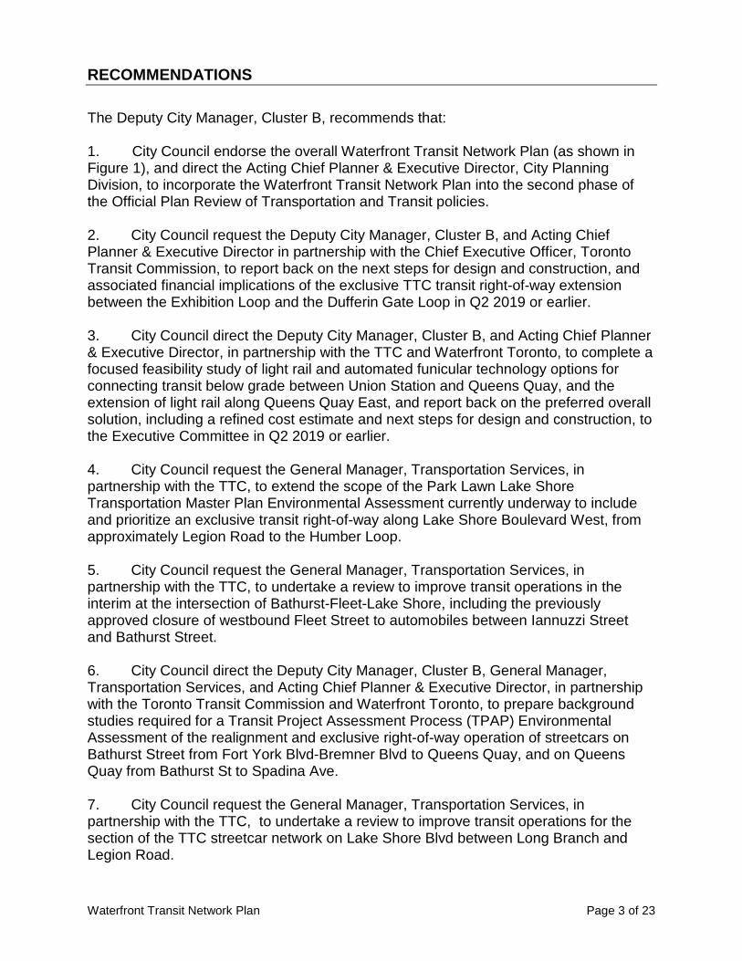
RECOMMENDATIONS The Deputy City Manager, Cluster B, recommends that: 1. City Council endorse the overall Waterfront Transit Network Plan (as shown in Figure 1), and direct the Acting Chief Planner & Executive Director, City Planning Division, to incorporate the Waterfront Transit Network Plan into the second phase of the Official Plan Review of Transportation and Transit policies. 2. City Council request the Deputy City Manager, Cluster B, and Acting Chief Planner & Executive Director in partnership with the Chief Executive Officer, Toronto Transit Commission, to report back on the next steps for design and construction, and associated financial implications of the exclusive TTC transit right-of-way extension between the Exhibition Loop and the Dufferin Gate Loop in Q2 2019 or earlier. 3. City Council direct the Deputy City Manager, Cluster B, and Acting Chief Planner & Executive Director, in partnership with the TTC and Waterfront Toronto, to complete a focused feasibility study of light rail and automated funicular technology options for connecting transit below grade between Union Station and Queens Quay, and the extension of light rail along Queens Quay East, and report back on the preferred overall solution, including a refined cost estimate and next steps for design and construction, to the Executive Committee in Q2 2019 or earlier. 4. City Council request the General Manager, Transportation Services, in partnership with the TTC, to extend the scope of the Park Lawn Lake Shore Transportation Master Plan Environmental Assessment currently underway to include and prioritize an exclusive transit right-of-way along Lake Shore Boulevard West, from approximately Legion Road to the Humber Loop. 5. City Council request the General Manager, Transportation Services, in partnership with the TTC, to undertake a review to improve transit operations in the interim at the intersection of Bathurst-Fleet-Lake Shore, including the previously approved closure of westbound Fleet Street to automobiles between Iannuzzi Street and Bathurst Street. 6. City Council direct the Deputy City Manager, Cluster B, General Manager, Transportation Services, and Acting Chief Planner & Executive Director, in partnership with the Toronto Transit Commission and Waterfront Toronto, to prepare background studies required for a Transit Project Assessment Process (TPAP) Environmental Assessment of the realignment and exclusive right-of-way operation of streetcars on Bathurst Street from Fort York Blvd-Bremner Blvd to Queens Quay, and on Queens Quay from Bathurst St to Spadina Ave. 7. City Council request the General Manager, Transportation Services, in partnership with the TTC, to undertake a review to improve transit operations for the section of the TTC streetcar network on Lake Shore Blvd between Long Branch and Legion Road.

Waterfront Transit Network Plan Page 4 of 23
8. City Council direct the Deputy City Manager, Cluster B & Acting Chief Planner & Executive Director, City Planning, in partnership with the Toronto Transit Commission, to prepare background studies required for a Transit Project Assessment Process (TPAP) Environmental Assessment of a new exclusive transit right-of way from Colborne Lodge Drive and The Queensway to Dufferin Street at the Dufferin Gate, as per the preferred route identified in the report dated January 10, 2018 entitled Waterfront Transit Network Plan. 9. City Council direct the Acting Chief Financial Officer to include eligible components of the Waterfront Transit project in the City's development charges bylaw review currently underway. 10. City Council direct the City Manager to forward this report to Metrolinx for consideration in the ongoing review of the Regional Transportation Plan for 2041.
FINANCIAL IMPACT Initial preliminary (pre-design) cost estimate for completion of the entire Waterfront Transit Network are in the range of $1.980 billion to $2.310 billion in 2017 dollars. These costs are primarily based on 1% or less level of design, and do not include rolling stock. This estimate is subject to further design work, third party cost estimate validation, and availability of federal and provincial funding. This estimate does not include escalation, financing costs or the pricing of risk. The Waterfront Transit Network is included in the Waterfront Revitalization Initiative capital budget as an unfunded project. In 2017 City Council approved a 10-Year Capital Budget and Plan that includes $3.6 million in funding to complete 30% design of the TTC transit right-of-way extension between the Exhibition Loop and the Dufferin Gate Loop. $1.8 million of the project funding has been secured through the Federal Public Transit Infrastructure Fund (PTIF) program (Phase 1). In keeping with the PTIF guidelines, this project must be complete by March 31, 2019. In addition as per Council decision during its meeting of November 7, 2017, the budget for was transferred from the City to the TTC. The Waterfront Transit Network was identified by Council as a priority project for Federal Public Transit Infrastructure Fund (PTIF) Phase 2 (EX20.4). The Integrated Bilateral Agreements (IBAs) between the Federal Government and the province and territories are on-going, and expected to conclude by March 2018. Once the Canada-Ontario IBA and program details are finalized, the City will review the eligibility of Council identified priority projects, including the Waterfront Transit Network Plan, based on the program criteria. Funding in the amount of $250,000 is available from the Waterfront Revitalization Initiative, capital project CWR003-10, for retaining consulting services to assist the City in completing a focused feasibility study of light rail and automated funicular technology options for connecting transit below grade between Union Station and Queens Quay, and the extension of light rail along Queens Quay East. Staff will also explore other intergovernmental sources of funding to advance the planning and design for the Waterfront Transit Network Plan, including PTIF, so that the project cost estimates may

Waterfront Transit Network Plan Page 5 of 23
be refined to a Class 3 level in accordance with the Stage Gate Process and necessary for Council to confirm its definitive commitment to the project. Land development and redevelopment requires the provision of municipal infrastructure so that municipal services are provided to new population and employment. Development Charges are one-time, upfront fees levied on land development projects under the provincial Development Charges Act, 1997 (DCA). The revenues from these charges help fund a portion of the growth-related share of capital costs, consistent with the principle that growth should pay for growth. It is noted that DCs do not fully pay for growth related infrastructure costs due to legislative restrictions and Council adopted policy discounts and a portion of the costs must be funded from other funding sources. This report recommends that eligible costs be included in the development charges background study currently being prepared, which will form the basis for an updated development charges rates and bylaw. All funding strategies and associated capital and operating costs associated with the Waterfront Transit Network will be reviewed as part of future year Operating and Capital Budget and Plan submissions and considered against other unfunded City priorities. The Acting Chief Financial Officer has reviewed this report and concurs with the financial impact information.
DECISION HISTORY The following Council decisions link to Waterfront Transit Network planning: On November 3, 4, 2015, City Council directed City staff in consultation with the TTC and Waterfront Toronto to undertake a Phase 1 comprehensive review of waterfront transit initiatives and options. This review process was named the "Waterfront Transit Reset". Link: EX9.9 Waterfront Transit Reset On July 12-15, 2016, City Council directed City staff to initiate a second phase of the Waterfront Transit "Reset" for further development and costing of alignment concepts, detailed analysis of transit operations and ridership, identification of priority segments, as well as the creation of a Business Case and implementation strategy for delivering a coordinated waterfront transit solution. Council further directed staff to move to 30% design for the extension of the exclusive streetcar network from the Exhibition Loop to the Dufferin Gate Loop. Link: EX16.17 Waterfront Transit Network Vision
COMMENTS 1. Background and Study Area Phase 1 of the Waterfront Transit "Reset" was completed in 2016. The primary study area for Phase 1 included between Long Branch in the west and Woodbine Avenue in
Waterfront Transit Network Plan Page 6 of 23
the east, and south of The Queensway/Queen St corridor to Lake Ontario. The Phase 1 study established a new vision for guiding waterfront transit network planning: "Provide high quality transit that will integrate waterfront communities, jobs, and destinations and link the waterfront to the broader City and regional transportation network." Key outcomes of the Phase 1 study were the identification of existing travel demands, projected population and employment growth to 2041, transit planning objectives, a tailored evaluation framework consistent with the City's Rapid Transit Project Evaluation Framework, and the initial development of a suite of transit improvement concepts that could be further evaluated. The Phase 1 study found that population in the study area for the period 2011-2041 is projected to increase by approximately 280,000 (83%), and employment growth for the same period is anticipated to increase by approximately 190,000 new jobs (38%). The projected growth will outpace most other areas of the City and Region, and these projections are included in the travel demand forecast completed for Phase 2. The scope of work for the Phase 2 study was developed based on the outcomes of the Phase 1 study. The findings of the scope of work for the Phase 2 study are the subject of this report, and are provided in the sections to follow. For Phase 2, the primary study area included between Long Branch in the west and Woodbine Avenue in the east, including Lake Shore Boulevard to the west of the Humber River, and the area south of the Queensway/Queen Street corridor to the east of the Humber River. The Waterfront Transit "Reset" has been led by City Planning, in partnership with the TTC and Waterfront Toronto. Metrolinx and the City of Mississauga have been consulted during the course of study. Another key outcome of the Phase 1 study was a request of Council to approve funding for 30% design for the extension of the exclusive streetcar network from the Exhibition Loop to the Dufferin Gate Loop. This work is now underway, being led by the TTC. 2. Travel Demand Travel demand forecasting completed for the Phase 2 study confirmed that light rail transit technology will support future transit demand along the waterfront between Long Branch and Leslie St to the 2041 horizon year. The forecasting confirmed previous study findings that the existing TTC transit network infrastructure in many areas along the waterfront is inadequate to accommodate latent and future transit demands based on significant projected population and employment growth. These areas include Union Station-East Bayfront-Lower Don Lands-Port Lands, Liberty Village–Exhibition Place, and Humber Bay Shores. Improvements to transit in the Union Station-East Bayfront area, Humber Bay Shores, and the Exhibition Place - Liberty Village area in particular should be prioritized and accelerated over other areas of the network.

Waterfront Transit Network Plan Page 7 of 23
The forecasting revealed that existing transit infrastructure in some other areas of the waterfront can generally accommodate latent and future transit demands to the year 2041. These areas include southwestern Etobicoke, and the western central waterfront between York Street and Bathurst Street. Because these areas are integral parts of an overall future network, they should be reviewed for operational improvements to further optimize network reliability. Operational improvements may include transit signal priority, turning restrictions, and improving transit connectivity to, and reducing potential conflict with, other transportation modes. At the east end of the study area, between Leslie Street and Woodbine Avenue, the forecasting revealed comparatively very low ridership within the 2041 timeframe. The forecasting revealed some overlap in demand between local and regional transit service for longer distance travel, particularly in the far western end of the study area. This is mainly because Lake Shore Boulevard transit and Lake Shore West Regional Rail are the only two higher-order east-west transit options within the geography. The City's regional transportation demand modelling tool (GTAModel v4), was used to help determine the future (2041) waterfront transit demand. The regional context is important in that it considers other major planned transit improvements including Metrolinx plans for GO service improvements, SmartTrack, the Relief Line subway east, and Broadview Ave and Cherry St LRT extensions, among others. The model also includes future projected growth in population and employment, and localized travel preferences. Fare integration is a long term strategy currently being refined and is not included in the modelling assumptions. The travel demand analysis revealed two key factors beyond forecast transit ridership. One, the greatest concentration of cultural, recreational and special event venues and destinations in the City is along the waterfront corridor. Trips to these destinations are not fully captured within the travel demand forecasts. Travel to these destinations occurs during peak and off-peak times, and has surging characteristics that periodically overwhelm the existing transportation network. Overall, it is realistic to assume that overall transit trips will be higher than forecast. Two, in addition to transit, the model suggests that pedestrian movements within the lower Bay Street Corridor will more than double within the 2041 horizon. This will result from growth in Union Station passenger volumes, and increasing population and employment density within the lower Bay Street corridor and Lower Yonge district. It is important that pedestrians and cyclists are considered in the further analysis of the lower Bay corridor as there can be mutual benefits for all of these travel modes. Overall, an extended TTC light rail transit service network along the waterfront would serve multiple roles – longer distance trips, local trips, recreational/cultural/special event-based trips, and connections to other sustainable transportation modes, providing a resilient and flexible transportation system for the 21st century.

Waterfront Transit Network Plan Page 8 of 23
3. Concept Screening There were 16 transit improvement concepts brought forward from the Phase 1 study (EX 16.17, Table 1), and these were screened according to Rapid Transit Evaluation Framework for Waterfront Transit. This screening considered key factors such as the Phase 2 travel demand forecasting and trend analysis, operational factors, and any updated information on other major projects in the study area since the completion of Phase 1. In general, 8 transit improvement concepts from the Phase 1 study passed the screening evaluation and were brought forward for further analysis and evaluation during Phase 2. The screening assessment can be found in Attachment 1. Wherever possible, the nomenclature established for transit concepts during Phase 1 was retained during Phase 2, and is used in the section below. 4. Evaluation, Analysis and Recommended Directions for Waterfront Transit Network Improvements This section summarizes the refinement, evaluation, and recommended directions for transit improvement options across the study area. A summary of the recommended directions is provided in Figure 2 below.
Figure 2: Recommended Waterfront Transit Network Improvements
Segment 1: Long Branch to Humber River West of Legion Road, the Lake Shore Boulevard West right-of-way varies considerably, and the forecasted transit demand is relatively low compared to other portions of the waterfront corridor. The corridor is also served by Long Branch and Mimico GO/Regional Express Rail stations, which tend to handle longer distance trips.

Waterfront Transit Network Plan Page 9 of 23
The recommended direction for west of Legion Road is to enhance or improve the existing mixed traffic streetcar operations on Lake Shore Boulevard, but not to create an exclusive transit right-of-way. Improving streetcar operations in this area may include a number of targeted initiatives, such as improving transit signal priority, improving interchanges at major north-south transit transfer points (e.g. Kipling/Lakeshore), and improving overall first/last mile multi-modal connectivity to the GO station(s). East of Legion Road, the Lake Shore Boulevard West right-of-way is generally wider and there is already significant and growing population & employment density. The transit demand through this area is higher than further west. The recommended direction for the Lake Shore Boulevard streetcar operation east of Legion Road is to implement an exclusive transit right-of-way. The exclusive transit right-of-way will be incorporated into the Park Lawn Lake Shore Transportation Master Plan Environmental Assessment (EA) as a priority improvement. The Park Lawn Lake Shore Transportation Master Plan will consider the broader transportation network in the area, the opportunity for a transit hub integrated with a potential new GO station, the redevelopment of the former Mr. Christies Site (2150 Lake Shore Blvd West), and increased active transportation connectivity. City Council has recently advised Metrolinx (MM34.3) that a new Park Lawn GO Station is a priority for the City of Toronto. The improvement of TTC infrastructure in this area combined with a new GO Station creates an opportunity for a sustainable transportation hub and aligns directly with the overall vision for waterfront transit. West of Long Branch, there is opportunity to improve transit service across the municipal border. Although beyond the scope of this study, Mississauga is currently undertaking a Transportation Master Plan for Lake Shore Road. Staff were actively consulting with Mississauga during the course of this study and acknowledged the importance of coordinating efforts on both sides of the border. Currently, both TTC and Miway services along the waterfront terminate at the Long Branch GO station. Transit forecasts completed for both municipalities point to future increasing demand for travel between south Etobicoke and South Mississauga, particularly as major population and employment growth in south Mississauga and the Hurontario Street LRT is realized. The analysis also showed a strong transit demand to the Humber College Campus at Kipling and Lake Shore, which helps to create a positive two-way travel pattern. The increase in demand for cross border trips is likely to be even further strengthened should a revised TTC-905 fare structure be implemented. Segment 2: Humber River to Strachan Avenue a) Humber Bay Link - Direction Summary The transit demand forecast for this section of the network identified the need to create an additional transit route to serve the Humber Bay area in particular. Without this additional route in the future, there are significant network challenges east of

Waterfront Transit Network Plan Page 10 of 23
Roncesvalles Avenue in the King and Queen Street corridors. The King Street transit priority pilot is primarily focused on immediate needs and latent demand, and does not negate the need for an additional transit route to the downtown. Three alternative LRT route concepts for this section of the network were further refined and evaluated according to the City's Rapid Transit Projects Evaluation Framework. The Concepts are described in Table 1. Table 1: Short Listed Humber Bay Link LRT Route Concepts
Concept Description
2A
From The Queensway/King/Queen/Roncesvalles Intersection and eastward along the Metrolinx Rail Corridor embankment, crossing the Rail Corridor and Gardiner Expressway on a new bridge west of Dunn Avenue, and connecting to Dufferin Street at the Dufferin Gate
2D From Lake Shore Boulevard in Humber Bay Shores, eastward along a new or expanded bridge across the Humber River, and continuing along Lake Shore Boulevard to Dufferin Street at the Dufferin Gate
2E
From The Queensway at Colborne Lodge Drive, south on Colborne Lodge Drive under the Metrolinx Rail Corridor and Gardiner Expressway in a designated pedestrian, cycling, and transit only roadway, and east along Lake Shore Boulevard, to Dufferin Street at the Dufferin Gate
Route Concept 2E emerged as the preferred option as it provided a balanced trade-off between improved transit service, mobility choice, and enhancing connections to key destinations. The route also includes comparatively lower environmental & property impacts, and a lower construction cost over the other route concepts. An illustration of the preferred route is provided in Attachment 1. The recommended direction is to refine the preferred LRT route, and complete an assessment, along with public and stakeholder consultation in accordance with the Environmental Assessment Act. This work would fall under the pre-planning phase of the Transit Project Assessment Process (TPAP). The initiation of planning for the Humber Bay Link will proceed based on the advancing design of the interim extension of the exclusive transit right-of-way between the Exhibition Loop and the Dufferin Gate Loop. The study of the preferred route should consider opportunities to improve north-south connectivity to South Parkdale and St. Josephs Hospital, a major institution in the area. Finally, all three routes included the cost of consolidating the eastbound and westbound sections of Lake Shore Boulevard in the vicinity of Jameson Avenue. This is consistent with the August 2009 City Council approved Western Waterfront Master Plan (EX33.20).

Waterfront Transit Network Plan Page 11 of 23
b) Exhibition Place/Liberty Village/Ontario Place - Direction Summary A 30% level of design for the extension of an exclusive TTC transit right-of-way from the Exhibition Loop to the Dufferin Gate Loop (see EX16.1) is currently underway. The general alignment is illustrated in Figure 3.
Figure 3: LRT Extension between Exhibition Loop and Dufferin Gate Loop
This work is being done in coordination with other major infrastructure improvements in the area, including replacement of the Dufferin Bridges over the Rail Corridor and Gardiner Expressway, Exhibition GO Station improvements, and electrification of the Lake Shore West Rail Corridor. The benefits of the extension are significant: - Unlocks the potential for further westward extension of the LRT to link to Humber Bay Shores and south Etobicoke. - Increases flexibility in the TTC light rail network, allowing more service and routing options, including connections to King Street and Queen Street. - Provides some degree of relief to transit congestion along King Street through Liberty Village and South Parkdale. - Improves TTC service through Exhibition Place. Currently, TTC bus operations within Exhibition Place are restricted during major events. The exclusive right-of-way design allows TTC to continue to operate service through Exhibition Place during major events. A key City-building objective is to improve the pedestrian experience in the area of the Exhibition GO Station and the TTC extension. Introducing additional pedestrian links (tunnels and/or bridge), and improving the existing tunnel link will significantly improve circulation between local transit, regional transit, Liberty Village, Exhibition Place and Ontario Place, and will help to accommodate the significant pedestrian flows during major event times at Exhibition Place, BMO Field, and Ontario Place.

Waterfront Transit Network Plan Page 12 of 23
Future plans for Ontario Place may introduce the need for additional local transit network links. Links to Ontario Place will be determined as plans for the redevelopment for Ontario Place become better-defined, and should closely coordinate with Master Planning for Exhibition Place, Exhibition GO Station improvement plans, and the future King-Liberty SmartTrack Station on the Kitchener Line at King Street. The distance between King Street and Ontario Place is approximately 1 km, with the Waterfront LRT and Exhibition GO Station approximately halfway between. Segment 3: Strachan Avenue to Parliament Street The segment from Strachan Ave to Parliament St generally covers the critical downtown portion of the waterfront transit network. Four key locations within this segment were identified for improvement: a) Bathurst St from Fort York Blvd to Queens Quay; b) Queens Quay, from Spadina Ave to Bay St; c) The underground transit link between Union Station and Queens Quay; d) Queens Quay, from Bay St to Parliament St; a) Bathurst St from Fort York Blvd to Queens Quay - Direction Summary The Bathurst/Fleet/Lake Shore intersection has long been a problematic location in the City's network, and for all modes of travel. There is a significant opportunity to reconfigure this intersection and Bathurst St from Fort York Blvd to Queens Quay. This would improve operating conditions for the 509 and 511 streetcars, as well as for pedestrians, cyclists, motorists, and also create new public realm space. The closure of the westbound vehicular movement on Fleet St between Iannuzzi St and Bathurst was previously approved but not implemented, and is included in this assessment. Three alternative multi-modal transportation improvement concepts for this section of the network were developed and evaluated according to the City's Rapid Transit Projects Evaluation Framework. The Concepts are summarized in Table 2 and more detail is provided in Attachment 1. Table 2: Bathurst St and Bathurst/Fleet/Lake Shore Intersection Improvement Concepts
Concept Description
3A Operational Improvements at the Bathurst/ Queens Quay/ Fleet intersection
3B At-grade Bathurst/ Queens Quay/ Fleet intersection Improvement & Exclusive Bathurst St transit right-of-way
3C Intersection Reconfiguration & Below Grade Exclusive Transit right-of-way

Waterfront Transit Network Plan Page 13 of 23
Concept 3B emerged as the preferred option as it provides improved transit service reliability and travel time, enhanced intersection safety and opportunity for north-south linkages for pedestrians and cycling, and has generally moderate construction costs and risks compared to Concept 3C. Another key consideration was the added impact to transit riders, and those with accessibility needs in particular, as a result of the underground stop locations with Concept 3C. A summary of the evaluation and an initial functional design of the preferred option is included in Attachment 1. The recommended direction is to refine the preferred option, and complete a detailed assessment and public and stakeholder consultation in accordance with the Environmental Assessment Act. This work would fall under the pre-planning phase of the Transit Project Assessment Process (TPAP). Reconfiguration of the existing exclusive surface transit right-of-way along Queens Quay to match the existing south side configuration east of Spadina Ave would also be included in the next steps. Operational improvements at the intersection, including the closure of westbound Fleet St as previously approved, would provide benefits to transit in the shorter term and may be implemented as an interim measure with minimal or no throwaway cost. b) Operational Improvements to Queens Quay West Transit The existing Queens Quay West exclusive transit right-of-way between Spadina Ave and Bay St is a key segment of the waterfront transit network. Since the opening of the revitalized street in 2014, there have been efforts from the City, TTC, and Waterfront Toronto to improve the operating conditions for all travel modes, and better inform the public of the unique condition. Further enhancements targeted at optimizing the operating speed and reliability of the existing transit service have been identified and are currently under review for implementation. These include but are not limited to: - adjustments of signal heads and overhead signage at select intersections; - improvements to visibility of the transit right-of-way at the Spadina Ave/Queens Quay intersection; and - channeling pedestrian crossings to controlled crossing locations only. Lessons learned from the design of Queens Quay and subsequent adjustments will be beneficial for future similar right-of-way configurations within the City. c) Union Station – Queens Quay Link - Direction Summary The link between Union Station and Queens Quay East is a critical component in the overall waterfront transit network. This 540 metre section has the highest projected transit ridership in the network, connecting the largest transit hub in the Greater Toronto Area to the overall waterfront. The existing streetcar loop is inadequate to serve current

Waterfront Transit Network Plan Page 14 of 23
ridership needs (to and from the west), and the loop would not function effectively or safely considering future growth and if additional service from the east was added. The forecast transit ridership confirms the need for LRT technology to serve Lower Bay, Lower Yonge, the East Bayfront, and beyond to the Port Lands. In terms of the underground link to Union Station, a short list of potential transportation technology solutions was assessed and refined, each which can accommodate future forecasted transit demand to and from Union Station. The short list was arranged into three general options, as noted in Table 3. The options are further described in Attachment 1. Table 3: Union Station - Queens Quay Link Options
Option Description Sub-Options
A Expand capacity of existing Union Station streetcar loop for additional LRT service (EA Approved)
A1 - 4 platforms (modified from EA)
A2 - 2 platforms (modified from EA)
B
Repurpose the existing streetcar loop and tunnel as a pedestrian only link, including a moving sidewalk component in peak travel direction only
B1 - With At-grade Queens Quay LRT at Bay
B1 - With Below grade Queens Quay LRT at Bay
C
Repurpose & expand the existing streetcar loop and tunnel with an automated dual haul funicular technology link
C1 - With At-grade Queens Quay LRT at Bay
C2 - With below grade Queens Quay LRT at Bay
The Options are conceptually illustrated in Figure 4.

Waterfront Transit Network Plan Page 15 of 23
Figure 4: Union Station - Queens Quay Link Options

Waterfront Transit Network Plan Page 16 of 23
A major expansion of the Union Station streetcar loop was previously approved through the East Bayfront Transit Class EA (2010). Option A1 is a revision to the EA-approved concept with cost and construction risk mitigation considerations (platform relocation and removal of future Bremner Blvd transit link). Option A2 further reduces the scale of the EA approved concept by reducing the number of platforms. Both options include shifting LRT platforms away from under the Union Station Rail Corridor to the 45 Bay development site, which includes some pre-build elements to accommodate transit. Options B and C were added to the list as potential cost saving solutions, and in recognition of the growth along the lower Bay corridor as well as significant existing and forecast number of trips travelling a relatively short distance to/from Union Station. All of the options were presented to the public and stakeholders, and the general feedback indicated that “B” Options presented significant disadvantages for future users over “A” and “C” Options. Generally, one-way operation of a moving sidewalk, overall accessibility inconveniences, and removal of an existing transit link were identified as negative factors by the general public and stakeholders. The negative factors outweighed the potential positives of weather protected pedestrian access to existing and future development at multiple points along lower Bay Street. Consequently, "B” Options have been removed from further assessment as a replacement option to the existing transit link. The design of the funicular option has not been developed to the same level of detail as the loop expansion option, and consequently, the potential benefits or drawbacks require further assessment. There are many factors to consider, but in terms of the travel time factor, the funicular may offer a benefit for shorter distance trips between Union Station and the Bay/Queens Quay area, and a drawback for longer distance trips between Union Station and the broader waterfront. TTC staff have expressed concern with any proposal that would eliminate direct streetcar service to Union Station, such as the option of a funicular in a repurposed tunnel. Further focused analysis and assessment of both light rail expansion and automated dual-haul funicular technology options is recommended in order to reach a solution for this portion of the transit network. The focused analysis and assessment would include east-west light rail transit along Queens Quay as part of the solution. The forecast (southbound direction, AM peak hour) transit-only trips for the Union-Queens Quay link is high, at approximately 3,700, and both Options A or C may accommodate this forecast demand. Further to this, the forecast (southbound direction, AM peak hour) combined pedestrian and transit movements in the corridor is very high, at potentially more than 10,000. This multi-mode factor will be also considered in the further analysis as there are opportunities for mutual benefits. Moving forward, the scope of work for further analysis and assessment for the Union Station-Queens Quay Link should include the following: - overall integration with the transit network; - consideration of TTC service standards; - effects on transit ridership;

Waterfront Transit Network Plan Page 17 of 23
- multi-modal travel patterns and needs; - universal passenger accessibility and convenience; - refinements to cost and constructability; - coordination with landowners and emerging developments in the corridor; - public and stakeholder consultation; - refined maintenance system and design strategy, where required; - refined operating model and fare strategy, where required; and, - consideration for longer term (post-2041) transit network needs. d) Queens Quay, from Bay Street to Parliament Street The previous EA for East Bayfront transit assumed extension of the existing LRT network to an interim loop at Parliament St, and future extension east. Further assessment of Union - Queens Quay Link Options A and C will include the EA-approved LRT connection to the Parliament St and Cherry St area in the design, costing, and evaluation work. Improved transit connecting the rapidly developing East Bayfront community to the Downtown and City will be required in advance of implementing the LRT along Queens Quay East. The TTC, Waterfront Toronto and City staff will continue to work together to assess options for providing quality transit service to the community in the short term. Options will include, but not be limited to, bus service improvements and road and signal changes that prioritize bus service. Bremner and/or Front Street The Bremner/Front corridors have not been identified as components of the LRT network plan, but may warrant further consideration beyond the 2041 time period. In the interim, operational improvements to transit along the general east-west corridor between King Street and Queens Quay may be warranted. The 121 Bus service currently operates in mixed traffic along Fort York Blvd, Bremner Blvd, Front Street, and The Esplanade, connecting Exhibition Place in the west to the Distillery District in the east via Union Station, and there may be opportunities to improve this service. Interim and longer term improvements will be considered in the context of ongoing priority projects in the area, including the future Rail Deck Park, the planned Spadina-Front GO station, Queens Quay and King Street transit, and overall Union Station Rail Corridor planning. Segment 4: Parliament to Leslie The transit network in this section of the waterfront includes the recommendations from the Port Lands Planning Initiatives report to the November 15th, 2017 Planning and Growth Management Committee (PG24.6), which assumed the approved transit network from the Port Lands and South of Eastern Transportation and Servicing Master Plan EA.

Waterfront Transit Network Plan Page 18 of 23
The key factor in the phasing and build-out of the network is the required flood protection works that are anticipated to be completed in approximately seven years. Pending this completion, it is assumed that the LRT network will be extended from Queens Quay and Parliament St to Commissioners St and the Broadview Ave Extension, via Cherry Street. During this period the Broadview Ave Extension and LRT will also be complete to Commissioners St. Beyond the 10 year period, the LRT service on Commissioners St would extend east to Leslie St, and the Cherry St LRT service would extend south from the West Don Lands loop to the Ship Channel. 5. Transit Infrastructure Priorities and Preliminary Cost Estimates Table 4 includes project priorities and preliminary capital construction cost estimates for completing the waterfront transit network. Project priorities are categorized according to the next 10-year period, and the post 10-year period for longer term improvements. The two most significant projects in the network are the westerly extension of a new exclusive LRT right-of-way from Exhibition Place to serve the Humber Bay Shores area, and improving the underground transit link from Union Station to Queens Quay, including the previously approved exclusive LRT right-of-way along Queens Quay East. Without these two components of the network, the benefits of further transit improvements to the west and the east cannot be fully realized. The 30% design is already underway for a first phase of the westerly extension of the exclusive transit right-of-way to Humber Bay Shores. This is the section of the network between the Exhibition Loop and the Dufferin Gate Loop, and the next steps are to complete the design and build the infrastructure. This interim extension to the Dufferin Gate Loop has the added benefit of linking the waterfront line to the existing light rail lines on King Street and Queen Street. The initiation of planning for the Humber Bay Link will proceed based on the advancing design of the interim extension Order of magnitude cost estimates are intended for planning purposes only and will be refined as detailed design and project planning advances. Further design work is required to provide an increased level of confidence and greater precision with regard to project elements, feasibility and risks suitable for budget authorization. Per best practice established by the Association for the Advancement of Cost Engineering International (AACE), the project budget and schedule should be established once a Class 3 cost estimate has been achieved.

Waterfront Transit Network Plan Page 19 of 23
Table 4: Recommended Waterfront Transit Network Improvements
NETWORK SEGMENT (West to East)
RECOMMENDED IMPROVEMENT
Cost Estimate (Status)
Cost ($M, 2017)
10 Year (2018- 2027)
10+ Year (2028 + beyond)
Lake Shore Blvd, between Long Branch and Legion Rd
Targeted improvements to mixed-traffic streetcar operations & improved multi-modal area connectivity
Class 5 (0-1% design)
70
50
Lake Shore Blvd, between Legion Rd and Humber Loop
Convert mixed traffic streetcar operations to exclusive transit right-of-way
Class 5 (EA Approved, 1-5% design)
35
N/A
From The Queensway & Colborne Lodge Dr, under Gardiner Expressway & Rail Corridor & along Lake Shore Blvd to the Dufferin Gate
Exclusive transit right-of-way on new alignment & reconfiguration of Lake Shore Blvd at Jameson Ave and Marilyn Bell Park
Class 5 (1% design) 100 300-350
From Dufferin Gate Loop on Dufferin bridge over the Gardiner Expressway & Rail Corridor to Exhibition Loop
Exclusive transit right-of-way on new alignment
Class 4/5 (EA Approved, 30% design underway)
90 N/A
Waterfront Transit Network Plan Page 20 of 23
NETWORK SEGMENT (West to East)
RECOMMENDED IMPROVEMENT
Cost Estimate (Status)
Cost ($M, 2017)
10 Year (2018- 2027)
10+ Year (2028 + beyond)
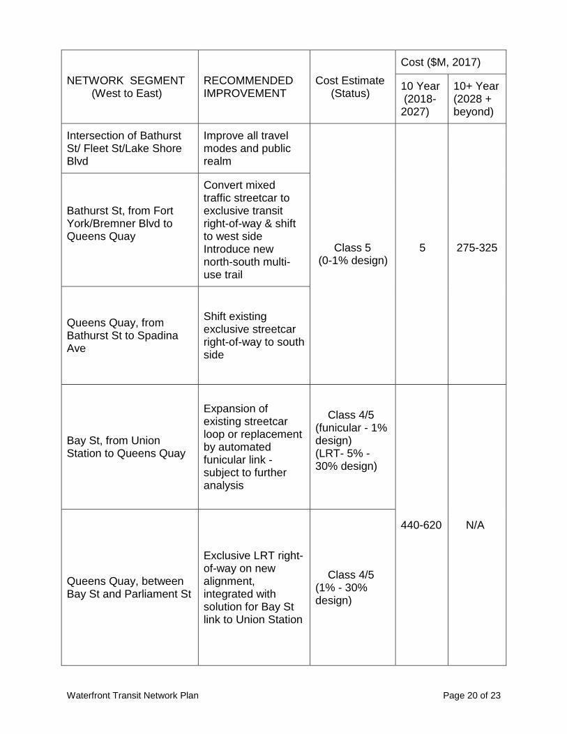
Intersection of Bathurst St/ Fleet St/Lake Shore Blvd
Improve all travel modes and public realm
Class 5 (0-1% design)
5
275-325
Bathurst St, from Fort York/Bremner Blvd to Queens Quay
Convert mixed traffic streetcar to exclusive transit right-of-way & shift to west side Introduce new north-south multi-use trail
Queens Quay, from Bathurst St to Spadina Ave
Shift existing exclusive streetcar right-of-way to south side
Bay St, from Union Station to Queens Quay
Expansion of existing streetcar loop or replacement by automated funicular link - subject to further analysis
Class 4/5 (funicular - 1% design) (LRT- 5% - 30% design)
440-620 N/A
Queens Quay, between Bay St and Parliament St
Exclusive LRT right-of-way on new alignment, integrated with solution for Bay St link to Union Station
Class 4/5 (1% - 30% design)

Waterfront Transit Network Plan Page 21 of 23
NETWORK SEGMENT (West to East)
RECOMMENDED IMPROVEMENT
Cost Estimate (Status)
Cost ($M, 2017)
10 Year (2018- 2027)
10+ Year (2028 + beyond)
Port Lands, including: - Parliament St to Broadview Ave via Queens Quay, Cherry St and Commissioners St - Broadview Ave Extension from Queen St to Commissioners St - Commissioners St between Broadview Ave Extension and Leslie Barns -Cherry St between the West Don Lands Loop and the Ship Channel
Exclusive LRT right-of-way
Class 5 (EA approved, 0-1% design)
350-400 190
Operational Infrastructure for Phasing (e.g. facilities, loop) 75 N/A
TOTAL COSTS (LOW)* ($M) 1165 815
TOTAL COSTS (HIGH)* ($M) 1395 915
*Costs do not include rolling stock. The initial preliminary (pre-design) cost estimate for completion of the entire Waterfront Transit Network is in the range of $1.980 billion to $2.310 billion in 2017 dollars. 6. Ferry Service Ferry Service along the waterfront was identified as a potential transit network solution during the course of the public consultation process for the study. The City's Central Waterfront Secondary Plan specifically recognizes water taxis and ferries as another way of moving people along the waterfront. Ferries can provide a supplemental option to the transit network. There are a number of factors that will have to be considered, including land side infrastructure, connections to the larger transportation network, travel time, costs, potential fare integration and structure, and climatic conditions, to name a few. This type of service will also require a business case and operation plan, and the City would welcome and consider any future proposals from the private sector.

Waterfront Transit Network Plan Page 22 of 23
7. Communications and Public Consultation Three Stakeholder Advisory Committee (SAC) meetings and two public forums were held as part of the Phase 2 consultation program to update on the study, present travel demand forecasts, screening and evaluation of alternatives, and preliminary directions to move forward to further study. The first SAC meeting was held on March 28, 2017, the second SAC meeting (west focus) was held on June 26th, 2017 and a third SAC meeting (central-east focus) was held on September 12, 2017. The public forums were held in the central and western waterfront, on September 18 and 26, 2017, respectively. Formal notices were published in local newspapers approximately two weeks before the public forums to encourage participation in the study. Webpages on the City of Toronto website (www.toronto.ca/waterfronttransit) and Waterfront Toronto website (http://www.waterfrontoronto.ca/explore_projects2/the_wider_waterfront/waterfront_transit_reset) were established at the study outset to provide details about the study area, background information and consultation events. Social media, E-blasts, email invitations to SAC members, Councillor e-newsletters and media advisories were also used to increase awareness of public consultation and encourage broad participation. Approximately 220 members of the public attended the public forums, and more than 70 detailed comment feedback forms were submitted to the study team at and following each forum. In general, there was agreement with the overall network plan direction and identified priority segments and next steps, including the importance of further analysis of options for a Union Station - Queens Quay link. A summary of consultation feedback is provided in Attachment 2. A presentation was made to members of the TTC's Advisory Committee on Accessible Transportation (ACAT) on October 31, 2017. ACAT members highlighted the importance of considering accessible issues throughout all project evaluations, and contributed other significant comments. 8. Conclusion In conclusion, the Phase 2 work described in this report provides a plan for a resilient Waterfront Transit Network that can adapt to 21st century mobility and placemaking trends. The overall plan and directions for the network were generally well received by the public and stakeholders. Although a solution for the underground link to Union Station was not reached during this phase, there is general understanding and agreement that further focused work is required to arrive at a complete sustainable mobility solution for this area, and then to move quickly to implement the solution. In view of these findings, staff recommend that City Council endorse that upcoming updates to the City's Official Plan be made in accordance with the waterfront transit network recommendations identified in this report, and authorize identified funding requests and further study and design of areas of the network according to priority.

Waterfront Transit Network Plan Page 23 of 23
There is an overall public expectation that completing the next steps and implementing solutions will be a key priority for the City, the Toronto Transit Commission and Waterfront Toronto.
CONTACT Gregg Lintern, MCIP, RPP David Stonehouse Acting Chief Planner & Executive Director Director, Waterfront Secretariat City Planning City Planning Tel. No. 416-392-8772 Tel. No. 416-392-8113 E-mail: [email protected] E-mail: [email protected] James Perttula Director, Transit and Transportation Planning City Planning Tel. No. 416-392-4744 E-mail: [email protected]
SIGNATURE John W. Livey, FCIP Deputy City Manager (Cluster B)
ATTACHMENTS Attachment 1: Planning and Technical Background Attachment 2: Consultation Summary