waterfront stormwater case studies - green futures...
TRANSCRIPT

LABRESEARCH GREEN FUTURES U n i ve r s i t y o f Wa s h i n g t o n C o l l e g e o f B u i l t E nv i ro n m e n t s
& DESIGN
242 Gould Hall Box 355734 | Seattle, WA 98195 | www.greenfutures.washington.edu
waterfront stormwater case studies

Table of ContentsProjects
Undercurrents– Haddad & Drugan Waitangi Park– Wraight & Associates Olympic Sculpture Park Nearshore Bench– Anchor QEA Victoria Park – Government’s Architect Office & HassellHoutan Park– Turenscape Magnusson Park– Berger Partnership & Sheldon and AssociatesHammarby Sjorsted Lugnet– Stockholm Water Living Doc– Michael Singer, Sanchez & Maddux, Steve Boruff ArchitectsLower Don- Michael Van Valkenburgh & Assoc.
Themes
ART
HABITATtechnical
educateRe-use
aquatic healthPark
CLeANseCover Photo Credit: PWL Partnership

UN
DERC
URR
ENTS
SEA
TTLE
, WA,
USUndercurrents is the public art component of King County’s Denny
Way/Lake Union CSO Project, a $140 million dollar project that reduces untreated combined sewer overflows into Elliott Bay and Lake Union through a series of pipes and tunnels. Laura Haddad, the design team artist, chose to focus the art at the marine outfall site in Myrtle Edwards Park, where the impact on water quality is most evident. The artwork consists of a landscaped plaza with integrated sculptural elements fabricated from stainless steel pipe that direct the viewer’s attention to the underground infrastructure.
Plaza runoff drains through a swale aligned over the outfall pipes, mimicking what happens underground during storms. The swale is etched with words and lines describing moving water. Wave-activated sound pipes are built into the new shoreline. Letters spelling “h’loo-loo-loo-loo-loo,” a sound from a native American myth about water, are embedded in the concrete paving in front of the soundpipes. Concrete for the paving and seatwalls is colored and stained and includes broadcast river rock. Gates and fences for the pump building beside the plaza are fabricated from pipe bent and welded to resemble reeds and eddies.
A second phase for this project currently in construction includes a new mechanical vault wrapped on three sides with a planted berm, symbolizing stormwater utility as green infrastructure. The fourth side is a stainless steel wall aligned with the existing swale and etched with a metaphoric pictogram depicting the processes of stormwater collection, transport, and treatment. Five mirrored stainless steel vent pipes extend out of the vault, conveying infrastructure that merges with its environment.
Source: http://www.haddad-drugan.com/projects/undercurrents.html
ArtDesigners: Haddad & Drugan
Photo Credit: Haddad and Drugan
Photo Credit: Haddad and Drugan
Photo Credit: 4Culture Photo Credit: Haddad and Drugan
Photo Credit: Haddad and Drugan
Undercurrents
WAI
TAN
GI P
ARK
WEL
LIN
GTO
N, N
EW Z
EALA
ND
source: Wraight & Associates
source: http://www.venueweb.co.nz/north/10_wellington/waitangi_park/waitangi.htm
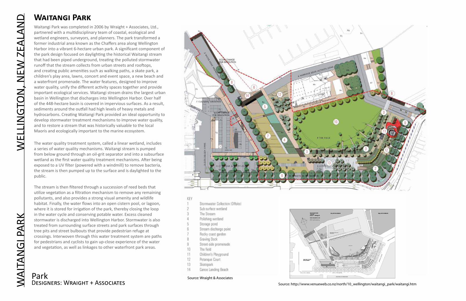
Waitangi Park was completed in 2006 by Wraight + Associates, Ltd., partnered with a multidisciplinary team of coastal, ecological and wetland engineers, surveyors, and planners. The park transformed a former industrial area known as the Chaffers area along Wellington Harbor into a vibrant 6-hectare urban park. A significant component of the park design focused on daylighting the historical Waitangi stream that had been piped underground, treating the polluted stormwater runoff that the stream collects from urban streets and rooftops, and creating public amenities such as walking paths, a skate park, a children’s play area, lawns, concert and event space, a new beach and a waterfront promenade. The water features, designed to improve water quality, unify the different activity spaces together and provide important ecological services. Waitangi stream drains the largest urban basin in Wellington that discharges into Wellington Harbor. Over half of the 448-hectare basin is covered in impervious surfaces. As a result, sediments around the outfall had high levels of heavy metals and hydrocarbons. Creating Waitangi Park provided an ideal opportunity to develop stormwater treatment mechanisms to improve water quality, and to restore a stream that was historically valuable to the local Maoris and ecologically important to the marine ecosystem.
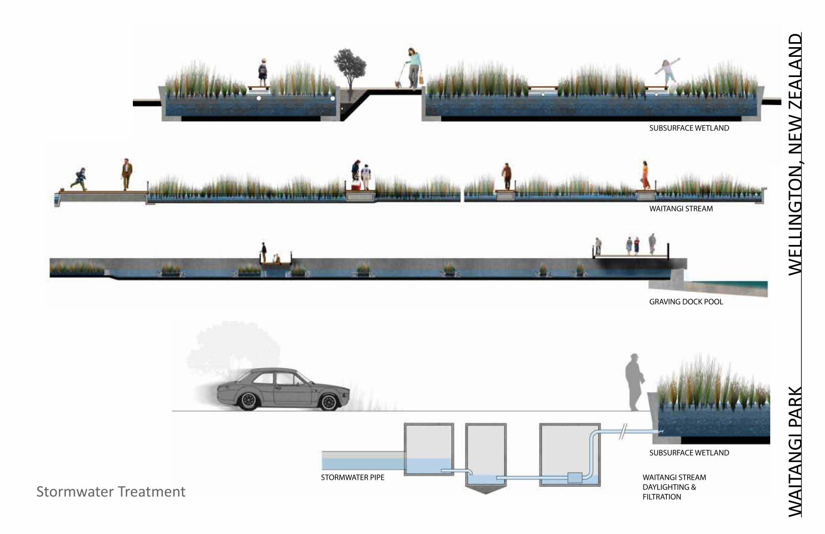
The water quality treatment system, called a linear wetland, includes a series of water quality mechanisms. Waitangi stream is pumped from below ground through an oil-grit separator and into a subsurface wetland as the first water quality treatment mechanisms. After being exposed to a UV filter (powered with a windmill) to remove bacteria, the stream is then pumped up to the surface and is daylighted to the public.
The stream is then filtered through a succession of reed beds that utilize vegetation as a filtration mechanism to remove any remaining pollutants, and also provides a strong visual amenity and wildlife habitat. Finally, the water flows into an open cistern pool, or lagoon, where it is stored for irrigation of the park, thereby closing the loop in the water cycle and conserving potable water. Excess cleaned stormwater is discharged into Wellington Harbor. Stormwater is also treated from surrounding surface streets and park surfaces through tree pits and street bulbouts that provide pedestrian refuge at crossings. Interwoven through this water treatment system are paths for pedestrians and cyclists to gain up-close experience of the water and vegetation, as well as linkages to other waterfront park areas.
Designers: Wraight + AssociatesPark
Waitangi Park
suBsuRFACe WeTLAND
WAITANGI sTReAM
GRAVING DOCK POOL
suBsuRFACe WeTLAND
sTORMWATeR PIPe WAITANGI sTReAM DAYLIGHTING & FILTRATION
WAI
TAN
GI P
ARK
WEL
LIN
GTO
N, N
EW Z
EALA
ND
Stormwater Treatment

Photo Credit: www.wellingtoncivictrust.org
Photo Credit: Nancy Rottle
Photo Credit: City of Wellington
Waitangi Treatment Train Original text updated from Wraight + Associates
Waitangi stream diversionThe underground piped stream/stormwater currently runningis diverted into Waitangi Park. Water is harvested upstream of Cable Street via a weir mechanism. Wind or solar powered pumps bring the water just below the surface of the activity zone, where heavy particulates are settled out and grease scum are skimmed.
Waitangi streamBetween 10-15 L/s of water is diverted into a 6.0 meter wide linear wetland system. Particulate pollutants are removed from the water as it passes through the densely planted native sedges and reeds. Concurrently, water permeates into the gravelly subgrade where bio-organisms remove suspended pollutants. Plants help maintain the porosity of the filtering medium.
Graving Dock WetlandSeries of thickly planted sloped terraces that provides a further polishing process as the water moves down slope towards the harbour.
Storage PondFiltered Water is conveyed into a large open air pond. A combination of shallow planted ledges and deeper open bodies of water are visually captivating. The pond stores enough water for re-use in site-wide irrigation and water features.
Discharge into harbourWater discharges at both the Waka Landing and Clyde Quay terminations of the linear wetlands. Both provide opportunities for interpretive art installations and sophisticated urban design solutions.
Bio-retention TreepitsTree planting along the streetside promenade, in addition to framing this generously wide pedestrian way, incorporates bio-retention/filtra-tion features. Stormwater runoff from the parkside of the road and the promenade itself is directed into treepits through either a series of kerb slots or dish drains. Water collects within the sunken planted tree pits then slowly filters through the soil medium where contaminants are removed by micro-organisms inhabiting the root zone.
WAI
TAN
GI P
ARK
WEL
LIN
GTO
N, N
EW Z
EALA
ND
Designers: Wraight & AssociatesStormwater Treatment
Water quality results indicate that the treatment system is working. Water quality samples indicate that fecal coliform was reduced 90-99%, and heavy metals were reduced to concentrations below water quality guideline levels. Ongoing monitoring will determine how well the system will perform as it evolves and ages.
Photo Credit: Wraight + Associates

OLy
MPI
C SC
ULP
TURE
PAR
K
SE
ATTL
E, W
A, U
S
Designers: Anchor QEA & Charles Anderson Landscape Architects with Weiss Manfredi Architects, Magnusson Klemencic Associates
The Seattle Art Museum’s Olympic Sculpture Park portrays how restoration of urban waterfronts for habitat can provide meaningful refuge for both wildlife and people in urban settings. Formerly a fuel storage and transfer station, the park underwent a dramatic transformation in order to reclaim the waterfront and to share art with the public in an outdoor setting. Visitors experience artwork by international renowned artists and gain impressive views of Puget Sound. The artwork is dispersed amongst native Pacific Northwest landscapes that descend from mountain to sea vegetation communities as visitors move towards the waterfront to the tidal garden and beach.
Several features highlight the application of water treatment that fuse multiple values of waterfronts and create rich social settings. The native vegetation not only reintroduces native species, but also intercepts rainfall, preventing stormwater runoff. Compacted soils were improved and designed to mimic pre-development soil properties by absorbing and percolating water into the ground and slowly releasing groundwater into Elliot Bay (Seattle Art Museum 2010). The pocket beach is designed to restore habitat for aquatic species and to provide public access to the waterfront. Overhanging vegetation now shades and cools the water, a shallow sub-tidal habitat supports juvenile salmon rearing and migration and a tidal garden of kelp and algae is visible at low tide. A shoreline trail provides easy access for park visitors, and connects the sculpture park via the Elliot Bay trail to Myrtle Edwards and to downtown.
Monitoring of the beach and tidal habitat indicates biological functions are similar to older, more established beaches as indicated by colonization by kelp, invertebrates and salmonids (Toft et al 2009). The rich cultural and environmental experiences provided by the Olympic Sculpture Park demonstrates how waterfronts can fuse together diverse interests and needs to achieve multiple benefits.
Olympic Sculpture Park Nearshore Bench
Photo Credit: Nancy Rottle
Image Credit: Anchor QeA, LLC Image Credit: MKA

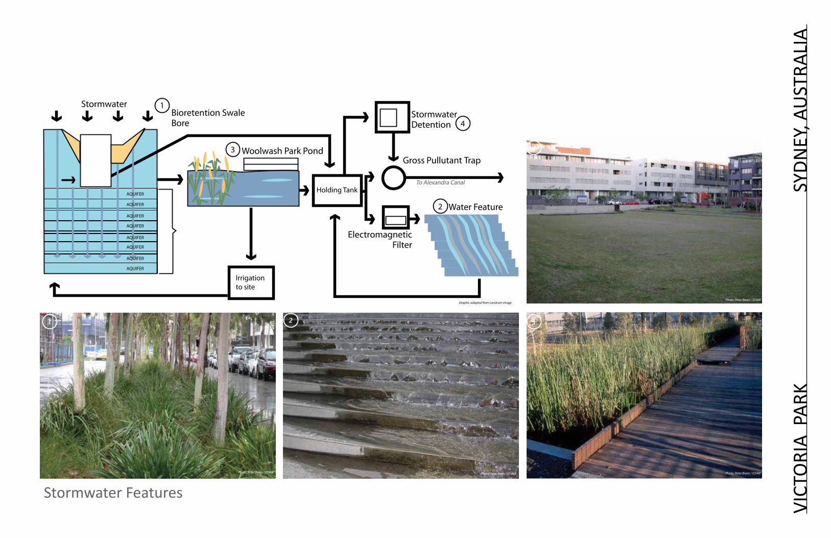
Historically the site was a lagoon wetland ecosystem that drained to the tidal estuary of Cooks River and Botany Bay. The lagoon was drained in 1910 and developed into a race track, car plant and eventually into a Naval Stores Depot. Redevelopment plans required substantial water management strategies.
Government Architect’s office and Hassell collaborated to develop a stormwater based design. Dual roadways drain inwards from the footpath edge to a saw tooth, permeable curb, then to a bio-remediation swale located in the median. Water flows into the swales and is filtered and infiltrated by sand beds, grasses and groundcovers which remove most of the particulate matter and contaminants suspended in urban stormwater. The plantings, selected for drought and flood tolerance, assist in the uptake of nitrogenous wastes and create a root mat which keeps the sand filters stable and free draining.
The swale system is designed to treat first flush stormwater. Flows in excess of a one-in-five-year event are captured by a system of weirs and inlets set beneath pedestrian bridges which are built across the swales. Peak flows are channelled through subsurface pipes to the dished excavation of the detention basin located in the central park, which falls to a sedimentation pond and constructed wetland set within a grove of paperbarks. Due to the location of the detention basin in the centre of the scheme, rather than the low point on the western boundary, the system needs a pump-out capacity, which is also utilized to draw irrigation water from the aquifer during long periods of low rainfall.
To express the artifice of this solution, a water sculpture by Jennifer Turpin and Michaelie Crawford is installed as a surreal series of steps set into the slopes of the central basin – a controlled cascade of recycled stormwater. The water for this art installation seems to well from an unknown source – but it is drawn from the final stage of the water treatment process, a storage tank and reed bed integrated with a pocket park at the western entrance to the neighborhood.
Text and Photo Sources unless noted otherwise: JAMES WEIRICKhttp://www.architecturemedia.com/aa/aaissue.php?issueid=200401&article=12&typeon=2
VICT
ORI
A P
ARK
S
yDN
Ey, A
UST
RALI
A
Designers: Government Architect’s Office and HassellPark
95Case Studies
02Stormwater Detention
Gross Pullutant Trap
Electromagnetic Filter
Woolwash Park Pond
Bioretention Swale Bore
Stormwater
Irrigation to site
Holding Tank
Water Feature
1
3
4
2
AQUIFER
AQUIFER
AQUIFER
AQUIFER
AQUIFER
AQUIFER
AQUIFER
AQUIFER
1 2 3
4
To Alexandra Canal
Photo: Peter Breen / EDAW Photo: Peter Breen / EDAW Photo: Peter Breen / EDAW
Photo: Peter Breen / EDAWGraphic adapted from Landcom image
victoria Park
95Case Studies
02Stormwater Detention
Gross Pullutant Trap
Electromagnetic Filter
Woolwash Park Pond
Bioretention Swale Bore
Stormwater
Irrigation to site
Holding Tank
Water Feature
1
3
4
2
AQUIFER
AQUIFER
AQUIFER
AQUIFER
AQUIFER
AQUIFER
AQUIFER
AQUIFER
1 2 3
4
To Alexandra Canal
Photo: Peter Breen / EDAW Photo: Peter Breen / EDAW Photo: Peter Breen / EDAW
Photo: Peter Breen / EDAWGraphic adapted from Landcom image
VICT
ORI
A P
ARK
SyDN
Ey, A
UST
RALI
A
Stormwater Features
HOU
TAN
PAR
K
SHA
NGA
I, CH
INA
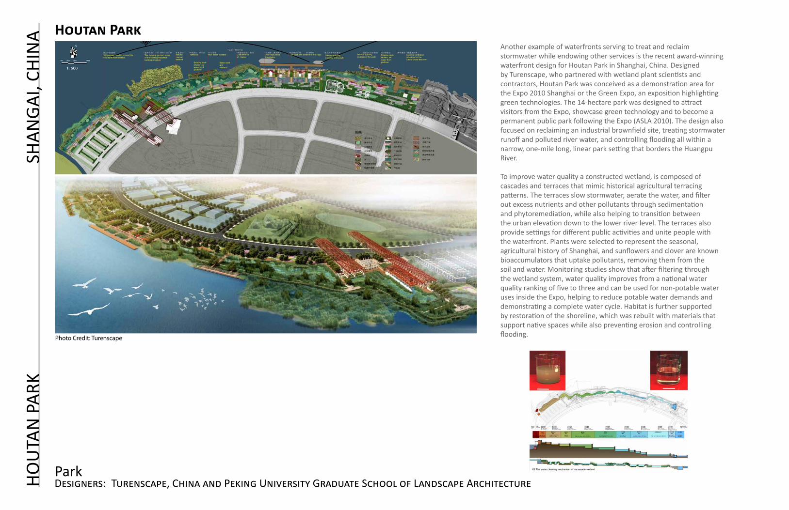
Another example of waterfronts serving to treat and reclaim stormwater while endowing other services is the recent award-winning waterfront design for Houtan Park in Shanghai, China. Designed by Turenscape, who partnered with wetland plant scientists and contractors, Houtan Park was conceived as a demonstration area for the Expo 2010 Shanghai or the Green Expo, an exposition highlighting green technologies. The 14-hectare park was designed to attract visitors from the Expo, showcase green technology and to become a permanent public park following the Expo (ASLA 2010). The design also focused on reclaiming an industrial brownfield site, treating stormwater runoff and polluted river water, and controlling flooding all within a narrow, one-mile long, linear park setting that borders the Huangpu River.
To improve water quality a constructed wetland, is composed of cascades and terraces that mimic historical agricultural terracing patterns. The terraces slow stormwater, aerate the water, and filter out excess nutrients and other pollutants through sedimentation and phytoremediation, while also helping to transition between the urban elevation down to the lower river level. The terraces also provide settings for different public activities and unite people with the waterfront. Plants were selected to represent the seasonal, agricultural history of Shanghai, and sunflowers and clover are known bioaccumulators that uptake pollutants, removing them from the soil and water. Monitoring studies show that after filtering through the wetland system, water quality improves from a national water quality ranking of five to three and can be used for non-potable water uses inside the Expo, helping to reduce potable water demands and demonstrating a complete water cycle. Habitat is further supported by restoration of the shoreline, which was rebuilt with materials that support native spaces while also preventing erosion and controlling flooding.
Designers: Turenscape, China and Peking University Graduate School of Landscape ArchitecturePark
Houtan Park
Photo Credit: Turenscape

HO
uTA
N P
ARK
s
HA
NG
AI,
CHIN
A
Cultural history is prominent throughout the park. Industrial structures are references to Shanghai’s industrial past and are reclaimed as gardens, art forms and platforms. Paths circulate throughout the site inviting people through the space, to stop and enjoy views, recreate, experience the stunning natural and industrial forms, admire the various plant fragrances and colors, and to learn about green remediation techniques and Shanghai’s industrial and agricultural heritage.
The unifying force of the water quality wetland is a vital component of the park. The constructed wetland provides the backbone from which additional values are inherently linked. The Park also showcases how water treatment can create beautiful spaces the public finds delightful. Houtan Park achieves multiple goals and demonstrates how waterfronts can be unifying, regenerative spaces, especially in highly polluted urban areas. Such seamless harmony earned Houtan Park the American Society of Landscape Architect’s (ASLA) Professional Award of Excellence in 2010.
For additional information http://www.asla.org/2010awards/006.html
Photo Credit: Turenscape
Photo Credit: TurenscapePhoto Credit: Turenscape

HOU
TAN
PAR
K
SHA
NGA
I, CH
INA
Designers: Turenscape, China and Peking University Graduate School of Landscape ArchitectureArt & Culture
Photo Credit: TurenscapePhoto Credit: Turenscape
Photo Credit: Turenscape
Phot
o Cr
edit:
Tur
ensc
ape

MAG
NU
SON
PAR
K
SEA
TTLE
, WA,
US
Designers: Berger Partnership, Sheldon and Associates
The Warren G. Magnuson Park – Wetland, Habitat and Athletic Field Development project is a 43-acre park that includes athletic fields and wetlands in place of 10-acres of pavement from a former air base. The wetlands are located in the southeast section of the Park south of the five ballfields that include a rugby, ultimate frisbee, soccer, little league/softball, and baseball fields.
The ballfields are also part of the stormwater treatment process. They absorb and direct stormwater to a bioswale where pollutants are filtered out and then through the series of wetland chambers that are made of concrete to represent man-made forms. This hard form breaks down as the water moves into the lagoon that takes on a more natural form and indicates clean water for habitat.
Habitat for amphibians and the marsh wren were made high priority goals of the project, and dragonflies species are said to be quite numerous.
Habitat & Active Use Park
Magnuson Park
Photo Credit: Leslie Batten
Photo Credit: Magnusson Klemcic Associates

HAM
MAR
By S
JöST
AD
S
TOCK
HO
LM, S
WED
EN
Designers: City of Stockholm
The 250-hectare Hammarby Waterfront City is a former industrial area located just outside Stockholm that has transformed into a master planned mixed-use development that provides 11,000 housing units with commercial services on the main floor and office space and public transportation. Strict environmental rules and the main canal, Hammarby Sjö or Hammarby Lake, form the heart around which the new development is centered. To prevent contaminated water from degrading Hammarby Sjö, stormwater is treated locally through a system called Local Stormwater Treatment. This involves several treatment mechanisms: green roofs to intercept and evapo-transpire rainwater, infiltration into the ground, drainage into canals that supply Hammarby Sjö or a stormwater canal that runs through the park Sjöstadsparterren, enclosed settling tanks for street and roadway stormwater where runoff is held until particulates settle out and other structural BMPs that include: swales, magazines, gully pot filters, infiltration, and ponds (Karlsson 2006).
The Lugnet or urban wetlands is a passive stormwater treatment system that collects stormwater from 3-acres of surrounding surface streets to filter out pollutants before conveyance into the Lake (Figure 20). The system first filters water through an oil separator, then moves into an open sedimentation forebay. The water subsequently moves passively through a series of five beds of varying depth and lined with geotextile that convey water horizontally through vegetation that include: Phragmites australis, (common reed), Nymphaea Marliacea Rosea (water lily- Rosea), Iris pseudacorus (yellow-flag iris), Lythrum salicaria (purple loosestrife), Menyanthes trifoliate (buckbean), Carex rostrata (beaked sedge), Persicaria amphibia (water smartweed), and Eleocharis palustris (common spikerush). These species were selected for their ability to remove phosphorus (Fagerberg 2011). (It is important to note that many of these species are highly invasive in the United States and should be avoided at all costs.) There are five water meadows that passively treat the water before it is discharged into the lake. Along the edges of the urban wetlands are walkways that allow people to view the system and walk alongside them. A covered pergola borders the southern edge of the wetlands allowing people to access the site under extreme weather conditions (Figure 22). Stockholm Water officials indicated that all of the streets that will drain into this wetland have not been built yet so it is not clear how successful the treatment system is (Fagerberg 2011). Specific details were difficult to get due to the language barrier.
Urban Treatment
Hammarby Sjöstad - Lugnet
Photo Credit: stockholm Water
Photo Credit: stockholm Water
Photo Credit: Jack Ahern

HAM
MAR
By S
JöST
AD
STO
CKH
OLM
, SW
EDEN
Image Credits: stockholm Water
Stormwater Treatment
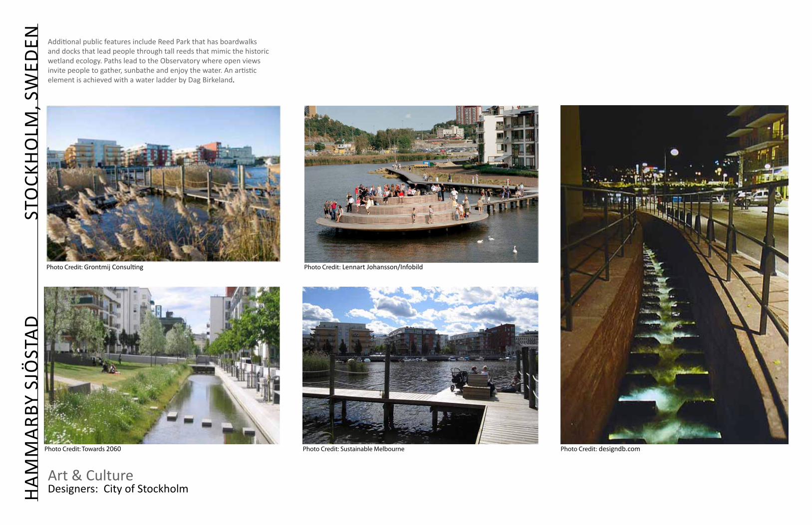
Additional public features include Reed Park that has boardwalks and docks that lead people through tall reeds that mimic the historic wetland ecology. Paths lead to the Observatory where open views invite people to gather, sunbathe and enjoy the water. An artistic element is achieved with a water ladder by Dag Birkeland.
Photo Credit: Grontmij Consulting Photo Credit: Lennart Johansson/Infobild
Photo Credit: designdb.comPhoto Credit: Towards 2060 Photo Credit: sustainable Melbourne
Art & Culture
HAM
MAR
By S
JöST
AD
S
TOCK
HO
LM, S
WED
EN
Designers: City of Stockholm

LIVI
NG
DO
CK
WES
T PA
LM B
EACH
, FLO
RID
A, U
S
Designers: Michael Singer, Sanchez & Maddux, Steve Boruff Architects
Redevelopment of West Palm Beach waterfront included the creation of a ”living” dock that doubles as a water-filtration system. Native species such as, spartina grass, mangroves, and oysters are nurtured through special habitat indentations in the dock. The habitat features float below the dock and are visible to the public. Oyster shells discarded from restaurants fill the oyster beds and encourage settling by oyster spat to help grow the oyster reef. Oysters can filter 40 gallons of water every day. Reverence to the historic natural heritage of Florida’s ecology is an important contribution to water quality improvements as well as a beautiful public waterfront.
Text and photo Sources: Michael Singer and GeenSource: http://greensource.construction.com/features/Solutions/2010/april/1004_Hope_Floats.asp
Habitat & Urban
Living Dock

Urban Estuary: MVVA proposes a new mouth for the river that flows logically from the upstream source, bypassing the abrupt right turn created by the channel. A large new meandering riverfront park becomes the centerpiece of a new mixed-use neighborhood where the social program is just as important as the ecological one.
Stormwater: Design emphasizes goals to improve stormwater and flood control by creating wetlands and storage area. Large stormwater tanks treat stormwater using filtration and UV light before releasing it. Stormwater in newly developed areas of the Lower Don Lands is separated into three different flow paths/streams. Road runoff containing salt and other pollutants won’t be of sufficient quality to feed the needs of the wetlands, so a discreet stream of water collected from building roofs will be used to feed the naturalized habitat. Excess water will be used to irrigate Silva Cells, underground structures designed to prevent soil compaction and retain stormwater beneath roads and sidewalks, and protect and encourage the growth of tree roots.
Text and Image Source: MVVA and Daily Commercial News: http://www.dcnonl.com/article/id40330?search_term=environmental%20assessment
LOW
ER D
ON
RIV
ER
T
ORO
NTO
, CAN
ADA
Designers: Michael Van Valkenburgh and Associates Proposed Desgin