waterfront redevelopment plan - cityofasburypark.com · as far back as 1978, the city’s master...
TRANSCRIPT

Asbury ParkWaterfront Redevelopment Plan
March 15, 2002
Adopted:Amended:Amended:Amended:Amended:Amended:Amended:
November 7, 1984January 7, 1987
April 3, 1991June 5, 2002 (Ord. # 2607)
March 2, 2005 (Ord. # 2729)August 3, 2005 (Ord. #2740)
December 7, 2005 (Ord. #2754)

Asbury Park Waterfront Redevelopment Plan
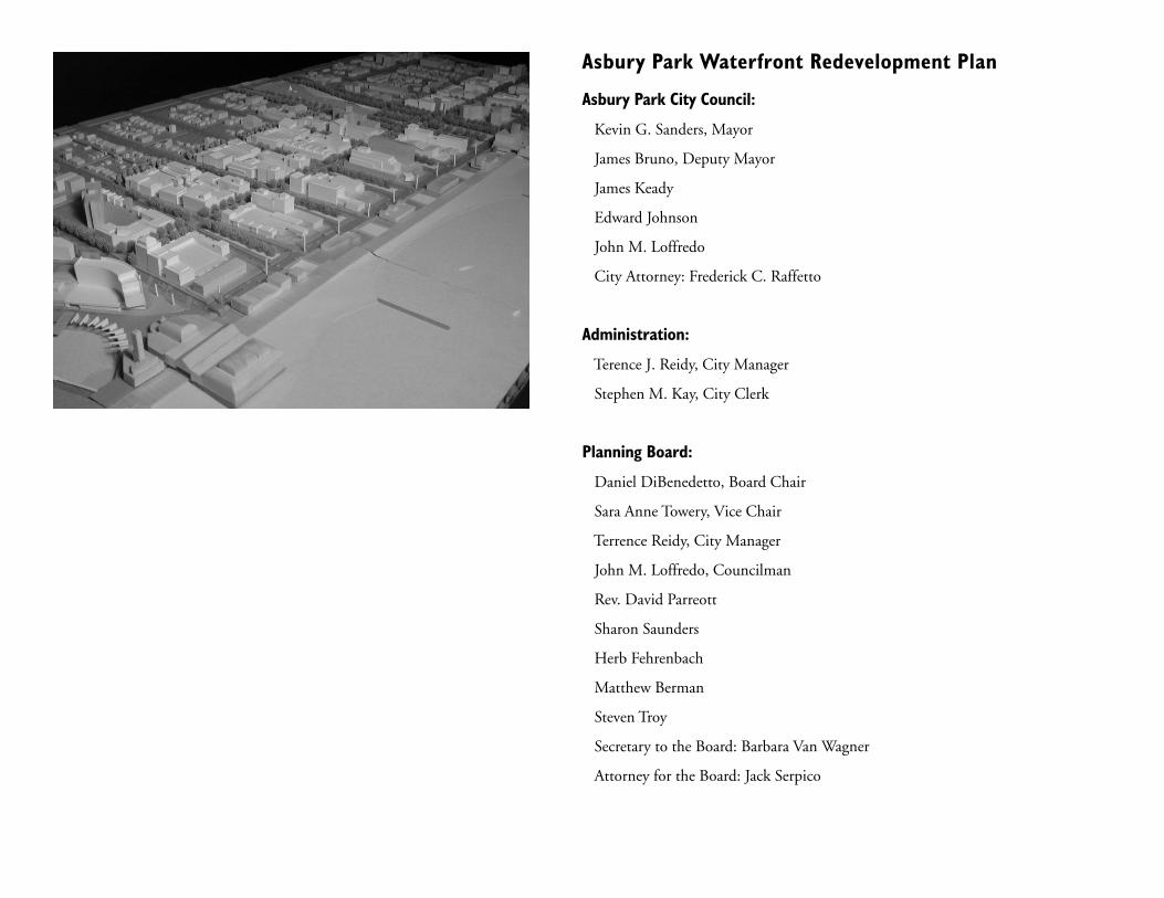
Asbury Park City Council:
Kevin G. Sanders, Mayor
James Bruno, Deputy Mayor
James Keady
Edward Johnson
John M. Loffredo
City Attorney: Frederick C. Raffetto
Administration:
Terence J. Reidy, City Manager
Stephen M. Kay, City Clerk
Planning Board:
Daniel DiBenedetto, Board Chair
Sara Anne Towery, Vice Chair
Terrence Reidy, City Manager
John M. Loffredo, Councilman
Rev. David Parreott
Sharon Saunders
Herb Fehrenbach
Matthew Berman
Steven Troy
Secretary to the Board: Barbara Van Wagner
Attorney for the Board: Jack Serpico

Page
Background
Introduction 1
1.1 Evolution of the Waterfront Redevelopment Plan 3
1.2 Bradley Plan of 1877 5
Design Principles
2.1 Redevelopment Area 7
2.2 Redevelopment Objectives 9
2.3 Planning Objectives within Prime Renewal-Area 11
Plan Elements
3.1 Plan Summary 21
3.2 Open Space, Recreation and Community Facilities 23
3.3 Historic and/or Significant Buildings 27
3.4 Vehicular Circulation 33
3.5 Parking in the Prime Renewal Area 47
3.6 Landscape Architecture 52
3.7 Architectural Design Guidelines 59
3.8 Land Use 68
3.9 Public Utilities 77
3.10 Environmental Contamination 78
Page
Implementation
4.1 Property Acquisition 79
4.2 Workable Relocation Assistants Plan (WRAP) 81
4.3 Affordable Housing 82
4.4 Special Improvement District (SID) 83
4.5 Amending the Waterfront Redevelopment Plan 83
4.6 Termination of Redevelopment Plan 83
Relationship to Other Plans
5.1 New Jersey State Development and Redevelopment Plan 85
(State Plan)
5.2 Asbury Park Master Plan 88
5.3 Monmouth Growth Management Plan 90
5.4 Adjacent Municipalities 90
5.5 NJDEP Coastal Zone Management 90
Appendix A - Definitions
Definitions 92
Table of Contents

BACKGROUND
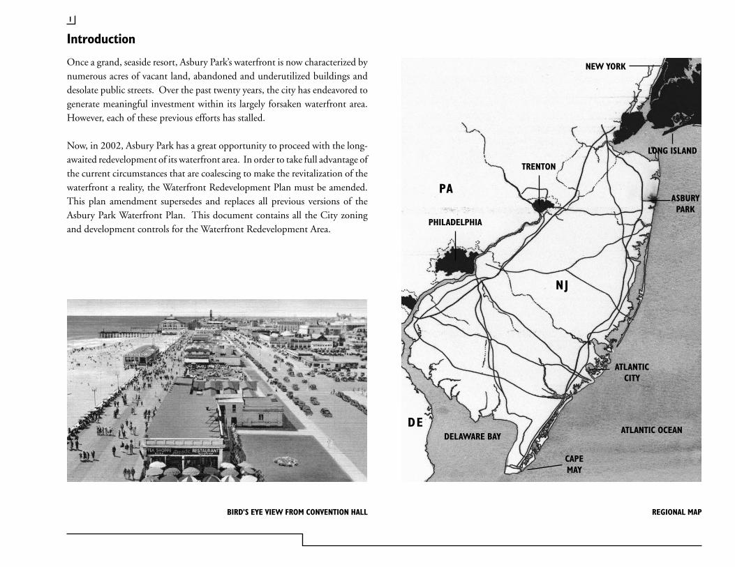
Once a grand, seaside resort, Asbury Park’s waterfront is now characterized by numerous acres of vacant land, abandoned and underutilized buildings and desolate public streets. Over the past twenty years, the city has endeavored to generate meaningful investment within its largely forsaken waterfront area. However, each of these previous efforts has stalled.
Now, in 2002, Asbury Park has a great opportunity to proceed with the long-awaited redevelopment of its waterfront area. In order to take full advantage of the current circumstances that are coalescing to make the revitalization of the waterfront a reality, the Waterfront Redevelopment Plan must be amended. This plan amendment supersedes and replaces all previous versions of the Asbury Park Waterfront Plan. This document contains all the City zoning and development controls for the Waterfront Redevelopment Area.
Introduction
1
ATLANTIC OCEAN
PA
PHILADELPHIA
TRENTON
NEW YORK
LONG ISLAND
ASBURYPARK
NJ
DE
ATLANTICCITY
CAPEMAY
DELAWARE BAY
BIRD’S EYE VIEW FROM CONVENTION HALL REGIONAL MAP
ASBURY PARK WATERFRONT REDEVELOPMENT PLAN
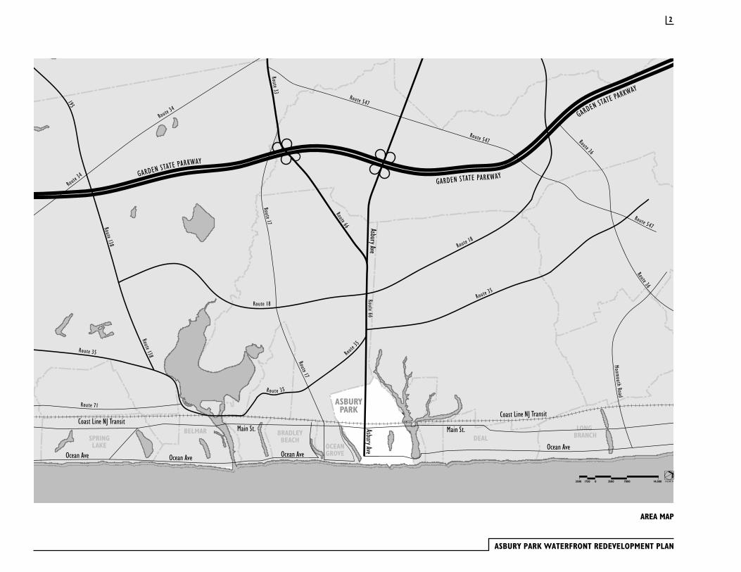
AREA MAP
Rout e 35
2
NORTH3500017503500 7000 14,000
As far back as 1978, the City’s Master Plan documented the need to undertake a comprehensive program of redevelopment within the 230 acres of land between Grand Avenue and the Boardwalk. The simple solution suggested to address the situation included two components: 1) concentrated code enforcement to improve conditions of residential areas which could be preserved and 2) assemblage of underutilized property for major reconstruction.
The problems identified in 1978 Master Plan were not substantially altered by 1984: the existing housing stock continued to fall far short of meeting modern standards, businesses were severely depressed (compared to former times), and more land was becoming vacant with each passing year. The steady increase of tax-exempt properties, coupled with the steady demolition of buildings in the area, was resulting in a gradual lowering of the tax base of the city. This placed an ever-increasing tax burden on the remaining tax paying properties.
Based on those conditions, in 1984 the City found the area between Grand Avenue and the beach to be blighted or in need of redevelopment pursuant to the New Jersey State Redevelopment law. The original Waterfront Area
Redevelopment plan was adopted on November 7, 1984. It has been amended twice, on January 7, 1987 and again on April 3, 1991.
For various reasons, the 1984 Redevelopment Plan, as amended, has not been implemented. In 1986, the City selected Carabetta/Vaccaro Developers, a limited partnership, to be the prime developer of the area within the redevelopment zone where new construction was planned. Carabetta/ Vaccaro began the redevelopment effort with the construction of a 16 story, 224-unit condominium project called Ocean Mile. In 1989, Carabetta bought out Vaccaro and renamed the company Ocean Mile Development Group. Before construction of the condominium project was complete, Ocean Mile filed for bankruptcy. At that point all development activity in redevelopment area stopped. Now, approximately ten years after the bankruptcy of the Ocean Mile project, the City has selected a new prime developer, Asbury Partners, LLC, to take over the role that Ocean Mile was to have played.
With a new prime developer in place, the Waterfront Redevelopment Plan needs to be amended to reflect the public’s vision of the scale and character of new construction, and to take into consideration current and anticipated real estate market conditions.
1.1 Evolution of the Waterfront Redevelopment Plan
3
ASBURY PARK WATERFRONT REDEVELOPMENT PLAN
KINGSLEYSTREET
BERGH STREET
STREETWEBB
OCEANAVENUE
FIRS
TAV
ENUE
SECO
NDAV
ENUE
THIR
D
FOUR
TH
AVEN
UE
AVEN
UE
FIFT
HAV
ENUE
HECK STREET
SUNS
ET
AVEN
UE
AVENUEPARK
STREETEMORYSTREETEMORY
ASBU
RYAV
ENUE
STREETBOND
STREETMAIN
SEW
ALL
AVEN
UE
MON
ROE
AVEN
UE
SUM
MER
FIEL
DAV
ENUE
BANG
SAV
ENUE
MAT
TISO
NAV
ENUE
COOKMAN
AVENUE
ST JAMESPLACE
AVENUE
LAKE
AVEN
UE
LAKE
COOK
MAN
MAT
TISO
NAV
ENUE
BANG
SAV
ENUE
SUM
MER
FIEL
DAV
ENUE
MON
ROE
AVEN
UE
SEW
ALL
AVEN
UE
ASBU
RYAV
ENUE
FIRS
TAV
ENUE
SECO
NDAV
ENUE
THIR
D
FOUR
TH
AVEN
UE
AVEN
UE
FIFT
HAV
ENUE
SIXT
HAV
ENUE
SEVE
NTH
AVEN
UE
EIGH
THAV
ENUE
DRIVEMEMORIAL
SUNS
ETAV
ENUE
SIXT
HAV
ENUE
DEAL
LAKE
DRIV
E
AVEN
UE
LAKE
STREETLANGFORD
STREETCOMSTOCK
PROSPECT
AVENUE
PROS
PECT
AVEN
UE
PROSPECT
AVENUE
PINE
STREET
PINE STREET
NEW STREET
CHURCH
STREET
BRIDGE STREET
DRURYLANE
SUNSET
DRIVE
LOCUST
DRIVE
JEFFREY
STREET
CENTRAL
AVENUE
DUNLEWY
STREET
DRUMMOND
AVENUE
DUNLEWY
STREET
CENTRAL
AVENUE
RIDGE
AVENUE
BOST
ON
WAY
SYLVAN AVENUE
ATKINS
AVENUEAVENUEA
BORDEN
AVENUE
DEWITT
AVENUE
ELIZABETH
AVENUE
MAT
TISO
N
AVEN
UE
BANG
S
AVEN
UE
SUM
MER
FIEL
D
AVEN
UE
WAS
HING
TON
AVEN
UE
MON
ROE
AVEN
UE
SEW
ALL
AVEN
UE
ATLA
NTIC
AVEN
UE
AVENUE
UNION
SPRUCE
STREET
MONMOUTH
AVENUE
JEFF
ERSO
N
AVEN
UE
NEPTUNETOWNSHIP OCEAN
TOWNSHIP
BOROUGH OFINTERLAKEN
NEPTUNETOWNSHIP
OCEANGROVE
VILLAGE OFLOCH ARBOUR
DEALLAKE
DEALLAKE
SUNSETLAKE
WESLEY LAKE
REDEVELOPMENTAREA
ASBURYPARK
GRAND AVENUEGRAND AVENUE
4
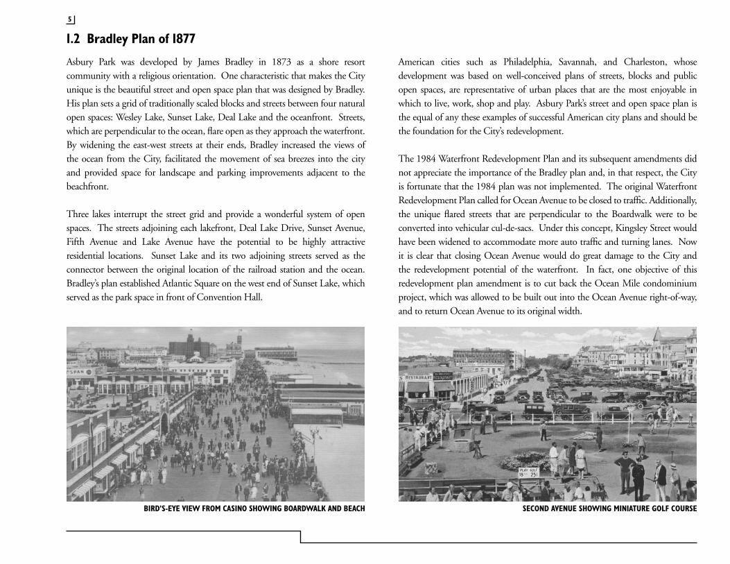
Asbury Park was developed by James Bradley in 1873 as a shore resort community with a religious orientation. One characteristic that makes the City unique is the beautiful street and open space plan that was designed by Bradley. His plan sets a grid of traditionally scaled blocks and streets between four natural open spaces: Wesley Lake, Sunset Lake, Deal Lake and the oceanfront. Streets, which are perpendicular to the ocean, flare open as they approach the waterfront. By widening the east-west streets at their ends, Bradley increased the views of the ocean from the City, facilitated the movement of sea breezes into the city and provided space for landscape and parking improvements adjacent to the beachfront.
Three lakes interrupt the street grid and provide a wonderful system of open spaces. The streets adjoining each lakefront, Deal Lake Drive, Sunset Avenue, Fifth Avenue and Lake Avenue have the potential to be highly attractive residential locations. Sunset Lake and its two adjoining streets served as the connector between the original location of the railroad station and the ocean. Bradley’s plan established Atlantic Square on the west end of Sunset Lake, which served as the park space in front of Convention Hall.
American cities such as Philadelphia, Savannah, and Charleston, whose development was based on well-conceived plans of streets, blocks and public open spaces, are representative of urban places that are the most enjoyable in which to live, work, shop and play. Asbury Park’s street and open space plan is the equal of any these examples of successful American city plans and should be the foundation for the City’s redevelopment.
The 1984 Waterfront Redevelopment Plan and its subsequent amendments did not appreciate the importance of the Bradley plan and, in that respect, the City is fortunate that the 1984 plan was not implemented. The original Waterfront Redevelopment Plan called for Ocean Avenue to be closed to traffic. Additionally, the unique flared streets that are perpendicular to the Boardwalk were to be converted into vehicular cul-de-sacs. Under this concept, Kingsley Street would have been widened to accommodate more auto traffic and turning lanes. Now it is clear that closing Ocean Avenue would do great damage to the City and the redevelopment potential of the waterfront. In fact, one objective of this redevelopment plan amendment is to cut back the Ocean Mile condominium project, which was allowed to be built out into the Ocean Avenue right-of-way, and to return Ocean Avenue to its original width.
1.2 Bradley Plan of 1877
BIRD’S-EYE VIEW FROM CASINO SHOWING BOARDWALK AND BEACH SECOND AVENUE SHOWING MINIATURE GOLF COURSE
5
ASBURY PARK WATERFRONT REDEVELOPMENT PLAN
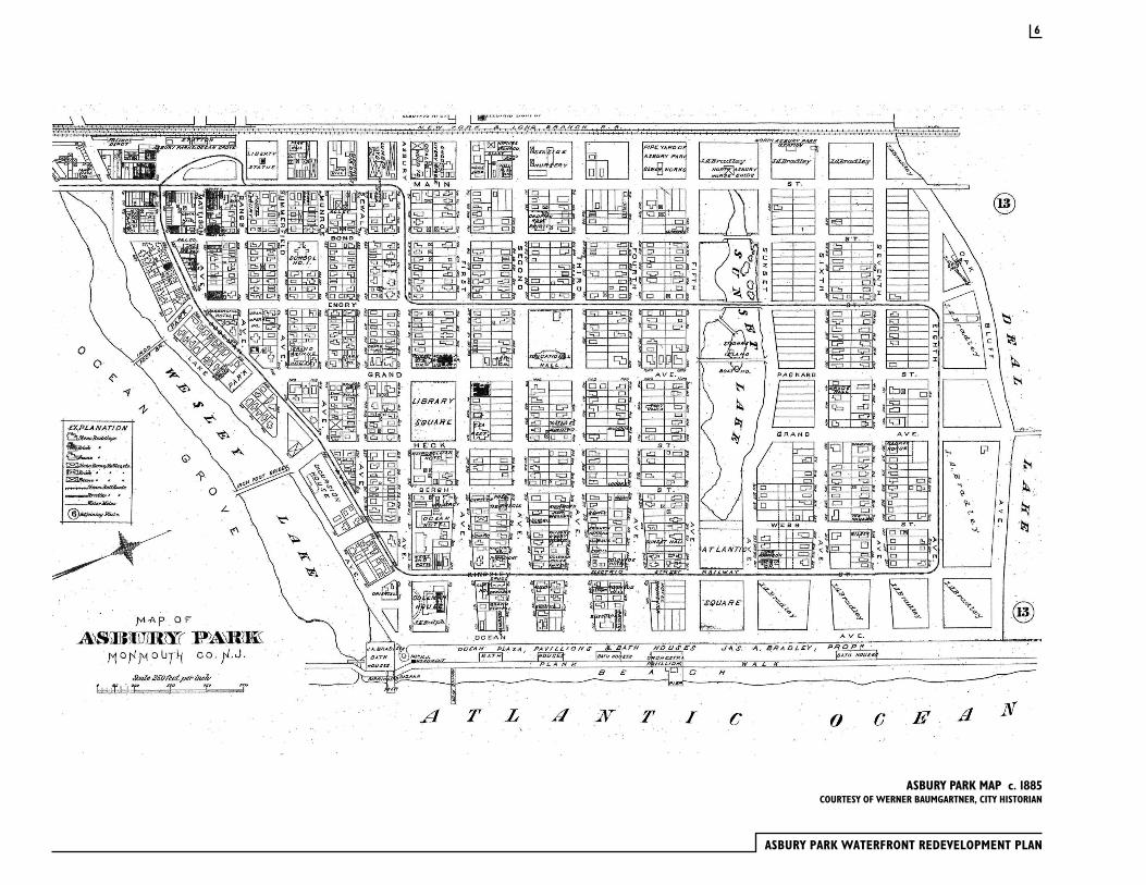
ASBURY PARK MAP c. 1885COURTESY OF WERNER BAUMGARTNER, CITY HISTORIAN
6

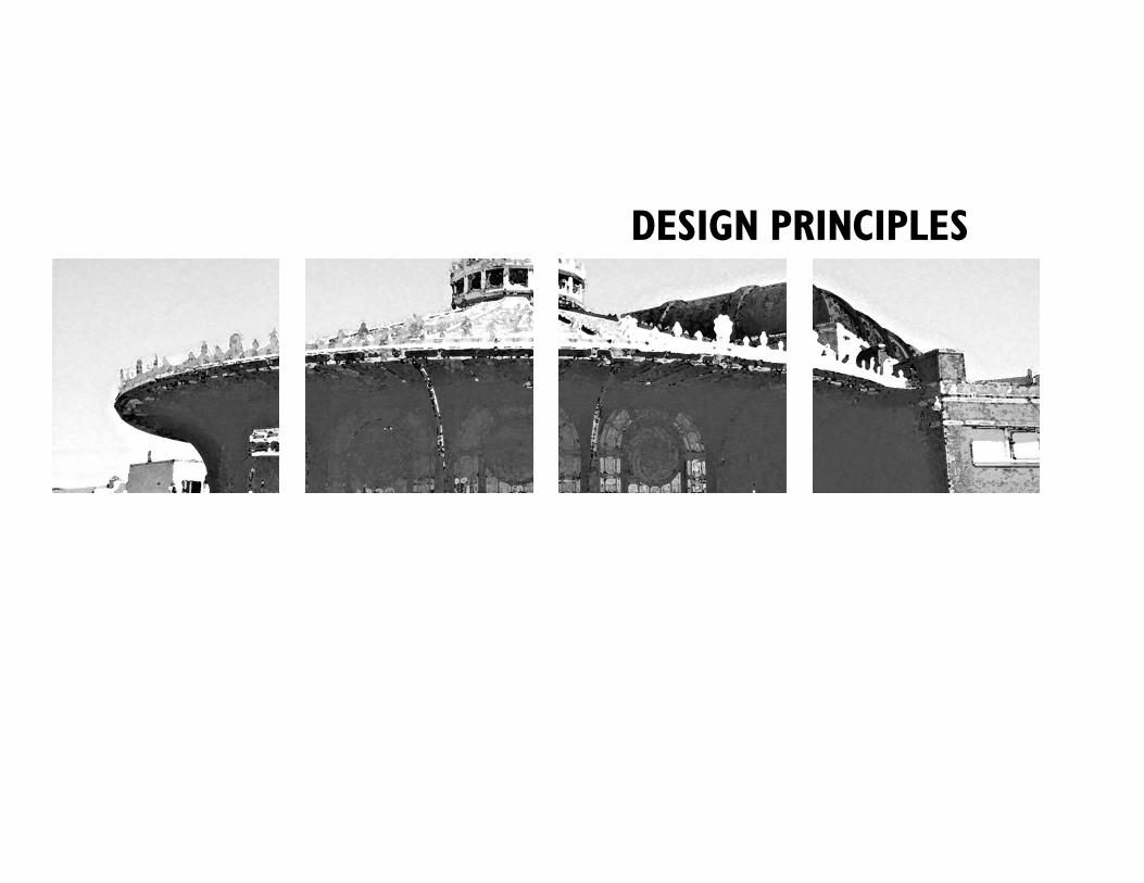
DESIGN PRINCIPLES
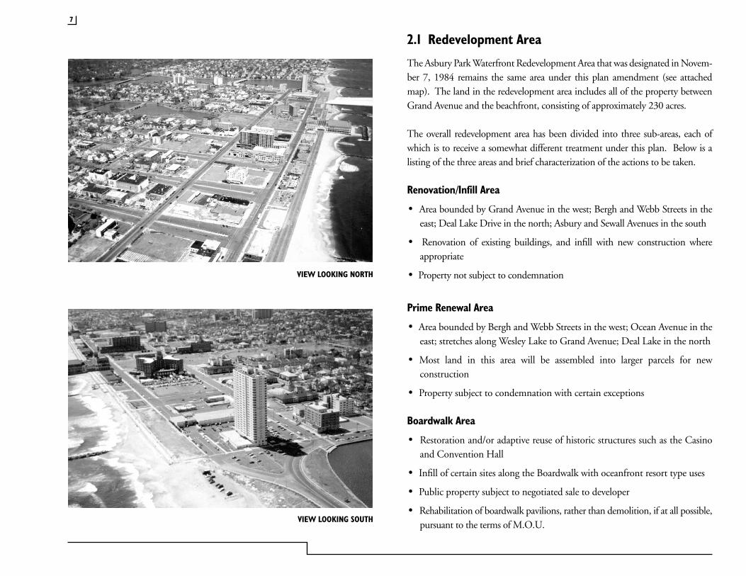
2.1 Redevelopment Area
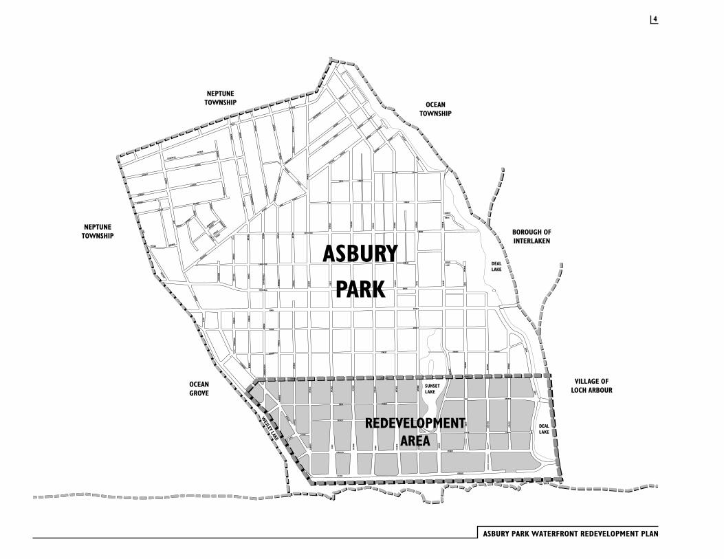
The Asbury Park Waterfront Redevelopment Area that was designated in Novem-ber 7, 1984 remains the same area under this plan amendment (see attached map). The land in the redevelopment area includes all of the property between Grand Avenue and the beachfront, consisting of approximately 230 acres.
The overall redevelopment area has been divided into three sub-areas, each of which is to receive a somewhat different treatment under this plan. Below is a listing of the three areas and brief characterization of the actions to be taken.
Renovation/Infill Area
· Area bounded by Grand Avenue in the west; Bergh and Webb Streets in the east; Deal Lake Drive in the north; Asbury and Sewall Avenues in the south
· Renovation of existing buildings, and infill with new construction where appropriate
· Property not subject to condemnation
Prime Renewal Area
· Area bounded by Bergh and Webb Streets in the west; Ocean Avenue in the east; stretches along Wesley Lake to Grand Avenue; Deal Lake in the north
· Most land in this area will be assembled into larger parcels for new construction
· Property subject to condemnation with certain exceptions
Boardwalk Area
· Restoration and/or adaptive reuse of historic structures such as the Casino and Convention Hall
· Infill of certain sites along the Boardwalk with oceanfront resort type uses
· Public property subject to negotiated sale to developer
· Rehabilitation of boardwalk pavilions, rather than demolition, if at all possible, pursuant to the terms of M.O.U.
7
VIEW LOOKING SOUTH
VIEW LOOKING NORTH
ASBURY PARK WATERFRONT REDEVELOPMENT PLAN
��
� ���
���� ��
����
�
��
��� �
����� �
� ���
� ��
��
� �� �
� ��� ��
� ��
���
��
��� �
����� �
� ���
�
��
����
������
���
���
��������������
����
������
����
���� ��
� ���
�
�����������������
��
����
������
���
�� �
��
����
�� �� ��
���
�� �
��
� ���
� �����
��
��� �
��
����
���� ��
���
��
����������������
��������������������
��
����
����� �
� �� �
��
����
�����
�����
����
�
��������������
��
����
������
� ��
���
��
����
�� ����
���
��
�
��
����
���� � �
� �� �
���
��
��
�����������������
����
�����
�����
�� �����������������
��
����
���� ��
����
�
����������������
�����������������
�����������������
����������������
�����������������
��������������������
�����������������
����
������
������
����
���
�
����������������
����������������
�����������������������������������������������������������������
����������������
����������������
��
����
������
��
���
��
����
���� ��
���
� ���
�
�����������������
����������
��������� ���������
���������
��������������
����������������
����������������
�����������������
��������������������
���
�����
���
�
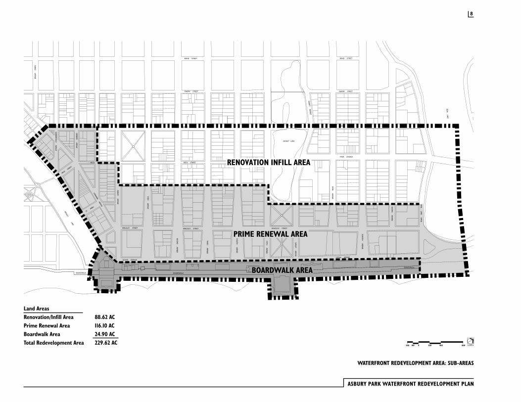
RENOVATION INFILL AREA
PRIME RENEWAL AREA
BOARDWALK AREA
WATERFRONT REDEVELOPMENT AREA: SUB-AREAS
NORTH2000100200 400 800
8
Land AreasRenovation/Infill Area 88.62 ACPrime Renewal Area 116.10 ACBoardwalk Area 24.90 ACTotal Redevelopment Area 229.62 AC
As part of the process to amend the Asbury Park Waterfront Redevelopment Plan, the City held several public meetings, including a nine day charrette, at which citizens were asked to express their concerns and goals for the redevelopment area. Planning and design consultants working for the City, as well as those engaged by the prime developer, presented their analysis of conditions in the area and concepts which might guide the redevelopment effort. Out of these meetings the City identified four overall Community Goals:
· Preserve the character and history of Asbury Park
· Make Asbury Park a great community to live in all year round
· Generate new tax revenue for the City
· Spur economic growth through employment opportunities
As the process continued, the City set forth ten planning principles that have been used as the basis of revisions to the waterfront redevelopment area plan:
Waterfront Area Planning Principles
· Encourage new residential development
· Preserve the important buildings
· Preserve the Bradley Plan
· Preserve the memories of past entertainment
· Re-create Asbury Park as an entertainment center
· Prevent residential/entertainment conflicts
· Make Asbury Park a place for families
· Respect Asbury Park’s historic character
· Create pedestrian-friendly streets
· Prevent parking & traffic problems
As the citizen participation process progressed, the design principles for the project became more specific:
Design Principles
· Bring the city back down to the ocean.
· Create a positive first impression on the following arrival streets: Asbury Avenue: Neighborhood arrival; historic, Victorian, small scale. Cookman Avenue: Downtown arrival; urban, active, slightly taller building. Sunset Avenue: North Shore arrival; park-like setting, more open, buildings integrated with park.
· Create three Oceanside districts: “Wesley Lake Village”, “Ocean Avenue”, and North Shore”, each with its own character and environment.
· Create a nighttime entertainment district around the Casino.
· Maintain on street parking wherever possible. Locate public parking near the entertainment district. Each residential block must contain spaces/unit-parking program.
· Add new streetscape elements to help integrate on-street parking near the beach upland beyond Kingsley.
· Preserve the historic buildings within the area and re-use them to support new development including the upland neighborhoods.
· Locate and configure taller buildings perpendicular to the ocean to maximize views from upland neighborhoods.
· Develop new residential buildings that are compatible with and extend Asbury Park’s special Oceanside character in a contemporary way.
The redevelopment plan described in this amendment is based on the design principles listed above.
2.2 Redevelopment Objectives
9
ASBURY PARK WATERFRONT REDEVELOPMENT PLAN
10
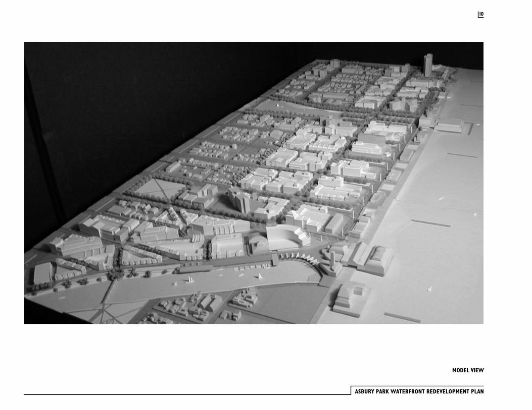
MODEL VIEW
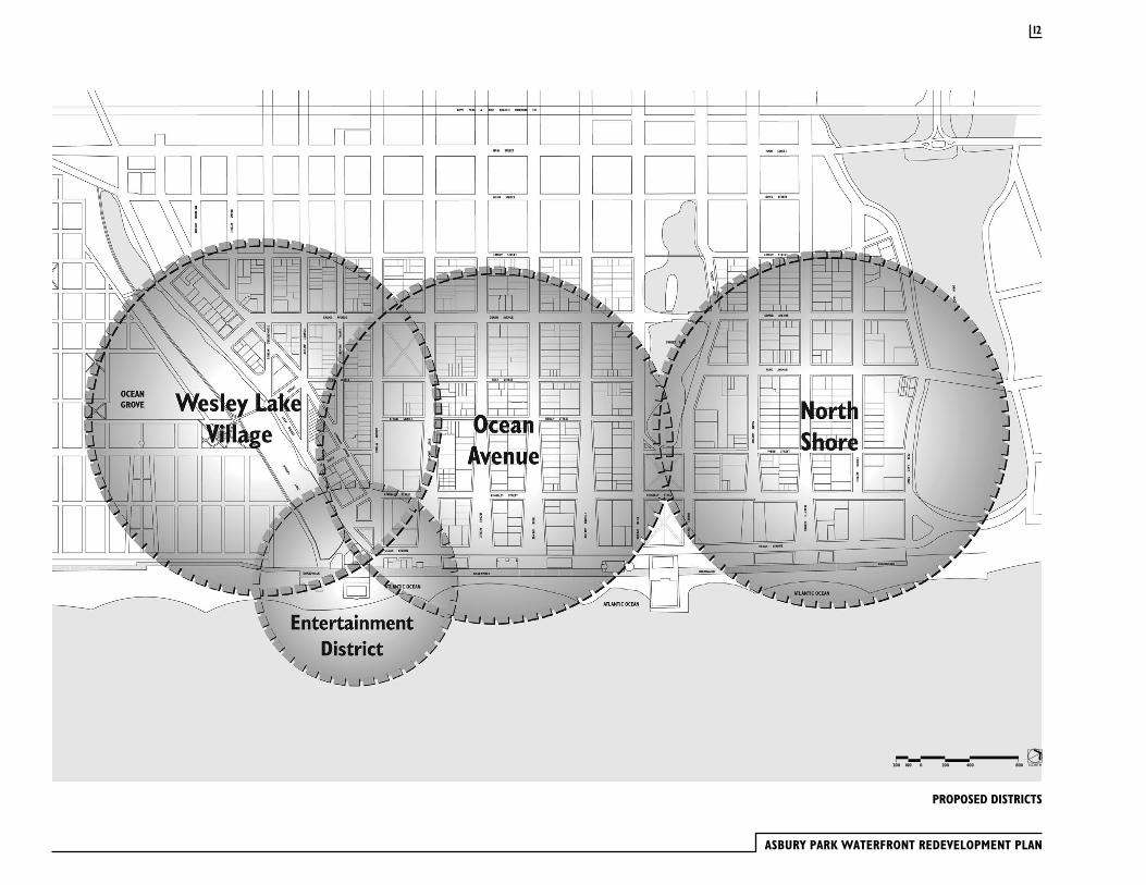
In spite of the fact that the prime renewal area looks depressed today, the location presents a major development opportunity. It is difficult to think of any other location on the East Coast, with excellent highway and rail access similar to that of Asbury Park, where one can assemble approximately 58 acres of oceanfront property for new mixed-use development. In order to organize the perception of future development along the waterfront, four neighborhoods have been identified. These are the Wesley Lake District, the Avenue, the North Shore and the Entertainment District. Each neighborhood will have a distinct character and a range of development opportunities.
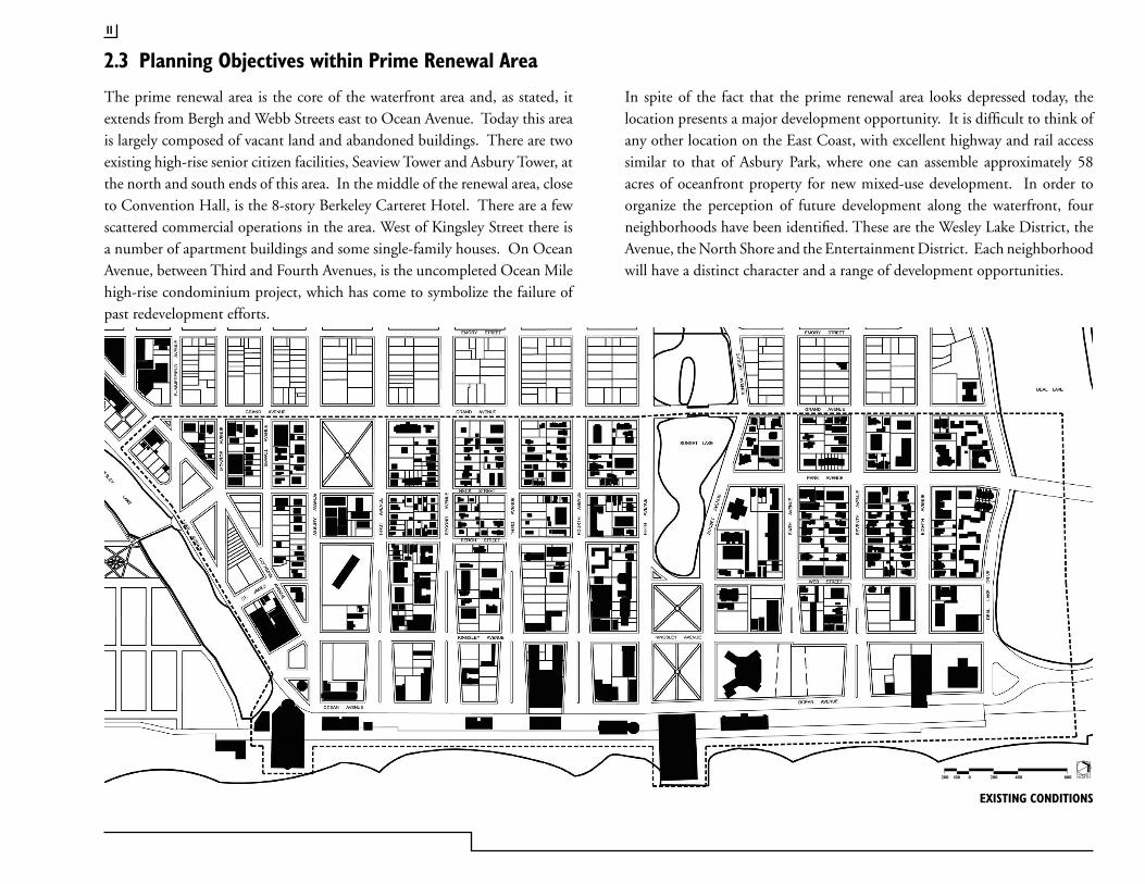
The prime renewal area is the core of the waterfront area and, as stated, it extends from Bergh and Webb Streets east to Ocean Avenue. Today this area is largely composed of vacant land and abandoned buildings. There are two existing high-rise senior citizen facilities, Seaview Tower and Asbury Tower, at the north and south ends of this area. In the middle of the renewal area, close to Convention Hall, is the 8-story Berkeley Carteret Hotel. There are a few scattered commercial operations in the area. West of Kingsley Street there is a number of apartment buildings and some single-family houses. On Ocean Avenue, between Third and Fourth Avenues, is the uncompleted Ocean Mile high-rise condominium project, which has come to symbolize the failure of past redevelopment efforts.
2.3 Planning Objectives within Prime Renewal Area
EXISTING CONDITIONS
NORTH2000100200 400 800
11
ASBURY PARK WATERFRONT REDEVELOPMENT PLAN
PROPOSED DISTRICTS
NORTH2000100200 400 800
12
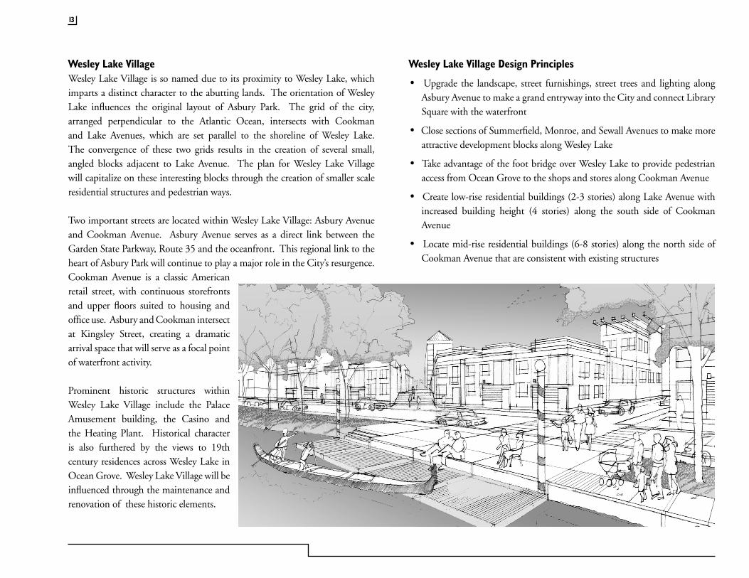
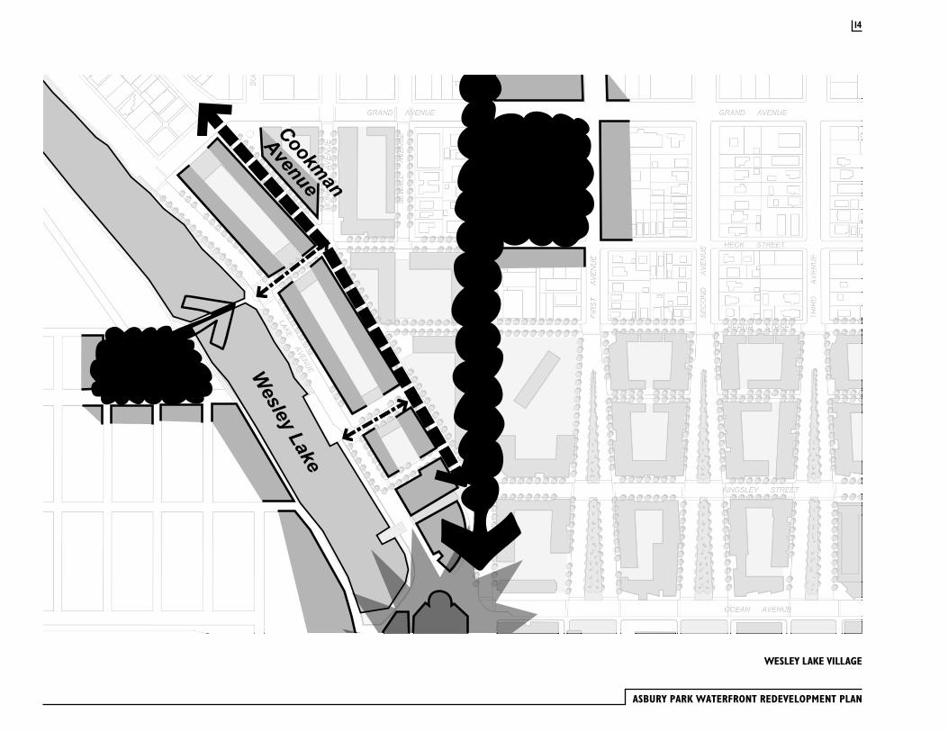
Wesley Lake VillageWesley Lake Village is so named due to its proximity to Wesley Lake, which imparts a distinct character to the abutting lands. The orientation of Wesley Lake influences the original layout of Asbury Park. The grid of the city, arranged perpendicular to the Atlantic Ocean, intersects with Cookman and Lake Avenues, which are set parallel to the shoreline of Wesley Lake. The convergence of these two grids results in the creation of several small, angled blocks adjacent to Lake Avenue. The plan for Wesley Lake Village will capitalize on these interesting blocks through the creation of smaller scale residential structures and pedestrian ways.
Two important streets are located within Wesley Lake Village: Asbury Avenue and Cookman Avenue. Asbury Avenue serves as a direct link between the Garden State Parkway, Route 35 and the oceanfront. This regional link to the heart of Asbury Park will continue to play a major role in the City’s resurgence. Cookman Avenue is a classic American retail street, with continuous storefronts and upper floors suited to housing and office use. Asbury and Cookman intersect at Kingsley Street, creating a dramatic arrival space that will serve as a focal point of waterfront activity.
Prominent historic structures within Wesley Lake Village include the Palace Amusement building, the Casino and the Heating Plant. Historical character is also furthered by the views to 19th century residences across Wesley Lake in Ocean Grove. Wesley Lake Village will be influenced through the maintenance and renovation of these historic elements.
Wesley Lake Village Design Principles
· Upgrade the landscape, street furnishings, street trees and lighting along Asbury Avenue to make a grand entryway into the City and connect Library Square with the waterfront
· Close sections of Summerfield, Monroe, and Sewall Avenues to make more attractive development blocks along Wesley Lake
· Take advantage of the foot bridge over Wesley Lake to provide pedestrian access from Ocean Grove to the shops and stores along Cookman Avenue
· Create low-rise residential buildings (2-3 stories) along Lake Avenue with increased building height (4 stories) along the south side of Cookman Avenue
· Locate mid-rise residential buildings (6-8 stories) along the north side of Cookman Avenue that are consistent with existing structures
13
ASBURY PARK WATERFRONT REDEVELOPMENT PLAN
WESLEY LAKE VILLAGE
14
Cookman
Avenue
Wesley
Lake
Asbury
Avenue

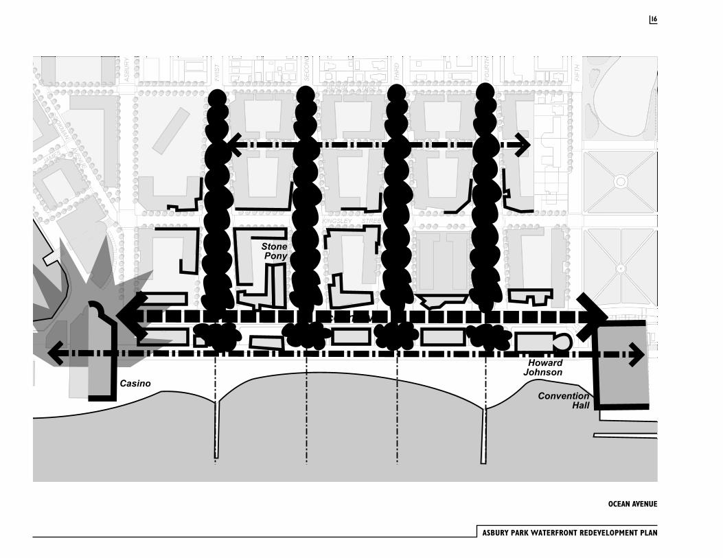
Ocean AvenueThe five blocks along Ocean Avenue, between the Casino and Convention Hall, are the core of Asbury Park’s waterfront. The objective is to make this section of Ocean Avenue a lively, active street with continuous ground floor retail and restaurant uses. The pavilions between Ocean Avenue and the Boardwalk will contain retail, entertainment and restaurant operations of a more seasonal nature. These buildings will have commercial storefronts on both the Boardwalk and Ocean Avenue. Upper floors of these structures can be used for commercial or office activities. The open spaces between the Boardwalk pavilions will be developed as either passive or active recreation areas. Active uses include miniature golf, boccie, and children’s play areas.
Improving the visual character of ends of the flared streets at Ocean Avenue is an important goal of this plan. New curbs, sidewalks, street furnishings, ornamental lighting, street trees and ornamental plantings will be installed. The streets will be designed to accommodate surface parking in a highly attractive manner. Parking bays will be set at an angle, reminiscent of the historic parking layout within Asbury Park’s streets. Plant material will be selected and located in full cognizance of the oceanfront environment.
Ocean Avenue Design Principles
· Develop new commercial buildings facing Ocean Avenue that are no more than 3 stories in height, with varied rooflines and “festive” character
· Create new buildings in the block between Ocean Avenue and Kingsley Street ranging from 4-8 stories in height, with parking on the interior of the block
· Line Kingsley Street with mid-rise residential buildings (6-8 stories), thereby placing the majority of new residences away from the ocean’s edge
· Limit the height of mid-block buildings along both sides of Kingsley Street to 3 or 4 stories to allow views of the ocean through the blocks
· Decrease building heights from mid-rise to townhouse scale in the blocks between Kingsley and Bergh Streets to match the scale of the adjacent existing residential area
· Extend Webb Street through the creation of a mews or new street that also serves to reduce the block length between Kingsley and Bergh Streets
15
ASBURY PARK WATERFRONT REDEVELOPMENT PLAN
OCEAN AVENUE
16
Ocean Ave
ConventionHall
HowardJohnson
Casino
StonePony
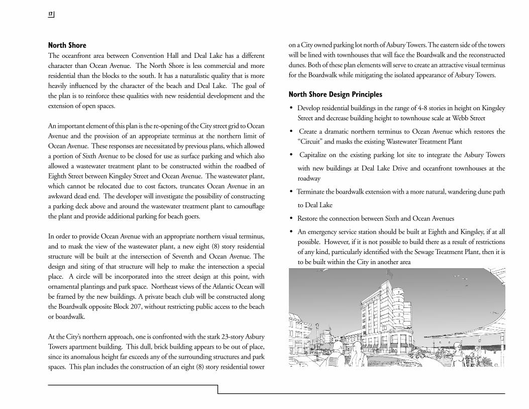
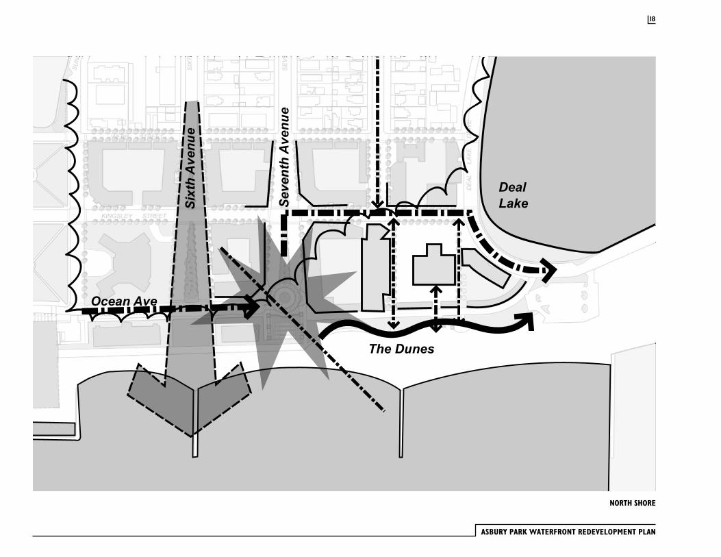
North ShoreThe oceanfront area between Convention Hall and Deal Lake has a different character than Ocean Avenue. The North Shore is less commercial and more residential than the blocks to the south. It has a naturalistic quality that is more heavily influenced by the character of the beach and Deal Lake. The goal of the plan is to reinforce these qualities with new residential development and the extension of open spaces.
An important element of this plan is the re-opening of the City street grid to Ocean Avenue and the provision of an appropriate terminus at the northern limit of Ocean Avenue. These responses are necessitated by previous plans, which allowed a portion of Sixth Avenue to be closed for use as surface parking and which also allowed a wastewater treatment plant to be constructed within the roadbed of Eighth Street between Kingsley Street and Ocean Avenue. The wastewater plant, which cannot be relocated due to cost factors, truncates Ocean Avenue in an awkward dead end. The developer will investigate the possibility of constructing a parking deck above and around the wastewater treatment plant to camouflage the plant and provide additional parking for beach goers.
In order to provide Ocean Avenue with an appropriate northern visual terminus, and to mask the view of the wastewater plant, a new eight (8) story residential structure will be built at the intersection of Seventh and Ocean Avenue. The design and siting of that structure will help to make the intersection a special place. A circle will be incorporated into the street design at this point, with ornamental plantings and park space. Northeast views of the Atlantic Ocean will be framed by the new buildings. A private beach club will be constructed along the Boardwalk opposite Block 207, without restricting public access to the beach or boardwalk.
At the City’s northern approach, one is confronted with the stark 23-story Asbury Towers apartment building. This dull, brick building appears to be out of place, since its anomalous height far exceeds any of the surrounding structures and park spaces. This plan includes the construction of an eight (8) story residential tower
on a City owned parking lot north of Asbury Towers. The eastern side of the towers will be lined with townhouses that will face the Boardwalk and the reconstructed dunes. Both of these plan elements will serve to create an attractive visual terminus for the Boardwalk while mitigating the isolated appearance of Asbury Towers.
North Shore Design Principles
· Develop residential buildings in the range of 4-8 stories in height on Kingsley Street and decrease building height to townhouse scale at Webb Street
· Create a dramatic northern terminus to Ocean Avenue which restores the “Circuit” and masks the existing Wastewater Treatment Plant
· Capitalize on the existing parking lot site to integrate the Asbury Towers
with new buildings at Deal Lake Drive and oceanfront townhouses at the roadway
· Terminate the boardwalk extension with a more natural, wandering dune path
to Deal Lake
· Restore the connection between Sixth and Ocean Avenues
· An emergency service station should be built at Eighth and Kingsley, if at all possible. However, if it is not possible to build there as a result of restrictions of any kind, particularly identified with the Sewage Treatment Plant, then it is to be built within the City in another area
17
ASBURY PARK WATERFRONT REDEVELOPMENT PLAN
NORTH SHORE
18
Ocean Ave
Casino
The Dunes
DealLakeSi
xthAvenu
e
SeventhAvenu
e
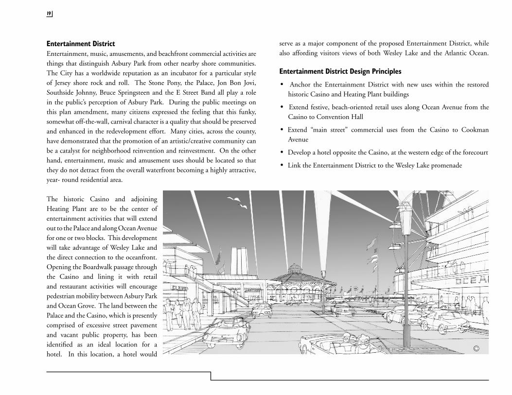
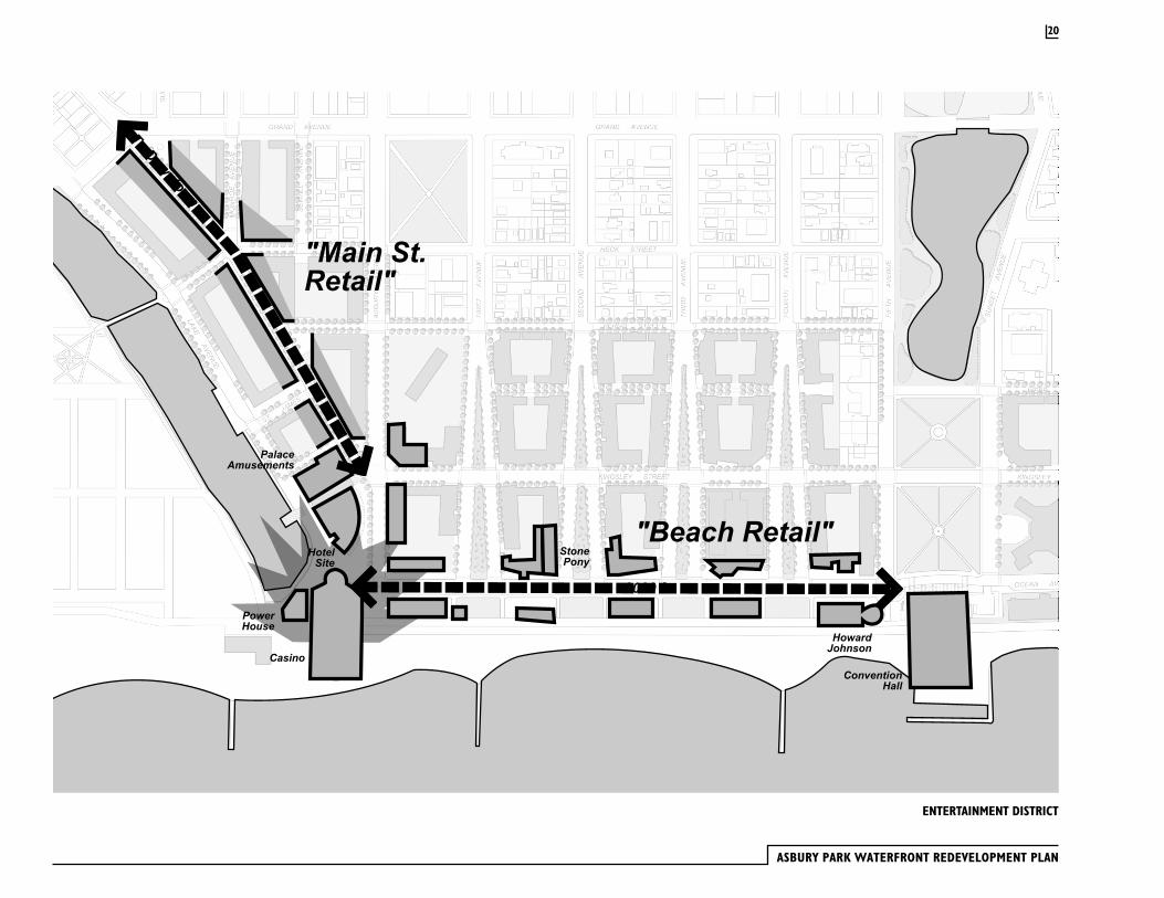
Entertainment DistrictEntertainment, music, amusements, and beachfront commercial activities are things that distinguish Asbury Park from other nearby shore communities. The City has a worldwide reputation as an incubator for a particular style of Jersey shore rock and roll. The Stone Pony, the Palace, Jon Bon Jovi, Southside Johnny, Bruce Springsteen and the E Street Band all play a role in the public’s perception of Asbury Park. During the public meetings on this plan amendment, many citizens expressed the feeling that this funky, somewhat off-the-wall, carnival character is a quality that should be preserved and enhanced in the redevelopment effort. Many cities, across the county, have demonstrated that the promotion of an artistic/creative community can be a catalyst for neighborhood reinvention and reinvestment. On the other hand, entertainment, music and amusement uses should be located so that they do not detract from the overall waterfront becoming a highly attractive, year- round residential area.
The historic Casino and adjoining Heating Plant are to be the center of entertainment activities that will extend out to the Palace and along Ocean Avenue for one or two blocks. This development will take advantage of Wesley Lake and the direct connection to the oceanfront. Opening the Boardwalk passage through the Casino and lining it with retail and restaurant activities will encourage pedestrian mobility between Asbury Park and Ocean Grove. The land between the Palace and the Casino, which is presently comprised of excessive street pavement and vacant public property, has been identified as an ideal location for a hotel. In this location, a hotel would
serve as a major component of the proposed Entertainment District, while also affording visitors views of both Wesley Lake and the Atlantic Ocean.
Entertainment District Design Principles
· Anchor the Entertainment District with new uses within the restored historic Casino and Heating Plant buildings
· Extend festive, beach-oriented retail uses along Ocean Avenue from the Casino to Convention Hall
· Extend “main street” commercial uses from the Casino to Cookman Avenue
· Develop a hotel opposite the Casino, at the western edge of the forecourt
· Link the Entertainment District to the Wesley Lake promenade
19
ASBURY PARK WATERFRONT REDEVELOPMENT PLAN
ENTERTAINMENT DISTRICT
20
ConventionHall
HowardJohnson
Casino
StonePony
2000 ft.
"Main St.Retail"
"Beach Retail"HotelSite
PowerHouse
PalaceAmusements
To Downtown

THE PLAN
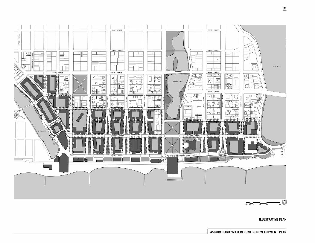
Asbury Park’s ocean frontage is the prime characteristic that differentiates it from other New Jersey cities. The basic objective of this plan is to take full advantage of the beach location through the creation of a new, year-round mixed use community in close proximity to the oceanfront. This community will contain housing, retail, entertainment and cultural facilities. The design character of this new community will be established through the creation of a beautiful network of public spaces. The open space network will include streets, parks, and pedestrian areas that will be defined, at their edges, by buildings with strong architectural quality.
History is an important part of this plan. Buildings with significant architectural character, such as the Casino, Heating Plant, Convention Hall and former Howard Johnson’s will be renovated for retail/entertainment use. Asbury Park’s national reputation as a focal point for rock-n-roll music will be an important component of an entertainment center located between the Casino and Stone Pony.
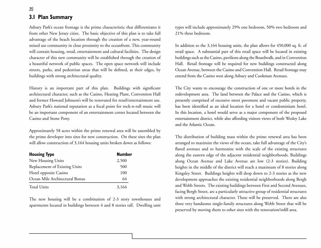
Approximately 58 acres within the prime renewal area will be assembled by the prime developer into sites for new construction. On these sites the plan will allow construction of 3,164 housing units broken down as follows:
Housing Type NumberNew Housing Units 2,500Replacement of Existing Units 500Hotel opposite Casino 100Ocean Mile Architectural Bonus 64
Total Units 3,164
The new housing will be a combination of 2-3 story townhouses and apartments located in buildings between 4 and 8 stories tall. Dwelling unit
types will include approximately 29% one bedroom, 50% two bedroom and 21% three bedroom.
In addition to the 3,164 housing units, the plan allows for 450,000 sq. ft. of retail space. A substantial part of this retail space will be located in existing buildings such as the Casino, pavilions along the Boardwalk, and in Convention Hall. Retail frontage will be required for new buildings constructed along Ocean Avenue, between the Casino and Convention Hall. Retail frontage may extend from the Casino west along Asbury and Cookman Avenues.
The City wants to encourage the construction of one or more hotels in the redevelopment area. The land between the Palace and the Casino, which is presently comprised of excessive street pavement and vacant public property, has been identified as an ideal location for a hotel or condominium hotel. In this location, a hotel would serve as a major component of the proposed entertainment district, while also affording visitors views of both Wesley Lake and the Atlantic Ocean.
The distribution of building mass within the prime renewal area has been arranged to maximize the views of the ocean, take full advantage of the City’s flared avenues and to harmonize with the scale of the existing structures along the eastern edge of the adjacent residential neighborhoods. Buildings along Ocean Avenue and Lake Avenue are low (2-3 stories). Building heights in the middle of the district will reach a maximum of 8 stories along Kingsley Street. Buildings heights will drop down to 2-3 stories as the new development approaches the existing residential neighborhoods along Bergh and Webb Streets. The existing buildings between First and Second Avenues, facing Bergh Street, are a particularly attractive group of residential structures with strong architectural character. These will be preserved. There are also three very handsome single-family structures along Webb Street that will be preserved by moving them to other sites with the renovation/infill area.
3.1 Plan Summary
21
ASBURY PARK WATERFRONT REDEVELOPMENT PLAN
ILLUSTRATIVE PLAN
NORTH2000100200 400 800
22
3.2 Open Space, Recreation, and Community Facilities
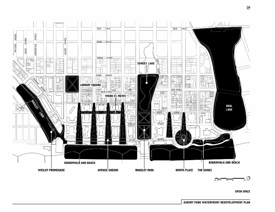
Open space and community facilities within the Waterfront Redevelopment Area will consist of several existing spaces, such as the Beach, Boardwalk, Bradley Park, Library Square, Sunset Lake, Deal Lake and Wesley Lake. There will also be additional open spaces that will be created through the design of the streets, the extension of the Boardwalk and the creation of new pedestrian routes. With the implementation of the Redevelopment Plan, open space will represent 19.2% of the Prime Renewal/Boardwalk area and 17.3% of the entire Waterfront Redevelopment Area.
Beach and Boardwalk Asbury Park’s beach and mile-long Boardwalk will continue to serve as the primary public open space within the Waterfront Redevelopment Area. A section of the Boardwalk has been renovated, but most of the Boardwalk surface and substructure is in very poor condition. The city recognizes that the Boardwalk must be in first class condition so as to help attract new development to the waterfront area and the city will take the steps necessary to reconstruct the remaining dilapidated sections. Public access will be maintained and enhanced through the extension of the sidewalks, which flank each of the east-west avenues, directly to the Boardwalk. Eighth Avenue, which has been interrupted by the placement of the wastewater treatment plant, will be linked to the Boardwalk through a single pedestrian path that will begin at Kingsley Street. Public arcades within the Casino and Convention Hall will be renovated to permit, and encourage, uninterrupted pedestrian movement along the Boardwalk.
Access to the majority of the Beach will be regulated through the use of beach tags. Exceptions to this will be the free beach, south of the Casino building, and the surf/sail beach. The surf/sail beach will be located at the north end of the public beach and will provide a place where activities such as surfing, kayaking and sailing may be conducted without conflicting with bathing. A new private beach club will be developed on the Boardwalk between Sixth
and Seventh Avenues, in a manner that will not limit pedestrian mobility along the Boardwalk. A public beach club will also be developed. The northern end of the Boardwalk will be extended to meet Ocean Avenue at Deal Lake. A new path will be constructed that will extend from Seventh Avenue to Deal Lake. This curvilinear path will be set at beach level and will provide barrier-free access along the beachfront. New dunes will be constructed to provide a backdrop of natural landforms and plantings that will also provide an enhanced degree of shoreline protection.
A public children’s pool area will be constructed, by the owner/developer of the private beach club, at the eastern terminus of Second Avenue, between Ocean Avenue and the Boardwalk. This will contain a small shallow pool for very small children and a larger wading pool, with a depth ranging from 2-4 feet. A generous concrete patio with decorative patterns and colors will surround these pools. Restrooms, changing rooms and a building to house mechanical equipment and maintenance materials will be constructed to serve the pool facility. As with all public facilities, it will be universally accessible.
Asbury Park has one of the oldest fishing clubs in the country. Access to the rock jetties will be maintained for the purposes of surf fishing. Support facilities, including washstands and disposal facilities, will be provided where it will be convenient for fisherman. These facilities will also located so that they are visible to the public, who will be able to watch as local fisherman measure, weigh and process their catch.
Bocce courts will be developed to continue the tradition of “lawn bowling” in Asbury Park. These will be lighted facilities located at the terminus of Sixth Avenue, between Ocean Avenue and the Boardwalk. Seating, drinking fountains, restrooms and sunshades will be provided.
The Casino and Convention Hall will be renovated and will serve as focal points for community events along the Boardwalk.
23
ASBURY PARK WATERFRONT REDEVELOPMENT PLAN
OPEN SPACE
NORTH2000100200 400 800
24
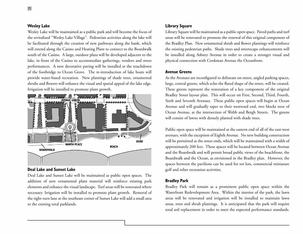
Wesley LakeWesley Lake will be maintained as a public park and will become the focus of the revitalized “Wesley Lake Village”. Pedestrian activities along the lake will be facilitated through the creation of new pathways along the bank, which will extend along the Casino and Heating Plant to connect to the Boardwalk south of the Casino. A large, outdoor plaza will be developed adjacent to the lake, in front of the Casino to accommodate gatherings, vendors and street performances. A new decorative paving will be installed at the touchdown of the footbridge to Ocean Grove. The re-introduction of lake boats will provide water-based recreation. New plantings of shade trees, ornamental shrubs and flowers will enhance the visual and spatial appeal of the lake edge. Irrigation will be installed to promote plant growth.
Deal Lake and Sunset LakeDeal Lake and Sunset Lake will be maintained as public open spaces. The addition of new ornamental plant material will reinforce existing park elements and enhance the visual landscape. Turf areas will be renovated where necessary. Irrigation will be installed to promote plant growth. Removal of the right-turn lane at the southeast corner of Sunset Lake will add a small area to the existing total parklands.
Library SquareLibrary Square will be maintained as a public open space. Paved paths and turf areas will be renovated to promote the renewal of this original component of the Bradley Plan. New ornamental shrub and flower plantings will reinforce the existing pedestrian paths. Shade trees and streetscape enhancements will be installed along Asbury Avenue in order to create a stronger visual and physical connection with Cookman Avenue the Oceanfront.
Avenue GreensAs the Avenues are reconfigured to delineate on-street, angled parking spaces, large, central greens, which echo the flared shape of the street, will be created. These greens represent the restoration of a key component of the original Bradley Street layout plan. This will occur on First, Second, Third, Fourth, Sixth and Seventh Avenues. These public open spaces will begin at Ocean Avenue and will gradually taper to their westward end, two blocks west of Ocean Avenue, at the intersection of Webb and Bergh Streets. The greens will consist of lawns with densely planted with shade trees.
Public open space will be maintained at the eastern end of all of the east-west avenues, with the exception of Eighth Avenue. No new building construction will be permitted at the street ends, which will be maintained with a width of approximately 200 feet. These spaces will be located between Ocean Avenue and the Boardwalk and will permit broad public views of the beachfront, the Boardwalk and the Ocean, as envisioned in the Bradley plan. However, the spaces between the pavilions can be used for tot lots, commercial miniature golf and other recreation activities.
Bradley Park Bradley Park will remain as a prominent public open space within the Waterfront Redevelopment Area. Within the interior of the park, the lawn areas will be renovated and irrigation will be installed to maintain lawn areas, trees and shrub plantings. It is anticipated that the park will require total soil replacement in order to meet the expected performance standards.
25
BEACHNORTH PLACE
BOARDWALK
AVENUE GREEN
DUNE
ASBURY PARK WATERFRONT REDEVELOPMENT PLAN
BRADLEY PARK
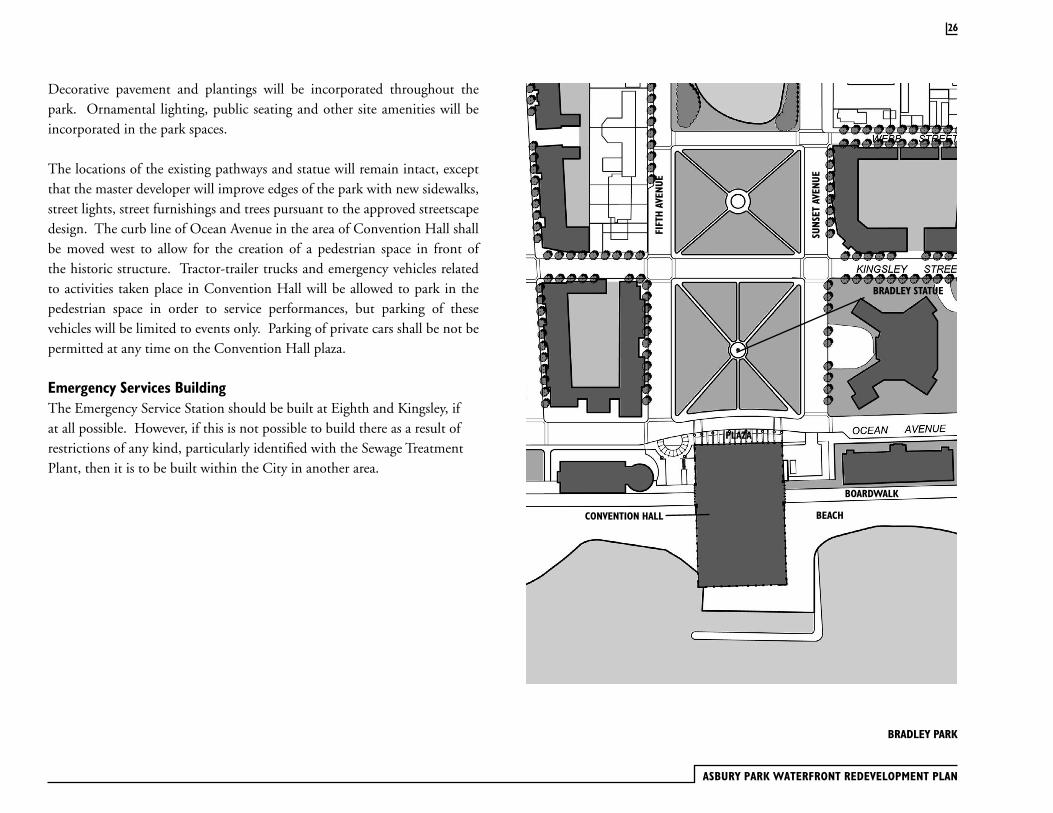
Decorative pavement and plantings will be incorporated throughout the park. Ornamental lighting, public seating and other site amenities will be incorporated in the park spaces.
The locations of the existing pathways and statue will remain intact, except that the master developer will improve edges of the park with new sidewalks, street lights, street furnishings and trees pursuant to the approved streetscape design. The curb line of Ocean Avenue in the area of Convention Hall shall be moved west to allow for the creation of a pedestrian space in front of the historic structure. Tractor-trailer trucks and emergency vehicles related to activities taken place in Convention Hall will be allowed to park in the pedestrian space in order to service performances, but parking of these vehicles will be limited to events only. Parking of private cars shall be not be permitted at any time on the Convention Hall plaza.
Emergency Services BuildingThe Emergency Service Station should be built at Eighth and Kingsley, if at all possible. However, if this is not possible to build there as a result of restrictions of any kind, particularly identified with the Sewage Treatment Plant, then it is to be built within the City in another area.
26
FIFT
H AV
ENUE
SUNS
ET A
VENU
E
BOARDWALK
BEACHCONVENTION HALL
PLAZA
BRADLEY STATUE

Convention Hall
Convention Hall was constructed in the late 1920’s based upon the design of Warren and Wetmore, architects with offices in Manhattan and Asbury Park. Warren and Wetmore were also the designers of Grand Central Station in New York. The building was conceived as a modern facility for the accommodation of cultural events, ranging from motion pictures and concerts in the Paramount Theatre to exhibitions and larger entertainment events in the Hall. A skylight arcade over the Boardwalk between the Paramount Theatre and the Hall contained a variety of tourist-oriented shops and places to eat.
For many years, Convention Hall hosted performances by world famous entertainers, ranging from the biggest of the big bands to the most popular of rock groups. The Hall has been home for many trade shows each year, as well as folk festivals, cotillions and religious revivals.
Under the Waterfront Redevelopment Plan, the developer will acquire Convention Hall from the City, renovate the building and operate it as an entertainment and cultural facility.
The Historic Preservation Element of Asbury Park’s Master Plan describes the places and buildings within the Waterfront Redevelopment Area that are significant and should be preserved. The most influential historic element in the renewal area is the formal street and open space plan conceived by James Bradley. Bradley’s Plan for Asbury Park was surveyed by Frederick and Isaac Kennedy, the same surveyors who were responsible for Ocean Grove. The City’s master plan points out that Bradley’s original plan should be viewed as a historic asset worthy of preservation, and lists the plan’s main attributes:
· The grid street pattern and many of the street names, chosen for leaders of Methodism in America. These include Asbury Avenue, Emory Street, Bond Street and Kingsley Street.
· The flared street design, gradually widening to 200 feet at Ocean Avenue. The intent of this original design, although modified somewhat east of Kingsley Street by the original Waterfront Redevelopment Plan, exists from First Avenue to Sunset Avenues, and on Seventh Avenue.
· The beachfront, with its parallel Boardwalk structure lined with pavilions and major buildings devoted to cultural activities and entertainment.
· Wesley Lake, with surrounding parklands and the two footbridges that cross the Lake, connecting Asbury Park to Ocean Grove.
· The open space corridor formed by Sunset Lake and Park, Atlantic Square Park and Bradley Park.
· Deal Lake and surrounding parklands.
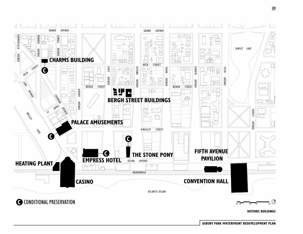
The City’s Historic Preservation element identifies three buildings within the Waterfront Redevelopment Area that are either listed or eligible to be listed on the National Register of Historic Places: Convention Hall, the Casino/Heating Plant and the Palace Amusement building. Renovation of historic structures will be carried out in a manner that is consistent and in compliance with all applicable Federal and State statutes.
3.3 Historic and/or Significant Buildings
27
ASBURY PARK WATERFRONT REDEVELOPMENT PLAN
SIXTH AVENUE
SEVENTH AVENUE
EIGHTH AVENUE
FIFTH AVENUE
SUNSET AVENUE
SUNSET L AKE
DEAL LAKE DRIVE
GRAND AVENUE
SUNSET AVENUE
FOURTH AVENUE
SECOND AVENUE
THIRD AVENUE
HECK STREET
KINGSLEY STREET
ASBURY AVENUE
COOKMAN AVENUEST. JA
MES
SEWALL AVENUE
MONROE AVENUE
SUMMERFIELD AVENUE
EMORY STREET
LAKE AVENUE
BERGH STREET
FIRST AVENUE
WEBB STREET
OCEAN AVENUE
GRAND AVENUE
PARK AVENUE
EMORY STREET
OCEAN AVENUE
WESLEY L AKE
BOND STREET
MAIN STREET
NEW YORK & LONG BRANCH RAILROAD CO.
BOND STREET
MAIN STREET
BANGS AVENUE
MATTISON AVENUE
GRAND AVENUE
OCEANGROVE
BOARDWALKBOARDWALK
ATL ANTIC OCEAN
ATL ANTIC OCEAN
HECK STREET
BERGH STREET
DEAL L AKE
CHARMS BUILDING
PALACE AMUSEMENTS
CASINO
HEATING PLANTTHE STONE PONY
CONVENTION HALL
FIFTH AVENUE PAVILION
CONDITIONAL PRESERVATION
EMPRESS HOTEL
C
C
C C
C
BERGH STREET BUILDINGS
HISTORIC BUILDINGS
NORTH2000100200 400 800
28
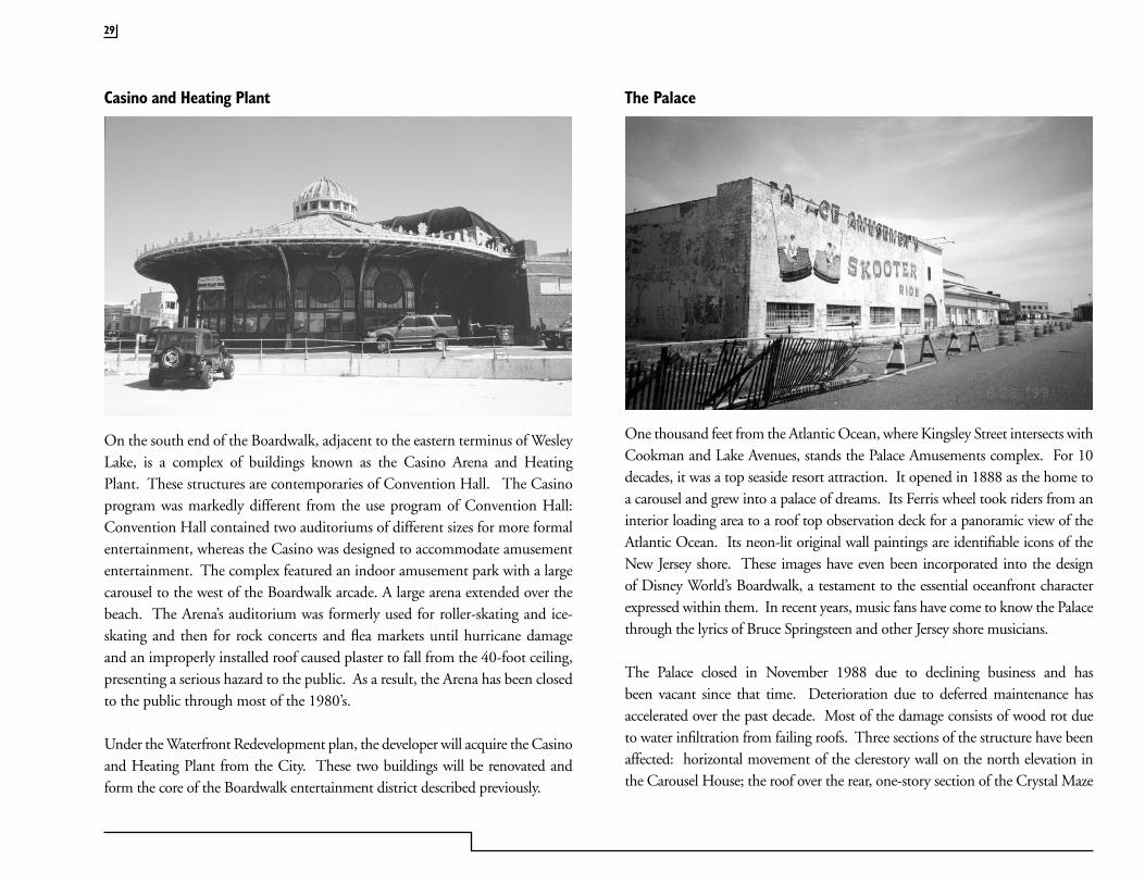
Casino and Heating Plant
On the south end of the Boardwalk, adjacent to the eastern terminus of Wesley Lake, is a complex of buildings known as the Casino Arena and Heating Plant. These structures are contemporaries of Convention Hall. The Casino program was markedly different from the use program of Convention Hall: Convention Hall contained two auditoriums of different sizes for more formal entertainment, whereas the Casino was designed to accommodate amusement entertainment. The complex featured an indoor amusement park with a large carousel to the west of the Boardwalk arcade. A large arena extended over the beach. The Arena’s auditorium was formerly used for roller-skating and ice-skating and then for rock concerts and flea markets until hurricane damage and an improperly installed roof caused plaster to fall from the 40-foot ceiling, presenting a serious hazard to the public. As a result, the Arena has been closed to the public through most of the 1980’s.
Under the Waterfront Redevelopment plan, the developer will acquire the Casino and Heating Plant from the City. These two buildings will be renovated and form the core of the Boardwalk entertainment district described previously.
The Palace
One thousand feet from the Atlantic Ocean, where Kingsley Street intersects with Cookman and Lake Avenues, stands the Palace Amusements complex. For 10 decades, it was a top seaside resort attraction. It opened in 1888 as the home to a carousel and grew into a palace of dreams. Its Ferris wheel took riders from an interior loading area to a roof top observation deck for a panoramic view of the Atlantic Ocean. Its neon-lit original wall paintings are identifiable icons of the New Jersey shore. These images have even been incorporated into the design of Disney World’s Boardwalk, a testament to the essential oceanfront character expressed within them. In recent years, music fans have come to know the Palace through the lyrics of Bruce Springsteen and other Jersey shore musicians.
The Palace closed in November 1988 due to declining business and has been vacant since that time. Deterioration due to deferred maintenance has accelerated over the past decade. Most of the damage consists of wood rot due to water infiltration from failing roofs. Three sections of the structure have been affected: horizontal movement of the clerestory wall on the north elevation in the Carousel House; the roof over the rear, one-story section of the Crystal Maze
29
ASBURY PARK WATERFRONT REDEVELOPMENT PLAN
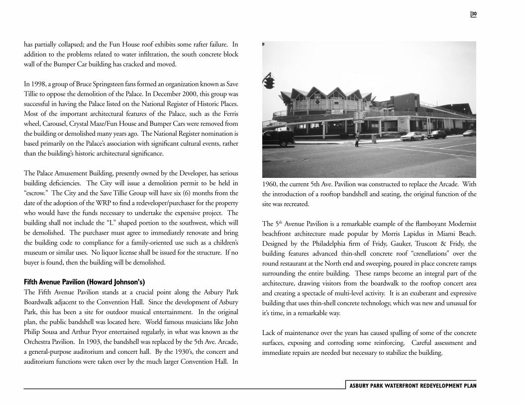
1960, the current 5th Ave. Pavilion was constructed to replace the Arcade. With the introduction of a rooftop bandshell and seating, the original function of the site was recreated.
The 5th Avenue Pavilion is a remarkable example of the flamboyant Modernist beachfront architecture made popular by Morris Lapidus in Miami Beach. Designed by the Philadelphia firm of Fridy, Gauker, Truscott & Fridy, the building features advanced thin-shell concrete roof “crenellations” over the round restaurant at the North end and sweeping, poured in place concrete ramps surrounding the entire building. These ramps become an integral part of the architecture, drawing visitors from the boardwalk to the rooftop concert area and creating a spectacle of multi-level activity. It is an exuberant and expressive building that uses thin-shell concrete technology, which was new and unusual for it’s time, in a remarkable way.
Lack of maintenance over the years has caused spalling of some of the concrete surfaces, exposing and corroding some reinforcing. Careful assessment and immediate repairs are needed but necessary to stabilize the building.
has partially collapsed; and the Fun House roof exhibits some rafter failure. In addition to the problems related to water infiltration, the south concrete block wall of the Bumper Car building has cracked and moved.
In 1998, a group of Bruce Springsteen fans formed an organization known as Save Tillie to oppose the demolition of the Palace. In December 2000, this group was successful in having the Palace listed on the National Register of Historic Places. Most of the important architectural features of the Palace, such as the Ferris wheel, Carousel, Crystal Maze/Fun House and Bumper Cars were removed from the building or demolished many years ago. The National Register nomination is based primarily on the Palace’s association with significant cultural events, rather than the building’s historic architectural significance.
The Palace Amusement Building, presently owned by the Developer, has serious building deficiencies. The City will issue a demolition permit to be held in “escrow.” The City and the Save Tillie Group will have six (6) months from the date of the adoption of the WRP to find a redeveloper/purchaser for the property who would have the funds necessary to undertake the expensive project. The building shall not include the “L” shaped portion to the southwest, which will be demolished. The purchaser must agree to immediately renovate and bring the building code to compliance for a family-oriented use such as a children’s museum or similar uses. No liquor license shall be issued for the structure. If no buyer is found, then the building will be demolished.
Fifth Avenue Pavilion (Howard Johnson’s)The Fifth Avenue Pavilion stands at a crucial point along the Asbury Park Boardwalk adjacent to the Convention Hall. Since the development of Asbury Park, this has been a site for outdoor musical entertainment. In the original plan, the public bandshell was located here. World famous musicians like John Philip Sousa and Arthur Pryor entertained regularly, in what was known as the Orchestra Pavilion. In 1903, the bandshell was replaced by the 5th Ave. Arcade, a general-purpose auditorium and concert hall. By the 1930’s, the concert and auditorium functions were taken over by the much larger Convention Hall. In
30
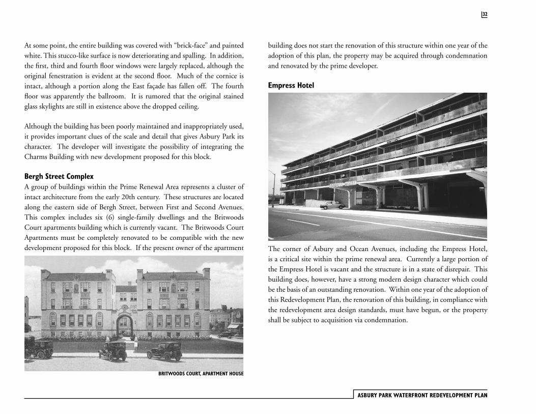
Charms Building
The Charm’s Building stands at the corner of Monroe Avenue and Heck Street and is one of the few remaining historic buildings in the immediate area. Standing four stories, it is a proud neo-classical structure built in 1923 as the Elks Building for BPOE 128. In the 1940’s the building was sold and came to be knows as the Charm’s Building because the famous candy company used the structure for offices and distribution. The building’s ground floor has simple storefronts for retail use. The second floor has grand, elaborately fenestrated arched openings. Both of the upper floors have smaller arched openings; the third and fourth floors are separated by a drip course. The building is capped with an elaborate copper cornice and a masonry balustrade.
The East side of the building is enlivened by two copper projecting bays (now painted) that span between the second and third floors. A small projecting balcony at the third floor and a flagpole marks the center of the South facade. Masonry pilasters project to emphasize the corners of this handsome building.
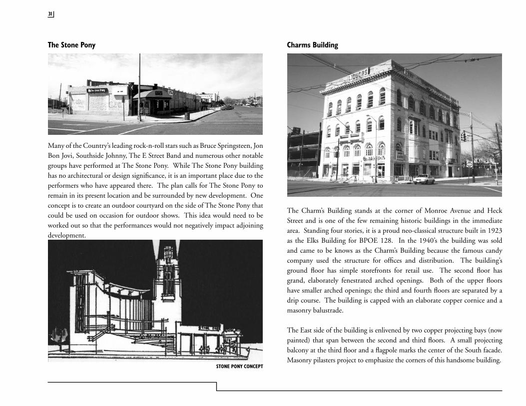
The Stone Pony
Many of the Country’s leading rock-n-roll stars such as Bruce Springsteen, Jon Bon Jovi, Southside Johnny, The E Street Band and numerous other notable groups have performed at The Stone Pony. While The Stone Pony building has no architectural or design significance, it is an important place due to the performers who have appeared there. The plan calls for The Stone Pony to remain in its present location and be surrounded by new development. One concept is to create an outdoor courtyard on the side of The Stone Pony that could be used on occasion for outdoor shows. This idea would need to be worked out so that the performances would not negatively impact adjoining development.
STONE PONY CONCEPT
31
ASBURY PARK WATERFRONT REDEVELOPMENT PLAN
At some point, the entire building was covered with “brick-face” and painted white. This stucco-like surface is now deteriorating and spalling. In addition, the first, third and fourth floor windows were largely replaced, although the original fenestration is evident at the second floor. Much of the cornice is intact, although a portion along the East façade has fallen off. The fourth floor was apparently the ballroom. It is rumored that the original stained glass skylights are still in existence above the dropped ceiling.
Although the building has been poorly maintained and inappropriately used, it provides important clues of the scale and detail that gives Asbury Park its character. The developer will investigate the possibility of integrating the Charms Building with new development proposed for this block.
Bergh Street Complex A group of buildings within the Prime Renewal Area represents a cluster of intact architecture from the early 20th century. These structures are located along the eastern side of Bergh Street, between First and Second Avenues. This complex includes six (6) single-family dwellings and the Britwoods Court apartments building which is currently vacant. The Britwoods Court Apartments must be completely renovated to be compatible with the new development proposed for this block. If the present owner of the apartment
32
BRITWOODS COURT, APARTMENT HOUSE
building does not start the renovation of this structure within one year of the adoption of this plan, the property may be acquired through condemnation and renovated by the prime developer.
Empress Hotel
The corner of Asbury and Ocean Avenues, including the Empress Hotel, is a critical site within the prime renewal area. Currently a large portion of the Empress Hotel is vacant and the structure is in a state of disrepair. This building does, however, have a strong modern design character which could be the basis of an outstanding renovation. Within one year of the adoption of this Redevelopment Plan, the renovation of this building, in compliance with the redevelopment area design standards, must have begun, or the property shall be subject to acquisition via condemnation.
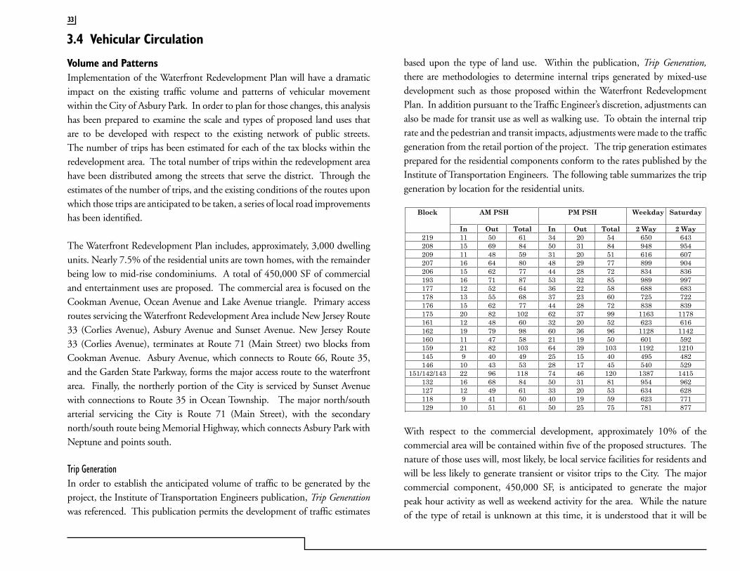
based upon the type of land use. Within the publication, Trip Generation, there are methodologies to determine internal trips generated by mixed-use development such as those proposed within the Waterfront Redevelopment Plan. In addition pursuant to the Traffic Engineer’s discretion, adjustments can also be made for transit use as well as walking use. To obtain the internal trip rate and the pedestrian and transit impacts, adjustments were made to the traffic generation from the retail portion of the project. The trip generation estimates prepared for the residential components conform to the rates published by the Institute of Transportation Engineers. The following table summarizes the trip generation by location for the residential units.
With respect to the commercial development, approximately 10% of the commercial area will be contained within five of the proposed structures. The nature of those uses will, most likely, be local service facilities for residents and will be less likely to generate transient or visitor trips to the City. The major commercial component, 450,000 SF, is anticipated to generate the major peak hour activity as well as weekend activity for the area. While the nature of the type of retail is unknown at this time, it is understood that it will be
AM PSH PM PSH Weekday SaturdayBlock
In Out Total In Out Total 2 Way 2 Way 219 11 50 61 34 20 54 650 643 208 15 69 84 50 31 84 948 954 209 11 48 59 31 20 51 616 607 207 16 64 80 48 29 77 899 904 206 15 62 77 44 28 72 834 836 193 16 71 87 53 32 85 989 997 177 12 52 64 36 22 58 688 683 178 13 55 68 37 23 60 725 722 176 15 62 77 44 28 72 838 839 175 20 82 102 62 37 99 1163 1178 161 12 48 60 32 20 52 623 616 162 19 79 98 60 36 96 1128 1142 160 11 47 58 21 19 50 601 592 159 21 82 103 64 39 103 1192 1210 145 9 40 49 25 15 40 495 482 146 10 43 53 28 17 45 540 529
151/142/143 22 96 118 74 46 120 1387 1415 132 16 68 84 50 31 81 954 962 127 12 49 61 33 20 53 634 628 118 9 41 50 40 19 59 623 771 129 10 51 61 50 25 75 781 877
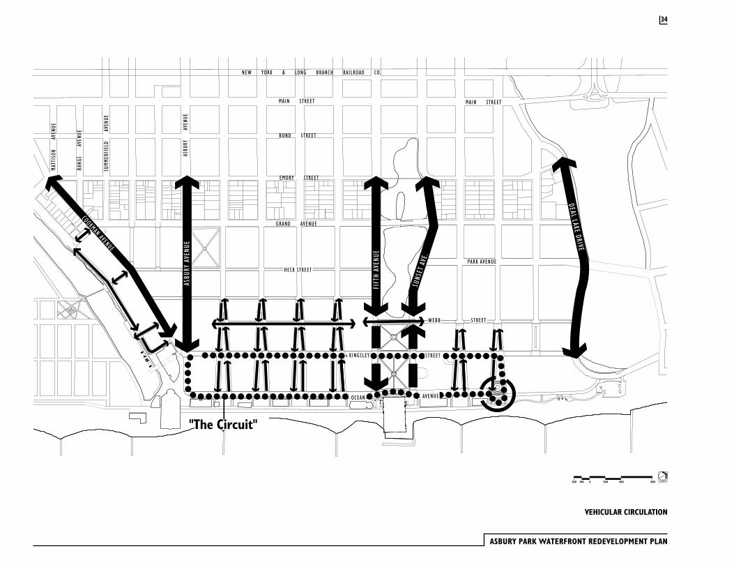
3.4 Vehicular Circulation
Volume and PatternsImplementation of the Waterfront Redevelopment Plan will have a dramatic impact on the existing traffic volume and patterns of vehicular movement within the City of Asbury Park. In order to plan for those changes, this analysis has been prepared to examine the scale and types of proposed land uses that are to be developed with respect to the existing network of public streets. The number of trips has been estimated for each of the tax blocks within the redevelopment area. The total number of trips within the redevelopment area have been distributed among the streets that serve the district. Through the estimates of the number of trips, and the existing conditions of the routes upon which those trips are anticipated to be taken, a series of local road improvements has been identified.
The Waterfront Redevelopment Plan includes, approximately, 3,000 dwelling units. Nearly 7.5% of the residential units are town homes, with the remainder being low to mid-rise condominiums. A total of 450,000 SF of commercial and entertainment uses are proposed. The commercial area is focused on the Cookman Avenue, Ocean Avenue and Lake Avenue triangle. Primary access routes servicing the Waterfront Redevelopment Area include New Jersey Route 33 (Corlies Avenue), Asbury Avenue and Sunset Avenue. New Jersey Route 33 (Corlies Avenue), terminates at Route 71 (Main Street) two blocks from Cookman Avenue. Asbury Avenue, which connects to Route 66, Route 35, and the Garden State Parkway, forms the major access route to the waterfront area. Finally, the northerly portion of the City is serviced by Sunset Avenue with connections to Route 35 in Ocean Township. The major north/south arterial servicing the City is Route 71 (Main Street), with the secondary north/south route being Memorial Highway, which connects Asbury Park with Neptune and points south.
Trip GenerationIn order to establish the anticipated volume of traffic to be generated by the project, the Institute of Transportation Engineers publication, Trip Generation was referenced. This publication permits the development of traffic estimates
33
ASBURY PARK WATERFRONT REDEVELOPMENT PLAN
VEHICULAR CIRCULATION
NORTH2000100200 400 800
34
HECK STREET
KINGSLEY STREET
OCEAN AVENUE
WEBB STREET
ASBURYAVENUE
FIFTHAVENUE
DEALL AKE
DRIVE
SUNSETAVE.
COOKMAN AVENUE
"The Circuit"
GRAND AVENUE
SUMMERFIELD
AVENUE
ASBURY
AVENUE
EMORY STREET
BOND STREET
MAIN STREET
NEW YORK & LONG BRANCH RAILROAD CO.
MAIN STREET
BANGS
AVENUE
MATTISON
AVENUE
PARK AVENUE
a combination of retail and recreational/amusement type uses. These latter uses could include boardwalk-type entertainment, such as games, amusement activities and food service. In order to perform a conservative analysis- that is to overestimate the traffic generation in order to create a margin for error- we have utilized retail trip generation rates, which have been adjusted by 5% for walk in/local trade and 10% for the internal trips from the residences that are to be constructed. The following table represents the anticipated weekday and weekend peak hour volumes for the retail portion of the facility:
It should be noted that there have been no adjustments to site-generated traffic for the retail component due to pass-by trips. This is due to the destination nature of the redevelopment area and its location with respect to major vehicular thoroughfares. Pass-by trips would, in fact, be link-diverted trips from such routes as Route 71.
Trip DistributionA review of the Monmouth County census data indicates that the majority of residents work within the County, with approximately 35% working out of the County. It is anticipated that the future residents will exhibit similar employment traits as current Monmouth County residents. Accordingly, it is estimated that 15% of the trips will be generated to and from the north on Route 71 (Main Street); approximately 2% southbound on Route 71 (Main Street); 3% via mass transit; and 80% anticipated to exit westerly towards Route 33, the Garden State Parkway, and Route 35. Asbury Avenue, because of its convenience and ease of access, will be the primary access route. Route 33 will be the secondary route for entering and exiting the City from the west. Currently Route 33 is slated for improvement by the New Jersey Department
AM PSH PM PSH SAT PSH In Out Total In Out Total In Out Total
DAILY2 WAY
220 140 360 625 675 1300 900 830 1750 14950
of Transportation. Major improvements will made at the intersection of Route 35 and Route 71 to accommodate left turning traffic from Route 33. Three approach lanes are proposed. At each of the signalized intersections between Route 71 and Route 35, multi-lane approaches will be provided in order to improve capacity. New traffic signals will also be installed at key intersections as part of the Department of Transportation approvals. Construction of the project is anticipated to begin in fiscal year 2004 and be completed within two years. Asbury Avenue, a two-lane roadway, has historically been the major access point into the City for recreational and daily traffic activity. The additional traffic generated by the redevelopment area is anticipated to create demands for retiming and adjustment of existing traffic signal operation. The signal system along Asbury Avenue should be adjusted to reflect peak inbound and outbound traffic flows on weekdays and weekends, with cycle lengths and timing offsets adjusted accordingly. It is also anticipated that certain intersections will require re-striping for multi-lane approaches. The following summarizes the anticipated modifications to Asbury Avenue:
· Establish a computerized signal system to facilitate peak inbound/outbound and summer traffic flows as previously existed along Asbury Avenue.
· At key intersections such as Memorial Drive and Route 71, re-stripe the intersections to provide two approach lanes and prohibit parking where appropriate.
· Coordinate signage to Asbury Park with New Jersey Department of Transportation and New Jersey Highway Authority.
· In residential areas, along Asbury Avenue, provide for improved pedestrian safety.
35
ASBURY PARK WATERFRONT REDEVELOPMENT PLAN
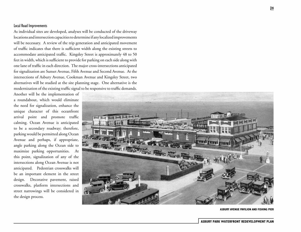
Local Road ImprovementsAs individual sites are developed, analyses will be conducted of the driveway locations and intersection capacities to determine if any localized improvements will be necessary. A review of the trip generation and anticipated movement of traffic indicates that there is sufficient width along the existing streets to accommodate anticipated traffic. Kingsley Street is approximately 48 to 50 feet in width, which is sufficient to provide for parking on each side along with one lane of traffic in each direction. The major cross-intersections anticipated for signalization are Sunset Avenue, Fifth Avenue and Second Avenue. At the intersections of Asbury Avenue, Cookman Avenue and Kingsley Street, two alternatives will be studied at the site planning stage. One alternative is the modernization of the existing traffic signal to be responsive to traffic demands. Another will be the implementation of a roundabout, which would eliminate the need for signalization, enhance the unique character of this oceanfront arrival point and promote traffic calming. Ocean Avenue is anticipated to be a secondary roadway; therefore, parking would be permitted along Ocean Avenue and perhaps, if appropriate, angle parking along the Ocean side to maximize parking opportunities. At this point, signalization of any of the intersections along Ocean Avenue is not anticipated. Pedestrian crosswalks will be an important element in the street design. Decorative pavement, raised crosswalks, platform intersections and street narrowings will be considered in the design process.
36
ASBURY AVENUE PAVILION AND FISHING PIER
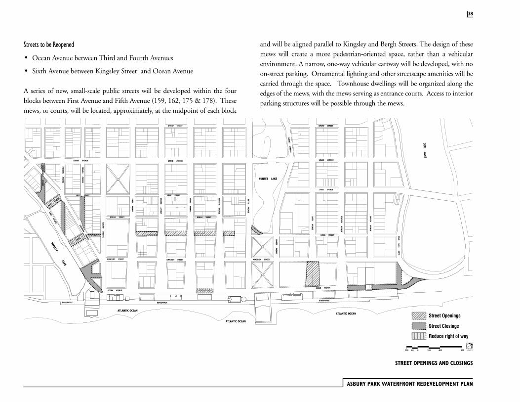
Street Closings and OpeningThe overall goal of this plan is to preserve and enhance the original 1877 street plan designed by James Bradley. In the 1877 plan, the street grid was turned to reflect the angled edge of Wesley Lake. This shift in the grid created a number of small triangular blocks on either side of Cookman Avenue. These small blocks make housing development difficult. Additionally, their configuration does not result in an optimal relationship between these upland parcels and Wesley Lake. In order to correct this situation, four block lengths of streets in the Lake District will be vacated by the City. Certain street cartways will be reduced in width. Vacated street rights-of-way will be turned over to adjoining property owners for development pursuant to the redevelopment plan.
At the north end of the renewal area, the blocks of Ocean Avenue on either side of the Asbury Park Sewerage Treatment Plan will be identified as development sites. The placement of new construction at this location will provide visual screening of the wastewater treatment plant from the public rights-of-way.
Sections of Streets to be Vacated
· Summerfield Avenue between Grand Avenue and Cookman Avenue
· Summerfield Avenue between Cookman Avenue and Lake Avenue
· Heck Street between Cookman Avenue and Lake Avenue
· Monroe Avenue between Cookman Avenue and Lake Avenue
· St James Place between Cookman Avenue and Lake Avenue
· Kingsley Street between Cookman Avenue and Lake Avenue
· Sewall Avenue between Heck Street and Cookman Avenue
· Bergh Street between Asbury Avenue and Cookman Avenue
· Ocean Avenue between Seventh Avenue and Asbury Park Sewerage Treatment plant
· Ocean Avenue north of Asbury Park wastewater treatment plant to Deal Lake Drive
· Right turn lane between Webb Street and Fifth Avenue by Sunset Lake
The 1984 plan for the Waterfront Redevelopment Area included provisions to close Ocean Avenue to traffic and combine the development blocks between Ocean Avenue and Kingsley Street with the Boardwalk building sites. This plan amendment repeals the street closing of Ocean Avenue except for the portion of Ocean Avenue between Seventh Avenue and the Asbury Park wastewater treatment plant and the section of Ocean Avenue between the wastewater treatment plant and Deal Lake Drive. The developer of Block 176, which contains the uncompleted high rise condominium, will trim the east side of the structure back in order to allow Ocean Avenue to return to its former, historic width between Third and Fourth Avenues. The section of Ocean Avenue right-of-way that was transferred to the Block 176 condominium developer shall be deeded back to the City.
The 1984 plan for the closing of Ocean Avenue included a complementary proposal to increase the right-of-way width of Kingsley Street to accommodate the displaced traffic. This plan amendment repeals the plan to increase the width of Kingsley Street. The City of Asbury Park will transfer, back to the developer, the section of Kingsley Street (between Third and Forth Avenues) that was taken in order to increase the right-of-way of Kingsley Street.
Under previous versions of the Waterfront Redevelopment Plan the portion of Sixth Avenue between Kingsley Street and Ocean Avenue was vacated to allow for development within this right-of-way. This plan amendment requires that Sixth Avenue, between Kingsley Street and Ocean Avenue, be restored as a public street and opened to traffic. The developer of Block 207 shall transfer, to the City, the section of the Sixth Avenue, which was made a part of that development block. The section of the Sixth Avenue right-of-way, which was made a part of the Berkley-Carteret Hotel lands (Block 192), may be acquired by the City through negotiation or eminent domain.
37
ASBURY PARK WATERFRONT REDEVELOPMENT PLAN
STREET OPENINGS AND CLOSINGS
Streets to be Reopened
· Ocean Avenue between Third and Fourth Avenues
· Sixth Avenue between Kingsley Street and Ocean Avenue
A series of new, small-scale public streets will be developed within the four blocks between First Avenue and Fifth Avenue (159, 162, 175 & 178). These mews, or courts, will be located, approximately, at the midpoint of each block
and will be aligned parallel to Kingsley and Bergh Streets. The design of these mews will create a more pedestrian-oriented space, rather than a vehicular environment. A narrow, one-way vehicular cartway will be developed, with no on-street parking. Ornamental lighting and other streetscape amenities will be carried through the space. Townhouse dwellings will be organized along the edges of the mews, with the mews serving as entrance courts. Access to interior parking structures will be possible through the mews.
NORTH2000100200 400 800
38
Street Closings
Street Openings
Reduce right of way
SIXTHAVENUE
SEVENTHAVENUE
EIGHTHAVENUE
FIFTHAVENUE
SUNSETAVENUE
SUNSET LAKE
DEALLAKE
DRIVE
GRAND AVENUE
SUNSETAVENUE
FOURTHAVENUE
SECONDAVENUE
THIRDAVENUE
HECK STREET
KINGSLEY STREET
ASBURYAVENUE
COOKMAN
AVENUE
ST.JAMES
SEWALL
AVENUE
MONROE
AVENUE
SUMMERFIELD
AVENUE
EMORY STREET
LAKEAVENUE
BERGH STREET
FIRSTAVENUE
WEBB STREET
OCEAN AVENUE
GRAND AVENUE
PARK AVENUE
EMORY STREET
KINGSLEY STREET
OCEAN AVENUE
WESLEY
LAKE
BOND STREET
MAIN STREET
NEW YORK & LONG BRANCH RAILROAD CO.
BOND STREET
MAIN STREET
BANGSAVENUE
MATTISON
AVENUE
GRAND AVENUE
OCEANGROVE
ATLANTIC OCEAN
BOARDWALK BOARDWALKBOARDWALK
ATLANTIC OCEAN
ATLANTIC OCEAN
HECK STREET
HECK
STREET
BERGH STREET
KINGSLEY STREET
DEALLAKE
ST. JAMES
ThoroughfaresThoroughfare is the urban element that provides the major part of the public space as well as moving lanes for vehicles. A thoroughfare is endowed with two attributes: capacity and character. Capacity is the number of vehicles that can move safely through a segment of a thoroughfare within a given time period. It is physically manifested by the number of lanes and their width, by the center line radius, the curb radius, and the super elevation of the pavement. Character is the suitability of a thoroughfare as a setting for pedestrian activities and as a location for a variety of building types.
In many redevelopment plans, vehicular capacity is made the overriding consideration in the design of thoroughfares. This plan strikes a balance between capacity and character. The waterfront is a destination and, consequently, through traffic is not an issue. The goal is to have traffic move at a slow speed giving motorist ample opportunity to see storefronts and other neighborhood attractions. On-street parking will help to slow auto traffic so that it is compatible with pedestrian traffic. Generous sidewalks with street trees, handsome lamp posts, bicycle racks, and street furniture will make the Waterfront Redevelopment Area’s thoroughfares attractive places to walk.
When James Bradley designed Asbury Park, he made the City’s streets relatively wide. As illustrated in other sections of this plan, these broad thoroughfares can accommodate generous sidewalks, parking lanes and appropriate sized traffic
39
lanes. The width of the streets and avenues in the waterfront area will comfortably accommodate the mid-rise buildings which are proposed in the plan. Taller buildings, up to 8 stories, are located on corners along Kingsley Street.
Traffic Calming and Pedestrian MobilityEach thoroughfare in the Waterfront Redevelopment Area should contribute to the walkable, livable character of the redevelopment area.
These thoroughfares are not near the arterial highways that carry long distance travel between cities on the New Jersey coast. Even the collector network is removed from this oceanfront recreation area. Although many auto trips will occur, a high proportion of pedestrian, bike and transit trips are envisioned by both citizens and elected officials. A balance of all modes, specifically walking, is a major goal for State and City officials. Once these goals of walkability and livability are established, it is the responsibility of designers and review officials to assist in achieving this important community vision. As stated in Chapter 1 of the AASHTO Green Book regarding street design:
The functional concept is important to the designer. Even though many of the geometric design values could be determined without reference to the functional classification, the designer must keep in mind the overall purpose that the street or highway is intended to serve. This concept is consistent with a systematic approach to highway planning and design.
Passage: A pedestrian connector passing between two buildings. Passages provide shortcuts through long blocks and connect rear parking areas with street frontages. Passages may be roofed over and lined by shopfronts.
Alley: A narrow vehicular access way to the rear of more urban lots providing service areas, parking access, and utility easements. Alleys, as they are used by trucks and must accommodate dumpsters, should be paved from building face to building face, with drainage by inverted crown at the center.
ASBURY PARK WATERFRONT REDEVELOPMENT PLAN
40
Pedestrian safety requires lower motor vehicle speeds. A report published by the Institute of Transportation Engineers shows the increase in fatalities as speed increases. A vehicle speed increase from 30 to 40 mph doubles the probability of a pedestrian dying it struck by a motor vehicle. An increase from 20 to 30 mph raises the probability from 5% to over 40%. Street performance data collected by Peter Swift, P.E. shows an increase in the rate of vehicle crashes with expanding roadway width. His analysis of 20,000 crashes in Longmont, Colorado showed an exponential increase in crash rates with street increased width.
Design SpeedThe purpose and function of Oceanfront Asbury’s streets is to provide mobility for pedestrians, cyclists, transit patrons and vehicle drivers. Pedestrians are the most vulnerable and thus require the most care in the design process. Design of a thoroughfare that is comfortable and safe for pedestrians requires speeds in the range of 20 to 30 mph.
To realistically achieve a 25 mph design speed requires several key design elements. First, curbside parking increases the driver awareness that pedestrians are likely to be present. Second, narrower lane widths that do not allow wandering and careless inattention by drivers also require extra care and result in lower driving speeds.
The expansion of roadway widths during the last 50 years was generated, in part, by rural roadway safety research that showed roadside hazards as dangerous. Agencies then required clear zones to prevent roadside crashes. Although this concept is valid in high speed rural settings, in low speed urban settings, wide clearances tend to increase speed, thus yielding less safety for motorist and pedestrian. A balance of pedestrian and vehicle priority in design is only now beginning to occur in movements such as “context sensitive design” and New Urbanism.
The 2001, 4th Edition of the American Association of State Highway and Transportation Officials, Policies on Geometric Design of Highways and Streets, states that 10 foot driving lanes are acceptable in local conditions such as Asbury Park. More importantly, the safety record of local streets such as Main Street in neighboring Ocean Grove, demonstrates the reality of responsible street design that supports walking. The 20 foot sidewalks, 16 foot deep angle parking bays and 12 foot lanes assure the 20 mph speeds observed there.
Bicycle MobilityGood urban design and good transportation planning both call for increased mobility for the bicycle. Recreational use and destination travel by all modes
Street: A slow-movement thoroughfare suitable for General, Center, and Core Urban Zones. Streets provide frontage for higher-density buildings such as offices, shops, apartment buildings, and rowhouses. A street is urban in character, with raised curbs, closed drainage, wide sidewalks, parallel parking, and trees in individual planting areas. Character may vary somewhat, however, responding to the enfronting commercial and residential uses.
Drive: A thoroughfare along the boundary between an urbanized and a civic space. The urbanized side of a drive retains the character of a typical thoroughfare within that zone, while the other side should be designed as part of the adjacent civic space.
other than the auto are strongly encouraged. Bike lanes are needed along higher speed urban thoroughfares where cyclists are not physically able to maintain the speed of automobiles and trucks. Where posted speeds are 25 mph, or less, bicyclists are very comfortable riding in the main travel lanes with motorized vehicles. The document Designing New Jersey, defines 25 mph as a good design speed in neighborhoods where walking is a priority mode. With comfortable, low speed streets planned for the Redevelopment Area (east of Grand Ave.), bicyclists essentially have all streets in this fine grid network available for their safe use. Design and posted speeds should be the same in low speed walkable areas.
Cyclists are carefully considered and will be accommodated in the area streets. Since pedestrian scale is the critical design assumption for all roadways in the redevelopment area and these speeds will be set at 25 mph, no separate bike paths or bike lanes are needed to serve bicycle needs.
Commercial Street: A slow-movement thoroughfare suitable for Center and Core Urban Zones, providing frontage for higher-density mixed-use buildings such as shophouses, shops, and offices. It is urban in character with raised curbs, storm-drain inlets, and striped on-street parking. A single species of trees, planted in opportunistic alignment and confined by individual planters, create a sidewalk of maximum width, with areas accommodating street furniture.
Avenue: A slow-movement thoroughfare suitable for General, Center, and Core Urban Zones. Avenues are appropriate as approaches to civic buildings. The general principle is that of an elongated plaza. The median may be wide enough to hold monuments or even buildings. In residential areas, the median may be wider and planted naturalistically to become a greenway.
41
Thoroughfare DesignationsTraffic calming is the reduction of automobile speeds through the design of the roadway. The reduction in automobile speeds results in less noise and fumes, fewer accidents, and accidents that are less severe. These characteristics have the beneficial effect of making streets safer and more habitable for pedestrians. Traffic calming represents the most recent thinking in street design: streets are primarily spaces for pedestrians and that vehicles are secondary users. Pedestrian-oriented street design is supported by the New Jersey Office of State Planning publication Designing New Jersey and is gaining broader acceptance with transportation agencies throughout the country.
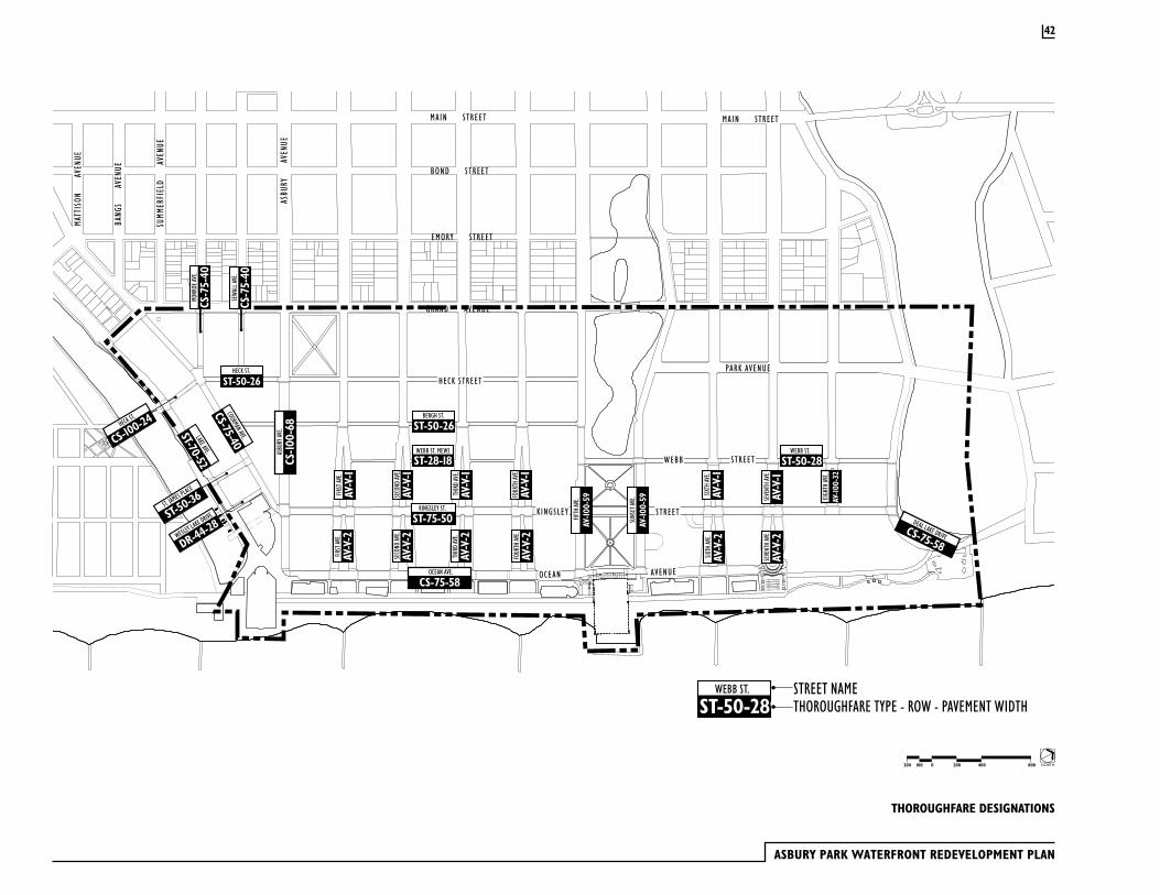
ASBURY PARK WATERFRONT REDEVELOPMENT PLAN
42
WEBB ST.
ST-50-289STREET NAMETHOROUGHFARE TYPE - ROW - PAVEMENT WIDTH
WEBB ST. MEWS
ST-28-18WEBB ST.
ST-50-28
SECO
ND AV
E.
AV-V-2
THIR
D AV
E.
AV-V-2
FOUR
TH AV
E.
AV-V-2
FIRST
AVE.
AV-V-2
FIRST
AVE.
AV-V-1
SECO
ND AV
E.
AV-V-1
THIR
D AV
E.
AV-V-1
FOUR
TH AV
E.
AV-V-1
SIXTH
AVE.
AV-V-2
SIXTH
AVE.
AV-V-1
SEVE
NTH
AVE.
AV-V-2
SEVE
NTH
AVE.
AV-V-1
EIGH
TH AV
E.
AV-100-32
BERGH ST.
ST-50-26
HECK ST.
ST-50-26
SEW
ALL A
VE.
CS-75-40
MONR
OE AV
E.
CS-75-40
KINGSLEY ST.
ST-75-50
OCEAN AVE.
CS-75-58
ASBU
RY AV
E.
CS-100-68
FIFTH
AVE.
AV-100-59
SUNS
ET AV
E.
WESLEY LAKE DRIVE
DR-44-28
COOKMAN AVE.
CS-75-40
LAKE AVE.
ST-70-52
ST. JAMES PLACE
ST-50-36
HECK ST.
CS-100-24
DEAL LAKE DRIVECS-75-58
AV-100-59
GRAND AVENUE
SUMM
ERFI
ELD
A
VENU
E
ASBU
RY
AV
ENUE
EMORY STREET
BOND STREET
MAIN STREET
NEW YORK & LONG BRANCH RAILROAD CO.
MAIN STREETBA
NGS
A
VENU
E
MATT
ISON
AVEN
UE
PARK AVENUEHECK STREET
KINGSLEY STREET
OCEAN AVENUE
WEBB STREET
NORTH2000100200 400 800
THOROUGHFARE DESIGNATIONS
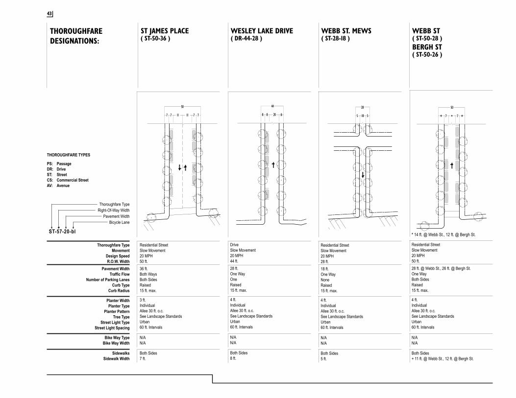
THOROUGHFARE TYPES
PS: PassageDR: DriveST: StreetCS: Commercial StreetAV: Avenue
Thoroughfare TypeMovement
Design SpeedR.O.W. Width
Pavement WidthTraffic Flow
Number of Parking LanesCurb Type
Curb Radius
Planter WidthPlanter Type
Planter PatternTree Type
Street Light TypeStreet Light Spacing
Bike Way TypeBike Way Width
SidewalksSidewalk Width
Residential StreetSlow Movement20 MPH28 ft.18 ft.One WayNoneRaised15 ft. max.
4 ft.IndividualAllee 30 ft. o.c.See Landscape StandardsUrban60 ft. Intervals
Thoroughfare TypeRight-Of-Way Width
Pavement WidthBicycle Lane
ST-57-20-bl
N/AN/A
Both Sides5 ft.
Residential StreetSlow Movement20 MPH50 ft.36 ft.Both WaysBoth SidesRaised15 ft. max.
3 ft.IndividualAllee 30 ft. o.c.See Landscape StandardsUrban60 ft. Intervals
N/AN/A
Both Sides7 ft.
DriveSlow Movement20 MPH44 ft.28 ft.One WayOneRaised15 ft. max.
4 ft.IndividualAllee 30 ft. o.c.See Landscape StandardsUrban60 ft. Intervals
N/AN/A
Both Sides8 ft.
( ST-50-36 )ST JAMES PLACE
( DR-44-28 )WESLEY LAKE DRIVE
( ST-28-18 )WEBB ST. MEWS
Residential StreetSlow Movement20 MPH50 ft.28 ft. @ Webb St., 26 ft. @ Bergh St.One WayBoth SidesRaised15 ft. max.
4 ft.IndividualAllee 30 ft. o.c.See Landscape StandardsUrban60 ft. Intervals
N/AN/A
Both Sides+ 11 ft. @ Webb St., 12 ft. @ Bergh St.
( ST-50-28 )WEBB ST
8 8 20 8
44
185 5
28
7 7 ++ *
50
7 7 711 11 7
50
THOROUGHFAREDESIGNATIONS:
* 14 ft. @ Webb St., 12 ft. @ Bergh St.
( ST-50-26 )BERGH ST
43
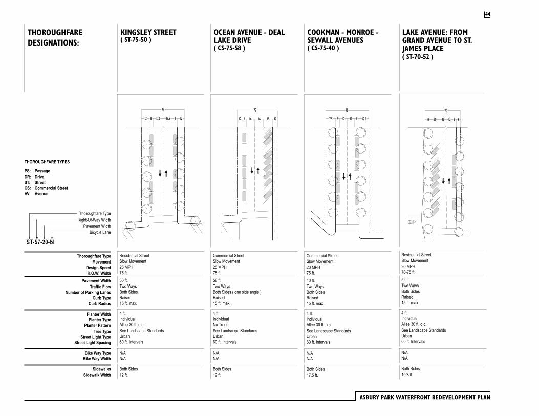
ASBURY PARK WATERFRONT REDEVELOPMENT PLAN
Thoroughfare TypeMovement
Design SpeedR.O.W. Width
Pavement WidthTraffic Flow
Number of Parking LanesCurb Type
Curb Radius
Planter WidthPlanter Type
Planter PatternTree Type
Street Light TypeStreet Light Spacing
Bike Way TypeBike Way Width
SidewalksSidewalk Width
Thoroughfare TypeRight-Of-Way Width
Pavement WidthBicycle Lane
ST-57-20-bl
( ST-75-50 )( CS-75-58 ) ( CS-75-40 )
Residential StreetSlow Movement25 MPH75 ft.50 ft.Two WaysBoth SidesRaised15 ft. max.
4 ft.IndividualAllee 30 ft. o.c.See Landscape StandardsUrban60 ft. Intervals
N/AN/A
Both Sides12 ft.
Commercial StreetSlow Movement25 MPH75 ft.58 ft.Two WaysBoth Sides ( one side angle )Raised15 ft. max.
4 ft.IndividualNo TreesSee Landscape StandardsUrban60 ft. Intervals
N/AN/A
Both Sides12 ft.
Commercial StreetSlow Movement20 MPH75 ft.40 ft.Two WaysBoth SidesRaised15 ft. max.
4 ft.IndividualAllee 30 ft. o.c.See Landscape StandardsUrban60 ft. Intervals
N/AN/A
Both Sides17.5 ft.
KINGSLEY STREET OCEAN AVENUE - DEAL LAKE DRIVE
COOKMAN - MONROE - SEWALL AVENUES
( ST-70-52 )
Residential StreetSlow Movement20 MPH70-75 ft.52 ft.Two WaysBoth SidesRaised15 ft. max.
4 ft.IndividualAllee 30 ft. o.c.See Landscape StandardsUrban60 ft. Intervals
N/AN/A
Both Sides10/8 ft.
LAKE AVENUE: FROM GRAND AVENUE TO ST. JAMES PLACE
12 8 817.5 17.5 12
75
16 16812 1218
75
17.5 8 12 8 17.5
75
12 20 812 12 810
70
THOROUGHFARE TYPES
PS: PassageDR: DriveST: StreetCS: Commercial StreetAV: Avenue
THOROUGHFAREDESIGNATIONS:
44
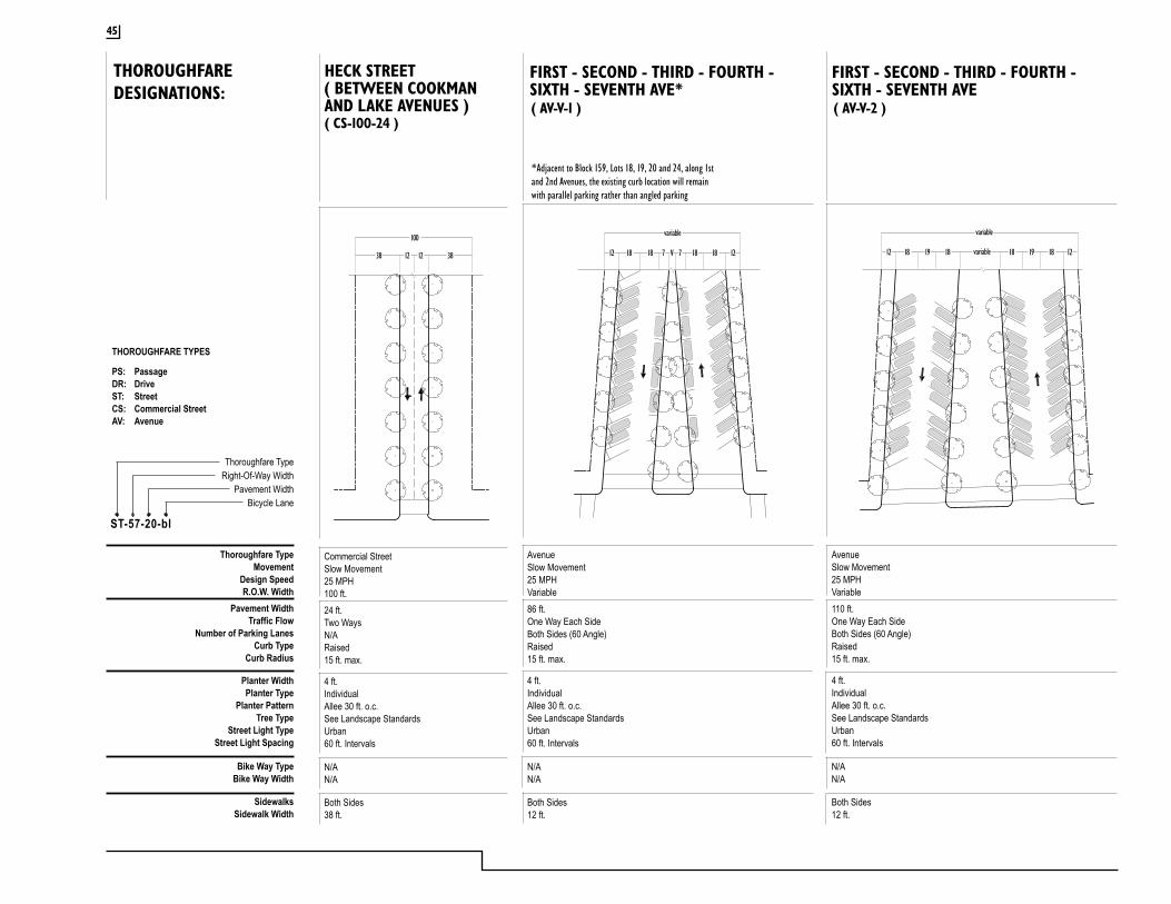
( AV-V-1 )
*Adjacent to Block 159, Lots 18, 19, 20 and 24, along 1st and 2nd Avenues, the existing curb location will remain with parallel parking rather than angled parking
AvenueSlow Movement25 MPHVariable86 ft.One Way Each SideBoth Sides (60 Angle)Raised15 ft. max.
4 ft.IndividualAllee 30 ft. o.c.See Landscape StandardsUrban60 ft. Intervals
N/AN/A
Both Sides12 ft.
FIRST - SECOND - THIRD - FOURTH - SIXTH - SEVENTH AVE*
AvenueSlow Movement25 MPHVariable110 ft.One Way Each SideBoth Sides (60 Angle)Raised15 ft. max.
4 ft.IndividualAllee 30 ft. o.c.See Landscape StandardsUrban60 ft. Intervals
N/AN/A
Both Sides12 ft.
Thoroughfare TypeMovement
Design SpeedR.O.W. Width
Pavement WidthTraffic Flow
Number of Parking LanesCurb Type
Curb Radius
Planter WidthPlanter Type
Planter PatternTree Type
Street Light TypeStreet Light Spacing
Bike Way TypeBike Way Width
SidewalksSidewalk Width
Thoroughfare TypeRight-Of-Way Width
Pavement WidthBicycle Lane
ST-57-20-bl
FIRST - SECOND - THIRD - FOURTH - SIXTH - SEVENTH AVE( AV-V-2 )
18 18 1877 V 18 1212
variable
18 19 191818 18 1212 variable
variable
THOROUGHFARE TYPES
PS: PassageDR: DriveST: StreetCS: Commercial StreetAV: Avenue
( CS-100-24 )
Commercial StreetSlow Movement25 MPH100 ft.24 ft.Two WaysN/ARaised15 ft. max.
4 ft.IndividualAllee 30 ft. o.c.See Landscape StandardsUrban60 ft. Intervals
N/AN/A
Both Sides38 ft.
HECK STREET( BETWEEN COOKMAN AND LAKE AVENUES )
38 3812
100
12
THOROUGHFAREDESIGNATIONS:
45

ASBURY PARK WATERFRONT REDEVELOPMENT PLAN
( AV-100-59 )
*Adjacent to Block 178, Lots 8 and 9, along 5th Avenue, the existing curb location will remain with parallel parking rather than angled parking
AvenueSlow Movement25 MPH100 ft.59 ft.One Way Each SideBoth Sides (60 Angle Parking )Raised15 ft. max.
4 ft.IndividualAllee 30 ft. o.c.See Landscape StandardsUrban60 ft. Intervals
N/AN/A
Both Sides10/12 ft.
FIFTH - SUNSET AVENUE*( CS-100-68 )
Commercial StreetSlow Movement25 MPH100 ft.68 ft.Two WaysBoth Sides (60 Angle Parking )Raised15 ft. max.
4 ft.IndividualAllee 30 ft. o.c.See Landscape StandardsUrban60 ft. Intervals
N/AN/A
Both Sides16 ft.
ASBURY AVENUE( AV-100-32 )
Residential StreetSlow Movement25 MPH100 ft.64 ft.One Way Each SideBoth Sides (60 Angle Parking )Raised15 ft. max.
4 ft.IndividualAllee 30 ft. o.c.See Landscape StandardsUrban60 ft. Intervals
N/AN/A
Both Sides10 ft.
EIGHTH AVENUE
Thoroughfare TypeMovement
Design SpeedR.O.W. Width
Pavement WidthTraffic Flow
Number of Parking LanesCurb Type
Curb Radius
Planter WidthPlanter Type
Planter PatternTree Type
Street Light TypeStreet Light Spacing
Bike Way TypeBike Way Width
SidewalksSidewalk Width
Thoroughfare TypeRight-Of-Way Width
Pavement WidthBicycle Lane
ST-57-20-bl
16 1618 1816
100
1620 20 12 1919
100
10 10 18 1814 14 10
100
16
THOROUGHFARE TYPES
PS: PassageDR: DriveST: StreetCS: Commercial StreetAV: Avenue
THOROUGHFAREDESIGNATIONS:
( ST-70-44 )
Residential StreetSlow Movement20 MPH70-75 ft.44 ft.One WayBoth SidesRaised15 ft. max.
4 ft.IndividualAllee 30 ft. o.c.See Landscape StandardsUrban60 ft. Intervals
N/AN/A
Both Sides14/12 ft.
LAKE AVENUE: FROM ST. JAMES PLACE TO WESLEY LAKE DRIVE
8 2016 1214
70
46
CAFRA & RSIS RequirementsThe issue of parking has been an item of discussion ever since the City of Asbury Park and the master developer initiated discussions with the NJ Department of Environmental Protection concerning the redevelopment of Asbury Park. As noted in the traffic rule of the Coastal Area Facilities Review Act (CAFRA; NJSA 13:19-1 et seq) for ocean front residential development, applicants are required to provide two on-site parking spaces per dwelling unit and in general on-street parking spaces along public roads cannot be credited as part of off-site parking provided for a project.
The City of Asbury Park has noted that the construction of two spaces per dwelling unit within the confines of the blocks of the redevelopment area is not feasible and instead proposed to the NJ Department of Environmental Protection that on-site construction of 1.5 spaces per dwelling unit with the remainder of 0.5 spaces to be made up by on-street parking would be sufficient. The City of Asbury Park has consistently argued that:
1. There are a large number of existing on-street parking spaces throughout the City;
2. There is a substantial amount of existing public mass transit service in Asbury Park including 5 bus routes along Kingsley Avenue;
3. There are future plans for a jitney service to run along Ocean Avenue and connect to the New Jersey Transit station located on Main Street by City Hall; and
4. The overall plan is set up to encourage the use of mass transit into the City with quick service from the train station to the beach by the jitney service.
Because of the availability of mass transit within the City, the applicant felt that the dependence on private auto for commuting and some shopping trips would be diminished as a number of visitors will visit the City utilizing mass transit service thereby not requiring 2 parking spaces per dwelling unit. In addition, the applicant contends that because of this urban setting, people will not be as dependent on cars for most of their convenient shopping, restaurant and recreation trips.
Overall there are 3,164 dwelling units anticipated for construction under the redevelopment plan. This will result in the provision of 4,746 spaces within structured parking directly associated with the new residential developments. In addition to the 1.5 spaces for structured parking to be contained within the residential development, this off-street parking will be supplemented by the construction of a 200 or more space facility behind the Empress Hotel. A surface parking lot of 113 spaces on Block 221 will be constructed. This surface parking lot is associated with the re-establishment of the dune and fishing area at the northern portion of the City.
As detailed in the CAFRA traffic rule, in general, on-street parking along public roads cannot be credited as part of off-site parking provided for the project. The rule was established as a result of the continued popularity if having a “beach experience” in New Jersey and to not preclude day trippers from being able to find a place to park.
The redevelopment of Asbury Park has raised a number of questions of which parking has played a major role. The NJDEP has found that with the exception of development on Blocks 222 and 219, the parking of 1.5 cars per unit in structured spaces with the remainder of each site’s parking requirements satisfied by street parking will meet the intent of this rule and the project is in compliance with the traffic rule.
3.5 Parking in the Prime Renewal Area
47
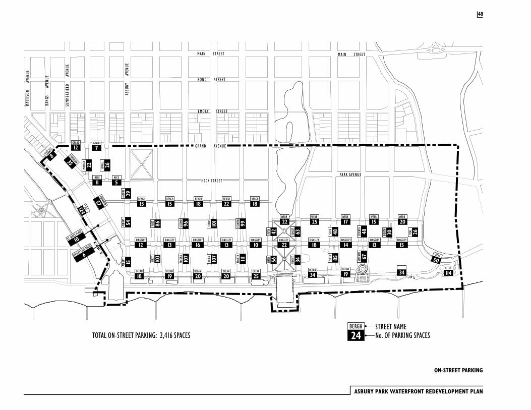
ASBURY PARK WATERFRONT REDEVELOPMENT PLAN
ON-STREET PARKING
BERGH
15
KINGSLEY
12
ASBU
RY
15AS
BURY
54AS
BURY
29
ST. JAMES PLACE
10
FIRST
103
FIRST 86 SE
COND
96 FOUR
TH
99FO
URTH
111 SEVE
NTH
67SE
VENT
H
48FIFTH 42
FIFTH 56 SU
NSET
34SU
NSET
63
SIXTH 85
SIXTH 48 EI
GHTH
30
SECO
ND
107
THIR
D
101
THIR
D
107
KINGSLEY
13
MONR
OE
22 SEW
ALL
26
COOKMAN
57
LAKE124
COOKMAN35
KINGSLEY
16KINGSLEY
13KINGSLEY
10KINGSLEY
18
OCEAN
19OCEAN
34OCEAN
25OCEAN
20OCEAN
20OCEAN
19
KINGSLEY
14KINGSLEY
13KINGSLEY
15
HECK
5HECK
11
BERGH
15BERGH
18BERGH
22BERGH
18
WEBB
25WEBB
17WEBB
15WEBB
20
DEAL 26
DEAL50
OCEAN
18
WESLEY LAKE DRIVE
6
BERGH
24STREET NAMENo. OF PARKING SPACES
KINGSLEY
22
WEBB
22
TOTAL ON-STREET PARKING: 2,416 SPACES
N. LOT
114
GRAND
12GRAND
7
34
GRAND
8
GRAND AVENUE
SUMM
ERFI
ELD
A
VENU
E
ASBU
RY
AV
ENUE
EMORY STREET
BOND STREET
MAIN STREET
NEW YORK & LONG BRANCH RAILROAD CO.
MAIN STREET
BANG
S
AVE
NUE
MATT
ISON
AVEN
UE
PARK AVENUEHECK STREET
48
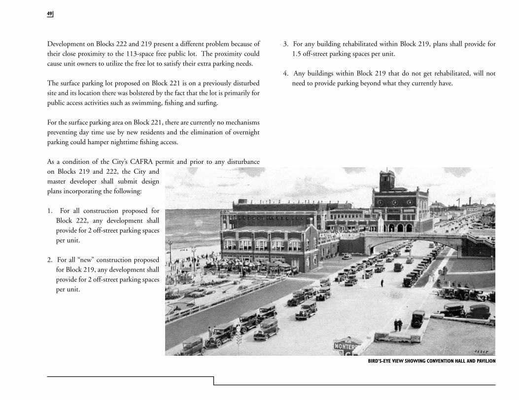
Development on Blocks 222 and 219 present a different problem because of their close proximity to the 113-space free public lot. The proximity could cause unit owners to utilize the free lot to satisfy their extra parking needs.
The surface parking lot proposed on Block 221 is on a previously disturbed site and its location there was bolstered by the fact that the lot is primarily for public access activities such as swimming, fishing and surfing.
For the surface parking area on Block 221, there are currently no mechanisms preventing day time use by new residents and the elimination of overnight parking could hamper nighttime fishing access.
As a condition of the City’s CAFRA permit and prior to any disturbance on Blocks 219 and 222, the City and master developer shall submit design plans incorporating the following:
1. For all construction proposed for Block 222, any development shall provide for 2 off-street parking spaces per unit.
2. For all “new” construction proposed for Block 219, any development shall provide for 2 off-street parking spaces per unit.
3. For any building rehabilitated within Block 219, plans shall provide for 1.5 off-street parking spaces per unit.
4. Any buildings within Block 219 that do not get rehabilitated, will not need to provide parking beyond what they currently have.
BIRD’S-EYE VIEW SHOWING CONVENTION HALL AND PAVILION
49
ASBURY PARK WATERFRONT REDEVELOPMENT PLAN
Commercial Uses
· Hotel, motel, rooming house 1 parking space per or equivalent employee per shift plus 0.75 parking spaces per sleeping unit. Where number of employees cannot be determined, 1 parking space per sleeping unit
The following commercial uses are not required to provide off-street parking:
· Auditoriums, stadiums, theaters, arenas and places of assembly
· Exhibition Pavilions
· General office, banks, research/laboratory
· Physicians, dentists, chiropractors
· Restaurant, nightclub bar
· Retail (including take-out food estab. services)
· Theme Entertainment
Parking RequirementsAs illustrated on the On-Street Parking map, there will be approximately 2,416 on-street parking spaces in the Prime Renewal Area. This amount of on-street parking is more than adequate to support all the retail, restaurant and entertainment uses planned for the area plus provide a substantial amount of parking for residential uses. The off-street parking ratios required in this plan take into consideration the on-street parking facilities and the access to mass transit.
All new development within the Prime Renewal Area shall provide off-street parking as listed below:
Residential Use Parking Requirement
All types of housing units 1.5 Parking spaces
Except as noted below:1. For all construction proposed for Block 222, any development shall
provide for 2 off-street parking spaces per unit.
2. For all “new” construction proposed for Block 219, any development shall provide for 2 off-street parking spaces per unit.
3. For any building rehabilitated within Block 219, plans shall provide for 1.5 off-street parking spaces per unit.
4. Any buildings with Block 219 that do not get rehabilitated will not need to provide parking beyond what they currently have.
50
Nonconforming Parking: Structures and uses within the redevelopment area without adequate parking and loading areas required in this Section and that predate the effective date of this Ordinance, may be continued. Should such structure be increased in area or changed in use, the parking and loading required shall be determined by applying the standards set forth herein to the entire structure or use.
Parking On Vacant Lots: No vacant lot shall be used for parking of one (1) or more vehicles of any kind unless it shall be property graded, paved, lighted and fenced or screened according to specifications established for this purpose.
Parking stalls for full-size vehicles shall be provide in accordance with the following:
· The minimum dimensions for each parking stall shall be nine (9) feet in width and eighteen (18) feet in length.
· Not more than thirty-five (35) percent of the parking spaces required by these regulations shall be for compact vehicles.
Parking Lot Buffers: All parking lots of five (5) or more spaces shall conform to buffering and planting standards contained under “Landscape Architecture.”
51
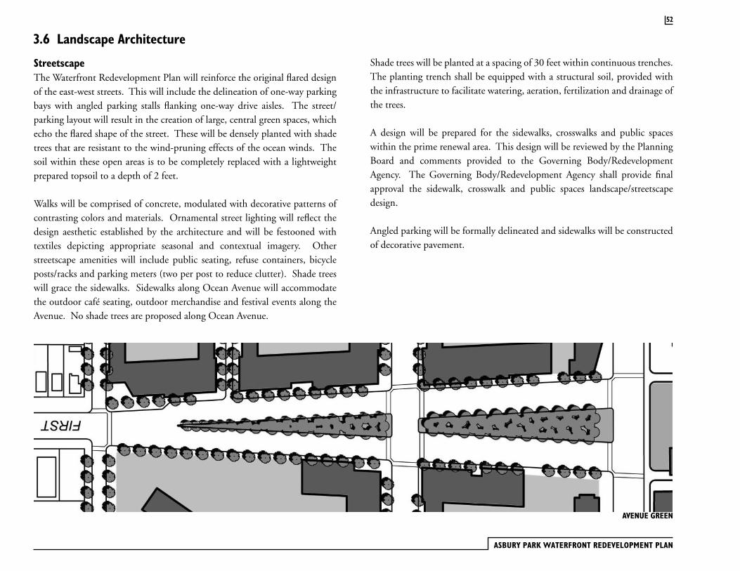
ASBURY PARK WATERFRONT REDEVELOPMENT PLAN
52
StreetscapeThe Waterfront Redevelopment Plan will reinforce the original flared design of the east-west streets. This will include the delineation of one-way parking bays with angled parking stalls flanking one-way drive aisles. The street/parking layout will result in the creation of large, central green spaces, which echo the flared shape of the street. These will be densely planted with shade trees that are resistant to the wind-pruning effects of the ocean winds. The soil within these open areas is to be completely replaced with a lightweight prepared topsoil to a depth of 2 feet.
Walks will be comprised of concrete, modulated with decorative patterns of contrasting colors and materials. Ornamental street lighting will reflect the design aesthetic established by the architecture and will be festooned with textiles depicting appropriate seasonal and contextual imagery. Other streetscape amenities will include public seating, refuse containers, bicycle posts/racks and parking meters (two per post to reduce clutter). Shade trees will grace the sidewalks. Sidewalks along Ocean Avenue will accommodate the outdoor café seating, outdoor merchandise and festival events along the Avenue. No shade trees are proposed along Ocean Avenue.
Shade trees will be planted at a spacing of 30 feet within continuous trenches. The planting trench shall be equipped with a structural soil, provided with the infrastructure to facilitate watering, aeration, fertilization and drainage of the trees.
A design will be prepared for the sidewalks, crosswalks and public spaces within the prime renewal area. This design will be reviewed by the Planning Board and comments provided to the Governing Body/Redevelopment Agency. The Governing Body/Redevelopment Agency shall provide final approval the sidewalk, crosswalk and public spaces landscape/streetscape design.
Angled parking will be formally delineated and sidewalks will be constructed of decorative pavement.
3.6 Landscape Architecture
AVENUE GREEN
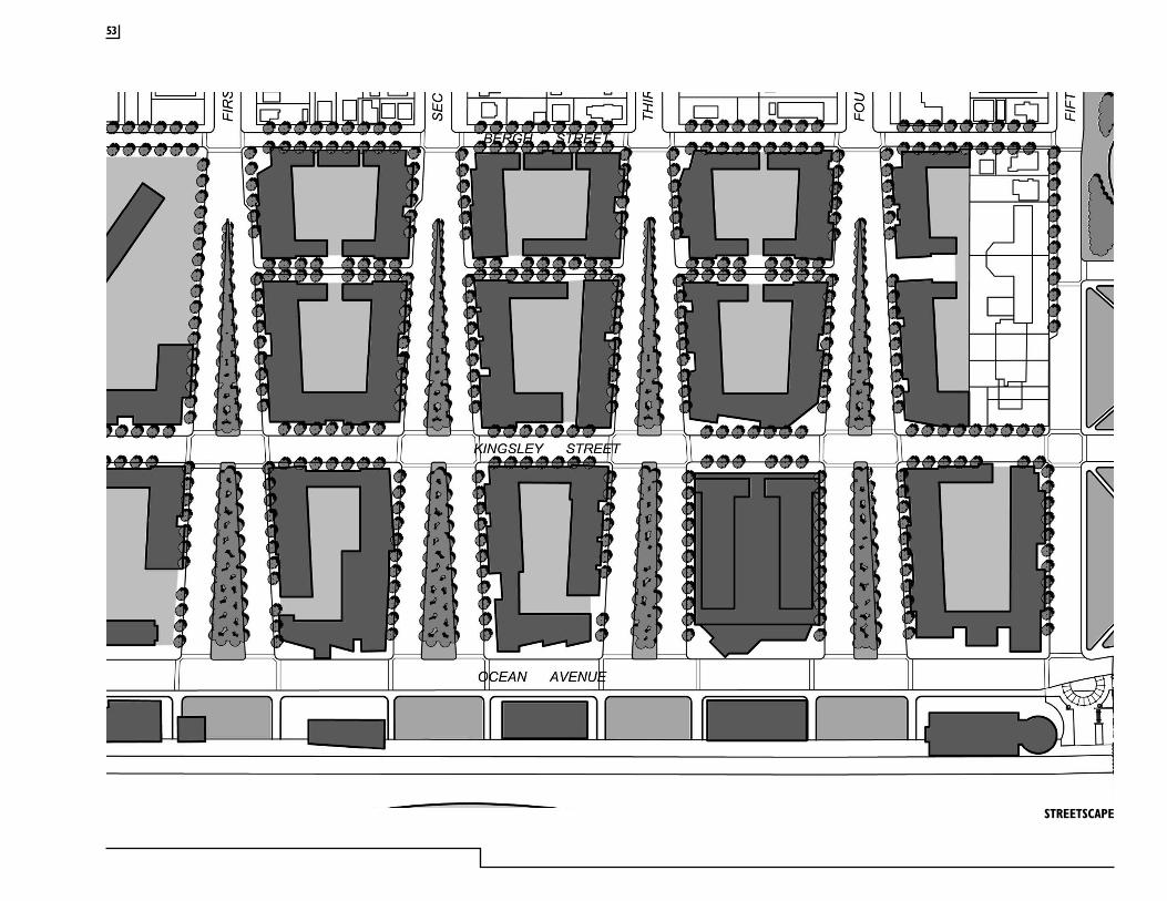
STREETSCAPE
53
ASBURY PARK WATERFRONT REDEVELOPMENT PLAN
54
Urban ForestryThe public spaces in Asbury Park’s Waterfront Redevelopment Area (WRA) are an integral component of the public infrastructure upon which the private redevelopment efforts will be based. It is, therefore, critical that the design of these public landscapes occurs at a level that complements the high standards that are set for the architecture within the WRA. This section of the Waterfront Redevelopment Plan (WRP) prescribes the minimum level of landscape architectural improvements that will be installed within designated public thoroughfares and public spaces.
Plant Culture of Asbury Park’s Seashore EnvironmentThe oceanfront represents a significant challenge to the successful use and maintenance of plant species. Naturally occurring plants within this environment include species that can survive on very little soil moisture and that are tolerant of the caustic effects of salt spray. Typical oceanfront dune environments in coastal New Jersey support American beachgrass, Virginia creeper and seaside goldenrod, among other scrub and herbaceous plants. In areas where a natural series of dunes have been permitted to remain, larger species, including American holly, black cherry and hackberry, occupy the dune woodland located in the most upland position. Unfortunately, most of these species are not appropriate to design applications within typical urban spaces.
The influence of the Atlantic Ocean places significant limitations upon the range of plant species that may be used within the Waterfront Redevelopment Area. Nevertheless, successful design of urban streets and thoroughfares places heavy reliance upon the integration of trees to provide shade, comfort, greenery and visual relief from the extent of built surfaces. Very few species of trees that are acceptable for use as street shade trees are also tolerant of the oceanfront environment. Of those species that can survive, the effects of wind pruning and salt spray – the stunting of the growth of plant tissue in response to severe northeast winds and windblown salt from the ocean- result in distinctive changes in plant morphology.
In examining the existing range of trees within the WRA, very few are found. Street trees begin to exert a presence in the second block from the ocean. Along Cookman Avenue numerous street trees appear to be thriving. Shade trees around Sunset Lake exhibit slight effects of wind/salt pruning. Some isolated trees are found closer to the Boardwalk. In the areas where the blocks have been demolished and cleared, no trees exist. Along Wesley Lake several species are doing well, but have been shaped by the ocean winds and salt spray.
A clear correlation between the proximity and height of buildings and the extent to which trees have been influenced by wind and salt spray is exhibited within the WRA. Where trees are nestled between buildings, the trees have risen to the match the height of the buildings before submitting to the influence of the ocean winds. In the first block from the Boardwalk, where most of the buildings have been razed, virtually no trees exist. In the open spaces near the lakes, ocean winds are able to infiltrate the city grid a bit further than in the building blocks. This provides evidence of the success of Bradley’s original plan, which sought to introduce ocean breezes into the heart of Asbury Park through the creation of flared streets and public open spaces.
In response to this acute environmental influence, plant selections within WRA are somewhat limited. In spite of these limitations, the goal of the WRP is to introduce street trees on nearly every thoroughfare in the WRA. Since street tree species tolerant of oceanfront conditions are limited, a narrow range of species is included. Although this may result in a public streetscape that lacks diversity, on balance the selected trees will have a higher probability of surviving and, therefore, contribute to the rejuvenated character of the city. It is also acknowledged that the trees that are planted within the WRA will be shaped by the ocean winds that will continue to influence the environment of Asbury Park. This will be manifested in tree heights that are significantly lower than those that would normally be attained in a non-coastal environment. In addition to lower tree heights, tree morphology will exhibit a stunted or asymmetrical appearance where ocean winds come in contact with twigs. This will impart a unique, picturesque character upon the public landscapes within the WRA. Although

the wind pruning effects cannot be totally eliminated, it is anticipated that the construction of new buildings within the WRA, with heights ranging from two to eight stories, will create buffers that will shield trees and permit fuller plant development, relatively unhindered by the effects of the ocean breezes below the cornice line. This will permit a wider range of plant material to be used in the areas that are not directly adjacent to the Boardwalk. In areas where the influence of the ocean cannot be buffered, no street/shade trees will be planted.
Urban SoilsAnother threat to the survival and development of plant material in the Waterfront Redevelopment Area (WRA) is urban soil. The soils of the WRA are low in fertility with low available soil moisture, low levels of organic matter and a high degree of compaction. These factors alone are capable of killing trees. These factors combined with the salt spray and desiccating winds of the Atlantic Ocean will certainly result in the demise of newly planted trees. Public plantings, including all street/thoroughfare trees, ornamental trees, shrubs and lawns, will be placed in suitably sized planting areas containing a prepared mixture of planting medium. No original soil from the WRA is permitted to be placed within planting beds. All plantings, including those within sidewalks will be outfitted with the infrastructure to facilitate irrigation, fertilization, aeration and drainage. This commitment to the proper installation of plants and their ongoing maintenance will add value to the private lands that abut public spaces within the WRA.
Planting Standards
SoilsSidewalk Plantings: Street tree plantings within sidewalk areas and mews shall be placed in continuous-trenches that have a minimum depth of two (2) feet. A prepared planting medium shall be utilized that is capable of permitting the percolation of water and air, while also supporting the sidewalk above. Admixtures, such as expanded slate, shall be used to achieve this performance. Non-Sidewalk Plantings: Plantings within park spaces and median shall be placed in prepared planting medium with a minimum depth of two (2) feet.
Soil Volume: Trees shall have a minimum soil volume of 625 CF Shrubs shall have a minimum soil volume of 40 CF
Park Areas: Bradley Park, Wesley Lake Park and the park areas in each of the numbered avenues shall have a prepared planting medium installed to a minimum depth of two (2) feet over the entire unpaved area.
Texture: Prepared planting media shall be a LOAM, according to the USDA texture classification system
PH: All planting media shall have a pH between 6 and 6.5
Dune Areas: The dune areas of the north shore shall be comprised of clean sand scraped from areas of the beach that are capable of contributing sand without compromising the integrity of the existing beach. If local sources of sand are inadequate, then additional sand shall be imported to match the texture of the existing beach sand. The dune height shall range from six to eight feet in height. The dune sand is not subject to the same textural and pH standards as the other planting media.
Irrigation, Aeration and Drainage
All plantings shall be irrigated. Sidewalk Plantings: Sidewalk tree plantings shall be irrigated and aerated via access ports that are located within the planting trench and the sidewalk. Water access utilities shall be provided at street ends to facilitate hand irrigation and fertilization through the access ports.
Park Area Plantings: All park area plantings and turf areas shall be irrigated with automated irrigation systems. A combination of drip and throw irrigation should be used to promote water conservation.
55
ASBURY PARK WATERFRONT REDEVELOPMENT PLAN
56
Plant MaterialQuality and Size: All plants shall be nursery grown, habit of growth that is normal for the species, sound, healthy, vigorous and free from insects, diseases, and injuries. Equal to or exceed measurements specified in plant list. Plants measured before pruning with branches in normal position; necessary pruning done at time of planting. Sizes and methods of handling shall be according to the code of standards recommended by the AAN and ANSI.
Street/Shade Trees: Street trees shall be a minimum of 3”-3.5” caliper, 13’-15’ in height, minimum 7-foot branching height. Trees within the Avenue Greens shall be 1.5”-2” caliper, 10’-12’ in height
Dune Plantings: Dunes shall be established with plantings of Cape American beachgrass (Ammophila breviligulata) at a spacing of 24” on-center
Trees According to Thoroughfare
Wesley Lake Village PassageWashington hawthorn (Crataegus phaenopyrum)Alternate: Amur maple (Acer ginalla “Flame”)
Wesley Lake Village Drive Patmore green ash (Fraxinus pennsylvanica “Patmore”) Alternate: seedless Kentucky coffeetree (Gymnocladus dioicus “Crosswicks Male”)
Webb MewsGolden raintree (Koelreuteria paniculata)Alternate: littleleaf linden (Tilia cordata “Greenspire”)
Webb – Bergh StreetJapanese zelkova (Zelkova serrata “Green Vase”)Alternate: red maple (Acer rubrum)
Heck Street between Cookman and Lake AvenueJapanese zelkova (Zelkova serrata “Green Vase”)Alternate: red maple (Acer rubrum)
Heck Street between Asbury and Cookman AvenueBloodgood London planetree (Platanus x acerifolia “Bloodgood”) Alternate: sycamore maple (Acer pseudoplatanus)
Kingsley StreetScholartree (Styphnolobium japonica)Alternate: thornless honey locust (Gleditsia triacanthos var. Inermis)
Ocean AvenueNo street trees
Deal Lake DriveSidewalk:Bloodgood London planetree (Platanus x acerifolia “Bloodgood”) Alternate: sycamore maple (Acer pseudoplatanus)
Cookman – Monroe – Sewall AvenueScholartree (Styphnolobium japonica)Alternate: thornless honey locust (Gleditsia triacanthos var. Inermis)
Lake AvenueBloodgood London planetree (Platanus x acerifolia “Bloodgood”) Alternate: sycamore maple (Acer pseudoplatanus)
First –Second-Third-Fourth-Sixth- Seventh AvenuesSidewalk:Bloodgood London planetree (Platanus x acerifolia “Bloodgood”) Alternate: sycamore maple (Acer pseudoplatanus)
Avenue GreenHackberry (Celtis x occidentalis “Magnifica”)Alternate: tupelo (Nyssa sylvatica)
In the avenue green trees will be spaced 20 feet on-center in a staggered grid to encompass the entire park area .
Fifth- Sunset AvenueSidewalk:Bloodgood London planetree (Platanus x acerifolia “Bloodgood”) Alternate: sycamore maple (Acer pseudoplatanus)
Park Area:Hackberry (Celtis x occidentalis “Magnifica”)Alternate: tupelo (Nyssa sylvatica)
Eighth AvenueSidewalk:Bloodgood London planetree (Platanus x acerifolia “Bloodgood”) Alternate: sycamore maple (Acer pseudoplatanus)
Park Area:Hackberry (Celtis x occidentalis “Magnifica”)Alternate: tupelo (Nyssa sylvatica)
Asbury AvenueBloodgood London planetree (Platanus x acerifolia “Bloodgood”) Alternate: sycamore maple (Acer pseudoplatanus)
Other Public Spaces
Bradley ParkBloodgood London planetree (Platanus x acerifolia “Bloodgood”) Alternate: sycamore maple (Acer pseudoplatanus) Hackberry (Celtis x occidentalis “Magnifica”)Alternate: tupelo (Nyssa sylvatica)
North Shore DunesDunes will have no trees; Cape American beachgrass (Ammophila breviligulata) will be planted at 24” on-center to stabilize sand.
Public Spaces Between Ocean Avenue and BoardwalkThese areas will be established in lawn; may be developed with formal seaside garden plantings if not otherwise developed with active recreational activities; no shade trees will be planted
Wesley LakeInformal plantings will be provided along the lake edge to complement the more formal street tree plantings along Lake Avenue.
57
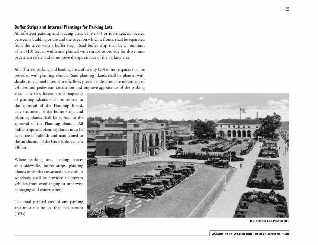
ASBURY PARK WATERFRONT REDEVELOPMENT PLAN
58
Buffer Strips and Internal Plantings for Parking LotsAll off-street parking and loading areas of five (5) or more spaces, located between a building or use and the street on which it fronts, shall be separated from the street with a buffer strip. Said buffer strip shall be a minimum of ten (10) feet in width and planted with shrubs to provide for driver and pedestrian safety and to improve the appearance of the parking area.
All off-street parking and loading areas of twenty (20) or more spaces shall be provided with planting islands. Said planting islands shall be planted with shrubs, to channel internal traffic flow, prevent indiscriminate movement of vehicles, aid pedestrian circulation and improve appearance of the parking area. The size, location and frequency of planting islands shall be subject to the approval of the Planning Board. The treatment of the buffer strips and planting islands shall be subject to the approval of the Planning Board. All buffer strips and planting islands must be kept free of rubbish and maintained to the satisfaction of the Code Enforcement Officer.
Where parking and loading spaces abut sidewalks, buffer strips, planting islands or similar construction, a curb or wheelstop shall be provided to prevent vehicles from overhanging or otherwise damaging said construction.
The total planted area of any parking area must not be less than ten percent (10%).
R.R. STATION AND POST OFFICE
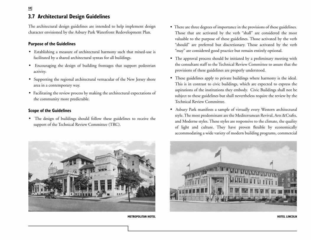
The architectural design guidelines are intended to help implement design character envisioned by the Asbury Park Waterfront Redevelopment Plan.
Purpose of the Guidelines
· Establishing a measure of architectural harmony such that mixed-use is facilitated by a shared architectural syntax for all buildings.
· Encouraging the design of building frontages that support pedestrian activity.
· Supporting the regional architectural vernacular of the New Jersey shore area in a contemporary way.
· Facilitating the review process by making the architectural expectations of the community more predictable.
Scope of the Guidelines
· The design of buildings should follow these guidelines to receive the support of the Technical Review Committee (TRC).
· There are three degrees of importance in the provisions of these guidelines. Those that are activated by the verb “shall” are considered the most valuable to the purpose of these guidelines. Those activated by the verb “should” are preferred but discretionary. Those activated by the verb “may” are considered good practice but remain entirely optional.
· The approval process should be initiated by a preliminary meeting with the consultant staff to the Technical Review Committee to assure that the provisions of these guidelines are properly understood.
· These guidelines apply to private buildings where harmony is the ideal. This is in contrast to civic buildings, which are expected to express the aspirations of the institutions they embody. Civic Buildings shall not be subject to these guidelines but shall nevertheless require the review by the Technical Review Committee.
· Asbury Park manifests a sample of virtually every Western architectural style. The most predominant are the Mediterranean Revival, Arts &Crafts, and Moderne styles. These styles are responsive to the climate, the quality of light and culture. They have proven flexible by economically accommodating a wide variety of modern building programs, commercial
3.7 Architectural Design Guidelines
59
HOTEL LINCOLNMETROPOLITAN HOTEL

ASBURY PARK WATERFRONT REDEVELOPMENT PLAN
as well as residential. These guidelines encourage the expression of these styles in a modern and contemporary way appropriate of new oceanfront architecture.
· The Mediterranean Revival style predominates along the Atlantic Ocean Shore. It involves, in various combination, those elements of masonry construction derived from the architecture of the Mediterranean basin, seen in areas of historic Hispanic settlement, and later influenced by the techniques of wood construction brought by settlers from the Northern states and the Caribbean. Within this range there is sufficient variety for an urbanism that its use, as encouraged in these guidelines, should foster a richness from skilled architects.
· It is implicit in these guidelines that the many recent Neo-eclectic stylistic fashions defining the suburbs in recent years are not welcome, and their use is not encouraged. These free adaptations of various historic details to contemporary forms diminishes the regional architectural qualities so skillfully nurtured by the pioneering architects.
· The intention of these guidelines is to properly execute the Mediterranean Revival, Arts & Crafts, and Moderne styles, which have emerged as the preferred styles of the City of Asbury Park. Other styles with a significant historical development (such as Art Deco-Streamline) may also be appropriate and while not intended to be discouraged, are not addressed in these guidelines. If proposed, the design should strictly adhere to a documented and substantiated stylistic format.
· Architectural design quality of the buildings to be built in the Waterfront Redevelopment Area is of the utmost importance. Developers shall employ architects that have demonstrated their ability to design high quality buildings in an urban setting. A minimum of two design architects shall be used to design each development block, so as to avoid the new constructions from looking like a “project.”
60
NEW MONTEREY HOTEL JEFFERSON HOTEL
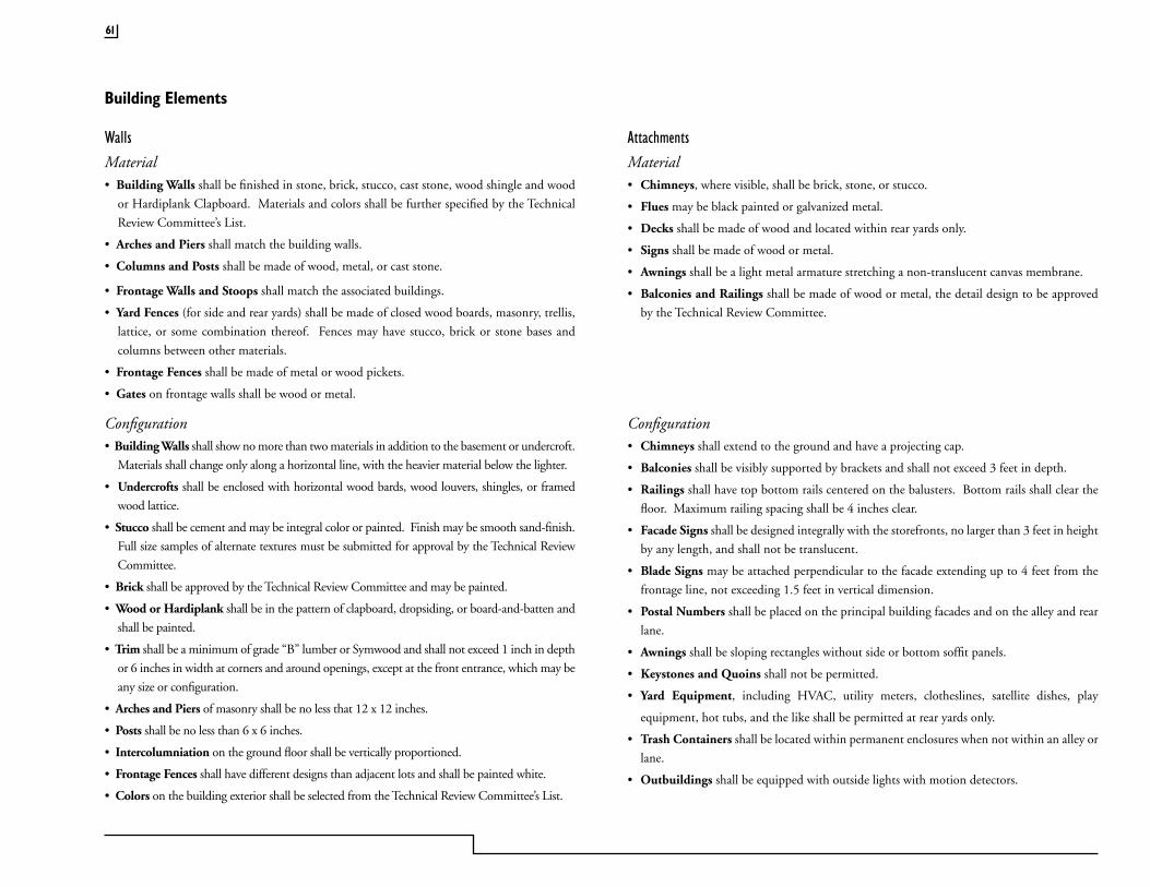
Material• Building Walls shall be finished in stone, brick, stucco, cast stone, wood shingle and wood
or Hardiplank Clapboard. Materials and colors shall be further specified by the Technical
Review Committee’s List.
• Arches and Piers shall match the building walls.
• Columns and Posts shall be made of wood, metal, or cast stone.
• Frontage Walls and Stoops shall match the associated buildings.
• Yard Fences (for side and rear yards) shall be made of closed wood boards, masonry, trellis,
lattice, or some combination thereof. Fences may have stucco, brick or stone bases and
columns between other materials.
• Frontage Fences shall be made of metal or wood pickets.
• Gates on frontage walls shall be wood or metal.
Walls AttachmentsMaterial• Chimneys, where visible, shall be brick, stone, or stucco.
• Flues may be black painted or galvanized metal.
• Decks shall be made of wood and located within rear yards only.
• Signs shall be made of wood or metal.
• Awnings shall be a light metal armature stretching a non-translucent canvas membrane.
• Balconies and Railings shall be made of wood or metal, the detail design to be approved
by the Technical Review Committee.
Configuration• Building Walls shall show no more than two materials in addition to the basement or undercroft.
Materials shall change only along a horizontal line, with the heavier material below the lighter.
• Undercrofts shall be enclosed with horizontal wood bards, wood louvers, shingles, or framed
wood lattice.
• Stucco shall be cement and may be integral color or painted. Finish may be smooth sand-finish.
Full size samples of alternate textures must be submitted for approval by the Technical Review
Committee.
• Brick shall be approved by the Technical Review Committee and may be painted.
• Wood or Hardiplank shall be in the pattern of clapboard, dropsiding, or board-and-batten and
shall be painted.
• Trim shall be a minimum of grade “B” lumber or Symwood and shall not exceed 1 inch in depth
or 6 inches in width at corners and around openings, except at the front entrance, which may be
any size or configuration.
• Arches and Piers of masonry shall be no less that 12 x 12 inches.
• Posts shall be no less than 6 x 6 inches.
• Intercolumniation on the ground floor shall be vertically proportioned.
• Frontage Fences shall have different designs than adjacent lots and shall be painted white.
• Colors on the building exterior shall be selected from the Technical Review Committee’s List.
Configuration• Chimneys shall extend to the ground and have a projecting cap.
• Balconies shall be visibly supported by brackets and shall not exceed 3 feet in depth.
• Railings shall have top bottom rails centered on the balusters. Bottom rails shall clear the
floor. Maximum railing spacing shall be 4 inches clear.
• Facade Signs shall be designed integrally with the storefronts, no larger than 3 feet in height
by any length, and shall not be translucent.
• Blade Signs may be attached perpendicular to the facade extending up to 4 feet from the
frontage line, not exceeding 1.5 feet in vertical dimension.
• Postal Numbers shall be placed on the principal building facades and on the alley and rear
lane.
• Awnings shall be sloping rectangles without side or bottom soffit panels.
• Keystones and Quoins shall not be permitted.
• Yard Equipment, including HVAC, utility meters, clotheslines, satellite dishes, play
equipment, hot tubs, and the like shall be permitted at rear yards only.
• Trash Containers shall be located within permanent enclosures when not within an alley or
lane.
• Outbuildings shall be equipped with outside lights with motion detectors.
Building Elements
61
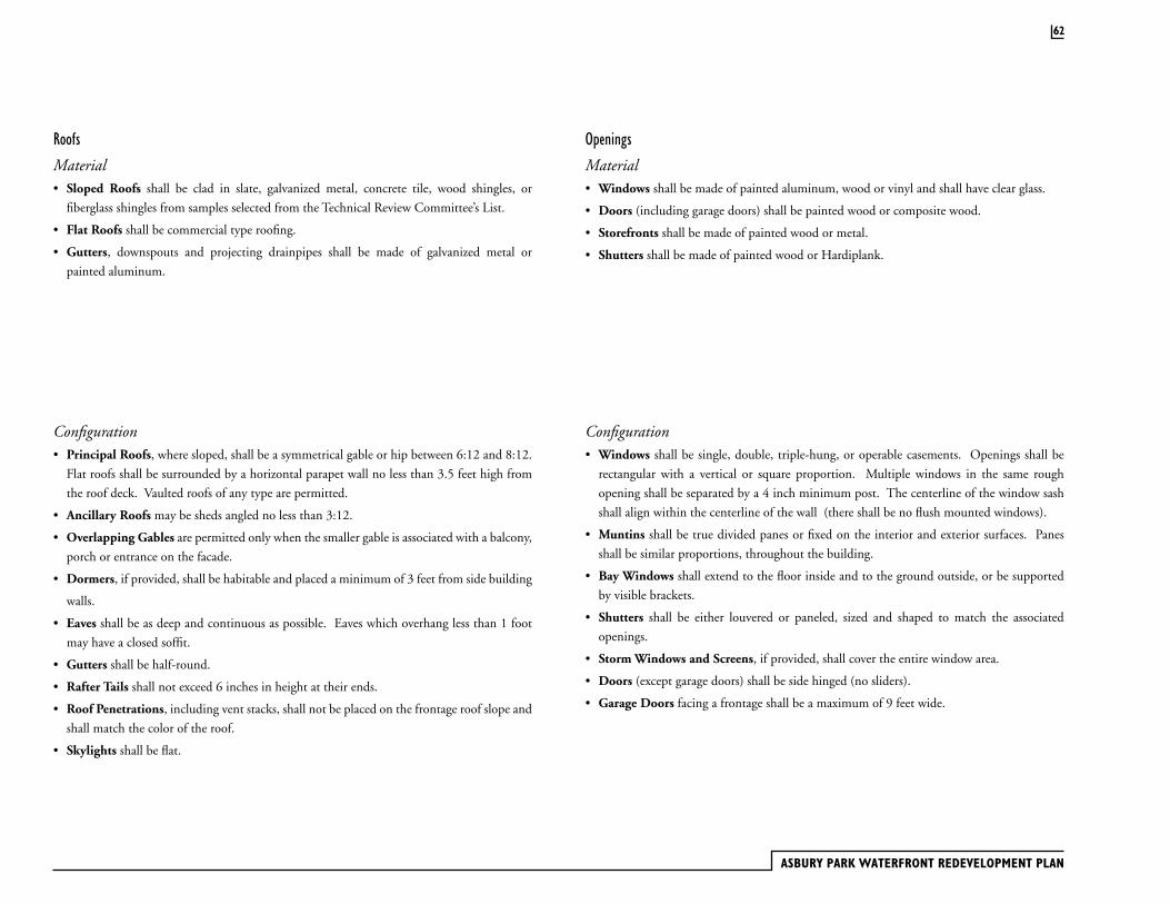
ASBURY PARK WATERFRONT REDEVELOPMENT PLAN
Roofs Openings
Material• Sloped Roofs shall be clad in slate, galvanized metal, concrete tile, wood shingles, or
fiberglass shingles from samples selected from the Technical Review Committee’s List.
• Flat Roofs shall be commercial type roofing.
• Gutters, downspouts and projecting drainpipes shall be made of galvanized metal or
painted aluminum.
Material• Windows shall be made of painted aluminum, wood or vinyl and shall have clear glass.
• Doors (including garage doors) shall be painted wood or composite wood.
• Storefronts shall be made of painted wood or metal.
• Shutters shall be made of painted wood or Hardiplank.
Configuration• Principal Roofs, where sloped, shall be a symmetrical gable or hip between 6:12 and 8:12.
Flat roofs shall be surrounded by a horizontal parapet wall no less than 3.5 feet high from
the roof deck. Vaulted roofs of any type are permitted.
• Ancillary Roofs may be sheds angled no less than 3:12.
• Overlapping Gables are permitted only when the smaller gable is associated with a balcony,
porch or entrance on the facade.
• Dormers, if provided, shall be habitable and placed a minimum of 3 feet from side building
walls.
• Eaves shall be as deep and continuous as possible. Eaves which overhang less than 1 foot
may have a closed soffit.
• Gutters shall be half-round.
• Rafter Tails shall not exceed 6 inches in height at their ends.
• Roof Penetrations, including vent stacks, shall not be placed on the frontage roof slope and
shall match the color of the roof.
• Skylights shall be flat.
Configuration• Windows shall be single, double, triple-hung, or operable casements. Openings shall be
rectangular with a vertical or square proportion. Multiple windows in the same rough
opening shall be separated by a 4 inch minimum post. The centerline of the window sash
shall align within the centerline of the wall (there shall be no flush mounted windows).
• Muntins shall be true divided panes or fixed on the interior and exterior surfaces. Panes
shall be similar proportions, throughout the building.
• Bay Windows shall extend to the floor inside and to the ground outside, or be supported
by visible brackets.
• Shutters shall be either louvered or paneled, sized and shaped to match the associated
openings.
• Storm Windows and Screens, if provided, shall cover the entire window area.
• Doors (except garage doors) shall be side hinged (no sliders).
• Garage Doors facing a frontage shall be a maximum of 9 feet wide.
62

3. The frontages of new buildings shall be harmonious with the block face on both sides of its street. The existing buildings will provide the design context unless they are non-conforming or non-contributing. Applicants are expected to provide drawn and/or photo documentation of the block faces with the frontage proposed building drawn within its urban context.
4. The base is comprised of the first to third stories of the frontage of a building. It is this portion that has the greatest effect on pedestrian activity. The design of the base, as well as the quality and durability of its materials, should be emphasized. The building’s base should be presented to the PB/SAR at a larger scale of drawing and greater detail than the remainder of the facade.
5. In addition to a base, an urban building includes a middle section and a cap. The middle of the building shall be differentiated from the base by a transition line at the top of the first, second or third floor. The transition line’s specific location is determined primarily by the overall height of the building and that of the adjacent buildings. If adjacent buildings are lower than the proposed building, and judged likely to be permanent, then an effort should be made to have the transition line relate to them.
6. Base frontages are, in descending order of their positive pedestrian contribution; (a) a gallery or arcade; (b) a shopfront with awning; (c) a residential stoop; (d) a fence and porch; (e) a landscaped front yard; (f ) a blank wall; (g) an unbuffered parking structure; and (h) an open parking lot. The latter three types shall be avoided. The allocation and expense of building should reflect this hierarchy.
7. In the absence of a context, the base transition line should be judged to be between one-fifth to one-quarter of the overall height. An additional upper-transition line, articulating the cap, should be placed approximately one-eighth of the overall height from the top. Expression lines may consist of a continuous, shallow balcony; a short setback; or a slightly articulated trim course. The transition should be supported by a change of window rhythm or size and a change in material or color.
8. The roof of a building may be flat, pitched, or both. The rooftop must be
Building Articulation
1. The size of a building is independent of its scale. The scale can be modified by articulation. The articulation should integrate the building scale into the oceanfront development
2. The problem of size results from building on a large lot within an urban context of small lots. Most lots in Asbury Park are only 50 feet wide. This dimension, and its double multiple, has been a determinant of building size for the better part of a century. Overly long buildings should be broken down to a scale comparable to that of the buildings on the rest of block face. No streetwall should extend beyond 100 feet without a break This can be accomplished by articulating the building in plan or elevation, inches may be enough. Scale is most effectively modified when the various integral elements of the facade (windows, balconies, loggias and parapets) support the articulation.
3. It is not necessary that articulation be catalyzed exclusively by the necessity to manipulate scale. Articulation is a compositional technique tied to its meaningful relationship to an urban condition. One such articulation may acknowledge the corner of a block; another may emphasize an entrance; yet another may receive the visual axis of an adjacent street.
Building Frontages
1. Those aspects related to the overall composition of the facade are addressed in this section. Others, generally concerned with elements in detail, appear in subsequent sections.
2. The frontage of a building is a primary contribution to pedestrian activity. The frontage is that elevation which faces a public street or public open space. Frontages are sometimes called facades. Elevations to interior side and rear property lines (including those facing alleys) shall not constitute frontages. Greater care shall be lavished on frontages by the architect’s design and the relative allocation of expense and workmanship by the developer.
63
ASBURY PARK WATERFRONT REDEVELOPMENT PLAN
designed to be seen from taller buildings, existing or potential. If the roof is pitched, it shall be clad with a high-grade material.
9. If the roof is flat, designing it as a terrace attached to a partial penthouse is the best way to achieve visual adequacy. The materials, landscaping and furnishing of a terrace provides an adequate visual finish.
10. The location and masking of rooftop machinery shall be as consciously designed as any other aspect of the building. Adequate parapets shall mask any negative impact from street level, as well as horizontally from adjacent building.
11. Parking decks shall not be considered exempt from the provisions of these guidelines. Particular attention should be placed in the design and programming of the base of parking decks. On streets that require pedestrian continuity, the building shall be masked by a habitable liner building, and the decks above shall be screened from view by a designed facade.
Building Parts
1. Wall finish (including walls, chimneys and other appurtenances) shall be primarily smooth stucco or its visual equivalent. Materials at the base shall be more durable and easier to repair than those at the middle and top.
2. Certain trim elements (especially at the eaves or associated with balconies and trellises) may be made of heavy, finished timber. Wood may be used for the fabrication of small architectural elements such as posts, brackets and railings. The design of the wood components shall be drawn in detail.
3. The openings on a frontage must remain within a void-to-solid ratio of no more than 45 percent with each facade measured independently. The void-to-solid calculations shall not include the shopfront. Disharmony arises when the range of void-to-solid variation is extreme, approaching that of the all-glass office building, or the multi-balconied condominium.
4. The solid-to-void ratio of the frontage includes fenestration (windows), porches, arcades, loggias and balconies. The minimum requirement for fenestration on facades shall be 20 percent.
5. Commercial fenestration at the base – as in shopfronts — has the opposite constraint. It should be not less than 70 percent void. A shopfront shall have a kick plate between 18 and 42 inches high running continuously. Porches, arcades and loggias may have high localized void-to-solid ratios. However, a continuous series of these elements can undermine the solidity of a façade and should be avoided.
6. Balconies are elements of the vernacular, but they must be used sparingly. This pertains to indented balconies (loggias) or to cantilevered ones. The effect of a facade saturated with balconies is no less disruptive than an all-glass building.
7. Balconies are best used as a single, continuous element at the location of the upper or lower expression lines. They may also be used singly as a periodic element of the facade composition. Multiple balconies, if required, shall be confined to the rear and side elevations unless, at the build out of the block, they would not remain permanently visible.
8. Cantilevered balconies shall be no deeper than 3 feet and shall be visibly supported by brackets. In the case of balconies that are nearly flush with the facade and associated with inwardly swinging doors (French balconies), there may be as many balconies as there are doors. Being co-planar with the façade, such balconies do not de-materialize the facade.
9. Balconies may have masonry or metal parapets. They shall be detailed so that the 42-inch required railing height is re-proportioned by a separation of the grille and the handrail , or by some such method. The balconies’ detail shall be provided in a larger scale.
10. All windows, except storefronts, shall be operable as hung or casement. Sliding and awning windows shall not be permitted. Whenever insect screens are provided, they shall cover the full opening, not just the operable portion. A majority of the windows shall be rectangular with a height-to-width ratio between 1:1.6 and 1:3. An allowance is made for a certain number of square, circular and semi-circular windows, but these shall be in the minority.
64
gallery on the facade shall be vertical, measured to the top of its arch or lintel.
18. Arcades shall span over the sidewalk. The outer facade of an arcade may be placed within 18 inches of the curb. Arcades shall be 14 feet clear from sidewalk to ceiling. This measure shall be taken to the top of the vault, or to the ceiling between visible beams or coffers. The ceiling of the arcade shall be formed as vaults or coffers or equipped with visible beams.
19. The arcade must be a minimum of 14 feet clear in width. The opening of the arcade on the facade must be vertical in proportion, measured to the lintel or the top of the arch. The arcade shall be chamfered, or setback, to accommodate the required visibility triangle at intersections. There may be up to three stories of enclosed building space over the arcade.
Attached Elements
1. Storefront glass shall be clear, as any saturation will cause the display to become invisible behind the resulting reflection. Neither reflective (mirror) nor colored glass shall be permitted on any shopfront or windows above.
2. The shopfront door, signage and lighting shall be designed as a unified design.
3. Signage shall be permitted within the following constraints:
· A building may have a postal number applied anywhere in the entrance area.
· One two-sided blade sign is permitted for each business with a door on the sidewalk level. The blade sign shall be securely affixed to the facade or storefront and may project over the sidewalk so long as it does not interfere with pedestrian flow. The blade sign may not exceed 4 square feet in area (including mounting hardware) and may not be translucent.
· Each building may have a single sign band 60 percent of the width of the building frontage, with a height not to exceed 3 feet. The sign shall be integrally designed with the building or the associated storefronts in
11. Windows shall be subdivided into lights by muntins, and the lights shall be square or vertical in proportion. The lights throughout the building shall be uniform in size or proportion, an exception being when windows become gradually smaller toward the upper stories. Muntins on windows at ground level shall be true divided lites.
12. The general characteristic of the Mediterranean, Arts & Crafts, and Moderne architectural vernaculars is that of mass and weight. Thus, showing the frontage wall thickness is integral to these vernaculars. Under no circumstances shall the windows be installed flush with the outer surface of the facade. Installation should be flush with the interior wall, as this increases the depth of the shadow cast. It is possible to turn the masonry unit inward at each opening to visually create a thick wall. This shall be the practice in the case of French balconies, loggias and larger openings.
13. Window sills should be provided, and lintels may be shown. The window sill should slightly overlap the width of the window opening, but shall not project more than 2 inches.
14. Loggias and arcades shall have columns and piers of a width and depth proportional to the height of the lement. A rule of thumb is a width-to-height ratio between 1:6 and 1:8, but in no case less than 16 inches wide.
15. The proportion and detail of columns or piers in the classical language shall be exactly as described in the manual The American Vignola (Dover Press). It requires the correct use of the classical syntax, including capital, base, entasis and moldings, corresponding with the selected order.
16. Chimneys shall be substantial, no less than 32 x 32 inches in plan, and they shall be finished with a design at their top. Waterspouts shall be made of stone, cast stone, terra-cotta or metal. Bay windows shall be fabricated of material other than the wall material and shall be three-sided.
17. Arcades and galleries shall be permitted to overlap the enfronting sidewalk to within 1.5 feet of the curb. The interior passage of arcades shall be a minimum of 14 feet wide and 14 feet high. The openings of the arcade or
65
ASBURY PARK WATERFRONT REDEVELOPMENT PLAN
material and paint color. The sign band may only be externally lit.
· A logo inscribed on the storefront glass is permitted.
· An awning may have an inscription on its flap, so long as it does not exceed 6 inches in height.
· The building shall have the name of its architect and the year of its construction inscribed on a plaque and permanently affixed in a conspicuous location.
4. Awnings shall be colored canvas or painted metal. Awnings shall be straight, even when associated with arched openings. Such awnings shall be open at their ends (without triangular panels), and they may be fixed or retractable. Awnings shall overlap the sidewalk as much as possible, the encroachment being confined only by street lamps, street trees and potential interference with parked vehicles at the curb. If necessary for support, metal pipe columns may be allowed on the public sidewalk, providing that they do not directly impinge on the main pedestrian flow.
5. Facade colors shall be selected from a single quadrant of the color wheel. This technique, without specifying particular colors, allows a range that is automatically harmonious. In addition to white, the designated quadrant shall be the lighter saturations of the yellow-to-red quadrant. This encompasses the cream, ochre, pink, terra-cotta, range. Trim and attached elements may be white or a darker or lighter saturation of the wall color. Awnings, signage, doors and shutters may be any color, however, dark blues, greens and reds are traditional.
6. Vertically hinged shutters, when provided, shall coincide in size to the opening with which it is associated. Horizontally hinged shutters (“Bahamas shutters”) may exceed in width and be shorter in height than the associated opening. Shutters may be made of any durable material. All security shutters shall be designed to be visually integrated with the façade composition.
Parking structures located within the “Prime Renewal Area,” as demarcated in
the Waterfront Redevelopment Plan, as amended, shall be subject to the height and setback restrictions of the following requirements:
1. No parking structure shall exceed a height of five levels or fifty (50) feet, with the exception of a parking garage for additional parking west of the Empress Motel, which height restriction shall allow for up to a six (6) story parking garage.
2. A parking structure of two or more levels shall not be located nearer than thirty feet from a street wherein the centerline forms the zone boundary of an R3, R2 or R1 Zone. The area between the structure and the streetline shall be attractively landscaped so that the foundation of the structure is screened from view of neighboring residences. Shade trees shall be located on both sides of the public sidewalk along the street frontage at thirty-foot intervals and shall be continued, when possible, across the entire block front.
3. A parking structure of four or more levels, or more than thirty (30) feet in height, shall not be located nearer than thirty feet from a zone boundary of an R3, R2 or R1 Zone.
4. A parking structure of four or more levels, or more than thirty (30) feet in height shall not be located nearer than thirty (30) feet from an adjacent lot containing a use permitted in any residential zone.
Parking structures shall be designed and constructed to meet or exceed the following standards:
1. Rooftop parking areas shall meet the same interior landscape requirements as specified for surface parking lots in this plan.
2. The architectural design for the facades of parking structures facing a public street shall incorporate features such as articulated parapet walls, ornamental projections, varied planter widths etc. to add visual interest and improve the overall appearance of the structure as viewed from the street.
66
Streetscapes
1. Streetscape: There shall be no deviation or interruption of the sidewalk by drop off or valet parking services.
2. Building entrances and the columns of arcades and galleries shall, when possible, be coordinated with street trees and on-street parking spaces.
3. Alleys should not be abandoned
4. Construction over streets and alleys, if at all, shall be in the form of narrow bridges.
Design Review Process
Subject to the creation of the entity by appropriate resolution and/or ordinance, all developers within the Asbury Park Waterfront Redevelopment Area shall submit architectural, civil engineering and landscaping plans to the Technical Review Committee (TRC) established by the Mayor and City Council of the City of Asbury Park acting as the redevelopment authority for review and comments.
All construction projects within the redevelopment area shall receive comments from the TRC prior to submission to the Mayor and Council acting as Redevelopment Agency for the City. Upon conceptual approval by the City of Asbury Park, the Mayor and Council, acting as the Redevelopment Authority, the matter shall then be submitted to the Planning Board for preliminary and final site plan approval, pursuant to statute.
· Prior to commencing design, the developer shall request to have a concept review meeting with the TRC and their consultants to insure that the requirements of the Redevelopment Plan are properly understood.
· At an early stage of the design process the developer shall present concept drawings of the project illustrating how it is in compliance with the Redevelopment plan. The TRC shall provide the developer with written comments and sketches in response.
· Prior to the submission of the application for preliminary and final site plan
review with the Asbury Park Planning Board, the developer shall make application to the TRC for final review of the building schematic design. The TRC shall prepare written comments and a recommendation for consideration in the preliminary and final site plan review. The minimum submission to the TRC shall include the following drawings:
a. Site plan, including parking and landscaping
b. Building floor plans, with detail emphasis on the sidewalk level.
c. Building elevations showing adjacent buildings, if any.
d. Building sections with the sidewalk frontage at a scale sufficient to discern detail.
e. Detail information sufficient to describe architectural character, material and colors.
· All TRC meeting shall be open to the public, but not subject to notice, unless variances from the standards of the Redevelopment Plan are requested by the developer. A representative of the prime developer shall be invited to meetings of the TRC.
· The above are all subject to approval by ordinance and/or resolution, according to law.
· The TRC shall retain an architectural design consultant with experience with the planning and design of large-scale urban projects to assist the committee with the review of specific projects. The TRC and its consultants shall apply the design standards in this Redevelopment Plan as the basis for their review.
· The Asbury Park Director of Community Development shall be an ex-officio member of the TRC and may attend all meetings.
Developers seeking approval of a project in the Waterfront Redevelopment Area shall pay the cost associated with having the TRC Architectural design consultant and other planning professionals review and comment on the project. Costs associated with this review shall be billed at typical industry standards and shall be reasonable, with hourly rates of the professional so retained by the TRC available in advance for the developer to be on notice of same.
67
ASBURY PARK WATERFRONT REDEVELOPMENT PLAN
3.8 Land Use
As provided for in N.J.S.A. 40A A:12 A(C) the development controls in this Redevelopment Plan supersede all applicable provisions of all other Asbury Park development regulations including zoning requirements for the prime renewal and boardwalk area.
Zoning ControlsThe use, intensity and configuration of the development blocks within the Waterfront Redevelopment Area are paramount to the success of the redevelopment effort. Development controls have been formulated to ensure that the character of the development blocks reinforces the character of the district as envisioned within the Waterfront Redevelopment Plan. The following are the development controls for the prime renewal area and the Boardwalk Area:
Principal Uses
· Attached, single family residential townhouses, within Prime Renewal Area only
· Multi-family residential uses in the form of apartments (rental or condominium), within Prime Renewal Area only
· Professional, medical and business offices
· Hotels, lodging and conference facilities
· Personal and commercial services
· Indoor sports and athletic facilities
· Municipal and civic uses
· Art galleries and exhibition spaces
· Theaters and performance spaces
· Amusements and recreation
Conditional Uses
Live-Work dwelling units, subject to the following conditions:
· Shall be located on Cookman Avenue and Lake Avenue
· Living space shall be on the upper floor
· Work space shall be on the ground/street level floor
· One (1) attached sign is permitted, limited to one (1) SF in area
· No window signs of any type are permitted
· Commercial refuse containers may not be used
Retail Shops and Commercial Uses
· Shall be located on the ground/street level floor
· Shall be integrated within mixed-use buildings
Banks and financial services
· Shall not have drive through facilities
Restaurants, taverns, nightclubs and cafes
· Shall not have drive-through service facilities
· May provide some level of outdoor seating and service
· Venting of kitchen exhausts shall occur at least two (2) stories above the sidewalk elevation and shall not be exhausted within any rooftop plaza
68

Beach and Fishing Clubs
· Shall not restrict public access to the Boardwalk or public beach
Off-Street Parking Structures
· Shall not be visible from any public street
· Shall be encompassed at the street level by active habitable use spaces, containing permitted principal or accessory uses, except for vehicular and pedestrian access points
· Roof shall be finished to be a functional outdoor plaza for abutting uses, including plant materials, irrigation, drainage, seating, lighting and pedestrian paths and spaces
· One (1) attached sign is permitted, per access, limited to three (3) SF in area, which identifies the address and name of the facility only
· No freestanding signs are permitted
Home Occupations
· Shall not display any business signs
· Shall not have any outside employees
Accessory Uses
· Security facilities
· Health clubs and gymnasium
· Childcare facilities
· Surface off-street parking
Prohibited Uses
· Uses with drive-through facilities
· Adult uses
· Off-site signs
· Roof signs
· Freestanding Signs, except for public information signs erected by the City or the entity in control of the Waterfront Redevelopment Area
Required Ground Floor UsesLocations listed below are required to have ground floor commercial uses, including retail stores, shops, restaurant, taverns, bars, nightclubs and package stores:
· A minimum of 90% of the Ocean Avenue street frontage of Blocks 145, 160, 161, 176 and 177
· Buildings east of Ocean Avenue, including Heating Plant, Casino and the Boardwalk buildings located between Asbury Avenue and Fifth Avenue
Lot Standards
· Minimum lot area shall be 15,000 square feet
· Minimum lot frontage shall be 100 feet
· Public property along the boardwalk in Block #227 sold to the developer shall be subdivided into lots to accommodate individual structures
69
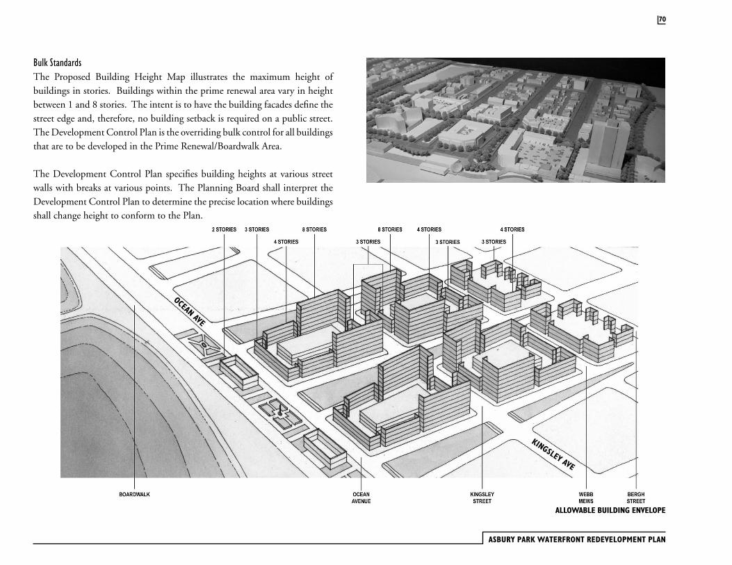
ASBURY PARK WATERFRONT REDEVELOPMENT PLAN
Bulk StandardsThe Proposed Building Height Map illustrates the maximum height of buildings in stories. Buildings within the prime renewal area vary in height between 1 and 8 stories. The intent is to have the building facades define the street edge and, therefore, no building setback is required on a public street. The Development Control Plan is the overriding bulk control for all buildings that are to be developed in the Prime Renewal/Boardwalk Area.
The Development Control Plan specifies building heights at various street walls with breaks at various points. The Planning Board shall interpret the Development Control Plan to determine the precise location where buildings shall change height to conform to the Plan.
ALLOWABLE BUILDING ENVELOPE
70
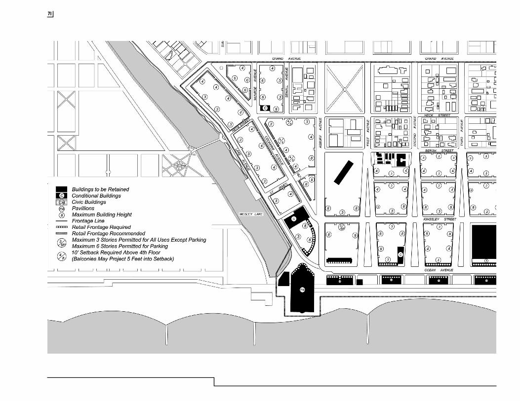
71
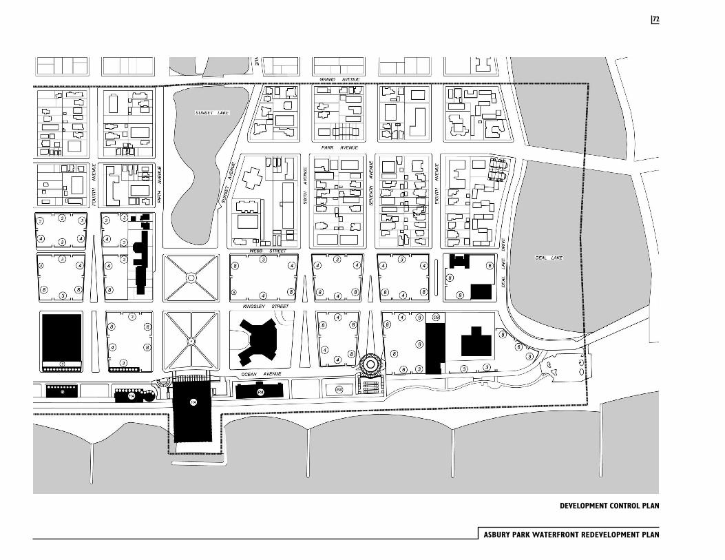
ASBURY PARK WATERFRONT REDEVELOPMENT PLAN
DEVELOPMENT CONTROL PLAN
72
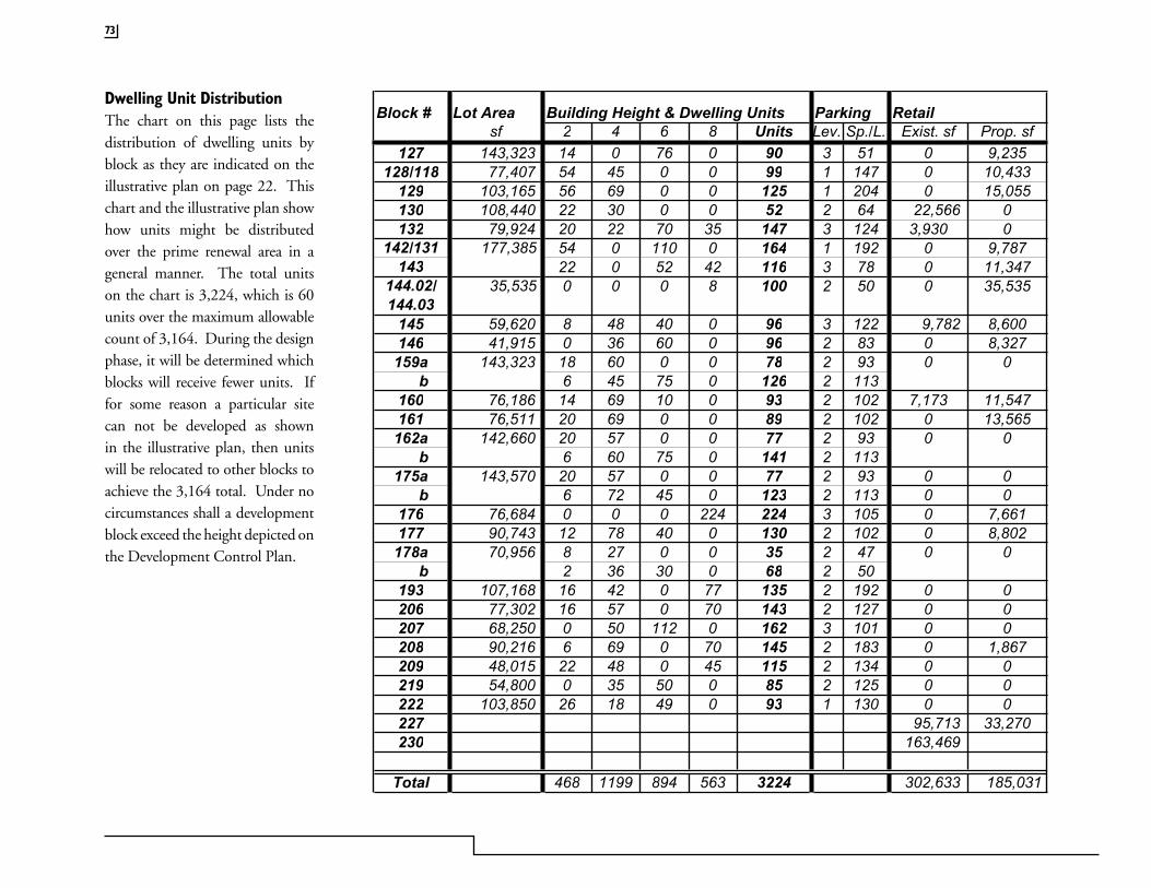
73
Block # Lot Area Building Height & Dwelling Units Parking Retailsf 2 4 6 8 Units Lev. Sp./L. Exist. sf Prop. sf
127 143,323 14 0 76 0 90 3 51 0 9,235128/118 77,407 54 45 0 0 99 1 147 0 10,433
129 103,165 56 69 0 0 125 1 204 0 15,055130 108,440 22 30 0 0 52 2 64 22,566 0132 79,924 20 22 70 35 147 3 124 3,930 0
142/131 177,385 54 0 110 0 164 1 192 0 9,787143 22 0 52 42 116 3 78 0 11,347
144.02/ 35,535 0 0 0 8 100 2 50 0 35,535144.03
145 59,620 8 48 40 0 96 3 122 9,782 8,600146 41,915 0 36 60 0 96 2 83 0 8,327159a 143,323 18 60 0 0 78 2 93 0 0 b 6 45 75 0 126 2 113160 76,186 14 69 10 0 93 2 102 7,173 11,547161 76,511 20 69 0 0 89 2 102 0 13,565162a 142,660 20 57 0 0 77 2 93 0 0 b 6 60 75 0 141 2 113175a 143,570 20 57 0 0 77 2 93 0 0 b 6 72 45 0 123 2 113 0 0176 76,684 0 0 0 224 224 3 105 0 7,661177 90,743 12 78 40 0 130 2 102 0 8,802178a 70,956 8 27 0 0 35 2 47 0 0 b 2 36 30 0 68 2 50193 107,168 16 42 0 77 135 2 192 0 0206 77,302 16 57 0 70 143 2 127 0 0207 68,250 0 50 112 0 162 3 101 0 0208 90,216 6 69 0 70 145 2 183 0 1,867209 48,015 22 48 0 45 115 2 134 0 0219 54,800 0 35 50 0 85 2 125 0 0222 103,850 26 18 49 0 93 1 130 0 0227 95,713 33,270230 163,469
Total 468 1199 894 563 3224 302,633 185,031
Dwelling Unit DistributionThe chart on this page lists the distribution of dwelling units by block as they are indicated on the illustrative plan on page 22. This chart and the illustrative plan show how units might be distributed over the prime renewal area in a general manner. The total units on the chart is 3,224, which is 60 units over the maximum allowable count of 3,164. During the design phase, it will be determined which blocks will receive fewer units. If for some reason a particular site can not be developed as shown in the illustrative plan, then units will be relocated to other blocks to achieve the 3,164 total. Under no circumstances shall a development block exceed the height depicted on the Development Control Plan.
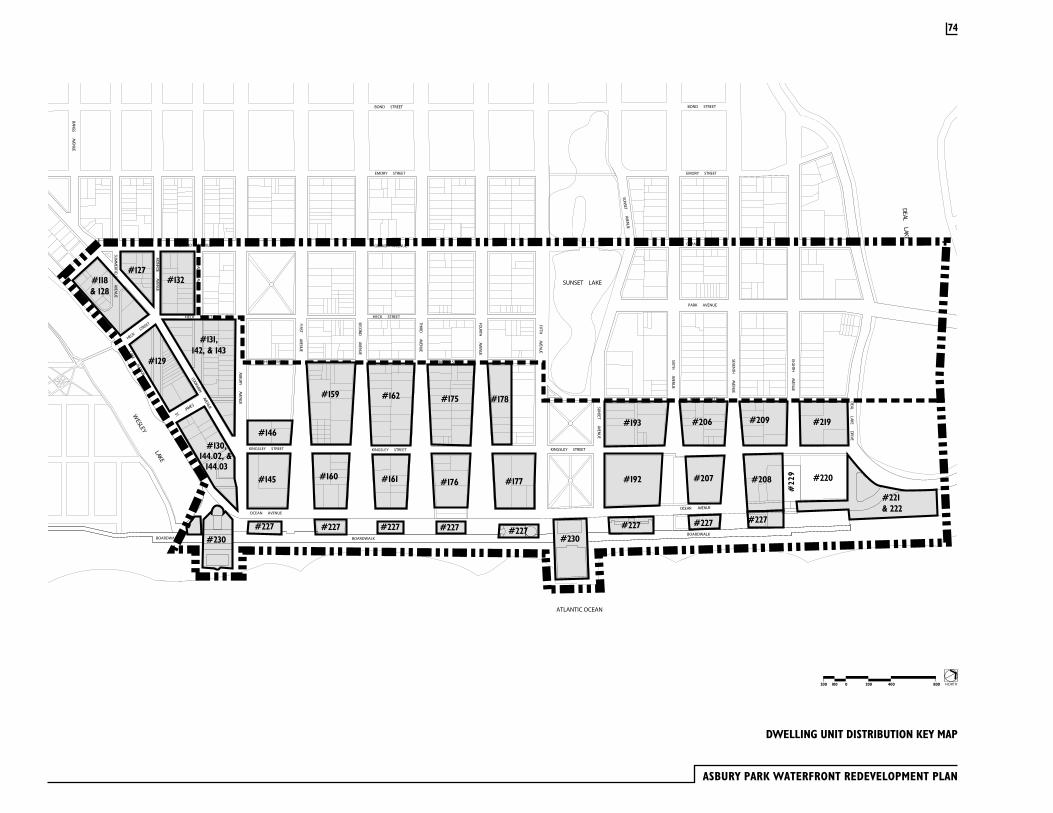
ASBURY PARK WATERFRONT REDEVELOPMENT PLAN
74
DWELLING UNIT DISTRIBUTION KEY MAP
922#
��
��� �
� ��� ��
��� �
�
��
� ���
����� �
����
���
��
����
���� ��
���
���
��
����
� �����
����
�
��
����
������
���
���
��������������
����
������
����
� ��� ��
� ���
�
�����������������
��
����
���� ��
���
���
��
��� �
� ��� ��
���
���
��
� ���
����� �
��
��� �
��
����
� ��� ��
���
��
����������������
��������������������
��
����
���� ��
����
��
����
�����
�����
����
�
��������������
��
����
����� �
���
���
��
� ���
�� �� ��
���
��
�
��
����
�� ��� �
� ���
���
��
��
�����������������
����
�����
�����
��
�����������������
��
����
������
��� �
�
����������������
�����������������
�����������������
����������������
�����������������
��������������������
�����������������
����
������
������
����
���
�
����������������
����������������
�����������������������������������������������������������������
����������������
����������������
��
����
����� �
��
���
��
����
� �����
�� �
��� �
�
�����������������
����������
��������� ������������������
��������������
����������������
����������������
�����������������
��������������������
���
�����
���
�
#131,142, & 143
#127#118& 128
#129
#130,144.02, &
144.03
#146
#145
#227
#159
#160
#162
#161
#175
#176
#178
#177
#227 #227 #227 #227#227 #227
#193 #206
#207
#209 #219
#208
#221& 222
#132
#227
#220#192
#230 #230
NORTH2000100200 400 800

75
300 Ocean MileIn 1988, the original prime developer for the Asbury Park waterfront started construction on a 224 unit condominium building on the block (#176) between Third and Fourth Avenues and between Kingsley Street and Ocean Avenue. Before the project was completed, it went bankrupt and has stood vacant for many years. The original plan called two residential buildings to be constructed over a garage structure containing 458 parking spaces. On the north side the building would be 16 stories high (164 feet) and in the south side the building would be 10 stories (102 feet).
The design of this structure is out of character with the objectives of this plan. First, the structure would have eliminated Ocean Avenue as a street by building out to the pavilion block between Third and Fourth Avenues. Second, the Ocean Mile is taller than buildings proposed in this plan. Third, the building’s façade which is composed of balconies, pre-cast concrete panels and sliding glass doors bears no relationship to the design image Asbury Park wants to implement.
Owners of the Ocean Mile will be allowed to finish the construction of this 224 unit project provided that: 1.) The parking structure is cut back to restore Ocean Avenue’s original right-of-way 2.) The building’s façade is redesigned to be more compatible with the architectural standards of this plan. Balconies on this building may exceed a 3 foot depth.
Wesley Lake Village AlternativesTwo alternative design concepts have been developed for the area between Cookman Avenue and Lake Avenue adjoining Wesley Lake. Both alternatives place low-rise buildings (2-3 stories) along Lake Avenue and higher buildings (4 stories) along Cookman Avenue.
Alternative I proposes traditional townhouses along Lake Avenue and uses the projection Summerfield Avenue and Monroe Avenue as pedestrian spaces within the development block.
Alternative II shows Summerfield Avenue as a vehicular street extending to Lake Avenue and proposes six new small streets between Cookman and Lake Avenues.
The developer will review these alternatives in greater detail and make a proposal on how best to develop this important site taking into consideration its relationship to Wesley Lake and Cookman Avenue. The final design proposal shall provide visual and pedestrian connections between Cookman and Lake Avenue, but the projection of Summerfield and Monroe Avenues shall not be a requirement. Pedestrian passages shall conform to the thoroughfare standards.
PROPOSED BUILDING COMPLETION WESLEY LAKE SHOWING THE BOAT RIDE
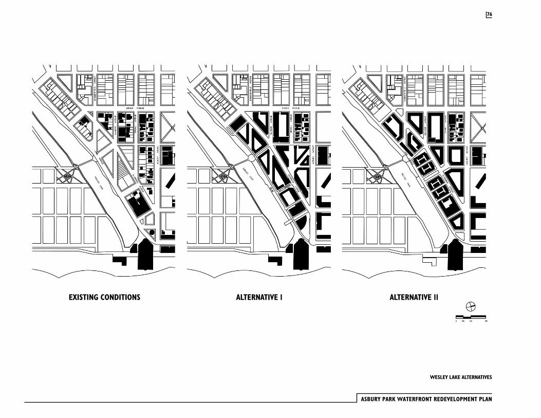
ASBURY PARK WATERFRONT REDEVELOPMENT PLAN
76
EXISTING CONDITIONS ALTERNATIVE 1 ALTERNATIVE 11
WESLEY LAKE ALTERNATIVES
The Asbury Park Waterfront Redevelopment Plan will require planned upgrades to the existing infrastructure in order to accommodate the proposed development and ensure a reliable utility base for the City of Asbury Park. The involved utilities are as follows:
· Electrical service – GPU
· Telecommunications – Verizon
· Cable TV – Cablevision
· Water Distribution – New Jersey American Water Company
· Natural Gas – New Jersey Natural Gas
· Sanitary Sewer – City of Asbury Park
· Storm Sewer – City of Asbury Park
Necessary modifications to the existing above ground utilities will include upgrades for capacities and actions to locate above- ground facilities below grade. The below-grade modifications and construction will require continuous coordination for all utilities to provide un-interrupted service and efficient construction practices.
A new underground electric trunk line will be installed along Cookman Avenue and Kingsley Street, and service new construction on either side of the Avenues. Above ground electric supply splitter boxes will be located in the landscaped street medians along Cookman Avenue and Kingsley Street. Existing and new buildings along the edge of the prime renewal area will continue to receive electric power from above-ground lines. Locations where above lines are to remain include: Webb, Bergh, Heck Streets and one block of Sewall Avenue.
The majority of below-grade utilities were installed in the late 1930’s and early 1940’s. The existing sanitary sewer system is comprised, primarily, of clay tile pipe. Based upon physical inspections of all manhole structures, it is apparent that removal and replacement of a majority of the 8” diameter mains will be required. The sanitary sewer mains are the deepest facilities that
exist and, therefore, the excavations related to the sanitary facilities are expected to impact portions of the water distribution, natural gas and storm sewer systems. It is anticipated that the cast iron natural gas mains and the clay tile storm sewer mains will be reconstructed within the Asbury Park Waterfront Redevelopment area. The water distribution system will require modifications to eliminate existing undersized mains and potential upgrades for future construction, based upon fire flow analyses.
Storm Sewer SystemIn order to eliminate ponding of stormwater runoff within the Asbury Park Waterfront Redevelopment Area and to enhance the water quality of surface runoff discharged into Wesley, Sunset and Deal Lakes, the existing storm sewer system will need to be reconstructed / rehabilitated. Much of the storm system is in poor structural condition, exhibits capacity problems, and is undersized. Portions of the redevelopment area do not have existing storm sewers. This combination of factors overloads facilities down-gradient during significant storm events and leads to ponding problems during normal rainfall events. There are multiple storm water inlets to Wesley, Sunset and Deal Lakes that drain the redevelopment area with no provisions for water quality in the existing storm system. Pollutants and debris discharged into the lakes impacts aquatic animals, vegetation and the overall health and character of the lakes. In order to improve the storm water characteristics within the redevelopment area, new catch basins and piping will be installed where required. Existing undersized piping will be replaced with larger diameter piping. Existing structures and piping that are to remain will be cleaned and repaired as necessary in order to provide efficient stormwater conveyance.
Stormwater quality will be enhanced through the removal of sediment and pollutants from surface runoff through the installation of in-line water quality treatment structures. Each water quality unit will be strategically located within the storm sewer system and sized to effectively remove pollutants generated from within the public right-of-way, and to convey stormwater runoff from the entire drainage area. This will require rerouting
3.9 Public Utilities
77
ASBURY PARK WATERFRONT REDEVELOPMENT PLAN
3.10 Environmental Contamination
storm lines and the elimination of some lake infalls to optimize the efficiency of the treatment units. Water quality will also have to be addressed by individual developers on a case-by-case basis for improvements outside the public right-of-way.
Ultimately, the modifications to the stormwater management systems will have an immediate and permanent positive impact to the overall water quality on all three lakes.
Sanitary Sewer SystemInflow and infiltration is a concern of the existing Asbury Park sanitary sewer system. Flows to the sanitary treatment plant substantially increase during rainfall events, ultimately increasing the discharge to the Atlantic Ocean.
Inspection of the sanitary sewer within the redevelopment area revealed that the original clay pipes within the system are cracked, compressed and need to be replaced or rehabilitated. The cracked and damage pipes are sources of the inflow and infiltration experienced by the system. Also, it is suspected that there are a number of unsealed, abandoned laterals and non-sanitary connections to the sewer, which compound inflow and infiltration. These and damaged sections of pipe allow silt to accumulate in the system, which blocks the passage of solids, reduces flow capacities, promulgates odors and hastens the accumulation of sewer gases.
Attaining acceptable sanitary facilities is paramount to the vitality of the waterfront redevelopment area. This will be achieved through the rehabilitation of salvageable portions of the existing system. Damaged sections of the system, along with those sections that are experiencing severe problems, will be replaced. Abandoned and non-sanitary connections will be identified, sealed and rerouted as required.
The City of Asbury Park’s waterfront redevelopment area was formerly comprised of retail, commercial and residential uses. The potential exists for environmental contamination to be present as a result of historical uses, including underground tanks used for the on-site storage of fuel. Consequently, the developer has retained the services of an environmental consultant knowledgeable of the historical uses and environmental conditions in the waterfront redevelopment area. The consultant has performed preliminary environmental investigations of former commercial/retail properties with the goal of identifying areas of environmental concern that may contribute to soil and groundwater contamination. Environmental investigations that have been, and continue to be, conducted are in general accordance with applicable ASTM standards or New Jersey Department of Environmental Protection regulations. The objective of conducting these investigations is to address environmental conditions prior to property transfer to facilitate future redevelopment.
78

IMPLEMENTATION
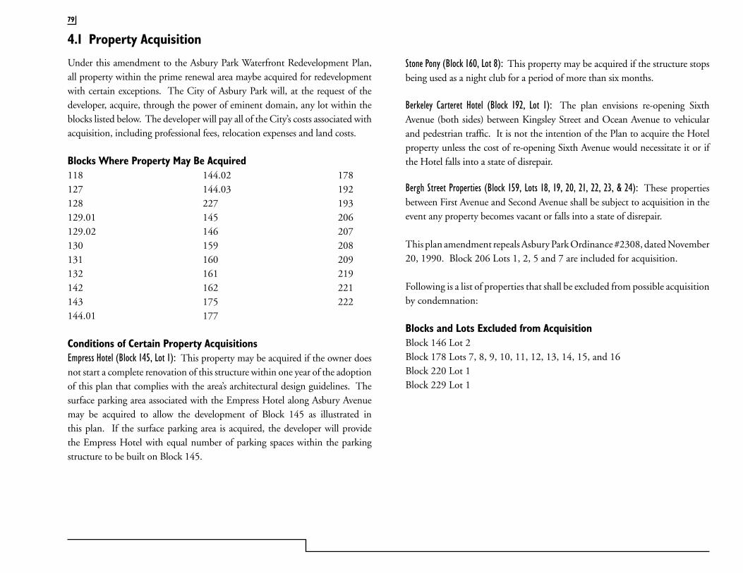
4.1 Property Acquisition
Under this amendment to the Asbury Park Waterfront Redevelopment Plan, all property within the prime renewal area maybe acquired for redevelopment with certain exceptions. The City of Asbury Park will, at the request of the developer, acquire, through the power of eminent domain, any lot within the blocks listed below. The developer will pay all of the City’s costs associated with acquisition, including professional fees, relocation expenses and land costs.
Blocks Where Property May Be Acquired118 144.02 178127 144.03 192128 227 193129.01 145 206129.02 146 207130 159 208131 160 209132 161 219142 162 221143 175 222144.01 177
Conditions of Certain Property AcquisitionsEmpress Hotel (Block 145, Lot 1): This property may be acquired if the owner does not start a complete renovation of this structure within one year of the adoption of this plan that complies with the area’s architectural design guidelines. The surface parking area associated with the Empress Hotel along Asbury Avenue may be acquired to allow the development of Block 145 as illustrated in this plan. If the surface parking area is acquired, the developer will provide the Empress Hotel with equal number of parking spaces within the parking structure to be built on Block 145.
79
Stone Pony (Block 160, Lot 8): This property may be acquired if the structure stops being used as a night club for a period of more than six months.
Berkeley Carteret Hotel (Block 192, Lot 1): The plan envisions re-opening Sixth Avenue (both sides) between Kingsley Street and Ocean Avenue to vehicular and pedestrian traffic. It is not the intention of the Plan to acquire the Hotel property unless the cost of re-opening Sixth Avenue would necessitate it or if the Hotel falls into a state of disrepair.
Bergh Street Properties (Block 159, Lots 18, 19, 20, 21, 22, 23, & 24): These properties between First Avenue and Second Avenue shall be subject to acquisition in the event any property becomes vacant or falls into a state of disrepair.
This plan amendment repeals Asbury Park Ordinance #2308, dated November 20, 1990. Block 206 Lots 1, 2, 5 and 7 are included for acquisition.
Following is a list of properties that shall be excluded from possible acquisition by condemnation:
Blocks and Lots Excluded from AcquisitionBlock 146 Lot 2Block 178 Lots 7, 8, 9, 10, 11, 12, 13, 14, 15, and 16Block 220 Lot 1Block 229 Lot 1
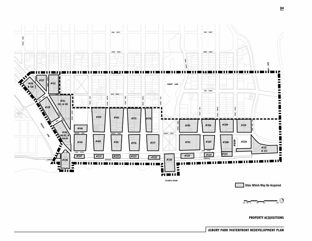
ASBURY PARK WATERFRONT REDEVELOPMENT PLAN
PROPERTY ACQUISITIONS
#229
Sites Which May Be Acquired
SIXTH AVENUE
SEVENTH AVENUE
EIGHTH AVENUE
FIFTH AVENUE
SUNSET AVENUE
SUNSET LAKE
DEAL LAKE DRIVE
GRAND AVENUE
SUNSET AVENUE
FOURTH AVENUE
SECOND AVENUE
THIRD AVENUE
HECK STREET
KINGSLEY STREET
ASBURY AVENUE
COOKMAN AVENUE
ST. JA
MES
SEWALL AVENUE
MONROE AVENUE
SUMM
ERFIELD AVENUE
EMORY STREET
LAKE AVENUE
BERGH STREET
FIRST AVENUE
WEBB STREET
OCEAN AVENUE
GRAND AVENUE
PARK AVENUE
EMORY STREET
KINGSLEY STREET
OCEAN AVENUE
WESLEY LAKE
BOND STREET
MAIN STREET
NEW YORK & LONG BRANCH RAILROAD CO.
BOND STREET
MAIN STREET
BANGS AVENUE
MATTISON AVENUE
GRAND AVENUE
OCEANGROVE
BOARDWALK BOARDWALKBOARDWALK
ATLANTIC OCEAN
HECK STREET
HECK ST
REET
BERGH STREET
KINGSLEY STREET
DEAL LAKE
#131,142, & 143
#127#118& 128
#129
#130,144.02, &
144.03
#146
#145
#227
#159
#160
#162
#161
#175
#176
#178
#177
#227 #227 #227 #227#227 #227
#193 #206
#207
#209 #219
#208
#221& 222
#132
#227
#220#192
#230 #230
NORTH2000100200 400 800
80
Implementation of the Redevelopment Plan will require the acquisition of private property and the relocation of owners and tenants. In such situations, prior to any relocation activities, the city will comply with applicable provisions of the Relocation Assistance law of 1967, N.J.S.A. 52:31B-1 et seq. and the Relocation Assistance Act, N.J.S.A. 20:4-1 et seq., the Relocation Assistance and Eviction Regulations of the Department of Community Affairs, N.J.A.C. 5:11-1.1 et seq.
No relocation activities may take place until a Workable Relocation Assistance Program (WRAP) plan is prepared and approved by the Department of Community Affairs. The WRAP plan must include measures, facilities or services as are necessary in order to:
1. Determine the needs of the displacees;
2. Assist displacees in obtaining replacement housing and business locations;
3. Provide an analysis of federal, state and local programs affecting the availability of housing;
4. Secure the coordination of relocation activities with other displacing agencies;
5. Assist in minimizing hardships to displacees;
6. Determine the extent of the need of each displacee for relocation assistance;
7. Assure the availability of decent, safe and sanitary replacement housing;
8. Determine the source, amount and availability of funds necessary to complete relocation;
9. Provide any other information deemed necessary by the Department of Community Affairs to insure the provisions of the Relocation Assistance Act are carried out.
A Workable Relocation Assistance Plan will be prepared for the whole renewal area prior to any relocation.. The City shall meet with the New Jersey Office of the Public Advocate to discuss relocation. It is anticipated that the cost of relocation will be borne by the displacing agency, although the displacing agency may apply for, and receive, grants to cover the cost or portion thereof, or arrange for relocation costs to be borne by a developer or another party.
The overall acquisition and relocation activity required within the prime renewal area includes the following activities:
· 453 occupied apartment units located in 33 structures will be acquired and tenants relocated
· 22 single family homes will be acquired and tenants or owners relocated
· 193 rooming house units located in 4 structures will be acquired and tenants relocated
· 18 business operations will be acquired and tenants or owners relocated
4.2 Workable Relocation Assistance Plan (WRAP)
81
ASBURY PARK WATERFRONT REDEVELOPMENT PLAN
Since the City of Asbury Park, currently, has no outstanding fair-share housing obligation under the NJ Fair Housing Act, and will address any foreseeable additional obligations through housing rehabilitation, new residential development within the Waterfront Redevelopment Area is not required under the Fair Housing Act to include an affordable housing component. However, the prime developer shall agree to provide affordable housing units for low and moderate income households equal to five percent (5%) of the new housing units built within the prime renewal area. These housing units may either be built by the prime developer or a subsidiary corporation. Alternately, the prime developer may donate a lump sum payment for each required affordable housing unit to the City or a housing sponsor designated by the City. The amount of this payment will be defined in the developer’s agreement with the City. The required affordable housing units may be built on any appropriate site in Asbury Park.
The following discussion provides details on the manner in which Asbury Park’s housing obligation was determined.
The Fair Housing Act, P.L. 1985, c. 222 (C.52:27D-301 et. seq.) requires each municipality in New Jersey to provide a realistic opportunity for its fair share of the regional need for housing affordable to low and moderate income households. The Act created the New Jersey Council on Affordable Housing (hereinafter “COAH”) as the State agency responsible for implementation.
COAH periodically calculates the need for affordable housing for households of low and moderate income and allocates the need among the respective regions and municipalities. Asbury Park is located in the East Central Housing Region, which is comprised of Mercer, Monmouth and Ocean Counties.
COAH’s current calculation of housing need covers the period 1987-1999. COAH has not yet been able to estimate housing need for 2000 and beyond
since these calculations depend upon data that has yet to be released from the year 2000 U.S. Census.
Housing need has been defined by COAH as having the following key components: Indigenous Need, Reallocated Present Need, Present Need and Prospective Need. Indigenous Need refers to the number of dwellings within Asbury Park that are in substandard condition and are inhabited by low- or moderate- income households. This number is estimated from U.S. Census housing surrogates, which substitute for an actual count. Asbury Park had an Indigenous Need for 1987-1999 of 156 units.
COAH adjusts each municipality’s Indigenous Need by assessing the extent of Spontaneous Rehabilitation that has occurred within the time frame of the housing needs analysis. Spontaneous Rehabilitation refers to the reconstruction of the existing housing stock to meet building and habitability code requirements that has occurred through the operation of normal market forces. The number of substandard units which have been “spontaneously” rehabilitated since the 1990 Census is deducted from the municipal Indigenous Need to yield the net Rehabilitation Component of the municipal fair share allocation. COAH has calculated that 158 units were spontaneously rehabilitated in Asbury Park. Consequently the City’s entire Indigenous Need for 1987-1999 of 156 units is offset by Spontaneous Rehabilitation and the City’s Rehabilitation Component is zero.
Reallocated Present Need is determined by establishing, initially, an average of Indigenous Need as a percentage of all occupied housing units within each housing region. Where communities’ percentage of deficient housing exceeds the regional average, the excess need is assigned to a regional housing “pool” for subsequent redistribution within the region.
Housing need from the pool of excess Indigenous Need is reallocated to all municipalities in the region with the exception of designated Urban Aid Cities. These cities are excluded since they have been statistically determined
4.3 Affordable Housing
82
to already house a disproportionately high share of the region’s poor. Allocating additional affordable housing units to Urban Aid Cities would be contrary to the Mount Laurel doctrine established by the State’s judiciary, the Fair Housing Act and the NJ State Plan.
Asbury Park is one of only six municipalities in COAH’s East Central Housing Region that is designated as an Urban Aid City. As such, it does not receive an allocation from the regional housing pool of excess Indigenous Need; therefore the City has a Reallocated Present Need of zero.
Prospective Need is comprised of the future households of low and moderate income who will be seeking housing in the region during the assessment period. This housing need component consists of new household formation net in-migration to the region.
Like Reallocated Present Need, Prospective Need is allocated to all municipalities within the region except for Urban Aid Cities. Consequently, Asbury Park does not receive an allocation of the 1987-1999 growth in the number of low- and moderate- income households; the City has a Prospective Need of zero. As indicated, COAH anticipates releasing fair share housing obligations covering 2000 and beyond in the next year. However, based on COAH policy to date, any additional affordable housing obligation that may be allocated to Asbury Park will be related to the existence of substandard housing units occupied by low- and moderate- income households. The City expects to be able to address any such obligation through ongoing housing rehabilitation programs.
In 1984, New Jersey, like many other states, enacted legislation that permitted municipalities to establish Special Improvement Districts that would enable the creation of self-help strategies to enhance and revitalize downtowns. A Special Improvement District (SID) is an organization and financing tool used by local property owners, in partnership with the municipality, to provide specialized services such as management, marketing, recruitment, security, physical improvements, special events and maintenance.The City of Asbury Park intends to create a SID to implement physical improvements and a maintenance program for the Boardwalk and Prime Renewal Areas. The SID may be used to finance the reconstruction of Boardwalk and Bradley Park as outlined in this plan. The prime developer may loan the SID funds to pay for physical improvements, which would be reimbursed to the prime developer by the SID.
Upon compliance with the requirement of applicable law, the City of Asbury Park acting as a redevelopment authority, subject to study and recommendation of the Planning Board of the City of Asbury Park, may amend, revise or modify this Plan at any time, provided that, in respect to any land in the Redevelopment Area previously disposed of by the City for redevelopment in accordance with the provisions of the plan, the City Council must first receive the written consent of such purchaser(s), or lessee(s) or their successor(s) in interest(s), whose land(s) in the sole opinion of the Redevelopment Agency would be adversely affected by amendment, revision or modification of the plan.
This plan and amendments, revisions or modifications thereof shall be in full force and effect for a period of thirty (30) years from the date of approval of this plan by the City Council.
4.5 Amending the Waterfront Redevelopment Plan
4.6 Termination of Redevelopment Plan
4.4 Special Improvement District (SID)
83
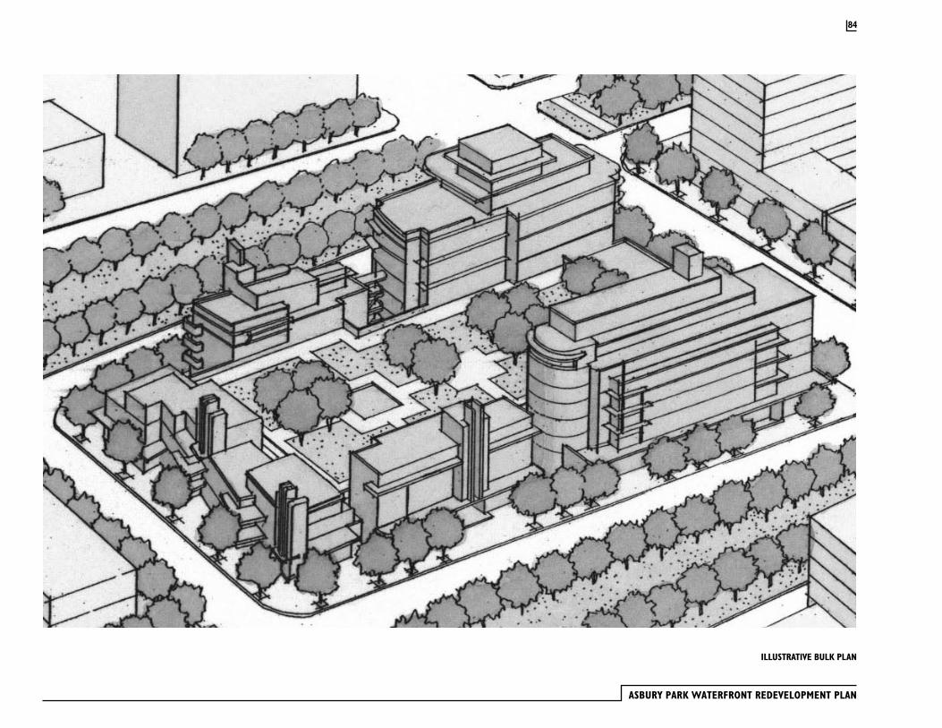
ASBURY PARK WATERFRONT REDEVELOPMENT PLAN
84
ILLUSTRATIVE BULK PLAN

RELATIONSHIP TO OTHER PLANS
5.1 New Jersey State Development and Redevelopment Plan (State Plan)
Pursuant to 40A:12A-7.a (5), a redevelopment plan shall include a discussion that examines:
Any significant relationship of the redevelopment plan to (a) the master plans of contiguous municipalities, (b) the master plan of the county in which the municipality is located, and (c) the State Development and Redevelopment Plan adopted pursuant to the “State Planning Act”, P.L.1985, c. 398 (C.52:18A-196 et. seq.).
This section examines the relationship between the Waterfront Redevelopment Plan and the New Jersey State Plan and the Asbury Park Master Plan. In each of these cases, the Waterfront Redevelopment Plan is substantially consistent. The New Jersey State Plan, first adopted in 1992 and updated in March 2001, is a comprehensive statewide guide to municipal, county and regional planning. It contains vision statements, goals, strategies and policies. The overall goals of the State Plan were derived from the State Planning Act:
1. Revitalize the State’s Cities and Towns.
2. Conserve the State’s Natural Resources and Systems
3. Promote Beneficial Economic Growth, Development and Renewal for All Residents of New Jersey
4. Protect the Environment, Prevent and Clean Up Pollution
5. Provide Adequate Public Facilities and Services at a Reasonable Cost
6. Provide Adequate Housing at a Reasonable Cost
7. Preserve and Enhance Areas with Historic, Cultural, Scenic, Open Space and Recreational Value1
The State plan has formulated a series of policies stemming from these goals. These polices are keyed to the State Plan Policy Map. The policy map identifies areas for growth, agriculture, open space and conservation. These areas are called planning areas, which are characterized as large masses of land in excess of one (1) square mile that share a common set of conditions. The State Plan planning areas are summarized as follows:
Metropolitan Planning Area: PA1Provide for much of the state’s future redevelopment; revitalize cities and towns; promote growth in compact forms; stabilize older suburbs; redesign areas of sprawl; and protect the character of existing stable communities.
Suburban Planning Area: PA2Provide for much of the state’s future development; promote growth in Centers and other compact forms; protect the character of existing stable communities; protect natural resources; redesign areas of sprawl; reverse the current trend toward further sprawl; and revitalize cities and towns.
Fringe Planning Area: PA3Accommodate growth in Centers; protect the Environs primarily as open lands; revitalize cities and towns; protect the character of existing stable communities; protect natural resources; provide a buffer between more developed Metropolitan and Suburban Planning Areas and less developed Rural and Environmentally Sensitive Planning Areas; and confine programmed sewers and public water services to Centers.
Rural Planning Area: PA4, and the Rural/Environmentally Sensitive Planning Area: PA4B Maintain the Environs as large contiguous areas of farmland and other lands; revitalize cities and towns; accommodate growth in Centers; promote a viable agricultural industry; protect the character of existing stable communities; and confine programmed sewers and public water services to Centers.
1 New Jersey State Planning Commission. March 2001. The New Jersey State Development and Redevelopment Plan. p.7
85
ASBURY PARK WATERFRONT REDEVELOPMENT PLAN
Environmentally Sensitive Planning Area: PA5, and the Environmentally Sensitive/Barrier Island Planning Area: PA5B Protect environmental resources, through the protection of large contiguous areas of land; accommodate growth in Centers; protect the character of existing stable communities; confine programmed sewers and public water services to Centers; and revitalize cities and towns.2
Asbury Park’s waterfront redevelopment area lies within the Metropolitan Planning Area PA1, the area designated to bear the highest share of New Jersey’s redevelopment. PA1 includes the State’s older, developed cities, towns and urban centers, such as Asbury Park, which are in need of reinvestment ,but where most of the necessary infrastructure is already in place. As indicated, the State Plan envisions this area to accommodate much of the State’s redevelopment while revitalizing cities and towns, promoting growth in compact forms and protecting the character of established communities. The Waterfront Redevelopment Plan is consistent with these objectives and with the specific policies applicable to the Metropolitan Planning Area.
Statewide PoliciesThe State Plan includes 19 Statewide Policies that are intended to improve planning and coordination of public policies through county, municipal and regional government. The statewide polices address specific land use issues that are of particular importance within New Jersey. These are:
1. Equity
2. Comprehensive Planning
3. Public Investment Priorities
4. Infrastructure Investments
5. Economic Development
6. Urban Revitalization
7. Housing
8. Transportation
9. Historic, Cultural and Scenic Resources
10. Air Resources
11. Water Resources
12. Open Lands and Natural Systems
13. Energy Resources
14. Waste Management, Recycling and Brownfields
15. Agriculture
16. Coastal Resources
17. Planning Regions Established by Statute
18. Special Resource Areas
19. Design3
The State Plan applies these policies to each of the planning areas in a manner particular to the specific area. The following statewide policies are relevant to the Waterfront Redevelopment Plan
Revitalize the State’s Cities and TownsThe State Plan encourages the revitalization of cities and towns. The Waterfront Redevelopment Plan is consistent with the large-scale urban revitalization strategies of the State Planning Commission that encourage inter-municipal coordination and cooperation. The State Plan also identifies local redevelopment plans, such as the Waterfront Redevelopment Plan, as an appropriate tool for the revitalization of urban areas.
2 New Jersey State Plan p.1513 New Jersey State Plan. p.84
86
Comprehensive PlanningThe State Plan calls for the undertaking of comprehensive planning in order to implement State-planning goals. The Waterfront Redevelopment Plan is comprehensive in that is provides for the detailed redevelopment of Asbury Park’s waterfront on several levels, including land use, vehicular circulation, utilities, open space, recreation, natural resource management, public transportation, architecture and design. It is also consistent with local and regional plans.
Public Investment PrioritiesThe State Plan envisions that public investments will be used to guide growth in centers. The plan for Asbury Park’s waterfront redevelopment area sets the stage for both public and private investment within the City and Monmouth County. The State Plan ranks PA-1, Metropolitan Planning Area high with respect to the provision of State funding for the purposes of infrastructure maintenance and repair, capacity expansion and planning resources.
Urban RevitalizationThe State Plan places significant focus on the revitalization of New Jersey’s urban areas, which are key in the maintenance of the existing centers in the State. Asbury Park’s redevelopment is consistent the State Plan policies on urban revitalization:
The plan has been developed with input and coordination among various stakeholders.
The plan seeks to develop public facilities, including public transportation elements, which will encourage growth and investment.
Design guidelines for Asbury Park’s waterfront redevelopment area promote the development of a mixed-use village that will be visually appealing and spatially functional. The design criteria will enhance the waterfront areas, gateways, streets and neighborhoods.
The proposed design of Asbury Park’s waterfront redevelopment area will result in the development of a compact, mixed-use village, which thoughtfully reestablishes the original, unique layout of city streets as set forth in the Bradley Plan.
The Waterfront Redevelopment Plan contains density and bulk controls, along with other land use regulations, to ensure that the revitalization effort is successful.
Existing historic buildings within the waterfront redevelopment area, including the Casino and Convention Hall, are planned for expanded roles within the community.
The Waterfront Redevelopment Plan includes several housing types, including low-rise townhouses and mid-rise apartments. The Waterfront Redevelopment Plan includes the provision of new public open spaces and enhancements to existing open space areas, such as Wesley Lake, the Boardwalk and Bradley Park.
Open Space and Coastal ResourcesThe State Plan seeks to provide adequate recreational and open space and to maintain and improve and encourage public waterfront access. The Waterfront Redevelopment Plan is consistent with the State Plan in that it continuous public access to the waterfront will be provided through the extension and improvement of the oceanfront Boardwalk. The design of streets within the waterfront redevelopment area will enhance connectivity between the upland neighborhoods and the beachfront.
DesignThe State Plan encourages well-designed places that are aesthetically pleasing and contribute to a good quality of life. This includes mixing of uses, use of design guidelines, creating places with distinct identities, establishing interconnected circulations systems, creating civic buildings and spaces, using
87
ASBURY PARK WATERFRONT REDEVELOPMENT PLAN
special design elements and reducing the visual impact of the automobile. The Waterfront Redevelopment Plan is consistent with these policies. It is the plan for a high-density mixed-use village that will be developed according to a layout that will support a high quality of life. Redevelopment of the waterfront area will also be governed by detailed design guidelines.
CentersThe State Plan contains a series of policies that are related to the areas classified as centers. Centers are defined as:
… a compact form of development with one or more Cores and residential neighborhoods. Centers range in scale from an Urban Center, to a Regional Center, Town Center, Village, and Hamlet. 4
Although identified as a regional center in the 1992 State Plan, Asbury Park has not been formally designated as a center at this time. Presently, centers can only be designated as part of a plan endorsement process, through the Office of State Planning. The State Planning Commission has recently adopted guidelines and rules for the plan endorsement process, which is a way for the State Planning Commission to certify that a municipality’s planning documents are consistent with those of the State Plan. Should Asbury Park proceed with plan endorsement subsequent to the adoption of the Waterfront Redevelopment Plan, it is anticipated that it would be found to be consistent with the centers policies of the State Plan and could be formally designated as such.
Recent Asbury Park planning documents have been adopted incrementally, with the latest group still in draft form. These include:
1990 Historic Preservation Element Housing Element (no date)1994 Land Use Element1995 Strategic Revitalization Plan2001 Recreation and Conservation Element (draft) Solid Waste Recycling Element (no date)2001 Reexamination Report of the Master Plan and Land Development Ordinance (draft)
This section will examine the relevant goals, objectives and policies within these planning documents in order to determine the consistency between these and the Waterfront Redevelopment Plan (WRP).
The Reexamination recommends that the Master Plan be amended to be consistent with the 1994 Land Use Element, both in terms of density and in terms of scale:
Amend the Waterfront Redevelopment Plan to be consistent with the 1994 Land Use Element of the Master Plan. Modify land uses and development parameters within the Waterfront redevelopment Plan and reduce the development intensity to a scale that is consistent with the following physical land use goal as articulated in the 1994 Land Use Element of the Master Plan:
An attractive and appealing oceanfront with a variety of daytime and evening entertainment and cultural events for families and convention goers combined with diverse lodging accommodations, including bed & breakfast inns, and new middle income residential development. 5
4 New Jersey State Planning Commission. March 2001. The New Jersey State Development and Redevelopment Plan. p.289
5.2 Asbury Park Master Plan
5 City of Asbury Park. June 14, 2001. Reexamination of the Master Plan and Land Development Ordinance (draft). Prepared by Schoor DePalma, Inc.. p25
88
The 1994 Land Use Element, referred to in the 2001 Reexamination, illustrates a vision of a renewed, dynamic, mixed –use oceanfront district. The Waterfront Redevelopment plan is substantially consistent with that vision in that it proposes a mixture of residential, retail, entertainment, cultural and hotel uses as a backdrop to the oceanfront anchor, the historic Boardwalk.
With respect to residential uses, the 1994 Land Use Element recommends a reduction in the overall height of residential structures within the Waterfront Redevelopment Area, stating “A significant reduction from a maximum height of 14 stories to a maximum height of 5 stories is planned” 6. The WRP is not wholly consistent with that recommendation, limiting the maximum height of residential structures to the existing height of the Berkeley-Carteret Hotel, which is eight (8) stories. However, most structures in the WRA will range in height from two (2) to five (5) stories. Although the maximum height of some buildings within the WRA will exceed the height envisioned by the 1994 Land Use Element, it is necessary in order to achieve a critical mass of housing density to support redevelopment. This density will also support the myriad public and private improvements included within the WRP, as well as, the enhanced urban design standards that will be applied to those improvements.
Going beyond residential land use issues, the 1994 Land Use Element set forth overall policies that are relevant to the Waterfront redevelopment Plan. From a physical perspective, the land use element seeks to preserve the unique characteristics that are identified with Asbury Park: the historic street plan, the beach and Boardwalk, historic architectural resources and the
overall visual character. The WRP is consistent with those policies, since it envisions a vibrant oceanfront district that is set upon the framework of the original Bradley Plan. The architecture within the Redevelopment Area will be subject to strict design and bulk controls to ensure that new construction supports the character of Asbury Park. It also incorporates the renovation and re-use of the major historic public buildings and the Boardwalk within the plan. The WRP embraces the public open spaces-Wesley Lake and Bradley Park- as part of a holistic vision.
The June 2001 Recreation & Conservation Element (draft) identifies a need to provide for bicycle routes and paths in a looped configuration within the Oceanfront, with connections to the shores of Wesley Lake and Sunset Lake Park. The WRP integrates designated bicycle lanes within some streets in the Redevelopment Area, consistent with the Recreation Element.
With the exception of the maximum height of residential structures, the WRP is substantially consistent with the Asbury Park Master Plan. While the Redevelopment Law (40A:12A-7.a (5)d.) states that “all provisions of the redevelopment plan shall be either substantially consistent with the municipal master plan or designed to effectuate the master plan”, it also states that:
“…the municipal governing body may adopt a redevelopment plan which is inconsistent with or not designed to effectuate the master plan by affirmative vote of a majority of its full authorized membership with the reasons for so acting set forth in the redevelopment plan.”
Those reasons are set forth herein.
6 City of Asbury Park. 1994. Land Use Element . p.15
89
ASBURY PARK WATERFRONT REDEVELOPMENT PLAN
The Monmouth County Planning Board has designated Asbury Park as a regional center. The Waterfront Redevelopment Plan is consistent with Monmouth County’s vision for revitalizing Asbury Park.
Municipalities lying adjacent to Asbury Park’s boundaries are Neptune Township, Ocean Township, Interlaken Borough, Allenhurst Borough and Loch Arbour Village. The waterfront redevelopment area of Asbury Park is adjacent, only, to Neptune Township (Ocean Grove) and Loch Arbour Village. The Waterfront Development Plan envisions no land use changes that would negatively impact the adjacent residential neighborhoods within Neptune or Loch Arbour. There are no significant relationships between the Waterfront Development Plan and the plans of the adjacent municipalities.
Development proposed for Asbury Park’s Waterfront Redevelopment Area will require approval from the New Jersey Department of Environmental Protection under the Coastal Area Facilities Review Act (CAFRA) NJSA 13:19-1 et seq. This amendment to the Redevelopment Plan takes into consideration the CAFRA regulations that apply to the area and, to the extent possible, incorporates these requirements into the Redevelopment Plan. The City and the developer intend to work with NJDEP on a detailed review of the City’s development controls for the redevelopment area, so that compliance with Redevelopment Plan will constitute substantial compliance with CAFRA regulations. The following is a summary of the key CAFRA regulations that apply to the redevelopment area:
7:7E - 3.16 DunesDevelopment is prohibited on dunes, except for development that has no practicable or feasible alternative. The Redevelopment Plan does not allow development on any dunes. The Plan does allow construction on the vacated
right-of-way Deal Lake Drive and Ocean Avenue north of the wastewater treatment plant and on the existing parking lot located on Block 222.
7:7E – 3.22 BeachesDevelopment is prohibited on beaches, except for development that has no prudent or feasible alternative. The Redevelopment Plan prohibits development on beaches except for certain unique situations, such as the renovation/restoration of the historic Casino/Heating Plant and Convention Hall, which both extend over the beach area.
7:7E – 3.43 Special Urban AreasAsbury Park is listed as a special urban area, where development is to be encouraged to restore economic and social viability. The Redevelopment Plan allows for housing, hotels and mixed-use development that are consistent with NJDEP regulations.
7:7E – 5.A.6 Acceptable Level of Development Intensity CAFRA regulations designate Asbury Park as a special urban area and classify the Waterfront Redevelopment Area as an un-forested area that is subject to high intensity development. All of the sites in Asbury Park’s prime renewal district, which are proposed for new construction within this plan amendment, were identified as development sites within the previous versions of the Waterfront Redevelopment Plan. NJDEP regulations provide the following development intensity limitations for the Waterfront Redevelopment Area:
Maximum impervious coverage -90%Minimum herb and shrub cover – 5%Minimum tree planting - 5%.The Waterfront Redevelopment Area will comply with these requirements.
7:7E – 7.2 Housing Use RulesHousing in Asbury Park’s Waterfront Redevelopment Area is an acceptable use. CAFRA regulations encourage bicycle paths, pedestrian amenities such as
5.3 Monmouth County Growth Management Plan
5.4 Adjacent Municipalities
5.5 NJDEP Coastal Zone Management
90
lighted walkways, seating, shade trees, and pedestrian controlled traffic lights. The Redevelopment Plan requires all of the items listed above.
7:7E – 7.5 Transportation Use RulesThe Redevelopment Plan addresses NJDEP transportation issues in the following ways:
· The City of Asbury Park will investigate the possibility of providing bus service to connect the waterfront with the NJ Transit station
· Pedestrian and bicycle facilities are required to be installed as part of residential projects
· Linear public paths are provided along all water bodies
· Off-street parking for residential and commercial uses will be provided within structures
7:7E – 7.14 High Rise StructuresThe Redevelopment Plan addresses NJDEP high-rise regulations in the following ways:
· All high-rise structures (i.e. buildings that exceed 6 stores) are separated from the ocean by a public road or a public area with a width of at least 50 feet
· The longest lateral dimension of high-rise structures will be perpendicular to the ocean
· High-rise buildings have been located to preserve views to the ocean from existing residences and public streets
· No high-rise building will overshadow beach area between 10:00 a.m. – 4:00 p.m. between June 1 and September 20
· No high-rise structure will overshadow parkland or water year round
· Through the creation of height limits that are low at Ocean Avenue, become higher at Kingsley Street and become low again at Bergh and Webb Streets, the design of new buildings will be in character with surrounding neighborhoods
· High-rise construction is located away from beach area so not to cause any deflation of the beach and dune system
7:7E – 8.12 Scenic Resources and DesignThe Redevelopment Plan requires that the flared streets perpendicular to the oceanfront remain open as view corridors and, consequently, 50% of the water’s edge will be open to view. The Redevelopment Plan does allow for construction of buildings between Ocean Avenue and the Boardwalk as long as they are not within the view corridor of the flared streets. The new buildings between Ocean Avenue and the Boardwalk will match the setbacks that are established by the other existing structures in this zone.
7:7E – 8.12 Buffers and Compatibility of UsesThe Redevelopment Plan takes great care in the location of housing, retail, entertainment and parking uses so that there will be no conflicts.
7:7E – 8.14 TrafficThe Rules on Coastal Zone Management, at NJAC 7:7E-8.14 Traffic, require that residential development shall provide off-street parking at a rate of 2 spaces per dwelling unit. In the Waterfront Redevelopment Plan (WRP), this standard will be met. Refer to page 45 for a discussion of parking ratios.
91
APPENDIX A - DEFINITIONS
Story - That portion of a building included between the surface of any floor and the surface of the floor next above it; or if there is no floor above it, then the space between the floor and ceiling next above it. The floor of the first story of a building shall not be more than six (6) feet above the grade of the ground around the building. A parking level under a building which is not more than half its height above grade shall not be considered a story. A mezzanine floor shall be counted as a story if it covers more than one-third (1/3) of the area of the floor next below it. Mezzanine levels shall only be allowed in the top story of a building. Architectural embellishments, mechanical equipment enclosures, elevator penthouses and rooftop landscape improvements shall not be counted as a story.
Definitions
92


Duany Plater-Zyberk & Company, IncMiami, FL
Hall Planning & EngineeringTallahassee, FL
Brown & KeenerPhiladelphia, PA
Schoor De PalmaManalapan, NJ
PMK GroupFarmingdale, NJ
T & M AssociatesMiddletown, NJ
Abeles Phillips Preiss & Shapiro, Inc.New York, NY
Consultants
Alfred Faiella, Esq.Newark, NJ
Harris AssociatesTrenton, NJ
Morris Smith, Esq.Camden, NJ
Ansell Zaro Grimm & AaronOcean, NJ
Urban PartnersPhiladelphia, PA
O’Reilly AssociatesFair Haven, NJ
Higgins AssociatesOcean Township, NJ
Clarke Caton Hintz / Ehrenkrantz Eckstut & KuhnJoint Venture, Trenton, NJ / New York, NY
Developer
Asbury Partners, L.L.C.Larry Fishman, Chief Operating Officer