water use in human civilizations: an interdisciplinary
TRANSCRIPT

WATER USE IN HUMAN CIVILIZATIONS: ANINTERDISCIPLINARY ANALYSIS OF A PERPETUAL
SOCIAL-ECOLOGICAL CHALLENGEAndreas BUERKERT (✉✉ )1, Kotiganahalli Narayanagowda GANESHAIAH2, Stefan SIEBERT3
1 Organic Plant Production and Agroecosystems Research in the Tropics and Subtropics (OPATS), University of Kassel,Steinstrasse 19, D-37213 Witzenhausen, Germany.
2 School of Ecology and Conservation, University of Agricultural Sciences (UASB), GKVK, Bengaluru 5600065, India.3 Department of Crop Sciences, University of Göttingen, Von-Siebold-Str. 8, D-37075 Göttingen, Germany.
Front. Agr. Sci. Eng. https://doi.org/10.15302/J-FASE-2021393
REVIEW
KEYWORDSagroecology, historical water use, water
footprint, water governance, urbanization
HIGHLIGHTS� Access to water shapes determines rise and
collapse of civilizations
� Water conservation, human health and cultureare closely connected
� Agricultural intensification triggers multiplecropping, irrigation and crop fertilization
� Mastering access to water will determine paceand sustainability of urbanization
Received May 1, 2020;Accepted August 24, 2020.
Correspondence: [email protected]
GRAPHICAL ABSTRACT

1 SETTING THE STAGE: WATER AVAIL-ABILITY DETERMINED RISE AND FALLOF EARLY CIVILIZATIONS
There is broad agreement that almost 200,000 years ago, the EastAfrican Rift Valley played a pivotal role in the development ofHomo sapiens who swbsequently, possibly triggered by theencounter with new arrivals from southern Africa, started tomigrate north-east, passing the Horn of Africa into Arabia andAsia some 60,000 years ago before eventually reaching Europeand the Americas[1]. Some 50,000 years later after the advent ofthe Neolithic Revolution, most of the known first majorsettlements start to surge in the semiarid drylands stretchingfrom Asia to the Mediterranean. Neither the humid tropics,likely due to disease pressure, nor the temperate zones, giventheir harsh winters, seem to have favored early humanagglomerations. Although founded likely 5000 years afterAleppo (Syria) and Jericho (Palestine[2]), one of the lesserknown but well documented early structured urban settlementswith 4-m-wide stone-built city walls and an estimated popula-tion of 5000 people was Jawa in Jordan[3]. Built in 3500–3000BCE it is situated above the temporary water filled Wadi Rajil atthe foothills of Jebel Druze (Jebel Arab), near a major trade routecrossing semiarid Jordan from the southern Levant to Mesopo-tamia. Recent archeological research shows that its veryexistence is related to the advent of rainwater-irrigated terraceagriculture using small check dams, pools, and canals[4,5].Notably, the settlement itself was built 30–50 m above the wadibottom as if the early city dwellers were more worried about thedestructive power of water during the rare but powerful floodsthan about the painstaking work of lifting it up from wells. The
factors that lead to the eventual collapse of this city are not yetknown. As there is no evidence of major war-related destruction,it may well be subtle changes in the social-ecological system thathas sustained it for centuries amidst the Jordanian basalt desert.
The first millennium BCE saw the invention, surge andsubsequent spread of the increasingly elaborate Qanat orKarez irrigation system from ancient Persia throughout theMiddle East[6] and Central Asia. It allowed the agriculturalexploitation of vast lands in foothill and valley areas of theHimalayas, Hindukush, and Karakoram, as well as the fringes ofvast deserts in the Middle East stretching out as far as the CentralAsian Tarim Basin. In this context, however, little is knownabout the historical interrelationships between irrigation prac-tices and major urban settlements beyond rather mid-sized oasissystems such as Turpan, the important trade post along the SilkRoute[7] and early Persian cities such as Gonabad in Khorasan-eRazavi Province, Iran.
In Asia, the pattern of spatial shifts in the settlements of theGreat Indus Civilizations from 2500 to 1000 BCE was stronglyinfluenced by the availability of, and access to, water, either dueto reduced flow of rivers[8–10] around which these settlementshad established or due to altered monsoon patterns[9]. Theestablishment and growth of the Harappan civilization (3300–1300 BCE) was initially favored by the continuous access towater from the once active Ghaggar-Hakra River system,claimed to be the Vedic Sarswathi. However, its eventual dryingup, either due to a change in the river course induced by thetectonically active Himalayan plate[11–13] or climate change inNorth India[9] may have pushed early settlements eastwards. Arecent analysis shows a process of urbanization (nucleation) and
ABSTRACT
Since the onset of human societies, settlement patterns and social structures
have been shaped by access to water. This review covers historical and recent
examples from Cambodia, Central Asia, India, Latin America and the Arabian
Peninsula to analyze the role of water resources in determining the rise and
collapse of civilizations. Over recent decades increasing globalization and
concomitant possibilities to externalize water needs as virtual water have
obscured global dependence on water resources via telecoupling, but rapid
urbanization brings it now back to the political agenda. It is foremost in the
urban arena of poorer countries where competing claims for water increasingly
lead to scale-transcendent conflicts about ecosystem services. Solutions to the
dilemma will require broad stakeholder-based agreements on water use taking
into account the available data on water resources, their current and potential
use efficiency, recycling of water after effective treatment, and social-ecological
approaches of improved governance and conflict resolution.
© The Author(s) 2021. Published by Higher Education Press. This is an open access article under the CC BY license (http://creativecommons.org/licenses/by/4.0)
2 Front. Agr. Sci. Eng.

counterurbanization (denucleation) of settlements driven bypush-pull factors of climatic conditions affecting access to water,both for settlements and for agriculture[9]. While urbanizationoccurred during periods of favorable monsoons, counterurba-nization during the late Harappan time was apparently driven bythe advent of weak summer monsoon rains[10].
Around 500 CE Aflaj irrigation as a further intrinsic develop-ment of the Karez system reached the eastern Arabian Peninsulawhere it triggered the transformation of temporary well-irrigatedgardening (from 2500 BCE) into complex, year-round operatingoasis systems. In Oman, this allowed the surge of oases, such asItzki, that have existed since 600 BCE, and Nizwa (the capitalfrom 600 to 700 CE) into major settlements. The far-reachingsociocultural implications of the new irrigation system were firstdescribed by Wilkinson[14] and its relatedness to agropastoralland use in different oasis types was confirmed a decade ago[15].The continuous history of millennia-old foothill oases suchas Jericho but also of much smaller ones such as Itzki andBalad Seet[16] in Oman are vivid examples of the crucial roleof water resource reliability, rather than just the amount ofavailable water, for the sustainability and continuity of humansettlements.
It is well known that the growth profile of the MesoamericanMayan civilization (< 2000 BCE to 1530 CE), one of the latercradles of civilization in the Americas, reflects the interactingeffects of recurrent droughts upon rainfed agriculture oncalcareous soils and of frequent wars between the city-states[17,18]. In this context the existence of irrigation-drainage-transportation canals to manage water at least since the late pre-Classical Period (c. 100 CE[19]) is well understood. The elaboratecanal water management systems allowed the survival of anestimated at least 10 people ha–1[19] but as supported by recentLiDAR surveys may even have sustained much higher popula-tion densities across the El Petén and Yucatan Peninsula[20].Infrastructurally similarly, and socially even more important, isthe network of karst water reservoirs, the Cenotes, whose role hasbeen strongly religiously codified[21].
Similarly, Chan Chan, capital of the pre-Inca Chimú Empire(900–1470 CE) was with an estimated 40,000–60,000 inhabitantsthe largest city of the pre-Columbian era in South America[22].Its 500-year-old existence in the hyperarid N-Peruvian desertdepended on a strictly hierarchically managed vast irrigationsystem distributing surface water runoff from the Andes to thecoastal plains. A few centuries before (300–900 CE) the highthermal energy holding capacity of water running into channelsthat surrounded agricultural plots was used in the famous raisedbed potato agriculture of Tiahuanaco at the shores of Lake
Titicaca (north-western Bolivia). This system secured a largepopulation in this high-altitude ceremonial center[23].
In southern and central Europe, the relationships betweenagriculture, urbanization, and cultural development can betypologized under two main strategies of food provisioning.First, ancient capitals often sustained themselves by theexploitation of vast hinterlands: in Rome (founded, accordingto legend, in the mid eighth century BCE, and at its peak in thesecond century CE with an estimated 1 million inhabitants[24])this initially occurred by exploiting land resources in Italy, thenby war-based imperial acquisitions of largely rainfed agriculturalland such as in Northern Africa or in Nile-fed Egypt. There theShaduf-based basin irrigation system was the lifeline for millionsof farmers and city dwellers for nearly 1500 years[25] that becameconnected to southern Europe. Exploiting the concept of virtualwater, cheap, river-based long-distance trade was the mainprerequisite of this water use strategy. This remained instru-mental one millennium later for European trade hubs such asseventeenth century Amsterdam[26] and London[27].
The second European strategy to use scarce water resourceseffectively in the emerging larger settlements was to establishagricultural areas within the Medieval city walls to both providefresh produce and properly deal with wastewater and night soil.Typical examples of this are the late sixteenth century Antwerp,with >100,000 inhabitants the second-largest European citynorth of the Alps accounting at the time for 40% of the globaltrade, Brussels (50,000 inhabitants) and Lier (10,000 inhabitants)in Belgium (Fig. 1). Similar structures had Rothenburg ob derTauber (Fig. 2) or Bamberg in southern Germany which as aWorld Heritage Site retains many city gardens until today[28].Temperate climate-related low evaporative demands, waterharvesting in cisterns and waste water recycling made northernEuropean medieval cities likely much less dependent onimmediate proximity to abundant river water than was thecase under (sub-)tropical climatic conditions.
Given the paucity of reliable archeological records, little isknown about the existence and agroecological challenges of earlymajor settlements in Africa with the exception of Egypt and itselaborate irrigation agriculture. Early African agglomerationssuch as in Axum (Ethiopia) or Ounjougou (Mali) were small andemerged only by 200 BCE. In Asia, in contrast the areas ofpresent-day China and the Indian subcontinent have a numberof examples showing the rise and fall of ancient civilizations asdetermined by access to and mastering of water. In southernIndia, Thalakaadu, a very active city in trade, culture andadministration of the Hoysala dynasty during the thirteenth andfourteenth centuries, collapsed and finally became sand-
Andreas BUERKERT et al. Social-ecological challenges to water use in human civilizations 3

encroached due to upstream mismanagement of the KaveriRiver[29]. Although the damage to the temples has been
attributed to earthquakes[30], it was shown that damming theriver in 1339 CE for feeding the city and agriculture, resulted in apeculiar and unexpected downstream movement of sand towardthe city[31] making it finally uninhabitable[29]. Bhangar, once aflourishing trade city in Rajasthan, today stands as the remnantsof an abandoned urban establishment that grew beyond thelimits of its water source. This city was deserted quite quicklydue to a severe drought that swept the entire area during 1783–1786, a phenomenon known as the Chalisa Famine[32].
The sudden demise of the famous hydraulic city of Angkor,during 1431 is similarly attributed to a gradual weakening of its
Fig. 2 Rothenburg ob der Tauber, a medieval southern German
town showing green spaces inside the city walls in a cadastral
land register map of 1827 (a), and remaining agricultural land
partly used for fruit tree and vegetable farming on an aerial
image of 2019 (b). Map courtesy of Bayerisches Katasteramt
München, Germany.
Fig. 1 Historical maps of the medieval Belgian cities Antwerp
(1572, a), Brussels (1576, b), and Lier (1588, c) showing the
inclusion of agricultural areas for food production and waste
water/night soil deposition inside the mighty city walls. Source:
Braun G. and Hogenberg F., Beschreibung und Contrafactur der
vornembster Stät der Welt. Cölln, 1574–1576; ©Sanderus-
Antique maps.
4 Front. Agr. Sci. Eng.

canal network infrastructure regulating the water supply tothe city and its agriculture during a severe drought periodfollowing intense monsoon rains. The city was primarily builtaround a network of water canals to utilize the fluctuatingwater levels through the seasons. However, the decade-longsevere drought prompted the dwellers to raise the exit levels forwater flow. During the following intense monsoon rains thearea was severely flooded, damaging the entire infrastructure.This eventually caused a decline in farm productivity and thecollapse of the city to a level that made the entire empirecrumble[33–36].
2 THE NEXUS: WATER CONSERVA-TION, HEALTH AND CULTURE
Diverse strategies were employed for storing and conservingwater to mitigate its deficiency during odd seasons in waterstarved areas across the world. These reflect repertoires of locallyrelevant societal wisdom accumulated over millennia. Forseveral thousands of years in the arid tracts of north-westernIndia a range of traditional water storage systems such as steppedopen wells (Jalara, Baoli), ponds (Bawari, Kund), and closedwater bodies (Taankas[37]) served as sources of domestic watersupplies. Cultural restrictions to modify these revered waterstorage systems may have prevented the buildup of the notoriousGuinea worm (Dracunculus medinensis), also called the fieryserpent[38]. Following the breakdown of such structural andcultural practices during British colonialism, this disease becamewidespread necessitating a national program of the Governmentof India to eradicate it. Further, morphological and functionalsimilarity of these recent storage systems of north-western Indiawith those of the stepped water storage and closed wells found inDholovira, a Harappan city, suggest that such an underlyingknowledge system and related cultural practices in dealing withwater as the most critical resource determining humancivilization may have evolved over thousands of years. Thepivotal role of traditional knowledge in water managment is alsoevident from the establishment of the Ery system to harvest rainwater in dry tracts of southern India. The system serially linksponds and minor lakes, mostly to meet agricultural waterdemands, thereby reflecting the evolution of traditional wisdomin water management[39–42]. The sacrifice of animals (andapparently even humans, according to local ballads) to thesetanks[43] suggests a social commitment to build and judiciouslyuse water from the Ery systems.
Across the world societies whose survival was directly linked torainfed agriculture, have developed and relied on astronomical
observations that predicted the onset of favorable rains and havecombined such knowledge accumulated over centuries intosimple and locally relevant cultural practices. Farmers in AndeanSouth America for instance, are known to still use the visibility ofcertain stars to assess rainfall patterns[44]. Similarly, thedevelopment of the highly precise Mesoamerican Mayancalendar is linked to the need to predict the onset of the rainyseason. Farmers in Saurasthra, an arid province of north-westernIndia, use the timing of blooming of specific trees, and thepatterns of cloud formation during pre-rainy days as indicatorsof rainfall regularity[45]. Ultimately, all of these are historicalpointers to the struggles of human civilizations to gain controlof, and access to, water.
3 IRRIGATED AGRICULTURE: LINKINGWATER RESOURCES TO SOCIOECO-NOMIC DEVELOPMENT
Over the last centuries largely triggered by growing populationand changing consumption patterns the global demand for foodand agricultural raw materials has risen continuously. World-wide rural societies with low population densities responded togrowing demand firstly by cropland expansion. At the sametime, intensification of land use by shortening fallow periods,multiple cropping and increased use of other inputs became keyto fulfil growing demand when population densities werehigh[46,47]. The latter also includes increased reliance onirrigation of agricultural land. This reliably enhanced produc-tivity by reducing (1) drought stress of crops, (2) weed pressurein flood-irrigated rice, (3) crop heat stress by enhancedtranspiration cooling, and (4) the diurnal temperature range inflooded rice fields. In many subtropical regions, exemplified bythe North China Plain and the Indo-Pakistan Punjab, but alsothe Gezira scheme in Sudan[48,49], irrigation now allows crops tobe grown throughout the dry period of the year and is thereforeessential for direct land use intensification by multiple croppingsystems. Over the last decade the technical availability of suchoptions of land-use intensification has also led to major shifts inland ownership related to foreign investments, which particu-larly in Africa has been dubbed land grabbing[50].
The basic principles in the relationships between populationdensity, aridity, cropland density, cropping intensity, andirrigation can well be visualized by segmenting and comparingglobal data sets[51–53]. The mean per capita cropland areadeclines with increasing population density while the croplanddensity increases (Fig. 3(a)). Based on the maps from 2000, theper capita cropland use agrees very well with estimates based on
Andreas BUERKERT et al. Social-ecological challenges to water use in human civilizations 5
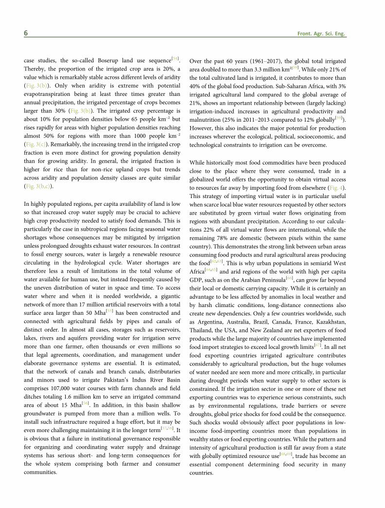
case studies, the so-called Boserup land use sequence[54].Thereby, the proportion of the irrigated crop area is 20%, avalue which is remarkably stable across different levels of aridity(Fig. 3(b)). Only when aridity is extreme with potentialevapotranspiration being at least three times greater thanannual precipitation, the irrigated percentage of crops becomeslarger than 30% (Fig. 3(b)). The irrigated crop percentage isabout 10% for population densities below 65 people km–2 butrises rapidly for areas with higher population densities reachingalmost 50% for regions with more than 1000 people km–2
(Fig. 3(c)). Remarkably, the increasing trend in the irrigated cropfraction is even more distinct for growing population densitythan for growing aridity. In general, the irrigated fraction ishigher for rice than for non-rice upland crops but trendsacross aridity and population density classes are quite similar(Fig. 3(b,c)).
In highly populated regions, per capita availability of land is lowso that increased crop water supply may be crucial to achievehigh crop productivity needed to satisfy food demands. This isparticularly the case in subtropical regions facing seasonal watershortages whose consequences may be mitigated by irrigationunless prolongued droughts exhaust water resources. In contrastto fossil energy sources, water is largely a renewable resourcecirculating in the hydrological cycle. Water shortages aretherefore less a result of limitations in the total volume ofwater available for human use, but instead frequently caused bythe uneven distribution of water in space and time. To accesswater where and when it is needed worldwide, a giganticnetwork of more than 17 million artificial reservoirs with a totalsurface area larger than 50 Mha[55] has been constructed andconnected with agricultural fields by pipes and canals ofdistinct order. In almost all cases, storages such as reservoirs,lakes, rivers and aquifers providing water for irrigation servemore than one farmer, often thousands or even millions sothat legal agreements, coordination, and management underelaborate governance systems are essential. It is estimated,that the network of canals and branch canals, distributariesand minors used to irrigate Pakistan’s Indus River Basincomprises 107,000 water courses with farm channels and fieldditches totaling 1.6 million km to serve an irrigated commandarea of about 15 Mha[56]. In addition, in this basin shallowgroundwater is pumped from more than a million wells. Toinstall such infrastructure required a huge effort, but it may beeven more challenging maintaining it in the longer term[57,58]. Itis obvious that a failure in institutional governance responsiblefor organizing and coordinating water supply and drainagesystems has serious short- and long-term consequences forthe whole system comprising both farmer and consumercommunities.
Over the past 60 years (1961–2017), the global total irrigatedarea doubled to more than 3.3 million km2[59]. While only 21% ofthe total cultivated land is irrigated, it contributes to more than40% of the global food production. Sub-Saharan Africa, with 3%irrigated agricultural land compared to the global average of21%, shows an important relationship between (largely lacking)irrigation-induced increases in agricultural productivity andmalnutrition (25% in 2011–2013 compared to 12% globally[59]).However, this also indicates the major potential for productionincreases wherever the ecological, political, socioeconomic, andtechnological constraints to irrigation can be overcome.
While historically most food commodities have been producedclose to the place where they were consumed, trade in aglobalized world offers the opportunity to obtain virtual accessto resources far away by importing food from elsewhere (Fig. 4).This strategy of importing virtual water is in particular usefulwhen scarce local blue water resources requested by other sectorsare substituted by green virtual water flows originating fromregions with abundant precipitation. According to our calcula-tions 22% of all virtual water flows are international, while theremaining 78% are domestic (between pixels within the samecountry). This demonstrates the strong link between urban areasconsuming food products and rural agricultural areas producingthe food[62,63]. This is why urban populations in semiarid WestAfrica[64,65] and arid regions of the world with high per capitaGDP, such as on the Arabian Peninsula[66], can grow far beyondtheir local or domestic carrying capacity. While it is certainly anadvantage to be less affected by anomalies in local weather andby harsh climatic conditions, long-distance connections alsocreate new dependencies. Only a few countries worldwide, suchas Argentina, Australia, Brazil, Canada, France, Kazakhstan,Thailand, the USA, and New Zealand are net exporters of foodproducts while the large majority of countries have implementedfood import strategies to exceed local growth limits[67]. In all netfood exporting countries irrigated agriculture contributesconsiderably to agricultural production, but the huge volumesof water needed are seen more and more critically, in particularduring drought periods when water supply to other sectors isconstrained. If the irrigation sector in one or more of these netexporting countries was to experience serious constraints, suchas by environmental regulations, trade barriers or severedroughts, global price shocks for food could be the consequence.Such shocks would obviously affect poor populations in low-income food-importing countries more than populations inwealthy states or food exporting countries. While the pattern andintensity of agricultural production is still far away from a statewith globally optimized resource use[68,69], trade has become anessential component determining food security in manycountries.
6 Front. Agr. Sci. Eng.
Fig. 3 Relationships between population density and per capita cropland use or cropland density (a), aridity and irrigated crop fraction (b), and
population density and irrigated crop fraction (c) derived from global data sets with a resolution of 5 arc-minutes for the year 2000. The fraction of
the harvested crop area that is irrigated (b, c) was calculated as the sum of irrigated crop area divided by the sum of the total (irrigated and
rainfed) crop area in the respective aridity or population density class.
[54]
Andreas BUERKERT et al. Social-ecological challenges to water use in human civilizations 7

Fig. 4 Aridity according to the CGIAR-CSI Global Aridity and ET database[60,61] (a ) and net virtual water flows (mm$yr–1) calculated at 5 arc-minute
resolution for North Africa, Europe and Central Asia considering 19 major food crops[62] (b). These comprise wheat, maize, rice, barley, rye, millet,
sorghum, soybeans, sunflower, potatoes, cassava, rapeseed, groundnut, pulses, citrus, dates, grapes, cocoa, and coffee. Crops used as livestock
fodder are also included in the calculations while pasture and extensive grassland is not. While grid specific production and water use was simu-
lated, per capita crop consumption was assumed constant for all grids belonging to the same country[62]. Blue indicates net virtual water out-flow(water use for local crop production bigger than virtual water content of crops consumed) and red indicates net virtual water inflow (virtual water
content in crops consumed greater than water use for crop production).Negative net virtual water flows in semiarid, arid and hyperarid regions
often indicate irrigated crop production while positive net virtual water flows show sinks (highly populated regions such as urban spaces and for
regions in which crop production is not possible because of climatic constraints). At the global scale, 22% of the virtual water fluxes occur betweenand 78% within nations.
8 Front. Agr. Sci. Eng.
4 COMPETING CLAIMS: AGRICUL-TURAL VERSUS URBAN WATER NEEDS
Globally, the expansion of irrigated areas over the last centuryhas led to a rapid increase in the annual irrigation waterwithdrawal from 590 to about 3000 km3[70] resulting in an everaggravating competition for water resources. This conflict isbecoming particularly obvious in the Middle East (Israel-Palestine-Jordan-Syria) and Central Asia (Mongolia-China),and in the several-decades-old international tensions amongChina, India, and Pakistan, for the control of Asia’s biggest riversoriginating in the Himalaya-Karakoram-Hindukush region.
Recent major water crises in the Los Angeles area of California(USA) and in Cape Town (South Africa) were only the firstalarm bells for increasing water conflicts between rural andurban needs. They illustrate that humankind is running out oftime to implement effective water saving policies and adaptationstrategies thus creating awareness among the urban populace toreduce per capita consumption of fresh water[71–75].
Such conflicts are often overlooked in developing countrieswhere trajectories of urban growth are rarely guided by a long-term plan nor do they address the supply potential of waterresources. Bangalore (Karnataka, southern India) is a particu-larly pertinent example. Situated at 920 m on a granite plateau itis one of the very few cities in South-east Asian monsoon-driven,semiarid climates that has no permanent rivers nearby. In 1537,when the city was established from a tiny thirteenth centuryvillage by the famous Hiriya Kempe Gowda I, a feudal king of theVijayanagara Empire, drinking water requirements were metfrom lakes and artificial tanks established within the territories ofthe then small town[76,77]. This continued for over a century as itgrew under diverse rulers before it came under the reign ofWodeyars of Mysore during the seventeenth century and thenunder the administrative control of the Maharaja of Mysoreduring the end of the eighteenth century. Following this, waterdemand for the city was externalized to a huge reservoir built in1933, about 35 km away from the city. However, unplanneddevelopmental activities in its catchment area reduced thereservoir’s capacity and polluted its water to such a level that itsoriginal purpose is almost defunct. Inevitably, the externaliza-tion of water supply to the exponentially growing city wasextended to the far-off Kaveri-Arkavathi river system. However,the pace of planning and execution to pump Kaveri water indifferent phases has not been able to keep up with the rapidgrowth. Importantly, filling in of tanks and lakes for construc-tion, sedimentation, and blockage of natural drainage in and
around the city area have contributed to the shrinking oflakes[78] and so did overall declining surface water sources foragriculture that met urban needs for perishable goods. As a resultof a typical red loop situation[79], for the past 50 years much ofthe drinking and irrigation water for agriculture, global flowerproduction, and beautification of the city has been drawn fromdeep tube wells. Given political constraints, records from thesewells are sketchy. However, recent data on well depth indicate arapid fall of the water table in the Arkavathi Basin of Bengaluruto more than 400 m[80]. This has led Bangalore authorities todiscourage paddy rice production in Greater Bengaluru follow-ing thus the example of China where paddy cultivation isrestricted to a distance of 100 km from any major town.Currently, milking cattle, which are of high cultural valuethroughout India, can still be kept in large numbers in Bengaluruenhancing agricultural water use for cooling and unfilteredmanure flushing into sewers[81] which ultimately contributes tocontamination of entire aquifers[82]. In India, the water crisis isprobably the most sensitive national political issue for the nextdecade, comparable only to the discourse with Pakistan aboutjoint security.
5 CONCLUSIONS
Given the increasingly evident climate change effects on humanlivelihoods, the numerous examples of access to and power overwater determining the rise and fall of cities or entire civilizationsthroughout human history underline the need for moreelaborate systems of water governance. Rapid rural-urbantransformations leading to increasing shares of populationsliving in cities and relying on water for direct and indirecthuman needs will aggravate the pressure to regulate waterutilization. While international food trade is one way to lessenthe obvious agricultural dependence on access to water byexternalization, it increases a country’s susceptibility to politicalpressure. Sustainable food trade therefore requires reliableinternational structures and agreements to avoid importersbecoming captive to arbitrary political decisions made far away.In particular, in and around cities, recycling and reuse of waterwill become an increasingly urgent task, but it requires strictenforcement of, and adherence to, laws that emphasize closednutrient and waste cycles as well as use of effective technologiesof water purification. With increasing densification and risingwater use, particularly in poorer countries with temporary aridclimates with so far low water consumption per capita, the nexusbetween availability of, and access to, high quality water andsocietal peace is likely to become the single most noticeablechallenge for this century.
Andreas BUERKERT et al. Social-ecological challenges to water use in human civilizations 9

Acknowledgements
This study was conducted in the framework of the Indo-German Research Unit FOR2432/1&2 “Social-ecological systems in the Indianrural-urban interface: Functions, scales, and dynamics of transitions” funded by the German Science Foundation (DFG, BU1308/13-1&2)and the Department of Biotechnology (DBT), Government of India. SS acknowledges support of the project GlobeDrought(02WGR1457F) by the German Federal Ministry of Education and Research (BMBF) through its Global Resource Water (GRoW) fundinginitiative. KNG thanks the Universität Kassel, Germany for travel funding enabling a visit as a guest lecturer through the university’sDAAD-financed International Center for Development and Decent Work (ICDD).
Compliance with ethics guidelines
Andreas Buerkert, Kotiganahalli Narayanagowda Ganeshaiah, and Stefan Siebert declare that they have no conflicts of interest or financialconflicts to disclose. This article does not contain any studies with human or animal subjects performed by any of the authors.
REFERENCES1. Rito T, Vieira D, Silva M, Conde-Sousa E, Pereira L, Mellars P,
Richards M B, Soares P. A dispersal of Homo sapiens fromsouthern to eastern Africa immediately preceded the out-of-Africa migration. Scientific Reports, 2019, 9(1): 4728
2. Gates C. Ancient Cities: the Archaeology of Urban Life in theAncient Near East and Egypt, Greece and Rome. Abingdon,United Kingdom: Routledge, Taylor and Francis, 2003, 18
3. Helms S W. Jawa: Lost City of the Black Desert. Ithaka, NY,USA: Cornell University Press, 1981
4. Müller-Neuhof B. The gardens of Jawa: early evidence forrainwater harvesting irrigation. Bulletin of the Council of BritishResearch in the Levant, 2012, 7: 62–64
5. Müller-Neuhof B. Desert irrigation agriculture—evidence forEarly Bronze Age rainwater-harvesting irrigation agriculture atJawa (NE-Jordan). In: D. Morandi Bonacossi, ed. SettlementDynamics and Human Landscape Interaction in the Steppes andDeserts of Syria. Wiesbaden, Germany: Studia Chaburensia 4.Harrassowitz Verlag, 2014, 187–197
6. Oleson J P. The Oxford Handbook of Engineering andTechnology in the Classical World. Oxford, England: OxfordUniversity Press, 2008, 896 ISBN: 9780199734856
7. Hansen D R. Karez (Qanats) of Turpan, China, 1999. Availableat WaterHistory website on May 18, 2019
8. Snelgrove A K. Migrations of the Indus river, Pakistan inresponse to plate tectonic motions. Journal of the GeologicalSociety of India, 1979, 20(3): 352–403
9. Giosan L, Orsi W D, Coolen M, Wuchter C, Dunlea A G,Thirumalai K, Munoz S E, Clift P D, Donnelly J P, Galy V, FullerD Q. Neological climate anomalies and the Harppan metamor-phosis. Climate of the Past, 2018, 14(11): 1669–1686
10. Green A S, Petrie C A. Landscapes of urbanization and de-urbanization: a large-scale approach to investigating the Induscivilization’s settlement distributions in Northwest India.Journal of Field Archaeology, 2018, 43(4): 284–299
11. Kovach R L, Grijalva K, Nur A. Earthquakes and civilizations ofthe Indus Valley: a challenge for archaeoseismology. GeologicalSociety of America, 2010, 471: 119–127
12. Grijalva K A, Kovach R L, Nur A M. Evidence for TectonicActivity During the Mature Harappan Civilization, 2600–1800BCE. Fall Meeting: American Geophysical Union, 2006
13. Lal R, Saini H S, Pant N C, Mujtaba S A I. Tectonics inducedswitching of provenance during the Late Quaternary aggrada-tion of the Indus River Valley, Ladakh, India. GeoscienceFrontiers, 2019, 10(1): 285–297
14. Wilkinson J C. Water and Tribal Settlement in South-EastArabia: A Study of the Aflaj of Oman. London, England: OxfordUniversity Press, 1977, 276
15. Buerkert A, Schlecht E. Oases of Oman—livelihood systems atthe crossroads. Muscat, Oman: Al Roya Press & PublishingHouse, 2010, 138 ISBN 978–9948–15–510–2
16. Nagieb M, Siebert S, Luedeling E, Buerkert A, Häser J.Settlement history of a mountain oasis in northern Oman—evi-dence from land use and archaeological studies. Die Erde, 2004,135(1): 81–106
17. Kennett D J, Breitenbach S F, Aquino V V, Asmerom Y, Awe J,Baldini J U, Bartlein P, Culleton B J, Ebert C, Jazwa C, Macri M J,Marwan N, Polyak V, Prufer K M, Ridley H E, Sodemann H,Winterhalder B, Haug G H. Development and disintegration ofMaya political systems in response to climate change. Science,2012, 338(6108): 788–791
18. Hoggarth J A, Breitenbach S F M, Culleton B J, Ebert C E,Masson M A, Kennett D J. The political collapse of Chichén Itzáin climatic and cultural context. Global and Planetary Change,2016, 138: 25–42
19. Adams R E W, Brown W E Jr, Culbert T P. Radar mapping,archeology, and ancient maya land use. Science New Series, 1981,213(4515): 1457–1468
20. Clynes T. Laser scans reveal Maya “Megalopolis” below
10 Front. Agr. Sci. Eng.
Guatemalan jungle. National Geographic, 1 February 2018.Available at NATIONAL GEOGRAPHIC website on May 16,2019
21. De Anda Alanís G. Sacrifice and Ritual Body Mutilation inPostclassical Maya Society: Taphonomy of the Human Remainsfrom Chichén Itzá's Cenote Sagrado”. In: Tiesler V, Cucina A,eds. New Perspectives on Human Sacrifice and Ritual BodyTreatments in Ancient Maya Society. Interdisciplinary Con-tributions to Archaeology. New York, USA: Springer, 2007, 190–208
22. Carter B P. Technology, Society and Change: Shell ArtifactProduction Among the Manteno (AD 800–1532) of CoastalEcuador. Dissertation for the Doctoral Degree. Seattle, USA:University of Washington, 2008
23. Erickson C L. Raised field agriculture in the Lake TiticacaBasin—putting ancient agriculture back to work. Expedition,1988, 30(1): 8–16
24. Hanson J W, Ortman S G, Lobo J. Urbanism and the division oflabour in the Roman Empire. Journal of the Royal SocietyInterface, 2017, 14(136): 20170367
25. Butzer K W. Early Hydraulic Civilization in Egypt: A Study inCultural Ecology (Prehistoric Archaeology and Ecology).Chicago: The University of Chicago Press, 1976
26. Van Dyke P A. How and why the Dutch East India Companybecame competitive in Intra-Asian Trade in East Asia in the1630s. Itinerario, 1997, 21(3): 41–56
27. Ogborn M. Spaces of Modernity: London’s Geographies, 1680–1780. New York: Guilford Press, 1998, 206
28. Glavan M, Schmutz U, Williams S, Corsi S, Monaco F, KneafseyM, Guzman Rodriguez P A, Čenič-Istenič M, Pintar M. Theeconomic performance of urban gardening in three Europeancities—examples from Ljubljana, Milan and London. UrbanForestry & Urban Greening, 2018, 36: 100–122
29. Ganeshaiah K N. The Thalakaadu phenomenon: a miracle or anecological disaster? Current Science, 2007, 93(11): 1495–1500
30. Roy A B, Sethumadav M S. The ‘mystic’ sand dune-coveredtemples of Talakad, Mysoredistrict, Karnataka: evidence ofearthquake-related destruction. Current Science, 2014, 107(2):246–254
31. Srikantia S V, Anantharamu T R. The Talkad sand dunes inMysore District of Karnataka—their description, evolution andorigin. Journal of the Geological Society of India, 1997, 50: 315–321
32. Grove R H. The Great El Niño of 1789–93 and its globalconsequences: reconstructing an extreme climate event in worldenvironmental history.Medieval History Journal, 2006, 10(1–2):75–98
33. Penny D, Pottier C, KummuM, Fletcher R, Zoppi U, Barbetti M,Somaneath T. Hydrological history of the West Baray, Angkor,revealed through palynological analysis of sediments from theWest Mebon. Bulletin de l’Ecole Francaise d’Extreme-Orient,2005, 92(1): 497–521
34. Fletcher R, Penny D, Evans D, Pottier C, Barbetti M, KummuM,
Lustig T. The water management network of Angkor,Cambodia. Antiquity, 2008, 82(317): 658–670
35. Fletcher R, Pottier C, Johnson W. Authority for the Protectionand Management of Angkor and the Region of Siem Reap.Masonry Water Management Structures in Angkor: Structureand Significance. In: Pautreau J P, Coupey A S, Zeitoun V,Rambault E, eds. From Homo erectus to the Living Traditions.Bougon: European Association of Southeast Asian Archaeolo-gists, 2008, 231–237
36. Buckley B M, Anchukaitis K J, Penny D, Fletcher R, Cook E R,Sano M, Nam C, Wichienkeeo A, Minh T T, Hong T M. Climateas a contributing factor in the demise of Angkor, Cambodia.Proceedings of the National Academy of Sciences of the UnitedStates of America, 2010, 107(15): 6748–6752
37. Pal S. Modern India can learn a lot from these 20 traditionalwater conservation systems. 2016. Available at The Better Indiawebsite on April 1, 2020
38. Lorenzi R. Earliest depiction of ‘Fiery Serpent’ found inMedieval painting. 2017. Available at Live Science website onApril 1, 2020
39. Shankari U. Tanks: major problems in minor irrigation.Economic and Political Weekly, 1991, 26(39): A115–A125
40. Shankari U, Shah E. Water Management Traditions in India.Chennai, India: PPST Foundation, 1993
41. Mukundan TM. Ery System of South India.Waterline, 1998, 10:16. Revised and reprinted by Akash Ganga Trust Chennai in2005. Available at Samanvaya website on January 11, 2020
42. Shah E. Social Designs: Tank Irrigation Technology andAgrarian Transformation in Karnataka, South India. Wagenin-gen, the Netherlands: Wageningen University, 2003
43. Shah E. Telling otherwise: a historical anthropology of tankirrigation technology in South India. Technology and Culture,2008, 49(3): 652–674
44. Orlove B S, Chiang J C H, Cane M A. Forecasting Andeanrainfall and crop yield from the influence of El Nino on Pleiadesvisibility. Nature, 2000, 403(6765): 68–71
45. Kanani P R. Testing of traditional methods of weatherforecasting in Gujarat using the participatory approach. In:Balasubramanian A V, Nirmala Devi T D. Traditional Knowl-edge systems of India and Sri Lanka, Papers presented at theCOMPAS Asian Regional Workshop on Traditional KnowledgeSystems and their Current Relevance and Applications.Chennai, India: Centre for Indian Knowledge Systems, 2006
46. Geertz C. Agricultural Involution: the Processes of EcologicalChange in Indonesia. Berkeley and Los Angeles: University ofCalifornia Press, 1963
47. Boserup E. The conditions of agricultural growth: the economicsof agrarian change under population pressure. England: Taylor& Francis Group, 1993
48. Bernal V. Colonial moral economy and the discipline ofdevelopment: the Gezira Scheme and “Modern” Sudan. CulturalAnthropology, 1997, 12(4): 447–479
49. Sarkar A, Sen S, Kumar A. Rice-wheat cropping cycle in Punjab:
Andreas BUERKERT et al. Social-ecological challenges to water use in human civilizations 11

a comparative analysis of sustainability status in differentirrigation systems. Environment, Development and Sustainabil-ity, 2009, 11(4): 751–763
50. Hall R. Land Grabbing in Africa and the New Politics of Food.Policy Brief 041. Available at Future Agricultures website onDecember 24, 2019
51. NASA Socioeconomic Data and Applications Center (SEDAC).Gridded Population of theWorld (GPW), V3. Population CountGrid, v3 (1990, 1995, 2000). Available at SEDAC website onDecember 24, 2019 doi: 10.7927/H4639MPP
52. International Insititure for Applied Systems Analysis (IIASA).Global Agro-ecological Zones (GAEZ v3.0)-Model Documenta-tion. 2012. Available at IIASA website on December 24, 2019
53. Portmann F T, Siebert S, Döll P. MIRCA2000-Global monthlyirrigated and rainfed crop areas around the year 2000: a newhigh-resolution data set for agricultural and hydrologicalmodeling. Global Biogeochemical Cycles, 2010, 24(1): Gb1011
54. Ruddiman W F, Ellis E C. Effect of per-capita land use changeson Holocene forest clearance and CO2 emissions. QuaternaryScience Reviews, 2009, 28(27–28): 3011–3015
55. Lehner B, Reidy Liermann C, Revenga C, Vörösmarty C, FeketeB, Crouzet P, Döll P, Endejan M, Frenken K, Magome J, NilssonC, Robertson J C, Rödel R, Sindorf N, Wisser D. High-resolutionmapping of the world’s reservoirs and dams for sustainableriver-flow management. Frontiers in Ecology and the Environ-ment, 2011, 9(9): 494–502
56. Food and Agriculture Organization of the United Nations(FAO). Irrigation in Southern and Eastern Asia in figures. Rome:FAO, 2012. Available at FAO website on December 24, 2019
57. Chaudhry M A, Ali M. Measuring benefits to operation andmaintenance expenditure in the canal irrigation system ofPakistan: a simulation analysis. Agricultural Economics, 1989, 3(3): 199–212
58. Food and Agriculture Organization of the United Nations(FAO). Realizing the value of irrigation system maintenance.Rome: FAO, 1999. Available at FAO website on December 24,2019
59. Food and Agriculture Organization of the United Nations(FAO). FAOSTAT. Available at FAO website on November 2,2019
60. CGIAR-CSI. Global Aridity and PET Database. Washington:CGIAR-CSI, 2014. Available at CGIAR-CSI website on May 30,2019
61. Zorner R J, Trabucco A, Bossio D A, Verchot L V. Climatechange mitigation: a spatial analysis of global land suitability forclean development mechanism afforestation and reforestation.Agriculture, Ecosystems & Environment, 2008, 126(1–2): 67–80
62. Hoff H, Döll P, Fader M, Gerten D, Hauser S, Siebert S. Waterfootprints of cities—indicators for sustainable consumption andproduction. Hydrology and Earth System Sciences, 2014, 18(1):213–226
63. Hoekstra A Y, Mekonnen M M. The water footprint ofhumanity. Proceedings of the National Academy of Sciences ofthe United States of America, 2012, 109(9): 3232–3237
64. Karg H, Drechsel P, Akoto-Danso E K, Glaser R, Nyarko G,Buerkert A. Foodsheds and city region food systems in twoWest-African cities. Sustainability, 2016, 8(12): 1175
65. Akoto-Danso E K, Karg H, Drechsel P, Nyarko G, Buerkert A.Virtual water flow in food trade systems of two West Africancities. Agricultural Water Management, 2019, 213: 760–772
66. Oki T, Yano S, Hanasaki N. Economic aspects of virtual watertrade. Environmental Research Letters, 2017, 12(4): 044002
67. Porkka M, Kummu M, Siebert S, Varis O. From foodinsufficiency towards trade dependency: a historical analysis ofglobal food availability. PLoS One, 2013, 8(12): e82714
68. Davis K F, Rulli M C, Seveso A, D’Odorico P. Increased foodproduction and reduced water use through optimized cropdistribution. Nature Geoscience, 2017, 10(12): 919–924
69. Mueller N D, Gerber J S, Johnston M, Ray D K, Ramankutty N,Foley J A. Closing yield gaps through nutrient and watermanagement. Nature, 2012, 490(7419): 254–257
70. Wisser D, Fekete B M, Vörösmarty C J, Schumann A H.Reconstructing 20th century global hydrography: a contributionto the Global Terrestrial Network-Hydrology (GTN-H).Hydrology and Earth System Sciences, 2010, 14(1): 1–24
71. Hanak E, Mount J, Chappelle C. California’s Latest Drought.PPIC Water Policy Center. San Francisco, USA: Public PolicyInstitute of California, 2016
72. Simon Wang S Y, Yoon J H, Gillies R R, Hsu H H. TheCalifornia Drought: Trends and Impacts. In: Wang S, Yoon J H,Funk C C, Gillies R R, eds. Climate Extremes: Patterns andMechanisms. Hoboken, USA: The American Geophysical Union;Wiley & Sons, 2017
73. Tortajada C, Kastner M J, Buurman J, Biswas A K. TheCalifornia drought: coping responses and resilience building.Environmental Science & Policy, 2017, 78: 97–113
74. Muller M. Cape Town’s drought: don’t blame climate change.Nature, 2018, 559(7713): 174–176
75. Ziervogel G. Unpacking the Cape Town drought: Lessonslearned. University of Cape Town. South Africa: Resilience andWater Governance. Rodebosch: African Centre for Cities, 2019doi: 10.13140/RG.2.2.36540.69760
76. Sudhira H S, Nagendra H. Local Assessment of Bangalore:Graying and Greening in Bangalore—Impacts of Urbanizationon Ecosystems, Ecosystem Services and Biodiversity. In:Elmqvist T, Fragkias M, Goodness J, Güneralp B, MarcotullioP J, McDonald R I, Parnell S, Schewenius M, Sendstad M, Seto KC, Wilkinson C, eds. Urbanization, Biodiversity and EcosystemServices: Challenges and Opportunities: A Global Assessment.Dordrecht, the Netherlands: Springer, 2013, 75–91
77. Vokkaligara Parishat of America (VPA). Narayana R, KempeGowdas of Bengalooru (Bangalore). Available at VPA website onJanuary 11, 2020
78. Brinkmann K, Hoffmann E, Buerkert A. Spatial and temporaldynamics of urban wetlands along a rural-urban gradient in anIndian megacity over the past 53 years. Remote Sensing, 2020, 12(4): 662
79. Cumming G S, Buerkert A, Hoffmann E M, Schlecht E, von
12 Front. Agr. Sci. Eng.

Cramon-Taubadel S, Tscharntke T. Implications of agriculturaltransitions and urbanization for ecosystem services. Nature,2014, 515(7525): 50–57
80. Srinivasan V, Thompson S, Madhyastha K, Penny G, JeremiahK, Lele S. Why is the Arkavathy River drying? A multiple-hypothesis approach in a data-scarce region. Hydrology andEarth System Sciences, 2015, 19(4): 1905–1917
81. Prasad C S, Anandan S, Gowda N K S, Schlecht E, Buerkert A.Managing nutrient flows in Indian urban and peri-urbanlivestock systems. Nutrient Cycling in Agroecosystems, 2019,115(2): 159–172
82. Parvathi K S, Kumar S P, Kumar Gupta V. Evaluation of waterquality in Bellandur Lake. International Journal of EngineeringTechnology Science and Research, 2018, 5(1): 1758–1762
Andreas BUERKERT et al. Social-ecological challenges to water use in human civilizations 13