water sharing plan for the nsw great artesian basin · (6) the high priority groundwater-dependent...
TRANSCRIPT
Water Sharing Plan for the NSW Great Artesian Basin Groundwater Sources 2020
Page 1
New South Wales
Water Sharing Plan for the NSW Great Artesian Basin Groundwater Sources 2020
under the
Water Management Act 2000
I, Melinda Pavey, the Minister for Water, Property and Housing do, by this Order, in pursuance of section 50 of the Water Management Act 2000, make the following Minister’s plan, being the Water Sharing Plan for the NSW Great Artesian Basin Groundwater Sources 2020. Dated this day of 2020.
Minister for Water, Property and Housing
Explanatory note
This Plan replaces the Water Sharing Plan for the NSW Great Artesian Basin Groundwater Sources 2008.
This Order is made under section 50 of the Water Management Act 2000. The concurrence of the Minister for Energy and Environment was obtained prior to the making of this Plan.
Water Sharing Plan for the NSW Great Artesian Basin Groundwater Sources 2020
Page 2
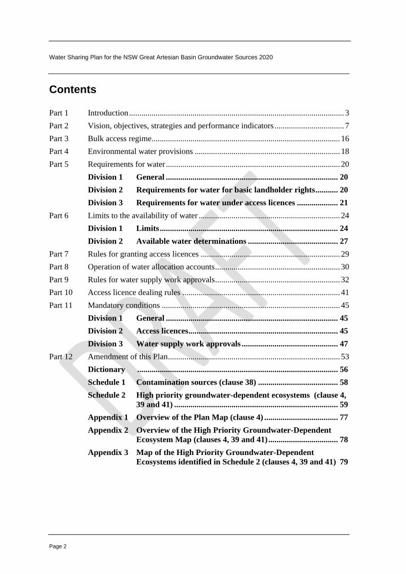
Contents Part 1 Introduction ......................................................................................................... 3
Part 2 Vision, objectives, strategies and performance indicators .................................. 7
Part 3 Bulk access regime............................................................................................ 16
Part 4 Environmental water provisions ....................................................................... 18
Part 5 Requirements for water ..................................................................................... 20
Division 1 General .................................................................................... 20
Division 2 Requirements for water for basic landholder rights ........... 20
Division 3 Requirements for water under access licences .................... 21
Part 6 Limits to the availability of water ..................................................................... 24
Division 1 Limits ....................................................................................... 24
Division 2 Available water determinations ............................................ 27
Part 7 Rules for granting access licences .................................................................... 29
Part 8 Operation of water allocation accounts ............................................................. 30
Part 9 Rules for water supply work approvals ............................................................. 32
Part 10 Access licence dealing rules ............................................................................. 41
Part 11 Mandatory conditions ....................................................................................... 45
Division 1 General .................................................................................... 45
Division 2 Access licences ......................................................................... 45
Division 3 Water supply work approvals ............................................... 47
Part 12 Amendment of this Plan .................................................................................... 53
Dictionary .................................................................................................. 56
Schedule 1 Contamination sources (clause 38) ....................................... 58
Schedule 2 High priority groundwater-dependent ecosystems (clause 4,
39 and 41) ................................................................................ 59
Appendix 1 Overview of the Plan Map (clause 4) .................................... 77
Appendix 2 Overview of the High Priority Groundwater-Dependent
Ecosystem Map (clauses 4, 39 and 41) .................................. 78
Appendix 3 Map of the High Priority Groundwater-Dependent
Ecosystems identified in Schedule 2 (clauses 4, 39 and 41) 79

Water Sharing Plan for the NSW Great Artesian Basin Groundwater Sources 2020
Page 3
Water Sharing Plan for the NSW Great Artesian Basin Groundwater Sources 2020 Notes.
1 In accordance with section 48 of the Water Management Act 2000, the Minister is to take all reasonable steps to give effect to the provisions of this Plan when exercising functions under the Act.
2 In accordance with section 49 of the Water Management Act 2000, public authorities must also have regard to the provisions of this Plan to the extent they apply to the public authority.
3 The Minister may amend this Plan at any time under section 45 of the Water Management Act 2000, including if satisfied it is in the public interest to do so, or in such circumstances, in relation to such matters and to such extent as Part 12 provides.
Part 1 Introduction
1 Name of Plan
This Plan is the Water Sharing Plan for the NSW Great Artesian Basin Groundwater
Sources 2020 (this Plan).
2 Nature and status of Plan
(1) This Plan is made under section 50 of the Water Management Act 2000 (the Act).
(2) This Plan is a plan for water sharing and generally deals with the matters set out in
sections 20 and 21 of the Act, as well as other sections of the Act.
Note. Where a provision of this Plan is made for the purposes of another section of the Act, the section is referred to in the notes to this Plan.
3 Commencement
This Plan commences on 1 July 2020.
Notes.
1 This Plan replaces the Water Sharing Plan for the NSW Great Artesian Basin Groundwater Sources 2008.
2 In accordance with section 43 of the Act, this Plan will have effect for 10 years from 1 July 2020. In accordance with section 43A of the Act, the Minister may extend this Plan for a further period of 10 years after it is due to expire.
4 Application of Plan
(1) This Plan applies to the following water sources known as the NSW Great Artesian
Basin Groundwater Sources within the Border Rivers Water Management Area,
Gwydir Water Management Area, Namoi Water Management Area, Central West
Water Management Area and Western Water Management Area (the groundwater
sources):

Water Sharing Plan for the NSW Great Artesian Basin Groundwater Sources 2020
Page 4
(a) the Central Groundwater Source,
(b) the Eastern Recharge Groundwater Source,
(c) the Southern Recharge Groundwater Source,
(d) the Surat Groundwater Source,
(e) the Warrego Groundwater Source.
Note. The Border Rivers Water Management Area, Gwydir Water Management Area, Namoi Water Management Area, Central West Water Management Area and Western Water Management Area were constituted by Ministerial order made under section 11 of the Act and published in the NSW Government Gazette No 180 on 23 November 2001 at page 9389.
(2) The boundaries of the groundwater sources are shown on the Plan Map
(WSP040_Version 2) Water Sharing Plan for the NSW Great Artesian Basin
Groundwater Sources 2020 (the Plan Map), held by the Department.
Notes.
1 The Plan Map shows the extent of the groundwater sources. The extent of the groundwater sources below the surface of the ground is described in subclauses (3) – (5).
2 The Plan Map is part of this Plan and is available on the NSW legislation website. An overview of the Plan Map is shown in Appendix 1.
(3) Subject to subclause (5), the waters in the Southern Recharge Groundwater Source
and the Eastern Recharge Groundwater Source comprise all water contained within:
(a) all rocks of Cretaceous, Jurassic and Tertiary age, and
(b) all unconsolidated alluvial sediments below the surface of the ground
within the boundaries of the Southern Recharge Groundwater Source and the Eastern
Recharge Groundwater Source shown on the Plan Map.
Note. Unconsolidated alluvial sediments is defined in the Dictionary.
(4) Subject to subclause (5), the waters in the Surat Groundwater Source, the Warrego
Groundwater Source and the Central Groundwater Source comprise all water
contained within all rocks of Cretaceous and Jurassic age at a depth of more than 60
metres below the ground level within boundaries of the Surat Groundwater Source,
the Warrego Groundwater Source and the Central Groundwater Source shown on the
Plan Map.
(5) The groundwater sources do not include any water contained in the following:
(a) the water sources to which the Water Sharing Plan for the Darling Alluvial
Groundwater Sources 2020 applies,
Water Sharing Plan for the NSW Great Artesian Basin Groundwater Sources 2020
Page 5
(b) the water sources to which the Water Sharing Plan for the Gwydir Alluvial
Groundwater Sources 2020 applies,
(c) the water sources to which the Water Sharing Plan for the Macquarie-
Castlereagh Groundwater Sources 2020 applies,
(d) the water sources to which the Water Sharing Plan for the Namoi Alluvial
Groundwater Sources 2020 applies,
(e) the water sources to which the Water Sharing Plan for the NSW Border Rivers
Alluvial Groundwater Sources 2020 applies,
(f) the water sources to which the Water Sharing Plan for the NSW Great Artesian
Basin Shallow Groundwater Sources 2020 applies,
(g) the water sources to which the Water Sharing Plan for the NSW Murray
Darling Basin Fractured Rock Groundwater Sources 2020 applies,
(h) the water sources to which the Water Sharing Plan for the NSW Murray
Darling Basin Porous Rock Groundwater Sources 2020 applies.
(6) The high priority groundwater-dependent ecosystems for the purposes of this Plan are:
(a) shown on the High Priority Groundwater-Dependent Ecosystem Map
(GDE025_Version 1), Water Sharing Plan for the NSW Great Artesian Basin
Groundwater Sources 2020 (the High Priority Groundwater-Dependent
Ecosystem Map), held by the Department, and
(b) identified in Schedule 2.
Notes.
1 Groundwater-dependent ecosystem and high priority groundwater-dependent ecosystems are defined in the Dictionary.
2 The High Priority Groundwater-Dependent Ecosystem Map is part of this Plan and is available on the NSW legislation website. An overview of the High Priority Groundwater-Dependent Ecosystem Map is shown in Appendix 2.
3 A map of the high priority groundwater-dependent ecosystems identified in Schedule 2 is shown in Appendix 3.
5 Interpretation
(1) Unless otherwise defined in this Plan, words and expressions that are defined in the
Act or in the regulations made under the Act have the same meaning in this Plan.
(2) Words and expressions that are defined in the Dictionary to this Plan have the
meaning set out in the Dictionary.

Water Sharing Plan for the NSW Great Artesian Basin Groundwater Sources 2020
Page 6
(3) Unless otherwise specified in this Plan, a clause that applies to a category of access
licence also applies to any subcategories of that category of access licence.
(4) The Dictionary and Schedules to this Plan form part of this Plan.
(5) The Plan Map and the High Priority Groundwater-Dependent Ecosystem Map form
part of this Plan.
(6) Notes in the text of this Plan do not form part of this Plan.
(7) Appendices to this Plan do not form part of this Plan.

Water Sharing Plan for the NSW Great Artesian Basin Groundwater Sources 2020
Page 7
Part 2 Vision, objectives, strategies and performance indicators
Notes.
1 This Part is made in accordance with section 35 (1) of the Act.
2 Monitoring, evaluation and reporting (MER) plans are being developed for the groundwater sources and will be available on the Department’s website. The MER plans describe the following:
(a) guidelines and principles for developing broad and targeted objectives, strategies and performance indicators,
(b) selection criteria for identifying priority monitoring locations for targeted objectives,
(c) selection criteria used to identify external influences that may affect the success of achieving objectives or implementing strategies,
(d) selection criteria used to determine how the objectives ‘to protect’ will be measured by performance indicators.
3 This Part describes broad objectives, which are the long term outcomes of this Plan and are not directly measured but evaluated by considering the cumulative achievement of the associated targeted objectives. Targeted objectives described in this Part are specific outcomes that can be achieved by the strategies in this Plan and can be directly measured so that success or failure to achieve the objective can be quantified.
6 Acknowledgement
Respect is paid to the traditional owners of this country, who are acknowledged as the
first natural resource managers within the Border Rivers Water Management Area,
Gwydir Water Management Area, Namoi Water Management Area, Central West
Water Management Area and Western Water Management Area.
7 Vision statement
The vision for this Plan is to provide for the following:
(a) the protection of the condition of the groundwater sources and their dependent
ecosystems,
(b) the continuing productive extraction of groundwater for economic benefit,
(c) the social and cultural benefits to urban and rural communities that result from
groundwater extraction,
(d) the spiritual, social, customary and economic benefits of groundwater to
Aboriginal communities.
8 Environmental objectives
(1) The broad environmental objective of this Plan is to protect the condition of the
groundwater sources and their groundwater-dependent ecosystems over the term of
this Plan.
Water Sharing Plan for the NSW Great Artesian Basin Groundwater Sources 2020
Page 8
(2) The targeted environmental objectives of this Plan are as follows:
(a) to protect the extent and condition of high priority groundwater-dependent
ecosystems,
(b) to contribute to the maintenance of salinity levels within water quality target
ranges that support high priority groundwater-dependent ecosystems,
(c) to contribute to the prevention of structural damage to an aquifer of the
groundwater sources resulting from groundwater extraction.
Note. Structural damage to an aquifer is defined in the Dictionary.
(3) The strategies for reaching the targeted environmental objectives of this Plan are as
follows:
(a) reserve all water for the environment in excess of the limits to the availability of
water,
Note. Part 4 reserves all water remaining above the long-term average annual extraction limits for the environment.
(b) manage extractions under access licences and basic landholder rights within the
limits to the availability of water,
Note. Part 6 manages extraction of groundwater within the long-term average annual extraction limits.
(c) manage the construction and use of water supply works to minimise impacts on
high priority groundwater-dependent ecosystems and groundwater quality.
Note. Part 9 sets provisions that manage the location, construction and use of water supply works to prevent impacts on high priority groundwater-dependent ecosystems and from sources of contaminated water.
(4) The performance indicator used to measure the success of the strategies for reaching
the broad environmental objective in subclause (1) is an evaluation of the extent to
which the combined outcomes of the targeted objectives in subclause (2) have
contributed to achieving the broad objective.
(5) The performance indicators used to measure the success of the strategies for reaching
the targeted environmental objectives in subclause (2) are the changes in trends in
ecological condition during the term of this Plan as assessed using one or more of the
following:
(a) the extent and recorded condition of high priority groundwater-dependent
ecosystems,

Water Sharing Plan for the NSW Great Artesian Basin Groundwater Sources 2020
Page 9
(b) the recorded condition of target populations of high priority groundwater-
dependent native vegetation,
(c) the recorded values of total dissolved solids,
Notes.
1 Total dissolved solids will be used as a measure of salinity levels.
2 Total dissolved solids is defined in the Dictionary.
(d) the recorded values of groundwater levels and pressures.
(6) In evaluating the effectiveness of the strategies in meeting the objectives in this
clause, the following will be relevant:
(a) the extent to which the strategies in subclause (3) and provisions in this Plan
have been implemented and complied with,
(b) the extent to which changes in the performance indicators can be attributed to
the strategies in subclause (3) and provisions in this Plan,
(c) the extent to which the strategies in subclause (3) support achievement of the
environmental objectives,
(d) the extent to which external influences on the groundwater sources and their
dependent ecosystems have affected progress toward achieving the
environmental objectives.
Note. External influences may include long- and short-term climate trends, land use patterns and other factors.
9 Economic objectives
(1) The broad economic objective of this Plan is to provide access to groundwater to
optimise economic benefits for groundwater-dependent businesses and local
economies.
(2) The targeted economic objectives of this Plan are as follows:
(a) to provide groundwater trading opportunities for groundwater-dependent
businesses,
Note. Trading is a generic term referring to dealings under Division 4 of Part 2 of Chapter 3 of the Act.
(b) to provide access to groundwater in the long term for groundwater-dependent
businesses,
Water Sharing Plan for the NSW Great Artesian Basin Groundwater Sources 2020
Page 10
(c) to contribute to the maintenance of groundwater salinity levels within ranges
that maintain a beneficial use category that supports groundwater-dependent
businesses.
Note. Beneficial use category is defined in the Dictionary.
(3) The strategies for reaching the targeted economic objectives of this Plan are as
follows:
(a) provide a clear framework for sharing water among water users,
Note. Part 6 provides certainty in how available water is determined and shared between individual access licence holders and different categories of access licences.
(b) where possible and subject to assessment of local impacts, provide for
flexibility of access to water and trade of water allocations and entitlements
within the groundwater sources,
Notes.
1 The account management provisions in Part 8, including those relating to the amount of water that may be carried over from one water year to the next, and the volume of water that can be taken in any water year, provide flexibility for water users.
2 The provisions in Part 10 permit a variety of dealings within environmental and resource constraints, including assignment of rights under access licences and assignment of water allocations between access licences.
(c) manage extractions to specified limits over the long term,
Note. Managing extractions to limits over the long term ensures the groundwater will be available for future beneficial economic uses.
(d) manage the construction and use of water supply works to minimise impacts on
groundwater pressures and groundwater quality.
(4) The performance indicator used to measure the success of the strategies for reaching
the broad economic objective in subclause (1) is an evaluation of the extent to which
the combined outcomes of the targeted economic objectives in subclause (2) have
contributed to achieving the broad objective.
(5) The performance indicators used to measure the success of the strategies for reaching
the targeted economic objectives in subclause (2) are the changes or trends in
economic benefits during the term of this Plan as assessed using one or more of the
following:
(a) the economic benefits of water extraction and use,
(b) the economic benefits of water trading as demonstrated by:

Water Sharing Plan for the NSW Great Artesian Basin Groundwater Sources 2020
Page 11
(i) the annual number or volume of share components of access licences
transferred or assigned, and
(ii) the weighted average unit price of share components of access licences
transferred or assigned, and
Note. Weighted average unit price is defined in the Dictionary.
(iii) the annual volume of water allocations assigned, and
(iv) the weighted average unit price of water allocations assigned,
(c) the recorded values of total dissolved solids,
(d) the recorded values of groundwater levels and pressures.
(6) In evaluating the effectiveness of the strategies in meeting the objectives in this
clause, the following will be relevant:
(a) the extent to which the strategies in subclause (3) and provisions in this Plan
have been implemented and complied with,
(b) the extent to which the changes in the economic benefits of water extraction
and use can be attributed to the strategies in subclause (3) and provisions in this
Plan,
(c) the extent to which the strategies in subclause (3) support achievement of the
economic objectives,
(d) the extent to which external influences on groundwater-dependent businesses
have affected progress towards achieving the economic objectives.
Note. External influences may include trends in urban, agricultural and industrial development, energy costs, commodity prices, interest rates, technology advances, climate and changes in industry policy or regulation.
10 Aboriginal cultural objectives
(1) The broad Aboriginal cultural objective of this Plan is to maintain the spiritual, social,
customary and economic values and uses of groundwater by Aboriginal people.
(2) The targeted Aboriginal cultural objectives of this Plan are as follows:
(a) to provide access to groundwater in the exercise of native title rights,
(b) to provide access to groundwater for Aboriginal cultural use,
(c) to protect groundwater-dependent culturally significant areas,
Note. Groundwater-dependent culturally significant area is defined in the Dictionary.
Water Sharing Plan for the NSW Great Artesian Basin Groundwater Sources 2020
Page 12
(d) to contribute to the maintenance of groundwater salinity levels within existing
ranges that support groundwater-dependent Aboriginal cultural values and uses.
(3) The strategies for reaching the targeted Aboriginal cultural objectives of this Plan are
as follows:
(a) manage access to groundwater consistently with the exercise of native title
rights,
(b) provide for groundwater associated with Aboriginal cultural values and
purposes,
Note. The provisions in Part 7 provide opportunities for Aboriginal people to access water by allowing for the granting of an aquifer access licence of the subcategory “Aboriginal cultural”.
(c) manage extractions under access licences and basic landholder rights within the
extraction limits,
Note. The provisions in Part 6 manage extraction of groundwater within the extraction limits for the groundwater sources. This helps to protect any culturally significant areas from damage associated with long-term declines in water levels.
(d) manage the construction and use of water supply works to minimise impacts on
groundwater-dependent culturally significant areas and groundwater quality.
Note. The provisions in Part 9 manage the location, construction and use of water supply works to prevent impacts on culturally significant areas and from sources of contaminated water.
(4) The performance indicator used to measure the success of the strategies for reaching
the broad Aboriginal cultural objective in subclause (1) is an evaluation of the extent
to which the combined outcomes of the targeted Aboriginal cultural objectives in
subclause (2) have contributed to achieving the broad objective.
(5) The performance indicators used to measure the success of the strategies for reaching
the targeted Aboriginal cultural objectives in subclause (2) are the changes or trends in
Aboriginal cultural benefits during the term of this Plan as assessed using one or more
of the following:
(a) the use of water by Aboriginal people, by measuring factors including:
(i) the extent to which native title rights are capable of being exercised,
consistent with any determination of native title,
(ii) the extent to which access to water has contributed to the achievement of
Aboriginal cultural outcomes,

Water Sharing Plan for the NSW Great Artesian Basin Groundwater Sources 2020
Page 13
(b) the extent to which Aboriginal people have considered the operation of this
Plan to be beneficial to meeting their needs for groundwater-dependent
Aboriginal cultural uses and values,
(c) the extent to which changes in the use of water by Aboriginal people can be
attributed to the strategies in subclause (3) and the provisions in this Plan,
(d) the recorded values of total dissolved solids,
(e) the recorded values of groundwater levels and pressures.
(6) In evaluating the effectiveness of the strategies in meeting the Aboriginal cultural
objectives in this clause, the following will be relevant:
(a) the extent to which the strategies in subclause (3) and provisions in this Plan
have been implemented and complied with,
(b) the extent to which changes in the performance indicators can be attributed to
the strategies in subclause (3) and provisions in this Plan,
(c) the extent to which the strategies in subclause (3) support achievement of the
Aboriginal cultural objectives,
(d) the extent to which external influences on the groundwater-dependent
Aboriginal cultural activities have affected progress toward achieving the
Aboriginal cultural objectives.
11 Social and cultural objectives
(1) The broad social and cultural objective of this Plan is to provide access to
groundwater to support groundwater-dependent social and cultural values.
(2) The targeted social and cultural objectives of this Plan are as follows:
(a) to provide for access to water for basic landholder rights, town water supply
and licensed domestic and stock purposes,
(b) to provide for access to water for groundwater-dependent cultural and
community purposes,
(c) to contribute to the maintenance of groundwater salinity levels within ranges
that maintain a beneficial use category that supports groundwater-dependent
community uses.
Water Sharing Plan for the NSW Great Artesian Basin Groundwater Sources 2020
Page 14
(3) The strategies for reaching the targeted social and cultural objectives of this Plan are
as follows:
(a) provide groundwater for basic landholder rights, town water supply, and for
licensed domestic and stock purposes,
Note. The provisions in Part 6 ensure that water is available for basic landholder rights, town water supply and licensed domestic and stock purposes.
(b) manage the construction and use of water supply works to minimise impacts on
basic landholder rights and town water supply,
Note. Part 9 includes provisions that manage the location, construction and use of water supply works to minimise the impacts of extraction on groundwater supplies for basic landholder rights and towns.
(c) manage the construction and use of water supply works to minimise impacts on
groundwater quality.
Note. Part 9 includes provisions that manage the location, construction and use of water supply works to prevent contamination impacts on groundwater quality.
(4) The performance indicator used to measure the success of the strategies for reaching
the broad social and cultural objective in subclause (1) is an evaluation of the extent to
which the combined outcomes of the targeted social and cultural objectives in
subclause (2) have contributed to achieving the broad objective.
(5) The performance indicators used to measure the success of the strategies for reaching
the targeted social and cultural objectives in subclause (2) are the changes or trends in
social and cultural benefits during the term of this Plan as assessed using one or more
of the following:
(a) the social and cultural uses of water during the term of this Plan, by measuring
factors including:
(i) the extent to which basic landholder rights and licensed domestic and
stock purposes have been met, and
(ii) the extent to which local water utility access licence requirements have
been met,
(b) the recorded values of total dissolved solids,
(c) the recorded values of groundwater levels and pressures.
(6) In evaluating the effectiveness of the strategies in meeting the social and cultural
objectives in this clause, the following will be relevant:

Water Sharing Plan for the NSW Great Artesian Basin Groundwater Sources 2020
Page 15
(a) the extent to which the strategies in subclause (3) and provisions in this Plan
have been implemented and complied with,
(b) the extent to which the changes in the performance indicators can be attributed
to the strategies in subclause (3) and provisions in this Plan,
(c) the extent to which the strategies in subclause (3) support achievement of the
social and cultural objectives,
(d) the extent to which external influences on social and cultural activities
dependent on the groundwater sources during the term of this Plan have
affected progress toward achieving the social and cultural objectives.
Note. External influences may include trends in urban, agricultural and industrial development, social or cultural behaviour, climate and changes in policy or regulation.
Water Sharing Plan for the NSW Great Artesian Basin Groundwater Sources 2020
Page 16
Part 3 Bulk access regime
12 Bulk access regime
(1) This Plan establishes a bulk access regime for the extraction of water under access
licences, having regard to the following:
(a) the planned environmental water established under Part 4,
(b) the requirements for water to satisfy basic landholder rights identified under
Part 5,
(c) the requirements for water for extraction under access licences identified under
Part 5,
(d) the access licence dealing rules established under Part 10.
(2) The bulk access regime:
(a) establishes rules, according to which:
(i) access licences are to be granted as provided for in Part 7, and
(ii) available water determinations are to be made as provided for in Part 6,
and
(iii) access licences are to be managed as provided for in Part 8, and
(b) establishes rules with respect to the priorities according to which water
allocations are to be adjusted as a consequence of any reduction in the
availability of water due to an increase in extraction above the limits to the
availability of water contained in Part 6, and
(c) recognises and is consistent with the following:
(i) the limits to the availability of water as provided for in Part 6,
(ii) the water management principles under section 5 of the Act,
(iii) the effect of climatic variability on the availability of water as described
in clause 13, and
(d) contains provisions with respect to the mandatory conditions to be imposed on
access licences in Part 11.
Water Sharing Plan for the NSW Great Artesian Basin Groundwater Sources 2020
Page 17
13 Climatic variability
This Plan recognises the effects of climatic variability on groundwater levels through
provisions contained in Part 6 that manage the sharing of water within the limits of
water availability on a long-term basis.
Note. Other statutory tools are available to manage for climatic variability within a water source, for example, temporary water restrictions under section 324 of the Act.

Water Sharing Plan for the NSW Great Artesian Basin Groundwater Sources 2020
Page 18
Part 4 Environmental water provisions
Note. This Part is made in accordance with section 8 of the Act.
14 General
This Part contains environmental water provisions that commit, identify, establish and
maintain planned environmental water.
Note. In accordance with the Act, planned environmental water is water that is committed by management plans for fundamental ecosystem health or other specified environmental purposes, either generally or at specified times or in specified circumstances and that cannot, to the extent committed, be taken or used for any other purpose.
15 Commitment and identification of planned environmental water
Water is committed and identified as planned environmental water by reference to the
following:
(a) the long-term average annual commitment of water as planned environmental
water,
(b) the water that is not committed after the commitments to basic landholder rights
and for sharing and extraction under any other rights have been met.
16 Establishment and maintenance of planned environmental water
(1) Planned environmental water is established in each of the groundwater sources as
follows:
(a) the long-term average annual commitment of water as planned environmental
water, resulting from compliance with the limits to the availability of water in
accordance with the provisions specified in Part 6,
Note. Groundwater sources generally store large volumes of water that may have accumulated over thousands of years. This stored water is also replenished from time to time by rainfall, river and flood flows, and through flow from other groundwater sources. The provisions in Part 6 ensure that there will be water remaining in the groundwater sources over the long term by maintaining compliance with the long-term extraction limits. The long-term extraction limits specified in Part 6 represent a small fraction of the water in the groundwater sources. The remaining water is planned environmental water.
(b) the water remaining after water has been taken under basic landholder rights,
access licences and any other rights under the Act, and the water that cannot be
carried over from one water year to the next, in accordance with the provisions
specified in Part 6 and Part 8.
Note. The provisions in Part 8 limit the amount of water allocation in a water allocation account for an access licence that can be taken from the groundwater sources in any one water year and, if permitted by Part 8, that can be carried over from one water year

Water Sharing Plan for the NSW Great Artesian Basin Groundwater Sources 2020
Page 19
to the next water year. In addition to the water referred to in subclause (1) (a), subclause (1) (b) commits any unused water allocations that cannot be carried over for use in subsequent water years as planned environmental water.
(2) The planned environmental water established under subclause (1) is maintained by the
provisions in Part 6 and Part 8.
Note. The rules in Part 9 also provide mechanisms to ensure that no more than minimal harm will be done to high priority groundwater-dependent ecosystems, groundwater-dependent culturally significant areas, groundwater quality and groundwater levels and pressures at a local scale as a result of the granting or amending of a water supply work approval.

Water Sharing Plan for the NSW Great Artesian Basin Groundwater Sources 2020
Page 20
Part 5 Requirements for water
Division 1 General
17 Application
(1) This Part identifies the requirements for water for basic landholder rights (Division 2)
and for extraction under access licences (Division 3).
(2) The volumes of water specified in this Part represent the estimated requirements for
water to satisfy basic landholder rights and the total volumes or unit shares specified
in the share components of all access licences on commencement of this Plan.
(3) This Plan recognises that requirements for water for basic landholder rights and the
total share components of access licences may change during the term of this Plan.
Notes.
1 The total share components of access licences in the groundwater sources may change during the term of this Plan as a result of:
(a) the grant, surrender or cancellation of access licences in the groundwater sources, or
(b) the variation of local water utility licences under section 66 of the Act.
2 Basic landholder rights requirements may increase as provided for under the Act. This Plan manages changes in basic landholder rights and total share components of all access licences through provisions in Part 6 that manage the sharing of water within the limits of water availability.
3 Inherent water quality and land use activities may make the groundwater in some areas unsuitable for some purposes or uses. Groundwater should not be consumed, or otherwise used, without first being tested and, if necessary, appropriately treated to ensure it is fit for purpose. Testing and treatment is the responsibility of the water user.
Division 2 Requirements for water for basic landholder rights
Note. Under the Act, basic landholder rights are defined as domestic and stock rights, native title rights and harvestable rights. There are no harvestable rights in the groundwater sources. Under the Act, basic landholder rights authorise the take of groundwater without the need for an access licence or water use approval, although a water supply work approval is still required to construct a water bore.
18 Domestic and stock rights
On the commencement of this Plan, the water requirements of persons entitled to
domestic and stock rights are estimated to total 44,500 megalitres per year (ML/year)
and are distributed as follows:
(a) 3,800 ML/year in the Central Groundwater Source,
(b) 3,200 ML/year in the Eastern Recharge Groundwater Source,

Water Sharing Plan for the NSW Great Artesian Basin Groundwater Sources 2020
Page 21
(c) 13,500 ML/year in the Southern Recharge Groundwater Source,
(d) 20,400 ML/year in the Surat Groundwater Source,
(e) 3,600 ML/year in the Warrego Groundwater Source.
Notes.
1 Domestic and stock rights are set out in section 52 of the Act and must be exercised in accordance with any mandatory guidelines established under the Act for the taking and use of water for domestic consumption or stock watering.
2 Under section 331 of the Act, the Minister may direct the holder of a domestic and stock right to take specified measures to protect the environment, to preserve basic landholder rights or to overcome a threat to public health.
3 The volumes set out in this clause are separate from any volumes of water that may be taken under an access licence for domestic and stock purposes.
4 These water requirements represent potential demand for domestic and stock purposes, which have been estimated based on stocking rates, human population and the number of properties in the groundwater sources.
19 Native title rights
The requirement for water to satisfy native title rights is the water that may be taken in
the exercise of native title rights in accordance with the Native Title Act 1993 of the
Commonwealth, including:
(a) the native title determination for the Barkandji Traditional Owners #8 (Part A,
National Native Title Tribunal references NCD2015/001), and
(b) any other determination of native title, and
(c) any indigenous land use agreement.
Notes.
1 A map of the native title determination area can be viewed by searching the National Native Title Tribunal website at www.nntt.gov.au.
2 This Plan may be amended if there is an additional or change to a native title determination in accordance with the Native Title Act 1993 of the Commonwealth by which water is required.
3 This Plan may be amended if consultation with native title holders identifies more specific requirements for water to satisfy native title rights.
4 Native title rights may be exercised in accordance with the Native Title Act 1993 of the Commonwealth, including section 211 of that Act.
Division 3 Requirements for water under access licences
Note. This Division sets out the total volumes or unit shares in the share components of access licences in the groundwater sources at the commencement of this Plan. The actual volume of water available from year to year will depend on climate, access licence priority and the provisions in this Plan.
Water Sharing Plan for the NSW Great Artesian Basin Groundwater Sources 2020
Page 22
20 Share components of domestic and stock access licences
On the commencement of this Plan, it is estimated that the share components of
domestic and stock access licences total 32 ML/year, distributed as follows:
(a) 32 ML/year in the Eastern Recharge Groundwater Source,
(b) 0 ML/year in all other groundwater sources.
21 Share components of domestic and stock (conveyance) access licences
On the commencement of this Plan, it is estimated that the share components of
domestic and stock (conveyance) access licences total 0 ML/year.
Minister’s note.
The 2008 plan included a note advising of the introduction of a new requirement for
inefficient water distribution systems to be licensed under conveyance access licences. This
requirement has not yet been implemented. The Department is currently progressing
policy work in regard to a NSW position on ‘water tight bores’. However, this work will not
be completed in time for the finalisation of this replacement plan.
Therefore, Part 12 includes a provision that allows future amendment of this Plan to
facilitate the roll out of these licences.
22 Share components of local water utility access licences
On the commencement of this Plan, it is estimated that the share components of local
water utility access licences total 6,736 ML/year, distributed as follows:
(a) 25 ML/year in the Central Groundwater Source,
(b) 0 ML/year in the Eastern Recharge Groundwater Source,
(c) 3,066 ML/year in the Southern Recharge Groundwater Source,
(d) 3,393 ML/year in the Surat Groundwater Source,
(e) 252 ML/year in the Warrego Groundwater Source.
23 Share components of aquifer access licences
On the commencement of this Plan, it is estimated that the share components of
aquifer access licences total 65,412 unit shares, distributed as follows:
(a) 43 unit shares in the Central Groundwater Source,
(b) 34,974 unit shares in the Eastern Recharge Groundwater Source,

Water Sharing Plan for the NSW Great Artesian Basin Groundwater Sources 2020
Page 23
(c) 24,462 unit shares in the Southern Recharge Groundwater Source,
(d) 5,527 unit shares in the Surat Groundwater Source,
(e) 406 unit shares in the Warrego Groundwater Source.

Water Sharing Plan for the NSW Great Artesian Basin Groundwater Sources 2020
Page 24
Part 6 Limits to the availability of water
Division 1 Limits
24 Long-term average annual extraction limits
(1) The long-term average annual extraction limit for the Central Groundwater Source is
the sum of the following:
(a) 5,193 ML/year, plus
(b) the volume of water that is used to convey water through inefficient water
distribution systems to deliver domestic and stock rights, as determined by the
Minister, plus
(c) 30% of the water savings made under cap and pipe projects undertaken after the
commencement of this Plan, as determined by the Minister.
Notes.
1 Cap and pipe projects is defined in the Dictionary.
2 The volume in subclause (a) represents the basic landholder rights requirements in the groundwater source specified in Division 2 of Part 5, plus the licensed entitlements that existed in 2008, plus 30% of the water savings made under cap and pipe projects from 1999 to the commencement of this Plan.
3 The water accounted for under subclause (b) is the uncontrolled flow from a bore that is in excess of the water physically consumed under the domestic and stock requirement. Once the bore is capped, this water will cease to be accounted for under subclause (b) and the long-term average annual extraction limit will reduce. However, the level of reduction will be equivalent to 70% of this saved water, with the remaining 30% accounted for under subclause (c).
(2) The long-term average annual extraction limit for the Eastern Recharge Groundwater
Source is 16,200 ML/year.
(3) The long-term average annual extraction limit for the Southern Recharge
Groundwater Source is 38,700 ML/year.
Minister’s note
The long term average annual extraction limits for the Eastern and Southern recharge groundwater sources have increased from those in the 2008 water sharing plan. These were previously 13,300 ML/year and 29,400 ML/year respectively.
Further analysis of recharge to these groundwater sources has been undertaken since 2008, and this work has been independently review. Estimates of recharge have increased, and this is reflected in the long term average annual extraction limits in this draft plan. Note that:
• The percentage of recharge reserved for throughflow to the neighbouring artesian groundwater sources was retained at 60%,
Water Sharing Plan for the NSW Great Artesian Basin Groundwater Sources 2020
Page 25
• The percentage of net recharge committed as environmental water was retained at 30%, and • The percentage of net recharge committed to the long-term average annual extraction limit was retained at 70%.
Your input is sought on this issue.
(4) The long-term average annual extraction limit for the Surat Groundwater Source is the
sum of the following:
(a) 43, 446 ML/year, plus
(b) the volume of water that is used to convey water through inefficient water
distribution systems to deliver domestic and stock rights, as determined by the
Minister, plus
(c) 30% of the water savings made under cap and pipe projects undertaken after the
commencement of this Plan, as determined by the Minister.
(5) The long-term average annual extraction limit for the Warrego Groundwater Source is
the sum of the following:
(a) 8,816 ML/year, plus
(b) the volume of water that is used to convey water through inefficient water
distribution systems to deliver domestic and stock rights, as determined by the
Minister, plus
(c) 30% of the water savings made under cap and pipe projects undertaken after the
commencement of this Plan, as determined by the Minister.
Minister’s note
In the 2008 water sharing plan, the extraction limits for the Central, Surat and Warrego groundwater sources provided for all forms of take existing at the start of the plan. The extraction limits have progressively reduced as discharge from flowing bores has been reduced under cap and pipe the projects. Thirty percent of the water savings from these schemes since July 1999 is included in the extraction limit with the remainder being reserved to contribute to artesian pressure recovery.
This progressive reduction in the extraction limit has resulted in it now being below the basic landholder rights requirements in the Central groundwater source and below the 2008 estimated volume of take in the Warrego groundwater source. This is primarily due to the limited data on which the original discharge estimates were made for these water sources compared to the measured savings achieved under the cap and pipe projects.
To preserve the original intent of the 2008 plan, the Department proposes to set the extraction limit at an initial volume that is the basic landholder rights requirements (assumes water is taken through an efficient water distribution system), plus the licensed entitlements in 2008, and the water savings already accounted to the extraction limit under the rules of the 2008 plan.
Water Sharing Plan for the NSW Great Artesian Basin Groundwater Sources 2020
Page 26
The Department also proposes to continue to allow thirty percent of future water savings to be included in the extraction limit with seventy percent being reserved as planned environmental water to contribute to artesian pressure recovery.
In addition, the extraction limit also includes the volume of water taken under a domestic and stock right that is used to convey water through an inefficient water distribution system. This represents the volume of water that is in excess of the volume of water actually being consumed by the user, under their basic landholder right. It is anticipated that this volume will be reduced during the life of the plan as additional bores are capped through cap and pipe projects. When works are capped and piped, water savings are made, and the extraction limit is reduced by 70% of this saving (as this water is committed to the environment).
During consultation with the Great Artesian Basin Advisory Group some members did not agree that providing for licence entitlements should be an underlying principle on which to set the extraction limit. An alternative option may be the initial extraction volume being the sum of the basic landholder rights requirements plus the water savings already accounted to the extraction limit under the rules of the 2008 plan.
Members of the Great Artesian Basin Advisory Group also suggested that a greater proportion of the savings should be reserved as planned environmental water.
Your input is sought on these issues.
25 Calculation of annual extraction
The Minister is to determine the volume of water taken during a water year for each of
the groundwater sources under the following entitlements (the annual extraction):
(a) all categories of access licences,
(b) basic landholder rights.
26 Assessment of compliance with long-term average annual extraction limits
(1) The Minister is to undertake an assessment under this clause comparing the long-term
average annual extraction limit for each of the groundwater sources against the
average of annual extraction for the preceding five water years for the respective
groundwater source.
(2) There is non-compliance with a long-term average annual extraction limit if the
average of annual extraction for a groundwater source in the preceding five water
years exceeds the long-term average annual extraction limit for that groundwater
source by 10% or more.
27 Compliance with limits
(1) If an assessment for a groundwater source under clause 26 demonstrates non-
compliance with the long-term average annual extraction limit, the Minister is to take
any one or more of the following actions in the respective groundwater source:

Water Sharing Plan for the NSW Great Artesian Basin Groundwater Sources 2020
Page 27
(a) reduce the maximum water account debit for aquifer access licences under
clause 34,
Note. Water account debit has the meaning set out in clause 34.
(b) make an available water determination for aquifer access licences in accordance
with clause 32 of less than 1 megalitre (ML) per unit share of access licence
share component.
(2) Any action under subclause (1) is to be taken to the extent the Minister considers is
necessary to return average annual extractions in the relevant groundwater source to
the long-term average annual extraction limit.
(3) If the Minister reduces a maximum water account debit under subclause (1) (a), the
Minister may increase the maximum water account debit for aquifer access licences
later in the water year, up to the limit specified in clause 34 (3).
(4) If the Minister makes a reduced available water determination pursuant to subclause
(1) (b), the Minister may make further available water determinations in the water
year up to the limit specified in clause 28 (2).
Division 2 Available water determinations
Note. When making an available water determination at the commencement of a water year, the Minister may also make known the maximum water account debit for aquifer access licences under clause 34 for that water year, as determined under Division 1 of this Part.
28 General
(1) Available water determinations are to be expressed as one of the following:
(a) for an access licence specifying the share component in ML/year— a
percentage of the share component,
(b) for an access licence specifying the share component as a number of unit
shares— ML per unit share.
(2) The sum of available water determinations made for any access licence must not
exceed the following in any water year:
(a) for an access licence specifying the share component in ML/year— 100% of the
access licence share component,
(b) for an access licence specifying the share component as a number of unit
shares— 1 ML per unit share of the access licence share component.

Water Sharing Plan for the NSW Great Artesian Basin Groundwater Sources 2020
Page 28
Note. If the Minister makes an available water determination of less than 1 ML per unit share of the access licence share component, the Minister may make further available water determinations during a water year, subject to subclause (2).
29 Available water determinations for domestic and stock access licences
Unless the Minister otherwise determines, at the commencement of each water year an
available water determination of 100% of the access licence share component is to be
made for domestic and stock access licences.
30 Available water determinations for domestic and stock (conveyance) access
licences
Unless the Minister otherwise determines, at the commencement of each water year an
available water determination of 100% of the access licence share component is to be
made for domestic and stock access (conveyance) licences.
31 Available water determinations for local water utility access licences
Unless the Minister otherwise determines, at the commencement of each water year an
available water determination of 100% of the access licence share component is to be
made for local water utility access licences.
32 Available water determinations for aquifer access licences
Unless the Minister otherwise determines, at the commencement of each water year an
available water determination of 1 ML per unit share is to be made for aquifer access
licences.

Water Sharing Plan for the NSW Great Artesian Basin Groundwater Sources 2020
Page 29
Part 7 Rules for granting access licences
Notes.
1 This Part is made in accordance with sections 61 of the Act. Section 61 of the Act provides for applications for specific purpose access licences in accordance with the regulations and the relevant water sharing plan.
2 Access licences in the groundwater sources are granted subject to mandatory conditions required to be imposed by this Plan, the regulations and the Act, and may also be subject to discretionary conditions.
33 Specific purpose access licences
(1) The Minister must not grant a specific purpose access licence unless satisfied that the
share and extraction components of the access licence are the minimum required for
the proposed use.
(2) A person may make an application for an aquifer (Aboriginal cultural) access licence
only if the share component of the proposed access licence is no greater than 10
ML/year.
(3) A person may make an application for an aquifer (Aboriginal community
development) access licence only if the share component of the proposed access
licence is no greater than 50 ML/year.
(4) A person may make an application for a domestic and stock (conveyance) access
licence for delivering water to be used for domestic consumption and stock watering
only if, in the Minister’s opinion, the water taken under the access licence is being
conveyed through an inefficient water distribution system.
(5) The Minister may only grant an aquifer (Aboriginal cultural) access licence for the
taking of water by an Aboriginal person or Aboriginal community for any personal,
domestic or communal purpose, including drinking, food preparation, washing,
manufacturing traditional artefacts, watering domestic gardens, cultural teaching,
hunting, fishing, gathering and for recreational, cultural and ceremonial purposes.
Note. Aboriginal person is defined in the Dictionary.

Water Sharing Plan for the NSW Great Artesian Basin Groundwater Sources 2020
Page 30
Part 8 Operation of water allocation accounts
Notes.
1 Section 85 of the Act provides for the keeping of water allocation accounts for access licences. The provisions in this Part restrict the water that may be taken under, or assigned from, an access licence over a specified period of time, and the unused water allocations in water allocation accounts that may be carried over from one water year to the next. These restrictions are in addition to any other limits on access licences for the taking or assignment of water. It is an offence under section 60C of the Act to take water under an access licence for which there is no or insufficient water allocation.
2 The provisions in this Part apply to the following persons:
(a) the Minister in managing water allocation accounts,
(b) the access licence holder, as required by mandatory conditions imposed on the access licence under Part 11.
34 Water allocation account debiting
(1) For the purposes of this Plan, a water account debit means any water allocation that is
taken, assigned under section 71T of the Act, or otherwise debited or withdrawn from
a water allocation account.
(2) For domestic and stock access licences, domestic and stock (conveyance) access
licences and local water utility access licences, the maximum water account debit in a
water year must not exceed the following:
(a) the sum of water allocations credited to the water allocation account for the
access licence from available water determinations in that water year,
(b) plus any water allocations assigned to the water allocation account for the
access licence under section 71T of the Act in that water year,
(c) plus any water allocations re-credited to the water allocation account for the
access licence in accordance with section 76 of the Act in that water year.
(3) For aquifer access licences, the maximum water account debit in a water year must
not exceed the following:
(a) 1.3 ML per unit share of the access licence share component,
(b) plus any water allocations assigned to the water allocation account for the
aquifer access licence under section 71T of the Act in that water year,
(c) plus any water allocations re-credited to the water allocation account for the
aquifer access licence in accordance with section 76 of the Act in that water
year.
Water Sharing Plan for the NSW Great Artesian Basin Groundwater Sources 2020
Page 31
35 Limits on carryover
(1) For a domestic and stock access licence, a domestic and stock (conveyance) access
licence or a local water utility access licence, water allocations remaining in the water
allocation account cannot be carried over from one water year to the next water year.
(2) For an aquifer access licence, water allocations remaining in the water allocation
account are to be carried over from one water year to the next water year, up to a
maximum of 0.6 ML per unit share of the access licence share component.

Water Sharing Plan for the NSW Great Artesian Basin Groundwater Sources 2020
Page 32
Part 9 Rules for water supply work approvals
Note. This Part is made in accordance with section 95 (3) of the Act.
36 General
(1) A reference in this Part to a water supply work being located within a specified
distance includes a reference to a water supply work that is proposed to be located
within a specified distance.
(2) In addition to the matters listed in section 97 (2) of the Act, the Minister must not
grant a water supply work approval unless satisfied that adequate arrangements are in
place to ensure that there will be:
(a) no more than minimal effect on the ability of a person to take water using an
existing approved water supply work and any associated access licences, and
(b) no more than minimal harm to public health and safety or to a groundwater-
dependent culturally significant area, and
(c) no more than minimal effect on groundwater levels and pressure at the border
of New South Wales and Queensland or South Australia.
(3) Subclause (2) (c) does not apply if the Minister has consulted with and considered
views of the respective state government Minister.
(4) The Minister must not amend a water supply work approval unless satisfied of the
matters listed in subclause (2) and section 97 (2) of the Act.
Notes.
New approvals
1 Division 2 of Part 3 of Chapter 3 of the Act sets out the process for applications for, and granting of, approvals.
2 Section 97 (2) of the Act provides that the Minister may only grant a water supply work approval if satisfied that adequate arrangements are in place to ensure that no more than minimal harm will be done to any water source, or its dependent ecosystems, as a consequence of the construction or use of the proposed water supply work.
3 Section 96 (b) of the Act specifies that the Minister must take into account any matters the Minister considers relevant in determining an application for a water supply work approval. Under section 92 (5), the Minister may require an applicant to provide any additional information the Minister considers relevant to determining the application. This may include, for example, hydrogeological studies, hydrogeochemical studies or ecological studies.
Amendment of approvals
4 Section 107 of the Act provides for the amendment of approvals.
Conditions of approvals
Water Sharing Plan for the NSW Great Artesian Basin Groundwater Sources 2020
Page 33
5 The Minister may grant a water supply work approval subject to conditions, as provided in sections 95 and 100 of the Act. The Minister may also, under section 102 of the Act, impose or vary conditions on a water supply work approval at any time as the Minister thinks fit. These conditions may limit the volume or rate of extraction from a water supply work.
Other limits on volumes or rates of extraction
6 The Minister may also limit the volume or rate of extraction from existing water supply works in the following ways:
(a) for all water supply works within a specified area, by an order made under section 324 of the Act,
(b) for existing water supply works used solely for domestic and stock rights and harvestable rights, by an order made under section 331 of the Act.
Provisions in this Part
7 This Part specifies provisions in addition to those in the Act about when, and how, the Minister may grant or amend a water supply work approval.
37 Rules to minimise interference between water supply works
(1) A water supply work approval must not be granted or amended in the Eastern
Recharge Groundwater Source or the Southern Recharge Groundwater Source if the
water supply work is located within 200 metres of a water supply work that is:
(a) located on another landholding and authorised to take water solely for basic
landholder rights from the same groundwater source, or
(b) located on another landholding and nominated by another access licence, other
than a local water utility access licence.
(2) A water supply work approval must not be granted or amended in the Central
Groundwater Source, the Surat Groundwater Source or the Warrego Groundwater
Source if the water supply work is located within 500 metres of a water supply work
that is:
(a) located on another landholding and authorised to take water solely for basic
landholder rights from the same groundwater source, or
(b) located on another landholding and nominated by another access licence, other
than a local water utility access licence.
(3) A water supply work approval must not be granted or amended if the water supply
work is located within:
(a) 200 metres of the boundary of the landholding on which the water supply work
is located, unless the owner of the landholding adjoining the boundary has
provided consent in writing,

Water Sharing Plan for the NSW Great Artesian Basin Groundwater Sources 2020
Page 34
(b) 1,000 metres of a water supply work that is nominated by a local water utility
access licence or a major utility access licence authorised to take water from the
same groundwater source, unless the holder of the local water utility access
licence or major utility access licence has provided consent in writing,
(c) 400 metres of a Government monitoring or observation bore.
Note. Government monitoring or observation bore is defined in the Dictionary.
(4) The location restrictions specified in subclauses (1) – (3) do not apply to the granting
or amending of a water supply work approval if the Minister is satisfied of any of the
following:
(a) the water supply work is used solely for basic landholder rights,
Note. Rules for water supply work approvals used solely for basic landholder rights are specified in clause 41.
(b) the water supply work is a replacement groundwater work,
Note. Replacement groundwater work is defined in the Dictionary.
(c) the water supply work is used solely for the purpose of monitoring,
environmental remediation activities or emergency services,
(d) the location of the water supply work at a lesser distance than that specified in
subclause (1) would result in no more than minimal effect on the ability of a
person to take water using an existing approved water supply work and any
associated access licences.
38 Rules for water supply works located near contamination sources
(1) A water supply work approval must not be granted or amended if, in the Minister’s
opinion, the water supply work is located:
(a) within 500 metres of a contamination source listed in Schedule 1, or
(b) within 250 metres of the edge of a plume associated with a contamination
source listed in Schedule 1, or
(c) between 250 metres and 500 metres from the edge of a plume associated with a
contamination source listed in Schedule 1, unless the Minister is satisfied that
no change in groundwater level will occur within 250 metres of that plume as a
result of the location of that water supply work.
Water Sharing Plan for the NSW Great Artesian Basin Groundwater Sources 2020
Page 35
(2) The location restrictions specified in subclause (1) do not apply to the granting or
amending of a water supply work approval if the Minister is satisfied of any of the
following:
(a) the location of the water supply work is adequate to protect the groundwater
source, the environment and public health and safety,
(b) the water supply work is for the purpose of monitoring, environmental
remediation activities or emergency services.
(3) A water supply work approval for a water supply work located within 250 metres of
an on-site sewage disposal system may only be granted or amended in the Eastern
Recharge Groundwater Source and Southern Recharge Groundwater Source if the
water supply work is:
(a) constructed with cement grout in the borehole annulus to a minimum depth of
20 metres from the ground surface, and
Note. Borehole annulus is defined in the Dictionary.
(b) in the Minister’s opinion, located at a sufficient distance from the on-site
sewage disposal system to prevent migration of septic contamination in the
aquifer.
(4) The Minister may modify the depth requirement in subclause (3) (a) if satisfied of any
of the following:
(a) adequate arrangements are in place to protect the groundwater source, the
environment and public health and safety,
(b) the water supply work is for the purpose of monitoring and environmental
remediation activities.
39 Rules for water supply works located near high priority groundwater-
dependent ecosystems
(1) A water supply work approval must not be granted or amended in the Eastern
Recharge Groundwater Source and Southern Recharge Groundwater Source if, in the
Minister’s opinion, the water supply work is located within any of the following:
(a) 40 metres of the top of the high bank of a river,
Note. Top of the high bank of a river is defined in the Dictionary.
Water Sharing Plan for the NSW Great Artesian Basin Groundwater Sources 2020
Page 36
(b) 1,000 metres of any of the high priority groundwater-dependent ecosystems
identified in Schedule 2 if the water supply work is:
(i) nominated by an access licence, other than a local water utility access
licence, and
(ii) authorised to take up to and including 20 ML/year,
(c) 5,000 metres of any of the high priority groundwater-dependent ecosystems
identified in Schedule 2 if the water supply work is:
(i) nominated by an access licence, other than a local water utility access
licence, and
(ii) authorised to take over 20 ML/year,
(d) 5,000 metres of any of the high priority groundwater-dependent ecosystems
identified in Schedule 2 if the water supply work is nominated by a local water
utility access licence,
(e) 200 metres of any other high priority groundwater-dependent ecosystem shown
on the High Priority Groundwater-Dependent Ecosystem Map.
(2) A water supply work approval must not be granted or amended in the Central
Groundwater Source, Surat Groundwater Source and Warrego Groundwater Source if,
in the Minister’s opinion, the water supply work is located within any of the
following:
(a) 40 metres of the top of the high bank of a river,
(b) 50,000 metres of any of the high priority groundwater-dependent ecosystems
identified in Schedule 2.
(3) The location restrictions specified in subclauses (1) and (2) do not apply to the
granting or amending of a water supply work approval if the Minister is satisfied of
any of the following:
(a) the water supply work is used solely for basic landholder rights,
(b) the water supply work is a replacement groundwater work,
(c) the water supply work is used solely for the purpose of monitoring,
environmental remediation activities or emergency services,

Water Sharing Plan for the NSW Great Artesian Basin Groundwater Sources 2020
Page 37
(d) the location of the water supply work at a lesser distance than that specified in
subclauses (1) and (2) would result in no more than minimal harm to any high
priority groundwater-dependent ecosystem shown on the High Priority
Groundwater-Dependent Ecosystem Map or identified in Schedule 2.
(4) The location restriction in subclause (1) (e) does not apply unless a high probability of
groundwater dependence has been confirmed by the Department for the relevant
ecosystem.
40 Rules for water supply works located near groundwater-dependent culturally
significant areas
(1) A water supply work approval must not be granted or amended in the Eastern
Recharge Groundwater Source and Southern Recharge Groundwater Source if, in the
Minister’s opinion, the water supply work is located within 200 metres of a
groundwater-dependent culturally significant area.
Note. Groundwater-dependent culturally significant areas may be identified during the term of this Plan. Aboriginal people may also identify culturally significant areas when applications for new or amended water supply works are advertised. Potential groundwater-dependent culturally significant areas will be considered in the assessment of any application for a water supply work approval within the area of this Plan.
(2) A water supply work approval must not be granted or amended in the Central
Groundwater Source, Surat Groundwater Source and Warrego Groundwater Source if,
in the Minister’s opinion, the water supply work is located within 50,000 metres of a
groundwater-dependent culturally significant area.
(3) The location restrictions specified in subclauses (1) and (2) do not apply to the
granting or amending of a water supply work approval if the Minister is satisfied of
any of the following:
(a) the water supply work is used solely for basic landholder rights,
(b) the water supply work is a replacement groundwater work,
(c) the water supply work is used solely for the purpose of monitoring,
environmental remediation activities or emergency services,
(d) the location of the water supply work at a lesser distance would result in no
more than minimal effect on any groundwater-dependent culturally significant
area.
Water Sharing Plan for the NSW Great Artesian Basin Groundwater Sources 2020
Page 38
41 Rules for water supply works used solely for basic landholder rights
(1) A water supply work approval for a water supply work used solely for basic
landholder rights must not be granted or amended in the Eastern Recharge
Groundwater Source or the Southern Recharge Groundwater Source if the water
supply work is located within 200 metres of a water supply work that is:
(a) located on another landholding and authorised to take water solely for basic
landholder rights from the same groundwater source, or
(b) located on another landholding and nominated by another access licence, other
than a local water utility access licence.
(2) A water supply work approval for a water supply work used solely for basic
landholder rights must not be granted or amended in the Central Groundwater Source,
the Surat Groundwater Source or the Warrego Groundwater Source if the water
supply work is located within 500 metres of a water supply work that is:
(a) located on another landholding and authorised to take water solely for basic
landholder rights from the same groundwater source, or
(b) located on another landholding and nominated by another access licence, other
than a local water utility access licence.
(3) A water supply work approval for a water supply work used solely for basic
landholder rights must not be granted or amended if, in the Minister’s opinion, the
water supply work is located within any of the following:
(a) 200 metres of the boundary of the landholding on which the water supply work
is located, unless the owner of the landholding adjoining the boundary has
provided consent in writing,
(b) 1,000 metres of a water supply work that is nominated by a local water utility
access licence or a major utility access licence authorised to take water from the
same groundwater source, unless the holder of the local water utility access
licence or major utility access licence has provided consent in writing,
(c) 400 metres of a Government monitoring or observation bore.
(d) 40 metres of the top of the high bank of a river,
Water Sharing Plan for the NSW Great Artesian Basin Groundwater Sources 2020
Page 39
(e) 1,000 metres of any of the high priority groundwater-dependent ecosystems
identified in Schedule 2, if the water supply work is located in the Eastern
Recharge Groundwater Source or Southern Recharge Groundwater Source ,
(f) 50,000 metres of any of the high priority groundwater-dependent ecosystems
identified in Schedule 2, if the water supply work is located in the Central
Groundwater Source, Surat Groundwater Source or Warrego Groundwater
Source,
(g) 100 metres of any other high priority groundwater-dependent ecosystem shown
on the High Priority Groundwater-Dependent Ecosystem Map,
(h) 100 metres of a groundwater-dependent culturally significant area, if the water
supply work is located in the Eastern Recharge Groundwater Source or
Southern Recharge Groundwater Source,
(i) 50,000 metres of a groundwater-dependent culturally significant area, if the
water supply work is located in the Central Groundwater Source, Surat
Groundwater Source or Warrego Groundwater Source.
(4) The location restrictions specified in subclauses (1) – (3) do not apply to the granting
or amending of a water supply work approval if the Minister is satisfied that the water
supply work is a replacement groundwater work.
(5) The location restrictions specified in subclauses (1) (e) - (g) do not apply to the
granting or amending of a water supply work approval if the Minister is satisfied that
the location of the water supply work at a lesser distance would result in no more than
minimal harm to any high priority groundwater-dependent ecosystem shown on the
High Priority Groundwater-Dependent Ecosystem Map or identified in Schedule 2.
(6) The location restrictions specified in subclause (1) (h) and (i) do not apply to the
granting or amending of a water supply work approval if the Minister is satisfied that
the location of the water supply work at a lesser distance would result in no more than
minimal effect on any groundwater-dependent culturally significant area.
42 Replacement groundwater works
(1) For the purposes of this Plan, replacement groundwater work means a water supply
work that:
(a) will replace an existing water supply work that is authorised by a water supply
work approval, and

Water Sharing Plan for the NSW Great Artesian Basin Groundwater Sources 2020
Page 40
(b) is to be constructed to extract water:
(i) from the same groundwater source as the existing water supply work, and
(ii) from the same depth as the existing water supply work, and
(c) is to be located:
(i) within 20 metres of the existing water supply work, and
(ii) if the existing water supply work is located within 40 metres of the top of
the high bank of a river, no closer to that high bank of a river, and
(d) will not have a greater internal diameter or excavation footprint than the
existing water supply work, except where the internal diameter of the existing
water supply work is:
(i) no longer manufactured, in which case the internal diameter is to be no
greater than 120% of the internal diameter of the existing water supply
work it replaces, or
(ii) less than 100 millimetres, in which case the internal diameter is to be no
more than 100 millimetres.
Note. Internal diameter and excavation footprint are defined in the Dictionary.
(2) The Minister may alter the depth and location requirements in subclauses (1) (b) (ii),
(1) (c) (i) and (1) (d) on a case by case basis if satisfied that doing so will result in:
(a) no greater effect on a groundwater source, a high priority groundwater-
dependent ecosystem, public health and safety, or a groundwater-dependent
culturally significant area, and
(b) no more than minimal additional effect on the ability of a person to take water
using an existing approved water supply work and on any associated access
licences.

Water Sharing Plan for the NSW Great Artesian Basin Groundwater Sources 2020
Page 41
Part 10 Access licence dealing rules
Notes.
1 Access licence dealings in the groundwater sources are subject to the provisions of the Act, the regulations, any access licence dealing principles established under section 71Z of the Act and the access licence dealing rules established under this Part.
2 At the commencement of this Plan the Access Licence Dealing Principles Order 2004 applies. The access licence dealing principles prevail over the access licence dealing rules in this Plan to the extent of any inconsistency, as provided under section 71Z (3) of the Act.
3 An application for a dealing may be refused, or conditions imposed on an access licence or water supply work approval at the time of a dealing, to give effect to the provisions of this Plan.
43 Conversion of access licence to new category dealings
Dealings under section 71O of the Act are prohibited.
44 Assignment of rights dealings
A dealing under section 71Q of the Act is prohibited if it involves an assignment of
rights:
(a) to an access licence in the Central Groundwater Source if it would cause the
sum of the share components of all access licences plus the volume of water
taken under domestic and stock rights and native title rights in the Central
Groundwater Source to exceed:
(i) 5,193 ML/year, plus
(ii) 30% of the water savings made under cap and pipe projects undertaken
after the commencement of this Plan, as determined by the Minister, or
(b) to an access licence in the Surat Groundwater Source if it would cause the sum
of the share components of all access licences plus the volume of water taken
under domestic and stock rights and native title rights in the Surat Groundwater
Source to exceed:
(i) 43, 446 ML/year, plus
(ii) 30% of the water savings made under cap and pipe projects undertaken
after the commencement of this Plan, as determined by the Minister, or
(c) to an access licence in the Warrego Groundwater Source if it would cause the
sum of the share components of all access licences plus the volume of water
taken under domestic and stock rights and native title rights in the Warrego
Groundwater Source to exceed:

Water Sharing Plan for the NSW Great Artesian Basin Groundwater Sources 2020
Page 42
(i) 8,816 ML/year, plus
(ii) 30% of the water savings made under cap and pipe projects undertaken
after the commencement of this Plan, as determined by the Minister, or
(d) from an access licence in one of the following groundwater sources:
(i) the Eastern Recharge Groundwater Source,
(ii) the Southern Recharge Groundwater Source, or
(e) to an access licence in one of the following groundwater sources:
(i) the Eastern Recharge Groundwater Source,
(ii) the Southern Recharge Groundwater Source.
45 Amendment of share component dealings (change of water source)
(1) Dealings under section 71R of the Act are prohibited if the dealing involves any of the
following:
(a) the cancellation of an access licence with a share component specifying one of
the groundwater sources in order to grant an access licence with a share
component that does not specify one of the groundwater sources,
(b) the granting of an access licence with a share component that specifies one of
the groundwater sources following the cancellation of an access licence with a
share component that does not specify one of the groundwater sources,
(c) the granting of an access licence in the Central Groundwater Source if it would
cause the sum of the share components of all access licences plus the volume of
water taken under domestic and stock rights and native title rights in the Central
Groundwater Source to exceed:
(i) 5,193 ML/year, plus
(ii) 30% of the water savings made under cap and pipe projects undertaken
after the commencement of this Plan, as determined by the Minister, or
(d) the granting of an access licence in the Surat Groundwater Source if it would
cause the sum of the share components of all access licences plus the volume of
water taken under domestic and stock rights and native title rights in the Surat
Groundwater Source to exceed:
(i) 43, 446 ML/year, plus
Water Sharing Plan for the NSW Great Artesian Basin Groundwater Sources 2020
Page 43
(ii) 30% of the water savings made under cap and pipe projects undertaken
after the commencement of this Plan, as determined by the Minister, or
(e) the granting of an access licence in the Warrego Groundwater Source if it
would cause the sum of the share components of all access licences plus the
volume of water taken under domestic and stock rights and native title rights in
the Warrego Groundwater Source to exceed:
(i) 8,816 ML/year, plus
(ii) 30% of the water savings made under cap and pipe projects undertaken
after the commencement of this Plan, as determined by the Minister, or
(f) the granting or cancellation of an access licence with a share component that
specifies one of the following groundwater sources:
(i) the Eastern Recharge Groundwater Source,
(ii) the Southern Recharge Groundwater Source.
(2) Dealings under section 71R of the Act are subject to the share component of the new
access licence being equal to the share component of the cancelled access licence.
(3) The extraction component of a new access licence granted in accordance with a
section 71R dealing shall not carry over the extraction component from the cancelled
access licence.
46 Assignment of water allocations dealings
Dealings under section 71T of the Act between different groundwater sources are
prohibited if the dealing involves an assignment of water allocation:
(a) from an access licence in one of the following groundwater sources:
(i) the Eastern Recharge Groundwater Source,
(ii) the Southern Recharge Groundwater Source, or
(b) to an access licence in one of the following groundwater sources:
(i) the Eastern Recharge Groundwater Source,
(ii) the Southern Recharge Groundwater Source.

Water Sharing Plan for the NSW Great Artesian Basin Groundwater Sources 2020
Page 44
47 Interstate access licence transfer and assignment of water allocations
dealings
(1) A dealing under section 71U of the Act that involves the interstate transfer of an
access licence to or from the groundwater sources is prohibited unless in accordance
with administrative arrangements agreed to, and implemented, by NSW and the other
State or Territory:
(2) A dealing under section 71V of the Act that involves the interstate assignment of
water allocations to or from the groundwater sources is prohibited unless in
accordance with administrative arrangements agreed to, and implemented by, NSW
and the other State or Territory:
Note. As at 1 July 2020, administrative arrangements are not in place between New South Wales and other States or Territories. New South Wales will, in collaboration with the relevant States or Territories, consider introducing a cross border trading framework, if and when demand increases to a level that justifies the investment in administrative resources.
48 Nomination of water supply works dealings
(1) A dealing under section 71W of the Act is prohibited if it involves an access licence
being amended to nominate a water supply work located in a different groundwater
source to that specified in the share component of the access licence.
(2) A dealing under section 71W of the Act that involves an access licence being
amended to nominate a water supply work outside of NSW is prohibited in the
groundwater sources unless in accordance with administrative arrangements agreed to,
and implemented by, NSW and the other State or Territory:

Water Sharing Plan for the NSW Great Artesian Basin Groundwater Sources 2020
Page 45
Part 11 Mandatory conditions
Note. Mandatory conditions relating to metering equipment and recording of information are imposed by the Water Management (General) Regulation 2018. Clauses in this Plan that provide for mandatory conditions to be imposed in relation to metering and logbooks apply only until the roll out of the metering and reporting mandatory conditions that are prescribed in Part 10 and Part 11 of the Water Management (General) Regulation 2018.
Division 1 General
49 General
(1) For the purposes of this Part a requirement to notify the Minister in writing will only
be satisfied by writing to the email address for enquiries on the Department’s website.
(2) In this Part an operational meter means an operational meter that complies with
Australian Standard AS 4747, Meters for non-urban water supply, as updated or
replaced from time to time.
Division 2 Access licences
Note. This Division is made in accordance with sections 17 (c) and 66 of the Act.
50 General conditions
(1) Each access licence must have mandatory conditions to give effect to the following:
(a) the water taken under the access licence must not exceed the maximum water
account debit permitted under clause 34,
(b) upon becoming aware of a breach of any condition of the access licence, the
licence holder must:
(i) notify the Minister as soon as practicable, and
(ii) if the notification under subparagraph (i) is not in writing, confirm this
notification in writing within seven days of becoming aware of the
breach,
(c) any other condition required to implement the provisions of this Plan.
(2) An access licence associated with an approved EP&A Act development must have
mandatory conditions to ensure that, as a consequence of taking water under the
access licence, there will be:

Water Sharing Plan for the NSW Great Artesian Basin Groundwater Sources 2020
Page 46
(a) no more than minimal harm to the groundwater sources or high priority
groundwater-dependent ecosystems, and
(b) no adverse effect on the ability of a person to take water in the exercise of basic
landholder rights, and
(c) no more than minimal effect on the ability of a person to take water using an
existing approved water supply work and any associated access licences, and
(d) no more than minimal harm to public health and safety, or to a groundwater-
dependent culturally significant area.
Note. Approved EP&A Act development is defined in the Dictionary.
51 Record keeping conditions
(1) Each access licence must have mandatory conditions to give effect to the following:
(a) the licence holder must record the following information in a logbook each time
that water is taken using a water supply work that does not have both an
operational meter (as referred to in clause 49 (2)) and an operational data
logger:
(i) the date and the start and end time during which water was taken under
the licence,
(ii) the volume of water taken on that date,
(iii) the water supply work approval number of the water supply work used to
take the water on that date,
(iv) the purposes for which the water was taken on that date,
(v) the volume of water taken in a water year compared with the water
account debit permitted under clause 34 for the licence,
(b) the licence holder must retain the information required to be recorded in the
logbook for five years from the date to which that information relates.
Note. Logbook is defined in the Dictionary.
(2) If an access licence with a nominated water supply work is subject to a mandatory
condition imposed by Part 10 or Part 11 of the Water Management (General)
Regulation 2018 relating to the recording or reporting of water that is taken by the
work, this clause ceases to have effect in relation to the work on the day on which the
condition applies to the licence.

Water Sharing Plan for the NSW Great Artesian Basin Groundwater Sources 2020
Page 47
(3) This clause is taken to be repealed on the day on which the temporary exemption from
the mandatory metering equipment condition ceases to apply to the groundwater
sources in accordance with clause 230 (1) of the Water Management (General)
Regulation 2018.
Notes.
1 Mandatory metering equipment condition is defined in clause 228 of the Water Management (General) Regulation 2018.
2 The Water Management (General) Regulation 2018 will impose a mandatory condition requiring record keeping on access licences and approvals by 1 December 2021.
Division 3 Water supply work approvals
Note. This Division is made in accordance with sections 17 (c) and 100 of the Act.
52 General conditions
(1) Water supply work approvals must have mandatory conditions to give effect to:
(a) the clauses set out in this Division, and
(b) any other condition required to implement the provisions of this Plan.
(2) A water supply work approved for the purpose of monitoring, an environmental
remediation activity or emergency services must be used only for that purpose.
(3) If the holder of a water supply work approval is the same person as the holder of the
access licence under which water is proposed to be taken, it is not necessary to
maintain two separate logbooks and all of the required information can be kept in the
one logbook.
(4) Upon becoming aware of a breach of any condition of the approval, the approval
holder must:
(a) notify the Minister as soon as practicable, and
(b) if the notification under paragraph (a) was not in writing, confirm this
notification in writing within seven days of becoming aware of the breach.
53 Metering conditions
(1) This clause applies to water supply works used to take water under an access licence.
(2) The approval holder must install metering equipment that complies with Australian
Standard AS 4747, Meters for non-urban water supply, as updated or replaced from
time to time.

Water Sharing Plan for the NSW Great Artesian Basin Groundwater Sources 2020
Page 48
(3) The approval holder must ensure each of the following:
(a) the metering equipment accurately measures and records the flow of all water
taken through each water supply work,
(b) the metering equipment is operated and maintained in a proper and efficient
manner at all times,
(c) compliance with any other requirements as to the type, standard or other criteria
for metering equipment as directed by the Minister.
Note. The Minister may also direct a landholder or person to install, replace or properly maintain metering equipment under section 326 of the Act.
(4) If an approval for a water supply work is subject to a mandatory metering equipment
condition in relation to the work, this clause ceases to have effect in relation to the
work on the day on which the condition applies to the approval.
(5) This clause is taken to be repealed on the day on which the temporary exemption from
the mandatory metering equipment condition ceases to apply to the groundwater
sources in accordance with clause 230 (1) of the Water Management (General)
Regulation 2018.
Note. Clause 230 of the Water Management (General) Regulation 2018 provides that the mandatory metering equipment condition applies to new works required to have a meter from 1 April 2019, and to other access licences and approvals in the groundwater sources from 1 December 2021.
54 Record keeping conditions
(1) This clause does not apply to a water supply work approval if the work is used for the
sole purpose of taking water under basic landholder rights.
(2) The approval holder must:
(a) record the following information in a logbook whenever the water supply work
does not have both an operational meter (as referred to in clause 49 (2)) and an
operational data logger:
(i) the date and the start and end time during which water was taken using
the water supply work,
(ii) the volume of water taken on that date,
(iii) the access licence under which water was taken on that date or, if water
was taken under some other authority, the authority under which water
was taken,

Water Sharing Plan for the NSW Great Artesian Basin Groundwater Sources 2020
Page 49
(iv) the purposes for which the water was taken on that date,
(v) details of any cropping carried out using the water taken through the
water supply work including the type of crop, area cropped and dates of
planting and harvesting,
(vi) if metering equipment has been installed for use in connection with the
water supply work and is operational, the meter reading before each time
water is taken,
(vii) if metering equipment has not been installed for use in connection with
the water supply work, or has been installed but is not operational, details
of all pumping activities for the water supply work including pump
running hours, pump power usage or pump fuel usage, pump start and
stop times and pump capacity per unit of time, and
(b) retain the information recorded in the logbook for five years from the date to
which that information relates.
(3) If an approval for a water supply work is subject to a mandatory condition imposed by
Part 10 or Part 11 of the Water Management (General) Regulation 2018 relating to the
recording or reporting of water that is taken by the work, this clause ceases to have
effect in relation to the work on the day on which the condition applies to the
approval.
(4) This clause is taken to be repealed on the day on which the temporary exemption from
the mandatory metering equipment condition ceases to apply to the groundwater
sources in accordance with clause 230 (1) of the Water Management (General)
Regulation 2018.
Note. The Water Management (General) Regulation 2018 will impose a mandatory condition requiring record keeping on access licences and approvals by 1 December 2021.
55 Water supply work construction conditions
(1) The approval holder must ensure that the water supply work is constructed in such a
way that ensures the following:
(a) the water supply work is situated in the location specified in the application for
the water supply work,
(b) water is able to be taken through the water supply work only from the
groundwater source specified in the share component of the access licence that
nominates the water supply work,

Water Sharing Plan for the NSW Great Artesian Basin Groundwater Sources 2020
Page 50
(c) the water supply work is sealed off from all other water sources,
(d) all flowing water supply works are fitted with headworks in such a way as to
enable the control of water flow,
(e) construction of the water supply work complies with the construction standards
for that type of bore prescribed in the Minimum Construction Requirements for
Water Bores in Australia,
Note. Minimum Construction Requirements for Water Bores in Australia is defined in the Dictionary.
(f) construction and use of the water supply work prevents contamination of the
aquifer and between aquifers,
(g) construction and use of the water supply work prevents the flow of saline water
between aquifers.
(2) If contaminated water is encountered during the construction of the water supply
work, the approval holder must do the following:
(a) notify the Minister within 48 hours of becoming aware of the contaminated
water,
(b) take all reasonable steps to minimise contamination and environmental harm,
(c) ensure that the contaminated water is sealed off by inserting casing to a depth
sufficient to exclude the contaminated water from the water supply work,
(d) place an impermeable seal in the borehole annulus when and as directed by the
Minister,
(e) comply with any other written requirements specified by the Minister, which
may include a requirement to provide a report in a specified form detailing the
quality of any water obtained using the water supply work.
(3) Subclause (2) does not apply to a water supply work constructed for the purpose of
monitoring or remediating contaminated water.
(4) The approval holder must, within 60 days of completion of the construction of the
water supply work, or within 60 days after the issue of the water supply work
approval if the approval is for the amendment of an existing water supply work,
submit the details of the water supply work to the Minister in a form approved by the
Minister.
(5) The approval holder must ensure:

Water Sharing Plan for the NSW Great Artesian Basin Groundwater Sources 2020
Page 51
(a) the construction of the water supply work is completed within three years of the
approval being granted, and
(b) the water supply work is not used unless construction is completed within three
years of the approval being granted.
(6) Each water supply work approval for a replacement groundwater work must impose
conditions which give effect to clause 42 (1) (b) - (d).
(7) A water supply work with headworks installed to control artesian flow must be
maintained to ensure those headworks are operational and in the Minister’s opinion
there is minimal loss of water.
Note. Subclause (7) applies to new and existing works.
56 Water quality condition
If directed by the Minister by notice in writing, the approval holder must provide a
report in the form specified in the notice detailing the quality of any water obtained
using the water supply work, within the timeframe (if any) specified in the written
notice.
Notes.
1 An approval holder is responsible for monitoring water quality from the water supply work to ensure it is suitable for its intended purpose for the duration of the approval.
2 Inherent water quality and land use activities may make the water in some areas unsuitable for use. Water from the groundwater sources should not be used without first being tested and, if necessary, appropriately treated to ensure it is fit for purpose. Such testing and treatment is the responsibility of the water user.
57 Water supply work decommissioning condition
(1) A water supply work that is no longer intended to be used must be decommissioned in
accordance with this clause.
(2) The approval holder must notify the Minister in writing of any intention to
decommission the water supply work at least 60 days before commencing
decommissioning. The notice must include a work plan for decommissioning in
accordance with the Minimum Construction Requirements for Water Bores in
Australia.
(3) The approval holder must comply with any notice from the Minister received within
60 days of the notice referred to in subclause (2) stating that the water supply work:
(a) must not be decommissioned, or

Water Sharing Plan for the NSW Great Artesian Basin Groundwater Sources 2020
Page 52
(b) must be decommissioned in accordance with the requirements specified in the
notice.
(4) In decommissioning the water supply work, the approval holder must comply with the
work plan referred to in subclause (2) or requirements referred to in subclause (3) (b).
(5) Within 60 days of the water supply work being decommissioned, the approval holder
must notify the Minister in writing that the water supply work has been
decommissioned and provide the name of the driller who decommissioned the work.

Water Sharing Plan for the NSW Great Artesian Basin Groundwater Sources 2020
Page 53
Part 12 Amendment of this Plan
Notes.
1 This Part sets out amendments authorised by this Plan.
2 For the purposes of section 87 of the Act, the initial period for the groundwater sources expired on 1 July 2020
58 General
For the purposes of section 45 (1) (b) of the Act, this Part provides for when this Plan
may be amended and any such amendments are taken to be authorised by this Plan.
59 Amendments relating to Part 1
Part 1 may be amended to do any of the following:
(a) apply this Plan to new or additional groundwater sources or water management
areas (including part thereof), or modify (including to amend the boundaries) or
remove an existing groundwater source or water management area (including
part thereof) from this Plan,
(b) add, remove or modify a management zone, including the groundwater sources
to which a management zone applies and the boundaries of such a zone,
(c) amend the Plan Map,
(d) amend the High Priority Groundwater-Dependent Ecosystem Map.
60 Amendments relating to limits to the availability of water
This Plan may be amended to give effect to savings made under cap and pipe projects.
61 Amendments relating to compliance with limits and the operation of water
allocation accounts
(1) This Plan may be amended to reduce the amount of water allocations permitted to be
carried over from one water year to the next water year and the maximum water
account debit for aquifer access licences.
(2) Any reduction under subclause (1) is subject to the maximum water account debit not
being reduced to less than 1 ML per unit share of the access licence share component:
(a) plus any water allocations assigned to the water allocation account for the
access licence under section 71T of the Act in that water year,

Water Sharing Plan for the NSW Great Artesian Basin Groundwater Sources 2020
Page 54
(b) plus any water allocations re-credited to the water allocation account for the
access licence in accordance with section 76 of the Act in that water year.
62 Amendments relating to the granting of access licences
This Plan may be amended to establish, modify or remove provisions for the granting
of the following access licences:
(a) aquifer (Aboriginal community development) access licences,
(b) domestic and stock (conveyance) access licences.
63 Amendments relating to mandatory conditions
This Plan may be amended with respect to mandatory conditions to specify different
standards or requirements for the construction or decommissioning of water supply
works.
64 Dictionary
The Dictionary may be amended to add, modify or remove a definition.
65 Schedules
(1) Schedule 1 may be amended to add or remove a contamination source.
(2) Schedule 2 may be amended to add or remove a high priority groundwater-dependent
ecosystem.
66 Other amendments (general)
(1) This Plan may be amended to include provisions for the following:
(a) managed aquifer recharge,
Note. Managed aquifer recharge schemes involve taking water such as recycled water or urban stormwater, treating it and then storing it in aquifers under controlled conditions. This water can then be extracted at a later time.
(b) the interception of water before it reaches a stream or aquifer by plantations or
other means,
(c) the management of salt interception schemes,
(d) the management of aquifer interference activities, including the granting of
aquifer interference approvals,
(e) water return flows, as referred to in Division 5 of Part 2 of Chapter 3 of the Act,
(f) the protection of groundwater-dependent culturally significant areas.

Water Sharing Plan for the NSW Great Artesian Basin Groundwater Sources 2020
Page 55
(2) This Plan may be amended to give effect to, or in connection with, a determination of
native title under the Native Title Act 1993 of the Commonwealth.
(3) An amendment authorised by this Plan is taken to include any consequential
amendments required to be made to this Plan to give effect to that particular
amendment.
Note. For example, if Part 1 is amended to add a new management zone, this may require amendments to other parts of this Plan to include provisions for that management zone.
(4) Consequential amendments may be made to this Plan as a result of an amendment to
the Act or regulations.

Water Sharing Plan for the NSW Great Artesian Basin Groundwater Sources 2020
Page 56
Dictionary
Aboriginal person has the same meaning as it has in the Aboriginal Land Rights Act 1983.
approved EP&A Act development means:
(a) a project approved under Part 3A of the Environmental Planning and Assessment Act
1979 (whether before or after its repeal), or
(b) State significant development authorised by a development consent under Part 4 of
that Act, or
(c) State significant infrastructure approved under Part 5 of that Act.
beneficial use category is a water quality categorisation based on salinity which is defined in
the NSW Great Artesian Basin Shallow Water Quality Management Plan, GW13 Water
Resource Plan Area, which will be available on the Department’s website.
borehole annulus means the space between the bore casing and the wall of the borehole.
cap and pipe projects means a program of works that results in artesian flows from a water
supply work to be controlled by headworks, including the complete closing off of all flows,
and the installation of a water tight distribution system from the water supply work.
excavation footprint means the authorised dimensions of an unlined excavation constructed
for the purposes of water supply only.
Government monitoring or observation bore means a bore owned or operated by or on
behalf of the Minister, the Ministerial Corporation, the Department or WaterNSW and used
for observation or monitoring purposes.
groundwater-dependent culturally significant area means an area determined by the
Minister to be a groundwater-dependent culturally significant area.
groundwater-dependent ecosystem is an ecosystem that has its species composition and
natural ecological processes wholly or partially determined by groundwater.
high priority groundwater-dependent ecosystems may include:
(a) any instream ecosystem associated with rivers that have a base flow component to
their flow regime,
(b) vegetation that has a high probability of being groundwater-dependent, and is of very
high or high ecological value,
(c) Ramsar wetlands, or wetlands listed in the Directory of Important Wetlands in
Australia: Third edition, Environment Australia, 2001 (ISBN 0 642 54721 1).
internal diameter means the diameter of the inside of the casing of a water bore.
logbook, in relation to an access licence or water supply work approval, means a record in
the manner and form approved by the Minister that is notified on the Department’s website.
Minimum Construction Requirements for Water Bores in Australia means the document
published by the National Uniform Drillers Licensing Committee entitled Minimum
Construction Requirements for Water Bores in Australia, as published from time to time.
replacement groundwater work has the meaning given by clause 42.
structural damage to an aquifer includes any permanent compaction of sediments within
the groundwater sources, resulting from depressurisation or dewatering.
top of the high bank of a river means that part of the bank of a river that the Minister
determines to be the top of the high bank.

Water Sharing Plan for the NSW Great Artesian Basin Groundwater Sources 2020
Page 57
total dissolved solids is a measure of the combined total of dissolved substances in water,
which includes mostly inorganic minerals and salts with small amounts of organic matter
such as bacteria.
unconsolidated alluvial sediments are sediments that are not bound or hardened by mineral
cement, pressure, or thermal alteration of the grains and include gravel, sand, silt and clay.
water account debit has the meaning given by clause 34.
weighted average unit price means the total price of all units sold divided by the number of
units sold.

Water Sharing Plan for the NSW Great Artesian Basin Groundwater Sources 2020
Page 58
Schedule 1 Contamination sources (clause 38)
A contamination source in the groundwater sources is any of the following:
(a) any site that has been declared to be significantly contaminated land under the
Contaminated Land Management Act 1997,
(b) any site that has been notified to the Environment Protection Authority under
section 60 of the Contaminated Land Management Act 1997,
(c) any site that is or has been the subject of an activity listed in Table 1 of the
contaminated land planning guidelines published under the Environmental
Planning and Assessment Act 1979 from time to time.

Water Sharing Plan for the NSW Great Artesian Basin Groundwater Sources 2020
Page 59
Schedule 2 High priority groundwater-dependent ecosystems (clause 4, 39 and
41)
Table A— High priority geothermal spring groundwater dependent ecosystems
Column 1 Column 2 Column 3 Column 4 Column 5 Column 6
High priority
groundwater
dependent
ecosystem
Complex
name
Supergroup Latitude -
Decimal
degrees
(South)
Longitude -
Decimal
degrees (East)
Groundwater
Source
Bingewilpa Bingewilpa Bourke -30.0310 142.6600 Central Groundwater
Source
Boongunyarrah Boongunyarra Bourke -29.4500 145.1000 Warrego
Groundwater Source
Black Boongunyarra Bourke -29.4528 145.1021 Warrego
Groundwater Source
MotherNosey Boongunyarra Bourke -29.4540 145.1014 Warrego
Groundwater Source
Colless Colless Bourke -29.4188 146.2112 Warrego
Groundwater Source
Colless Colless Bourke -29.4653 146.2819 Warrego
Groundwater Source
Coolabah Coolabah Bogan River -30.8329 146.9495 Surat Groundwater
Source
Coolabah Coolabah Bogan River -30.8329 146.9492 Surat Groundwater
Source
Coolabah Coolabah Bogan River -30.8335 146.9493 Surat Groundwater
Source
Coolabah Coolabah Bogan River -30.8338 146.9499 Surat Groundwater
Source
Coonbilly Coonbilly Bourke -29.5325 145.2570 Warrego
Groundwater Source
Coonbilly Coonbilly Bourke -29.5303 145.2617 Warrego
Groundwater Source
Coonbilly Coonbilly Bourke -29.5312 145.2592 Warrego
Groundwater Source
Coonbilly Coonbilly Bourke -29.5318 145.2580 Warrego
Groundwater Source
Coonbilly Coonbilly Bourke -29.5318 145.2606 Warrego
Groundwater Source
Coonbilly Coonbilly Bourke -29.5319 145.2553 Warrego
Groundwater Source
Coonbilly Coonbilly Bourke -29.5320 145.2576 Warrego
Groundwater Source
Coonbilly Coonbilly Bourke -29.5289 145.2624 Warrego
Groundwater Source
Coonbilly Coonbilly Bourke -29.5323 145.2590 Warrego
Groundwater Source

Water Sharing Plan for the NSW Great Artesian Basin Groundwater Sources 2020
Page 60
Coonbilly Coonbilly Bourke -29.5324 145.2555 Warrego
Groundwater Source
Coonbilly Coonbilly Bourke -29.5324 145.2557 Warrego
Groundwater Source
Coonbilly Coonbilly Bourke -29.5325 145.2551 Warrego
Groundwater Source
Coonbilly Coonbilly Bourke -29.5326 145.2566 Warrego
Groundwater Source
Coonbilly Coonbilly Bourke -29.5327 145.2559 Warrego
Groundwater Source
Coonbilly Coonbilly Bourke -29.5328 145.2568 Warrego
Groundwater Source
Coonbilly Coonbilly Bourke -29.5330 145.2570 Warrego
Groundwater Source
Coonbilly Coonbilly Bourke -29.5334 145.2565 Warrego
Groundwater Source
Coonbilly Coonbilly Bourke -29.5345 145.2493 Warrego
Groundwater Source
Coonbilly Coonbilly Bourke -29.5351 145.2476 Warrego
Groundwater Source
Coonbilly Coonbilly Bourke -29.5365 145.2491 Warrego
Groundwater Source
Cuddie Cuddie Bogan River -30.3486 147.3434 Surat Groundwater
Source
Cumborah Cumborah Bogan River -29.7412 147.7644 Surat Groundwater
Source
Cumborah Cumborah Bogan River -29.7412 147.7646 Surat Groundwater
Source
Cumborah Cumborah Bogan River -29.7411 147.7647 Surat Groundwater
Source
Cumborah Cumborah Bogan River -29.7413 147.7644 Surat Groundwater
Source
Deadman Deadman Non-GAB -28.9347 146.9332 Warrego
Groundwater Source
Bernards Deadman Non-GAB -28.9690 146.9088 Warrego
Groundwater Source
Tin Deadman Non-GAB -28.9781 146.8917 Warrego
Groundwater Source
LakeEliza Eliza Bourke -29.4237 145.0593 Warrego
Groundwater Source
LakeEliza Eliza Bourke -29.4237 145.0593 Warrego
Groundwater Source
LakeEliza Eliza Bourke -29.4237 145.0592 Warrego
Groundwater Source
LakeEliza Eliza Bourke -29.4237 145.0592 Warrego
Groundwater Source
LakeEliza Eliza Bourke -29.4237 145.0592 Warrego
Groundwater Source

Water Sharing Plan for the NSW Great Artesian Basin Groundwater Sources 2020
Page 61
LakeEliza Eliza Bourke -29.4236 145.0590 Warrego
Groundwater Source
LakeEliza Eliza Bourke -29.4235 145.0594 Warrego
Groundwater Source
LakeEliza Eliza Bourke -29.4235 145.0596 Warrego
Groundwater Source
LakeEliza Eliza Bourke -29.4236 145.0593 Warrego
Groundwater Source
LakeEliza Eliza Bourke -29.4237 145.0591 Warrego
Groundwater Source
LakeEliza Eliza Bourke -29.4238 145.0593 Warrego
Groundwater Source
LakeEliza Eliza Bourke -29.4238 145.0594 Warrego
Groundwater Source
Gurrera Gerara Bourke -29.2483 146.4011 Warrego
Groundwater Source
Old Gerara Gerara Bourke -29.2679 146.3832 Warrego
Groundwater Source
Goonery Goonery Bourke -30.0238 145.1099 Warrego
Groundwater Source
Goonery Goonery Bourke -30.0238 145.1099 Warrego
Groundwater Source
Goonery Goonery Bourke -30.0238 145.1099 Warrego
Groundwater Source
Goonery Goonery Bourke -30.0238 145.1099 Warrego
Groundwater Source
Gooroomero Gooroomero Bourke -29.0958 146.6540 Warrego
Groundwater Source
Gooroomero Gooroomero Bourke -29.0908 146.6492 Warrego
Groundwater Source
Gooroomero Gooroomero Non-GAB -29.1040 146.6200 Warrego
Groundwater Source
Hawkes Spring Hawkes Bourke -30.3984 143.8354 Warrego
Groundwater Source
Jacombe Jacombe Bourke -29.2170 144.7175 Warrego
Groundwater Source
Kullyna Kullyna Bourke -29.4823 145.7902 Warrego
Groundwater Source
Kullyna Kullyna Bourke -29.4833 145.7893 Warrego
Groundwater Source
Kullyna Kullyna Bourke -29.4836 145.7893 Warrego
Groundwater Source
Kullyna Kullyna Bourke -29.4841 145.7898 Warrego
Groundwater Source
Kullyna Kullyna Bourke -29.4846 145.7899 Warrego
Groundwater Source
Kullyna Kullyna Bourke -29.4846 145.7894 Warrego
Groundwater Source

Water Sharing Plan for the NSW Great Artesian Basin Groundwater Sources 2020
Page 62
Kullyna Kullyna Bourke -29.5077 145.7604 Warrego
Groundwater Source
Warrego Mud Spring Kullyna Bourke -29.4697 145.7577 Warrego
Groundwater Source
Yarranongany Kullyna Bourke -29.4771 145.7373 Warrego
Groundwater Source
Lila Lila Bourke -29.5634 146.0687 Warrego
Groundwater Source
Lila Lila Bourke -29.5636 146.0670 Warrego
Groundwater Source
Lila Lila Bourke -29.5591 146.0678 Warrego
Groundwater Source
Lila Lila Bourke -29.5635 146.0671 Warrego
Groundwater Source
Log Log Bourke -28.9491 146.8874 Warrego
Groundwater Source
Mascot Mascot Bourke -29.3972 145.3215 Warrego
Groundwater Source
MooroonowaNorth Mooronowa Bourke -29.1367 145.2519 Warrego
Groundwater Source
MooroonowaNorth Mooronowa Bourke -29.1370 145.2517 Warrego
Groundwater Source
MooroonowaNorth Mooronowa Bourke -29.1372 145.2516 Warrego
Groundwater Source
MooroonowaNorth Mooronowa Bourke -29.1374 145.2516 Warrego
Groundwater Source
MooroonowaNorth Mooronowa Bourke -29.1372 145.2512 Warrego
Groundwater Source
Tharnowanni Mooronowa Bourke -29.1333 145.2666 Warrego
Groundwater Source
MooroonowaSouth Mooronowa Bourke -29.1508 145.2280 Warrego
Groundwater Source
MooroonowaSouth Mooronowa Bourke -29.1511 145.2326 Warrego
Groundwater Source
MooroonowaSouth Mooronowa Bourke -29.1512 145.2276 Warrego
Groundwater Source
MooroonowaSouth Mooronowa Bourke -29.1512 145.2272 Warrego
Groundwater Source
MooroonowaSouth Mooronowa Bourke -29.1516 145.2262 Warrego
Groundwater Source
MooroonowaSouth Mooronowa Bourke -29.1518 145.2284 Warrego
Groundwater Source
MooroonowaSouth Mooronowa Bourke -29.1523 145.2280 Warrego
Groundwater Source
MooroonowaSouth Mooronowa Bourke -29.1525 145.2273 Warrego
Groundwater Source
MooroonowaSouth Mooronowa Bourke -29.1526 145.2338 Warrego
Groundwater Source

Water Sharing Plan for the NSW Great Artesian Basin Groundwater Sources 2020
Page 63
MooroonowaSouth Mooronowa Bourke -29.1527 145.2255 Warrego
Groundwater Source
Mud Mud Bourke -29.1317 144.6344 Warrego
Groundwater Source
Mulyeo Mulyeo Bourke -30.6320 144.4220 Warrego
Groundwater Source
Native Dog Native Dog Bourke -29.5244 145.8339 Warrego
Groundwater Source
Native Dog Native Dog Bourke -29.5249 145.8338 Warrego
Groundwater Source
Native Dog Native Dog Bourke -29.5249 145.8336 Warrego
Groundwater Source
Native Dog Native Dog Bourke -29.5254 145.8329 Warrego
Groundwater Source
Native Dog Native Dog Bourke -29.5254 145.8332 Warrego
Groundwater Source
Native Dog Native Dog Bourke -29.5256 145.8325 Warrego
Groundwater Source
Native Dog Native Dog Bourke -29.5261 145.8331 Warrego
Groundwater Source
Native Dog Native Dog Bourke -29.5264 145.8329 Warrego
Groundwater Source
Native Dog Native Dog Bourke -29.5269 145.8325 Warrego
Groundwater Source
Native Dog Native Dog Bourke -29.5277 145.8301 Warrego
Groundwater Source
Native Dog Native Dog Bourke -29.5277 145.8284 Warrego
Groundwater Source
Native Dog Native Dog Bourke -29.5278 145.8282 Warrego
Groundwater Source
Native Dog Native Dog Bourke -29.5279 145.8298 Warrego
Groundwater Source
Native Dog Native Dog Bourke -29.5280 145.8294 Warrego
Groundwater Source
Native Dog Native Dog Bourke -29.5287 145.8313 Warrego
Groundwater Source
Native Dog Native Dog Bourke -29.5294 145.8310 Warrego
Groundwater Source
Nulty Nulty Bourke -29.4182 146.1152 Warrego
Groundwater Source
Old Morton Plains Old Morton
Plains
Bourke -29.0834 146.7499 Warrego
Groundwater Source
Peery West Peery Bourke -30.7329 143.5751 Central Groundwater
Source
Peery West Peery Bourke -30.7197 143.5691 Central Groundwater
Source
Peery West Peery Bourke -30.7198 143.5695 Central Groundwater
Source

Water Sharing Plan for the NSW Great Artesian Basin Groundwater Sources 2020
Page 64
Peery West Peery Bourke -30.7199 143.5681 Central Groundwater
Source
Peery West Peery Bourke -30.7199 143.5697 Central Groundwater
Source
Peery West Peery Bourke -30.7199 143.5696 Central Groundwater
Source
Peery West Peery Bourke -30.7199 143.5694 Central Groundwater
Source
Peery West Peery Bourke -30.7199 143.5680 Central Groundwater
Source
Peery West Peery Bourke -30.7200 143.5700 Central Groundwater
Source
Peery West Peery Bourke -30.7200 143.5688 Central Groundwater
Source
Peery West Peery Bourke -30.7201 143.5694 Central Groundwater
Source
Peery West Peery Bourke -30.7201 143.5671 Central Groundwater
Source
Peery West Peery Bourke -30.7201 143.5693 Central Groundwater
Source
Peery West Peery Bourke -30.7201 143.5675 Central Groundwater
Source
Peery West Peery Bourke -30.7202 143.5695 Central Groundwater
Source
Peery West Peery Bourke -30.7202 143.5694 Central Groundwater
Source
Peery West Peery Bourke -30.7203 143.5687 Central Groundwater
Source
Peery West Peery Bourke -30.7203 143.5700 Central Groundwater
Source
Peery West Peery Bourke -30.7204 143.5683 Central Groundwater
Source
Peery West Peery Bourke -30.7204 143.5703 Central Groundwater
Source
Peery West Peery Bourke -30.7205 143.5707 Central Groundwater
Source
Peery West Peery Bourke -30.7206 143.5702 Central Groundwater
Source
Peery West Peery Bourke -30.7207 143.5705 Central Groundwater
Source
Peery West Peery Bourke -30.7208 143.5696 Central Groundwater
Source
Peery West Peery Bourke -30.7208 143.5700 Central Groundwater
Source
Peery West Peery Bourke -30.7208 143.5664 Central Groundwater
Source
Peery West Peery Bourke -30.7209 143.5697 Central Groundwater
Source
Water Sharing Plan for the NSW Great Artesian Basin Groundwater Sources 2020
Page 65
Peery West Peery Bourke -30.7210 143.5697 Central Groundwater
Source
Peery West Peery Bourke -30.7210 143.5707 Central Groundwater
Source
Peery West Peery Bourke -30.7210 143.5716 Central Groundwater
Source
Peery West Peery Bourke -30.7211 143.5704 Central Groundwater
Source
Peery West Peery Bourke -30.7211 143.5697 Central Groundwater
Source
Peery West Peery Bourke -30.7212 143.5710 Central Groundwater
Source
Peery West Peery Bourke -30.7213 143.5697 Central Groundwater
Source
Peery West Peery Bourke -30.7213 143.5676 Central Groundwater
Source
Peery West Peery Bourke -30.7214 143.5710 Central Groundwater
Source
Peery West Peery Bourke -30.7214 143.5678 Central Groundwater
Source
Peery West Peery Bourke -30.7215 143.5713 Central Groundwater
Source
Peery West Peery Bourke -30.7215 143.5710 Central Groundwater
Source
Peery West Peery Bourke -30.7216 143.5679 Central Groundwater
Source
Peery West Peery Bourke -30.7217 143.5712 Central Groundwater
Source
Peery West Peery Bourke -30.7217 143.5710 Central Groundwater
Source
Peery West Peery Bourke -30.7217 143.5711 Central Groundwater
Source
Peery West Peery Bourke -30.7218 143.5680 Central Groundwater
Source
Peery West Peery Bourke -30.7219 143.5680 Central Groundwater
Source
Peery West Peery Bourke -30.7219 143.5681 Central Groundwater
Source
Peery West Peery Bourke -30.7220 143.5683 Central Groundwater
Source
Peery West Peery Bourke -30.7220 143.5682 Central Groundwater
Source
Peery West Peery Bourke -30.7220 143.5682 Central Groundwater
Source
Peery West Peery Bourke -30.7220 143.5729 Central Groundwater
Source
Peery West Peery Bourke -30.7220 143.5685 Central Groundwater
Source
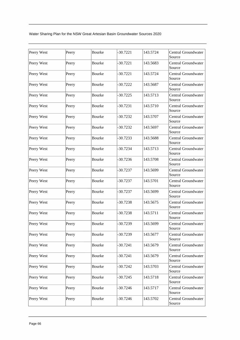
Water Sharing Plan for the NSW Great Artesian Basin Groundwater Sources 2020
Page 66
Peery West Peery Bourke -30.7221 143.5724 Central Groundwater
Source
Peery West Peery Bourke -30.7221 143.5683 Central Groundwater
Source
Peery West Peery Bourke -30.7221 143.5724 Central Groundwater
Source
Peery West Peery Bourke -30.7222 143.5687 Central Groundwater
Source
Peery West Peery Bourke -30.7225 143.5713 Central Groundwater
Source
Peery West Peery Bourke -30.7231 143.5710 Central Groundwater
Source
Peery West Peery Bourke -30.7232 143.5707 Central Groundwater
Source
Peery West Peery Bourke -30.7232 143.5697 Central Groundwater
Source
Peery West Peery Bourke -30.7233 143.5688 Central Groundwater
Source
Peery West Peery Bourke -30.7234 143.5713 Central Groundwater
Source
Peery West Peery Bourke -30.7236 143.5708 Central Groundwater
Source
Peery West Peery Bourke -30.7237 143.5699 Central Groundwater
Source
Peery West Peery Bourke -30.7237 143.5701 Central Groundwater
Source
Peery West Peery Bourke -30.7237 143.5699 Central Groundwater
Source
Peery West Peery Bourke -30.7238 143.5675 Central Groundwater
Source
Peery West Peery Bourke -30.7238 143.5711 Central Groundwater
Source
Peery West Peery Bourke -30.7239 143.5699 Central Groundwater
Source
Peery West Peery Bourke -30.7239 143.5677 Central Groundwater
Source
Peery West Peery Bourke -30.7241 143.5679 Central Groundwater
Source
Peery West Peery Bourke -30.7241 143.5679 Central Groundwater
Source
Peery West Peery Bourke -30.7242 143.5703 Central Groundwater
Source
Peery West Peery Bourke -30.7245 143.5718 Central Groundwater
Source
Peery West Peery Bourke -30.7246 143.5717 Central Groundwater
Source
Peery West Peery Bourke -30.7246 143.5702 Central Groundwater
Source

Water Sharing Plan for the NSW Great Artesian Basin Groundwater Sources 2020
Page 67
Peery West Peery Bourke -30.7247 143.5705 Central Groundwater
Source
Peery West Peery Bourke -30.7247 143.5700 Central Groundwater
Source
Peery West Peery Bourke -30.7247 143.5702 Central Groundwater
Source
Peery West Peery Bourke -30.7248 143.5720 Central Groundwater
Source
Peery West Peery Bourke -30.7248 143.5720 Central Groundwater
Source
Peery West Peery Bourke -30.7250 143.5714 Central Groundwater
Source
Peery West Peery Bourke -30.7251 143.5687 Central Groundwater
Source
Peery West Peery Bourke -30.7252 143.5701 Central Groundwater
Source
Peery West Peery Bourke -30.7252 143.5701 Central Groundwater
Source
Peery West Peery Bourke -30.7253 143.5702 Central Groundwater
Source
Peery West Peery Bourke -30.7253 143.5703 Central Groundwater
Source
Peery West Peery Bourke -30.7253 143.5683 Central Groundwater
Source
Peery West Peery Bourke -30.7254 143.5706 Central Groundwater
Source
Peery West Peery Bourke -30.7255 143.5683 Central Groundwater
Source
Peery West Peery Bourke -30.7256 143.5684 Central Groundwater
Source
Peery West Peery Bourke -30.7257 143.5716 Central Groundwater
Source
Peery West Peery Bourke -30.7257 143.5709 Central Groundwater
Source
Peery West Peery Bourke -30.7258 143.5711 Central Groundwater
Source
Peery West Peery Bourke -30.7258 143.5726 Central Groundwater
Source
Peery West Peery Bourke -30.7259 143.5714 Central Groundwater
Source
Peery West Peery Bourke -30.7259 143.5714 Central Groundwater
Source
Peery West Peery Bourke -30.7259 143.5721 Central Groundwater
Source
Peery West Peery Bourke -30.7260 143.5715 Central Groundwater
Source
Peery West Peery Bourke -30.7260 143.5716 Central Groundwater
Source

Water Sharing Plan for the NSW Great Artesian Basin Groundwater Sources 2020
Page 68
Peery West Peery Bourke -30.7260 143.5693 Central Groundwater
Source
Peery West Peery Bourke -30.7261 143.5720 Central Groundwater
Source
Peery West Peery Bourke -30.7262 143.5725 Central Groundwater
Source
Peery West Peery Bourke -30.7262 143.5721 Central Groundwater
Source
Peery West Peery Bourke -30.7263 143.5726 Central Groundwater
Source
Peery West Peery Bourke -30.7264 143.5720 Central Groundwater
Source
Peery West Peery Bourke -30.7265 143.5729 Central Groundwater
Source
Peery West Peery Bourke -30.7266 143.5725 Central Groundwater
Source
Peery West Peery Bourke -30.7266 143.5721 Central Groundwater
Source
Peery West Peery Bourke -30.7266 143.5725 Central Groundwater
Source
Peery West Peery Bourke -30.7266 143.5719 Central Groundwater
Source
Peery West Peery Bourke -30.7267 143.5701 Central Groundwater
Source
Peery West Peery Bourke -30.7267 143.5702 Central Groundwater
Source
Peery West Peery Bourke -30.7268 143.5726 Central Groundwater
Source
Peery West Peery Bourke -30.7268 143.5702 Central Groundwater
Source
Peery West Peery Bourke -30.7268 143.5735 Central Groundwater
Source
Peery West Peery Bourke -30.7268 143.5733 Central Groundwater
Source
Peery West Peery Bourke -30.7268 143.5702 Central Groundwater
Source
Peery West Peery Bourke -30.7268 143.5736 Central Groundwater
Source
Peery West Peery Bourke -30.7268 143.5726 Central Groundwater
Source
Peery West Peery Bourke -30.7268 143.5734 Central Groundwater
Source
Peery West Peery Bourke -30.7269 143.5735 Central Groundwater
Source
Peery West Peery Bourke -30.7269 143.5701 Central Groundwater
Source
Peery West Peery Bourke -30.7270 143.5701 Central Groundwater
Source

Water Sharing Plan for the NSW Great Artesian Basin Groundwater Sources 2020
Page 69
Peery West Peery Bourke -30.7270 143.5703 Central Groundwater
Source
Peery West Peery Bourke -30.7270 143.5738 Central Groundwater
Source
Peery West Peery Bourke -30.7270 143.5739 Central Groundwater
Source
Peery West Peery Bourke -30.7270 143.5705 Central Groundwater
Source
Peery West Peery Bourke -30.7270 143.5715 Central Groundwater
Source
Peery West Peery Bourke -30.7270 143.5728 Central Groundwater
Source
Peery West Peery Bourke -30.7271 143.5722 Central Groundwater
Source
Peery West Peery Bourke -30.7271 143.5719 Central Groundwater
Source
Peery West Peery Bourke -30.7272 143.5723 Central Groundwater
Source
Peery West Peery Bourke -30.7272 143.5739 Central Groundwater
Source
Peery West Peery Bourke -30.7272 143.5722 Central Groundwater
Source
Peery West Peery Bourke -30.7272 143.5741 Central Groundwater
Source
Peery West Peery Bourke -30.7273 143.5723 Central Groundwater
Source
Peery West Peery Bourke -30.7273 143.5727 Central Groundwater
Source
Peery West Peery Bourke -30.7273 143.5732 Central Groundwater
Source
Peery West Peery Bourke -30.7273 143.5727 Central Groundwater
Source
Peery West Peery Bourke -30.7275 143.5728 Central Groundwater
Source
Peery West Peery Bourke -30.7275 143.5729 Central Groundwater
Source
Peery West Peery Bourke -30.7275 143.5728 Central Groundwater
Source
Peery West Peery Bourke -30.7275 143.5723 Central Groundwater
Source
Peery West Peery Bourke -30.7275 143.5731 Central Groundwater
Source
Peery West Peery Bourke -30.7277 143.5726 Central Groundwater
Source
Peery West Peery Bourke -30.7277 143.5723 Central Groundwater
Source
Peery West Peery Bourke -30.7277 143.5724 Central Groundwater
Source

Water Sharing Plan for the NSW Great Artesian Basin Groundwater Sources 2020
Page 70
Peery West Peery Bourke -30.7278 143.5742 Central Groundwater
Source
Peery West Peery Bourke -30.7279 143.5728 Central Groundwater
Source
Peery East 9 Peery Bourke -30.7279 143.6130 Central Groundwater
Source
Peery West Peery Bourke -30.7279 143.5728 Central Groundwater
Source
Peery West Peery Bourke -30.7280 143.5743 Central Groundwater
Source
Peery West Peery Bourke -30.7282 143.5751 Central Groundwater
Source
Peery West Peery Bourke -30.7282 143.5727 Central Groundwater
Source
Peery West Peery Bourke -30.7283 143.5726 Central Groundwater
Source
Peery West Peery Bourke -30.7283 143.5724 Central Groundwater
Source
Peery West Peery Bourke -30.7284 143.5725 Central Groundwater
Source
Peery West Peery Bourke -30.7285 143.5731 Central Groundwater
Source
Peery West Peery Bourke -30.7286 143.5733 Central Groundwater
Source
Peery West Peery Bourke -30.7287 143.5733 Central Groundwater
Source
Peery West Peery Bourke -30.7287 143.5733 Central Groundwater
Source
Peery West Peery Bourke -30.7287 143.5738 Central Groundwater
Source
Peery West Peery Bourke -30.7288 143.5744 Central Groundwater
Source
Peery West Peery Bourke -30.7289 143.5743 Central Groundwater
Source
Peery East 3 Peery Bourke -30.7291 143.6118 Central Groundwater
Source
Peery East 2 Peery Bourke -30.7291 143.6118 Central Groundwater
Source
Peery East 7 Peery Bourke -30.7291 143.6121 Central Groundwater
Source
Peery East 5 Peery Bourke -30.7292 143.6119 Central Groundwater
Source
Peery East 1 Peery Bourke -30.7292 143.6118 Central Groundwater
Source
Peery East 4 Peery Bourke -30.7292 143.6119 Central Groundwater
Source
Peery East 6 Peery Bourke -30.7292 143.6119 Central Groundwater
Source

Water Sharing Plan for the NSW Great Artesian Basin Groundwater Sources 2020
Page 71
Peery West Peery Bourke -30.7293 143.5734 Central Groundwater
Source
Peery West Peery Bourke -30.7293 143.5736 Central Groundwater
Source
Peery West Peery Bourke -30.7294 143.5739 Central Groundwater
Source
Peery West Peery Bourke -30.7294 143.5735 Central Groundwater
Source
Peery West Peery Bourke -30.7295 143.5737 Central Groundwater
Source
Peery East 8 Peery Bourke -30.7296 143.6117 Central Groundwater
Source
Peery West Peery Bourke -30.7297 143.5716 Central Groundwater
Source
Peery West Peery Bourke -30.7297 143.5725 Central Groundwater
Source
Peery West Peery Bourke -30.7299 143.5725 Central Groundwater
Source
Peery West Peery Bourke -30.7299 143.5726 Central Groundwater
Source
Peery West Peery Bourke -30.7299 143.5725 Central Groundwater
Source
Peery West Peery Bourke -30.7299 143.5726 Central Groundwater
Source
Peery West Peery Bourke -30.7299 143.5727 Central Groundwater
Source
Peery West Peery Bourke -30.7299 143.5721 Central Groundwater
Source
Peery West Peery Bourke -30.7300 143.5728 Central Groundwater
Source
Peery West Peery Bourke -30.7300 143.5721 Central Groundwater
Source
Peery West Peery Bourke -30.7301 143.5727 Central Groundwater
Source
Peery West Peery Bourke -30.7301 143.5725 Central Groundwater
Source
Peery West Peery Bourke -30.7302 143.5724 Central Groundwater
Source
Picnic Sandhill Mud Picnic Sandhill
Mud
Bourke -29.1333 144.6700 Warrego
Groundwater Source
Pullamonga Pullamonga Bourke -29.5147 145.2780 Warrego
Groundwater Source
Sandy Sandy Bourke -29.1700 146.5800 Warrego
Groundwater Source
Scrubber Scrubber Bourke -29.5095 146.1469 Warrego
Groundwater Source
Scrubber Scrubber Bourke -29.5096 146.1470 Warrego
Groundwater Source

Water Sharing Plan for the NSW Great Artesian Basin Groundwater Sources 2020
Page 72
Sweetwater Sweetwater Bourke -29.4308 145.7323 Warrego
Groundwater Source
Tanawanta Mud Tanawanta
Mud
Bourke -29.3801 145.3405 Warrego
Groundwater Source
Tanawanta Mud Tanawanta
Mud
Bourke -29.3935 145.3047 Warrego
Groundwater Source
Tanawanta Mud Tanawanta
Mud
Bourke -29.3745 145.3375 Warrego
Groundwater Source
Tanawanta Mud Tanawanta
Mud
Bourke -29.3811 145.3425 Warrego
Groundwater Source
Tanawanta Mud Tanawanta
Mud
Bourke -29.3748 145.3371 Warrego
Groundwater Source
Tego Tego Bourke -28.8488 146.7921 Warrego
Groundwater Source
Tego Tego Bourke -28.8493 146.7909 Warrego
Groundwater Source
Tego Tego Bourke -28.8496 146.7919 Warrego
Groundwater Source
Tego Tego Bourke -28.8500 146.7917 Warrego
Groundwater Source
Tego Tego Bourke -28.8501 146.7914 Warrego
Groundwater Source
Tego Tego Bourke -28.8502 146.7913 Warrego
Groundwater Source
Tego Tego Bourke -28.8508 146.7921 Warrego
Groundwater Source
Thooro Thooro Bourke -29.3695 145.3755 Warrego
Groundwater Source
Thooro Mud Thooro Mud Bourke -29.3962 145.3040 Warrego
Groundwater Source
Thooro Mud Thooro Mud Bourke -29.3964 145.3033 Warrego
Groundwater Source
Thooro Mud Thooro Mud Bourke -29.3970 145.3028 Warrego
Groundwater Source
Thooro Mud Thooro Mud Bourke -29.3957 145.3057 Warrego
Groundwater Source
Thooro Mud Thooro Mud Bourke -29.3957 145.3021 Warrego
Groundwater Source
Thooro Mud Thooro Mud Bourke -29.3979 145.3043 Warrego
Groundwater Source
Thooro Mud Thooro Mud Bourke -29.3978 145.3063 Warrego
Groundwater Source
Thooro Mud Thooro Mud Bourke -29.3978 145.3230 Warrego
Groundwater Source
Thooro Mud Thooro Mud Bourke -29.3988 145.3229 Warrego
Groundwater Source
Thooro Mud Thooro Mud Bourke -29.3984 145.3227 Warrego
Groundwater Source

Water Sharing Plan for the NSW Great Artesian Basin Groundwater Sources 2020
Page 73
Thooro Mud Thooro Mud Bourke -29.3963 145.3207 Warrego
Groundwater Source
Thooro Mud Thooro Mud Bourke -29.3969 145.3030 Warrego
Groundwater Source
Thooro Mud Thooro Mud Bourke -29.3974 145.3064 Warrego
Groundwater Source
Thooro Mud Thooro Mud Bourke -29.3975 145.3063 Warrego
Groundwater Source
Thooro Mud Thooro Mud Bourke -29.3975 145.3080 Warrego
Groundwater Source
Thooro Mud Thooro Mud Bourke -29.3969 145.3072 Warrego
Groundwater Source
Thooro Mud Thooro Mud Bourke -29.3971 145.3081 Warrego
Groundwater Source
Thooro Mud Thooro Mud Bourke -29.3944 145.3065 Warrego
Groundwater Source
Thooro Mud Thooro Mud Bourke -29.3945 145.3072 Warrego
Groundwater Source
Thooro Mud Thooro Mud Bourke -29.3931 145.3057 Warrego
Groundwater Source
Thooro Mud Thooro Mud Bourke -29.3803 145.3406 Warrego
Groundwater Source
Thooro Mud Thooro Mud Bourke -29.3961 145.3041 Warrego
Groundwater Source
Thooro Mud Thooro Mud Bourke -29.3994 145.3216 Warrego
Groundwater Source
Thooro Mud Thooro Mud Bourke -29.3984 145.3227 Warrego
Groundwater Source
Thooro Mud Thooro Mud Bourke -29.3961 145.3039 Warrego
Groundwater Source
Thooro Mud Thooro Mud Bourke -29.3995 145.3214 Warrego
Groundwater Source
Thooro Mud Thooro Mud Bourke -29.3917 145.3041 Warrego
Groundwater Source
Thooro Mud Thooro Mud Bourke -29.3918 145.3042 Warrego
Groundwater Source
Thooro Mud Thooro Mud Bourke -29.3918 145.3044 Warrego
Groundwater Source
Thooro Mud Thooro Mud Bourke -29.3924 145.3044 Warrego
Groundwater Source
Thooro Mud Thooro Mud Bourke -29.3926 145.3048 Warrego
Groundwater Source
Thooro Mud Thooro Mud Bourke -29.3937 145.3063 Warrego
Groundwater Source
Thooro Mud Thooro Mud Bourke -29.3937 145.3048 Warrego
Groundwater Source
Thooro Mud Thooro Mud Bourke -29.3948 145.3038 Warrego
Groundwater Source

Water Sharing Plan for the NSW Great Artesian Basin Groundwater Sources 2020
Page 74
Thooro Mud Thooro Mud Bourke -29.3953 145.3067 Warrego
Groundwater Source
Thooro Mud Thooro Mud Bourke -29.3963 145.3207 Warrego
Groundwater Source
Thooro Mud Thooro Mud Bourke -29.3966 145.3070 Warrego
Groundwater Source
Thooro Mud Thooro Mud Bourke -29.3968 145.3029 Warrego
Groundwater Source
Thooro Mud Thooro Mud Bourke -29.3974 145.3067 Warrego
Groundwater Source
Thooro Mud Thooro Mud Bourke -29.3974 145.3077 Warrego
Groundwater Source
Thooro Mud Thooro Mud Bourke -29.3976 145.3070 Warrego
Groundwater Source
Thooro Mud Thooro Mud Bourke -29.3977 145.3230 Warrego
Groundwater Source
Thully Thully Bourke -29.7160 146.2843 Warrego
Groundwater Source
Thully Thully Bourke -29.7162 146.2849 Warrego
Groundwater Source
Thully Thully Bourke -29.7161 146.2837 Warrego
Groundwater Source
Thully Thully Bourke -29.7166 146.2843 Warrego
Groundwater Source
Thully Thully Bourke -29.7157 146.2846 Warrego
Groundwater Source
Thully Thully Bourke -29.7160 146.2849 Warrego
Groundwater Source
Tooloomi Tooloomi Non-GAB -29.1922 146.5875 Warrego
Groundwater Source
Tooloomi Tooloomi Non-GAB -29.1958 146.5808 Warrego
Groundwater Source
Yotomi Tooloomi Non-GAB -29.2014 146.5510 Warrego
Groundwater Source
Toulby Toulby Bourke -29.0193 146.9304 Warrego
Groundwater Source
Towry Towry Bourke -28.9707 146.9251 Warrego
Groundwater Source
Towry Towry Bourke -28.9708 146.9237 Warrego
Groundwater Source
Towry Towry Bourke -28.9716 146.9255 Warrego
Groundwater Source
Towry Towry Bourke -28.9728 146.9292 Warrego
Groundwater Source
Towry Towry Bourke -28.9732 146.9262 Warrego
Groundwater Source
Towry Towry Bourke -28.9743 146.9268 Warrego
Groundwater Source
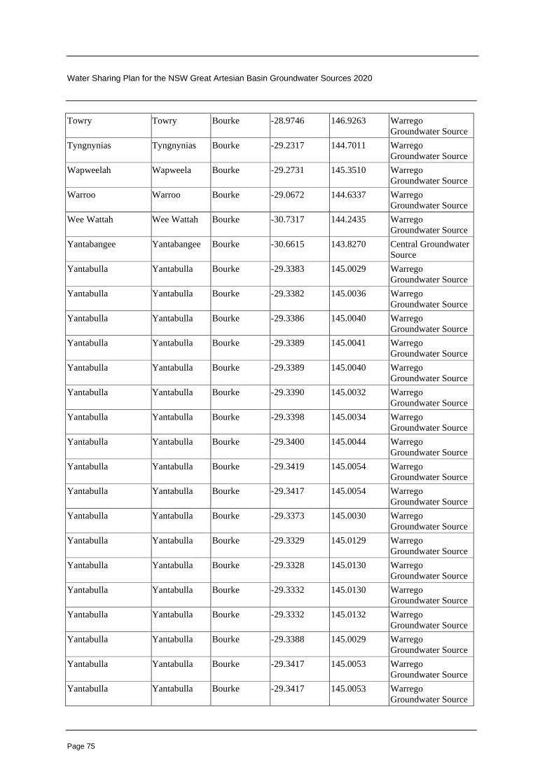
Water Sharing Plan for the NSW Great Artesian Basin Groundwater Sources 2020
Page 75
Towry Towry Bourke -28.9746 146.9263 Warrego
Groundwater Source
Tyngnynias Tyngnynias Bourke -29.2317 144.7011 Warrego
Groundwater Source
Wapweelah Wapweela Bourke -29.2731 145.3510 Warrego
Groundwater Source
Warroo Warroo Bourke -29.0672 144.6337 Warrego
Groundwater Source
Wee Wattah Wee Wattah Bourke -30.7317 144.2435 Warrego
Groundwater Source
Yantabangee Yantabangee Bourke -30.6615 143.8270 Central Groundwater
Source
Yantabulla Yantabulla Bourke -29.3383 145.0029 Warrego
Groundwater Source
Yantabulla Yantabulla Bourke -29.3382 145.0036 Warrego
Groundwater Source
Yantabulla Yantabulla Bourke -29.3386 145.0040 Warrego
Groundwater Source
Yantabulla Yantabulla Bourke -29.3389 145.0041 Warrego
Groundwater Source
Yantabulla Yantabulla Bourke -29.3389 145.0040 Warrego
Groundwater Source
Yantabulla Yantabulla Bourke -29.3390 145.0032 Warrego
Groundwater Source
Yantabulla Yantabulla Bourke -29.3398 145.0034 Warrego
Groundwater Source
Yantabulla Yantabulla Bourke -29.3400 145.0044 Warrego
Groundwater Source
Yantabulla Yantabulla Bourke -29.3419 145.0054 Warrego
Groundwater Source
Yantabulla Yantabulla Bourke -29.3417 145.0054 Warrego
Groundwater Source
Yantabulla Yantabulla Bourke -29.3373 145.0030 Warrego
Groundwater Source
Yantabulla Yantabulla Bourke -29.3329 145.0129 Warrego
Groundwater Source
Yantabulla Yantabulla Bourke -29.3328 145.0130 Warrego
Groundwater Source
Yantabulla Yantabulla Bourke -29.3332 145.0130 Warrego
Groundwater Source
Yantabulla Yantabulla Bourke -29.3332 145.0132 Warrego
Groundwater Source
Yantabulla Yantabulla Bourke -29.3388 145.0029 Warrego
Groundwater Source
Yantabulla Yantabulla Bourke -29.3417 145.0053 Warrego
Groundwater Source
Yantabulla Yantabulla Bourke -29.3417 145.0053 Warrego
Groundwater Source

Water Sharing Plan for the NSW Great Artesian Basin Groundwater Sources 2020
Page 76
Paralna Youltoo Bourke -30.5250 143.1304 Central Groundwater
Source
Youltoo Youltoo Bourke -30.5772 143.1008 Central Groundwater
Source
Youngerina Youngerina Bourke -29.5246 145.1296 Warrego
Groundwater Source
Youngerina Youngerina Bourke -29.5421 145.1209 Warrego
Groundwater Source
Youngerina Youngerina Bourke -29.5435 145.1201 Warrego
Groundwater Source
Youngerina Youngerina Bourke -29.5437 145.1201 Warrego
Groundwater Source
Youngerina Youngerina Bourke -29.5441 145.1225 Warrego
Groundwater Source
Youngerina Youngerina Bourke -29.5442 145.1225 Warrego
Groundwater Source
Table B—High priority spring groundwater dependent ecosystems
Column 1 Column 2 Column 3 Column 4
High priority groundwater
dependent ecosystem
Latitude -Decimal
degrees (South)
Longitude -Decimal
degrees (East)
Groundwater
Source
Lawlers Spring -30.0817 150.0344 Southern Recharge
O’Connors Spring -29.3983 150.8678 Eastern Recharge
Rocky Holes Springs -29.3150 150.3678 Eastern Recharge
Ulungra Springs -31.7150 149.1011 Southern Recharge
Wheoh Spring -31.2150 149.0844 Southern Recharge
Wittenbra Springs -31.0650 149.2011 Southern Recharge
Yearinan Springs -31.1817 149.1844 Southern Recharge
Hassells Spring -31.7483 149.0178 Southern Recharge
Gidgenboyne Spring -31.7483 149.0178 Southern Recharge
Cookamobla Springs -31.5150 149.3094 Southern Recharge
Dandry North Springs -31.0317 149.2844 Southern Recharge
Dandry Springs -31.1483 149.3178 Southern Recharge
Eather Spring -30.6817 149.8344 Southern Recharge
Garrawilla Spring -31.1483 149.6344 Southern Recharge
Gora Spring -31.0817 149.0678 Southern Recharge
Jackys Spring -29.4483 150.4678 Eastern Recharge
Grattai Spring -30.0983 150.0678 Southern Recharge
Hickeys Spring -29.4483 150.5011 Eastern Recharge
Barnsbys Springs -29.9650 150.1678 Southern Recharge
Boggy Spring -29.4483 150.4844 Eastern Recharge
Coxs Spring -29.3650 150.6844 Eastern Recharge
Cucumber Springs -29.3317 150.8844 Eastern Recharge
Stump Spring -29.4650 150.5011 Eastern Recharge

Water Sharing Plan for the NSW Great Artesian Basin Groundwater Sources 2020
Page 77
Appendix 1 Overview of the Plan Map (clause 4)
Overview of the Plan Map (WSP040_Version 2), Water Sharing Plan for the NSW Great Artesian Basin Groundwater Sources 2020

Water Sharing Plan for the NSW Great Artesian Basin Groundwater Sources 2020
Page 78
Appendix 2 Overview of the High Priority Groundwater-Dependent
Ecosystem Map (clauses 4, 39 and 41)
Overview of the High Priority Groundwater-Dependent Ecosystem Map (GDE025_Version 1), Water Sharing Plan for the NSW Great Artesian Basin Groundwater Sources 2020

Water Sharing Plan for the NSW Great Artesian Basin Groundwater Sources 2020
Page 79
Appendix 3 Map of the High Priority Groundwater-Dependent Ecosystems
identified in Schedule 2 (clauses 4, 39 and 41)
Map of the High Priority Groundwater-Dependent Ecosystems identified in Schedule 2