water management & technical flood...
TRANSCRIPT

Technology Dialogue - Solutions on Sustainable Water Management and Flood Prevention September 20th, 2012, Ministry of Foreign Affairs, Narathip Auditorium, Bangkok 1
Dr.-Ing. Bernd Kordes President and CEO Lahmeyer International GmbH
Water Management & Technical Flood Protection
A 2.1 Classification of Flooding Zones / Natural Retention Areas

Technology Dialogue - Solutions on Sustainable Water Management and Flood Prevention September 20th, 2012, Ministry of Foreign Affairs, Narathip Auditorium, Bangkok 2
Flood Risk Maps (FRM)
A 2.1 Classification of Flooding Zones / Natural Retention Areas
FRM is a basic tool for presenting and sharing information on existing flood risks FRM are based on • hydrological data on flood events • observed flood boundaries (e.g. by satellite photos) • digital terrain models • hydraulic flow modelling FRM indicate where overflow may occur, to • professionally define flood plains/retention areas • identify areas at risk of flooding • define flood control measures
Two dimensional flow model of Isar River; own source

Technology Dialogue - Solutions on Sustainable Water Management and Flood Prevention September 20th, 2012, Ministry of Foreign Affairs, Narathip Auditorium, Bangkok 3
Flood Plains / Retention Areas
A 2.1 Classification of Flooding Zones / Natural Retention Areas
Flood Plains are outlying areas that serve to retain water naturally and provide damage free flood discharge Flood plains require protection by law, to avoid • Any modification of the topography, increase or decrease of land • Construction, demolition or substancial modification of buildings
Elbe River floods; own source

Technology Dialogue - Solutions on Sustainable Water Management and Flood Prevention September 20th, 2012, Ministry of Foreign Affairs, Narathip Auditorium, Bangkok 4
Build-up Areas / Protected Areas
A 2.1 Classification of Flooding Zones / Natural Retention Areas
Areas at risk of flooding (one in 100 years flood), such as • Residential areas • Industrial areas (e.g. with storage of water hazardous substances like fuel oil) Measures • protection dykes or walls (permanent structures) • mobile flood protection systems (installed during floods) • drainage systems to release backwater
Source: www.welt.de
own Source

Technology Dialogue - Solutions on Sustainable Water Management and Flood Prevention September 20th, 2012, Ministry of Foreign Affairs, Narathip Auditorium, Bangkok 5
Flood Risk Maps are essential for:
A 2.1 Classification of Flooding Zones / Natural Retention Areas
Alert Action Plans • Specifying of necessary measures • Setting priorities for the alert • Action planning Risk prevention through insurance • Proper appraisal of damage risks, to allow appropriate
insurance policies and calculation of level of premium Public Awareness • to allow people to assess the possible risk and to take
appropriate precaution measures by themthelves
own Source

Technology Dialogue - Solutions on Sustainable Water Management and Flood Prevention September 20th, 2012, Ministry of Foreign Affairs, Narathip Auditorium, Bangkok 6
Lahmeyer International Consulting Engineering Company in the field of Water, Energy and Transportation
A 2.1 Classification of Flooding Zones / Natural Retention Areas
Special knowledge: • Strategic Flood Risk Management • Flood Risk Maps (GIS techniques) • Hydraulic Flow Modelling • Dams, Dykes, Flood Channels, Mobile Flood Protection Systems

Technology Dialogue - Solutions on Sustainable Water Management and Flood Prevention September 20th, 2012, Ministry of Foreign Affairs, Narathip Auditorium, Bangkok 7
Genale-Dawa River Basin Integrated Resources Development Master Plan, Ethiopia
A 2.1 Classification of Flooding Zones / Natural Retention Areas
Main Data: •Third largest river basin in Ethiopia •Total area of the basin 168,100 km² •Total population of the basi approx. 5.1 million •Number of international experts provided 10 •Number of national experts provided 23 •RCC gravity dam: crest length/height 436m / 115m Execution: 2003 - 2009 Services: •Set-up of a basin-wide GIS database of natural and human resources •Preparation of a multi-sectoral River Basin Master Plan •Project development at feasibility level for agricultural, livestock and water resources development projects
E T H I O P I A
Technology Dialogue - Solutions on Sustainable Water Management and Flood Prevention September 20th, 2012, Ministry of Foreign Affairs, Narathip Auditorium, Bangkok 8
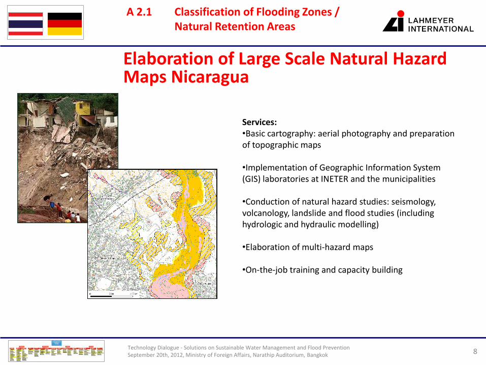
Elaboration of Large Scale Natural Hazard Maps Nicaragua
A 2.1 Classification of Flooding Zones / Natural Retention Areas
Services: •Basic cartography: aerial photography and preparation of topographic maps •Implementation of Geographic Information System (GIS) laboratories at INETER and the municipalities •Conduction of natural hazard studies: seismology, volcanology, landslide and flood studies (including hydrologic and hydraulic modelling) •Elaboration of multi-hazard maps •On-the-job training and capacity building

Technology Dialogue - Solutions on Sustainable Water Management and Flood Prevention September 20th, 2012, Ministry of Foreign Affairs, Narathip Auditorium, Bangkok 9
Flood Retention Polder
A 2.1 Classification of Flooding Zones / Natural Retention Areas
Main data: •Volume of Polder 11 Mio. m³ •Rehabilitation of dykes 9 km •New dykes 1,85 km
Services: •Preliminary Planning •Groundwater Modelling •Environmental Planning •Surveying and Setting

Technology Dialogue - Solutions on Sustainable Water Management and Flood Prevention September 20th, 2012, Ministry of Foreign Affairs, Narathip Auditorium, Bangkok 10
Lahmeyer Expertise in Solution Map for Sustainable Water and Flood Management
A 2.1 Classification of Flooding Zones / Natural Retention Areas

Technology Dialogue - Solutions on Sustainable Water Management and Flood Prevention September 20th, 2012, Ministry of Foreign Affairs, Narathip Auditorium, Bangkok 11
A 2.1 Classification of Flooding Zones / Natural Retention Areas
Flood protection dyke along Elbe River

Technology Dialogue - Solutions on Sustainable Water Management and Flood Prevention September 20th, 2012, Ministry of Foreign Affairs, Narathip Auditorium, Bangkok 12
A 2.1 Classification of Flooding Zones / Natural Retention Areas
Flood protection wall, Dresden; combined permanent with mobile structure

Technology Dialogue - Solutions on Sustainable Water Management and Flood Prevention September 20th, 2012, Ministry of Foreign Affairs, Narathip Auditorium, Bangkok 13
A 2.1 Classification of Flooding Zones / Natural Retention Areas
Mobile flood protection wall