water infrastructure study - civicweb
TRANSCRIPT

Report to District of Sparwood
Water Infrastructure Study
January 22, 2013
McElhanney Consulting Services Ltd. www.mcelhanney.com
2511 00275-0


Report to District of Sparwood Water Infrastructure Study
2511 00275-00 i
Table of Contents
1 Introduction 11.1 Background ....................................................................................................................... 1
1.2 Past Studies and Reports ................................................................................................. 2
1.3 Project Objectives and Scope ........................................................................................... 2
2 Project Methodology 42.1 Design Criteria .................................................................................................................. 4
2.2 Supporting Background Data and Information .................................................................. 5
2.3 Existing and Future Demands ........................................................................................... 5
2.4 Water Model ...................................................................................................................... 62.4.1 Model Background 62.4.2 Model Verification and Adjustments 6
3 Existing Water System Evaluation 73.1 Existing System Overview ................................................................................................. 7
3.2 Existing System Performance ........................................................................................... 73.2.1 Water Supply 73.2.2 Distribution System 83.2.3 Daily Water Supply 93.2.4 Fire Protection 10
4 Future Water System Evaluation 114.1 Future System Overview ................................................................................................. 11
4.2 Future Water System Upgrades ...................................................................................... 114.2.1 Future Storage Tanks 114.2.2 Future Distribution System 12
4.3 Michel Creek Area ........................................................................................................... 13
4.4 Sparwood Drive Area ...................................................................................................... 14
4.5 Teck /Joy Global Area ..................................................................................................... 14
4.6 Downtown Core Area ...................................................................................................... 15
4.7 Whiskey Jack Area .......................................................................................................... 15
5 Cost estimates 165.1 General ........................................................................................................................... 16
5.2 Cost Estimates ................................................................................................................ 16

Report to District of Sparwood Water Infrastructure Study
2511 00275-00 ii
5.3 Cost Summary ................................................................................................................ 18
5.4 Phased construction ........................................................................................................ 19
6 Conclusion and Recommendations 206.1 General ........................................................................................................................... 20
6.2 Conclusions..................................................................................................................... 20
6.3 Recommendations .......................................................................................................... 20
Appendix A: WaterCAD Model 22
TablesTable 1 Areas of Study ............................................................................................................ 1
Table 2 Existing and Future Demands .................................................................................... 5
Table 3 Cost Estimate.............................................................................................................16
FiguresFigure 1 Project Location and Overview following 1
Figure 2 Official Community Plan following 5
Figure 3 Existing Model Schematic following 5
Figure 4 Existing Water System following 7
Figure 5 Future Water System (Option 1) following 12
Figure 6 Future Water System (Option 2) following 12
Figure 5 Future Water System (Whiskey Jack) following 12

Report to District of Sparwood Water Infrastructure Study
2511 00275-00 Page 1
1 INTRODUCTIONMcElhanney Consulting Services Ltd. (MCSL) has been retained by the District of Sparwood (the District) to undertake an evaluation of the District’s current water distribution system. The intent of this evaluation is to identify key constraints of the existing system that limit the District’s ability to provide domestic water flows and fire flow protection. In addition, the system was evaluated for future expansion to service developments that are proposed throughout the District. The need for this study was identified when several proposed development projects for the near future and previous studies all identified constraints within the current water system to support continued growth in the community. The purpose of this study is to undertake a unified analysis of the entire water system to confirm existing performance and constraints and then determine network and local upgrades required for specific areas, where development and future growth are planned.
1.1 BACKGROUNDHistorically, Sparwood has been a mining and industrial community that has grown to include many community sectors and amenities. Sparwood has a mix of existing developments ranging from residential areas in the downtown and northern areas, to light commercial and industrial uses throughout the downtown proper and southern regions. The District continues to grow with recently approved developments and new applications for future developments are expected throughout the community.
In the past year, several development applications have been processed in the District. The existing water system was evaluated, in the past, to identify overall upgrades that may be required to support future developments, in a general context. MCSL is currently working on several projects within the District including the design and construction of the Michel Creek area watermains. MCSL completed a review of the District’s water model during the design for this project to confirm system performance and watermain sizing. Since then MCSL has provided water modelling analysis and system planning, in isolation, for other areas, when needed, to support future developments.
This water infrastructure study is a summary of the consolidated analysis of the existing water system and provides recommendations for both specific developments and overall community upgrades to support the on-going and future growth of the community.
Outlined on Figure 1 is the overall project location and specific areas of the District that were the key focus areas of this study. These specific areas include: Table 1 Areas of Study
Area OverviewMichel Creek Recently designed and constructed watermains throughout the
area. The District’s current water model was referenced during the design phase.
Teck/Joy Global Future industrial development proposed in the area. Upgraded water modelling was completed to identify servicing restrictions and required upgrades to improve the water supply and fire suppression.
Sparwood Drive Future industrial development proposed for this area. Upgraded water modelling was completed to identify servicing restrictions

DA
TE:J
anua
ry 2
2, 2
013
,4:3
4 P
M
FILE
: M
:\Pro
j\251
1-00
275-
0 M
iche
l Cre
ek R
d W
ater
mai
n\10
.0 D
RA
WIN
GS
\10.
3 E
ngin
eerin
g\10
.3.4
Ske
tche
s\Fi
gure
s.dw
g
FIGURE 1PROJECT LOCATION &
OVERVIEWScale: 1:40,000Date: JANUARY 2013Job No.: 2511-00275-0
LEGEND
Whiskey Jack Area
Michel Creek Area
Teck / Joy Global Area
Sparwood Drive Area
Municipal Boundary

Report to District of Sparwood Water Infrastructure Study
2511 00275-00 Page 2
and required upgrades to improve the water supply and fire suppression. Also reviewed the existing downtown area to include recently constructed watermains into the water model and calculate existing fire flow availability.
Whiskey Jack Area Recently constructed residential development and planned mixed use development throughout the area. Upgraded water modelling was completed to identify servicing restrictions and required upgrades to improve the water supply and fire suppression.
1.2 PAST STUDIES AND REPORTS The District’s water supply and distribution system has been the subject of past reports and studies. In 1998, UMA Engineering Ltd. (UMA) completed a servicing study for the Douglas Fir Road/Sparwood Drive area which included a review of the entire District’s water distribution system. The report provided several recommendations:
Construct a trunk watermain from the Sparwood Proper Reservoir, Introduce cross looping from Douglas Fir Road and Sparwood Drive, and Construct a storage reservoir when the area is fully developed.
In 2006, a technical supplement to the District’s Official Community Plan (OCP) was prepared by UMA that further reviewed the District’s water distribution system on a more macro level scale. That report provided detailed information on existing supply and distribution capacity and recommended several system improvements as development proceeds throughout the District. Notable system recommendations for the future expansion, which was confirmed by this study, included the need for a new reservoir, supply main and booster pump station to service the Whiskey Jack area. These are necessary when development proceeds above an elevation of 1170 m where the current Sparwood Heights reservoir is not capable of delivering water at sufficient pressure to support development at the higher elevations in the area.
1.3 PROJECT OBJECTIVES AND SCOPE A clearly defined scope of work was established prior to project commencement. The intent of the study was to determine the capacity limits within the existing water network and determine system improvements that would allow community growth in support of the District’s OCP.
The following outlines the primary goals and objectives of the study:
Review and confirm the capacity of the existing water system; Complete understanding of the existing water network including performance and constraints; Determine the supporting water infrastructure necessary to service planned development areas; Determine community-wide system improvements necessary to service planned development areas; and Review the District’s future long-term development plans and recommend water system improvements in support of the community’s growth strategy, as envisioned in the OCP.
The following scope was established and followed to achieve the goals and objectives of this study:

Report to District of Sparwood Water Infrastructure Study
2511 00275-00 Page 3
Kick-off meeting to clarify the scope of work and determine the District’s land use, population horizons, growth rate, and growth areas; Gather and process information from Sparwood, such as Lidar® mapping data, cadastral/legal plans, aerial photography, as-builts, past reports, and other information pertaining to this water study;Review design criteria, modelling standards including fire suppression, water demands, and allowable pressures; Complete a general Quality Control assessment and calibration of the existing model. This included review of input demands, elevations, pipe sizes, and input any recent information provided to prepare a water model reflective of the District’s current infrastructure; Review the existing supply sources and distribution systems to confirm their performance and identify current system constraints and opportunities; Recommend future system upgrades, such as system expansion, through water modelling analysis in order to support expansion into the four developing areas referred to earlier; and Prepare a draft report for review by the District and submit a final report (this report) once review comments, received from the District are addressed.
The project scope was continually reviewed and updated as needed by both MCSL and the District during the completion of this study.

Report to District of Sparwood Water Infrastructure Study
2511 00275-00 Page 4
2 PROJECT METHODOLOGY This water infrastructure study was completed in a series of defined steps that expedited the analysis and design process. A system design criteria, which applied to this study, was reviewed along with other background data and reports and this information was used to update and calibrate the model originally supplied by the District. The water network analysis was completed with the aid of a water network computer model. Several scenarios were tested for various areas of the District to evaluate current and future conditions and upgrade improvements. Model verification was also completed using static hydrant pressure data provided by the District. Calculated total water demands were also compared with data provided by the District to confirm that total daily demands, computed by the model, were equivalent to actual measured demand data. A total of four newly developing areas were analyzed under current and future development conditions. The existing developed areas were also tested to confirm demands and the ability of the existing network to service the existing built-up areas.
2.1 DESIGN CRITERIA The design criteria used for the analysis for this study originate from Schedule “C” of District of Sparwood’s Subdivision Servicing Bylaw No 591c, 1994 and supplemented by Section 2.0 of the Master Municipal Contract Documents (MMCD) Design Guideline Manual (2005) for municipalities.
Key components of the above listed criteria references were used to establish the following design criteria, which was utilized during the analysis of the water distribution network:
1. Residential Demands
Average Daily Demand (ADD) 450 litres per capita per day (lpcd) Maximum Daily Demand (MDD) 1200 lpcd Peak Hourly Demand (PHD) 2100 lpcd
2. Non-Residential Demands
Commercial use 90 people/hectare (ha) Institutional use 50 people/ha Industrial use 90 people/ha
3. Fire Flows (FF)
Single-family residential use 60 litres per second (l/s) Multi-family residential use 90 l/s Commercial/Institutional use 150 l/s Industrial use 225 l/s
4. Allowable Water Pressures
Maximum allowable pressure 125 pounds per square inch (psi) (850 kilopascals (kPa)) desirable 100 (psi)
Minimum pressure during PHD 40 psi (280 kPa) Minimum system pressure during MDD + FF 20 psi (150 kPa)

Report to District of Sparwood Water Infrastructure Study
2511 00275-00 Page 5
All hydraulic network computations were based on the Hazen-Williams formula. Assigned flows used during the analysis were based on the PHD and MDD + FF. In all scenarios the MDD + FF was the worst case and was therefore used to determine the recommended system improvements.
2.2 SUPPORTING BACKGROUND DATA AND INFORMATION Several reports and data sources were used during the initial review stage of the study. Various data that was gathered and reviewed include:
WaterCAD© Version 8 water network model supplied by the District; Recorded water and sewage flow data from 1998 to 2011; Static hydrant pressure testing data from 1997 and 2005; Screen shots of current water system controls; Douglas Fir Road / Sparwood Drive Servicing Study (UMA, 1998); District of Sparwood 2005 Technical Supplement to OCP Plan (UMA, 2006); and Michel Creek Road Watermain Preliminary Design Report (Dillon Consulting, 2011).
2.3 EXISTING AND FUTURE DEMANDS The water network was tested for both existing and future water demands based on current and projected populations. The existing water network model that was provided by the District had existing water demands incorporated into the model. The existing network was checked and calibrated using the data provided by the District. The original model did not have any water demands for land uses other than single-family residential. Therefore water demands were entered for all existing non single-family residential sites in the community. Figure 3 identifies all sites where water demands were entered to create a current network model.
Future water demands were calculated based on the designated land uses provided in the Official Community Plan (OCP) adopted by the District. Figure 2 shows the designated land uses in the current OCP. There were specific designated land use areas that were excluded from this study and water demands were not included in any of the analyses completed. These areas were specifically identified as long-term development areas which were beyond the timeline horizon, objectives, and scope of this study. Figure 2 shows the areas excluded from the water network analysis.
Table 2 below outlines the existing and future system water demands that were calculated for the purpose of this study. Table 2 Existing and Future Demands
Average Daily Demand (ADD)
Maximum Daily Demand (MDD)
Peak Hourly Demand (PHD)
Existing 60.4 l/s 93.8 l/s 149.5 l/s
Future 145.5 l/s 208.0 l/s 302.4 l/s
The above water demands were calculated based on the design criteria as outlined in Section 2.1 above.

DATE:January 22, 2013,4:34 PM FILE: M:\Proj\2511-00275-0 Michel Creek Rd Watermain\10.0 DRAWINGS\10.3 Engineering\10.3.4 Sketches\Figures.dwg
FIG
UR
E 2
OFF
ICIA
L C
OM
MU
NIT
Y P
LAN
Sca
le: A
S S
HO
WN
Dat
e: J
AN
UA
RY
201
3Jo
b N
o.: 2
511-
0027
5-0
RE
SID
EN
TIA
L
CO
MM
ER
CIA
L
IND
US
TRIA
L
INS
TITU
TIO
NA
L
PA
RK
S A
ND
RE
CR
EA
TIO
N
GR
EE
N B
ELT
/ FL
OO
D P
LAIN
RE
CR
EA
TIO
N O
RIE
NTE
D R
ES
IDE
NTI
AL
HIG
H H
AZA
RD
ZO
NE
CIV
IC C
EN
TRE
BLO
CK
LON
GTE
RM
DE
VE
LOP
ME
NT
AR
EA
S(N
OT
INC
L. W
STU
DY
)

DATE:January 22, 2013,4:35 PM FILE: M:\Proj\2511-00275-0 Michel Creek Rd Watermain\10.0 DRAWINGS\10.3 Engineering\10.3.4 Sketches\Figures.dwg
FIG
UR
E 3
EX
ISTI
NG
MO
DE
L S
CH
EM
ATI
CS
cale
: 1:2
0,00
0D
ate:
JA
NU
AR
Y 2
013
Job
No.
: 251
1-00
275-
0
LEG
EN
D E
xist
ing
350Ø
Wat
erm
ain
Exi
stin
g 30
0Ø W
ater
mai
nE
xist
ing
250Ø
Wat
erm
ain
Exi
stin
g 20
0Ø W
ater
mai
nE
xist
ing
150Ø
Wat
erm
ain
Exi
stin
g 10
0Ø W
ater
mai
nN
ode
Nod
e Te
xtP
RV
Pum
pR
eser
voir
(Wel
l)S
tora
ge T
ank
Non
-Sin
gle
Fam
ily R
esid
entia
lD
eman
d A
reas
add
ed to
Mod
el
Not
e: N
ode
elev
atio
ns a
dd11
00m
to G
eode
tic D
atum

Report to District of Sparwood Water Infrastructure Study
2511 00275-00 Page 6
2.4 WATER MODEL Water distribution analysis was completed using a water network computer model using WaterCAD©
Version 8 software. Several scenarios were tested for various areas of the District to evaluate current and future conditions and determine short-comings in the network. Model verification was confirmed using static hydrant pressure data provided by the District. Total water demands were also compared with data provided by the District to confirm that total daily water demands calculated by the model were equivalent to actual recorded usages.
2.4.1 Model Background The original water network model was developed by UMA, which supported the finding of the TechnicalSupplement to the District’s OCP. Since then several updates to the model were completed, which included newly installed water mains, demand updates, and adjustments to pump and pressure reducing valve (PRV) settings. A subsequent update was completed by Dillon Consulting Ltd. in 2011 and included these key elements:
Updated recorded well data; Updated PRV settings and pressure zones; Calibration with known hydrant static and residual pressures; and Updated infrastructure up to 2010 based from data supplied by the District.
The model was made available to MCSL in 2011 during the detail design of the Michel Creek Road watermain project. Construction of this project was recently completed with the exception of decommissioning of the Matevic Road transfer valve (PRV-1) and installing a new PRV-3, which was one of the recommendations made in MCSL’s Pre-Design report for the Michel Creek watermain project .The Michel Creek Road watermain project still requires the relocation of this transfer valve before the Michel Creek area can achieve full residential fire flow protection and adequate operating pressures.
2.4.2 Model Verification and Adjustments As part of this study, an important step was to review the existing water network model that was provided to MCSL by the District. The objective of the review was to verify the accuracy and reliability of the model as an analysis tool for planning future water system infrastructure and upgrades. Figure 3shows the existing water network schematic, including updates to the model network that were recently constructed. MCSL completed the following:
Completed a Quality Control overview of the model to confirm model inputs; Reviewed existing water demands and compared them with flow data received from the District; Completed adjustments to water demands by including non-single-family residential sites that were not assigned in the base model; Completed adjustments to the Sparwood Proper area’s residential unit water demand value from 900 lpcd to 450 lpcd in keeping with the established design criteria for this report; Confirmed pump settings, capacities, well yields and PRV settings; and Adjusted the well and pump setting to ensure maximum pumping capacities were not exceeded.

Report to District of Sparwood Water Infrastructure Study
2511 00275-00 Page 7
3 EXISTING WATER SYSTEM EVALUATION
3.1 EXISTING SYSTEM OVERVIEW The District has constructed a water supply and distribution system, see Figure 4, to support the growth and development of the community over several decades. The District’s water supply is obtained from three underground aquifer wells, where water is pumped through two separate pump stations and distributed through the system to end users and stored in two existing water storage tanks. This water supply is currently non-chlorinated although fluoridation is added to natural amounts.
As the community has grown, development has occurred on both sides of the Elk River. However, the main water supply wells are located on the west side of the river. Well # 3 and the pump station located on the east side of the Elk River has limited supply capacity and is only able to supply sufficient water to the Sparwood Proper reservoir to meet average daily water demands. The two wells on the west side of the river are able to supplement the supply of water to the Sparwood Proper reservoir during peak periods using a 300 mm (12”) diameter watermain crossing under the Elk River and the transfer valve (PRV-1) installed on this watermain. This transfer valve is scheduled for decommissioning to improve water pressure to the Michel Creek area.
New development expansion in the Whiskey Jack area; the southern Sparwood Drive area; and the Highway 3 and Highway 43 areas are now placing increased demands on the District to provide additional water and fire protection not currently available. For example the proposed industrial development slated for the entrance to the community along Highway 3 cannot be serviced with industrial fire flows as recommended by the Fire Underwriters Survey™ and included in the District’s target design criteria (225 l/s for time duration of 3 hours). The new developments proposed for the northern regions of the community similarly requires the 225 l/s fire supply and the northwest area is at an elevation above the Sparwood Heights water reservoir and cannot be serviced without additional pumping and storage.
This section of the report summarizes the challenges and opportunities available to the District to address the shortfall in water storage and distribution to support the development potential identified in the District’s OCP. District staff confirmed that the OCP is currently under review and some adjustment may be forthcoming. They advised that the proposed industrial development along Highway 3 at the east end of the community would not be provided with industrial water supply or fire protection and therefore only sufficient water to support an office use was included in the analysis. Figure 2 shows the area referenced.
At the present time, the District is capable of providing fire protection for all single family residential areas throughout the community (60 l/s). There is insufficient storage and some under sized pipes at critical locations resulting in the inability to provide fire protection for commercial, institutional and industrial land uses to meet current Fire Underwriters Survey’s™ recommendations and the District’s target design criteria.
3.2 EXISTING SYSTEM PERFORMANCE 3.2.1 Water Supply The community’s water supply is provided by two wells located at MacKenzie Springs (Wells #1 & #2) west of the Elk River, and one well at Sparwood Proper (Well #3). The following existing capacities were confirmed using UMA’s 2006 Technical Supplement to the OCP, as follows:

DATE:January 22, 2013,4:35 PM FILE: M:\Proj\2511-00275-0 Michel Creek Rd Watermain\10.0 DRAWINGS\10.3 Engineering\10.3.4 Sketches\Figures.dwg
FIG
UR
E 4
EX
ISTI
NG
WA
TER
SY
STE
M
Sca
le: 1
:20,
000
Dat
e: J
AN
UA
RY
201
3Jo
b N
o.: 2
511-
0027
5-0
LEG
EN
D E
xist
ing
Wat
erm
ain
Exi
stin
g S
tora
ge T
ank
Exi
stin
g W
ell &
Pum
p S
tatio
nE
xist
ing
Pre
ssur
e R
educ
ing
Val
veP
ress
ure
Zone
Bou
ndar
y

Report to District of Sparwood Water Infrastructure Study
2511 00275-00 Page 8
Safe yield capacity for supply from the aquifer o Wells #1 and #2 @ 6,500 m3/dayo Well #3 @ 3,270 m3/day
Reservoir storage capacity o Sparwood Proper – 2,300 m3 (2,300,000 litres) o Sparwood Heights – 1,850 m3 (1,850,000 litres)
Pumphouse capacity (Well #1 & #2) o Well pump #1 – 3,250 m3/day (37.6 l/s) o Well pump #2 – 3,900 m3/day (45.1 l/s) o Well pump #3 – 3,270 m3/day (37.8 l/s) o Booster pump #1 – 920 m3/day (10.6 l/s) o Booster pump #2 – 6,500 m3/day (75.2 l/s) o Booster pump # 3 (backup) – 2,670 m3/day (30.9 l/s)
Pumphouse capacity (Well #3) o Well pump #3 – 3,200 m3/day (37.0 l/s) o Booster pump #1 – 920 m3/day (10.6 l/s) o Booster pump #2 – 6,500 m3/day (75.2 l/s) o Booster pump #3 (backup) – 2,670 m3/day (30.9 l/s)
The District’s ability to supply water to the community is restricted to the capacity of the wells. Well #1 and #2 are each capable of supplying 6,500 m3 per day or sustaining delivery of 75.2 l/s continuously. Well #3, which provides the supply to the Sparwood Proper reservoir, has limited capacity and is restricted to 3,200 m3 per day or 37.0 l/sec of sustained flow. Because of the capacity restriction at Well #3, the District’s operation of the water system allows additional water to be delivered to the Sparwood Proper reservoir through a transfer valve (PRV -1) on the 300 mm (12”) diameter watermain crossing the Elk River west of the Michel Creek development area. A fill valve (PRV-2) is also located on an existing 200mm diameter watermain that also crosses the Elk River. The transfer valve opens when the Sparwood Proper reservoir falls below 89% of its maximum level, while the fill valve opens when the Sparwood Proper reservoir falls below 50% of its maximum level.
The existing transfer valve (PRV -1) is planned to be decommissioned and a new PRV installed south of the Michel Creek development area to allow higher pressure water to be delivered to the Michel Creek development area. This change was confirmed by MCSL when the watermain sizing was determined for the Michel Creek area.
The wells are capable of delivering sufficient water to meet the community’s current and future daily demands and the existing storage tanks are only capable of providing residential fire flows everywhere in the community. The Sparwood Proper area is supplied with water from Well #3, which is not capable of meeting the daily needs of the area residents during peak water use periods (i.e. hot summer day) and a system backup facilities are in place to supplement this limiting supply problem. Increased storage capacity will be required to support higher density developments throughout the community.
3.2.2 Distribution System As development areas are expanded, watermains are installed to service the newly developing areas. The District`s OCP is the planning document that expresses the vision that Council intends to support as the community grows. The existing OCP has many areas where residential developments are

Report to District of Sparwood Water Infrastructure Study
2511 00275-00 Page 9
expected to continue to grow. In addition the OCP designates areas where additional commercial, institutional and industrial uses would be supported.
The commercial, institutional and industrial uses exert higher demands on the community’s water system especially as it relates to fire suppression. For example residential uses require fire flows of 60 l/s for a period of 2 hours; commercial and institutional uses require 150 l/s for the same 2 hour period; while industrial uses require 225 l/s for 3 hours, which is 5.6 times the volume of water required for residential fire suppression.
Water is delivered to the fire hydrants through a system of pipes of variable sizes, pumps, PRVs and reservoirs. The District`s distribution system was developed with the capability to back up the Sparwood Proper area (Pressure Zone 1178) by allowing the Sparwood Heights (Pressure Zone 1207) to fill the lower zone storage tank when Well #3 cannot keep up with the daily demands for water supply.
As the community develops, demands for water will continue to increase. Existing community watermains were sized when fire flow and daily usage were lower than today’s servicing standards. For this reason, most watermains are in the size range from 150 mm (6”) diameter to 300 mm (12”) diameter and the friction losses during peak demands and fire were acceptable. The majority of the watermains in the District followed this trend in the past and is comprised mostly of 150 mm (6”) and 200 mm (8”) diameter mains. Unfortunately these smaller mains are not capable of delivering the higher water flows to support today’s forms of development. The community has the desire to grow and support many types of development (commercial, institutional and industrial) and these land uses now require higher levels of service.
The existing network of watermains shown on Figure 3 shows the location and size of each watermain in the existing system. The watermains are connected to each other (looped) wherever possible to assist in the delivery of water and this looping also provides improved water quality as dead end watermains can result in stagnant water.
The computer model developed for the District`s water system incorporates all the existing piping network, supply pumps, reservoirs and PRV stations as they operate today, as depicted on Figure 3.This water model was then used to simulate water supply to the existing and newly developing areas in conformance with the OCP to determine if there are any shortcomings in the existing system. Several deficiencies were identified and are discussed in the following section.
3.2.3 Daily Water Supply A community water supply needs to meet the demands of all users of the service. Water supply systems are evaluated base on the service demand types including:
Average Daily Demand (ADD) calculated based on the average quantity of water each citizen and every business uses on a typical day and is defined in Sparwood’s design criteria; Maximum Daily Demand (MDD) calculated using the peak volume of water each citizen and every business uses on a typical hot summer day and is defined in Sparwood’s design criteria; Peak Hour Demand (PHD) calculated using a multiplier of the ADD and is the maximum water delivered in a peak hour (early evening) of an average day; Fire Flow (FF) calculated using fire flow demands using the study’s developed design criteria and the minimum recommended fire flow recommended by the Fire Underwriters Survey of Canada.
These water demands are tested, using the model, to confirm that all demand service levels can be delivered to the customer at all times throughout the entire network.

Report to District of Sparwood Water Infrastructure Study
2511 00275-00 Page 10
As the District is a relatively small community, the fire demand during a maximum daily demand is the determining value for sizing all components of the water system. The water system must be able to deliver the required maximum daily flow plus the fire flow for the duration of the fire event. All watermains, pump stations and reservoirs are tested, using the computer model, to determine if there are any deficiencies in the water supply and distribution systems.
There is an adequate water supply from the wells, however some existing watermains are undersized and restrict delivery of the required water and the two existing water tanks do not have the storage capacity to support industrial development.
3.2.4 Fire Protection The existing water network is capable of providing the maximum daily demand plus residential fire flow demands throughout the community. However for a community the size of Sparwood, the desire to support commercial and industrial developments triggers the need to upgrade some facilities.
The OCP has designated industrial developments in the Michel Creek area; the Teck/Joy Global area: the Whiskey Jack area; and the Sparwood Drive area along Highway 3. The existing system is not capable of providing the maximum daily demand plus fire flows of 225 l/s to these areas.
The Sparwood Proper storage tank supply watermain (250 mm (10”) diameter) is too small to deliver the high flow volume for industrial fire protection to the southern portion of Highway 3. In addition, the Sparwood Proper tank and Well #3 water supply are not capable of delivering the required volume for 3 hours. The existing pipe network is not capable of delivering the 225 l/s fire flow to the south Highway 3 area. Both the pipe size and storage volume will require upgrades and options to address this shortfall are presented later in this report.
The Michel Creek area and the proposed industrial development to the north, on the east side of the Elk River, cannot be provided with the required 225 l/s fire flow demand because the 300 mm (12”) diameter watermain crossing under the Elk River is undersized and cannot pass the volume of water at the rate required. In addition, the Sparwood Heights storage tank does not have sufficient capacity to deliver the required volume for the 3 hour period. Options to resolve this capacity problem are presented later in this report.
Future phases of a portion of the Whiskey Jack development area of the community will be at an elevation greater than the Sparwood Heights storage tank service elevation and therefore would require a booster pump and storage tank to service the proposed residential and commercial development at the higher elevations (above 1170 m). A new pump station and storage tank with the capacity to meet the maximum daily demand plus 2 hours fire storage would service the area and could be cascaded down to the Sparwood Heights pressure zone to provide the additional storage volume for industrial fire storage in that zone on the east side of the Elk River. Options to provide this backup supply for fire flow demands are presented later in this report.

Report to District of Sparwood Water Infrastructure Study
2511 00275-00 Page 11
4 FUTURE WATER SYSTEM EVALUATION
4.1 FUTURE SYSTEM OVERVIEW The District gets their water supply from an underground aquifer and this aquifer is capable of meeting the community’s water supply for full development as envisioned in the current OCP. The Sparwood Proper pump station has limited capacity and all additional water supplies will come from Wells #1 and #2 in Pressure Zone 1207.
Watermains have recently been constructed within the Michel Creek area. During the detail design of these watermain, analysis was undertaken to confirm the watermain sizes that would deliver adequate demands at allowable pressures to the area. The transfer valve (PRV-1) will require decommissioning to increase the pressure in the Michel Creek area, as discussed earlier in this report.
Other key areas that have been specifically tested include the Sparwood Drive area at the south west entrance to the District where existing industrial developments are located and additional future industrial developments are contemplated. The existing downtown area of Sparwood Proper was also reviewed in addition to a future industrial development located near the intersection of Highway 3 and Highway 43 (Teck/Joy Global industrial development see Figure 1). Finally, a large residential and resort development is proposed in the Whiskey Jack area (see Figure 1) was included in the analysis.
4.2 FUTURE WATER SYSTEM UPGRADES Outlined on Figures 5 to 7 are the future improvements required to support future developments identified in this study and resolve some of the existing fire demand deficiencies. As mentioned earlier in the report, key deficiencies in the system include water supply (east of the Elk River), distribution and fire protection. The recommended improvements provide the necessary water supply, distribution capacity and fire flow protection to the future development areas in addition to improving fire protection to non-single-family residential areas throughout the community.
The future improvements that are recommended are summarized below.
4.2.1 Future Storage Tanks The current capacities of the wells are sufficient to supply water to the District. However additional storage is required within the Sparwood Proper area in addition to future storage for the Whiskey Jack area. Storage tank volumes were determined using the recommended sizing criteria from the MMCD Design Guidelines as follows:
Total Storage Volume = A + B + C
A = Fire Storage
B = Equalization Storage (25% of Maximum Daily Demand)
C = Emergency Storage (25% of A + B)
In order to provide fire flows to the non single-family residential areas in Pressure Zone 1178, additional storage volume is required at the existing Sparwood Proper storage tank. An additional 750 m3
(750,000 litres) of storage is required for a total storage volume of 3,050m3 (3,050,000 litres) for Pressure Zone 1178. This storage volume would provide the necessary 225 l/s of fire flow for the 3 hour duration for all existing and future industrial developments within the Sparwood Proper and

Report to District of Sparwood Water Infrastructure Study
2511 00275-00 Page 12
Sparwood Drive areas. This additional storage volume includes equalization and emergency demands identified above.
The location for this additional 750 m3 of storage is shown on Figure 5, adjacent to the existing Sparwood Proper storage tank. If a higher elevation is selected (1207 m), connections from this storage tank can supply the required volumes of water to the Michel Creek area; Teck/Joy Global; and Sparwood Proper areas. However, placing the storage tank at the higher elevation requires additional storage volumes (2,500 m3) to meet the industrial fire demands for Teck/Joy Global and Michel Creek as the Sparwood Proper storage tank capacity is no longer available to service the higher pressure zone. The expansion of the storage at the Sparwood Proper storage tank location would only service Pressure Zone 1178 (Sparwood Proper area). The benefit of a proposed higher elevation reservoir is that Michel Creek and Teck/Joy Global could then be supplied with industrial fire flow to support future industrial developments that are planned for the area. However a watermain connection will be required from this higher elevation reservoir location to the Michel Creek area and Sparwood south in order to provide the areas with improved industrial fire flows. Both options are shown on Figure 5 and Figure 6.
As development proceeds within the Whiskey Jack area, a new storage tank will be required to service the lands at higher elevations (above 1170 m) which are not serviceable by the existing Sparwood Heights storage tank. A new storage tank, as shown on Figure 7, would require 2,150m3 (2,150,000litres) of storage volume at an elevation of 1240 m. This storage tank would supply the necessary domestic demands and fire flow volume for future residential, multi-family, and resort developments planned for the Whiskey Jack development. In addition, this storage tank volume can cascade down to lower areas, and together with the existing Sparwood Heights storage tank, can adequately supply fire flows for future industrial developments in the Sparwood Heights area along Highway 43 west of the Elk River. A booster pump station would be required to fill the proposed storage tank and would be located along Sparwood Heights Drive as shown on Figure 7. A new transmission main would be required from the new Whiskey Jack storage tank to the existing watermains within the Whiskey Jack development.
4.2.2 Future Distribution System New watermains are required to service the future development areas discussed in this study. Water modeling analysis was completed to determine watermain sizes to deliver the required domestic and fire flows to existing and future development areas at the allowable minimum pressures specified.
Figure 5 and 6 shows the recommended watermain locations and sizes required to deliver the water supply to the Sparwood south, Teck/Joy Global and Michel Creek areas. A new transmission watermain is proposed along Highway 3 and Sparwood Drive or along the hillside next to the golf course to the south end of the community from the new proposed 1207 storage tank at the higher elevation (1207 m) than the existing Sparwood Proper storage tank. The new storage tank would be connected to the 300 mm (12”) diameter watermain that crosses the Elk River to provide a supply from Well #1 & #2. A connection to Michel Creek would provide the 225 l/s fire flows to Michel Creek, while the other line to the south would satisfy the demand and fire requirements for the south sections of the community.
The existing transfer valve (PRV-1) will need to be decommissioned and a new PRV (PRV-3) is required to connect the new 1207 storage tank and high pressure main to the Sparwood Proper storage tank system (Zone 1178). The new PRV-3 station should be constructed near the south along Highway 3 as shown on Figure 6, which provides improved fire protection to the developed core of the community. This higher storage tank will sustain adequate pressures and flows within the Michel Creek area and the developing industrial area south of the community along Highway 3 by allowing the area to be serviced by Pressure Zone 1207. This location for the PRV-3 will allow the Teck/Joy Global site

DATE:January 22, 2013,4:36 PM FILE: M:\Proj\2511-00275-0 Michel Creek Rd Watermain\10.0 DRAWINGS\10.3 Engineering\10.3.4 Sketches\Figures.dwg
FIG
UR
E 5
(OP
TIO
N 1
)FU
TUR
E W
ATE
R S
YS
TEM
Sca
le: 1
:20,
000
Dat
e: J
AN
UA
RY
201
3Jo
b N
o.: 2
511-
0027
5-0
LEG
EN
D P
ropo
sed
400Ø
Wat
erm
ain
Pro
pose
d 30
0Ø W
ater
mai
nP
ropo
sed
250Ø
Wat
erm
ain
Pro
pose
d 20
0Ø W
ater
mai
nP
ropo
sed
PR
VP
ropo
sed
Pum
pP
ropo
sed
Sto
rage
Tan
kE
xist
ing
Wel
l & P
ump
Sta
tion
Pre
ssur
e Zo
ne B
ound
ary
Exi
stin
g W
ater
mai
n

DATE:January 22, 2013,4:36 PM FILE: M:\Proj\2511-00275-0 Michel Creek Rd Watermain\10.0 DRAWINGS\10.3 Engineering\10.3.4 Sketches\Figures.dwg
LEG
EN
DP
ropo
sed
400Ø
Wat
erm
ain
Pro
pose
d 30
0Ø W
ater
mai
nP
ropo
sed
250Ø
Wat
erm
ain
Pro
pose
d 20
0Ø W
ater
mai
nP
ropo
sed
PR
VP
ropo
sed
Pum
pP
ropo
sed
Sto
rage
Tan
kE
xist
ing
Wel
l & P
ump
Sta
tion
Pre
ssur
e Zo
ne B
ound
ary
Exi
stin
g W
ater
mai
n
FIG
UR
E 6
(OP
TIO
N 2
)FU
TUR
E W
ATE
R S
YS
TEM
Sca
le: 1
:20,
000
Dat
e: J
AN
UA
RY
201
3Jo
b N
o.: 2
511-
0027
5-0

DATE:January 22, 2013,4:37 PM FILE: M:\Proj\2511-00275-0 Michel Creek Rd Watermain\10.0 DRAWINGS\10.3 Engineering\10.3.4 Sketches\Figures.dwg
FIG
UR
E 7
FUTU
RE
WA
TER
SY
STE
MS
cale
: 1:2
0,00
0D
ate:
JA
NU
AR
Y 2
013
Job
No.
: 251
1-00
275-
0
LEG
EN
D P
ropo
sed
300Ø
Wat
erm
ain
Pro
pose
d 25
0Ø W
ater
mai
nP
ropo
sed
200Ø
Wat
erm
ain
Pro
pose
d P
RV
Pro
pose
d P
ump
Pro
pose
d S
tora
ge T
ank
Exi
stin
g W
ell &
Pum
p S
tatio
nP
ress
ure
Zone
Bou
ndar
yE
xist
ing
Wat
erm
ain

Report to District of Sparwood Water Infrastructure Study
2511 00275-00 Page 13
(Figure 1) to also be serviced by Pressure Zone 1207. All three development sites will not have the required 225 l/s fire flow for 3 hours without the construction of the proposed 2,500 m3 (2,500,000 litres) storage tank at the higher elevation (1207 m).
The model was utilized to determine whether the existing watermains at the south west entrance to the community could be upgraded (replaced with larger diameter watermains) to provide the necessary industrial fire flow from the 1178 Sparwood Proper storage reservoir. The cost to replace existing watermains and related upgrades are in excess of $1million dollars over other options provided in this report. Further reviews were eliminated from the study based on the higher capital costs associated with main replacement in developed areas.
A new pressure zone (Pressure Zone 1240) will be introduced to the network resulting from the proposed Whiskey Jack storage tank. A new PRV, connecting Pressure Zone 1240 to Pressure Zone 1207 is required to cascade the fire storage volume to Pressure Zone 1207 during peak demands. This PRV would act similar to PRV’s 1 and 2 as it would normally be closed and only open when a significant pressure drop resulting from high demands (such as fire flow) are experienced in Pressure Zone 1207. This allows fire flow volumes to cascade from the proposed Whiskey Jack storage tank to the lower pressure zones during fire flow conditions, while keeping the pressure zones isolated during normal operating conditions. The location of the new PRV can be provided anywhere along Sparwood Heights Drive or Highway 43. Two optional locations are shown on Figure 7. The PRV adjacent to the proposed booster pump station would provide the lowest cost option for construction and maintenance as the two facilities could be constructed in one building.
If the PRV is included with the booster pump then the a gate valve would need to be closed along Sparwood Heights Drive at the cul-de-sac loop (see Figure 7) to isolate Pressure Zone 1240 from Pressure Zone 1207. This is a cost effective option rather than installing an additional PRV station at this location and the closed valve has no detrimental effect on the overall system performance.
4.3 MICHEL CREEK AREA Michel Creek area is slated for development and the District recently installed new watermains to service the area. The OCP designates a portion of the area for industrial development. The decommissioning of the existing transfer valve (PRV-1) and installation of a new PRV-3 is still required to keep the Michel Creek area within Pressure Zone 1207. Once this relocation is completed and the new storage tank is constructed at elevation 1207, Michel Creek will have adequate domestic and industrial fire flow protection available for all existing and future developments.
There is an area designated for industrial development in Michel Creek. However, industrial fire flows are not available to any future industrial developments within Michel Creek area without the addition of a new tank on the east side of the Elk River at 1207 m elevation as discussed in Section 4.2.1 above. Fire flows of 225 l/s cannot be delivered through the existing 300mm (12”) diameter watermain crossing the Elk River. In discussion with the District, we understand that industrial development areas designated in the OCP at the south-east end of Michel Creek will not be provided with an industrial water supply.
The higher elevation storage tank discussed in Section 4.2.1 would provide industrial fire flows for Michel Creek, Teck/Joy Global and Sparwood Drive south areas. A watermain connection between the proposed 1207 m storage tank and Michel Creek area across Highway 3 would be required.

Report to District of Sparwood Water Infrastructure Study
2511 00275-00 Page 14
4.4 SPARWOOD DRIVE AREA Existing industrial developments are located within the southern part of the District which requires industrial fire flows for full protection as per the District’s target design criteria. This includes future industrial developments along Highway 3 east of Sparwood Drive.
Currently the District is not able to deliver the required industrial fire flow of 225 l/s for 3 hours to existing industrial developments within the southern part of the community without improvements to the existing pipe network and additional tank storage. As such, upgrades are required to achieve full fire flow protection of the existing and future industrial developments.
Several alternatives were considered for the water system upgrades in the vicinity of the Sparwood Drive area. All alternatives would provide full fire flow protection of 225 l/s to both the Sparwood Drive Extension and the Finning (see Figure 1) industrial development sites at the minimum allowable pressure of 20 psi. The differences between the three alternatives along Highway 3 are the size and length of the transmission mains from the Sparwood Proper storage reservoir to Sparwood Drive or Sparwood Drive Extension area and the length of existing 150 mm (6”) diameter watermain to be upgraded to 300mm (12”) diameter watermain along Douglas Fir Road. The alternatives to upsize existing watermains do not provide adequate water supply and fire protection to the upper elevations of the Sparwood Drive Extension area. Two alternatives advanced in this report include the provision of an additional water storage tank; one (750 m3) at the Sparwood Proper storage tank location and the other (2,500 m3) at elevation 1207. The higher elevation tank would allow the Pressure Zone 1207 water supply to be delivered to the south end of the community, which provides full services to the area as well as the installation of the PRV-3 at the south end improves services to the remainder of the Sparwood Proper area as well. Placing the new storage tank at the Sparwood Proper location would allow full industrial fire protection to the south end of the community on Highway 3. However, a fire booster pump would still be required to provide the additional pressure to reach the higher elevations along the eastern sections of the property.
4.5 TECK /JOY GLOBAL AREA The future Teck/Joy Global industrial developments that are proposed and located in the vicinity of Highway 3 & Highway 43 intersection requires an alternative supply line from Pressure Zone 1207, utilizing the existing 300 mm (12”) diameter watermain that crosses the Elk River. Both sites are located adjacent to each other and have similar ground elevations. Both sites are situated on higher ground relative to the adjacent Sparwood Proper area and due to limiting supply and distribution capacity constraints are currently not serviceable with water without upgrades to the existing system. This area has been evaluated in conjunction with the Michel Creek, Sparwood Drive and existing downtown areas to determine an overall upgrade strategy.
The Teck/Joy Global industrial site is planned to have a full sprinkler system to supplement the fire protection requirements for the development. However sprinklers do not significantly reduce the overall minimum fire demand to the industrial area as all adjacent sites are protected during the event by water spray. The existing 300 mm (12”) diameter watermain crossing under the Elk River is not capable of delivering 225 l/s fire flows to any sites east of the Elk River, including the Teck/Joy Global site. The introduction of a new 2,500 m3 storage tank at elevation 1207 m provides the needed fire protection to this site, as discussed earlier in the report. Without the new higher storage tank, the existing 300 mm (12”) diameter river crossing is only capable of delivering a water supply of 84 l/sec to this site.

Report to District of Sparwood Water Infrastructure Study
2511 00275-00 Page 15
4.6 DOWNTOWN CORE AREAThe District also requested that MCSL review the existing downtown area where recent upgrades to the existing water system were completed. The downtown area is comprised of a mix of residential and commercial/institutional developments. The model was updated to include a proposed 340 m section of 200mm (8”) diameter watermain to complete looping along Red Cedar Crescent as shown on Figure 5.With system looping in place, commercial/institutional fire flows of 150 l/s are available to the adjacent park/recreational facility, which was not available prior to this looping.
Other areas were also tested to determine fire flow protection that is currently available within the existing downtown area. Generally, all existing single-family residential developments throughout the area can be provided with the required 60 l/s fire demand at the allowable minimum residual pressure. Several existing commercial and institutional developments exist within the downtown area, which were tested for fire flow protection. Results show that the existing commercial/institutional developments cannot be provided with the required fire flow of 150 l/s until other recommended upgrades are completed.
4.7 WHISKEY JACK AREA The far northern part of the community, known as the Whiskey Jack area, has undergone recent development and will continue to do so in the near future. The Whiskey Jack area is designated in the OCP for residential, commercial and industrial uses. The existing topography in the northwest corner confirms some of the land is above the elevation where Pressure Zone 1207 water cannot be supplied without pumping. The installation of a new pump station and reservoir with sufficient storage to support commercial uses would provide full service to the area. This would also provide the backup storage to support the planned industrial uses within the Whiskey Jack area along Highway 43, west of the Elk River.
The first phases of the Whiskey Jack development is complete and subsequent phases are currently under preliminary engineering/planning phases. Ultimately the Whiskey Jack development is planned for mixed use residential and commercial development with a golf course. The existing development to elevation 1170 m is the highest elevation that can be serviced without pumping and storage.
A new 2,150 m3 (2,150,000 litres) storage tank is required at an approximate elevation of 1240 m. As shown on Figure 7, a 300 mm (12”) and 400 mm (16”) diameter trunk watermain is proposed from the new reservoir to connect to the existing developed area along Whiskey Jack Drive.
A booster pump is required to pump water from Pressure Zone 1207 to Pressure Zone 1240 as shown on Figure 7. This booster pump would operate to fill the 1240 m reservoir.
A new PRV is required to allow the new Pressure Zone 1240 water supply to open and supplement the Pressure Zone 1207 water supply during a fire condition in Pressure Zone 1207. The appropriate setting would allow the PRV to open only when there is a high pressure drops in Pressure Zone 1207, resulting from high demands (e.g. fire flows) downstream of the PRV.
With the above referenced upgrades in the Whiskey Jack area, the District is able to deliver adequate water to meet the domestic demands and fire flow demands of 150 l/s for 2 hour duration. In addition, this configuration allows the District to delivery 225 l/s of industrial fire flow for the 3 hour duration for industrial developments within the Sparwood Heights area adjacent to Highway 43 west of the Elk River.

Report to District of Sparwood Water Infrastructure Study
2511 00275-00 Page 16
5 COST ESTIMATES
5.1 GENERAL To assist the District in setting priorities for the water network upgrades, MCSL has included order of magnitude cost estimates to allow the District to move forward within the fiscal framework of the District. Upgrading of the existing infrastructure requires financial planning as well as system planning to allow the District to arrange capital funding through development levies, infrastructure grants and user fees. The District’s system is at the threshold where additional infrastructure is needed to support the more intense land uses (multi-family, commercial, institutional and industrial) designated in the OCP and supported by recent developments in the community.
5.2 COST ESTIMATES The cost estimates provided in this report have been completed without the benefit of detailed planning or engineering and would be considered as a class D estimate (cost+/- 25%). However these cost estimates do confirm the relative cost between available alternatives and allows the District to determine the appropriate level of service to be provided to newly developing areas.
Table 3 provides the cost estimates for the options depicted on the figures in this report. Table 3 – Cost Estimates
Description Quantity Unit Cost Total Estimated Cost
Whiskey Jack Upgrade
Storage tank 2,150m3 $350/m3 $752,500
Pump station 1 $750,000 $750,000
PRV station 1 $150,000 $150,000
PRV reduction if part of pump station 1 ($100,000)
Watermain (300 mm) 1080 m $405/m $437,400
Watermain (200 mm) 1640 m $280/m $459,200
Hydrants & valves 40 ea $5,000 $200,000
Sub-total $2,749,100
Engineering & Contingency @ 25% $686,900

Report to District of Sparwood Water Infrastructure Study
2511 00275-00 Page 17
Total $3,436,000
Total with PRV at pump station $3,336,000
Option 1 1178 Storage Tank
Golf Course Alignment
Storage tank 750 m3 $350/m3 $262,500
PRV station 1 $150,000 $150,000
Diesel Fire Booster Pump 1 $300,000 $300,000
Watermain (400 mm) 500 m $510/m $255,000
Watermain (300 mm) 1600 m $405/m $648,000
Hydrants & valves 15 ea $5,000 $75,000
Sub-total $1,690,500
Engineering & Contingency @ 25% $422,500
Total – Golf Course Alignment $2,113,000
Highway 3 Alignment
Storage tank 750 m3 $350/m3 $262,500
PRV station 1 $150,000 $150,000
Diesel Fire Booster Pump 1 $300,000 $300,000
Watermain (400 mm) 1090 m $510/m $555,900
Watermain (300 mm) 730 m $405/m $295,600
Hydrants & valves 20 ea $5,000 $100,000
Sub-total $1,664,000
Engineering & Contingency @ 25% $416,000

Report to District of Sparwood Water Infrastructure Study
2511 00275-00 Page 18
Total – Highway 3 Alignment $2,080,000
Option 2 1207 Storage Tank
Storage tank 2,500 m3 $350/m3 $875,000
PRV station 1 $150,000 $150,000
Watermain (400 mm) 340 m $510/m 173,400
Watermain (300 mm) to Michel Creek 810 m $405/m $328,000
Watermain (250 mm) 100 m $350/m $35,000
Hydrants & valves 10 $5,000 $50,000
Sub total $1,611,400
Engineering & Contingency @ 25% $402,600
Total $2,014,000
The costs in Table 3 do not include any allowance for land tenure to run watermains or install pumps, tanks or PRV stations. Statutory rights of ways or property acquisition may be required depending on the final selection of pipe routing and facilities placement.
5.3 COST SUMMARY The Whiskey Jack area has current development up to contour 1170 m. Any plans to develop lands above this elevation trigger the need to construct a pump station, storage tank and PRV station as discussed earlier in this report. The cost to install the supply pipeline, pump station, PRV station and storage tank is estimated at $$3.436 million The PRV station, which improves the services in Pressure Zone 1207, is not required to service lands above 1170 m. However, the introduction of a PRV station improves the fire suppression in Zone 1207 west of the Elk River. A standalone PRV station is estimated to cost $150,000 plus engineering & contingencies. If the PRV station is provided in the pump house, the cost would be approximately $100,000 less.
The improvements to the Sparwood south, Teck/Joy Global and Michel Creek areas have two options. The first option is to provide additional fire storage volume adjacent to the existing Sparwood Proper storage tank, which does not improve the water supply services to Teck/Joy Global and Michel Creek areas and requires a fire booster pump to the upper reaches of Sparwood south. There are also two options for the pipeline alignment from the Sparwood Proper storage tank to Highway 3 south. The two pipeline alignment has similar cost. To provide the additional fire storage at the Sparwood Proper storage tank location and connect the tanks to the Highway 3 southwest entrance to the community,

Report to District of Sparwood Water Infrastructure Study
2511 00275-00 Page 19
with a PRV-3 relocated as required for the Michel Creek supply, the cost is between $2.080 million to $2.113 million.
The cost to add the fire storage at the 1207 m elevation on the east side of the Elk River and connect all industrial development areas to the new storage tank would cost $2.014 million plus the pipeline and hydrant costs for the Sparwood Proper options of $1.12 million.
5.4 PHASED CONSTRUCTION To allow the community to grow while improvements are made to the existing water distribution system phasing can occur.
In the Whiskey Jack area, the PRV backup to Pressure Zone 1207 can be delayed until industrial development is planned for the area adjacent to Highway 43.
For the Sparwood south area adjacent to Highway 3, all new pipe installations should be sized to allow for the eventual supply of water directly from the Sparwood Proper storage tanks along Highway 3 or the Golf Course. There is no ability to improve the fire suppression to this area without a direct connection to the Sparwood Proper storage tank. The added storage can be delayed, provided the community accepts that the fire flow cannot be maintained for the 3 hour duration as required. The higher elevation at Sparwood south will require a fire booster pump. No pump is necessary for the domestic demand.
The construction of the higher level storage tank on the east side of Elk River is only required if industrial uses are planned in Teck/Joy Global and Michel Creek. A cost benefit analysis would better determine whether this area should develop as industrial or be maintained as residential with the lower fire demand.

Report to District of Sparwood Water Infrastructure Study
2511 00275-00 Page 20
6 CONCLUSION AND RECOMMENDATIONS
6.1 GENERAL The need to provide a global review of the District’s water distribution system was realized by MCSL and the District when several independent water system reviews were initiated. These emanated from the recently constructed Michel Creek Road watermain project and other development projects that are currently proposed. MCSL was retained by the District to carry out this study to review the District’s current water model and use it to examine the current constraints and opportunities of the existing water system and determine possible solutions to provide existing and future developments with adequate domestic and fire supply and conveyance capacity.
6.2 CONCLUSIONSThe District’s computer model of their water system was updated and calibrated to allow realistic predictions of the expected current and future demand for water supply within the community. During the review of the model, District staff indicated that there was a substantial difference between the calculated peak flows and the recorded peak flows with the model predicting much lower flows than actual water volumes delivered. There was a suggestion that the District was experiencing large leakage within the existing system. However, the model, when provide to MCSL, did not have any demand allocations for land uses other than single-family residential uses throughout the community. MCSL assigned demands for all areas where development had occurred but where demands were not assigned. The revised model then predicted flows equal to what the community is using at the present time.
The evaluation of the existing system concluded the following with respect to the performance of the existing water system:
The wells are capable of delivering sufficient water to meet the community’s daily demands and the tank storage is adequate to provide single-family residential fire flows everywhere in the community. The current system is only capable of providing fire protection equal to single-family residential demands throughout the community. There is insufficient storage and some under sized pipes at critical locations resulting in the inability to provide increased fire protection for commercial, institutional and industrial land uses. The Whiskey Jack area has developed to elevation 1170 m and cannot be expanded to any higher elevation without the installation of a pump station, supply pipeline and storage tank.
6.3 RECOMMENDATIONSThe District’s current water supply and distribution network has limitations in its ability to service the expanding community. The 300 mm (12”) and 200 mm (8”) diameter watermains crossing under the Elk River limits the volumes of water that can be delivered to the east side of the Elk River. The water supply at Well #3 and the storage tank at Sparwood Proper service the downtown core, Michel Creek and industrial developments at the southwest entrance to the community at Highway 3. However, the supply limitation at the well and the pipe network does not allow water to be supplied to the planned industrial development areas.

Report to District of Sparwood Water Infrastructure Study
2511 00275-00 Page 21
MCSL recommends that the District complete a financial analysis and cost benefit analysis to determine the phasing of the necessary upgrades.
The District should proceed with finalizing a pipeline alignment and connect the existing Sparwood Proper storage tank to the Sparwood south industrial areas.
Prior to allowing any further development of land above 1170 m in the Whiskey Jack area, a new Pressure Zone 1240 needs to be in service.

Report to District of Sparwood Water Infrastructure Study
2511 00275-00
Appendix A: WaterCAD Model Electronic Version of: Existing Network Proposed Model with Options #1 & # 2 for Sparwood Proper (including Whiskey Jack Pressure Zone 1240)Node & Demand List

Node # Demand (L/s)J-12 0J-29 0J-35 0Pine Avenue 0J-37 0Hickory Crescent 0J-52 0J-53 0J-54 0J-55 0J-60 0J-72 0J-78 0J-83 0J-85 0J-91 0J-92 0F T Mitchell Elementary School 0J-167 0J-97 0J-273 0J-128 0J-129 0J-130 0J-133 0J-135 0J-139 0J-154 0J-155 0J-156 0J-157 0J-158 0J-159 0J-160 0J-171 0J-172 0J-174 0J-175 0J-176 0J-200 0J-223 0J-226 0J-248 0J-323 0J-242 0.03J-233 0.04J-234 0.04Arbutus Road 0.06J-141 0.06
Node & Demand List - Existing Water System

J-180 0.08Valley View Drive 0.09J-25 0.09J-67 0.09J-140 0.09J-61 0.12J-112 0.12J-113 0.12J-179 0.12J-210 0.12Causeway Bay Hotel 0.13J-16 0.15Wildwood drive 0.15J-19 0.15J-49 0.15J-51 0.15J-64 0.15J-76 0.15J-120 0.15J-142 0.15J-150 0.15J-153 0.15J-189 0.16J-195 0.16J-238 0.16J-11 0.18J-24 0.18J-26 0.18J-27 0.18J-43 0.18J-73 0.18J-82 0.18J-105 0.18J-163 0.18J-170 0.2J-220 0.2Brairwood Place 0.21Birchwood Place 0.21J-47 0.21J-103 0.21J-106 0.21J-108 0.21J-110 0.21J-123 0.21J-132 0.21J-143 0.21Whitewood Crescent 0.24Pinyon Court 0.24Hickory Court 0.24J-42 0.24

J-68 0.24J-69 0.24J-71 0.24J-75 0.24J-98 0.24J-101 0.24J-165 0.24J-191 0.24J-198 0.24J-209 0.24Valley View Place 0.27J-81 0.27J-104 0.27J-122 0.27J-149 0.27J-151 0.27J-183 0.28J-188 0.28J-193 0.28J-194 0.28Cypress Drive 0.3J-66 0.3J-80 0.3J-100 0.3J-102 0.3J-118 0.3J-126 0.3J-131 0.3J-178 0.32Hickory Place 0.33J-214 0.36Cypress Place 0.36J-10 0.36Woodland Place 0.36J-48 0.36J-65 0.36J-84 0.36J-86 0.36J-107 0.36J-125 0.36J-79 0.39J-185 0.4J-196 0.4J-199 0.4J-74 0.42J-190 0.44J-197 0.44Sycamore Road 0.45J-39 0.45J-45 0.45

J-95 0.45J-164 0.45J-13 0.48J-77 0.48J-87 0.48J-182 0.48J-186 0.48J-187 0.48J-192 0.48J-215 0.48J-231 0.5Pinyon Road 0.51J-148 0.51J-147 0.51J-8 0.57J-22 0.6J-33 0.6J-46 0.6J-99 0.6J-32 0.63J-89 0.63J-184 0.64J-88 0.66J-208 0.68J-162 0.68J-50 0.69J-70 0.72J-204 0.75J-181 0.8J-228 0.84J-230 0.84J-119 0.84J-216 0.86J-146 0.9J-177 0.95J-221 0.98Swimming pool and Recreation Centre 1Sparwood Secondary School 1J-229 1J-207 1.02J-144 1.05J-243 1.05J-115 1.11J-213 1.12J-222 1.12Ponderosa Drive 1.2J-109 1.32J-145 1.5J-152 1.51J-218 1.68

J-219 1.68J-136 1.8J-15 1.87Carwash 1.9J-121 1.95J-116 2Health Care Centre 2.08J-57 2.23J-111 2.24J-217 2.4J-235 2.8Autobath & Columbia Chrome 3J-138 3.7

Water Infrastructure Study February 2012
Council Presentation

v McElhanney Consulting Services Ltd. | Sparwood | Water Infrastructure Study 2
1. Introduction 2. Project Methodology 3. Existing Water System Evaluation 4. Future Water System Evaluation 5. Cost Estimates 6. Conclusion and Recommendations
Questions and Feedback
Report to District of Sparwood Presentation Overview

v McElhanney Consulting Services Ltd. | Sparwood | Water Infrastructure Study 3
McElhanney retained to evaluate the District’s current water distribution system
Intent to identify key constraints of existing system limiting ability to provide domestic water flows and fire flows
Evaluate ability to service future developments Goal: support continued growth in community Purpose: undertake a unified analysis of entire water
system
1.0 Introduction

v McElhanney Consulting Services Ltd. | Sparwood | Water Infrastructure Study 4
Key Focus Areas: – Michel Creek
– Teck/Joy Global
– Sparwood Drive
– Whiskey Jack Area
1.0 Introduction Background

v McElhanney Consulting Services Ltd. | Sparwood | Water Infrastructure Study 5
1998 UMA Engineering Douglas Fir Road/Sparwood Drive area
2006 District’s OCP
1.0 Introduction Past Studies and Reports
Review and confirm the capacity of the existing water system;
Complete understanding of existing water network Determine supporting water infrastructure Review District’s future long-term development
plans Kick-off meeting Gather and process information
Review design criteria, modelling standards including fire suppression, water demands, etc.
Complete general Quality Control assessment Review existing supply sources & distribution
systems Recommend future system upgrades Prepare draft report
Project Objectives and Scope (as summarized)

v McElhanney Consulting Services Ltd. | Sparwood | Water Infrastructure Study 6
1. Residential Demands – ADD, MDD, PHD
2. Non-residential Demands – Commercial, institutional and
industrial use 3. Fire Flows
– Single/multi-family, commercial/institutional, industrial uses
4. Allowable Water Pressures – Max. allowable pressure, min.
pressure during PHD, min. system pressure during MDD + FF
2.0 Project Methodology Design Criteria 1. Residential Demands
• Average Daily Demand (ADD) 450 litres per capita per day (lpcd) • Maximum Daily Demand (MDD) 1200 lpcd • Peak Hourly Demand (PHD) 2100 lpcd
2. Non-Residential Demands • Commercial use 90 people/hectare (ha) • Institutional use 50 people/ha • Industrial use 90 people/ha
3. Fire Flows (FF) • Single-family residential use 60 litres per second (l/s) • Multi-family residential use 90 l/s • Commercial/Institutional use 150 l/s • Industrial use 225 l/s
4. Allowable Water Pressures • Maximum allowable pressure 125 pounds per square inch (psi)
(850 kilopascals (kPa)) desirable 100 (psi) • Minimum pressure during PHD 40 psi (280 kPa) • Mini. system pressure during MDD+FF 20 psi (150 kPa)

v McElhanney Consulting Services Ltd. | Sparwood | Water Infrastructure Study 7
WaterCAD© Version 8 water network model supplied by the District; Recorded water and sewage flow data from 1998 to 2011; Static hydrant pressure testing data from 1997 and 2005; Screen shots of current water system controls; Douglas Fir Road / Sparwood Drive Servicing Study (UMA, 1998); District of Sparwood 2005 Technical Supplement to OCP Plan (UMA,
2006); and Michel Creek Road Watermain Preliminary Design Report (Dillon
Consulting, 2011).
2.0 Project Methodology Supporting Background Data & Information
v McElhanney Consulting Services Ltd. | Sparwood | Water Infrastructure Study 8
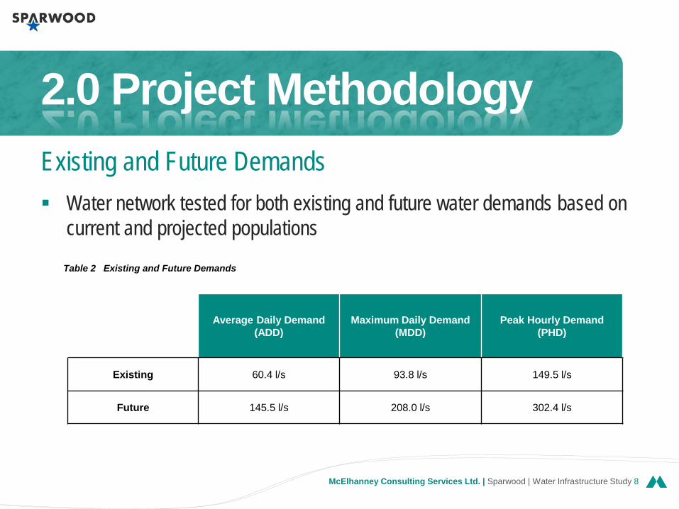
Water network tested for both existing and future water demands based on current and projected populations
2.0 Project Methodology Existing and Future Demands
Average Daily Demand (ADD)
Maximum Daily Demand (MDD)
Peak Hourly Demand (PHD)
Existing 60.4 l/s 93.8 l/s 149.5 l/s
Future 145.5 l/s 208.0 l/s 302.4 l/s
Table 2 Existing and Future Demands

v McElhanney Consulting Services Ltd. | Sparwood | Water Infrastructure Study 9
Water distribution analysis was completed using a water network computer model using WaterCAD© Version 8 software.
Several scenarios were tested for various areas of the District to evaluate current and future conditions and determine short-comings in the network.
Model verification was confirmed using static hydrant pressure data provided by the District. Total water demands were also compared with data provided by the District to confirm that total daily water demands calculated by the model were equivalent to actual recorded usages.
2.0 Project Methodology Water Model

v McElhanney Consulting Services Ltd. | Sparwood | Water Infrastructure Study 10
3 underground aquifer wells supply the District Water is pumped through two separate pump stations and distributed through the system to end users and
stored in two existing water storage tanks Water supply is currently non-chlorinated although fluoridation is added to natural amounts Main water supply wells on west side of the river Well #3 on east side of river has limited supply capacity Two wells on west side are sufficient New developments (Whiskey Jack, etc.) are now placing increased demands to provide additional water
and fire protection not currently available Present time, capable of providing fire protection for all single-family residential areas. Insufficient storage and some under sized pipes at critical locations resulting in the inability to provide fire
protection for commercial, institutional and industrial land uses to meet current Fire Underwriters Survey’s recommendations and the District’s target design criteria.
3.0 Existing Water System Evaluation
Existing System Overview

v McElhanney Consulting Services Ltd. | Sparwood | Water Infrastructure Study 11
Safe yield capacity for supply from the aquifer Wells #1 and #2 @ 6,500 m3/day Well #3 @ 3,270 m3/day Reservoir storage capacity Sparwood Proper – 2,300 m3 (2,300,000 litres) Sparwood Heights – 1,850 m3 (1,850,000 litres) Pumphouse capacity (Well #1 & #2) Well pump #1 – 3,250 m3/day (37.6 l/s) Well pump #2 – 3,900 m3/day (45.1 l/s) Well pump #3 – 3,270 m3/day (37.8 l/s) Booster pump #1 – 920 m3/day (10.6 l/s) Booster pump #2 – 6,500 m3/day (75.2 l/s) Booster pump # 3 (backup) – 2,670 m3/day (30.9
l/s)
Pumphouse capacity (Well #3) Well pump #3 – 3,200 m3/day (37.0 l/s) Booster pump #1 – 920 m3/day (10.6 l/s) Booster pump #2 – 6,500 m3/day (75.2 l/s) Booster pump #3 (backup) – 2,670 m3/day (30.9
l/s)
3.0 Existing Water System Evaluation
Existing System Performance: Water Supply

v McElhanney Consulting Services Ltd. | Sparwood | Water Infrastructure Study 12
Distribution System Existing community watermains were sized when
fire flow and daily usage were lower than today’s servicing standards
The computer model developed for the District’s water system incorporates all the existing piping network, supply pumps, reservoirs and PRV stations as they operate today, as depicted in Figure 3
Daily Water Supply Community water supply needs to meet the
demands of all users of the service. Water supply systems are evaluated based on the service demand types including: ADD, MDD, PHD, FF. (these are tested to confirm all service levels can be delivered)
Fire Protection Existing water network capable of providing max.
daily demand plus residential fire flow demands throughout the community.
However desire to support commercial and industrial developments triggers need to upgrade some facilities
Existing system cannot provide MDD to M.Creek; Teck/Joy; Whiskey Jack; and Sparwood Dr. areas
3.0 Existing Water System Evaluation
Existing System Performance: Others

v McElhanney Consulting Services Ltd. | Sparwood | Water Infrastructure Study 13
The District gets their water supply from an underground aquifer and this aquifer is capable of meeting the community’s water supply for full development as envisioned in the current OCP.
The Sparwood Proper pump station has limited capacity and all additional water supplies will come from Wells #1 and #2 in Pressure Zone 1207.
Watermains have recently been constructed within the Michel Creek area. During the detail design of these watermain, analysis was undertaken to confirm the watermain sizes that would deliver adequate demands at allowable pressures to the area. The transfer valve (PRV-1) will require decommissioning to increase the pressure in the Michel Creek area, as discussed earlier in this report.
Other key areas that have been specifically tested include the Sparwood Drive area at the south west entrance to the District where existing industrial developments are located and additional future industrial developments are contemplated.
Existing downtown area of Sparwood Proper was also reviewed in addition to a future industrial development located near the intersection of Highway 3 and Highway 43 (Teck/Joy Global industrial development see Figure 1). Finally, a large residential and resort development is proposed in the Whiskey Jack area (see Figure 1) was included in the analysis.
4.0 Future Water System Evaluation
Future System Overview

v McElhanney Consulting Services Ltd. | Sparwood | Water Infrastructure Study 14
Future Storage Tanks Future Distribution System
– Michel Creek Area – Sparwood Drive Area – Teck / Joy Global Area – Downtown Core Area – Whiskey Jack Area
4.0 Future Water System Evaluation
Future Water System Upgrades

v McElhanney Consulting Services Ltd. | Sparwood | Water Infrastructure Study 15

v McElhanney Consulting Services Ltd. | Sparwood | Water Infrastructure Study 16

v McElhanney Consulting Services Ltd. | Sparwood | Water Infrastructure Study 17

v McElhanney Consulting Services Ltd. | Sparwood | Water Infrastructure Study 18
Whiskey Jack Upgrade total = $3.4M
Option 1 – 1178 Storage Tank = $2.1M
Highway 3 Alignment = $2.0M
Option 2 – 1207 Storage Tank = $2.0M
5.0 Cost Estimates
Cost Estimates
Cost Summary
Phased Construction

v McElhanney Consulting Services Ltd. | Sparwood | Water Infrastructure Study 19
District’s computer model of their water system was updated and calibrated to allow realistic predictions of expected current and future water supply demand
Conclusions: – The wells are capable of delivering sufficient water to meet the community’s daily
demands and the tank storage is adequate to provide single-family residential fire flows everywhere in the community.
– The current system is only capable of providing fire protection equal to single-family residential demands throughout the community. There is insufficient storage and some under sized pipes at critical locations resulting in the inability to provide increased fire protection for commercial, institutional and industrial land uses.
– The Whiskey Jack area has developed to elevation 1170 m and cannot be expanded to any higher elevation without the installation of a pump station, supply pipeline and storage tank.
5.0 Conclusions
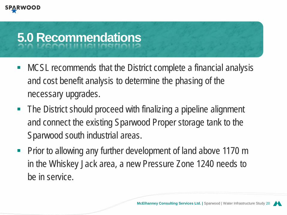
v McElhanney Consulting Services Ltd. | Sparwood | Water Infrastructure Study 20
MCSL recommends that the District complete a financial analysis and cost benefit analysis to determine the phasing of the necessary upgrades.
The District should proceed with finalizing a pipeline alignment and connect the existing Sparwood Proper storage tank to the Sparwood south industrial areas.
Prior to allowing any further development of land above 1170 m in the Whiskey Jack area, a new Pressure Zone 1240 needs to be in service.
5.0 Recommendations

v McElhanney Consulting Services Ltd. | Sparwood | Water Infrastructure Study 21
Thank You www.McElhanney.com

Questions