water for life and livelihoods
TRANSCRIPT

Water for life and livelihoods
Part 1: Anglian river basin district River basin management plan Updated: December 2015
LIT 10311
We are the Environment Agency. We protect and improve the environment and make it a better place for people and wildlife. We operate at the place where environmental change has its greatest impact on people’s lives. We reduce the risks to people and properties from flooding; make sure there is enough water for people and wildlife; protect and improve air, land and water quality and apply the environmental standards within which industry can operate. Acting to reduce climate change and helping people and wildlife adapt to its consequences are at the heart of all that we do. We cannot do this alone. We work closely with a wide range of partners including government, business, local councils, other agencies, civil society groups and the communities we serve. Contacts For more details about river basin management plans contact: Julie Foley, Area Manager Email: [email protected] You can also call the National customer contact centre: Anglian River basin management plan Bradmarsh Business Park, PO Box 544 Rotherham, S60 1BY 03708 506506 (local rate) Monday to Friday 8am to 6pm Published by: Environment Agency Horizon House Deanery Road Bristol BS1 5AH www.gov.uk/environment-agency
Further copies of this report are available on the river basin management plan web pages
(https://www.gov.uk/government/collections/river-basin-management-plans-2015). and via our National Customer Contact Centre: T: 03708 506506
Email: [email protected].
© Photo Copyright Norfolk Broads by Roger Green and licensed for reuse under this Creative Commons Licence
All rights reserved. This document may be reproduced with prior permission of the Environment Agency.
© Environment Agency 2016
Anglian river basin management plan. Part 1 2
Contents
Using the plan: accessing the most relevant information ................................................... 4 1. Introduction ..................................................................................................................... 5
1.1. The purpose of a river basin management plan .......................................................... 6 1.2. Who is responsible for implementing this plan ............................................................ 7 1.3. The Anglian river basin district .................................................................................... 9 1.4. Significant water management issues ....................................................................... 11 1.5. Working with others .................................................................................................. 13 1.6. Links to other major plans affecting water management ........................................... 15 1.7. Reporting progress on this plan ................................................................................ 16
2. Current state of the environment, environmental objectives and outcomes ............... 17 2.1. Current state of the environment .............................................................................. 18 2.2. Environmental objectives .......................................................................................... 20 2.3. Preventing deterioration ............................................................................................ 21 2.4. Protected area compliance and objectives ................................................................ 22 2.5. Water body objectives .............................................................................................. 26 2.6. Reversal of trends .................................................................................................... 30 2.7. Progressive reduction of pollution of groundwater .................................................... 30 2.8. Environmental outcomes for 2021 ............................................................................ 31
3. Measures to achieve the environmental objectives ...................................................... 34 3.1. Programme of measures: background ...................................................................... 35 3.2. Measures to prevent deterioration ............................................................................ 37 3.3. Main programmes of measures for 2021 outcomes .................................................. 49 3.4. Local measures ........................................................................................................ 60 3.5. Forward look at measures beyond 2021 ................................................................... 73 3.6. Additional measures to achieve protected area objectives ........................................ 78
4. Changes from 2009 to 2015 ............................................................................................. 80 4.1. Improvements in evidence ........................................................................................ 81 4.2. Measures implemented ............................................................................................ 83 4.3. Progress towards achieving the environmental objectives in the 2009 plan .............. 87
5. Summary statistics .......................................................................................................... 91
Anglian river basin management plan. Part 1 3

Using the plan: accessing the most relevant information The river basin management plan consists of a number of different documents, maps and datasets, of which this is just one. Below is a summary of the statutory components of the river basin management plan (in blue) along with associated documents and data sources outside of the official plan that support the plan (in brown):
Throughout this document there are light green boxes containing links to the further information relevant to each section.
•Current state and pressures on the environment. Environmental objectives, programme of measures and progress since 2009 plan (This document)
The plan - Part 1: River basin district
summary
•Summary of the technical, economic and engagement processes used to develop this plan. Referred to as 'Part 2: RBMP overview'
The plan - Part 2:Planning overview and additional information
•The flood hazards and risks, flood risk management objectives and the measures to achieve those objectives.
Flood risk management plan
•Throughout Part 1 and Part 2 documents there are links to interactive maps, detailed information and method statements that form part of the plan.
The plan:Maps, data and
supporting information
•The catchment data explorer is a web application to help explore and obtain detailed information about local catchments and individual bodies of water.
Catchment data explorer
Further information • You can access the river basin management plan and associated documents though the river
basin management web pages (www.gov.uk/government/collections/river-basin-management-plans-2015).
• A guide to accessing river basin management data and supporting information is available on the river basin management web pages (www.gov.uk/government/collections/river-basin-management-plans-2015).
Anglian river basin management plan. Part 1 4

This section provides an explanation of the purpose of this plan, who it is for and how the river basin district is managed.
1. Introduction
Anglian river basin management plan. Part 1 5

1.1. The purpose of a river basin management plan Water is essential for life and livelihoods. It allows the natural environment to flourish, and businesses, agriculture and the economy to grow and prosper.
Rivers, lakes, estuaries, coastal areas, wetlands and water under the ground provide many different benefits to society; from supplying drinking water and supporting fisheries to providing an essential resource for business and agriculture, transport routes and a source of recreation that promotes wellbeing.
It is critical that this precious resource is managed properly to ensure that the needs of society, economy and wildlife can be met and maintained over the long-term.
The purpose of a river basin management plan is to provide a framework for protecting and enhancing the benefits provided by the water environment. To achieve this, and because water and land resources are closely linked, it also informs decisions on land-use planning.
This plan contains 4 sets of information that groups who manage land and water should pay particular attention to:
• Baseline classification of water bodies - One of the main purposes of this plan is to prevent water bodies deteriorating. The first step to preventing deterioration is to understand the baseline status for all the quality elements in each water body. Deterioration from the baseline is not permitted, except in very specific circumstances that are described in this plan. Preventing deterioration is one of the biggest challenges in managing the water environment.
• Statutory objectives for protected areas - This plan highlights the areas of land and bodies of water that have specific uses that need special protection. These include waters used for drinking water, bathing, commercial shellfish harvesting and those that sustain the most precious wildlife species and habitats. The plan ensures that these areas have the legally binding objectives in place that protect those uses from potentially harmful activities and new developments.
• Statutory objectives for water bodies - This plan sets out legally binding objectives for each quality element in every water body, including an objective for the water body as a whole. The default objective is good status. Less stringent objectives have been set in some cases where natural conditions, technical feasibility or disproportionate cost make improvement impractical. The default deadline for achieving objectives is 2021. However, extended deadlines of 2027 or beyond have been set in some cases where it would be more appropriate, have less impact on existing activities or where the environment will need more time to respond to the planned measures.
• Summary programme of measures to achieve statutory objectives - This plan provides a framework for action and future regulation. To do this it summarises the existing mechanisms, both statutory and voluntary, that are used to manage the quality of the water environment. It also summarises the types of action and who needs to do this, to achieve the statutory objectives. Although it is not a detailed action plan it provides a clear signal to those who use and affect water about what they can do to make sure there is enough good quality water for life and livelihoods in England.
The river basin management plan has been approved by the Secretary of State for the Environment, Food and Rural Affairs. It has been prepared in line with Ministerial guidance and fulfils the requirements of the Water Framework Directive and contributes to the objectives of other EU directives. It is an update of and replaces the river basin management plan published in 2009 (referred to as the ‘2009 plan’ in this document).
Anglian river basin management plan. Part 1 6

1.2. Who is responsible for implementing this plan Many organisations are responsible for managing the water environment in the river basin district. These organisations are often grouped into sectors, such as water companies, agriculture and industry. Table 1 identifies these sectors and describes their role in managing the water environment.
The roles in managing the water environment are:
• Regulator - regulates and enforces the activities of operators
• Operator - undertakes activities that could potentially influence either directly or indirectly the quality of the water environment. Many of these activities are regulated.
• Influencer - educates, influences or advises others on how to reduce their impact on the water environment
• Undertakes projects - undertakes environmental improvement projects (for example, habitat restoration) to reduce the damage caused by others, usually in partnership with other groups
Table 1: Main sector groups involved in river basin management
Sector Role in managing the water environment
Regulator Operator Influencer Undertakes projects
Agriculture and rural land management - farming, forestry and horticulture X X X
Government and agencies:
Central government departments X X
Environment Agency X X X X
Natural England X X X X
Forestry Commission X X X
Marine Management Organisation X X
Highways England X X
Network Rail X X
Industry, manufacturing and other business - including chemicals, construction, food and drink, power generation, paper, textiles and metals
X
X
Internal drainage boards X X X X
Local government - includes local councils, national park authorities and Inshore Fisheries and Conservation Authorities
X X X X
Mining and quarrying - coal mining, non coal mining and quarrying X X
Anglian river basin management plan. Part 1 7

Sector Role in managing the water environment
Regulator Operator Influencer Undertakes projects
Navigation - inland waterways (Canal & River Trust), port and harbour authorities
X
X
X
X
Non-governmental organisations - user groups, catchment groups and environmental organisations (including local wildlife trusts and rivers trusts)
X X X
Waste treatment, transfer, storage and disposal - landfill, biowaste, waste treatment and transfer
X
Water industry - water supply and sewage treatment activities X X X X
Anglian river basin management plan. Part 1 8
1.3. The Anglian river basin district The Anglian river basin district (Figure 1) covers 27,900km2 and extends from Lincolnshire in the north to Essex in the south and from Northamptonshire in the west to the east Anglian coast.
In total over 7.1 million people live and work within the district and it includes the urban centres of Lincoln, Northampton, Milton Keynes and Chelmsford.
The Anglian river basin district has a rich diversity of wildlife and habitats, supporting many species of global and national importance. It is recognised as a rich region for wetland wildlife, with the Norfolk Broads being Britain’s largest nationally protected wetland and is important for wintering wildfowl.
There are 11 management catchments that make up the river basin district, which include many interconnected rivers, lakes, groundwater and coastal waters. These range from chalk and limestone ridges to the extensive lowlands of the Fens and East Anglian coastal estuaries and marshes.
The river basin district is a predominantly rural catchment, with more than 50% of land used for agriculture and horticulture. East Anglia is a tourist destination, particularly for water recreation including boaters, beach goers and anglers. The Norfolk Broads contributes significantly to the economy of the district.
To support economic growth and development, significant or large scale infrastructure projects will occasionally take place within the river basin district. These projects must take account of the environmental objectives within this river basin management plan. Similarly, the potential benefits and impacts of such projects will, where relevant, be considered during future reviews and updates of the plan, including updates to the environmental objectives.
Anglian river basin management plan. Part 1 9

Figure 1: Map of the Anglian river basin district
Anglian river basin management plan. Part 1 10
1.4. Significant water management issues The significant water management issues are the main issues that limit the uses and potential benefits of managing the water environment in the river basin district in a sustainable way. They have been identified based on the results of public consultation and assessments of the pressures caused by people now, in the past, and predicted in the future.
Many of these issues arise from current activities that provide a wide range of benefits. It may therefore not be possible or desirable to fully resolve the issues.
• Physical modifications - affecting 51% of water bodies in this river basin district
People have made many physical changes to rivers, lakes and estuaries, for example, flood defences and weirs, and changes to the size and shape of natural river channels for land drainage and navigation. These modifications alter natural flow levels, cause excessive build up of sediment in surface water bodies and the loss of habitats and recreational uses. In many cases the uses and associated physical modifications need to be maintained. In these circumstances it may not be possible to achieve good ecological status.
• Pollution from waste water – affecting 50% of water bodies in this river basin district
Waste water, or sewage, can contain large amounts of nutrients (such as phosphorus and nitrates), ammonia, bacteria, harmful chemicals and other damaging substances. It can enter water bodies where sewage treatment technology to remove enough of the phosphorus and harmful chemicals doesn’t exist, from leakages from privately owned septic tanks and, in wet weather, storm overflows can discharge untreated sewage having a significant impact on bathing waters. Population growth and changes in rainfall patterns are increasing the pressure on the sewer network.
• Pollution from towns, cities and transport - affecting 10% of water bodies in this river basin district
Rainwater draining from roofs, roads and pavements carries pollutants, including grit, bacteria, oils, metals, vehicle emissions, detergent and road salt drains to surface water, including estuaries and coastal waters. Many homes and workplaces have 'misconnected' drains, meaning that dirty water often enters surface waters and groundwater rather than foul sewer drains.
• Changes to the natural flow and level of water - affecting 10% of water bodies in this river basin district
Reduced flow and water levels in rivers and groundwater caused by human activity (such as abstraction) or less rainfall than usual that there is not enough water for people to use and wildlife might not be able to survive. Reduced flow affects the health of fish and exaggerates the impacts of barriers such as weirs. Climate change research shows that by 2050 England can expect significant seasonal variations, with higher winter and lower summer flows, and a reduction in flow overall. In the long term, there will be less water available to abstract for drinking, industry and irrigating crops.
• Negative effects of invasive non-native species - affecting 6% of water bodies in this river basin district
Invasive non-native species can have significant economic impacts. The cost of controlling invasive species to make sure that flood defences and the natural environment are not compromised is rising. American signal crayfish are becoming widespread and affect animals such as fish and invertebrates. Other species such as mitten crabs destroy habitats like reed beds and can cause banks to collapse by burrowing into them. Climate change is
Anglian river basin management plan. Part 1 11

thought to drive certain species northwards, increasing their frequency and variety in the future and affecting the condition of water bodies.
• Pollution from rural areas - affecting 47% of water bodies in this river basin district
Some approaches to land management have increased the amount of soils and sediment that are being washed off the land carrying phosphorus into waters which can cause excessive algae growth called 'eutrophication'. A changing climate means that more intense rainfall is likely to occur, increasing the risk of impacts further. Nitrate from fertilisers has built up in groundwater over decades and will take a long time to reduce. Sedimentation from erosion, forestry practices, saturated and compacted fields and livestock trampling on river banks has affected river ecology by smothering fish spawning grounds. Other impacts include bacteriological contaminations from animal faeces and inappropriately stored and applied livestock slurry being washed off the land, and pesticides from farming, forestry, golf courses and parks. These contaminants pose a particular threat to bathing waters, shellfish waters and drinking water.
Taking account of climate change The climate is changing as a result of greenhouse gas emissions caused by human activity. Latest UK climate projections show that temperatures will continue to rise, with increased winter rainfall and more rain falling in intense storms and continuing sea level rise. The impact on river flows, water quality and ecosystems is less clear. Studies to learn more about the effects of climate change on the river basin district are underway. In the meantime, it makes sense to implement measures that are flexible or increase resilience to extreme weather events and future warming.
Risk assessments Risk assessments are used to help identify significant water management issues by identifying where pressures could change in the future, potentially leading to a deterioration or reducing the effectiveness of measures to meet their objectives. The Environment Agency has reviewed and updated, where necessary, the risk assessments since the 2009 plan.
The risk assessments forecast risk up to 2027. Because of the relatively short timescale, the specific risks from climate change have been considered mainly in the faecal indicator organisms risk assessment and the abstraction-flow risk assessment.
Further information in this document • You can find a summary of the impacts of significant water management issues by sector in
section 5. Information elsewhere in the river basin management plan • You can find GeoPDF maps, statistics and main findings for each risk assessment on the
Environment Agency's ShareFile Service (https://ea.sharefile.com/d-sed90a482d5843d88). • More detail on risk assessments and links to the method statements behind them can be found
in section 4.4 of Part 2:RBMP overview (www.gov.uk/government/collections/river-basin-management-plans-2015).
• The Inventory of emissions, discharges and losses of priority and priority hazardous substances (https://ea.sharefile.com/d-sab675d1e4d74e5e8) provides information on priority substances at the river basin district scale.
• You can find more detail on how the inventory has been compiled in section 4.4 of Part 2: RBMP overview (www.gov.uk/government/collections/river-basin-management-plans-2015).
Sharefile links have been updated – please use the guide to accessing data and information to access files https://www.gov.uk/government/publications/river-basin-management-plans-accessing-data-and-information-guide
Anglian river basin management plan. Part 1 12

1.5. Working with others River basin district liaison panel The river basin district has a liaison panel. Members share their views as the representative of a sector that is responsible for implementing measures and carrying out projects.
The role of the liaison panel is to:
• contribute evidence to enable decision making and reporting on river basin management plans
• devise and track measures and projects as part of a programme of work to prevent deterioration and improve the environment
• work with members and their sectors to ensure a broad base for decision making and communication
• assist and champion the implementation of the catchment based approach
Catchment partnerships and the catchment based approach Taking a catchment based approach helps to bridge the gap between strategic management planning at river basin district level and activity at the local water body scale. The catchment based approach aims to encourage groups to work together more effectively to deal with environmental problems locally.
Catchment partnerships are groups of organisations with an interest in improving the environment in their local area and are led by a catchment host organisation. They inform the river basin management planning process and help implement measures by:
• providing local evidence
• targeting and coordinating action
• identifying and accessing funding for improvements in the catchment
• incorporating river basin management planning into the wider environmental management of the catchment
Some of the partnerships will produce their own catchment or local plans. The partnerships work on a wide range of issues including, but not restricted to, the water environment and river basin management. Catchment partnerships also cover coastal and marine waters.
Table 2 lists the partnerships in this river basin district. Some partnership groups are in the early stages of being set up, while others have been active for years. Members from some catchment partnerships also sit on the river basin district liaison panel.
Anglian river basin management plan. Part 1 13

Table 2: Catchments and partnership groups
Catchment Partnership group host Broadland Rivers Norfolk Rivers Trust
Cam and Ely Ouse (including South Level)
Anglian water
Combined Essex Essex Wildlife Trust
East Suffolk Essex and Suffolk Rivers Trust and The Rivers Trust
Nene River Nene Regional Park Community Interest Company
North Norfolk Norfolk Rivers Trust
North West Norfolk Norfolk Rivers Trust
Old Bedford including the Middle Level
Cambridgeshire Action in communities in rural England (ACRE)
Upper and Bedford Ouse Bedfordshire Rural Communities Charity
Welland Welland Rivers Trust and the Environment Agency
Witham Lincolnshire Rivers Trust
Incorporating information from others in river basin management planning Some organisations have asked for the opportunity to share their environmental data to help improve river basin management and catchment planning. For example, sharing data and information to improve local evidence on the cause of a problem, such as the reason for not achieving good status, or a new response to a problem. The Environment Agency is working with the Catchment Based Approach National Support Group and others to confirm data sharing priorities. To learn more about sharing your information contact your local catchment partnership, see further information box.
Further information in this document • You can find a map showing the location and boundaries of the catchments in section 3.4.
• Contact details for the catchment partnerships as well as a summary of the measures they are carrying out can be found in section 3.4.
Information elsewhere in the river basin management plan • You can find more information about the catchment based approach in section 3.4 of Part 2:
RBMP overview (www.gov.uk/government/collections/river-basin-management-plans-2015).
Supporting information • You can find more information on the liaison panel and details about membership in the Record
of consultation and engagement (www.gov.uk/government/collections/river-basin-management-plans-2015).
• You can find examples on how the Environment Agency has used information from others in the consultation response document (www.gov.uk/government/collections/river-basin-management-plans-2015).
• You can find more information on the catchment based approach on the catchment based approach web pages (http://www.catchmentbasedapproach.org/).
Anglian river basin management plan. Part 1 14
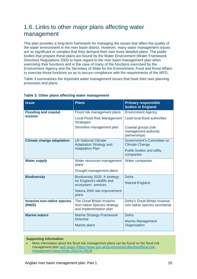
1.6. Links to other major plans affecting water management This plan provides a long-term framework for managing the issues that affect the quality of the water environment in the river basin district. However, many water management issues are so significant or complex that they demand their own more detailed plans. The public bodies that prepare these plans are bound by the Water Environment (Water Framework Directive) Regulations 2003 to have regard to the river basin management plan when exercising their functions and in the case of many of the functions exercised by the Environment Agency and the Secretary of State for the Environment, Food and Rural Affairs to exercise those functions so as to secure compliance with the requirements of the WFD.
Table 3 summarises the important water management issues that have their own planning processes and plans.
Table 3: Other plans affecting water management
Issue Plans Primary responsible bodies in England
Flooding and coastal erosion
Flood risk management plans
Local Flood Risk Management Strategies Shoreline management plan
Environment Agency
Lead local flood authorities
Coastal groups (risk management authority partnerships)
Climate change adaptation UK National Climate Adaptation Strategy and Adaptation Plan
Government’s Committee on Climate Change
Public bodies and utility companies
Water supply Water resources management plans
Drought management plans
Water companies
Biodiversity Biodiversity 2020: A strategy for England’s wildlife and ecosystem services
Natura 2000 site improvement plans
Defra
Natural England
Invasive non-native species (INNS)
The Great Britain Invasive Non-native Species strategy and implementation plan
Defra’s Great Britain invasive non-native species secretariat
Marine waters Marine Strategy Framework Directive
Marine plans
Defra
Marine Management Organisation
Supporting information: • More information about the flood risk management plans can be found on the flood risk
management plan web pages (https://www.gov.uk/government/collections/flood-risk-management-plans-frmps-2015-to-2021).
Anglian river basin management plan. Part 1 15
1.7. Reporting progress on this plan A formal assessment of progress with meeting the objectives in this plan will be reported in the 2021 update to this plan. An interim report on making measures operational will be produced and reported to the European Commission in 2018.
The Environment Agency and other organisations have extensive monitoring programmes to assess the state of the water environment. To help monitor progress with this plan and show how the quality of the water environment is changing, the Environment Agency will report on a range of quality indicators. These could include:
• status or risks facing protected areas: drinking water protected areas, Natura 2000 sites, bathing waters, shellfish waters, nutrient sensitive areas
• ecological status plus individual status of some quality elements: fish, macrophytes, invertebrates, diatoms, phosphorous, dissolved oxygen, ammonia, specific pollutants, acidity
• chemical status plus individual status of some quality elements
• the annual change in status of each of the individual ecological status elements. This will be used as an indicator of overall progress towards good ecological status
As well as monitoring the state of the environment, the Environment Agency also plans to report on important activities that will eventually bring positive results. For example:
• numbers of fish passage improvements
• length of shoreline and river bank habitat enhancements
• area of priority habitat created or improved
• extent of new mitigation measures implemented on heavily modified and artificial water bodies
Those implementing measures should monitor and report their own progress. The following groups will be particularly important:
• catchment partnerships - progress on partnership projects, progress on securing additional funding and influencing others
• water companies - progress on implementing national environment programme schemes and other measures that relate to environmental performance agreed by the water company with their customer challenge group
• agriculture and rural land managers - progress on uptake of Countryside Stewardship schemes that benefit water and other sector related initiatives, for example, Campaign for the Farmed Environment
• local authorities - opportunities taken to encourage growth by green infrastructure and habitat enhancement
• ports and navigation authorities - implementing mitigation measures
• Highways England - progress on environmental aspects of their £15 billion road investment strategy
The liaison panel, as a collective group representing the river basin district as a whole, provides an opportunity for monitoring progress against the plans, sharing best practice and helping catchment partnerships. As such, positive actions taken by partners to implement this plan can be reported and collated through the panels.
Anglian river basin management plan. Part 1 16

This section describes the current state of the environment and the environmental objectives for the river basin district. It also describes the planned progress towards achieving those objectives by 2021.
2. Current state of the environment, environmental objectives and outcomes
Anglian river basin management plan. Part 1 17

2.1. Current state of the environment The WFD indicator of the health of the water environment is whether a water body is at good status or potential. This is an assessment of a range of quality elements relating to the biology and chemical quality of surface waters and quantitative and chemical quality of groundwater. To achieve good ecological status or potential, good chemical status or good groundwater status every single element assessed must be at good status or better. If one element is marginally below its threshold for good status, then the whole water body’s status is classed as less than good.
Surface water bodies can be classed as high, good, moderate, poor or bad status. Table 4 gives a description of each of those status classes.
Table 4: Definition of status in the Water Framework Directive
Table 5 shows the number of water bodies in the river basin district. It shows whether these are natural, artificial (such as canals and reservoirs) or have been modified ('heavily modified') for particular uses.
Table 5: Number of water bodies in the river basin district
Water body categories Natural Artificial Heavily modified
Total
Rivers, canals and surface water transfers 189 44 293 526 Lake 10 19 17 46 Coastal 4 1 8 13 Estuarine 3 0 15 18 Groundwater 31 0 0 31 Total 237 64 333 634
Status Definition
High Near natural conditions. No restriction on the beneficial uses of the water body. No impacts on amenity, wildlife or fisheries.
Good Slight change from natural conditions as a result of human activity. No restriction on the beneficial uses of the water body. No impact on amenity or fisheries. Protects all but the most sensitive wildlife.
Moderate Moderate change from natural conditions as a result of human activity. Some restriction on the beneficial uses of the water body. No impact on amenity. Some impact on wildlife and fisheries.
Poor Major change from natural conditions as a result of human activity. Some restrictions on the beneficial uses of the water body. Some impact on amenity. Moderate impact on wildlife and fisheries.
Bad Severe change from natural conditions as a result of human activity. Significant restriction on the beneficial uses of the water body. Major impact on amenity. Major impact on wildlife and fisheries with many species not present.
Anglian river basin management plan. Part 1 18

Tables 6 and 7 summarise the current status of surface and groundwater water bodies in the river basin district.
Table 6: Ecological and chemical 2015 classification for surface waters
Ecological status or potential Chemical status
No. of water bodies Bad Poor Mod Good High Fail Good
603 13 106 419 65 0 7 596
Table 7: Chemical and quantitative 2015 classification for groundwaters
Quantitative status Chemical status
No. of water bodies Poor Good Poor Good
31 16 15 15 16
The 2015 water body classification is the baseline from which deterioration is not permitted unless certain and specific conditions apply.
A summary of the current state of protected areas is included in section 2.4.
Information elsewhere in the river basin management plan • For more information on how the current status of the water environment is assessed see
section 4 of Part 2: RBMP overview (www.gov.uk/government/collections/river-basin-management-plans-2015).
• You can access GeoPDF maps showing the current status of water bodies on the Environment Agency’s ShareFile Service (https://ea.sharefile.com/d-sed90a482d5843d88).
• To obtain the 2015 classification results for each water body, download the water body spreadsheet (https://ea.sharefile.com/d-s0faa355450243538).
Sharefile links have been updated – please use the guide to accessing data and information to access files https://www.gov.uk/government/publications/river-basin-management-plans-accessing-data-and-information-guide
Anglian river basin management plan. Part 1 19

2.2. Environmental objectives The environmental objectives of the WFD are:
• to prevent deterioration of the status of surface waters and groundwater
• to achieve objectives and standards for protected areas
• to aim to achieve good status for all water bodies or, for heavily modified water bodies and artificial water bodies, good ecological potential and good surface water chemical status
• to reverse any significant and sustained upward trends in pollutant concentrations in groundwater
• the cessation of discharges, emissions and loses of priority hazardous substances into surface waters
• progressively reduce the pollution of groundwater and prevent or limit the entry of pollutants
Environmental objectives have been set for each of the protected areas and water bodies in the river basin district. They were identified through a process involving technical and economic appraisals and formal public consultation. Achieving the objectives will optimise the benefits to society from using the water environment.
The environmental objectives summarised in this section are legally binding. All public bodies must have regard to these objectives when making decisions that could affect the quality of the water environment.
In certain specific circumstances, exemptions from some of these objectives may be applied. These exemptions are considered in the process used to set these objectives.
Information elsewhere in the river basin management plan • You can find more information on the process of setting objectives in section 5 of Part 2: RBMP
overview (www.gov.uk/government/collections/river-basin-management-plans-2015).
Anglian river basin management plan. Part 1 20

2.3. Preventing deterioration To protect the many uses and benefits the water environment provides it is essential to prevent it deteriorating. The water industry and many of the businesses essential to the economy have invested billions of pounds in infrastructure that rely on secure supplies of clean water. Preventing deterioration also protects wildlife and people’s health and wellbeing.
The requirement to prevent deterioration was taken into account when setting the water body status objectives. Each water body status objective in this plan is set no lower than the 2015 classification result for the water body. This applies to a water body's overall status and to the status of each element used in classification.
Section 3 contains a summary of the programmes of measures to protect and improve the beneficial use of the water environment in the river basin district. Without these measures, the quality of the water environment would deteriorate with associated loss of benefits. It is estimated that without these controls, 55% of surface waters in the river basin district would deteriorate by 2027 due mainly to an increase in the unmitigated physical modification of rivers and the spread of invasive non-native species. The increase in physical modification is driven by climate change and population growth resulting in the need for increased flood protection, land drainage, and the spread of urban areas.
An assessment of whether deterioration has occurred from the 2015 classification baseline will be carried out in 2021.
Further information in this document • You can find an assessment of whether deterioration in water body status occurred between
2009 and 2015 in section 4.3. Information elsewhere in the river basin management plan • You can find information on preventing deterioration in section 3.1 of Part 2: RBMP overview
(www.gov.uk/government/collections/river-basin-management-plans-2015).
Anglian river basin management plan. Part 1 21

2.4. Protected area compliance and objectives There are many areas where the water environment is especially valued. These areas include rare wildlife habitats, bathing waters and areas where drinking water is abstracted. These areas are known as ‘protected areas’ and their uses are given particular legal protection. Protected areas are a priority for action to make sure they achieve their objectives and protect the benefits they provide.
This section presents information on the extent to which protected areas are compliant with their current standards and objectives.
Drinking water protected areas The objectives for drinking water protected areas are to ensure that:
• under the water treatment regime applied, the drinking water produced meets the standards of the Drinking Water Directive plus any UK requirements to make sure that drinking water is safe to drink
• the necessary protection to prevent deterioration in the water quality in the protected area in order to reduce the level of purification treatment required
These objectives are at risk when increasing pollution levels caused by human activity could lead to more treatment being needed in the future and where measures are needed to reduce pollution. For groundwater bodies only, not meeting these objectives may also mean the water body is classed as poor chemical status. Safeguard zones are non statutory areas identified for ‘at risk’ abstractions where land use management practices and other activities can affect the quality of the untreated water. Measures to prevent and reduce pollution are targeted within these zones.
Table 8: Drinking water protected areas current status and at risk
Water body type Number of drinking water protected areas
Number ‘at risk’ Number at poor chemical status for drinking water protected area objectives
Surface water 37 31 Does not apply to surface waters
Groundwater 31 15 7
Economically significant species (shellfish waters) Some areas of estuarine and coastal waters are designated as shellfish waters. Shellfish waters are areas requiring protection or improvement to support shellfish life and growth in order to contribute to the high quality of shellfish for people to eat.
Table 9: Shellfish water protected areas current status and objectives
Number of shellfish waters
Objective Number currently achieving objective
Achieving objective by 2015
Achieving objective by 2021
Achieving objective by 2027
23 <300 E.coli/100ml in
the shellfish flesh and intravalvular
fluid
3 6 1 16
Anglian river basin management plan. Part 1 22

Recreational waters (bathing waters) Bathing waters are designated waters and beaches that large numbers of bathers use. The objective for bathing waters is to preserve, protect and improve the quality of the environment and to protect human health by meeting the ‘sufficient’ water quality standards of the Bathing Waters Directive and to take such realistic and proportionate measures considered appropriate with a view to increasing the number of bathing waters classified as 'excellent' or 'good'.
Table 10: Bathing water protected areas current status and objectives
Number of bathing waters
Objective Number which met at least the sufficient classification in 2014*
Number expected to achieve at least sufficient in 2015
Number at risk of not achieving sufficient in 2015
38 At least sufficient classification 37 37 1
* This is the number that would have met at least the sufficient class if the new 2015 standards had been in force
Nutrient sensitive areas (Nitrate vulnerable zones) The objective of the Nitrates Directive is to reduce water pollution caused by nitrates from agricultural sources and to prevent further such pollution occurring. Nitrate Vulnerable Zones (NVZs) are designated where nitrate concentrations in water bodies are high or increasing, or water bodies are, or may become, eutrophic due to agricultural nitrate pollution. Farmers within NVZs must comply with mandatory action programme measures to reduce agricultural nitrate losses. In addition, a code of good agricultural practice has been established for voluntary implementation by all farmers.
Table 11: Nitrate vulnerable zone protected areas extent
Reason for designation Number of NVZs
Land area(ha) covered by NVZ type
% of RBD covered by NVZ type
High nitrate in surface water 99 2,103,668 84
High nitrate in groundwater 16 1,277,309 51
Eutrophication in lakes or reservoirs 8 71,167 3
Eutrophication in estuaries or coastal waters 0 - 0
Anglian river basin management plan. Part 1 23

Nutrient sensitive areas (Urban Waste Water Treatment Directive) The objective of the Urban Waste Water Treatment Directive is to protect the environment from the adverse effects of waste water discharges. Sensitive areas are designated for water bodies affected by eutrophication or where surface water abstraction is affected by elevated nitrate concentrations. Reductions or emission standards for nutrients in sewage effluent must be met within areas sensitive to nutrient pollution.
Table 12: Urban Waste Water Treatment Directive protected areas type and extent
Reason for designation Number of sensitive areas
Length (km)/Area (km2) designated
Eutrophication in rivers 23 1482
Eutrophication in canals N/A N/A
Eutrophication in lakes or reservoirs 13 33.56
Eutrophication in estuaries or coastal waters N/A N/A
High nitrate in surface fresh water 6 581
Natura 2000 sites: Water dependent Special Areas of Conservation or Special Protection Areas The overall objective of the Habitats Directive is to maintain or restore, at favourable conservation status, natural habitats and species of wild fauna and flora of community importance. The network of protected areas established under the Wild Birds and Habitats Directives is known as Natura 2000. Site conservation objectives are designed to maintain or restore Natura 2000 sites to favourable conservation status. The provisions of the WFD only relate to water dependent Natura 2000 sites or water dependent habitats and species on sites that combine wet and dry features. The objective is to protect and, where necessary, improve the water environment to achieve favourable conservation status for the water dependent features for which the site was designated as set out in the site’s conservation objectives.
Natural England determines what favourable conservation status means in terms of the environmental conditions (targets) and ecology expected for designated habitats and species. The targets required are based on UK Common Standards Monitoring Guidance (CSMG), published by the Joint Nature Conservation Committee. Some of the conservation objectives for attributes of Natura 2000 sites are the same or equivalent to objectives for elements of water bodies. Natural England monitors compliance with these objectives. Where there are CSMG targets for flow and water quality elements, they have been taken into account when setting water body status objectives. Where the deadline for achieving Natura 2000 water body objectives (CSMG target) has been extended beyond 2021, the Environment Agency has agreed interim goals locally with Natural England.
Ramsar sites are wetland sites of international importance. For the purposes of river basin management planning, Ramsar sites are considered in the same way as Natura 2000 sites.
Anglian river basin management plan. Part 1 24
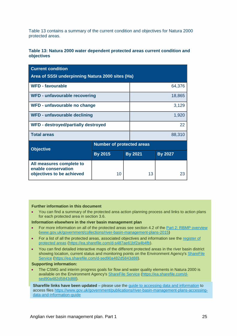
Table 13 contains a summary of the current condition and objectives for Natura 2000 protected areas.
Table 13: Natura 2000 water dependent protected areas current condition and objectives
Current condition
Area of SSSI underpinning Natura 2000 sites (Ha)
WFD - favourable 64,376
WFD - unfavourable recovering 18,865
WFD - unfavourable no change 3,129
WFD - unfavourable declining 1,920
WFD - destroyed/partially destroyed 22
Total areas 88,310
Objective Number of protected areas
By 2015 By 2021 By 2027
All measures complete to enable conservation objectives to be achieved 10 13 23
Further information in this document • You can find a summary of the protected area action planning process and links to action plans
for each protected area in section 3.6. Information elsewhere in the river basin management plan • For more information on all of the protected areas see section 4.2 of the Part 2: RBMP overview
(www.gov.uk/government/collections/river-basin-management-plans-2015) • For a list of all the protected areas, associated objectives and information see the register of
protected areas (https://ea.sharefile.com/d-s487ae61bf2a4b4fb). • You can find detailed interactive maps of the different protected areas in the river basin district
showing location, current status and monitoring points on the Environment Agency's ShareFile Service (https://ea.sharefile.com/d-sed90a482d5843d88).
Supporting information: • The CSMG and interim progress goals for flow and water quality elements in Natura 2000 is
available on the Environment Agency's ShareFile Service (https://ea.sharefile.com/d-sed90a482d5843d88).
Sharefile links have been updated – please use the guide to accessing data and information to access files https://www.gov.uk/government/publications/river-basin-management-plans-accessing-data-and-information-guide
Anglian river basin management plan. Part 1 25

2.5. Water body objectives For surface waters, objectives are set for ecological and chemical status. For artificial or heavily modified water bodies, objectives are set for ecological potential and chemical status. For groundwater, objectives are set for quantitative and chemical status.
Water body objectives consist of 2 pieces of information: the status (for example, good) and the date by which that status is planned to be achieved (for example, by 2021).
The status part of an objective is based on a prediction of the future status that would be achieved if technically feasible measures are implemented and, when implemented, would produce more benefits than they cost. The objective also takes into account the requirement to prevent deterioration and achieving protected area objectives.
The date part of an objective is the year by which the future status is predicted to be achieved. The date is determined by considering whether the measures needed to achieve the planned status are currently affordable, and once implemented, the time taken for the ecology or the groundwater to recover.
Aiming to achieve good status or potential by 2021 is the default objective for this plan. Where certain and specific conditions apply, alternative objectives (to good status by 2021) have been set. These either involve taking an extended time period to reach the planned status (for example, good by 2027) or aiming to achieve a lower status (for example, moderate by 2015).
The water body objectives in this plan are:
• ‘x’ status by 2015: 2015 status matches the predicted future status or potential. Here the predicted future status has already been achieved and no further improvement in status is expected. The main environmental objective is to prevent deterioration in status between 2015 and 2021.
• ‘x’ status by 2021: there is confidence that, as a result of the programme of measures, the water body will improve from its 2015 status or potential to achieve the predicted future status by 2021.
The ‘by 2015’ date has been used to clearly distinguish water bodies and elements where the reported 2015 status matches the predicted future status (and so no further improvement is expected) from water bodies and elements where an improvement from the reported 2015 status is required to achieve the predicted future status by 2021.
• ‘x’ status by 2027: the deadline for achieving the status or potential has been extended to 2027. Where the time extension is due to ecological or groundwater recovery time, there is confidence that the measures needed to achieve the improvement in status are already in place or will be in place by 2021. Where the time extension is due to practical constraints delaying implementation of the measures, there is confidence the process of implementing the measures will begin before 2021. For the remaining objectives with a 2027 date, there is currently not enough confidence that the improvement in status can be achieved by an earlier date.
• ‘x’ status by 2040 or ‘x’ status by 2050 or ‘x’ status by 2060: the deadlines for achieving the planned status or potential have only been extended beyond 2027 where either ecological recovery time or groundwater recovery time will delay the achieving of the planned status. In these cases there is confidence that the measures needed to achieve the improvement in status are already in place or will be in place by 2021.
Where the status is less than good, this means that a less stringent objective has been set.
Anglian river basin management plan. Part 1 26

The following two tables summarise the status objectives for water bodies, indicating how many of these are alternative objectives.
Table 14 summarises the ecological and chemical status objectives that have been set for the 603 surface water bodies in the river basin district. It shows for instance, that:
• 257 water bodies have an objective of maintaining or aiming to achieve good ecological status between 2015 and 2027 (or beyond)
• 268 water bodies have already achieved their objective of moderate ecological status (a less stringent objective)
• 37 water bodies have been set an objective of reaching moderate ecological status (a less stringent objective) by 2027 (an extended deadline)
Table 14: Summary of ecological status or potential and chemical status objectives for surface water bodies (number of water bodies) including those with less stringent objectives and extended deadlines (blue shaded cells)
Ecological status or potential Chemical status Bad Poor Mod Good High Total Fail Good Total
By 2015 3 30 268 65 0 366 1 596 597 By 2021 0 1 6 14 0 21 0 0 0 By 2027 0 1 37 176 0 214 0 6 6 Extended
deadline Beyond 2027 0 0 0 2 0 2 0 0 0
Total 3 32 311 257 0 603 1 602 603
Less stringent Less stringent
Anglian river basin management plan. Part 1 27

Table 15 summarises the quantitative and chemical status objectives that have been set for the 31 groundwater water bodies in the river basin district. It shows for instance, that:
• 26 water bodies have an objective of maintaining or aiming to achieve good quantitative status between 2015 and 2027
• 18 water bodies have an objective of maintaining or aiming to achieve good chemical status between 2015 and 2027
• 5 water bodies have already achieved their objective of poor quantitative status (a less stringent objective)
Table 15: Summary of quantitative and chemical status objectives for groundwater (number of water bodies) including those with less stringent objectives and extended deadlines (blue shaded cells)
Quantitative status Chemical status Poor Good Total Poor Good Total
By 2015 5 15 20 13 16 29 By 2021 0 3 3 0 0 0 By 2027 0 8 8 0 2 2 Extended
deadline Beyond 2027 0 0 0 0 0 0
Total 5 26 31 13 18 31
Less stringent Less
stringent
Although 57% of water bodies have a less stringent objective for ecological status or potential, only 14% of elements have a similar objective. The difference is because the overall objective’s status is determined by the lowest of the element level objectives. Therefore for many of the water bodies with a less stringent objective, most of the elements still have an element level objective of good status.
Anglian river basin management plan. Part 1 28

Justification for alternative objectives Table 16 shows how many times the different reasons for justifying the setting of alternative objectives (extended deadlines and less stringent objectives) were used across all water bodies (surface water and groundwater) in this river basin district. More than one reason may have been used to justify the alternative objective for any particular water body and therefore the numbers in the table do not equal the total number of water bodies.
The table also shows the reasons extended deadlines have been set for some shellfish waters and Natura 2000 protected areas.
Table 16: Summary of the justifications for alternative objectives for water bodies, shellfish waters and Natura 2000 protected areas
Alternative objective reason Sub-reason
Number of water bodies or protected areas where reason has been used Water bodies
Natura 2000
Shellfish waters
Technically infeasible
No known technical solution is available 177 4 0
Cause of adverse impact unknown 48 8 0
Practical constraints of a technical nature 8 22 41
Number of water bodies or protected areas where technically infeasible has been used
230 23 41
Disproportionately expensive
Unfavourable balance of costs and benefits 191 0 16
Disproportionate burdens 386 5 0
Number of water bodies or protected areas where disproportionately expensive has been used
471 5 16
Natural conditions
Ecological recovery time 32 0 0
Groundwater status recovery time 5 0 0
Background conditions 31 0 0
Number of water bodies or protected areas where natural conditions has been used
61 0 0
Total number of water bodies or protected areas with an alternative objective (extended deadline and/or less stringent status objective)
543 23 57
Anglian river basin management plan. Part 1 29

2.6. Reversal of trends Actions to reverse any significant and sustained upward trends in pollutant concentrations in groundwater must be implemented as soon as a trend has been identified. It is not possible to propose an alternative that is less stringent or extend the deadline for this objective.
2.7. Progressive reduction of pollution of groundwater Hazardous substances must be prevented from entry into groundwater and the entry into groundwater of all other pollutants must be limited to prevent pollution. Hazardous substances means substances or groups of substances that are toxic, persistent and liable to bioaccumulate, and other substances or groups of substances which give rise to an equivalent level of concern.
Information elsewhere in the river basin management plan • More information on alternative objectives, including explanations of the justifications for
alternative objectives can be found in section 5.4 and 5.5 of Part 2: RBMP overview (www.gov.uk/government/collections/river-basin-management-plans-2015).
• A GeoPDF map of the types, location, boundaries, monitoring sites and current status of water bodies in the river basin district is available on the Environment Agency’s ShareFile Service (https://ea.sharefile.com/d-sed90a482d5843d88).
• The current status and objective for each water body is available in a spreadsheet on the Environment Agency’s ShareFile service (https://ea.sharefile.com/d-s0faa355450243538).
Sharefile links have been updated – please use the guide to accessing data and information to access files https://www.gov.uk/government/publications/river-basin-management-plans-accessing-data-and-information-guide
Anglian river basin management plan. Part 1 30

2.8. Environmental outcomes for 2021 To help determine the water body status objectives summarised earlier, a prediction was made about what the status of each element will be in 2021. Predicted improvements in status are based on measures where there is confidence that the:
• measures will happen by 2021
• location of the measures and the water bodies that will benefit are known
• change in element status will occur as a result of the measures
Confidence in this context means there is at least a reasonable expectation (more confident than not) that the measures will happen and the outcome will be met. Environmental processes are complex and investment plans of both public and private sectors change. Some of the predicted outcomes may therefore not be achieved. However, there will be opportunities to implement additional measures and potentially achieve further outcomes by 2021. These opportunities are discussed in section 3.5.
The water body status objective does not always show whether an improvement in status is predicted to occur by 2021. For example, an element or water body may require an extended deadline to reach good status and so have an objective of ‘good by 2027’. However, it might be predicted to improve from poor to moderate status by 2021.
To help understand the improvements predicted to occur as a result of measures in this plan, the tables 17, 18 19 and 20 summarise the current status and the predicted status in 2021 for:
• surface water bodies (ecological and chemical status)
• groundwater (quantitative and chemical status)
• all elements for all surface water bodies in the river basin district
• selected elements that contribute to the ecological status of surface waters
Table 17: Current and predicted 2021 ecological and chemical status of surface water bodies (number of surface water bodies)
Ecological status Chemical status
Bad Poor Mod Good or better Fail Good
Current status 13 106 419 65 7 596
Predicted 2021 status 10 95 419 79 7 596
Predicted change -3 -11 0 14 0 0
Table 18: Current and predicted 2021 quantitative and chemical status of groundwater bodies (number of groundwater bodies)
Quantitative status Chemical status
Poor Good Poor Good
Current status 16 15 15 16
Predicted 2021 status 13 18 15 16
Predicted change -3 3 0 0
Anglian river basin management plan. Part 1 31

Table 19: Current and predicted 2021 status of ecological elements and chemical elements (number of elements in surface water bodies)
Ecological status Chemical status
Bad Poor Mod Good or better Fail Good
Current status 66 349 589 3,186 8 911
Predicted 2021 status 62 306 572 3,240 8 911
Predicted change -4 -43 -17 54 0 0
The predicted status in 2021 for all of the classified elements for each water body are available in a comprehensive data set that forms part of this plan. Table 20 summarises the current and predicted 2021 status for biological elements in surface waters.
Table 20: Current and predicted 2021 status for biological elements in rivers (number of times element assessed)
Bad Poor Mod Good
or better
Fish Current status 9 62 65 78
Predicted 2021 status 7 53 68 86
Predicted change -2 -9 3 8
Invertebrates Current status 6 25 115 304
Predicted 2021 status 6 24 110 310
Predicted change 0 -1 -5 6
Plants
(macrophytes and
phytobenthos)
Current status 3 56 116 83
Predicted 2021 status 3 52 107 86
Predicted change 0 -4 -9 3
Further information in this document: • Further summaries of current status, 2021 predicted outcomes and water body objectives are
presented in section 5. Information elsewhere in the river basin management plan: • The 2021 predicted outcomes for each water body are available to download on the
Environment Agency’s ShareFile service: (https://ea.sharefile.com/d-s0faa355450243538).
Sharefile links have been updated – please use the guide to accessing data and information to access files https://www.gov.uk/government/publications/river-basin-management-plans-accessing-data-and-information-guide
Anglian river basin management plan. Part 1 32
Additional environmental outcomes for 2021 For some measures, although there is confidence that the measure will happen by 2021, there is not enough confidence about the location or the scale of improvement to be able to predict outcomes for specific elements in specific water bodies.
These additional 2021 outcomes, which are not included in the tables above, are:
• Improvements to protected areas such as the quality of raw water at 78 safeguard zones due to actions targeting pesticides and bathing water quality as a result of 2 water company improvements to waste water discharges.
• Improvements in river ecology in at least 8 water bodies due to habitat improvements, for example the Foot Meadow project in Northampton. The creation or improvement of over 1,628ha of wetland and 40km of river as a result of flood risk management schemes such as through the Great Fen project.
• Improvements in fish populations, including eels, in at least 25 water bodies, for example the River Glaven, as a result of habitat and fish passage work. A reduction in the presence of non-native invasive species as a result of 6 projects within the river basin district.
• Reductions in inputs of sediment, phosphate and bacteria resulting in better river ecology in several catchments, for example, where Countryside Stewardship is adopted; urban run-off improvements in Lincoln, Grantham and Peterborough; and nutrient reductions from 21 sewage treatment works.
• Improvements to the flow of rivers as a result of the Restoring Sustainable Abstraction programme.
The environmental objectives in this plan will drive additional improvement in the water environment by 2021. Opportunities include the periodic review of water company price limits in 2019, government spending reviews, major infrastructure projects and the routine review of environmental permits.
Supporting information: • To see a summary of the effects of this plan on the wider environment read the strategic
environmental assessment (www.gov.uk/government/collections/river-basin-management-plans-2015).
• The impact assessment for the river basin management plans in England provides further information on the benefits this plan will achieve. It is available on the river basin management plan web pages (www.gov.uk/government/collections/river-basin-management-plans-2015).
Anglian river basin management plan. Part 1 33

This section provides a summary of the programme of measures that are needed to manage the significant water management issues and achieve the objectives of this plan. The benefits of action and those involved are identified.
3. Measures to achieve the environmental objectives
Anglian river basin management plan. Part 1 34

3.1. Programme of measures: background This section provides a summary of the programmes of measures used to achieve the environmental objectives of this plan.
Table 21 provides an overview of the summary programmes of measures.
Table 21: Overview of the programme of measures
Measures to prevent deterioration
Summary of the programmes of measures to control the significant water management issues
These ongoing measures play a significant role in preventing deterioration.
They protect all the current uses of the water environment and the benefits that society gets from it.
The ongoing measures represent substantial investment and all sectors with an interest in the water environment have a role to play.
These measures apply across the river basin district.
Section 3.2
Measures to achieve outcomes by 2021
Main programmes of measures for 2021 outcomes
(Summary of the programmes of measures that will improve the water environment by 2021)
The main programmes have discrete funding streams to deal with particular issues.
These programmes will achieve the biggest improvements in the water environment by 2021.
They include the measures predicted to improve specific water bodies by 2021 and additional measures where it has not been possible to predict the geographic extent and/or size of environmental change they will result in by 2021.
These measures apply in either specific locations or across the river basin district.
Section 3.3
Local measures (Summary of the local measures identified by catchment partnerships)
Each catchment partnership has identified the measures they will implement by 2021.
Some of the measures are reflected in water body specific outcomes by 2021.
These measures apply within specific catchments.
Catchment partnerships also identify what more they could achieve if additional resources could be realised in future.
Section 3.4
Anglian river basin management plan. Part 1 35

Forward look at measures beyond 2021
Summary of the programmes of measures to meet objectives for water bodies with extended deadlines
A summary of the additional measures needed to achieve objectives beyond 2021.
These will be reviewed when the plans are next updated in 2021.
These measures are not linked to predicted outcomes for 2021.
Section 3.5
Additional measures to achieve protected area objectives
Summary and links to the action plans containing measures for protected areas
A summary of and links to the action plans to meet protected area objectives in specific locations.
Section 3.6
Many of these measures, for example, land-based controls on pollutants, will also lead to improvements in marine waters not covered by the WFD.
Information elsewhere in the river basin management plan • You can find a summary of the process for identifying of measures, including how costs and
benefits were assessed in section 5 of the Part 2: RBMP overview (www.gov.uk/government/collections/river-basin-management-plans-2015
• More information about the mechanisms used to implement measures is available on the Environment Agency’s ShareFile service (https://ea.sharefile.com/d-sabbd14301a44d5e9).
Sharefile links have been updated – please use the guide to accessing data and information to access files https://www.gov.uk/government/publications/river-basin-management-plans-accessing-data-and-information-guide
Anglian river basin management plan. Part 1 36

3.2. Measures to prevent deterioration This section summarises the ongoing measures that help prevent deterioration and protect the many uses of the water environment and the benefits it provides. Many of these measures also help improve the quality of the water environment.
The measures are presented for each of the significant water management issues described in section 1.4.
To identify which sectors are involved in implementing the measures, the main roles in managing the water environment (identified in section 1.2) are referred to below.
Physical modifications Physical changes such as widening, deepening and straightening rivers, estuaries and coasts help to meet the needs of society and the economy. Physical modifications allow the water environment to be used and valued for many purposes, including for navigation, flood risk management, fishing and other recreational activities that improve people's wellbeing and quality of life. These changes have helped towns and cities to develop and the economy to grow, but this can sometimes be at the expense of the water environment.
There are benefits to controlling new modifications and reducing the impacts of existing ones. While many modifications are, and will continue to be important to society, their potentially harmful impacts can be reduced and the resilience of aquatic communities improved. Taking action to address the impacts of physical modifications can have benefits for protected areas, in particular Natura 2000 sites. There is increasing evidence that in some cases, addressing the impacts of modifications (for instance by using natural water retention measures such as wetland creation and coastal realignment) could help alleviate flooding as well as slowing flows and making more space for water.
How the issue is managed Regulators and operators use and apply relevant legislation and policy:
• Local government and internal drainage boards grant land drainage consents under the Land Drainage Act 1991. Government and agencies (Environment Agency) grant flood defence consents under the Water Resources Act 1991. Subject to parliamentary approval, flood defence consents will be replaced with flood risk activity permits from April 2016. All these authorities assess applications for schemes or activities for their potential effect on local flood risk and the environment.
• Government and agencies (Environment Agency) make sure new abstraction and impoundment licences and environmental permits include protection for freshwater and migratory fish where relevant and use powers to ensure fish passes and screens are in place where appropriate.
• Government and agencies (Marine Management Organisation) use marine licensing controls under the Marine and Coastal Access Act 2009 for activities including construction, alteration or improvement works, dredging and removing substances or objects from the sea or sea bed.
• All sectors to consider the Marine Policy Statement and marine plans in decisions that affect marine and coastal environments. These plans set out the strategic framework for sustainable development of the sea.
• Navigation (harbour authorities) license dredging and works within harbour limits.
Anglian river basin management plan. Part 1 37

• Government and agencies (Environment Agency) work with partners and interested groups to identify appropriate mitigation measures to achieve WFD objectives in Artificial and Heavily Modified Water Bodies. Mitigation measures are practicable steps that can be taken to mitigate adverse impacts from beneficial human activities such as impoundments for water resources, or structures that provide flood defence.
• Local government consider impact on hydromorphology when preparing spatial plans and local flood risk management plans, decisions on development management, new buildings and infrastructure.
Operators and project undertakers apply the following guidance:
• Navigation (ports and harbours), industry, manufacturing and other business, non governmental organisations and central government use the e-learning site for flood risk management to access expert information on mitigation measures.
• All sectors apply the Environment Agency’s WFD compliance guidance, which covers a range of activities in estuaries and coasts.
• Industry, manufacturing and other business use the Environment Agency’s 'Hydropower development: guidance for run-of-river hydropower'.
• Navigation (ports and harbours), government and agencies (Environment Agency) and local government use industry developed best practice guidance.
Influencers and regulators consider future management activities: • Local government, central government (Environment Agency) refresh the
strategic overview of sea flooding and coastal erosion to better manage environmental risk in the long term using shoreline management plans.
• Government and agencies (Environment Agency) to explore effectiveness of existing approach to planning guidance on development in flood plains and coastal erosion risk areas.
• Government and agencies (Environment Agency) to review flood defence design standards for WFD and Natura 2000 sites.
• Government and agencies (Environment Agency) to carry out feasibility studies and designs for flood storage areas for environmental benefits.
Further information in this document • Section 3.3 includes further information on flood risk management investment. Information elsewhere in the river basin management plan • You can find more information about managing flooding and flood risk management plans in
section 2 of the Part 2: RBMP overview (www.gov.uk/government/collections/river-basin-management-plans-2015).
Supporting information • More information on marine plans can be found on the gov.uk webpages
(www.gov.uk/government/collections/marine-planning-in-england). • The Environment Agency’s compliance guidance for activities in estuaries and coasts can be
found on the gov.uk webpages (www.gov.uk/government/publications/complying-with-the-water-framework-directive-marine-dredging).
• The Environment Agency’s guidance for hydropower development can be found on the gov.uk webpages (www.gov.uk/government/collections/hydropower-schemes-guidelines-and-applying-for-permission).
Anglian river basin management plan. Part 1 38

Managing pollution from waste water Waste water, or sewage, can contain:
• nutrients such as phosphorus and nitrates
• harmful chemicals, including ammonia and metals and those used in homes and industry
• other harmful substances, including viruses and bacteria
Pollutants in waste water can affect the dissolved oxygen levels within the receiving waters and can impact on ecology. Nutrients can disturb the natural ecological balance of a water body and cause excessive growth of vegetation and algae, which may starve the water of oxygen. Other pollutants such as metals and everyday chemicals used in products around the home which are discharged in sewage waste water may be directly toxic to plants or animals. Humans can also be affected, for example, through chemicals that accumulate in food or bacteria and viruses in waste water affecting bathing waters. Reducing the impact of pollution from waste water will provide many benefits and help support a wide range of water uses that society values. These uses include drinking water supply, agriculture (including commercial shellfish harvesting), water sports, angling, conservation, and wider benefits such as tourism and quality of life. Addressing pollution from waste water will have benefits for a large number of protected areas including bathing waters, shellfish waters, Natura 2000 sites and sensitive areas under the Urban Waste Water Treatment Directive. It also benefits marine waters under the Marine Strategy Framework Directive.
How the issue is managed Regulators, operators and influencers use and apply relevant legislation and policy:
• Government and agencies (Environment Agency) grant and review environmental permits under the Environmental Permitting Regulations (England and Wales) 2010 to the water industry, manufacturing and other business and other sectors to protect the environment from pollutants such as chemicals, nutrients, bacteria, viruses, ammonia and organic material in discharged effluent.
• Government and agencies (Environment Agency) work with the water industry to develop a long-term strategy for sewerage to prevent deterioration of permitted discharges (for example, combined sewer overflows), resulting from pressures such as climate change, growth and ageing infrastructure; and to develop a long term strategy to reduce and minimise risks to the water environment from misconnected sewerage (foul sewage wrongly connected to surface water).
• Government and agencies (Environment Agency) grant environmental permits for small sewage discharges in designated sensitive areas. In other areas, small sewage discharges (including septic tanks) are exempt from the need for a permit if they can meet a number of criteria.
• Government (Environment Agency) to carry out a review of areas sensitive to eutrophication, in relation to the Urban Waste Water Treatment Directive (UWWTD) and make recommendations to Defra.
• Government and agencies (Environment Agency and Health and Safety Inspectorate) enforce restrictions and bans on the use of certain chemicals.
Anglian river basin management plan. Part 1 39

• Local government considers the impact on water quality in their preparation of spatial plans, decisions on spatial planning, development management, new buildings and infrastructure.
• All sectors to consider the Marine Policy Statement and marine plans in decisions that affect marine and coastal environments. These plans set out the strategic framework for sustainable development of the sea.
Further information in this document • You can find more information on water company investment in section 3.3.
Information elsewhere in the river basin management plan • You can find more information on the National Environment Programme in Section 2 of Part
2: RBMP overview (www.gov.uk/government/collections/river-basin-management-plans-2015).
Anglian river basin management plan. Part 1 40

Managing pollution from towns, cities and transport Rainwater draining from roads and pavements carries many pollutants. These include metals, vehicle emissions, silt, grit, bacteria from animal faeces and oil. Other issues arise from pollution from households and business, for example, misuse of the drainage network. Pollution can enter surface water sewers that discharge to rivers, estuaries and coastal waters, causing harm to animals and plants.
Dealing with pollution from towns, cities and transport is a complex task. Costs for the measures tend to be higher and ownership of the problem is less clear. Existing legal powers are designed to address specific sources of pollution rather than small-scale or cumulative impacts from many different sources. However, there are some ways in which the challenge can be addressed. Benefits from action include improved flood resilience, climate change adaptation, increased biodiversity and social cohesion. In addition, protected areas, particularly certain bathing waters and shellfish waters, can be improved when enough resources are targeted at a specific issue.
How the issue is managed Regulators and operators use and apply relevant legislation and policy:
• Local government uses planning conditions, legal agreements and enforcement powers under the Town and Country Planning Act 1990 to prevent or stop pollution from developments, roads and other infrastructure.
• Local government makes sure that new developments address potential pollution problems by using sustainable drainage systems to manage surface water.
• Local government uses powers under the Building Act 1984 to rectify misconnected waste water pipe work, and statutory nuisance powers under the Environmental Protection Act 1990 to stop water pollution from unauthorised operations such as transient car wash operations.
• Government and agencies (Environment Agency) use anti-pollution works powers (including service of notices) under the Water Resources Act 1991 to prevent or clean up small scale pollution, for example, ensuring storage tanks are bunded or repairing misconnections.
• Industry, manufacturing and other business comply with existing regulations (for example, the Environmental Permitting (England and Wales) Regulations 2010) to make sure that chemicals are properly managed and surface water drainage is appropriately used and maintained.
Operators take action, where appropriate: • Industry, manufacturing and other business (construction industry) use
sustainable drainage systems to remove silt and minimise other chemicals to prevent polluting run-off.
• Local government considers urban diffuse pollution pressures when developing spatial plans, determining planning applications and designing and constructing local authority owned buildings, infrastructure and grounds. These should incorporate sustainable drainage schemes and water efficiency measures where practical and affordable.
• Local government incorporates green and blue infrastructure into regeneration schemes where possible.
Anglian river basin management plan. Part 1 41

Further information in this document • You can find more information on Highways England’s environment fund in section 3.3.
• Local government and industry, manufacturing and other business reduce the impact of pesticides by using Amenity Assured registered weed control contractors under the Voluntary Initiative.
Regulators and operators plan and work together:
• Government and agencies (Environment Agency) and Highways England apply the memorandum of understanding agreement covering the strategic road network and remediation of high risk outfalls.
• Government and agencies (Environment Agency) and urban and transport (Network Rail) operate under the terms of a memorandum of understanding covering contaminated land, water discharge and use of pesticides.
• Government and agencies (Environment Agency and water industry) investigate and deal with misconnections, for example, through the National Misconnections Strategy group and in accordance with Defra’s diffuse urban action plan.
• All sectors to consider the Marine Policy Statement and marine plans in decisions that affect marine and coastal environments. These plans set out the strategic framework for sustainable development of the sea.
• Industry manufacturing and other business, local government, navigation and general public follow codes of conduct and non-statutory estuary and coastal management plans to protect and improve the water environment in specific locations.
• Local government works with industry, manufacturing and other business (Local Enterprise Partnerships), and non governmental organisations (catchment partnerships and Local Nature Partnerships) to develop joint improvement programmes.
• Industry, manufacturing and other business (Local Enterprise Partnerships) work in partnership with all sectors to help identify where money from the European Growth Programme is invested to develop local economies and enhance the environment.
Anglian river basin management plan. Part 1 42

Changes to natural flow and levels of water Taking too much water from freshwater or tidal rivers, canals, lakes and groundwater damages the environment. Changes in the natural flow and level of water could affect some Natura 2000 sites; particularly water dependent Special Areas of Conservation. Improving the way water resources are managed will make sure that there is enough good quality water for a healthier water environment and secure supplies of water for people, businesses and agriculture. It will also provide more leisure opportunities and increase the amenity value of natural environments, leading to health benefits for people.
How the issue is managed Regulators and operators use and apply relevant legislation and policy:
• Government and agencies (Environment Agency) grant licences under the Water Resources Act 1991 to regulate how much water is taken from rivers, lakes estuaries and groundwater. The Environment Agency reviews the sustainability of time-limited abstraction licences as they expire and the licence holders seek replacement licences. The Environment Agency will take action to curtail time-limited licences that are not sustainable. Replacement licences are granted on a sustainable basis in line with water body objectives.
• Government and agencies (Environment Agency) change or revoke permanent licences to protect the environment from actual or potential damage, including serious damage under the Water Resources Act 1991.
• Government and agencies (Environment Agency) work to bring a number of currently exempt abstraction activities into regulation following public consultation and formulation of government policy and legislation. This includes dewatering, transfers for inland navigation and previously exempt irrigation activities. Some reductions in currently exempt abstractions that are causing serious damage to the environment may be necessary. This may result in an improvement in groundwater and flow in affected water bodies.
• All sectors consider the Marine Policy Statement and marine plans in decisions that affect marine and coastal environments. These plans set out the strategic framework for sustainable development of the sea.
Regulators and operators take action:
• Government and agencies (Environment Agency) identify water resource pressures due to abstraction and restore sustainable flows and groundwater levels through changes to abstraction licences and physical changes to river channels to improve flows. New licences must be sustainable and prevent future impacts.
• Government and agencies (Environment Agency) implement the Restoring Sustainable Abstraction (RSA) programme. This programme identified, investigated and is solving environmental risks or problems caused by unsustainable licensed water abstraction. The Environment Agency takes action to curtail abstraction licences that have been identified as causing an environmental problem under the RSA programme. The Environment Agency aims to complete the programme by the end of March 2020.
Anglian river basin management plan. Part 1 43

Regulators and operators plan and work together: • Water industry complete statutory Water Resource Management Plans, setting out
how supplies and demand for water will be managed over a 25 year period, and takes action to restore sustainable groundwater and flows where impacts due to abstraction have been confirmed.
• Water industry produce drought plans to make sure that public water supplies are maintained while minimising the environmental impact of drought.
• Government and agencies (Environment Agency) produce abstraction licensing strategies to help ensure a consistent approach to managing water resources and balancing the needs of water users and the environment.
• Government and agencies (Environment Agency) revoke unused licences where the licence holder does not have a reasonable need for the water.
• Water industry carries out Adaptive Management trials, to determine the best measures for improving heavily modified water bodies used for water supply.
Regulators, operators, influencers and project undertakers make sure water is used efficiently:
• All sectors take up or encourage water efficiency measures, including water industry work on metering, leakage, audits, providing water efficient products, promoting water efficiency and education.
• Local government sets out local plan policies requiring new homes to meet the tighter water efficiency standard of 110 litres per person per day as described in Part G of Schedule 1 to the Building Regulations 2010.
• Industry manufacturing and other business implement tighter levels of water efficiency, as proposed by changes to the Building Regulations.
• Agriculture and rural land management manage demand for water and use water more efficiently to have a sustainable water supply for the future.
• Local government commissions water cycle studies to inform spatial planning decisions around local water resources.
Further information in this document • You can find more information on water resources sustainability measures and water
company investment in section 3.3. Information elsewhere in the river basin management plan
• You can find more information about the management of abstraction and flow in Part 2: RBMP overview (www.gov.uk/government/collections/river-basin-management-plans-2015).
Anglian river basin management plan. Part 1 44

Managing invasive non-native species Some non-native animals and plants are invasive and can have significant social, economic and environmental impacts. Where they lead to greater erosion some plants, such as Himalayan balsam, can increase flood risk. Others like American signal crayfish can decrease river bank stability and most have negative impacts on ecology and leisure activities such as angling and water sports. There are also significant costs in controlling and safely disposing of invasive species such as Japanese knotweed on development sites and managing species such as zebra mussels, which can block pipes, intakes and other structures.
Many invasive non-native species spread rapidly and once they are established control is often prohibitively expensive or technically infeasible and ultimately unsuccessful.
The approach to dealing with invasive non native species is set out in the GB Invasive Non-native Species Strategy. The strategy aims to minimise the risk posed by, and reduce the negative impacts of invasive non-native species. It adopts a hierarchical approach stressing prevention, followed by early detection and rapid response and finally long-term management and control.
The most effective and least expensive measure is to reduce the number of new species introduced and slow the spread of those that are already present by applying good biosecurity (measures which reduce the risk of spreading diseases and invasive non-native plants and animals) and promoting the 'Check, Clean Dry' and ‘Be Plantwise’ campaigns.
Natura 2000 protected areas can be vulnerable to certain invasive non-native species. Intensive and often expensive control measures may be required to actively manage or eradicate them in specific circumstances. For example, at sites designated for their wetland habitat interest, Himalayan balsam can dominate and reduce the habitat space available for native plant species. Controlling the Himalayan balsam by targeted and intensive hand pulling or cutting over a number of years can reduce the pressure from this species and prevent further deterioration of the habitat.
How the issue is managed Regulators and operators use and apply relevant legislation and policy:
• Government and agencies (Environment Agency and Natural England) use the Keeping and Introduction of Fish Regulations 2015 and Wildlife and Countryside Act 1981 to control movements of invasive non-native species. A change in legislation, implemented in April 2014, introduced a ban on selling 5 high-risk plant species including water primrose and floating pennywort.
• Agriculture and rural land management is aware of the Wildlife and Countryside Act 1981 and does not allow certain species to escape into the wild.
• Government and agencies (Marine Management Organisation) use policies within emerging marine plans and marine policy statements to support controlling and mitigation against invasive non native species.
• Government and agencies implement EU Regulation 1143/2014 on Invasive Alien Species. Implementation of the regulation is gradual and will take place throughout the period of this plan.
Regulators, operators, influencers and project undertakers plan and work together:
Anglian river basin management plan. Part 1 45

• Government and agencies (includes Environment Agency and Natural England), non governmental organisations (including angling, conservation and recreation) implement the updated Great Britain strategy on invasive species, which includes species impact risk assessments, action plans and rapid response.
• All sectors work together to develop and implement codes of practice to reduce the spread of invasive non-native species.
Regulators, operators, influencers and project undertakers take action:
• Government and agencies (includes Environment Agency and Defra), non governmental organisations (angling, conservation and recreation) and navigation implement rapid responses to contain and eradicate new invasions where practicable. This measure is aided by the addition of powers to make Species Control Agreements and Orders in the Wildlife & Countryside Act 1981 as amended by the Infrastructure Act 2015.
• Government and agencies (Natural England) manage invasive non-native species at selected protected sites as appropriate.
• All sectors can form Local Action Groups to deal with invasive non native species and raise awareness.
Regulators, operators, influencers and project undertakers build awareness and understanding:
• Government and agencies (includes Environment Agency and Natural England), non-governmental organisations (including angling, conservation and recreation), local government and navigation work in partnership to influence recreational users to slow the spread of invasive non-native species by promoting 'Check, Clean, Dry' actions.
• Government and agencies (Defra) and all sectors raise public awareness of the risk of transferring non-native species accidentally and of preventative approaches.
• Central government helps the non-native species secretariat co-ordinate alert systems, species records and a central repository for information, including public online and smart phone submission of species records.
Information elsewhere in the river basin management plan • You can find more information about the management of invasive non-native species in section
2 of Part 2: RBMP overview (www.gov.uk/government/collections/river-basin-management-plans-2015).
Supporting information • The GB Invasive Non-native Species Strategy can be found on the GB non-native species
secretariat webpages (www.nonnativespecies.org/index.cfm?sectionid=55).
Anglian river basin management plan. Part 1 46

Manage pollution from rural areas Pollution from rural areas comes from the combined effects of numerous sources, including agriculture, roads, recreational land use such as golf courses and forestry activities. It is mainly caused by nutrients, contaminants, chemicals such as pesticide and sediment entering water bodies and groundwater as a result of land management activities.
Dealing with pollution from rural areas will help society reap the benefits of a healthy water environment. Farmers will benefit from making sure soil and nutrients are retained on the land rather than losing them, through run-off, to water. Controlling this run-off will help reduce localised flooding, reduce the sedimentation of lakes and harbours, and improve fisheries and reduce the amount of harmful chemicals entering water bodies. Water companies will spend less money treating water for colour, pesticides and nitrate contamination. A reduction in nutrients will also benefit water quality and habitat in estuaries and coastal waters.
A wide range of protected areas will see benefits, including bathing water, shellfish waters, drinking water protected areas, Natura 2000 sites and nutrient sensitive areas designated as nitrate vulnerable zones.
How the issue is managed Regulators and operators use and apply relevant legislation and policy:
• Government and agencies (Environment Agency) check and ensure compliance against environmental permits under the Environmental Permitting (England and Wales) Regulations 2010 and against requirements of a wide range of environmental legislation.
• Agricultural and rural land management (farm businesses) comply with permits granted under the Environmental Permitting (England and Wales) Regulations 2010. Permitted activities include some discharges to groundwater, spreading of waste to land for agricultural benefit, pig and poultry units over a certain size and safe recovery of agricultural waste.
• Agricultural and rural land management (farm businesses) comply with the action programme measures within the Nitrate Pollution Prevention Regulations 2015 in all nitrate vulnerable zones.
• Agricultural and rural land management (farm businesses) comply with the requirements of the Control of Pollution (Silage Slurry and Agricultural Fuel Oil) Regulations 2010 (SSAFO).
• Agricultural and rural land management (farm businesses) ensure that polluting matter is not present at a place where it has or is likely to enter controlled waters to avoid enforcement action under Water Resources Act 1991.
• Government and agencies (Farming Advice Service) advise farmers on general requirements of cross compliance and regulations required under the WFD.
• Government and agencies (Environment Agency and Natural England) provide site-level advice on the specific requirements of regulations.
• Government and agencies (Natural England) provide advice on the specific requirements of regulation that relate to designated sites, and can prevent or stop potentially damaging activities.
Anglian river basin management plan. Part 1 47

• Government and agencies (Environment Agency and Natural England) provide advice and training to farmers in some priority catchments through an approach such as Catchment Sensitive Farming.
• Government and agencies (Environment Agency) review the effectiveness of measures within catchments and, where there is sufficient need, consider whether further action should be proposed.
• Government and agencies (Forestry Commission) comply with the UK Forestry Standard, the government’s approach to sustainable forestry.
• Local government uses planning conditions, legal agreements and enforcement powers under the Town and Country Planning Act 1990 to prevent or stop pollution from rural developments, roads and other rural infrastructure.
• Local government considers the impact of pollution when preparing spatial plans, minerals and waste plans and making decisions on development management, new rural buildings and rural infrastructure.
Operators, influencers and project undertakers take action: • Agricultural and rural land management (farm businesses) meet cross
compliance requirements of the Basic Payment scheme funded by the Common Agricultural Policy.
• Agricultural and rural land management (farm businesses) voluntarily participate in Countryside Stewardship and Countryside Productivity schemes to prevent deterioration, improve water quality and reduce flood risk.
• Agricultural industry manufacturing and other business participate in sector led approaches including farm assurance and the Campaign for the Farmed Environment schemes.
• Water industry and rural land management work together in drinking water safeguard zones to reduce the need for water treatment as a result of nutrients or pesticides to meet drinking water standards.
• Government and agencies (Forestry Commission and Environment Agency) use opportunity mapping to identify and promote locations where woodland creation can achieve multiple benefits for the environment.
Further information in this document • You can find more information on Countryside Stewardship in section 3.3.
Information elsewhere in the river basin management plan • You can find more information about the management of pollution from rural areas in section
2 of Part 2: RBMP overview (www.gov.uk/government/collections/river-basin-management-plans-2015).
Anglian river basin management plan. Part 1 48

3.3. Main programmes of measures for 2021 outcomes This section provides a summary of the main programmes of measures, grouped by funding sources, which will improve the water environment by 2021. The outcomes of these measures fall into 2 categories:
• measures which the predicted improvements in the status of water bodies by 2021 are based upon
• measures which will happen by 2021 and achieve environmental outcomes, but there is not enough confidence (in location or scale of improvement) to predict specific outcomes
The main programmes are: • water company investment programme
• Countryside Stewardship
• Highways England’s environment fund
• flood risk management investment programme
• catchment level government funded improvements
• water resources sustainability measures
Supporting information • You can find a list of the measures used to predict improvements in status by 2021 for
specific elements in specific water bodies, and a summary of the measures expected to result in additional environmental outcomes for 2021 on the Environment Agency’s ShareFile service (https://ea.sharefile.com/d-sabbd14301a44d5e9).
Sharefile links have been updated – please use the guide to accessing data and information to access files https://www.gov.uk/government/publications/river-basin-management-plans-accessing-data-and-information-guide
Anglian river basin management plan. Part 1 49

Water company investment programme
Ofwat, the economic regulator of the water companies reviews water industry investment plans every 5 years. As part of this process, known as the price review, the Environment Agency works with water companies, Ofwat and others to make sure that investment protects the water environment, increases resilience and secures long-term benefits for society and the economy. The Environment Agency sets out the environmental obligations, including work required to prevent deterioration and achieve protected area and water body status objectives. Across England and Wales, water companies will be investing £3.5 billion in environmental improvements between 2015 and 2020. This equates to, when forecast over a 37-year period, a total of approximately £410 million being invested in this river basin district.
Significant investment will go into addressing point source impacts from sewage treatment works and discharges from the sewer network. This will reduce pollutants such as ammonia and nutrients that disturb the natural ecological balance of water bodies and cause excessive growth of vegetation and algae. Further investment will deal with abstraction and flow pressures. This includes reducing the amount of water that can be taken or measures to enhance habitats to compensate for damage caused by abstraction. Habitat improvement schemes are planned to reduce the impact of physical modifications caused by water company operations and action is planned to deal with invasive non-native species on water company land. Further measures will ensure compliance with the Eels Regulations, which require water intakes to be screened to prevent eels and other fish from being drawn out of the river into drinking water treatment works. Climate change adaptation and mitigation is an integral part of water company planning and is an essential part of assessing scheme options. This is particularly important for water resources planning, where water companies must plan up to 25 years in advance to make sure that there is enough water to meet future demands. Most of the measures are well-established engineering solutions that are proven to be effective. Changes are secured through amendments to environmental permits. There are some catchment and habitat improvement schemes that are less well established, including measures to reduce pesticide pollution. Some of these schemes rely on voluntary behavioural change affecting agricultural practice. These can be less effective when compared to engineering solutions. A 'fair share approach' is applied to the selection of measures, which assumes there is a proportional reduction in polluting load from each of the contributing sectors. For example, when identifying measures for phosphorus in a catchment, the amount coming from sewage treatment works and the amount from other sources, such as rural diffuse pollution was calculated. If the sewage works was responsible for 70% of the phosphorus load, then the measure identified is to achieve 70% of the required phosphorus reduction. In this situation achieving an improvement in status is reliant on other sectors putting additional measures in place.
Water company investment will directly contribute to predicted improvements in status by 2021 for specific elements in specific water bodies. A large proportion of this will be achieved by installing phosphate-stripping equipment at sewage treatment works. In addition, measures to reduce the amount of water taken out of the environment for public water supply will make sure that there is enough water left in rivers and lakes to support good ecological status. This will be achieved through changes to water company abstraction licences.
Anglian river basin management plan. Part 1 50
A wide range of measures will secure additional outcomes for the environment, but are not linked to specific improvements in element status by 2021 because there is insufficient confidence about the scale of improvement. This includes measures for eel passage, measures to protect drinking waters and improve bathing waters and measures to improve river habitat and flow regime where it is affected by impoundment for public water supply. Water companies are also investing in the Chemicals Investigation Programme, a multi-million study to better understand the impacts of chemicals in treated sewage and to trial new treatment technologies and catchment measures to reduce these impacts. The results from the Chemicals Investigation Programme will be used to implement measures to reduce the impacts of chemicals discharged in sewage in the future.
Examples of these measures in the Anglian river basin district
Water resources The Trinity Broads, a special area of conservation (SPA), are located in east Norfolk and comprise of 5 interconnected shallow lowland lakes, including Ormesby, Ormesby Little, Rollesby, Lady and Filby Broads. Essex and Suffolk Water abstraction from Ormesby Broad was identified as having the potential to significantly affect the hydrology of the Broads and, therefore, impact on the condition of the water-dependent designated features. Asset management plan (AMP) investigations concluded that while the Broad water inflows and outflows were balanced, a minimum Broad water depth of 30cm was not maintained across the extent of the Broads in a drought year, thus presenting a risk to the water-dependent designated features.
East and Suffolk Water have identified a programme of mud pumping at Trinity Broads to mitigate the impact of its abstraction. The company plans to remove sediment from the Broad to ensure that this minimum water depth is maintained, and, therefore, the designated features are protected. It has also had 2 cessation levels added to its abstraction licence (a more restrictive condition while mud pumping is carried out, and a less restrictive condition once mud pumping is complete) to ensure that the site is protected while this work takes place. The previous licence had no cessation level associated with the Broad. The company is also prioritising the mud pumping to those areas that need it the most.
Water quality Rising in eastern Cambridgeshire, the East Anglian River Stour forms the county boundary between Suffolk and Essex. Flowing through characteristic lowland English countryside, the river is at the heart of the Dedham Vale Area of Outstanding Natural Beauty, made world famous by the artists Constable and Gainsborough. As part of the nationally significant strategic water transfer supplying Essex, the river is the main source for Abberton Reservoir Special Area of Conservation (SAC), and flows into the Stour Estuary Special Protection Area (SPA) and Essex Estuaries SAC. Following on from phosphorus removal investment under the Urban Waste Water and Habitats Directives, the next tranche of investment will address continued eutrophication, particularly in the upper and middle reaches of the catchment. The proposed investment at a further 5 Anglian Water Services assets is predicted to reduce the proportion of river length at poor or bad phosphorus status from over 50% to less than 10%, and improve a further 30% (over 70km) to good status.
Anglian river basin management plan. Part 1 51

Countryside Stewardship
Countryside Stewardship is a new scheme that is open to all eligible farmers, woodland owners, foresters and other land managers through a competitive application process. It is entirely voluntary and is part of a wider investment of £3.5 billion in England under the Common Agricultural Policy for 2016 to 2020. It will contribute £900 million of new funds to enhance the natural environment, particularly the diversity of wildlife and water quality. Of this funding, about £400 million will be invested over a 5-year period to improve water quality and increase resilience against flooding.
By 2020, it is expected that 30% to 40% of rural England could be part of a Countryside Stewardship agreement. Countryside Stewardship supports the implementation of measures over and above legal requirements and good practice. It will address soil management and reduce the effect of nutrients, sediment and faecal contamination. This will reduce the impact of eutrophication and benefit bathing waters, shellfish waters and drinking water. This is achieved through measures categorised by the following groups:
• enhanced field management, including seasonal livestock exclusion, winter cover crops, buffer and riparian management strips next to watercourses and reduced nutrient applications from fertilisers
• land use change, including woodland and wetland creation or converting arable land to grassland which requires less fertiliser
• water and woodland capital grants, including sediment traps, fencing of watercourses and tree planting
• re-naturalising rivers and coast defences, including making space for water and coastal realignment
Countryside Stewardship will support climate change resilience, for example, by planting trees next to rivers and streams, which can reduce river temperature and the risk to salmonid fisheries. It will also reduce sedimentation of rivers, making rivers better able to store more flood water.
Individually these measures can be effective at a field scale but a number of land managers need to take up measures across the whole catchment for the measures to be really effective. As a result, improvements to the environment from Countryside Stewardship are not linked to specific improvements in water body element status by 2021. The uptake of measures is voluntary, with the first agreements commencing in January 2016.
The individual nature of catchments including soils, topography and rainfall make it difficult to quantify the benefits of these measures. Countryside Stewardship is expected to achieve additional environmental outcomes for 2021. Preliminary research suggests that for nutrients and sediment it may provide elemental improvements of approximately 2 to 10% from the current position where supported with advice. In some discreet locations, an improvement of up to 18% may be achieved, but the precise locations will depend on the level of uptake of measures by farmers and the supporting advice provided. Further research is planned that will help to evaluate the likely benefits of Countryside Stewardship for water.
It is not yet possible to describe the detail of schemes or exact location of investment, however improvements are anticipated within the river basin district.
Anglian river basin management plan. Part 1 52

Highways England’s environment fund Highways England is the government company that manages motorways and major A roads. It manages around 6,500 miles of trunk roads that accommodate 33% of all road travel and 50% of lorry travel. Over the next 5 years, Highways England’s environment fund will invest £300 million in the existing strategic road network for environmental improvements. A proportion of this will address pollution from highway run-off. Highway run-off is waste that collects on roads made up of silt and grits mixed with contaminants, including metals from brake pads and oil from engines and vehicle emissions. During storms this is washed off the road and can reach rivers, lakes or groundwater without being treated. The metals, nutrients and sediments can harm the ecology of the water environment. This is made worse by the effects of physical modifications required by the road network, such as bridges and culverts. Highways England take a risk based approach to decide how and where to invest, using modelling that looks at factors including road length drained and climatic conditions. The actual impact of a measure on the receiving water body can’t be entirely predicted, although the standard techniques are relatively reliable and well understood. Outfalls will generally be treated with sustainable drainage systems (SuDS), which is a broad term of measures from those that can trap pollutants at the side of the carriageway through a swale (shallow grassy ditch) to large balancing ponds that regulate flow quantity as well as allowing pollutants to settle out. To address physical modification pressures, techniques such as fish and eel passes are installed to allow fish migration.
SuDS are moderately resilient to climate change as they use natural processes and cope well with fluctuations, although prolonged drought may restrict their effectiveness. They can achieve a range of benefits, when used on the strategic road network these include water quality improvements, flood risk reduction and water availability. Improvements to the environment from Highway England’s investment programme are not linked to specific improvements in water body element status by 2021. Highways England has not yet announced the location of investment so improvements in specific locations cannot be predicted. Further detail is expected during 2016. Implementing the programme will result in additional environmental outcomes for 2021. The pressure from sediment and chemical loadings will be reduced by an order of magnitude and there will be reductions in metals and nutrients alongside improvements in dissolved oxygen levels. Eel passes on culverts will allow upstream migration resulting in more sustainable eel populations.
It is not yet possible to describe the detail of schemes or exact location of investment, however improvements are anticipated within the river basin district by 2021.
Anglian river basin management plan. Part 1 53
Flood risk management investment The Environment Agency’s Flood and Coastal Erosion Risk Management capital investment programme aims to reduce the risks of flooding and erosion to people’s homes and the economy over the next 6 years to 2021. Projects will focus on protecting people and avoiding other economic damage (including farming business). Some may also contribute towards improving the status of water bodies, protecting valuable wildlife sites and creating new habitats.
Flood and coastal erosion risk management is a legitimate use of many water bodies but has in some cases resulted in significant modification and alterations in hydromorphology. Activities to improve water body conveyance and reduce flood risk, such as construction and reinforcement of banks, channel re-sectioning and vegetation management often have a negative impact on the condition of water bodies.
The capital investment programme aims to reduce the impact of these activities by, where possible, working with natural processes. This includes using natural flood management measures to slow, store and filter floodwater. This will achieve more sustainable flood risk management schemes, often with significant additional environmental and social benefits. This approach is used together with traditionally constructed hard defences to increase the resilience of communities to extreme events, both floods and drought.
In identifying and designing schemes the impacts of climate change, such as more winter rainfall, more intense rainstorms and sea level rise are taken into account.
Meeting statutory obligations, improving the natural environment and mitigating climate change will be achieved through ‘win-wins’ at the same time as reducing flood and coastal erosion risk (for example, through natural flood management). Achieving environmental outcomes is integral to flood and coastal risk management, for example, where possible when improving defences opportunities to reduce any barriers to eel passage will also be sought.
Improvements to the environment arising from the capital investment programme are not linked to predicted improvements in status by 2021 for specific elements in specific water bodies due to insufficient confidence about the scale of improvement or exact location of investment.
Examples of these measures in the Anglian river basin district Fingringhoe Wick Fingringhoe Wick is owned by the Essex Wildlife Trust and is currently arable land. The Environment Agency has worked with the Trust to design a new intertidal habitat that will form 22ha of saltmarsh and mudflats when the site is joined to the tidal River Colne. These habitats are eroding and are in decline. Around 80% of the coastal marshes have been lost and those remaining are disappearing, so this type of habitat creation is welcomed for nature conservation. Saltmarsh habitat helps absorb wave energy that then reduces maintenance costs of the tidal defence protecting the area from tidal flood risk. It also has international conservation designation, so this restoration will help improve the biodiversity of the estuary and provide habitat to protected species.
The Great Fen Project The Great Fen Project, initiated in 2001, is one of the largest restoration projects in Europe, and will take place over the next 50 years. The project is a partnership project involving the Environment Agency, Huntingdonshire District Council, the Middle Level Commissioners,
Anglian river basin management plan. Part 1 54

Natural England and the Wildlife Trust. As well as providing a haven for fen wildlife, the Great Fen will create a massive green space for people, opening new opportunities for recreation, education and business. It will incorporate areas where winter flood waters can be stored and will prevent the release of huge amounts of carbon dioxide each year. The Environment Agency and Middle Level Commissioners, two of the Great Fen partners, are working to create new water storage areas in the Great Fen for times of heavy rainfall, particularly during winter months. These will provide larger areas than are currently available for emergency flood water storage. This is part of a scheme to protect surrounding communities and thousands of acres of farmland in the area.
The wild fens with their abundant wildlife once stretched for hundreds of miles across eastern England. Historically the land was drained for farming and more than 99% of this habitat with many rare species of plants and animals disappeared. Two of the last fragments of wild fen, Woodwalton Fen and Holme Fen, became National Nature Reserves (NNRs), but they are too small and isolated to effectively support the special wildlife of the original fens. The project will create an enveloping landscape of 3,700 hectares around the existing NNRs. Through the purchase and restoration of farmland, these NNRs will be joined together and greatly enlarged, recreating a range of wetland features with unprecedented conservation benefits for wildlife.
Anglian river basin management plan. Part 1 55

Catchment level government funded improvements
As part of the commitment to the catchment based approach, Defra has made £10.1 million available during 2015 to 2016 for voluntary action to improve the water environment through the Catchment Partnership Action Fund (CPAF) and the Environment Agency’s Environment Programme. The Environment Agency will invest £4.64 million through its Environment Programme, with more than 50% of this being specifically for partner-led projects.
CPAF will invest £5.1 million in 2015 to 2016. £1.3 million of this supports the role of catchment hosts with the remainder going to projects carried out by voluntary groups. Of the CPAF and Environment Programme funding, at least £2 million will be used for dealing with urban pollution issues. A wide variety of measures are funded at a catchment level. This includes advisory and action based schemes to reduce the impact of pollution from rural and urban areas along with habitat improvement measures to increase biodiversity. Natural England will continue to invest in protected areas measures. This will focus on safeguarding and where necessary improving the condition of Natura 2000 sites using measures such as river restoration, lake restoration, diffuse pollution, management of freshwater invasive species and habitat restoration on wetland sites. The effectiveness of measures within this programme is variable. Measures such as removing barriers to fish migration are well established engineering solutions and are effective. However, there are some catchment and habitat improvement schemes that are less well established, including measures to reduce pesticide pollution or undertake wider river habitat enhancements. Some measures rely on behavioural change in agricultural practice, so may be less effective compared to engineering solutions.
Projects need to be resilient to a changing climate, performing under a variety of conditions and supporting the long term health of the catchment. When developing its investment programme, the Environment Agency considers the contribution each action will make to reduce climate change risks and works with partners to manage these risks and help catchments adapt.
The outcomes of a number of projects will directly contribute to predicted improvements in status by 2021 for specific elements in specific water bodies. This includes habitat and channel improvements. Catchment level government funded improvements address a range of pressures and will secure a variety of improvements to the environment, but are not linked to outcomes for 2021 because of insufficient confidence about the scale of improvement.
Examples of these measures in the Anglian river basin district River Stour habitat enhancements, Suffolk The River Stour through Great Bradley and Little Bradley is a headwater stream that has been significantly affected by historic management. Through close partnership working between landowners, the Dedham Vale AONB and Stour Valley Project and the Environment Agency, a river habitat enhancement project will be undertaken in 2015 to 2016. 76 separate woody debris habitat enhancement features will be installed on a 2km section of the river using material sourced and supplied by one of the landowners. Following completion of this work, an additional programme of tree planting by the riverside will be undertaken and a number of barriers currently preventing fish from more freely in this water body will be removed.
Anglian river basin management plan. Part 1 56

These enhancements will help secure ecological improvements and will move the River Stour towards good ecological status as required under WFD. This section of the Stour is currently failing its WFD targets for a number of elements, most notably morphology, macrophytes, invertebrates and phosphate. The works to be undertaken will address these failures and create the conditions necessary for improved macrophytes and invertebrates.
Norfolk Glaven constructed wetlands This project will involve the design and construction of a wetland designed to remove nutrients from the River Glaven, a chalk stream in North Norfolk. Run-off from a small market town and treated effluent from the sewage treatment works serving it are thought to be causing the excessive macrophyte growth downstream. The works is operating well within its permitted conditions, but is too small for phosphorus removal to be cost beneficial. In addition to a wetland planted with phosphate hungry plants, in-stream floating plant beds are being considered.
Anglian river basin management plan. Part 1 57

Water resources sustainability measures
Abstraction and other changes to river flows and groundwater levels are putting pressure on the water environment, and, in some cases, are causing environmental damage. Dealing with abstraction and flow pressures now will address damage that is already occurring and also help support sustainable supplies of water for the future.
Measures grouped within this programme are based on applying existing provisions under the Water Resources Act 1991. Current tools will be fully used to achieve environmental objectives ahead of abstraction reform which will create a system that has built in long-term flexibility to help deal with future challenges of changing climate, population and economic growth whilst protecting the environment and trying to ensure water is used efficiently.
Most measures will be applied through the current abstraction licensing system and involve the following types of action:
• constraint or refusal of applications to renew time limited licences
• changes to or revocation of abstraction licences necessary to protect the environment from serious damage
• working with licence holders to voluntarily apply to change licences to make them sustainable
• bringing previously exempt abstractions under regulation (new authorisations)
• implementing the Restoring Sustainable Abstractions (RSA) programme
• revoking unused licences
The existing abstraction licence charge scheme funds these measures. (Note water company actions are included in the section titled 'Water company investment programme').
Licence change measures are well established and proven to result in environmental benefits once the change becomes effective, and will achieve environmental outcomes. Some water bodies will respond quickly to changes in timing and volume of water abstracted. Surface water bodies suffering from serious damage will see flows increased, and the damage being caused will be stopped. However, for licence changes made to groundwater abstractions, benefits may take longer to take effect, and can be over many years. This is particularly true when considering groundwater recovery times within some major aquifers.
Climate change will affect the future demand for water as well as its availability and quality. Rivers and groundwater water bodies are already under pressure. Demand for water is increasing due to population growth, urban development and land-use change. Climate change is expected to alter the frequency and distribution of rainfall, increasing temperatures and increasing the frequency and severity of extreme weather events. Dealing with unsustainable abstraction and implementing water efficiency measures is essential to prepare and be able to adapt to climate change and increased water demand in future. Some of the outcomes from water resources sustainability measures are linked to predicted improvements in status by 2021. They will improve the hydrological regime element of classification, supporting good status in some surface water bodies and good quantitative status in some groundwater. Not all of the measures can be linked to outcomes in specific water bodies by 2021 because there is insufficient confidence in the exact scale and timing of improvement. However, classification change may be seen in some, as yet unspecified, water bodies. All the measures will bring about additional environmental outcomes, these are described below:
Anglian river basin management plan. Part 1 58

• Through the RSA programme, the Environment Agency will take action to change or revoke abstraction licences that have already been identified as causing an environmental problem.
• The Environment Agency is using government guidance and evidence to take a prioritised approach to assessing whether licence changes are needed to protect the environment from serious damage. All abstractors should anticipate changes to their licences in water bodies suffering from serious damage.
• Following public consultation and formulation of government policy, a number of currently exempt abstraction activities are expected to come under regulation. This will give greater ability to control the environment and prevent damage.
RSA is a programme of work that identifies, investigates and solves environmental risks or problems caused by unsustainable licensed water abstraction throughout England and Wales. RSA work is undertaken by the Environment Agency, water companies, local authorities, conservation bodies and site owners.
The Environment Agency works with abstractors to find solutions that will increase water levels in certain rivers, streams, lakes and other natural wetland habitats. It is an umbrella programme or work required under the European Habitats and Wild Birds Directive (HD), designated Sites of Special Scientific Interest (SSSI), Biodiversity Action Plans (BAP) and designated sites of local importance. It focuses on sites where plants and animals are dependent on good levels of water. For all river basin districts there are 81 non-water company licences in the RSA programme.
Examples of these measures in the Anglian river basin district Under the RSA programme for the Anglian river basin district there are 39 non-water company licences. The licences are split into sectors, including 36 licences used for agriculture. Two environmental licences and 1 licence for industrial, commercial and public services. Five of these licences are driven by the Habitats Directive. Three licences will be changed to protect the River Wensum Special Area of Conservation (SAC) and 2 licences to protect the Essex Estuaries SAC; these will all be implemented by December 2015. The remaining 34 licences are influenced by a SSSl and will be implemented by March 2020.
Anglian river basin management plan. Part 1 59

3.4. Local measures Catchment partnerships are a major initiative to encourage local action to protect and enhance the water environment. The catchment based approach allows flexibility in the geographic scale at which catchment partnerships operate. Most catchment partnerships operate at the water ‘management’ catchment scale. Some operate at a smaller catchment scale. The partnerships consist of a wide range of stakeholders with an interest in the water environment. This includes, but is not limited to, local government, angling interests, wildlife organisations, water companies, land managers, business representatives and government agencies. Figure 2 shows the management catchments in the river basin district.
Figure 2: Management catchments within the Anglian river basin district
Anglian river basin management plan. Part 1 60
Each catchment partnership is committed to working collaboratively to share evidence, develop common priorities and carry out work on the ground. Many partnerships are producing catchment plans that will detail local actions related to the measures in this plan. Partnerships are at different levels of maturity, so while some may have a detailed plan for measures in their catchment, others may be newly formed and may not have such a detailed view at this stage.
The following section has been developed by the catchment partnerships (plus other interested groups) and reflects their views on current priorities and future ideas. It includes a summary of the main measures that partnerships are contributing to.
These ideas for local measures have been suggested by catchment partnerships and reflect local priorities which can often be around achieving ‘multiple benefits’ for shared outcomes through collaborative working. Such multiple benefits include improved water quality, habitat and biodiversity as well as contributing to some flood and climate resilience.
The catchment partnerships seek funding for these local measures from a range of sources including government, other national and international providers such as the Big Lottery or EU LIFE as well as local partners and stakeholders who have an interest. Normally, to secure funding, projects would need to be fully developed with all the necessary permissions secured in advance.
Each catchment summary page sets out measures that are linked to water body outcomes for 2021 and also measures which will improve the environment, but cannot be linked to water body outcomes for 2021 (for example, because the exact outcome or location is not confirmed). These measures are mainly funded through local funding streams and where this is not the case it is explained within the text.
This is followed by a description of some of the additional measures the partnerships would like to pursue if they were able to secure additional funding. They have presented their initial ideas of what they would do with £100,000 per year and with £1,000,000 per year to help to show local ambition in the short and longer term.
Supporting information • More information on the location of water bodies and catchments, along with associated data,
can be found on the Catchment data explorer (http://environment.data.gov.uk/catchment-planning/).
Anglian river basin management plan. Part 1 61

Catchment partnership local measures
Measures in the Broadlands rivers catchment
Catchment partnership: The Broadland catchment partnership comprises the Broads Authority and Norfolk Rivers Trust as co-hosts along with Anglian Water, the Environment Agency, Essex and Suffolk Water, Norfolk FWAG, the National Farmers' Union, the National Trust, Natural England, Norfolk County Council, Norfolk Wildlife Trust, River Waveney Trust, Rivers Trust, Royal Society for the Protection of Birds, University of East Anglia, and the Water Management Alliance.
The priority river basin management issues to tackle in this catchment are diffuse pollution from rural areas, physical modification of rivers and lakes, and pollution from wastewater. The partnership accepts these as catchment wide priority issues and is focusing on gaps in their delivery through a holistic, collaborative approach involving partners with a shared interest and local communities.
The partnership is working to involve local communities, especially landowners, in identifying issues and spatial targeting of cost-effective sustainable solutions for multiple benefits. Key themes are water quality, water quantity, wildlife habitat and recreation. Engagement focuses on an evidence based, risk modelling and ecosystem services mapping approach.
Contribution to environmental outcomes for 2021
• A ‘Slow the Flow’ rural sustainable drainage systems project is helping to address rural diffuse pollution and is likely to contribute to improvements in the ecological status of multiple water bodies, through phosphate and sediment reduction. Activity analysis has identified gaps in delivery, uptake and funding eligibility and is offering funding to landowners outside of Catchment Sensitive Farming capital grant scheme target areas. This project has been awarded £31,000 from the Catchment Partnership Action Fund.
• The partnership is contributing to restoration strategies for shallow lakes and wetlands within The Broads Special Area of Conservation (SAC).
Future aims Ideas for additional measures with £100,000 per year:
• Continuation post March 2016 of the ‘Slow the Flow’ project to cover gaps in local delivery that remain priorities using the partnership’s run-off risk and ecosystem service maps. An example is small holdings that are unlikely to be eligible for funding under Countryside Stewardship but are identified as high potential for achieving multiple benefits and/or high risk of impacting the downstream water environment. This could also be modified to tackle highways/track run-off and potentially use more detailed earth observation technologies.
• individual sub-catchment (Bure, Waveney, Wensum, Yare) plans to facilitate strategic self-sustaining river restoration and invasive species recording and control
• feasibility and implementation projects - developing locally relevant outcome focused agreements with farmer and community forums, and Agri-tech networks
Ideas for additional measures with £1,000,000 per year (as above plus the following):
• continuation of an eel pass project on the River Waveney. River habitat improvement projects on the Alma Beck (Waveney tributary), upper Bure, and River Wensum SA.
• constructed wetlands, rainwater capture and septic tank projects across several water bodies
• developing economic business models that support local wetland and soil assets, including ecosystem services/farm diversification pilots around enhanced water management and wetland biodiversity linked with tourism, recreation and local food networks and the Rural Development Programme for England
For current information on the partnership see: www.broadlandcatchmentpartnership.org.uk
Anglian river basin management plan. Part 1 62

Catchment partnership local measures
Measures in the Cam and Ely Ouse catchment
Catchment partnership: The CamEO catchment partnership is hosted by the Rivers Trust and Anglian Water and includes individuals from the water industry, rivers trusts, agricultural businesses, the Environment Agency, Natural England, local authorities, wildlife trusts, volunteer groups and academia. Three sub-catchment partnerships currently operate within CamEO: Cam Catchment Partnership, River Lark Partnership and Wissey Partnership.
The priority river basin management issues to tackle in this catchment are:
• diffuse pollution in rural areas
• biological impacts of low flow rates and over-abstraction • nutrient loading
Contribution to environmental outcomes for 2021 • To target agricultural diffuse pollution and low flow rates, the CamEO Water Stewardship
Board will direct projects aimed at reducing the speed of water transfer through the catchment, reducing the impact of flooding and pollutant run-off from fields (particularly metaldehyde), and enhancing biodiversity. This should improve fish, invertebrate and phosphorous parameters, with benefits felt primarily in water quality and quantity, as well as biodiversity and the local community.
• The partnership is prioritising catchment scale issues: invasive non-native species (INNS), other sources of environmental phosphorous (domestic sewage systems), groundwater pollution (nitrate) and artificial modification of water bodies. The partnership will work closely with the Environment Agency to use local best practice.
• The partnership will develop an Integrated Catchment Management approach, delivering multiple benefits throughout the catchment, in response to community needs.
Future aims Ideas for additional measures with £100,000 per year:
• support river flow and deliver flood prevention projects through targeted sustainable urban drainage systems
• develop an integrated strategy for Invasive Non-Native Species (INNS) control and work with the Environment Agency and volunteer groups/organisations to fund a programme of sustainable, systematic eradication of INNS
• undertake a ‘P-free’ pilot aiming to influence social behaviour to significantly reduce the amount of phosphorous entering a water recycling centre through sewage
• improve access and recreational aspects of the rivers through targeted aesthetic improvements, developing a sense of community ownership across the catchment
Ideas for additional measures with £1,000,000 per year (as above plus the following):
• wide scale river restoration projects, ranging from introduction of large woody debris to increase flow rates locally and improve river bed substrates to enhance fish breeding, to provide some flood resilience benefits and improve biodiversity
• explore constructed wetland creation with Norfolk Rivers Trust and remove fish obstacles to open up the catchment for migration
• capital investment in farming infrastructure (biobeds, precision technology, wildlife-friendly reservoirs) as a high-end solution to abstraction pressure and diffuse pollution.
Further information on the partnerships is available at: www.cameopartnership.org.
Anglian river basin management plan. Part 1 63

Catchment partnership local measures
Measures in the Combined Essex catchment Catchment partnerships: The Combined Essex catchment partnership is hosted by Essex Wildlife Trust and is called the Essex Rivers Hub (ERH).
A lead group has formed to take the partnership forward and is comprised of the following organisations: Anglian Water, Essex and Suffolk Water, Chelmer and Blackwater Partnership, the National Farmers' Union, Farming and Wildlife Advisory Group East, local authorities represented by the Essex Planning Policy Forum, the Environment Agency, Essex and Suffolk Rivers Trust, Essex Waterways Ltd, Essex County Council Flood Partnership, the National Trust and Dedham Vale Area of Outstanding Natural Beauty (AONB) and Stour Valley Project.
The priority river basin management issues to tackle in the catchment are physical modifications, point source and diffuse pollution leading to elevated phosphate levels and changes to the natural flow and levels of water.
Contribution to environmental outcomes for 2021
• Essex Wildlife Trust as host has undertaken a major Catchment Restoration Fund (CRF) project, with a value of £410,000, to conclude in September 2015. It comprises 4 strands:
o habitat improvement and management at 7 sites in the Chelmer and Blackwater catchments to improve morphology, fish, invertebrate and plant status
o farmer/landowner outreach: 3 landowner events were organised, attended by 130 landowners, and undertook 20 riparian farm visits
o community outreach: engagement with 17 parish councils and 152 volunteers. 120 volunteer river wardens recruited, and creation of the Essex Rivers Hub website
o school outreach: 15 schools visited; 350 children participated in Yellow Fish events
• A number of river restoration projects have been undertaken by partners to improve river morphology and ecology, including the Crouch at Wickford; Brett at Shelley and Latham; Belchamp Brook and the Blackwater at Bocking. ERH has been awarded £31,000 funding from the Catchment Action Partnership Fund to restore 2km of the Chelmer in urban Chelmsford in 2015, and £10,000 from Defra Grant in Aid to undertake riparian habitat enhancements on the River Can in Chelmsford.
Future aims Ideas for additional measures with £100,000 per year:
• secure existing staff time to manage the partnership and support initiatives underway and develop additional phases of completed projects
• engage with landowners and support restoration projects on riparian local wildlife sites
• create a network of rural sustainable urban drainage systems Ideas for additional measures with £1,000,000 per year (as above plus the following):
• identify 2-3 major riparian habitat management projects to address ecological status, improve flood alleviation capacity and contribute to Biodiversity 2020 targets
• development of a catchment wide project to deal with invasive non-native species
Further information on the partnership is available at: http://www.essexrivershub.org.uk
Anglian river basin management plan. Part 1 64

Catchment partnership local measures
Measures in the East Suffolk catchment
Catchment partnerships: The East Suffolk partnership is made up of the Environment Agency, Natural England, water companies, local landowners, Internal Drainage Boards (IDBs), Suffolk Wildlife Trust, the RSPB, angling groups and local authorities. The priority river basin management issues to tackle in this catchment are diffuse pollution from rural areas, barriers to natural fish movements, and river channel and habitat degradation.
Contributions to environmental outcomes for 2021
• Upstream of Debenham, the partnership is working with the Environment Agency and the Deben Holistic Water Management project to engage with landowners to provide some flood water storage and diffuse pollution mitigation to protect downstream villages from run-off events and reduce in-river sediment and phosphorous.
• In the Sandlings area, the partnership is providing farm advice and support to reduce soil erosion events associated with intensive cropping and outdoor pig units. 50km of water bodies will be improved.
• On the River Gipping, with the IDB as a lead partner, the partnership is restoring a disused back channel at Bramford to provide additional habitat and an alternative route around fish movement barriers. 1km river will be improved.
• In the Deben catchment, the partnership is working with landowners to enhance in-river features and waterside meadows, in an area in need of improvement. 20km river will be improved.
• Along the Butley Creek catchment, the partnership will provide livestock fencing in a venture with local owners to reduce bacterial contamination of an important shellfishery. 5km river will be improved.
• The partnership is recruiting a project officer to implement the funding it has secured for these projects. All of its current projects are match funded by either partner financial contributions or in kind assistance, more than doubling the value of the grant funding received.
Future aims Ideas for additional measures with £100,000 per year:
• In Halesworth, a stretch of the River Blyth below the town is badly canalised and depleted in habitat. Working with Suffolk Wildlife Trust the partnership would improve in-channel features, contributing to river basin management compliance and also to local community interests.
• Between Kettlebugh and Ufford, the partnership would work on the 14 mill and gate structures impassable to fish to ensure fish passage and better aeration of the River Deben. These structures contribute to the poor ecological status of the river.
• Working in partnership with the Suffolk Coasts and Heaths AONB and the IDB, the partnership would help restore areas of eroded saltmarsh on the rivers Orwell and Alde.
Ideas for additional measures with £1,000,000 include more partnership projects to address river basin management failures, focusing on addressing barriers to fish movement and morphology improvements. Further information on the partnership is available at: http://essexsuffolkriverstrust.org/east-suffolk-catchments-partnership/.
Anglian river basin management plan. Part 1 65

Catchment partnership local measures
Measures in the Nene catchment
Catchment partnership(s): The Nene catchment partnership is hosted by the River Nene Regional Park CiC and includes the Environment Agency, Natural England, regional wildlife trusts, Northamptonshire County Council, Kettering Borough Council, Wellingborough Borough Council, Anglian Water, Nene Park Trust, University of Northampton, the National Farmers’ Union, the Country Land and Business Association, Groundwork and the Association of River Nene clubs.
The priority river basin management issues to tackle in this catchment are water quality, habitat quality, and hydromorphology.
Contribution to environmental outcomes for 2021
• The Catchment Sensitive Farming Project will continue to deliver on the ground diffuse pollution reduction across the Nene Catchment. The partnership now includes Anglian Water and the Wildlife Trust. Funding is secured for the current financial year (2015/16) only.
• The Foot Meadow Project will be delivered in Northampton, using funding from partners, the Catchment Partnership Action Fund and Section 106 monies. This project will deliver improvements to morphology, riparian habitat, invertebrates, macrophytes and fish, as well as improving the amenity value within this urban area.
• Three workshops will be hosted by the partnership this year with the aim of raising awareness and inspiring action. These will be on ‘Sustainable Urban Drainage’, ‘Understanding your responsibilities under the Water Framework Directive’ and ‘New models for long term management of public open spaces’. These workshops will target local developers, land agents and local planning authorities and will see improvements to the water environment alongside future development.
Future aims Ideas for additional measures with £100,000 per year:
• The partnership has a list of potential projects with several worked up ready for delivery. These projects are identified in the catchment plan and work to secure funding for their delivery is ongoing. The intention of these projects is always to achieve maximum benefit with a strong focus on river basin management improvements, natural flood risk reduction and improved public amenity and access.
• In-river habitat improvement works to encourage the establishment of missing important habitat such as back waters, riffles, pools and marginal space. This will improve habitat quality, resolving failures in fish, invertebrate and macrophyte populations.
• Action to improve water quality though reduction of diffuse pollution. This will increase awareness and responsibility of water quality issues and lead to improved phosphate levels.
Ideas for additional measures with £1,000,000 per year (as above plus the following):
• Development of Nene catchment-wide river restoration projects in line with the catchment plan to improve water quality, habitat quality, fish and invertebrate populations alongside delivering educational benefits and improved public access.
• Actions to improve water quality habitat, biodiversity and flood resilience, recreation of lost wetland habitats through landowner co-operation, or purchasing land.
For more information and a copy of the plan contact [email protected].
Anglian river basin management plan. Part 1 66
Catchment partnership local measures
Measures in the North Norfolk catchment
Catchment partnership(s): The North Norfolk catchment partnership is made up of the Norfolk Rivers Trust, Norfolk Coast Partnership, Norfolk County Council, Water Management Alliance, Norfolk Wildlife Trust and the Environment Agency.
The priority river basin management issues to tackle in the catchment are physical modifications as a result of their agricultural past, vulnerability to abstraction and a number of barriers to fish passage ranging in size from small weirs and culverts to larger mills.
Contribution to environmental outcomes for 2021
• Building on the conservation, education and community schemes that have been completed on the Nine Chalk Rivers with £1.3 million pounds of funding from the Catchment Restoration Fund, a PhD study of the constructed wetland on the River Mun is taking place. Planted with phosphate hungry plants, this is designed to remove nutrients and improve the quality of the river and an online lake downstream. The results from the study will enable better management of this scheme and influence planning of further wetlands around the catchment.
• The Glaven Eel project, led by the Norfolk Coast Partnership, will improve habitat and access for the eel along several kilometres of the Glaven. The 2-year project aims to reconnect current generations with the eel, its folklore, and the few remaining eel catchers on the river.
Future aims Ideas for additional measures with £100,000 per year:
• Norfolk Rivers Trust have written detailed plans for 3 rivers in the catchment outlining potential projects, along with accurate delivery costs, aiming to address water quality, sediment, habitat and fish passage. Further funding would enable habitat and water quality improvement measures to be delivered, as outlined in the individual catchment plans.
• Initial targets would be phosphate reduction by integrated wetlands, fish passage works and silt management both in and around the rivers helping resolve catchment-wide problems with high levels of nutrients and sediments.
• The partnership would also continue to engage and educate riparian owners, communities and catchment schools.
Ideas for additional measures with £1,000,000 per year (as above plus the following):
• The partnership will be able to deliver further projects identified in the river catchment plans for the rivers Stiffkey, Glaven, Burn, Mun and Hun. This will address the river basin management problems on each of the rivers, delivering good ecological status or potential where technically possible to each of the rivers by 2025.
• Fish passage mitigation projects on all key migratory barriers throughout the catchment, contributing directly to the local recovery of populations of threatened priority fish species, such as brown trout and eel, with associated recreational and fisheries provisioning benefits.
Further information on the partnership is available at: http://www.norfolkriverstrust.org/ or contact [email protected].
Anglian river basin management plan. Part 1 67
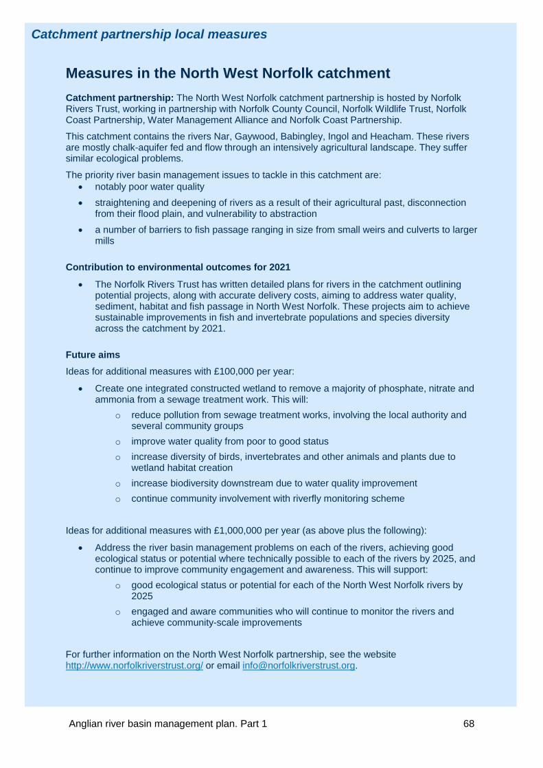
Catchment partnership local measures
Measures in the North West Norfolk catchment
Catchment partnership: The North West Norfolk catchment partnership is hosted by Norfolk Rivers Trust, working in partnership with Norfolk County Council, Norfolk Wildlife Trust, Norfolk Coast Partnership, Water Management Alliance and Norfolk Coast Partnership.
This catchment contains the rivers Nar, Gaywood, Babingley, Ingol and Heacham. These rivers are mostly chalk-aquifer fed and flow through an intensively agricultural landscape. They suffer similar ecological problems.
The priority river basin management issues to tackle in this catchment are: • notably poor water quality • straightening and deepening of rivers as a result of their agricultural past, disconnection
from their flood plain, and vulnerability to abstraction • a number of barriers to fish passage ranging in size from small weirs and culverts to larger
mills
Contribution to environmental outcomes for 2021
• The Norfolk Rivers Trust has written detailed plans for rivers in the catchment outlining potential projects, along with accurate delivery costs, aiming to address water quality, sediment, habitat and fish passage in North West Norfolk. These projects aim to achieve sustainable improvements in fish and invertebrate populations and species diversity across the catchment by 2021.
Future aims Ideas for additional measures with £100,000 per year:
• Create one integrated constructed wetland to remove a majority of phosphate, nitrate and ammonia from a sewage treatment work. This will:
o reduce pollution from sewage treatment works, involving the local authority and several community groups
o improve water quality from poor to good status o increase diversity of birds, invertebrates and other animals and plants due to
wetland habitat creation o increase biodiversity downstream due to water quality improvement o continue community involvement with riverfly monitoring scheme
Ideas for additional measures with £1,000,000 per year (as above plus the following):
• Address the river basin management problems on each of the rivers, achieving good ecological status or potential where technically possible to each of the rivers by 2025, and continue to improve community engagement and awareness. This will support:
o good ecological status or potential for each of the North West Norfolk rivers by 2025
o engaged and aware communities who will continue to monitor the rivers and achieve community-scale improvements
For further information on the North West Norfolk partnership, see the website http://www.norfolkriverstrust.org/ or email [email protected].
Anglian river basin management plan. Part 1 68

Catchment partnership local measures
Measures in the Old Bedford and Middle level catchment Catchment partnership: The Old Bedford and Middle Level Water Care partnership was formed in 2012 and is hosted by Cambridgeshire Action with Communities in Rural England (ACRE). Its membership comprises statutory, charitable and voluntary organisations operating across the catchment. The partnership members are listed on the website (see link below).
The priority river basin management issues in this catchment are:
• developing a national voice on the importance and uniqueness of the Fenland catchments and the different challenges that they face
• fully understanding what ‘Good Ecological Potential’ looks like in an artificial catchment • continuing to grow and strengthen the partnership, ensuring that the organisations in the
partnership can have a say on the improvement of the local water environment Contribution to environmental outcomes for 2021
• the partnership is still in an early phase and therefore work is focused on building and strengthening the partnership
• the partnership has secured funding for a community ownership project in Ramsey, which will be developed in other market towns in the catchment
• The partnership intends to: o develop a plan for achieving additional funds and investment, ensuring that the
catchment partnership is sustainable o develop national and local links to other catchment partnerships, to ensure that
the Catchment Based Approach national strategic inputs align with the unique nature of the Fenland catchments
o address (where appropriate and financially viable) failures associated with hydromorphology, reduce phosphate concentrations in the catchment and achieve a greater awareness of invasive non-native species (INNS); reducing numbers and preventing establishment of new INNS
Future aims Ideas for additional measures with £100,000 per year:
• engage communities to take ownership of their local water environment and provide access to the water environment
• demonstrate and promote the benefits of collaborative working
• raise awareness and prevent the spread of INNS
Ideas for additional measures with £1,000,000 per year (as above plus the following):
• contribute to landscape scale habitat creation and restoration within the Fens
• identify locations and implement tertiary phosphate treatments at sewage treatment works
Further information is available at: https://watercarepartnership.wordpress.com/
Anglian river basin management plan. Part 1 69

Catchment partnership local measures
Measures in the Upper and Bedford Ouse catchment Catchment partnership: The Upper and Bedford Ouse catchment partnership was formed in 2014 and is hosted by Bedfordshire Rural Communities Charity. The core group also includes the Environment Agency, Forest of Marston Vale Trust, Great Ouse Area of Outstanding Natural Beauty Working Group, Greensand Trust, Milton Keynes Parks Trust and Upper Ouse Fisheries Consultative Association. Other members, including statutory, charitable and voluntary organisations operating across and within the catchment are listed on the website (see link below). The partnership hopes to involve more organisations in its work, such as the Canal and River Trust, Cranfield University/River Restoration Centre and local authorities.
The priority river basin management issues to tackle in this catchment are the negative impacts on habitats and ecological diversity caused by:
• the physical modification of watercourses
• invasive non-native plant and animal species (INNS)
• pollution (diffuse and point source)
Contribution to environmental outcomes for 2021 The partnership is in the early stages of its development and, as a ‘growing’ partnership, will:
• continue to engage with local communities, find more partners and people to work with and identify project opportunities
• endeavour to secure funding to carry out project work and to support itself as a thriving and sustainable partnership
• deliver its 2015/16 Catchment Partnership Action Fund river restoration project
Future aims Ideas for additional measures with £100,000 per year:
• facilitate community and landowner engagement and awareness raising in every water body, including:
o recruitment and training of volunteers on a range of citizen science initiatives o developing and delivering a schools education programme o undertaking catchment walkover surveys (professional and training volunteers) in
areas where least information is known o creating a minimum of 1 flagship project per year to act as a national
pilot/exemplar Ideas for additional measures with £1,000,000 per year (as above plus the following):
• improve the status of water bodies in the Upper and Bedford Ouse Catchment and return them to a near natural state through flagship projects such as development of Bedford sewage treatment works tertiary treatment reed bed
• undertake INNS surveying, eradication and monitoring • reduce the negative impacts of physical modification through:
o retrofitting of sustainable drainage systems on urban and rural surface water discharges
o removal of manmade structures and/or fish pass installation Further information on the partnership is available at: http://ubocp.org.uk/
Anglian river basin management plan. Part 1 70

Catchment partnership local measures
Measures in the Welland catchment Catchment partnership(s): The Welland Valley Partnership is hosted and chaired by the Welland Rivers Trust. The organisations involved include the Environment Agency, Natural England, regional Wildlife Trusts, Harborough District Council, Rutland County Council, Game and Wildlife Conservation Trust, Welland and Deepings Internal Drainage Board, University of Leicester, the National Farmers’ Union, Anglian Water, South Lincolnshire Fens Partnership and the Angling Trust.
The priority river basin management issues to tackle in the catchment are water quality, habitat quality and hydromorphology.
Contribution to environmental outcomes for 2021
• The Water Friendly Farming project will continue to reduce on the ground diffuse pollution in the Eyebrook and Stonton catchments, which will improve water quality.
• The Werrington Brook Project will be carried out in Peterborough, using Grant in Aid as contributory only funding to a larger local authority budget. This project will improve morphology, dissolved oxygen, phosphate, invertebrates, macrophytes and fish, as well as the amenity value within this urban area.
• The Catchment Partnership Action Fund project for the Stamford water meadow, mill stream and main Welland will benefit invertebrates, macrophytes and fish populations and improve water quality within the project area.
• The partnership has a large list of potential project areas and measures that have been identified from the creation of a catchment plan. This was formulated to specifically identify the main issues and problem areas within the Welland catchment and what potential measures could be applied for improvement. The benefits will target river basin management improvements with additional benefits that could include some flood resilience, education or social improvements through community engagement.
Future aims Ideas for additional measures with £100,000 per year:
• In-river habitat improvement works to encourage the establishment of missing key habitat such as riffles, pools and marginal space. This will improve habitat quality, resolving failures in fish, invertebrate and macrophyte populations.
• Action to improve water quality though reduction of diffuse pollution. This will increase awareness and responsibility of water quality issues, and lead to improved phosphate levels.
Ideas for additional measures with £1,000,000 per year (as above plus the following):
• Development of Welland catchment wide river restoration projects in-line with the catchment plan to improve water quality, habitat quality, fish and invertebrate populations alongside delivering educational benefits and improved public access.
• Opening up of back-water channels, historic channels, cut-off channels, and lost wet woodland/meadow from past channel straightening works through landowner co-operation, or purchasing land.
For more information and a copy of the plan contact: [email protected].
Anglian river basin management plan. Part 1 71

Catchment partnership local measures
Measures in the Witham catchment Catchment partnership(s): The Witham Catchment Partnership is made up of the Lincolnshire Rivers Trust, Canal and River Trust, Environment Agency, Internal Drainage Boards, Boston District Angling Association, Sleaford Navigation Trust, Grantham Anglers Association Fly Fishing Section, National Farmers’ Union and Lincolnshire Wildlife Trust.
The priority river basin management issues to tackle in the catchment are:
• diffuse pollution and other factors leading to excessive weed growth particularly on the Lower Witham
• lack of good quality riparian and in channel habitat in many areas and disconnection from the floodplain
• over abstraction and variable water level management
Contribution to environmental outcomes for 2021 The partnership is still in development stage. A steering group has been formed, the key issues identified and a list of aspirational project ideas has been developed. Funding has been secured for some of these projects.
• One project, focusing on river restoration on the River Slea, will result in improvements to the fish and invertebrate populations by 2021. Funding for this (£31,000 for one year) has been secured from the Catchment Partnership Action Fund.
• The partnership has carried out three Urban Opportunities Studies within the catchment in Lincoln, Grantham and Sleaford. At this stage it is not clear what specific improvements will take place as a result of these studies. However each study provides a set of project proposals which will address biology and water quality failures.
Future aims Ideas for additional measures with £100,000 per year:
• working with partners to complete a catchment plan which includes actions to help protect designated areas in our catchment
• complete river restoration projects on a number of water bodies where the lack of riparian and in-channel habitat is affecting ecology
• engaging communities to take ownership of their local water environment and providing access to the water environment
• build on previous work to identify and reduce pollution on a number of water bodies in the catchment through targeted urban and rural campaigns
• raising awareness of Lincolnshire waterways and promoting the benefits of collaborative working
• influencing and encouraging sustainable development for the water environment to aid climate change adaptation and mitigation
Ideas for additional measures with £1 million per year (as above plus the following):
• Develop a large scale river restoration project for the Witham catchment, creating important habitat for aquatic and terrestrial species. This will resolve failures in fish, invertebrates; increase recreational opportunities and engage local communities.
• Identifying and reducing pollution on all water bodies within the catchment, working with communities and companies to raise awareness.
Further information on the partnership is available at: http://lincsrivers.co.uk/
Anglian river basin management plan. Part 1 72

3.5. Forward look at measures beyond 2021 This section provides a summary of the measures which are envisaged as necessary for protected areas and water bodies to achieve their objectives for 2027 and beyond. It also describes opportunities which could enable additional measures to be implemented by 2021.
Measures to 2027 Table 22 contains a summary of the types of measures which are envisaged to be necessary to address each significant water management issue up to 2027. This is not exhaustive and will inevitably change. Change can occur for a variety of reasons including, new evidence, changes in water body status, funding availability, government policy changes, development impacts and climate change.
The measures in table 22 are required in addition to the measures to address the significant water management issues described in section 3.2. The summary programmes of measures and environmental objectives in this plan will be reviewed and updated in 2021. The WFD does not generally allow the timescale for the achievement of environmental objectives to be extended beyond 2027. Therefore as part of the plan update in 2021, choices will have to be made about the appropriate use of less stringent objectives.
Table 22: Summary of types of measures envisaged as necessary to achieve objectives for each significant water management issue
Types of measures envisaged in the river basin district
Main sectors involved in implementing the measures
Measures to address physical modification
• Improvement to condition of riparian zone and/or wetland habitats
• Improvement to condition of channel/bed and/or banks/shoreline
• Removal or easement of barriers to fish migration
• Vegetation management • Removal or modification of engineering
structure • Change to operations and maintenance
• Government (central and local government)
• Water industry • Industry services and
infrastructure (non governmental organisations, industry, manufacturing and other business, navigation, recreation, urban and transport) Rural land management
Measures to address pollution from waste water
• Mitigate/Remediate point source impacts on receptor
• Reduce point source pollution at source • Reduce point source pathways (i.e.
control entry to water environment) • Reduce diffuse pollution at source
• Government (central and local government)
• Water industry • Industry services and
infrastructure (industry, manufacturing and other business, waste treatment, transfer, storage and disposal, recreation, urban and transport)
• Rural land management
Anglian river basin management plan. Part 1 73

Types of measures envisaged in the river basin district
Main sectors involved in implementing the measures
Measures to manage pollution from towns, cities and transport
• Reduce diffuse pollution pathways (i.e. control entry to water environment)
• Mitigate/Remediate diffuse pollution impacts on receptor
• Reduce diffuse pollution at source
• Government (central and local government)
• Water industry • Industry services and
infrastructure (industry, manufacturing and other business, recreation, urban and transport)
• Rural land management
Measures to address changes to natural flow and level of water
• Control pattern/timing of abstraction • Water Demand Management
• Government • Rural land management • Industry services and
infrastructure (internal drainage boards; navigation; urban and transport) Water industry
Measures to address pollution from rural areas
• Reduce diffuse pollution at source • Mitigate/Remediate diffuse pollution
impacts on receptor
• Government (central government)
• Rural land management • Industry services and
infrastructure (non governmental organisations) Water industry
Measures to manage invasive non-native species
• Mitigation, control and eradication (to reduce extent)
• Building awareness and understanding (to slow the spread)
• Early detection, monitoring and rapid response (to reduce the risk of establishment)
• Government (central government)
• Rural land management
Anglian river basin management plan. Part 1 74

Section 3.6 contains further information on measures to achieve protected area objectives, including those with extended deadlines. The cost of programmes of measures provides a good indication of the scale and phasing of action. Table 23 shows the current assessment of the potential costs of measures to achieve the water body and protected area objectives in this plan. The costs of measures are broadly allocated to the sectors whose activities cause the problem in line with the ‘polluter pays principle’. Beyond the known funding to 2021, no decision has been made on where the costs will fall. In some cases, the sectors may not pay their own costs. Note figures are rounded to the nearest £10 million. Table 23 Summary of estimated costs and phasing of action
Sectors Total cost of measures over 37 years (undiscounted) to achieve objectives (£m)
Phasing to 2021 (% of total cost envisaged to 2021)
Phasing post 2021 (% of total cost envisaged after 2021)
Government 320 <10% >90%
Rural land management* 2580 <10% >90%
Industry, services and infrastructure 140 <10% >90%
Water industry 2010 20-30% 70-80%
*The rural land management costs are based on a range due to different scenarios of cost allocation. The midpoint is presented here to be
consistent with other costs.
Anglian river basin management plan. Part 1 75

Opportunities for additional measures There will be greater certainty on the measures that will be required between 2021 and 2027 when this plan is updated in 2021. Before then, a number of strategic reviews and funding streams could enable additional measures to be confirmed and/or implemented before 2021. Some of these opportunities are described below.
External funding sources The following funding sources could be used to implement measures.
• The LIFE Regulation, which was published on 20 December 2013, sets a budget for 2014 to 2020 of €3.4 billion for projects to invest in the environment and climate change. Calls for applications are annual, for priorities including nature, biodiversity, water, floods and drought.
• The Heritage Lottery Fund invests £375 million each year, a portion of this being available to environmental improvement projects through the 'Parks for People' (£100,000- £5 million) and 'Landscape Partnerships' (£100,000 - £3 million) programmes. Calls for applications can be once or twice a year and are often a 2 stage process.
• The government has asked Local Enterprise Partnerships to prepare economic strategies to inform the allocation of domestic and European ‘growth funds’, for example, the Single Local Growth Fund and the European Structural and Investment Funds. The criteria for allocation of these funds include environmental protection and sustainable development, providing an opportunity for water infrastructure that supports efficient and sustainable use of water.
Review of Urban Waste Water Treatment Directive designations The Urban Waste Treatment Directive aims to protect the water environment from the adverse effects of discharges of urban waste water and certain industrial discharges by specifying minimum treatment requirements as well as more stringent tertiary treatment when needed to protect designated sensitive receiving waters.
Sensitive area designations are currently reviewed every 4 years, the latest review will be completed in December 2015. The Environment Agency would like to see a move towards 6 yearly cycles to align with WFD but this would require changes to legislation.
EU Priority Substances Directive The 2013 revisions to the Priority Substances Directive have been transposed into domestic legislation. To comply with the new requirements, by 22 December 2018, the Environment Agency will submit a supplementary monitoring programmes and a preliminary programme of measures to the European Commission, with the aim of achieving good chemical status by 2027. The required measures will need to be considered in water company investment plans, as part of the 2019 Price Review and will be finalised in the 2021 update of the river basin management plans. All of the required measures will be made operational by 2024.
Preliminary investigations of chemicals with new European standards indicate that they could have a significant impact on good status in future. Sewage may be a significant source of some of these chemicals. Whilst sewage treatment is generally effective at reducing inputs this may not always be sufficient. Some substances have restrictions or bans on usage but these may take many years to result in lower environmental concentrations.
Anglian river basin management plan. Part 1 76

Review of water company price limits Ofwat is expected to review the prices that water companies can charge their customers in 2019. As part of this process, water companies will need to update their business plans to include (amongst other things) additional environmental improvements agreed with their customers and the Environment Agency.
Common Agricultural Policy The current agreement for funding from the Common Agricultural Policy, including the basic payment scheme and rural development programme that encompasses Countryside Stewardship, ends in December 2020. Negotiations for continued funding for the period 2021 to 2027 have not yet begun.
Water resources management plans Water companies will publish new plans in 2019. These plans set out how they will balance supply and demand for water over a 25 year period. The new plans will enable them to take account of expected changes in demand for water and in their available supply as a result of climate change and population growth as well as any new measures needed to deliver environmental objectives.
Review of nitrate vulnerable zones designations and action plans Every 4 years, the UK is required to review the evidence in relation to the extent of nitrate vulnerable zones (NVZ) and the effectiveness of the action programme introduced by the Regulations and to implement changes where required. NVZs are a means of reducing or preventing water pollution caused by nitrates from agricultural sources. The next review is underway and any changes are expected to be implemented in January 2017.
Further information in this document • You can find more information on the ongoing measures to prevent deterioration for each
significant water management issue in section 3.2. Information elsewhere in the river basin management plan
• You can find more information about the catchment economic appraisal in section 5.5 of Part 2: RBMP overview (www.gov.uk/government/collections/river-basin-management-plans-2015).
Supporting information • You can find a list of the measures needed to achieve water body objectives for 2027 and
beyond on the Environment Agency’s ShareFile service (https://ea.sharefile.com/d-sabbd14301a44d5e9).
• You can find the impact assessment on the river basin management plan web pages (www.gov.uk/government/collections/river-basin-management-plans-2015).
Sharefile links have been updated – please use the guide to accessing data and information to access files https://www.gov.uk/government/publications/river-basin-management-plans-accessing-data-and-information-guide
Anglian river basin management plan. Part 1 77

3.6. Additional measures to achieve protected area objectives Measures have been developed for protected areas that are at risk of or do not currently meet their objectives. Table 24 summarises the action planning process.
Table 24: Summary of measures for protected areas
Protected Area Programme Drinking water protected areas - surface water and groundwater
Safeguard zones have been established for water sources in drinking water protected areas where extra treatment is likely to be required in the future. Safeguard zone action plans have been developed including measures needed to manage activities that may threaten raw water quality for surface waters and ground waters.
Economically significant species (shellfish waters)
Shellfish water action plans have been produced for all designated shellfish waters, which include measures aiming to observe the microbial shellfish flesh standards.
Recreational waters (bathing waters)
Bathing water profiles have been produced for all designated sites. They include details of the measures needed to achieve compliance with the revised standards that came into force in 2015.
Further information is available on the measures for those bathing waters at risk of not achieving sufficient in 2015 in the bathing water action plans (continuing at risk).
Nutrient sensitive areas (Urban Waste Water Treatment Directive)
Measures have been identified to make sure that all relevant discharges from waste water treatment plants within the sensitive area have appropriate phosphorus or nitrogen emission standards.
Nutrient sensitive areas (nitrate vulnerable zones)
The objective of the Nitrates Directive is to reduce water pollution caused by nitrates from agricultural sources and to prevent further such pollution occurring. Nitrate Vulnerable Zones (NVZs) are designated where nitrate concentrations in surface and/or groundwaters are high or increasing, or where waters are, or may become eutrophic, due to agricultural nitrate pollution. Farmers within NVZs must comply with mandatory action programme measures to reduce agricultural nitrate losses. In addition a code of good agricultural practice has been established, for voluntary implementation by all farmers.
Natura 2000: Water dependent Special Areas of Conservation (SACs) and Special Protection Areas for Wild Birds (SPAs)
Natural England has developed site improvement plans (SIPs) for water dependent sites.
SIPs provide an overview of issues affecting the site condition; identify priority actions, timescales for implementation and potential funding sources. Natural England monitors, reviews and updates SIPs where appropriate.
Anglian river basin management plan. Part 1 78

Supporting information: • You can find more information on the measures in protected areas at the following locations:
o For drinking water protected areas for surface water (https://ea.sharefile.com/d-scac3ff7da4a424eb) and for groundwater (https://ea.sharefile.com/d-sa22fd79de304532a)
o For economically significant species (https://ea.sharefile.com/d-s84c5554e50947dbb)
o You can access more information on recreational waters on the Bathing Water Explorer (http://environment.data.gov.uk/bwq/profiles/) and in the bathing water action plans (continuing at risk) on the Environment Agency’s ShareFile service https://ea.sharefile.com/d-s2c9919e38f04798b
o For Nitrate vulnerable zones visit the NVZ web pages (www.gov.uk/nitrate-vulnerable-zones)
o The Natura 2000 site improvement plans are available on Natural England’s web site (http://publications.naturalengland.org.uk/category/4878851540779008)
Sharefile links have been updated – please use the guide to accessing data and information to access files https://www.gov.uk/government/publications/river-basin-management-plans-accessing-data-and-information-guide
Anglian river basin management plan. Part 1 79
This section contains an assessment of what has been achieved and what has happened since the first river basin management plan was published in 2009. It includes a summary of the improvements made to the evidence used in river basin management planning, a report on the implementation of measures, and a summary of progress towards achieving the environmental objectives in the 2009 plan and where progress has not been made.
4. Changes from 2009 to 2015
Anglian river basin management plan. Part 1 80

4.1. Improvements in evidence Over the last 6 years the Environment Agency has done much to improve the understanding of the water environment. The quantity and quality of the evidence available has grown because of significant investment.
• In England, an additional £4.7 million pounds has been invested in a new ecological monitoring programme for rivers and an additional £1.5 million pounds invested in chemical monitoring technology. This means that the number of element classification results in the river basin district has increased from 5,948 in 2009 to 6,698 in 2015.
• In the river basin district, more than 2,800 investigations have been carried out to identify the reasons (pressures, and the sources of the pressures) why good status and protected area objectives have not been achieved.
• The actions that would be needed to achieve good status and protected area objectives have been identified.
• Through detailed economic appraisal, there is an improved understanding of the benefits the water environment can provide and the cost of the measures needed to realise the benefits.
• The latest generation of environmental assessment criteria has been introduced in collaboration with a range of partners and leading scientists. These improvements to methods mean that the classification results are now a better interpretation of the general health of the water environment. These changes include:
o new standards for additional chemical substances
o updated standards for existing physico-chemical elements
o new and improved biological assessment tools and new intercalibrated biological classification boundary values.
• Improvements have been made in mapping of the water body network.
• Improved risk assessments have been introduced to help target future monitoring programmes, and predict and help prevent potential deterioration in the water environment.
This new evidence was used in the review and update of the environmental objectives in the 2009 plan.
Anglian river basin management plan. Part 1 81

Further information in this document • You can find summaries of the latest water body classification results and the reasons for not
achieving good status in section 5.
• You can find more information on risk assessments in section 1.4.
Information elsewhere in the river basin management plan • You can find more information in Part 2: RBMP overview available on the river basin
management plan web pages (www.gov.uk/government/collections/river-basin-management-plans-2015) for:
o the process used to review and update the environmental objectives in the 2009 plan, in section 5.2
o measures identification in section 5.2
o economic appraisals in section 5.3
o review of the water body network in section 4.1
o review and update of heavily modified water body designations in section 4.1
o revised risk assessments in section 4.4
• GeoPDF maps showing the latest classification results can be found on the Environment Agency’s ShareFile Service (https://ea.sharefile.com/d-sed90a482d5843d88).
• You can find a spreadsheet containing the reasons for not achieving good status on the Environment Agency’s ShareFile service (https://ea.sharefile.com/d-s0faa355450243538)
Supporting information • You can find the full description of changes to environmental standards on the UKTAG website
(http://www.wfduk.org/).
• The full description of changes to biological methods can be found on the UKTAG website (http://www.wfduk.org/).
Sharefile links have been updated – please use the guide to accessing data and information to access files https://www.gov.uk/government/publications/river-basin-management-plans-accessing-data-and-information-guide
Anglian river basin management plan. Part 1 82

4.2. Measures implemented Planned measures implemented since 2009 Most of the measures (over 99%) summarised in the 2009 plans have been completed. A few measures have not been completed in the river basin district for the following reasons:
• 2 measures have been reassessed and are no longer needed or considered effective
• 1 was not funded (funding withdrawn)
Additional measures implemented since 2009 As well as the measures in the 2009 plans, a significant number of other measures have been implemented. For instance in England, the government provided £90 million between 2010 and 2015 for additional measures to improve the physical water environment, reduce pollution, and reduce the impact of invasive non-native species.
It is estimated that the additional measures in the river basin district represent a further investment of at least £12.1 million. Table 25 gives a summary of the issues addressed and an indication of the scale of additional measures.
Table 25 – Summary of additional measures in the river basin district
Significant water management issue
Number of measures
Cost (£Million)
Number of water bodies benefitting
Physical modifications 101 8.6 243
Pollution from rural areas 18 1.8 79
Pollution from town, cities and transport 12 1.0 28
Pollution from abandoned mines 0 0 0
Invasive non-native species 14 0.2 35
Other 6 0.5 27
Total 151 12.1 412
Supporting information • You can download a spreadsheet of the additional local measures implemented from 2009 from
the Environment Agency’s ShareFile service (https://ea.sharefile.com/d-s13e5e39caef432d9).
Sharefile links have been updated – please use the guide to accessing data and information to access files https://www.gov.uk/government/publications/river-basin-management-plans-accessing-data-and-information-guide
Anglian river basin management plan. Part 1 83

Effectiveness of measures implemented since 2009 Most of the measures implemented between 2009 and 2015 have resulted in improvements to the quality of the water environment, providing significant additional benefits. However, the scale of the improvements has not always been enough to fully secure compliance with WFD environmental objectives (protected area and water body status objectives) set in the 2009 plan. Section 4.3 identifies some of the reasons for this.
Table 26 contains a summary of how effective the measures implemented since 2009 were at achieving WFD environmental objectives. Measures are grouped by each significant water management issue. The assessment is based on the measures implemented across England and not just in this river basin district.
Table 26: Summary assessment of the effectiveness of measures for each significant water management issue (England level assessment)
Physical modifications
Obstructions Removing or lowering weirs and building fish passes has generally been effective. In some cases, it has not been possible to fully remove the pressure because of the obstruction’s historic value or the need to prevent erosion or mobilisation of contaminated sediments. In some cases full compliance with WFD environmental objectives has not yet been achieved because other barriers elsewhere in the catchment are still present.
Habitat improvement Habitat improvements, from large-scale river restoration to relatively minor schemes on small watercourses, have generally been effective. They have led to improvements in fish populations and other wildlife. The effectiveness of these schemes at achieving compliance with WFD environmental objectives will only become apparent once the new habitat and associated wildlife has matured. In some cases, it is expected that additional restoration elsewhere in the catchment will be required to support a fully functioning ecosystem.
Pollution from waste water
There were over 300 improvement schemes implemented at sewage treatment works since 2009. These have been effective at helping to achieve compliance with WFD environmental objectives.
Pollution from rural areas
Government advice Catchment Sensitive Farming was effective at encouraging farmers to take up measures to help achieve WFD environmental objectives (mainly for protected areas). In areas where Catchment Sensitive Farming was targeted, between 2006 and 2013, the estimated quantity of pollutant (including phosphorus, nitrate, sediment and faecal indicator organisms) released from agricultural sources reduced by between 4% and 12% (on average).
Regulation Regulation has reduced the impact of pollution incidents and helped to prevent deterioration. There is some evidence that action plans for nitrate vulnerable zones helped to reduce pollution from nutrients. The overall effectiveness can only be assessed over a longer period.
Anglian river basin management plan. Part 1 84

Industry initiatives A number of schemes have promoted voluntary action including, advice and grants through local catchment groups, advice through the Campaign for the Farmed Environment, and work lead by water companies to improve the quality of water they abstract for public water supply. Advice is effective at promoting good farming practice. Measures that go beyond good practice greatly increase where grants have been provided. Many of these schemes resulted in improvements to the local water environment.
Environmental stewardship (2006 to 2014) There was good uptake of measures to protect the water environment. Measures were not always placed where most benefit could be gained or the uptake sufficiently concentrated within a catchment to reduce pressures enough to achieve compliance with WFD environmental objectives.
Cross compliance Compliance with environmental conditions attached to the Single Farm Payment was high. The environmental conditions were strengthened in 2010 and 2015. The associated measures had a small impact on the quality of the water environment
Changes to the natural flow and level of water
Changes in abstraction licences The national Restoring Sustainable Abstraction programme has been effective at improving habitat for fish and other wildlife. Voluntary and compulsory action has resulted in changes to over 200 abstraction licences (by the Environment Agency and government). As a result of this, 27 billion litres of water has been returned to the environment.
Nationally this programme has been effective at helping to achieve compliance with WFD environmental objectives, in particular those for Natura 2000 protected areas
Demand management Demand management and water efficiency techniques have been implemented by many sectors including government, water industry, independent bodies and trade associations.
Local Development Plans / Frameworks have been introduced which set out local plan policies requiring new homes to meet the tighter water efficiency standard of 110 litres per person per day as described in Part G of Schedule 1 to the Building Regulations 2010.
Water companies have reduced leakage from their supply networks and increased the number of homes with meters across water stressed areas.
Most of these have been effective at a local scale.
Pollution from towns, cities and transport
A variety of measures have been implemented to reduce pollution from urban areas. These include: contaminated land restoration; installation of sustainable drainage systems for new and existing developments; treatments to remediate road run-off; regulatory action following pollution incidents; initiatives to resolve misconnected foul drainage systems; and pollution prevention advice to occupiers of industrial estates.
Most of these measures have been effective at the local scale. However, in some cases the effectiveness is low, as there needs to be more measures within an area if improvements are to be sustained over the long term. Given the scale, cost and complexity of this issue, the measures have not been effective at reducing the pressure enough to achieve compliance with WFD environmental objectives.
Anglian river basin management plan. Part 1 85
Invasive non-native species
A variety of measures have been implemented to prevent the introduction and spread of invasive non-native species. These have been moderately effective and have slowed the deterioration in the biodiversity of affected waters and the spread to unaffected waters. Measures to remove invasive non-native species from affected waters are only effective for a minority of species where a rapid response to their presence is possible. Evidence gathered in cycle 1 has confirmed that it is technically infeasible to remove most species once they are established. At locations such as Natura 2000 sites, intensive (and ongoing) action can mitigate the pressure, but not remove it.
Anglian river basin management plan. Part 1 86

4.3. Progress towards achieving the environmental objectives in the 2009 plan Preventing deterioration To assess compliance with the WFD objective of preventing deterioration, 2015 classifications results (based on data up to the end of 2014) using the standards and classification tools used in 2009, were compared with the 2009 classification baseline. The assessment considered whether the water body had deteriorated from one status class in 2009 to a lower one in 2015. This was applied to a water body's overall status and to the status of each element used in classification.
The results of this assessment for water bodies in the river basin district are summarised in Table 27. Table 34 in section 5 provides a breakdown by elements.
Table 27: Water bodies that have deteriorated (at >75% confidence)
Water bodies Number Percentage Surface water ecological status 14 2% Surface water chemical status 0 0% Groundwater quantitative status 0 0% Groundwater chemical status 0 0%
Where deterioration of status has occurred, the cause needs to be identified and measures to restore the water body to its previous status put in place as soon as possible.
In some cases, reported deterioration may be a result of changes to monitoring programmes or be an artefact of monitoring and assessment processes (sampling error). Distinguishing these changes from real deterioration in the quality of the environment that has been caused by a new activity or a change in an existing pressure in a catchment can be difficult.
Table 34 in section 5 contains a summary of the causes of deterioration that have already been identified. This summary is for each element by pressure and sector. You can also download a spreadsheet containing the water body elements that have deteriorated in status since 2009 (see further information box at the end of this section).
In certain and specific circumstances deterioration of status is permitted. These circumstances are described in Article 4.6 (temporary deterioration) and Article 4.7 (new modifications) of the WFD. No cases that meet these requirements have been identified in this river basin district.
Protected area objectives Drinking water protected areas
The Drinking Water Inspectorate is the competent authority for the drinking water directive. They publish an annual report detailing compliance with the directive’s water quality requirements.
The Environment Agency has established safeguard zones and produced associated action plans for all relevant drinking water protected areas to manage the risk of water quality deteriorating.
Anglian river basin management plan. Part 1 87

Following improvements in the knowledge of the pressures in catchments, improved monitoring programmes for chemicals and new abstractions which have come about, the number of drinking water protected areas classified as at risk of water quality deterioration or at poor chemical status (for groundwater only) has increased. Measures such as providing advice and guidance to stakeholders, capital grants for infrastructure improvements (for example biobeds) and payment for ecosystem services have been used to protect water quality in drinking water protected areas.
Economically significant species (freshwater fish)
The freshwater fish directive was repealed in December 2013. Environmental objectives for freshwater fish protected areas ceased to have effect from that date. An equivalent level of protection is provided by the water body objectives in this plan.
Economically significant species (shellfish waters)
The shellfish water directive was repealed in December 2013. Shellfish waters protected areas have been maintained and an equivalent level of protection is being provided by domestic legislation. Monitoring used to assess compliance with the shellfish flesh standards has significantly increased. Although there has been no significant change in the quality of the water environment in the protected areas, the improved monitoring has lead to a reduction in reported compliance.
The current status of shellfish projected areas is summarised in section 2.4.
Recreational waters (bathing waters)
A revised bathing water directive introduced new water quality objectives for bathing water protected areas from 2015. Projected classification of bathing waters against the new standards is summarised in section 2.4. Compliance with the water quality standards of the old bathing water directive was assessed for the final time in 2014. These results are summarised in Table 28. This shows an increase in compliance since 2009.
Table 28: Bathing water compliance with old (1976) Bathing Water Directive objectives:
Year Number of bathing waters
% compliant with mandatory standards
% compliant with guideline standards
2009 37 100 84
2014 38 100 92
Natura 2000 sites: Water dependent Special Areas of Conservation or Special Protection Areas
In 2009 43 Natura 2000 protected areas in the river basin district had an objective of maintaining or achieving their water dependent conservation objectives by 2015 (assessed on basis of measures being underway/complete, known pressures, anticipated measures and likely improvements in condition). Of these, 10 had all measures completed (i.e. no further intervention is required) to enable their water dependent objectives to be achieved by 2015, based on knowledge of current pressures on the sites.
Water body status objectives As a result of the improvements in monitoring, standards and classification tools described in section 4.1, it is not possible to identify environmental change by simply comparing the 2009
Anglian river basin management plan. Part 1 88

and 2015 classification baselines. Instead, a set of 2015 classifications results (based on data up to the end of 2014) has been produced using the standards and classification tools used in 2009. This helps identify where they may have been an actual environmental change since 2009.
Table 29 shows the percentage of water bodies at good status for the:
• 2009 baseline
• predicted outcomes in 2015 envisaged in the 2009 plans
• 2015 classification results produced using the 2009 methods
Table 29: Comparison of 2009 baseline with 2015 predicted and actual results (using the water body network, standards and classification tools used in 2009)
Percentage of water bodies at good or better status
2009 2015 predicted
2015 actual
Surface water ecological status 18 19 13 Surface water chemical status 10 11 13 Groundwater quantitative status 65 65 58 Groundwater chemical status 65 65 52 Overall status 19 20 14 Although many of the measures completed over the last 6 years are providing benefits for the local environment, the comparison shows a reduction in the number of water bodies at good status. After 2009 the Environment Agency put additional biological monitoring in place and improved the design of the monitoring network. The new monitoring has revealed more symptoms of environmental issues. The change between 2009 and 2015 reported in the table above does not necessarily constitute a real environmental deterioration. Over this period 712 individual water body elements improved by one or more class.
There may be several reasons why the predicted improvement in status has not yet been seen. These include:
• the measures have not been as effective at reducing pressures at the water body scale as expected
• the environmental standards which the measures were designed to achieve were not tight enough to fully protect the biological elements
• there are pressures acting on the water bodies that were not known in 2009
• improvements in the monitoring network identifying that pressures are having more impact than previously detected
• some classification elements have improved in status, but no improvement in the status of the water body has been reported due to the use of the ‘one out all out’ classification rule
Anglian river basin management plan. Part 1 89

Further information in this document
• You can find a summary of the causes of deterioration that have already been identified in section 5.
Information elsewhere in the river basin management plan • A more detailed explanation of the approach to preventing deterioration can be found in can be
found in section 2.2 of Part 2: RBMP overview (www.gov.uk/government/collections/river-basin-management-plans-2015).
• You can find detail on the circumstances in which deterioration may be permitted (temporary deterioration and new modifications) in section 3.1.4 of Part 2: RBMP overview (www.gov.uk/government/collections/river-basin-management-plans-2015).
• You can download spreadsheets containing: o a spreadsheet containing the 2009 classification baseline, predicted and actual
results for 2015 using the standards and classification tools used in 2009 o a map of the 2015 classification results using the standards and classification tools
used in 2009 o a spreadsheet containing the water body elements that have deteriorated in status
since 2009 from the Environment Agency’s ShareFile service (https://ea.sharefile.com/d-s13e5e39caef432d9).
Sharefile links have been updated – please use the guide to accessing data and information to access files https://www.gov.uk/government/publications/river-basin-management-plans-accessing-data-and-information-guide
Anglian river basin management plan. Part 1 90

This section provides a summary of the key statistics for the river basin district at water body and quality element level.
5. Summary statistics
Anglian river basin management plan. Part 1 91

Summary statistics tables The tables in this section provide a summary of the plan data for the river basin district and can be used for quick reference. To understand the purpose of the data and how it has been generated see the relevant sections earlier in this document. The detailed data behind the summaries can also be accessed by following the links in the relevant sections.
The following descriptions explain the content of the tables and the further information box shows where more information can be accessed.
• Table 30: Summary statistics for the Anglian river basin district: Water bodies: shows the status, by percentage, of the different types of water bodies in the river basin district. It also shows the predicted outcome by 2021 and the objective.
• Table 31: Summary statistics for the Anglian river basin district: Elements: shows the status, by percentage, of the water body elements in the river basin district. It also shows the predicted outcome by 2021 and the objective.
• Table 32: Pressures preventing waters reaching good status and the sectors
identified as contributing to the impact (reasons for not achieving good status): shows the number of reasons for water bodies not achieving good status for each pressure and which sector is contributing to this. The table shows individual counts and there may be more than one reason in a single water body.
• Table 33: Significant water management issues (SWMIs) preventing waters
reaching good status and the sectors identified as contributing to the impact (reasons for not achieving good status): shows the number of reasons for water bodies not achieving good status because of each significant water management issue and which sector is contributing to this. The table shows individual counts and there may be more than one reason in a single water body
• Table 34: Reasons for deterioration by one or more status class between 2009 and 2015 and the sectors identified as contributing to the impact: shows the number of reasons for water body elements deteriorating by one of more status class, with 75% confidence, for that pressure and which sector is contributing to the deterioration. The table shows individual counts, if there is more than one element deteriorating in a water body, then there will be more than one reason assigned.
Further information in this document: • You can access the detail behind Table 30 and Table 31 on the current status, predicted
outcomes and objectives for water bodies and elements in section 2.
• The detail behind Table 33 on the significant water management issues can be found in section 1.4.
• You can find more information on Table 34 and the reasons for deterioration in section 4.3.
Anglian river basin management plan. Part 1 92

Table 30: Summary statistics for the Anglian river basin district: Water bodies
*SWTs are surface water transfers
Rivers,
Canals and SWTs*
Lakes Estuaries Coastal Surface Waters Combined
Ground water
All Water Categories
% of water bodies at good or better ecological status/potential now 10% 15% 11% 15% 11% % of water bodies predicted to be at good ecological status/potential or better by 2021
13% 17% 11% 15% 13%
% of water bodies with an objective of good ecological status/potential or better
42% 57% 22% 31% 43%
% of water bodies at good chemical status now 99% 98% 100% 100% 99%
% of water bodies predicted to be at good chemical status by 2021 99% 98% 100% 100% 99%
% of water bodies with an objective of good chemical status >99% 100% 100% 100% >99% % of water bodies at good chemical (groundwater) status now 52%
% of water bodies predicted to be at good chemical (groundwater) status by 2021
52%
% of water bodies with an objective of good chemical (groundwater) status
58%
% of water bodies at good quantitative status now 48% % of water bodies predicted to be at good quantitative status by 2021 58%
% of water bodies with an objective of good quantitative status 84% % of water bodies at good or better overall status now 10% 15% 11% 15% 11% 29% 12%
% of water bodies predicted to be at good or better overall status by 2021
13% 17% 11% 15% 13% 32% 14%
% of water bodies with an objective of good or better overall status 42% 57% 22% 31% 43% 55% 43%
Anglian river basin management plan. Part 1 93

Table 31: Summary statistics for the Anglian river basin district: Elements
*Surface water transfers
Rivers, canals and SWTs*
Lakes Estuaries Coastal Surface waters combined
Ground- water
All water categories
% of ecological elements at good or better status now (biological, physico-chemical and specific pollutants) 77% 61% 75% 78% 76% % of ecological elements predicted to be at good status or better by 2021 (biological, physico-chemical and specific pollutants) 78% 64% 75% 79% 78% % of ecological elements with an objective of good status or better (biological, physico-chemical and specific pollutants) 87% 84% 87% 81% 86% % of chemical elements at good status now 99% 98% 100% 100% 99% % of chemical elements predicted to be at good status by 2021 99% 98% 100% 100% 99% % of chemical elements with an objective of good status >99% 100% 100% 100% >99% % of chemical (groundwater) elements at good status now 88% % of chemical (groundwater) elements predicted to be at good status by 2021 88% % of chemical (groundwater) elements with an objective of good status 90% % of quantitative elements at good status now 77% % of quantitative elements predicted to be at good status by 2021 80% % of quantitative elements with an objective of good status 96% % of elements at good or better status now
80% 68% 85% 86% 80% 84% 80% % of elements predicted to be at good or better status by 2021
82% 71% 85% 87% 81% 85% 82% % of elements with an objective of good or better status 89% 87% 92% 88% 89% 93% 89%
Anglian river basin management plan. Part 1 94

Table 32: Pressures preventing waters reaching good status and the sectors identified as contributing to the impact (reasons for not achieving good status) in the Anglian river basin district
Pressure
Agriculture and rural
land management
Industry Mining and quarrying Navigation Urban and
transport Water
Industry Local & central
government
Domestic general public
Recreation Waste
treatment and
disposal Other No sector
responsible Sector under investigation Total
Abstraction and flow 40 7 0 0 0 43 6 0 0 0 6 11 9 122
Chemicals 23 4 0 0 1 1 0 2 0 1 5 1 12 50
Biochemical oxygen demand
1 1 0 0 1 7 0 0 0 0 0 0 0 10
Dissolved oxygen 47 7 0 0 11 45 8 1 0 0 7 38 8 172
Ammonia 4 12 0 0 4 16 0 1 1 0 0 0 4 42
Fine sediment 77 0 0 0 7 1 2 0 0 0 8 2 0 97
Invasive non native species
0 0 0 0 0 0 0 0 0 0 0 42 0 42
Nitrate 5 0 0 0 0 0 0 0 0 0 1 0 12 18
Phosphate 511 28 0 0 50 381 4 13 1 0 26 7 4 1025
Physical modification 247 9 0 17 48 15 178 1 36 0 54 4 48 657
Anglian river basin management plan. Part 1 95

Table 33: Significant water management issues preventing waters reaching good status and the sectors identified as contributing to the impact (reasons for not achieving good status) in the Anglian river basin district
Significant water management
issue
Agriculture and rural
land management
Industry Mining and quarrying Navigation Urban and
transport Water
Industry Local & central
government
Domestic general public
Recreation Waste
treatment and
disposal Other No sector
responsible Sector under investigation Total
Physical modifications 249 9 0 17 52 16 184 1 36 0 59 1 47 671
Pollution from waste water 1 34 0 0 22 454 4 17 2 1 21 0 0 556
Pollution from towns, cities and transport
0 18 0 0 48 0 0 0 0 0 23 0 2 91
Changes to the natural flow and level of water
50 7 0 0 2 43 9 0 0 0 10 0 0 121
Invasive non-native species
0 0 0 0 0 0 0 0 0 0 0 46 0 46
Pollution from rural areas 665 0 0 0 0 0 0 0 0 0 1 0 0 666
Pollution from abandoned mines
0 0 0 0 0 0 0 0 0 0 0 0 0 0
Anglian river basin management plan. Part 1 96

Table 34: Reasons for deterioration from one or more status class between 2009 and 2015 and the sectors identified as contributing to the impact in the Anglian river basin district
Pressure causing
deterioration
Agriculture and rural
land management
Industry Mining and quarrying Navigation Urban and
transport Water
Industry Local & central
government
Domestic general public
Recreation Waste
treatment and
disposal Other No sector
responsible Sector under investigation Total
Abstraction & Flow 4 0 0 0 0 1 0 0 0 0 0 1 0 6
Chemicals 0 0 0 0 0 0 0 0 0 0 0 1 0 1
Biochemical oxygen demand
0 0 0 0 0 0 0 0 0 0 0 0 0 0
Dissolved Oxygen 0 0 0 0 0 1 0 0 0 0 0 4 2 7
Ammonia 0 1 0 0 0 2 0 0 0 0 0 0 2 5
Fine sediment 6 0 0 0 0 0 0 0 0 0 1 0 0 7
Invasive non native species 0 0 0 0 0 0 0 0 0 0 0 8 0 8
Nitrate 0 0 0 0 0 0 0 0 0 0 0 0 0 0
Phosphate 4 1 0 0 0 4 0 3 0 0 0 0 4 16
Physical Modification 5 0 0 0 0 1 2 0 0 0 0 1 0 9
Anglian river basin management plan. Part 1 97

www.gov.uk/environment-agency
LIT 10311