water conservation in sardinia
TRANSCRIPT

American Geographical Society
Water Conservation in SardiniaAuthor(s): Marcello VinelliSource: Geographical Review, Vol. 16, No. 3 (Jul., 1926), pp. 395-402Published by: American Geographical SocietyStable URL: http://www.jstor.org/stable/208709 .
Accessed: 09/05/2014 08:54
Your use of the JSTOR archive indicates your acceptance of the Terms & Conditions of Use, available at .http://www.jstor.org/page/info/about/policies/terms.jsp
.JSTOR is a not-for-profit service that helps scholars, researchers, and students discover, use, and build upon a wide range ofcontent in a trusted digital archive. We use information technology and tools to increase productivity and facilitate new formsof scholarship. For more information about JSTOR, please contact [email protected].
.
American Geographical Society is collaborating with JSTOR to digitize, preserve and extend access toGeographical Review.
http://www.jstor.org
This content downloaded from 62.122.76.93 on Fri, 9 May 2014 08:54:29 AMAll use subject to JSTOR Terms and Conditions
WATER CONSERVATION IN SARDINIA
Marcello Vinelli
G EOGRAPHICAL environment has been hostile to Sardinian prosperity.' Position, climate, relief, hydrography, and geology have all combined to retard the island's progress.
A possible means of escape from the tyranny of nature seems to be offered through the construction of great artificial reservoirs.
Sardinia is farther from the continent than any other Mediter- ranean island. Not only are contacts with the civil life of Italy there- by rendered more difficult and costly, but heavy transportation charges raise the prices of all imported and exported products. The Sardinian mountains turn their steepest slopes toward the Tyrrhenian Sea and Italian mainland. The rough, wild, menacing ranges of Gallura and Barbagia, with their precipitous crags, tower directly over a harbor- less eastern coast. Though the western coast is bordered by ex- tensive, low-lying, more or less fertile plains and hill country and has a number of ports, it is far removed from Italy proper.
THE RAINFALL
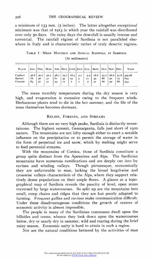
From observations taken at the rainfall station at Cagliari be- tween I856 and I9I6 sufficient data have been gathered to enable us to arrive at certain generalizations concerning the rainfall of Sardinia. Table I shows the mean monthly and annual rainfall at Cagliari, at Sassari in the northwestern part of the island (altitude 225 meters; 27 years of observations), and at Catania in Sicily (35 years). Al- though the summer rains at Cagliari are in quantity equal to those of Catania, in the latter place there is somewhat more rain during the months following the summer. The engineer Omodeo, therefore, does not exaggerate when he asserts that from the point of view of agri- cultural meteorology, the region of Campidano in Sardinia is the least favored of the entire kingdom. Even Foggia itself in "dry Apulia," which receives the minimum precipitation of continental Italy, enjoys a far more favorable seasonal distribution than that of Cag- liari. The rainfall between April and September at Foggia amounts to I98 mm. as compared with only I24 mm. at Cagliari.
The irregularity of precipitation in Sardinia is evident when we compare the two extremes, a maximum of 86o mm. (34 inches) and
'For a study of the physiography of Sardinia in relation to settlement and economic life see Erwin Scheu: Sardinien: Landeskundliche Beitrage, Mitt. Gesell. fur Erdkunde zu Leipzig I9I9-I922, Leip- Zig, I923, pp. 32-I02.
395
This content downloaded from 62.122.76.93 on Fri, 9 May 2014 08:54:29 AMAll use subject to JSTOR Terms and Conditions
396 THE GEOGRAPHICAL REVIEW
a minimum of I33 mm. (5 inches). The latter altogether exceptional minimum was that of I9I3 in which year the rainfall was distributed over only 50 days. On rainy days the downfall is usually intense and torrential. The rainfall regime of Sardinia is not paralleled else- where in Italy and is characteristic rather of truly desertic regions.
TABLE I-MEAN MONTHLY AND ANNUAL RAINFALL IN SARDINIA
(In millimeters)
PLACE JAN. FEB. MAR. APR. MAY JUNE JULY AUG. SEPT. OCT. Nov. DEC. YEAR
Cagliari 46.6 40.7 50.2 38.2 29.7 I8.4 3.2 5.9 28.6 55.7 66.6 5I.8 435.06
Sassari 66 46 5I 6i 45 25 5 I2 39 86 92 75 603 Catania 83 57 5I 34 I7 7 2 9 3I 66 go 86 533
The mean monthly temperature during the dry season is very high, and evaporation is excessive owing to the frequent winds. Herbaceous plants tend to die in the hot summer, and the life of the trees themselves becomes dormant.
RELIEF, FORESTS, AND STREAMS
Although there are no very high peaks, Sardinia is distinctly moun- tainous. The highest summit, Gennargentu, falls just short of I920
meters. The mountains are not lofty enough either to exert a notable influence on the precipitation or to permit the storage of water in the form of perpetual ice and snow, which by melting might serve to feed perennial streams.
With the mountains of Corsica, those of Sardinia constitute a group quite distinct from the Apennines and Alps. The Sardinian mountains have numerous ramifications and are deeply cut into by ravines and winding valleys. Though picturesque, economically they are unfavorable to man, lacking the broad lengthwise and crosswise valleys characteristic of the Alps, where they support rela- tively dense populations on their ample floors. A glance at a topo- graphical map of Sardinia reveals the paucity of level, open zones traversed by large watercourses. So split up are the mountains into small, steep chains and ridges that they are but poorly adapted to farming. Frequent gullies and ravines make communication difficult. Under these disadvantageous conditions the growth of centers of economic activity is almost impossible.
The people in many of the Sardinian communes dwell upon the hillsides and crests, whence they look down upon the watercourses below, dry or nearly dry in summer, wild and roaring during the brief rainy season. Economic unity is hard to attain in such a region.
Nor are the natural conditions bettered by the activities of man
This content downloaded from 62.122.76.93 on Fri, 9 May 2014 08:54:29 AMAll use subject to JSTOR Terms and Conditions
10
SARDINIA O Water power plants Scale 1: 1,700,000 * Steam KILOMET ERS
0 Transformer stations 70,000 to 15,000 volts . V 0 0 20 30 40 0
* lOOGO~~~~5,00volts 7 ~ i 0 2 30
_ Transmission lines 70,000 ME
, , 11 1' ............. 15,000
- Section stations
H: W G A~~~~~~~~L LU R A 41 LUL F - < m - - - - - 41-
Po oves eCoghins
THEGES g REV W,JuaY 020 oft Aghiero of t umo i u
t /onorvao gi
charar of t n el toro c re wt be
7B A I A
-40 183 m. 40GtREJ-
G u / X Foreta~~~~~~~~naramino a L2nuset
X;/ arrub S $1
Vil i I
Porto-vves,acnevolns
. . ,- - , -, ~~~~~~~~~~Sem-i-permeable
LTHE GEOGR. REYtEW; JULY'I926 ....(Quate nary).
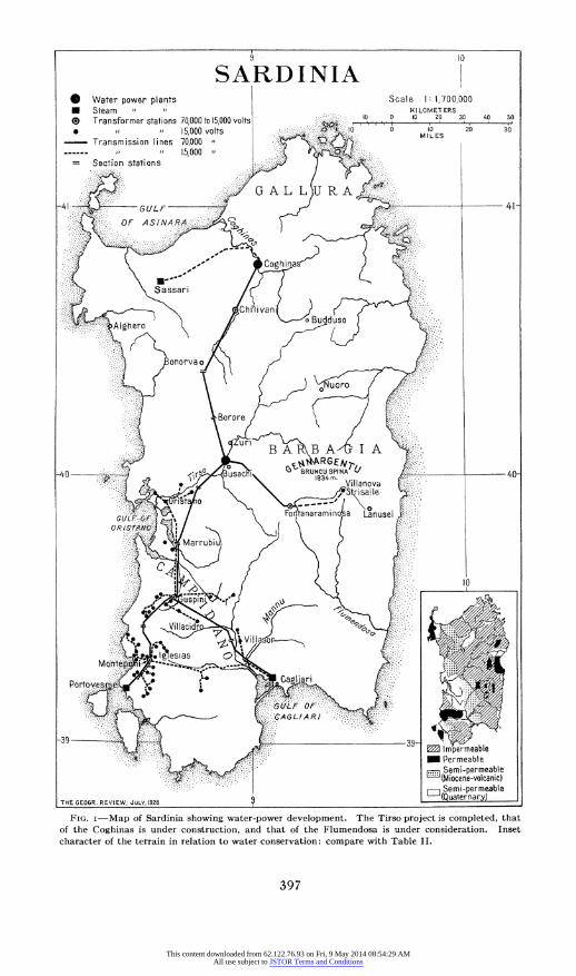
FIG. I-Map of Sardinia showing water-power development. The Tirso project is completed, that of the Coghinas is under construction, and that of the Flumendosa is under consideration. Inset character of the terrain in relation to water conservation: gcompare with Table II.
397
This content downloaded from 62.122.76.93 on Fri, 9 May 2014 08:54:29 AMAll use subject to JSTOR Terms and Conditions

398 THE GEOGRAPHICAL REVIEW
himself. Great wooded tracts have been devastated by unintelligent deforestation. Attempts at reforestation have encountered enormous difficulties owing to the lack of foresightedness on the part both of people and government. The quality of the rocks, resistant to weather- ing and decomposition; the poverty of the vegetation and its com- plete absence on some of the steepest slopes; the hot, dry, rainless summers and windy winters-a climate inimical to small plant life; the abandonment of the greater part of the soil to the simplest sort of pasturage with all the attendant abuses of an industry intolerant of restriction or discipline; and finally, insufficient financial means: these are all independent and insuperable obstacles to reforestation. When we understand them we are confirmed in our view that the forests of Sardinia do not exert any appreciable influence on stream flow at the present time and that not much may be expected of them in this respect for a long while to come.
The plains of Sardinia are of limited extent. As one goes from the coast into the interior, they succeed one another ranging from marshy and malarial lowlands near the sea to high and dry plateaus. The largest plain is that of Campidano in the southwestern part of the island. On the whole, the relief does not favor agriculture either in the mountains or on the plains.
Nor does the hydrography of Sardinia make up for the disadvan- tages of the relief. The watercourses can scarcely be said to have any definite regimes. Their periods are extremely irregular. Full and swirling, occasionally bringing ruin and disaster in the brief winter season, the waters virtually disappear during spring, summer, and most of the autumn. Then the channels are transformed into unhealthy swamps; or frequently the streams go dry altogether, leaving only melancholy traces of water in the deepest hollows. More- over, the torrential character of the Sardinian rivers has been growing more marked during the last century. There has been a progressive lowering of the average water levels, and, conversely, floods have occurred of a violence previously unknown. This has resulted partly from the destruction of the forests by man and fire and partly from the extensive cultivation of steeply sloping fields which would have been left alone under a well-understood agricultural and social policy.
The water power of the island cannot be directly harnessed for industrial purposes owing to the torrential character of the streams. Extensive modifications of the stream flow are necessary, as otherwise no power would be available during at least a half of each year. Nor are the streams of any use for the transportation of human beings and freight, or for the floating of timber. They are an obstacle to communication. They hamper the construction of works of public utility and threaten those already completed.
This content downloaded from 62.122.76.93 on Fri, 9 May 2014 08:54:29 AMAll use subject to JSTOR Terms and Conditions
WATER CONSERVATION IN SARDINIA 399
PERMEABILITY OF THE GROUND AND RUN-OFF OF WATER
The engineer Omodeo has divided Sardinia from the point of view of the permeability of the ground, into four areal categories (Fig. I). These are:
Impermeable terrains . . . . . . . . . . . . . I4,500 square kilometers (6o%) Permeable terrains . 2,000 ( 8%) Semi-permeable terrains (Miocene-volcanic) . . . 4,300 (i8%) Semi-permeable terrains (Quaternary) . . . . . 3,290 (I4%)
The impermeable areas, it is seen, cover the greater part of the island.
The permeable areas, though they are made up of terrains of very different geological ages and are scattered widely throughout Sar- dinia, are limited in their total extent. The most permeable areas are the smallest of all, covering hardly more than I50 square kilometers. The rain water falling upon these tracts for the most part disappears into the ground, offering no hope of its recovery for utilization.
The semi-permeable areas occupy 32 per cent of the total surface of the island and constitute the best agricultural lands, because of the physical and chemical composition and the thickness of their soils and because these tracts tend to be level.
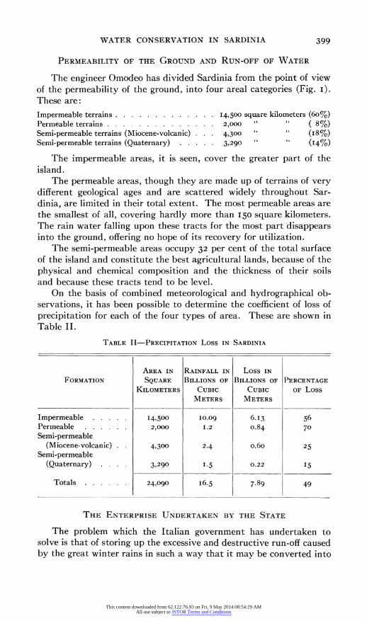
On the basis of combined meteorological and hydrographical ob- servations, it has been possible to determine the coefficient of loss of precipitation for each of the four types of area. These are shown in Table II.
TABLE II-PRECIPITATION Loss IN SARDINIA
AREA IN RAINFALL IN Loss IN
FORMATION SQUARE BILLIONS OF BILLIONS OF PERCENTAGE
KILOMETERS CUBIC CUBIC OF Loss METERS METERS
Impermeable . . . . . 14,500 10.09 6.13 56 Permeable . . . . . . 2,000 1.2 o.84 70 Semi-permeable
(Miocene-volcanic) . 4,300 2.4 o.6o 25
Semi-permeable (Quaternary) . 3,290 1.5 0.22 15
Totals . . . . . . 24,090 16.5 7.89 49
THE ENTERPRISE UNDERTAKEN BY THE STATE
The problem which the Italian government has undertaken to solve is that of storing up the excessive and destructive run-off caused by the great winter rains in such a way that it may be converted into
This content downloaded from 62.122.76.93 on Fri, 9 May 2014 08:54:29 AMAll use subject to JSTOR Terms and Conditions

400 THE GEOGRAPHICAL REVIEW
a continuous run-off, constant throughout the year. In order to accomplish this the government is undertaking the construction of a series of great artificial reservoirs.
Studies carried out by engineers have shown that of all parts of Italy Sardinia is best adapted to the establishment of such reservoirs.
Relief, geological struc- ture, and the charac- ter and course of the streams combine to pro- duce numerous basins which are easily con- verted into lakes be- cause of their position 'and levels and because of the impermeability of the ground. Materi- als for use in construc- tive operations are also readily available. All this makes it possible to build dams and dikes at a low cost.
The basic geological formations, consisting of ancient granites and schists, impermeable, resistant, and compact, although they may fa- vor the useless run-off of the rain waters, are distinctly advanta- geous from the point of
FIG. 2-The Tirso dam during the course of construction. view of measures to be taken for its conserva-
tion. This is evident when we compare the situation in Sardinia with that in the Muro Lucano basin of Basilicata. In the latter, after the water has reached a certain level owing to the permeability of the ground, it will rise no higher. No amount of investigation has served to reveal the subterranean course which it takes. In the Tirso basin of Sardinia, on the other hand, a basin which occupies a very extensive area, the coefficient of loss through subterranean channels is almost zero.
The valleys of the Sardinian rivers, such as the Tirso, Coghinas, Flumendosa, Mannu, Temo, and Cedrino, are alternately broad and deeply incised according as the rocks vary in hardness. This favors
This content downloaded from 62.122.76.93 on Fri, 9 May 2014 08:54:29 AMAll use subject to JSTOR Terms and Conditions
WATER CONSERVATION IN SARDINIA 40I
the impounding of lakes in the basins formed on the softer rocks. Omodeo has shown that under favorable technical and economic con- ditions more than 500,000,000 kilowatts (the equivalent of 580 per inhabitant) might be produced by the water power derived from the outflow of such lakes. This is twice as much power in proportion to the population as that developed in Lombardy, the most highly industrialized part of all Italy.
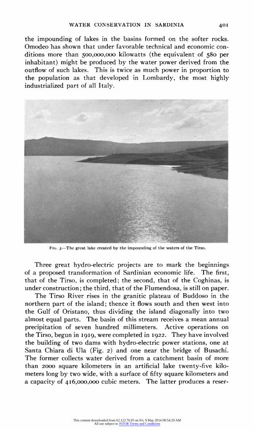
FIG. 3-Thie great lake created by the impounding of the waters of the Tirso.
Three great hydro-electric projects are to mark the beginnings of a proposed transformation of Sardinian economic life. The first, that of the Tirso, is completed; the second, that of the Coghinas, is under construction; the third, that of the Flumendosa, is still on paper.
The Tirso River rises in the granitic plateau of Buddoso in the northern part of the island; thence it flows south and then west into the Gulf of Oristano, thus dividing the island diagonally into two almost equal parts. The basin of this stream receives a mean annual precipitation of seven hundred millimeters. Active operations on the Tirso, begun in i9i9, were completed in I922. They have involved the building of two dams with hydro-electric power stations, one at Santa Chiara di Ula (Fig. 2) and one near the bridge of Busachi. The former collects water derived from a catchment basin of more than 2000 square kilometers in an artificial lake twenty-five kilo- meters long by two wide, with a surface of fifty square kilometers and a capacity Of 416,000,000 cubic meters. The latter produces a reser-
This content downloaded from 62.122.76.93 on Fri, 9 May 2014 08:54:29 AMAll use subject to JSTOR Terms and Conditions

402 THE GEOGRAPHICAL REVIEW
voir of about 2,000,000 cubic meters capacity. The formation of the larger lake has submerged the old village of Zuri, the population of which has been dispersed partly into the neighboring communes and partly into a new village built at a higher level. The new village church, a structure of considerable artistic beauty, was constructed out of the materials of the old church.
The operations on the Coghinas in southern Sardinia are on a smaller scale. An artificial lake will be formed with a surface of about i8oo square kilometers and a capacity of 254,000,000 cubic meters. The plant on the Coghinas will be united electrically with that on the Tirso in such a way that the one may supplement the other in case of need. It is expected that the Coghinas enterprise will be completed in 1926.
The Flumendosa project will be of even greater importance than the other two.
To no other region than Sardinia are the words of Besnard more appropriate: "a garden with water, without water a desert." The reservoirs already finished and proposed are intended to liberate from desertic conditions a region situated in the very heart of the Mediterranean. They are intended to conserve and discipline what are unquestionably very great hydraulic resources. They are intended to do away with the many existing evils. The work should not only bring about a positive economic advance but a veritable revolution, especially in so far as the problem of the eradication of malaria is concerned.
This content downloaded from 62.122.76.93 on Fri, 9 May 2014 08:54:29 AMAll use subject to JSTOR Terms and Conditions