waste disposal problems near potash mines in ...hydrologie.org/redbooks/a103/iahs_103_0191.pdfwaste...
TRANSCRIPT

Groundwater Pollution ~ Symposium Pollution des Eaux Souterraines (Proceedings of the Moscow Symposium, August 1971; Actes du Colloque de Moscou, Août 1971): IAHS -AISH Publ. No. 103, 1975.
Waste disposal problems near potash mines in Saskatchewan, Canada
J. A. Vonhof
Abstract. Conservative estimates of the total volume of waste generated annually by the ten potash mines in Saskatchewan, operating at full production, are 15-25 million tons of solid waste, and 800-1000 million US gallons (3.0-3.8 million m 3 ) of brine. Both the solid waste and the brine consist primarily of NaCl. Waste brine production per unit ton of product is higher in south-eastern than in central Saskatchewan because of an increase in carnallite (KCl.MgCl2.6H20) content in the ore mined in south-eastern Saskatchewan.
Both the solid waste and the brine are stored on the surface near the plants in waste disposal basins which are artificially constructed lagoons and/or natural depressions. One mine located in south-eastern Saskatchewan uses deep-well injection to dispose of excess brine in conjunction with surface storage.
The waste disposal basins are underlain by Pleistocene sediments. Except for one mine west of Regina all mines are located near major undeveloped freshwater aquifer systems. The sand and gravel of the majority of the aquifers were deposited during Pleistocene times.
Infiltration of brine from the waste disposal basins into the underlying sediments and subsequent incorporation into the groundwater flow system presents a potential hazard of contamination of the groundwater resources in the immediate vicinity of the mines. Ultimately, if pollution of groundwater cannot be contained, the contaminants may reach the Saskatchewan and Assiniboine River systems. The immediate problems to be solved by the potash industry are, therefore: how to determine the hydrological environment in which the waste disposal basins are situated, and how to continuously monitor the environment to determine the extent and the rate of movement of infiltrating brine. Long-term measures to be considered and implemented by the industry are waste volume reduction, control of the spread of contaminants by artificial, fluid-potential control and manipulation, or alternative disposal methods such as deep-well injection. Failure by the industry to overcome these potential problems at the outset may lead to irreversible, large-scale pollution of water resources, within and outside the province of Saskatchewan.
Results obtained from studies near two potash mines in south-eastern Saskatchewan will be used to illutrate several of the problems.
Résumé. Les évaluations au bas mot du volume de déchets produit annuellement par les 10 mines de potasse à Saskatchewan, fonctionnant en pleine capacité de production, sont 15-25 millions de tonnes de déchets solides, et 800-1000 millions de gallons US (3.0-3.8 millions m3 ) de saumure. Les déchets solides ainsi que la saumure se composent principalement de N a d . La production de déchets de saumure par tonne unitaire du produit est plus élevée au sud-est qu'au centre de Saskatchewan à cause d'un augmentation dans la tenur en carnallite (KCl.MgCl2 .6H2 O) dans le minerai extrait au sud-est de Saskatchewan.
Les déchets solides ainsi que la saumure sont mis en dépôt à la surface près des installations dans des bassins pour l'élimination des résidus, lagunes artificiellement construites ou des creux naturels. Une mine située au sud-est de Saskatchewan utilise l'injection de forage profond pour écouler les déchets de saumure de concert avec la mise en dépôt à la surface.
Les bassins pour l'élimination des résidus reposent sur des sédiments du Pleistocene. A part une mine à l'ouest de Regina toutes les mines sont situées près des principales couches aquifères d'eau douce et des systèmes aquifères. Le sable et le gravier de la majorité des couches aquifères étaient déposés pendant l'ère Pleistocene.
L'infiltration de la saumure des bassins pour l'élimination des résidus dans les sédiments sous-jacents et l'incorporation subséquente dans le système d'écoulement souterrain présentent un risque latent de contamination des ressources d'eaux souterraines dans le voisinage immédiat des mines. En fin de compte, si la pollution des eaux souterraines ne peut pas être maîtrisée, les matières contaminantes pourront gagner les réseaux fluviaux de Saskatchewan et de l'Assiniboine. Donc les problèmes urgents à résoudre pour l'industrie de la potasse sont: la détermination des environments hydrologiques dans lesquels les bassins pour l'élimination des résidus sont situés et l'enregistrement continu dans les environnements pour déterminer l'étendue et la vitesse du

192 J. A. Vonhof
mouvement de la saumure infiltrante. Des mesures à long terme à considérer et à rendre effectifs par l'industrie sont la réduction du volume des déchets, le contrôle de la propagation des matières contaminantes par le contrôle et la manipulation du potentiel fluide, ou des méthodes alternatives d'élimination des résidus telles que l'injection de forages profonds. La non-réussite de l'industrie à vaincre ces problèmes latents dès le début pourra aboutir à la pollution sur une grande échelle des ressources d'eau à l'intérieur et à l'extérieur de la province de Saskatchewan.
Les résultats obtenus par la suite des études près de deux mines de potasse, au sud-est de Saskatchewan seront utilisés pour illustrer plusieurs des problèmes.
INTRODUCTION
An attempt is made here to synthesize the waste disposal problems of the potash industry in the Province of Saskatchewan, Canada. The problems are related to the type of ore mined and to the environment in which the waste disposal basins are situated. Ten mines are at present mining potash in the Devonian Prairie Evaporite Formation in Saskatchewan.
Location of the Province of Saskatchewan The Province of Saskatchewan is located in the northern part of the western interior region of the North American continent. Saskatchewan is the centre province of the three prairie provinces in western Canada (Fig. 1). The location of the potash mines is shown in Fig. 2.
Most of Saskatchewan, except for some areas near the United States border, has a level to gently rolling topography. The average annual precipitation is between 12 and 16 in. (305-405 mm). Most of the annual precipitation, 50 to 70 per cent, occurs during the summer season. The climate varies from BSK or Cold Steppe Climate in south-western Saskatchewan to Dfb or Cold 'Forest' Climate in the central part of the province (Richards and Fung, 1969).
FIGURE 1. Location of the Province of Saskatchewan, Canada.

Waste disposal problems near potash mines in Saskatchewan, Canada 193
u
T3
.g C o
o ft.
3
l
O
W Pi D O E

194 J. A. Vonhof
GENERAL STRATIGRAPHY OF THE PRAIRIE EVAPORITE FORMATION
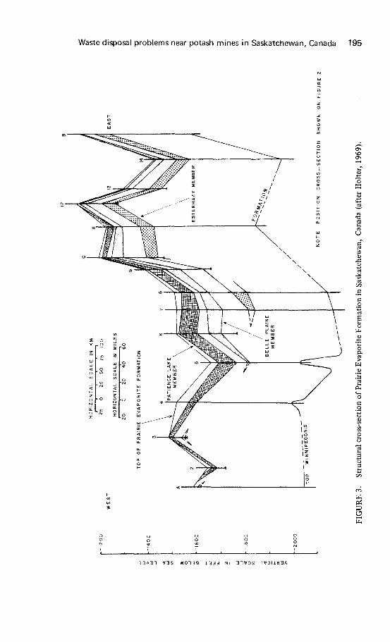
The Prairie Evaporite Formation is part of the Upper Elk Point Group of Middle Devonian age. The formation is one unit in the third of five major Middle Devonian evaporite cycles which were deposited in the Elk Point Basin. The Elk Point Basin extended from northern Alberta into the northern part of the United States of America. The distribution of the Prairie Evaporite Formation is shown in Fig. 2. The Prairie Evaporite Formation is underlain in Saskatchewan by dolomites of the Winnipegosis Formation. This formation is also part of the Elk Point Group. The 'Second Red Beds', constituting the basal strata of the Dawson Bay Formation of Middle Devonian age, overlie the Prairie Evaporite Formation in Saskatchewan. The 'Second Red Beds' consist of thick-bedded, red shales, highly dolomitic in part. Only in the Saskatchewan part of the basin, situated at the south-eastern extremity of the Elk Point Basin, has significant accumulation of potash taken place in -the Prairie Evaporite Formation (Holter, 1969).
Three main potash members are recognized in the upper part of the Prairie Evaporite Formation in Saskatchewan. These are named in ascending order: the Esterhazy, Belle Plain and Patience Lake Members (Fig. 3). Intervening halite units are unnamed and contain little or no potash (Holter, 1969). The average depth to the mining level is 3200 ft (960 m) below ground surface.
The three mines in south-eastern Saskatchewan are mining the Esterhazy Member, whereas the mines in central Saskatchewan, west and east of Saskatoon, are mining the Patience Lake Member. The difference between the two members from a waste producing point of view is that the Esterhazy Member contains up to 5 per cent carnallite and less than 1 per cent insolubles whereas the Patience Lake Member has up to 5 per cent insolubles and no carnallite (Holter, 1969).
PRESENT WASTE DISPOSAL TECHNIQUES AND PROBLEMS
Origin and kind of wastes Almost all of the wastes generated by the potash industry consist of NaCl, both in dissolved and solid form. The NaCl occurs as the mineral halite interspersed with sylvite (KC1) in the ore. The percentage of halite varies from 50 to 70 in the mined intervals, depending on the grade of the ore. Another minor source of halite is the so-called 'salt horse', pockets, lenses, irregular beds, or channel fills that contain halite within the ore bed. Many of the smaller 'salt horses' have to be mined for technical and economic reasons and the waste salt thus obtained is transported with the ore to the surface.
The insolubles, another type of waste, consist primarily of clays with minor amounts of anhydrite, gypsum, quartz, and carbonate minerals (Streeton, 1967). The clays are either interspersed with the ore or they occur as thin layers in the ore bed. The other minerals are generally interspersed with the ore.
A third source of waste, present in the ore, is the mineral carnallite (KCl.MgCl2.6H2 O). The carnallite occurs interspersed and/or as pockets and lenses in the ore (Wardlaw, 1968; Baar, 1971, pers. comm.). The MgCl2 in the carnallite is undesirable in the finished product and is removed by selective solution in the mill.
Three other sources of waste, mainly liquid, are 'wash' water in the mill, shaft water, and spent mill chemicals. All these wastes from the various sources, are discharged in a waste disposal basin. Figure 4 summarizes the origin and kind of waste. The volume of brine generated by the different mines varies from less than 100 US gpm (380" l./min) to 500 US gpm (1900 l./min). In general the volume of brine generated by the mines in south-eastern Saskatchewan is 1.5-2 times as high per ton of product as the volume of brine produced by the mines in central Saskatchewan. This is the result of a relatively high carnallite content in the ore (1 to 5 per cent/ton) in
Waste disposal problems near potash mines in Saskatchewan, Canada 195
Œ
O
o ft.
!
a
13A33 Ï3S M0T38 i 3 3 3 NI 31 Ï3S 1VDIJ.H3A

196 J. A. Vonhof
HAUTE (NoC!) interspersed
witft syivi te, 5 0 " 7 0 % N a C I / T o n
INSOLUBLES mainly clays, interspersed with ore, or as th in layers up to
5 % / Ton
HAUTE (NoC!) from "salt horses"
CARNALLITIC ORE
(KCI MgCi 2 6 H 2 0 )
"WASH" WATER MILL
SHAFT WATER
~ \
-
SPENT MILL , . - - "
CHEMICALS
\ ^^^ \ ^ \ \ ^ ~ ^ /
\ ^-^ . ^ " \
\ \ \ \
\ \
\ ~ \ \
A
..--"*' ^
SOLID WASTE
WASTE DISPOSAL
BASIN FEED
LIQUID WASTE
FIGURE 4. Kind and origin of wastes in the Saskatchewan potash industry.
south-eastern Saskatchewan (Holter, 1969; Miiller, 1971, pers. comm.). The ore mined by the various companies in central Saskatchewan is essentially free of carnallite but contains a higher percentage of insolubles.
The ratio of solid waste to finished product is approximately 1.5, i.e. for each ton of finished product 1.5 tons of solid waste (halite) is produced.
The total volume of waste that would be generated annually by the 10 potash mines operating at full production capacity, is conservatively estimated to be 15-25 million tons of solid waste and 800-1000 million US gallons (3.0-3.8 million m3 ) of brine. The required surface storage volume for the liquid waste alone is approximately 3400 acre feet per year. At present potash production levels, however, the volume of waste is about 50 per cent of the above-quoted figures.
Waste disposal techniques The waste, both solid and liquid, from the mill and other sources is pumped as a slurry into the waste disposal basins. The waste disposal basins consist of artificially constructed lagoons and/or natural depressions (Fig. 5). The size of the artifically constructed lagoons varies from 200 to 900 acres (80 to 365 ha). The solid particles in the slurry build 'aEuvial' fans above and deltas below the brine level from the point of discharge in the waste disposal basin. One mine, International Mineral and Chemical Corporation, Kl potash mine near Esterhazy, Saskatchewan, uses deep-weË injection in conjunction with surface storage. Deep-weË injection of brine is under consideration by several other mining companies.
Waste disposal problems In Saskatchewan the industry is not allowed to discharge brine at any time during the year into bodies of fresh water, as was allowed, for example in East Germany in the Werra river until 1966 (Poschke, 1965). The companies must, therefore, retain the waste on the mine property in waste disposal basins or dispose of the waste by other means, for example by backfill of the solid waste in mined areas (not practised), and deep-well injection of liquid waste. The biggest disadvantage of the present waste

Waste disposal problems near potash mines in Saskatchewan, Canada 197
a. CD
I
I
UJ
£ 03
• 1 : * - •% •
• h ' • %-ink * «' «
» -, - "̂
MS £• . .y-s-
i'î"'t-
_) <
Werner

198 J. A. Vonhof
disposal technique is a constant need for increased storage capacity of the waste disposal basins, i.e. several additions to existing lagoons must be built in future years to supply the necessary storage volume.
In waste disposal management by industry, brine volume reduction by evaporation, once thought to be an important factor, is now considered to be equal to the annual precipitation. Evaporation from brine surfaces during the summer season exceeds annual precipitation by a factor of 1.2-1.5, as shown by studies using Class A evaporation pans conducted by Maybank and Calvert (1970). However, factors such as drifting snow during most of winter into the ice-free waste disposal basins may nullify any water loss during summer.
Possibly the most serious problem of the present waste disposal technique is the potential pollution of fresh groundwater resources (Meneley, 1965). This is especially so if no alternative solutions, such as deep-well injection, are employed by industry. With each addition to the present waste disposal basins the area subjected to infiltration of brine also increases. Figure 6 shows the distribution of aquifers, aquifer systems, and the location of potash mines in Saskatchewan. The aquifers discharge at many points along their course into surface water bodies. Both the Saskatchewan and Assiniboine (Qu'Appelle) River systems receive annually a considerable volume of water from aquifer discharge. The proximity of almost all potash mines to major aquifers (Fig. 6) makes it therefore imperative that contamination of aquifers is contained in the immediate vicinity of the mines.
One factor which to some extent complicates proper management of waste disposal and of the basins is the fact that the site selection of the basins near most mines had to be carried out at a time when detailed geological knowledge of the site areas was sparse. Comprehensive hydrogeological surveys of specific site areas have subsequantly tended to indicate that the sites selected may not in all cases be the best possible from the point of view of future groundwater contamination. Two examples will be given below.
Minor problems experienced by the industry are wind-carried brine spray and dike erosion.
MONITORING AND CONTAINMENT PROGRAMMES
The object of a monitoring programme is to obtain observational information on the possible subsurface migration of brine from the waste disposal basin. The design of the monitoring system should be based on a properly evaluated hydrogeological environment. Three functions are served by a monitoring programme. These are:
(1) To observe the hydraulic gradient along the most permeable paths away from the waste disposal basin
(2) To observe the rate of brine movement along the most permeable flow paths (3) To obtain the information necessary to take suitable remedial action to control
the migration of waste products
Information on changes in the groundwater levels in the vicinity of a waste disposal basin can be obtained from observation wells. Observation wells are generally capable of producing sufficient water for chemical analysis and serve therefore a dual purpose.
The position and shape of a brine front advancing in the direction of groundwater flow can be determined by several methods. These methods are:
(1) Sequential water sampling of observation wells for analysis; this will show changes in the chemical quality of the formation water, due to the advancing brine front
(2) Drilling, electric logging and sidehole coring of test holes at desired intervals;

Waste disposal problems near potash mines in Saskatchewan, Canada 199
AREAS OF MAJOR AQUIFERS
Hatfield Valley aquifer system
Preglacial valley aquifer systems
Bedrock sand aquifers
Glacial sand aquifers
AREAS OF MINOR AQUIFERS
n Predominantly bedrock sand aquifers
Predominantly glacial sand aquifers
106° 104* 20 _ 0 _ 2 0 40 60 BO 100 Miles
S C A L E
50 50 100 Km
FIGURE 6. Distribution of aquifers and aquifer systems in Saskatchewan, Canada (modified after Christiansen and Whitaker, 1970).
analysis of the electric logs in conjunction with leachate analysis of the sidehole cores would determine the vertical configuration of the brine front
(3) Sequential surface resistivity surveys, which can be used to delineate the brine front and which would provide more continuous coverage between adjacent point sources that can be obtained by the other methods

200 J. A. Vonhof
The actual design of a monitoring programme should be based on a detailed knowledge of the unique hydrogeological environment in the vicinity of the waste disposal basin. The type or combination of methods used for a particular waste disposal basin is determined by a cost-benefit analysis of the various methods.
The most important function of the monitoring programme is to obtain the information necessary to determine when remedial action must be taken to limit the spread of subsurface pollutants. The objective of remedial action is containment of waste, which could be realized either by reducing the permeability of the most permeable flow paths or by manipulating and controlling the direction and magnitude of the hydraulic gradient along the most permeable flow paths ('hydrodynamic containment'). Permeability reductions could be achieved by the construction of cut-off walls, such as slurry trenches and grout curtains. The hydraulic gradient can be manipulated by pump or injection wells.
Analogue or digital model studies of the hydrological environment in which the waste disposal basin is situated will be necessary, to aid in the design of a containment programme and to determine which method or combination of methods should be adopted.
GENERAL PLEISTOCENE STRATIGRAPHY
All waste disposal basins near the various potash mines are underlain by glacial drift deposits of Pleistocene age. The drift deposits comprise all sediments overlying 'bedrock' which, in most of southern Saskatchewan, consists of sediments such as clays, shales, silts, and sands of Upper Cretaceous age. The Pleistocene drift deposits comprise till, clay, silt, sand, gravel, and various admixtures depending on the mode of deposition. The drift thickness varies from less than 1 ft (30 cm) to greater than 1000 ft (300 m) with an average of 300 ft (90 m) in the southern half of Saskatchewan (Whitaker, pers. comm.).
Figure 7 shows a generalized and composite stratigraphie section of the Pleistocene sediments and the type and possible position of aquifers. The aquifers and aquifer systems (see also Fig. 6) are the most important units in the Pleistocene section. Not only do the aquifers constitute potential fresh water resources of great magnitude, they also represent the permeable paths for the migration of liquid waste. Most surface water bodies, for example, receive a considerable volume of water through discharge from these aquifers. The origin of the aquifers, their position in the section, areal extent, development, type and uniformity of sediment, and interrelationship is directly related to the glacial history of the Pleistocene epoch. It is therefore of utmost importance for the protection of the environment from large-scale irreversible pollution that the stratigraphie framework is known in sufficient detail both on a local and regional scale. However, the stratigraphie relationships within the Pleistocene section are generally complex, and abrupt faciès changes, both vertically and horizontally, are common. Due to lack of surface exposure, extensive test drilling programmes have to be conducted on a regional and local scale, such as near waste disposal basins, to obtain the detailed stratigraphie information necessary to define and correlate the various lithologie units that constitute the geological model. Information on the regional stratigraphy in the southern 100,000 square miles (258,000 km2) in Saskatchewan has been compiled by the Saskatchewan Research Council.
Excellent studies on regional Pleistocene stratigraphy were conducted by Christiansen (1967, 1968 a, b, 1969). These studies greatly facilitate the correlation of local to regional stratigraphy.
A proper definition of the stratigraphie framework is a prerequisite to understand, determine and evaluate the effects of the waste disposal basins on the environment.

Waste disposal problems near potash mines in Saskatchewan, Canada 201
dnoys NOOXVXSVS
i°-J
dnoas aN»ia3Hins
1\
sno30Vi3&o aaddn
.sa
S o c
S
o o. S o U
W
S

202 J. A. Vonhof
WASTE DISPOSAL BASIN AT INTERNATIONAL MINERALS AND CHEMICAL CORPORATION (CANADA) LTD., K2 PLANT, NEAR ESTERHAZY, SASKATCHEWAN
Introduction The Inland Waters Branch is at present conducting a research project near IMCC K2 plant to study the effects of waste disposal basins on the environment. This study is carried out with full co-operation of the company.
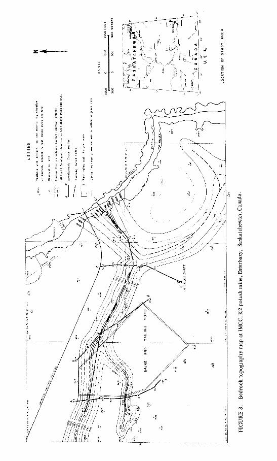
The IMCC K2 waste disposal basin is located approximately 9 miles (14 km) east of Esterhazy, in south-eastern Saskatchewan (Fig. 8), on a gently rolling till plain. The brine ponds are situated approximately 1 mile (1.6 km) west of Cutarm Creek. The elevation of the till plain around the K2 plant is about 1650 ft (502 m) above mean sea level, whereas the bottom of Cutarm Creek valley is at about 1510 ft (460 m) above mean sea level. The maximum relief in the area is approximately 140 ft (42 m).
Evaluation of existing data (before 1966) indicated the presence of thick sand and gravel deposits in the subsurface between the plant and Cutarm Creek, and during the subsequent drilling of these deposits artesian conditions were encountered. The presence of buried sand and gravel deposits, in places above the bottom of Cutarm Creek valley, the surface relief of 140 ft, and the artesian conditions strongly suggest that a significant facies change, causing a reduction in the transmissibility of the medium, has taken place between the area where sand and gravel deposits are present, and Cutarm Creek valley.
To evaluate the effects of changes in the distribution of permeable sediments in the vicinity of the waste disposal basin on the rate and direction of groundwater flow, and consequently on the rate of brine infiltration and the rate and direction of brine flow in these sediments, an extensive drilling programme was conducted to delineate these deposits and to define the geological model.
A total of 91 testholes were drilled over a 2-year period in 1969 and 1970 to obtain detailed stratigraphie information in an area of approximately 7 square miles around the waste disposal basin. Within a 1 mile radius from the brine ponds 78 testholes were drilled.
A drilling programme conducted before 1969, to define the regional geological framework, revealed that the IMCC K2 plant was located on the northern flank of a bedrock upland, and that an extensive aquifer was present within the Pleistocene section north of the upland. This aquifer is part of the glacial sand aquifer system near Melville and Yorkton in south-eastern Saskatchewan (Fig. 6).
Stratigraphy The waste disposal basin is underlain by Pleistocene sediments, which in turn overlie unconformably the Riding Mountain Formation of Upper Cretaceous age (see cross-sections A-A1 B-B| , C-C1 and D-D1, Figs. 10, 11, and 12). The Pleistocene sediments comprise tills and fluvial sediments. Two tills, the Battleford Formation, upper till, and the Floral Formation, lower till, can be recognized.
Battleford Formation. The Battleford Formation comprises friable, oxidized, calcareous sandy and silty till. The thickness varies from 6-17 ft and averages 10 ft.
Floral Formation. The Floral Formation, which underlies the Battleford Formation, consists of oxidized to unoxidized, calcareous pebbly till. The upper part of the Floral Formation is generally oxidized. The thickness of the oxidized zone ranges from 8 to 20 ft (2.5-6 m). The Floral Formation is generally fractured, with the fractures extending at least 30 ft (10 m) below the contact with the overlying Battleford Formation (Vonhof, 1971). Excellent examples of fracture patterns were found in a number of borrow pits in the south-eastern quarter of sec. 33, Tp. 19, Rg. 32, W. 1 mer. In parts of the borrow pits the vertical fractures could be traced over a vertical distance of 20 ft (6 m).
< j
c S
•fi
o u s
o
w os
g

o o s
•o c
w OS
O

Waste disposal problems near potash mines in Saskatchewan, Canada 205
!700 M . 1700
HORIZONTAL SCALE * utio«, caic, with o» joints - _ Geologic contact.
400 0 400 BOO FEET
FIGURE 10. Stratigraphie cross-section A-A1 at IMCC, K2 potash mine, Esterhazy, Saskatchewan, Canada.
West of sections 26 and 35, Tp. 19, Rg. 32, W. 1 mer., the thickness of the Floral Formation ranges from 15-100 ft (4.5-30 m) and averages approximately 35 ft (10.5 m). The Floral Formation rests either on the Riding Mountain Formation or on fluvial deposits in that area. East of sections 27 and 34, Tp. 19, Rg. 32, W. 1 mer., the stratigraphie section changes drastically. A large number of thin sand and gravel beds, lenses, and irregular bodies appear in the Floral Formation in this area. Furthermore, the thickness of the Floral Formation increases significantly. As can be seen on cross-section D-D1 (Fig. 12) the total combined thickness of the tills underlying the Battleford Formation just west of Cutarm Creek is approximately 250 ft (75 m). Thicknesses of 100 ft (30 m) are common in this area.
Fluvial Deposits. The fluvial deposits comprise silt, sand, polymict gravel, and gravel comprising mainly siliceous shale pebbles. Generally the grains and pebbles in the individual beds are well sorted and subangular to subrounded. The sand sizes range from very fine to very coarse with medium sizes predominating. (Note: metric scale was used to classify clastic particles: v. coarse 1-2 mm, coarse 0.5-1 mm, medium 0.25-0.5 mm, fine 0.125-0.25 mm, and v. fine 0.0625-0.125 mm). The gravels vary in size from 2 mm to 40 mm. The shale-pebble gravel beds consist of subrounded to rounded siliceous shale fragments which were derived from the Riding Mountain Formation. The pebbles range in size from 2 mm to at least 50 mm. The shale pebbles are generally embedded in sandy matrix. Several of the very coarse grained sands consist entirely of rounded to well-rounded shale particles.
The fluvial deposits occur as extensive valley fills (Figs. 9, 10, 11, and 12) west of sections 26 and 35, Tp. 19, Rg. 32, W. 1 mer., and underlie the Floral Formation. The deposits rest unconformable on the Riding Mountain Formation. A thickness of 250 ft (75 m) of sand, gravel, and shale-pebble gravel was encountered in a testhole west of the brine pond. East of sections 27 and 34, Tp. 19, Rg. 32, W. 1 mer. the fluvial deposits occur as thin layers and lenses, interbedded with till layers.
The most significant change occurs in the reach of the buried valley near Cutarm Creek (Figs. 9 and 12). Thick deposits of till with minor amounts of sand and gravel

206 J. A. Vonhof
30 METERS
FIGURE 11. Stratigraphie cross-sections B-B1 and C-C at IMCC, K2 potash mine, Esterhazy, Saskatchewan, Canada.
constitute the valley fill. The tills and sand and gravel were most likely deposited by ice-thrusting in an existing valley which was located on the north slope of a bedrock upland.
Ice thrusting is common in those areas in Saskatchewan where pre-Pleistocene bedrock uplands (with or without existing valleys) were present (Whitaker, 1971, pers. comm.). Kupsch (1962) has described several examples of ice thrusting in pre-existing valleys of the pre-Pleistocene Missouri Coteau. The Missouri Coteau is a major physiographic feature that runs diagonally across the southern part of the province.
Riding Mountain Formation. The Riding Mountain Formation of Upper Cretaceous age comprises non-calcareous, grey, unoxidized mudstone, and siliceous shale. In places the formation contains beds of very fine grained, silty, greenish grey, non-calcareous to slightly calcareous sands.

u
•I
o o
§
. 9
w pi
o
3«0«* i 3 3 i NI *0 i r rAÎT3

208 J. A. Vonhof
Bedrock topography The bedrock topography constitutes the interface between the Pleistocene sediments and the Riding Mountain Formation (Fig. 8). The basic data to construct this surface were obtained from testholes. As can be seen in Fig. 8, a narrow and deep valley traverses the study area from west to east. The western and eastern extent of this main valley outside the study area is not known. The main valley runs under the northern part of the brine pond. Two tributaries join the main valley. One starts approximately 0.5 mile west of the brine pond in sections 28 and 33, Tp. 19, Rg. 32, W. 1 mer., and continues eastward under the brine pond where it joins the main valley. The other tributary starts in the south-eastern part of the study area and joins the main valley in the north-eastern quarter of section 27, Tp. 19, Rg. 32, W. 1 mer., and is for its entire length outside the brine pond area. Little or no bedrock relief is present in the areas outside the valleys.
Monitoring programme and hydrological data Seven observation wells have been installed near the brine pond. The inside diameter of the well casing is 6.5 in. (16.5 cm) and all wells are instrumented with water level recorders with a 5 in. (12.7 cm) diameter float. All casings are cemented and the wells are completed with 4 in (11.6 cm) stainless-steel screens. Six wells were completed in the upper part of the aquifer and one well next to a shallow well east of the brine pond was completed in the lower part of the aquifer (Fig. 13). This was done to obtain information on the vertical gradient within the aquifer. The difference between water levels in the shallow and deep well (0.01 ft or 3 mm) shows that there is only a very small vertical gradient. The location of the wells is shown in Fig. 8.
The proximity of the brine pond to Cutarm Creek necessitated an adequate definition of the hydrological environment in the area between the waste disposal basin (brine pond) and Cutarm Creek. Six of the seven wells were therefore installed in the main buried valley east of the brine pond and the seventh well was located west of the brine pond.
A pump test was run on each well and the drawdown was recorded simultaneously in the other wells. Detailed interpretation of the results has not been completed at this time. However, preliminary evaluation of the results shows that the main valley under the brine pond constitutes hydrologically a continuous system. Pumping of each individual observation well caused drawdown in all other wells.
The permeability of the completion zone of the various observation wells was determined by response tests as described by Cooper et al. (1967). The permeability values obtained by this method range from 10 cm/s to 0.005 cm/s. These values are consistent with the texture of the sand in the completion zone. No permeability values for the tills have as yet been determined. However, other workers (Meneley, 1970; Meyboom, 1967; Freeze, 1969) show that the permeability of till generally lies within the 10^4-10~"7 cm/s range. Permeability values for the 'surface' till (Battleford Formation) according to Meyboom (1967) range from ÎO^-IO"5 cm/s. The permeability of the tills underlying the Battleford Formation, such as the Floral Formation, is generally considered to be in the 10~5-10~7 cm/s range. However, the Floral Formation is highly jointed, and excellent, well-oriented, vertical, joint patterns are present (Vonhof, 1971). These joints could increase the vertical permeability of the till by several orders of magnitude depending on the joint aperture and joint density.
Figure 13 shows the hydraulic gradient in the aquifer as measured on May 19, 1970. As can be seen from the hydraulic gradient, artesian conditions are present in many parts of the aquifer. This is the result of a local reduction in the longitudinal permeability of the aquifer near Cutarm Creek. Discharge conditions in the area west of Cutarm Creek and east of the brine pond are confirmed by the presence of

i l l A •>'' V^A / %t
6
/ 1 „
I -I ° «
\ l Î \'l \ » \ I
« u v U
) -C3
•o c o o. «J
c •n ! JD
\ <*-« o +-» I W 5
3
es
I 13*31 ¥38 NV3H 3A0BV A3 3d NI M0U.VA313

210 J. A. Vonhof
perennial ponds and 'alkaline' areas. Freeze and Witherspoon (1967) have shown theoretically that a groundwater discharge area would be created at the up-gradient end of a buried permeability restriction of this type.
The significance of the longitudinal permeability restriction is that it will retard the movement of brine towards Cutarm Creek. Furthermore, if the brine is allowed to reach the area of the permeability restriction, manipulation of the hydraulic gradient can most likely be achieved by a network of low-yield injection wells in that area. This could effectively prevent the brine from reaching Cutarm Creek and the aquifer system east and north of this area.
Analogue and digital models of this hydrogeological environment will be constructed in the near future and studies using these models will be conducted to determine the optimum brine containment technique.
Conclusions Based on the geological and hydrological data obtained from test-drilling and observation wells the following conclusions can be reached:
(1) The waste disposal basin (brine pond area) is situated on top of a buried-valley system filled with permeable fluvial sediments
(2) In the eastern reach of the main buried valley a significant faciès change in the valley fill causes a drastic change in the transmissibility of the buried-valley system near Cutarm Creek
(3) Groundwater discharge is indicated in the area east of the brine pond by perennial ponds, 'alkaline' areas, and flowing testholes
(4) The presence of a permeability restriction in the buried valley, which acts as natural containment near Cutarm Creek, greatly reduces the threat of large-scale groundwater and surface water pollution in the area.
WASTE DISPOSAL BASIN AT SYLVITE OF CANADA, LTD., SOUTH-EAST OF ESTERHAZY, SASKATCHEWAN
General The Sylvite of Canada potash mine is located in south-eastern Saskatchewan near the border with Manitoba and approximately 28 miles (45 km) south-east of Esterhazy (Fig. 14A and B). The plant area is about 1 mile (1.6 km) south of the edge of the Qu'Appelle Valley.
The elevation of the mine site is about 1575 ft (472 m) above mean sea level, whereas the bottom of Qu'Appelle River Valley is at about 1300 ft (390 m) above mean sea level. The maximum amplitude of relief in the area is approximately 275 ft (82 m).
All information on this area was obtained from published reports by Christiansen (1960), Beckie and Balzer (1970), and Anonymous (1967).
Hydrogeology The potash plant and the waste disposal basin are situated on the Welby Sand Plain (Fig. 14B), a glacial outwash deposit (Christiansen, 1960). Thick and extensive sand and gravel deposits interbedded with till and clay layers constitute the Welby Sand Plain. Several aquifers, separated by tills and clays, have been recognized and mapped during an industrial groundwater investigation for Sylvite of Canada by Beckie and Balzer (1970). A number of large springs are present in the Qu'Appelle Valley, which discharge from the various aquifers.
Testhole data (Beckie and Balzer, 1970; Anonymous, 1967) in the immediate vicinity of the plant indicate that sand and gravel is present at the surface and that a

u 11 LI U '-" i
u
c
fu
\: i f
>
laiiii 01
T
i / i j
1 i i
H 4 1 1 1
( « • • ; • • • uoaut «Aoqc )««j

212 J. A. Vonhof
buried valley, filled with sand, gravel, till and clay layers, lies just east of the plant (Figs. 14CandD).
The static water level in the near-surface aquifer drops drastically towards the Qu'Appelle Valley. Near the plant the watertable is about 10 ft (3 m) below the surface. Near the edge of the valley the near-surface sand and gravel deposits are essentially dry as indicated by watertable information and by the electric logs on cross-section A-A1 (Fig. 14D). The watertable lies at the base of the sand and gravel deposits and in places at least 60 ft (18 m) below the surface. A steep hydraulic gradient toward the Qu'Appelle Valley is therefore present in the near-surface sand and gravel deposits. Cross-section A-A1 also shows that a steep downward gradient is present between the surface aquifer and the buried-channel aquifer.
The higher permeability of the surface deposits and the gradient towards the Qu'Appelle Valley present therefore problems of considerable magnitude in waste containment.
Summary The waste disposal basin at the Sylvite of Canada Ltd. mine is situated in a potentially dangerous hydrogeological environment. Brine infiltrating the aquifers could move rapidly towards the Qu'AppeËe Valley. The problems associated with the location of the waste disposal basin are, however, well recognized by the company. Everything possible has been done to minimize the threat of pollution. The brine ponds, for example, are completely lined with clay layers and heavy gauge plastic to eliminate brine infiltration. Deep-well injection of brine is planned to reduce the surface storage to a minimum. Furthermore, several containment techniques, such as grouting, are under consideration to prevent brine from polluting the freshwater resources in the area.
ALTERNATIVE WASTE DISPOSAL TECHNIQUES
If the potash industry were to continue to use present waste disposal techniques the necessary storage volume for liquid waste over a 50-year period would be in the order of 160,000 acre ft (approx. 195 million m3). This is equal to an area of 25 square miles (64.5 km2) with a layer of brine 10 ft (3 m) deep. An additional 6 square miles (15.5 km2) with a 100 ft (30 m) thick layer will be necessary to store the solid waste. These figures represent minimum values because no allowance was made for the additional waste volume generated by production increases of existing facilities and by new mines which will undoubtedly be developed in future years.
The continuous threat posed to the environment by the ever-expanding waste disposal basins will make it imperative and increasingly urgent that the wastes be managed more effectively. Furthermore, the cost of land acquisition, dike construction and maintenance, site investigation, monitoring and containment programmes will make the present disposal technique economically very unattractive.
To minimize the threat to the land surface environment the volume of waste to be stored in waste disposal basins should be reduced drastically. This could be achieved in a number of ways.
First, the industry should strive for a reduction in waste volume either by modifying existing installations or by developing new processing and perhaps new mining techniques.
Second, backfill of solid waste should be considered. Public pressure to protect the environment, and new mining techniques, for example, may make this method economically attractive in the future.
Third, disposal of liquid waste by deep-well injection. This alternative disposal technique has considerable attraction for those in the waste-management field. In

Waste disposal problems near potash mines in Saskatchewan, Canada 213
many cases it is not only technically feasible, but also economically attractive, especially when new standards for the protection of the quality of surface and groundwater necessitate extensive capital outlay for new waste-treatment and containment facilities. However, deep-well disposal of liquid waste is not the panacea for waste disposal problems, because the liquid waste is placed in an active hydro-dynamic environment where it is committed only to temporary and not permanent storage. This means that the representation of the method as either final or permanent is unrealistic and dangerous. Proper hydrogeological investigations and model studies of the disposal formation on a regional scale should be made to determine the effects of deep-well injection before its use. Subsurface disposal operations that are hastily conceived, inadequately investigated, improperly equipped and insufficiently monitored can lead to serious and often irreversible damage to the environment.
Deep-well injection of brine is practised by one potash company in Saskatchewan, IMCC Kl mine near Esterhazy, and under consideration by a number of other companies. The brine is injected into the Interlake Formation of Silurian age which underlies the Prairie Evaporite Formation. These formations lie within the Western Canada Sedimentary Basin. The basin extends from the eastern part of the Canadian Cordillera in western Alberta to the Precambrian Shield in north-eastern Alberta, northern Saskatchewan, and central Manitoba. Great accumulated thicknesses of sedimentary rocks, vast areal extent and regional structural stability represent an enormous potential for deep-well disposal of liquid waste within the basin. However, solution of salt in the Elk Point Group by local and regional groundwater flow systems (such as described by Hitchon, 1969a, b) within the basin has resulted in a large number of collapse structures and salt solution areas. The collapse structures are similar to Graben type structures and are characterized by near-vertical normal faults or high-angle step faults. The faults extend downward to the Elk Point Group. Excellent examples of collapse structures near Saskatoon and south of Yorkton in Saskatchewan were described by Christiansen (1967, 1970). The diameter of the structures varies from 1000 ft (300 m) to several miles.
The danger of the salt-collapse structures is that they could constitute highly permeable vertical paths for movement of fluids. Brine injected into a formation intersected by several collapse structures could conceivably migrate upward in these structures and pollute freshwater aquifers near the surface (similar migration could happen in those areas where unplugged or improperly abandoned testholes penetrate the disposal formation). This means that several formations suitable for deep-well disposal within the thick sedimentary section (3000 ft or 1000 m) overlying the Elk Point Group should not be considered for disposal of liquid waste, because of the risks posed by the collapse structure. Only those formations underlying the Elk Point Group should be considered. This policy severely limits the subsurface disposal capacity within the Western Canada Sedimentary Basin and adds considerably to the cost of the waste management.
CONCLUSION
Many of the future management problems and the environmental implications of the waste disposal basins near most potash mines might have been avoided if detailed hydrogeological information had been available for consideration before the time of disposal basin site selection. Significant provincial and federal legislation has since been passed for the protection of the environment. Provincial legislation, in particular, is designed to ensure that comprehensive hydrogeological data will be available and will be taken into consideration in the future selection of additional waste disposal basins.
To minimize the waste disposal problems industry should consider both waste-

214 J. A. Vonhof
volume reduction within its operation and alternative waste disposal techniques such as backfill of solid waste and deep-well disposal of liquid wastes.
Deep-well disposal should only be practised in those areas where the subsurface hydrogeological environment has been properly defined and found suitable. Early recognition of the hazards presented by the subsurface disposal method and of its consequences is imperative to avoid costly mistakes, serious accidents, and often irreversible damage to the environment.
Acknowledgements. Sincere appreciation is expressed to International Minerals and Chemical Corp. (Canada) Ltd. and Sylvite of Canada Ltd. for their co-operation in this study.
Thanks are due Dr C. A. Baar, Dr S. H. Whitaker, and Mr E. Muller, Saskatchewan Research Council, for discussions and information on various parts of the study.
The manuscript was critically reviewed by Dr W. O. Kupsch, Director, Institute for Northern Studies, University of Saskatchewan, Saskatoon and by Dr R. O. van Everdingen, Inland Waters Branch, Calgary.
Many thanks are due Mrs D. L. Kurfurst for drafting.
REFERENCES
Anonymous (1967) Record of wells 1967. Regina, Water Rights Br., Sask. Water Resources Coram. Beckie, V. G. and Balzer, J. E. (1970) Industrial groundwater investigation at Welby,
Saskatchewan. Winnipeg, Man., 1970 Joint Ann. Meet. Geol. Assoc. Canada and Min. Assoc. Canada, 13 p.
Christiansen, E. A. (1960) Geology and ground-water resources of the Qu'Appelle Area, Saskatchewan. Saskatoon, Sask. Research Council, Geol. Div., Rpt. 1, 53 p.
Christiansen, E. A. (1967) Collapse structures near Saskatoon, Saskatchewan, Canada. Can. J. Earth Set 4,757-767.
Christiansen, E. A. (1968a) A thin till in west-central Saskatchewan, Canada. Can. J. Earth Sci. 5, 329-336.
Christiansen, E. A. (1968b) Pleistocene stratigraphy of the Saskatoon area, Saskatchewan, Canada. Can. J. Earth Sci 5, 1167-1173.
Christiansen, E. A. (1969) Pleistocene stratigraphy of the Swift Current Creek, Prelate Ferry, Empress, and Medicine Hat sections. Unpublished mimeo prepared for Mid-West Friends of the Pleistocene Fieldtrip 1969, Saskatoon, Sask. Research Council.
Christiansen, E. A. (1970) Sinkholes in eastern Saskatchewan. Saskatoon, Sask. Research Council, 24th Ann. Rept., p. 32-34.
Christiansen, E. A. and Whitaker, S. H. (1970) Groundwater resources in Saskatchewan. Saskatoon, Sask. Research Council map.
Cooper, H. H., Bredehoeft, J. D. and Papadopulus, I. S. (1967) Response of a finite-diameter well to an instantaneous charge of water. Wat. Resour. Res. 3, 263-269.
Freeze, R. A. (1969) Hydrology of the Good Spirit Lake drainage basin, Saskatchewan. Inland Waters Br., Techn. Bull, 14, 36 p.
Freeze, R. A. and Witherspoon, P. A. (1967) Theoretical analysis of regional groundwater flow. 2. Effect of water-table configuration and subsurface permeability variation. Wat. Resour. Res. 3,623-634.
Hitchon, B. (1969a) Fluid flow in the Western Canada Sedimentary Basin. 1. Effect of topography. Wat. Resour. Res. 5,186-195.
Hitchon, B. (1969b) Fluid flow in the Western Canada Sedimentary Basin. 2. Effect of geology. Wat. Resour. Res. 5,460-469.
Holter, M. E. (1969) The Middle Devonian Prairie Evaporite of Saskatchewan. R egina, Sask. Dept. Mineral Resources, Rpt. 123, 134 p.
Kupsch, W. O. (1962) Ice-thrust ridges in western Canada. /. Geol. 70, 582-594. Maybank, J. and Calvert, J. G. (1970) Comparison of brine and water evaporation from standard
evaporation pans. Saskatoon, Sask. Research Council, Rpt. P 70-6, 17 p. Meneley, W. A. (1965) Geohydrologic aspects of salt disposal in Saskatchewan. Regina, Sask. Dept.
Industry and Commerce, p. 223-226. Meneley, W. A. (1970) Geotechnology in Christiansen, E. A. (éd.), Physical environment of
Saskatoon. Ottawa, Nat. Research Council, p. 39-48. Meyboom, P. (1967) Interior plains region in Brown, I. C. (éd.), Groundwater in Canada. Ottawa,
Geol. Survey Can., Ec. Geol. Rpt. 24, 228 p. Poschke, K. (1965) Praktische Erfahrungen beim Betrieb der Laugenversenkanlagen im
Kalikombinat "Werra". Freiberger Forschungshefte, A 354 Aufbereitung, p. 7-22. Richards, J. H. and Fung, K. I. (1969) Atlas of Saskatchewan, Saskatoon, Univ. Sask.

Waste disposal problems near potash mines in Saskatchewan, Canada 215
Streeton, D. H. (1967) The geology of the Prairie Evaporite Formation of the Yorkton area, Saskatchewan. Saskatoon, Univ. Sask., unpubl. M.A. thesis.
Vonhof, J. A. (1971) Joint patterns in Pleistocene sediments in western Canada: Unpublished manuscript.
Wardlaw, N. C. (1968) Carnallite-sylvite relationships in the Middle Devonian Prairie Evaporite Formation, Saskatchewan. Geol. Soc. Amer. Bull. 79, 1273-1294.