ward 1 master plan • cleveland, ohiomedia.cleveland.com/plain_dealer_metro/other/master... · 1...
TRANSCRIPT

480
WARD 1 Master Plan • Cleveland, Ohio

WARD 1 Master Plan
Prepared for Harvard Community Services Center18240 Harvard AvenueCleveland, Ohio 44128(216) 991-8585
by the Cleveland Urban Design Collaborative1309 Euclid Avenue, Suite 200Cleveland, Ohio 44115(216) 357-3434
June 2013

C O N T E N T S
1 Master Plan Goals ...................................................................................................................................................................1
2 Summary ...............................................................................................................................................................................................1
3 The Context for Planning
Purpose and Goals of the Plan .............................................................................................................................2 Planning Process / Community Engagement .............................................................................4 Previous Studies ........................................................................................................................................................................5
4 Existing Conditions
Commercial Corridors ....................................................................................................................................................11 Residential Neighborhoods .................................................................................................................................18 5 Lee Road Corridor Recommendations
Streetscape Improvements ...................................................................................................................................21 Bicycle, Pedestrian, and Transit Improvements ....................................................................26 Power Lines and Utilities ...........................................................................................................................................32 Lee/Harvard Intersection .........................................................................................................................................34 Lee/Miles Intersection ...................................................................................................................................................38
6 Community Assets: Schools .............................................................................................................................40 7 Community Assets: Parks and Green Spaces
Overview.............................................................................................................................................................................................51 New Recreation Center ................................................................................................................................................53 Green Space Network .................................................................................................................................................56 Green Connections ............................................................................................................................................................58 Miles Island Vacancy and Beautifi cation Strategy ............................................................66
8 Community Priorities for Implementation
From Plan to Action...........................................................................................................................................................68


1
1. MASTER PLAN GOALS
The goals of the Ward 1 Master Plan are to:
» Enhance street edges and create a seamless transition between Cleveland and neighboring Shaker Heights
» Create a clear and consistent identity for the neighborhood » Improve wayfi nding and signage in ways that connect residents and visitors with assets and
amenities » Improve retail access and visibility » Make pedestrian and bicycle improvements » Highlight neighborhood assets and amenities » Create and enhance playgrounds and green spaces for existing residents and future residents » Promote health and active living » Identify a preferred location for a new recreation center » Attract appropriate development to prime sites
2. SUMMARY
The planning process for the Ward I Master Plan Update began in May of 2012, and fi nished in June of 2013. A Steering Committee was established to guide the planning process and three community meetings were convened to engage residents and community stakeholders in the planning process.
Recommendations of the plan include:
Physical character and appearance » Adapt the planned streetscape design for Lee Road in Shaker Heights to extend into Cleveland
for a seamless transition between the communities » Invest in improvements to bus shelters and the transit waiting experience, especially at the
heavily used Lee/Harvard intersection » Encourage the installation of landscape features in the over-sized parking lot at the Lee Harvard
shopping center, in order to reduce the amount of pavement, establish a more attractive identity for the shopping center, and improve pedestrian access to and through the shopping center for neighborhood residents and high school students
Healthy and active living » Include bike lanes and sharrows on Lee Road » Link Kerruish Park to other green sites in the neighborhood, to establish a green space network
of parks and wetlands » Construct a new recreation center at one of the three sites identifi ed in this plan, with further
input from neighborhood residents as to the fi nal location and features of the new center.
Development opportunities » Maximize development opportunities for the benefi t of existing residents and to attract new
residents and businesses to the neighborhood. » Include green space, amenities, and a new recreation center.

2
PURPOSE & GOALS OF THE PLAN
Ward 1 is characterized by well-maintained, single-family homes, a stable population, and the one of the highest per capita income levels in the City of Cleveland. The quality and character of the residential areas is not matched by the commercial corridors (Lee Road, Miles Avenue, and Harvard Avenue) that run through the neighborhood. In contrast to the reinvestment and pride that is evident in the residential areas, the commercial corridors have numerous under-utilized properties and a lower overall standard of property maintenance. While there are many successful businesses, numerous churches, and several prominent green spaces along the commercial corridors, the overall impression of the commercial corridors undermines the character of the residential neighborhood.
This planning document is intended to guide community investments and improvements, based on the priorities of residents and community stakeholders. It will also be presented to the Cleveland City Planning Commission for adoption.
There are several previous and current plans which impact the neighborhood. Those plans are considered in this plan and referenced where necessary, as this document shall serve as a reference point for further studies in the neighborhood and beyond.
There are also many economic factors and constraints to consider in the context of this plan. The on-going eff ects of the foreclosure crisis have impacted the neighborhood. While the Ward I area has fared well in terms of overall foreclosures, particularly as compared to the city as a whole, a renewed focus on maintenance and retention of existing housing and commercial buildings is a priority for the neighborhood. The community’s priorities also include major infi ll projects, as noted in this plan, including new housing development,
The goals of this plan seeks, as identifi ed by the community, include:
» Enhance street edges and create a seamless transition between Cleveland and neighboring Shaker Heights
» Create a clear and consistent identity for the neighborhood
» Improve wayfi nding and signage in ways that connect residents and visitors with assets and amenities
» Improve retail access and visibility;
» Make pedestrian and bicycle improvements
» Highlight neighborhood assets and amenities
» Create and enhance playgrounds and green spaces for existing residents, and to attract new residents
» Promote health and active living
» Identify a preferred location for a new recreation center
» Attract appropriate development to prime sites
3. THE CONTEXT FOR PLANNING

3
Housing conditions vary throughout Ward 1, but are in a generally well kept state.
The Lee-Harvard Shopping Plaza serves as the neighborhood’s retail anchor.
Healthy and active living is a community priority.

4
PLANNING PROCESS & COMMUNITY ENGAGEMENT
This master plan update re-examines the issues and priorities of previous neighborhood planning eff orts and refl ects the community’s new priorities for Ward I. With input from key local advisors and stakeholders, a series of community meetings were held to determine the neighborhood’s needs and discuss development options.
The community meetings included:
» Presentation of existing conditions, including elements from the previous master plan to gain important issues in the community.
» Conceptual design alternatives for important issues identifi ed by the steering committee and public.
» Plan refi nement and implementation priorities for the community to determine the best possible course of action.
The plan recommendations were then compiled into this fi nal report for adoption by the city and use by the Harvard Community Center, whose staff will lead the implementation eff orts.
Councilman Terrell Pruitt and community residents were actively involved in this planning process.

5
PREVIOUS STUDIES
In 2000-01, the CUDC developed a plan for the Lee Road/Harvard Avenue intersection that built on the major reinvestment being made at that time in the Lee-Harvard Shopping Center. An initial streetscape plan evolved into a more expansive redevelopment strategy for the shopping center and the surrounding blocks. This plan proved too ambitious for existing market conditions. Many residents were also concerned about the increase in rental units proposed in the plan, since Lee-Harvard’s stability and long-term viability is tied, to a large extent, to the high proportion of owner-occupied single family houses in the neighborhood. Although many ideas in the earlier plan have not been implemented, there remains a strong interest in the neighborhood in maximizing the positive economic and aesthetic impact of the shopping center reinvestments, and extending this impact further into the neighborhood.
In 2007, the CUDC developed a plan for the Lee Road and Miles Avenue corridors, which was updated in 2009 to include recommendations for Harvard Avenue and other parts of the neighborhood.
In 2011, Neighborhood Progress Inc. facilitated the development of a Target Area Plan (TAP) for the Lee Miles area. This plan includes specifi c, small-scale actions to enhance and defi ne the identity of Lee-Miles and attract new residents and visitors to the neighborhood. Recommendations include:
1. Redevelop two-family homes along Harvard Avenue into market-rate single family and condominium units. This will add housing diversity to the neighborhood and could incentivize employees from regional companies to live in an area, nearer their work.
2. Improve adjacent retail areas (outside the target area) to create a pedestrian-friendly destination.
a. Place new and redeveloped buildings within 10’-15’ of street (urban setback).
b. Relocate parking to rear of commercial structures and to central parking areas.
c. Create a uniform signage strategy that emphasizes the pedestrian experience.
d. Promote aesthetically-pleasing landscape strategies along the corridor, especially where suburban setbacks exist.
3. Implement urban design elements and vacant lot strategies that create a more attractive, cohesive and distinguishing character along Harvard Avenue.
a. Public art along frontage of community center and schools
b. Banners on utility poles collaboratively created with school students
c. Pedestrian-scale solar street lamp fi xtures
d. Street trees
e. Electronic bulletin board in front of Harvard Community Center to announce neighborhood events
4. Integrate elements that connect the Northern and Southern portions of the target area and make a more pedestrian friendly environment along Harvard Avenue.a. Dedicated or shared bike lanes along the
Corridorb. Attractive and generous crosswalks that
encourage pedestrian exploration of the target area and beyond
5. Investigate neighborhood opportunities adjacent to Kerruish Park.
a. Stabilize housing
b. Celebrate community connections/entrances
c. Propose Reimagining Cleveland projects

6
LEE ROAD CORRIDOR
E. 173RD BIKE BLVD
NEIGHBORHOOD CONNECTOR TO JOHNSTON MILL TRAIL
HARVARD AVE BIKE LANES E. 154TH ST. NEIGHBORHOOD CONNECTOR
(LEFT) Proposal for removing existing barrier between Cleveland and Shaker Heights and creating a new bike boulevard at East 173 Street/Avalon Road
(BELOW) Existing and proposed bike connections in Ward 1

7
(TOP) Design guidelines for redevelopment (2001 Lee/Harvard Plan)
(BOTTOM) Recommendations for the intersection of Lee Road and Miles Avenue (2006 Lee Road and Miles Avenue Corridors Plan)

Retail district strategies within Ward I and the adjacent areas. Source: Cleveland 2020 Plan
Lee-HarvardEast 131st & Miles
Kinsman Road
- Undertake streetscape improvements- Develop parking plan- Improve facades & signage- Improve maintenance
- Develop a parking plan to accommodate business- Restore architecturally distinct buildings- Improve retail mix to serve needs of local residents- Undertake streetscape improvements
- Construct a new shopping center- Add streetscape improvements- Improve retail mix- Reconfigure E. 131st/Miles intersection to make it easier to navigate- Include district in the storefront renovation program
LEE
RD
MILES AV
HARVARD AV E
KINSMAN RD
UNION AV
Lee-Miles
Corlett
Mt. Pleasant
Lee-MilesConnecting Cleveland 2020 Citywide Plan - Development Opportunities4.P.10 Fredrick Douglas Park - upgrade existing park4.P.11 Kerruish Park - upgrade existing park, adding trails and a nature center4.P.9 Miles Heights Park - upgrade existing park4.R.6 Lee & Miles – opportunity for mixed-use (retail/housing) development
4.H.15
4.H.13
4.H.14
4.P.11
4.P.10
4.P.9
4.R.6
Lee
Harvard
Miles
Lotus
Glendale
147t
h
154t
h
153r
d
Invermere
Talford
155t
h
160t
h
Judson
174t
h
140t
h
Bartlett
175t
h
173r
d
144t
h
177t
h
De Forest
188t
h
190t
h
Eldamere
169t
h
Fein
er
187t
h
Seville
Ohio
186t
h
189t
h
176t
h
151s
t
146t
h
149t
h
143r
d
148t
h
Stockbridge
Joan
n
141s
t
178t
h
142n
d
Tarkington
150t
h
Wen
dy
164t
h
Lipton
Benwood
Walden
Caine
Kollin
Palda
Wya
tt
163r
d
156t
h
Holly Hill
161s
t
EdgewoodDelrey
Myrtle
Stra
ndhi
ll
Bryce
162n
d
Biltmore
139t
h Ross
Wayne
181s
t
Lee
Hei
ghts
Westview
158t
h
Throckley
Dynes
Elberta
Ridgeton
Cloverside
Langly
Kingsford
167th
Alonzo
Florida
Sorrento
Naples
Telfair
LincolnClearview
Cranwood
Restor
Sunview
Garden
Velma
Preibe
Lawndale
183r
d
Ingl
esid
e
Fairfax
Kings
Woda
Kares
Rexwood
Saybrook
Highvie
w
Maplerow
Greenhurst
Rex
Christine
Chateau
Sunset
Glenpark
Ramsay
Lanbury
Mc Cracken
Wickfield
Oakdale
Dubin
Crennell
Meadowvale
Federal
Shakerwood
Mar
k
168t
h
Michael
Mila
n
Nancy
Charles
Bus
aO
val
174t
h
146t
h
154t
h
174t
h
143r
d
Throckley
142n
d
Lotus
Biltmore
177t
h
146t
h
143r
d
Garden
177t
h
Walden
183r
d
153r
d
162n
d
189t
h
149t
h
169t
h
161s
t
Miles
151s
t
173r
d
Kingsford
169t
h
176t
h
Judson
Lee
Hei
ghts17
3rd
144t
h
142n
d
177t
h
144t
h
176t
h
Judson
Lotus
186t
h
160t
h
175t
h17
5th
147t
h
Glendale
151s
t
176t
h
Tarkington
175t
h
173r
d
151s
t
144t
h
188t
h
141s
t
178t
h
139t
h
Development OpportunitiesEconomic Development Opportunities
Housing Opportunities: New Construction
Housing Opportunities: Infill/Rehab
Retail Opportunities
Recreation Opportunities
School Opportunties
Arts Opportunities
Context of development strategies within Ward I. Source: Cleveland 2020 Plan
The Lee-Harvard plan recommended new development that pushed buildings closer to the street to encourage a town center feeling for the major intersection in the neighborhood.
unique districts
- Focus on improving deteriorated conditions in adjacent neighborhoodsSHAKER BL
Lee-MilesConnecting Cleveland 2020 Citywide Plan - Retail District Strategies

A goal of this Master Plan update is to connect the numerous institutional and residential uses to recreational and green spaces, in a way that is consistent with the Cleveland 2020 Plan. Source: Cleveland 2020 Plan
Lee
Harvard
Miles
147t
h
Lotus
154t
h
153r
d
Glendale
Invermere
144t
h
Talford
155t
h
151s
t
146t
h
149t
h
143r
d
160t
h
Judson
174t
h
175t
h
173r
d
177t
h
De Forest
188t
h
190t
h
Eldamere
169t
h
Fein
er
187t
h
Seville
Ohio
186t
h
189 t
h
Bartlett
176t
h
148t
h
Stockbridge
Joan
n
178t
hTarkington
150t
h
Wen
dy
164t
h
Lipton
Walden
Kollin
PaldaW
yatt
163r
d
156t
h
Holly Hill
161s
t
Delrey
Myrtle
Stra
ndhi
ll
Bryce
162n
d
Biltmore
Ross
Wayne
181s
t
Edgewood
Lee
Hei
ghts
Westview
158t
h
Benwood
Throckley
Dynes
Elberta
Ridgeton
Cloverside
Langly
167t
h
Alonzo
Florida
Sorrento
Naples
Telfair
LincolnClearview
Caine
Restor
Sunview
Garden
Preibe
Lawndale
183r
d
Ingl
esid
e
Fairfax
Woda
Kares
Highview
Greenhurst
Rex
Kingsford
Chateau
Glenpark
Cranwood
Ramsay
Hampstead
Mc Cracken
Oakdale
Dubin
Meadowvale
Federal
Mar
k
1 68t
h
Michael
Mila
n
Nancy
Charles
Bus
aO
val
Biltmore
183r
d
175t
h
Walden
189t
h
Garden
Glendale
175t
h
Judson
154t
h
160t
h
144t
h
173r
d
Tarkington
153r
d
144t
h
Judson
174t
h
177t
h
149t
h
177t
h
Lotus
Kingsford
175t
h
176t
h
169t
h
1 73r
d
Hampstead
188t
h
146t
h
144t
h
143r
d
160t
h
169t
h
147t
h
151s
t
Miles
151s
t
174t
h
162n
d
Lee
Hei
ghts
178t
h
177t
h
146t
h
Throckley
151s
t
186t
h
Lotus
176t
h17
6th
173r
d
Proposed Land Use - Year 2020SINGLE / TWO FAMILY
MIXED USE: DOWNTOWN
TOWNHOUSE
MULTI FAMILY
MIXED USE: RESIDENTIAL + RETAIL/OFFICE
MIXED USE: LIVE-WORK
OFFICE
RETAIL
COMMERCIAL SERVICES
LIGHT INDUSTRY
HEAVY INDUSTRY
INSTITUTIONAL
RECREATION/OPEN SPACE/LANDSCAPE
TRANSPORTATION / PUBLIC UTILITIES
PARKING (DOWNTOWN ONLY)
LEE-MILES BOUNDARY
WATER
Lee-MilesConnecting Cleveland 2020 Citywide Plan Land Use

10
TARGET AREA PLAN (TAP) for Lee-Miles identifi es specifi c strategies for improving neighborhood conditions and attracting new residents. (2011)

11
4. EXISTING CONDITIONS
COMMERCIAL CORRIDORS
Ward 1 consists of a variety of distinct areas and corridors, distinguished by variations in building types, land uses, and vegetation. The following is a brief summary of existing neighborhood conditions.
LEE ROAD The northern section of Lee Road, from the Shaker Heights border to Lotus Drive, has the most signifi cant concentration of retail businesses in the neighborhood, anchored by the Lee-Harvard Shopping Center. This area is home to numerous local businesses, as well as many national franchises.
The intersection of Lee Road and Harvard Avenue is anchored by the Lee-Harvard Shopping Center. The shopping center was developed in 1949 and has long served as the commercial heart of the neighborhood. In 2001, the shopping center received a $26 million renovation, which resulted in many new businesses and a substantial increase in commercial activity. Immediately east of the shopping center is a concentration of institutional uses, including a public library, a fi re station, John F. Kennedy High School, and a recreation center. The connections between the institutional uses and the commercial uses are not strong.
Many of the tenants in the shopping center are national franchises. Across from the shopping center, on the west side of Lee Road, there is a higher percentage of smaller, locally owned retail business. Many of the neighborhood’s strongest local businesses are located in close proximity to the shopping center.
The section of Lee Road From Lotus Drive to Miles Avenue is a transition zone, between the retail area along the northern part of Lee Road and the more industrial section of Lee Road south of Miles Avenue. This area has some retail and commercial businesses, but less of a traditional retail character than the northern stretch of Lee Road. Retail uses are interspersed with pockets of housing, vacant
properties, and automotive uses. Billboards are prevalent in this section of Lee Road.
From Miles Avenue to Seville Road, Lee Road is primarily industrial, with several large scale industrial businesses in operation, as well as some smaller industries. Between Seville Road and Highview Avenue, Lee Road becomes primarily residential, anchored by the western edge of Kerruish Park. Residents of this area expressed a strong interest in small-scale convenience retail development. The Lee-Harvard Shopping Center is quite a distance from this part of the neighborhood, and residents are looking for some retail businesses to provide basic necessities within walking distance.
South of Highview Avenue, there are several large vacant properties which are prime opportunities for new development, in proximity to the I-480 interchange. The 29-unit, market-rate Sunny Glen development was recently constructed in this area, and the 114-acre Cleveland industrial park was also developed in proximity to the I-480/Lee Road interchange. The potential for new commercial development also exists, although I-480 has only a westbound exit and eastbound entrance at Lee Road.
HARVARD AVENUE includes a mixture of residential, commercial, and institutional land uses. Buildings and landscapes along the corridor are generally well-maintained, although the corridor lacks a distinctive, cohesive visual character. There are no major blighted areas, although a stretch of two-family units on the north side of Harvard, just east of Lee Road, were identifi ed in a previous plan as being prime properties for reinvestment or redevelopment as condominium units. The four-lane roadway has an average daily traffi c volume of 15,000 vehicles plus several RTA bus routes. The street has dedicated bike lanes, which is an important amenity given the traffi c volumes and

12
The Lee-Harvard Shopping Plaza serves as the retail and services anchor for the neighborhood.
Traditional retail storefronts near the Lee-Harvard Shopping Plaza.
A fence between John F. Kennedy High School and the Lee-Harvard Shopping Center is an eff ort to limit pedestrian traffi c between the two sites.

13
The northern section of the Lee Road corridor has a high concentration of retail businesses, interspersed with churches and small green spaces.
Utility poles and harsh concrete edging dominate the Lee Road landscape

14
the fact that the Harvard Community Services Center, John F. Kennedy High School and Recreation Center, and several other major community destinations are located along the corridor.
MILES AVENUE Industrial uses and salvage yards dominate Miles Avenue, but there are also pockets of housing, some commercial uses, several churches, and a large public park. The intersection of Miles Avenue and Lee Road has seen signifi cant recent development, including a new senior housing complex and commercial businesses.
The eastern section of Miles Avenue has active industries, the largest of which is the Tremco Manufacturing Company. The Miles Avenue corridor is a viable location for industry due to the Erie Railroad line that runs just south of Miles Avenue and the area has convenient access to Interstate 480. The eastern section of Miles Avenue also has numerous under-utulized industrial properties, many of which are in poor condition.
Interspersed between industrial uses are small pockets of housing. Many homes along Miles Avenue seem isolated from the surrounding neighborhood and from retail opportunities and park spaces. On the north side of Miles Avenue, immediately east of East 167th Street, there is a long stretch of vacant properties that are platted and zoned for residential use. The possibility of a residential development of these properties is strong, particularly in connection with a new senior housing complex on the adjacent property. Unlike Lee Road, where the tree lawns are intermittent and largely paved over, Miles Avenue has a continuous tree lawn that varies in width from ten to fi fteen feet. The tree lawn runs almost the entire length of the street and, for the most part, is planted with grass and street trees.
Tremco Manufacturing Company facility.
Industrial uses at the eastern end of Miles Avenue.
Pockets of housing between industrial uses

15
(BELOW) Harvard Avenue retail business with storefront improvements, parking lot fencing and landscaping, and banners in the public right-of-way.
(LEFT) Harvard Avenue retail business: existing conditions
(LEFT) Harvard Avenue multi-family housing; potential redevelopment area

16
LEE ROAD PARKING ASSESSMENT Red areas indicate properties where available parking is less than what is required per the city’s zoning code. Yellow areas indicate properties where the available off -street parking exceeds zoning code standards.
Surplus Parking
Adequate Parking
Parking Shortage
Head-in Parking
Parallel Parking
PARKING The diagram on the next page shows the distribution of parking spaces along Lee Road, Ward One’s primary commercial corridor. The Lee-Harvard Shopping Plaza and most of the franchise restaurants on the street have parking lots that greatly exceed the number of parking spaces required by the city’s zoning code. Most of the freestanding retail and commercial buildings along the street have parking spaces that meet the zoning code standards. The parking shortages (shown in red on the diagram on page 14) occur mostly at the multi-tenant commercial storefront buildings, where off -street parking is often limited or non-existent, and on-street parking is intermittent. It may be worthwhile to pursue a shared parking strategy among tenants of commercial buildings who have excess capacity to serve businesses whose parking capacity is limited.
A broader parking strategy may also emerge, helping to curtail the intermittent lots and on-street facilities. More on street parking should be encouraged to facilitate better traffi c fl ow, which would also encourage more businesses to build their building to the edge of the sidewalk, as opposed to placing a lot towards the front of their property, which would further encourage a pedestrian retail environment.

17
Lee Road has a variety of commercial types, with mixed character and varying degrees of vacancy.
A variety of commercial types as well as residential are located along the Harvard Avenue corridor.
The Miles Avenue area consists primarily of light industrial and warehouse uses, and heavy rail runs parallel to Miles Avenue
The Miles Island area of the neighborhood has multiple vacancies and dead end streets, but the condition of the neighborhood is generally pleasant and well-maintained.

18
Residential neighborhoods in Ward 1 are stable and well-maintained, with a high percentage of owner-occupants, especially as compared to other neighborhoods in the city. The neighborhood has historically attracted families who value the quiet streets, many schools, and nearby parks. However, the housing stock lacks some of the features typically found in new housing. With fewer bedrooms and bathrooms, and smaller garages than many of today’s home buyers are looking for, the neighborhood may have a hard time attracting families, it’s primary market niche. However, the neighborhood is experiencing a modest increase in population, perhaps parked by recent investments in neighborhood schools and parks.
The Lee-Seville, Lee-Miles, Lee-Harvard, and portions of the Mt. Pleasant neighborhood are all part of Ward I proper. A variety of land uses occur throughout the neighborhood, although it is predominantly a residential neighborhood. Commercial anchors such as the Lee-Harvard shopping plaza with amenities such as Dave’s Supermarket serve both a local and regional base. With over 30 tenant spaces, the Lee-Harvard Shopping plaza is one of the city’s largest shopping centers.
LIGHT INDUSTRY is located primarily along the Miles Avenue corridor, and through the Lee-Seville and Miles Island area of the ward. The 114 acre Cleveland Industrial Park helps to sustain jobs in the community. Some vacancies line the corridor, and should be considered for alternative uses, particularly if near residential neighborhoods. Miles Avenue also provides access to I-480 to the east and the Randall Park Mall area and its associated amenities.
Due to the fact that the neighborhood developed in the 1940s and 1950s, the ward is primarily suburban in form, as most housing stock throughout the neighborhoods are single family housing. There is an 82% single family homeownership rate in
the area. A new CMHA senior housing facility, and newer condominiums at J. Gilbert Commons and in the surrounding area provide a more dense housing typology in the neighborhood along Lee Road.
VACANCIES dot the ward due to the foreclosure crisis of recent years, but the eff ects have not been as devastating as in other areas of the city. Certain areas of the neighborhood, particularly around the Lee-Seville/ Miles Island area have already begun taking care of some these lots, turning them into communal assets to produce a courtyard type eff ect. Other suggestions for such sites include lot-splitting, rain gardens, community gardens, and playgrounds. Creating better connections to park spaces and schools in the surrounding areas for pedestrians should also be seen as a priority.
HARVARD AVENUE serves as the primary east-west arterial in the neighborhood, connecting to both I-271 to the east, and I-77 to the west. Single family housing can primarily be found along the stretches of Harvard east and west of Lee Road. Closer to this intersection are retail, commercial, and institutional uses. Commercial lots along Harvard, in particular could benefi t from enhanced streetscapes, edging strategies, and consistent identity pieces to encourage customers, and bolster the character of the neighborhood. Traveling eastward, the Chagrin Highlands, provide access to green recreational activities, University Hospitals, and associated amenities along the highway. To the west, Harvard Avenue provides access to Broadway Avenue, which leads straight to downtown, and I-77 and I-490.
To the northern edge of the ward lies the intersection of UNION AVENUE AND KINSMAN
ROAD, with quality housing stock, and a more dense housing typology. This neighborhood off ers connections to Shaker Heights and to downtown Cleveland, but suff ers from multiple vacancies, including the former Robert Fulton Elementary School, for which a use has yet to be determined, but is outlined in this plan.
RESIDENTIAL NEIGHBORHOODS

19
Ward I has a relatively stable vacancy rate in comparison with much of the city. Source: Cleveland State University
The number of housing units has remained relatively stable, with some small growth in certain areas. Source: Cleveland State University.

20
Source: City of Cleveland
HARVARD AVE
MILES AVE
LEE
RD
Source: City of Cleveland
HARVARD AVE
MILES AVE
LEE
RD
Vacant lots in the Ward. Source: City of Cleveland.
Land Bank Properties in the Ward. Source: City of Cleveland.

21
5. LEE ROAD CORRIDOR RECOMMENDATIONS
STREETSCAPE IMPROVEMENTS
The character of Lee Road varies throughout the corridor, supporting a mixture of business, housing, and institutional purposes, while also serving as the neighborhood’s primary north/south arterial. Most development along the corridor is geared toward the automobile, with little consideration to pedestrians or bicyclists. Given the desire to create a seamless transition between Shaker Heights and Cleveland, similar treatments are proposed to those found in the Lee Road Traffi c Study & Corridor Plan. Recommendations for the space between the curb and the property lines are contingent upon the character of the type of development throughout the corridor.
The six corridor areas along Lee Road are as follows:
» The BUSINESS RETAIL GATEWAY extends from the Cleveland municipal line to Glendale Avenue. This area welcomes visitors and residents to the neighborhood and is dominated by single story masonry retail frontage. Some on street parking exists in this area, but is mostly surface parking at the front of the lots. A new dollar general is proposed along the eastern side of the street near the border.
» The PEDESTRIAN COMMERCIAL CORE
extends from Glendale Avenue south to Judson Drive, just beyond the Lee-Harvard Shopping Plaza. This area contains the most potential for development into a pedestrian-friendly core, which could conceivably serve as a “town center” type of character. Along this stretch, there are multiple retail frontages which extend to the sidewalk and accommodate on-street parking. This creates a sense of boundary and safety for pedestrians, which could be further enhanced with pedestrian scale lighting, legible and consistent signage, and landscaping buff ers to defi ne the boundary between the street edge and the sidewalk. Public art or small plazas are also encouraged to enhance the character of the space, particularly around the Lee-Harvard intersection.
» The BUSINESS SERVICES CORE extends from Judson Drive south to Sorrento Avenue. This area contains a variety of services and institutions, including churches, auto service
businesses, fast food restaurants, gas stations, and the like, and generally contain larger building footprints and parking requirements than other areas in the corridor. This area serves automobiles well.
» The RESIDENTIAL CORE stretches from south of Sorrento Avenue to Miles Avenue. While there is only a small amount of housing along the corridor, the majority of it is contained in this stretch, so streetscape improvements should refl ect the more residential environment. Larger projects, such as the new senior housing development should be seen as anchors of the area, and should be given accommodation in the streetscape sections.
» The MILES INDUSTRIAL CORE provides access to larger trucks from the highways and elsewhere, and like Harvard, is an east-west connector street. Appropriate directional and wayfi nding signage should be considered, as well as the development sites at the corners of the intersection.
» The southern GATEWAY AND GREENWAY
CORE defi nes the southern boundary of the neighborhood extending to I-480, and defi nes a gateway for those coming from the highway, and municipalities beyond Cleveland. The neighborhood and city identity can be defi ned at this point through wayfi nding, landscaping, and identity signage. Additionally, there is a vast amount of green space, connecting to amenities such as the proposed Johnston Mill run Trail, which should allow for ease of connectivity and wayfi nding through urban design strategies.
A variety of issues are considered in each segment of the corridor, outlined below. Signage, utility burial, stormwater runoff , development patterns, bicycle amenities, pavement materials, and parking needs should all be considered as development or road improvements are made. Pedestrian scale development, which currently exists primarily in the pedestrian commercial core, provides the most opportunity for streetscape character development. Encouraging pedestrian-friendly development and use of the City’s Storefront Renovation Program would enhance the vibrancy of the pedestrian commercial core.

22
Shaker Heights plan for Lee Road Source: Lee Road Traffi c Study & Corridor Plan• Reduction to two travel lanes width and a center turn lane• 6’-0” bike lanes North/South • Three 12’-0” travel lanes• 10’-0” tree lawn• 6’-0” sidewalk either side• Dedicated bike lanes in both directions• Installation of countdown pedestrian signals• At Scottsdale Boulevard, reduce crossing distance• Provide bike connection east of Avalon Road

23
BUSINESS RETAIL GATEWAY
PEDESTRIAN COMMERCIAL CORE
BUSINESS SERVICES CORE
RESIDENTIAL CORE
MILES INDUSTRIAL CORE
GATEWAY & GREENWAY CORE
S. TO I-480
CLEVELAND/SHAKER HEIGHTS LINE
A-A
B-B
C-C
D-D
LEE
RD
.LE
E R
D.
HARVARD AVE.
MILES AVE.

24
Most of the Lee Road corridor is within a Business Improvement District. Source: Cleveland City Planning

25
Recommendations for the pedestrian commercial core, just south of Cloverside Avenue, include pedestrian scale lighting, sconce fi xtures, green infrastructure, consistent signage, and awnings. Signage should be design to be visible and appealing to drivers and pedestrians. Facade and building rhythm can enhance a street’s character, and make a more pleasant walking experience.
Lighting, signage, awnings, and landscaping to improve the appearance of the street and the pedestrian experience.

26
BICYCLE, PEDESTRIAN, AND TRANSIT IMPROVEMENTS
The community’s desire to create a seamless transition from Shaker Heights into Cleveland, in terms of streetscape character, must be assessed by a traffi c engineer, as this would entail reducing the number of vehicle travel lanes. In order to align with the roadway confi guration in Shaker Heights, the four current lanes of traffi c (two in each direction) would be consolidated to one northbound travel lane, one southbound travel lane, and one two-way left turn lane.
Bus Route 40 (Lakeview-Lee) travels Lee Road, while the number 19 (Broadway-Miles) travels along Miles Avenue, and the number 15 (Union-Harvard) likewise travels west-east on Harvard Road. Any roadway or traffi c reconfi guration would also have
to take into account existing/potential future bus routes. Transit-waiting environments may also be enhanced in key locations, or in cases of high ridership, particularly around the Lee-Harvard shopping plaza and John F. Kennedy High School.
The reduction in vehicle travel lanes would allow for on road bicycle facilities,reconfi gured/repurposed parking, and/or green infrastructure depending on the section of the corridor.
Currently, bicycle facilities and neighborhood connectors exist running east-west along Harvard Avenue, towards the south along Seville Road, and running north-south, along E. 155th/154th and at E. 173rd Street.

General street condition with on street parking on one side, if the Shaker traffi c pattern were to continue into Cleveland.
27
General street condition with bicycle lanes, one north bound lane, one south bound lane, and a two way left turn lane, if the Shaker traffi c pattern were to continue into Cleveland.

28
Examples of street trees which tend to fare well in a variety of weather conditions, and can generally tolerate power lines, due to thinner branches towards the crown.
Along the Lee Road corridor, a variety of improvements can be made to enhance the experience of all who use the street. Some improvements may be consistent throughout the corridor, such as the type of street tree to be used, while others may be specifi c to the character of the section, such as the burial of utility lines, or signage regulations. A cohesive strategy and phasing for the corridor may enable cost savings, due to an integrated approach of scheduling, which would eliminate certain redundancies in construction.
Shown here are proposed street sections for what the streetscape may look like along certain areas of the corridor.
Section A-A in the commercial core: Types of businesses and street frontage vary in this area. A strategy of intermittent stormwater bioswales with on-street parking on both sides could help defi ne a “slow” boundary between the fast auto traffi c and the sidewalk. Buried utilities and pedestrian scale street fi xtures should be considered as an option here to enhance businesses presence, and to help foster a pedestrian character. Various paving alternatives may also be considered here. Replacing overhead sodium vapor cobra head street lamps with effi cient LED street lamps may help reduce glare, and reduce maintenance costs. Bicycle lanes on either side should also be considered throughout the corridor, as part of the forthcoming Complete and Green Streets initiative through the city.
Section B-B in the Business Services Core: Burial of utility lines may be considered here, but is not highly recommended, due to the dominance of the automobile, and auto-focused businesses (such as fast food restaurants) in this sector. Updated LED street lamps should also be considered for safety. Encouraging a stronger street edge (and enforcing current zoning requirements of landscaping for businesses) through augmenting landscaping features such as ornamental trees and shrubbery which do not block business signage, and fencing which provides an edge.
Section C-C in the Gateway and Greenway Core: Some street trees exist here, but are out of scale with the breadth of the street and building setbacks. Encouraging larger tree plantings on private property, such as at the new CMHA senior housing complex would help create a more green and pedestrian friendly environment. Directional and wayfi nding signage should also be considered in this area to orient visitors from the highway to amenities in the neighborhood. Again, street lighting upgrades and green infrastructure improvements are encouraged in this sector.

29
SECTION A-AExisting Lee Road streetscape (above) is dominated by pavement and power lines. Street trees, landscaping, and pedestrian-scale lighting will create a more welcoming appearance, along with the burial of power lines, if funding is available.

30
SECTION B-B
Oriented for the automobile with large signs and large building setbacks, this area can be enhanced by a continuous fencing and landscaped edge, which does not block visible access to the businesses.

31
SECTION C-C
Encouraging larger plantings along the corridor where large setbacks occur, as well as retaining and fi lling street trees where necessary would help enhance the character for institutional and residential uses.

32
POWER LINES & UTILITIES
In order to create a more aesthetically pleasing urban environment, the community is considering burying their utility lines throughout the Lee Road corridor, either throughout the entire length, or at certain strategic locations. The burying of utilities has occurred in a number of destination places in the city, such as at Gordon Square in Detroit Shoreway, on Lorain Avenue in Kamm’s Corner, and in the University Circle area.
There are multiple considerations in the burial of utilities, due to the high cost of doing so. While there is an ordinance in the city of Cleveland, dating back to 1914, stating that all subsequent utility
improvements bury the utilities underground. This is hardly the case throughout the city, due to the associated costs of doing so. Complications may also arise when multiple providers share the same utility lines. A single pole may share telephone lines, and multiple electrical providers such as Cleveland Public Power and the Illuminating Company.
If utility burial throughout the entirety of the corridor, it is recommended that consideration be given to areas where street character is highly important, such as in the “commercial core” around the Lee-Harvard intersection.
COST OF BURYING UTILITIES TELECOMMUNICATIONS: $120/LINEAR FT. EACH SIDE OF THE STREET
ELECTRICAL:$160/LINEAR FOOT ONE SIDE OF STREET $100/LINEAR FOOT FOR ADDITIONAL SIDE OF STREET, IF NO LIGHTING.
$280/LINEAR FOOT IF HIGH VOLTAGE FEEDER REQUIRED 50$/LINEAR FOOT TO RAISE SERVICES OUT OF VIEWSHED
1914 ORDINANCE IN THE CITY OF CLEVELAND REQUIRES SUBSEQUENT UTILITIES TO BE BURIED UNDERGROUND
Source: Ending the Blight Above: Undergrounding Utilities in Cleveland.

33
Entire Length 2 sided burial with lighting (left): 11,750’=$6,580,000*
Entire Length 2 sided burial, 1 side lighting (right): 11,750’=$5,170,000*
North & South Gateway Burial (left): 3,300’=$1,848,000*
Commercial Corridor 2 sided Burial (right): 2,300’= $1,288,000*
*Preliminary estimates based on 2005 study of underground utilities prepared by the CUDC and Frank D. Brook, P.E.

34
LEE ROAD & HARVARD AVENUE INTERSECTION
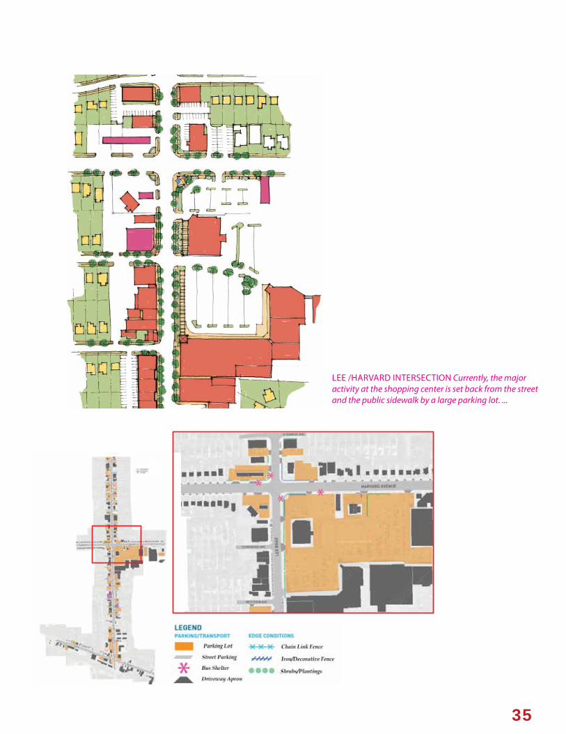
Serving as the anchor retail center in the neighborhood, the Lee-Harvard Plaza provides many amenities for local residents, including Dave’s Supermarket, Walgreens drug store, banking options, various and sundry retail outlets, and the Harvard-Lee Branch Library. Given its central location in the neighborhood, it lacks a coherent street presence,or plaza-like public gesture, and off ers little visibility of the retail stores within the plaza from the major roads.
In order to off er a more public presence, at the corner, and to orient visitors better a variety of urban design treatments may be considered at all four corners of the intersection.
» Street edge: Zoning code standards for commercial buildings, which require a landscaped and/or fenced edge for commercial sites. Stronger enforcement of these zoning requirements will help defi ne the corners better, giving visitors a sense of place.
» Identity/Wayfi nding signage: Signage can orient visitors to surrounding amenities as well as the plaza itself.
» Greening strategy: The parking lot of the Lee-Harvard shopping center is large and under-utulized. Through a simplifi ed circulation pattern, and better pedestrian refuges, a minimum of parking would have to be sacrifi ced. Green islands may also help reduce stormwater runoff tax, due to the large amount of impervious treatment currently on site.
» Material variation: Stamped asphalt, or brick pavers in the crosswalks would enhance the visibility of a pedestrian presence, as well as give a defi ned center to the intersection and plaza, creating it as an identity piece and stopping point in the neighborhood.
» Transit waiting environments: Improvements to major bus stops, including seating in the plaza space at the corner of Lee and Harvard will improve the transit experience.
Identity and wayfi nding signage
h f d d
35
LEE /HARVARD INTERSECTION Currently, the major activity at the shopping center is set back from the street and the public sidewalk by a large parking lot. ...

36
» Pedestrian linkage: Many students from John F. Kennedy High School cut through the parking lot to reach the bus shelter on Lee-Harvard. Providing a safe route for pedestrians reinforces the plaza’s identity as a communal amenity.
JFKHigh School
ShoppingCenter
FireStn.
Potential pedestrian linkage from the High School to the shopping center.
Zoning focused around the Lee Road Corridor. Source: City of Cleveland.

37
Larger trees, various plantings, public art, enhanced transit-waiting environments, identity markers, and various paving materials could all enhance the character of the Lee-Harvard intersection
Reconfi guring the over-sized parking lot at the Lee Harvard shopping center would improve the appearance of shopping center and dramatically improve pedestrian access.

38
LEE ROAD & MILES AVENUE INTERSECTION
Near the major intersection at Lee Road and Miles Avenue there is a variety of business, industrial, and residential uses. Recent development in the area, such as the O’Reilly Auto Parts Store and the CMHA senior housing facility provide a backdrop for some of the vacant sites near the intersection of Lee and Miles. The area is generally characterized by large setbacks, some institutional uses, a small retail strip, a gas station at the northwest corner of Lee and Harvard and a car wash at the southwest corner. There are development sites at the southeast corner of the intersection, as well as east near the corner of E. 167th Street and Miles Avenue There are also historic buildings of architectural signifi cance in the area, particularly along Miles Avenue, traveling east from Lee Road on the south side of Miles.
Development site at the SE corner of Lee Road: Approximately a 39,000SF (.89 acre) parcel, there is currently interest in developing the site as a potential gas station. Zoned as local retail business, small shops could also occupy this site, allowing for a small civic plaza, which would fulfi ll a community need near this end of the neighborhood for small gathering spaces.
Development site near the corner of Miles Avenue and E. 167th Street: Approximately a 109,000SF (2.5 AC) site, zoned for multi-family housing, this site could accommodate townhouses, possibly with an intergenerational component to complement the new CMHA housing to the north.
Utility poles dominate the landscape throughout the corridor, creating potential confl icts with street trees and blocking views to historically signifi cant buildings.

39
TO KERRUISHPARK
TO FREDERICKDOUGLASS PARK
CMHA SENIOR
HOUSING
NEW O’REILLEY’S
AUTO SUPPLY PROPOSED RETAIL/COMMERCIAL
PROPOSED TOWNHOUSES60 DWELLING UNITS
ENHANCEEDGING
PROPOSEDCIVIC PLAZA
1800 SFPEDESTRIAN/RESIDENT ORIENTED RETAIL
PROPOSED WALKING TRAILROUTE
IDENTITYSIGNAGE*
GAS STATION
CARWASH
Infi ll development could help solidify the identity of the neighborhoods create a transitional fabric to the less dense areas of the ward.
SECTION D-D
Inserting identity for the corridor can be accomplished through an aesthetically cohesive wayfi nding system, transit-waiting environments, and landscaping and paving materials.

40
OVERVIEW
Schools are a major asset in Ward 1, providing community outreach programs, after-school programs, health related programming and education, and their recreational facilities. The treatment of these sites, and in particular those sites which contain vacant school buildings, should be commensurate with the will of the community, and maximize benefi t for the community as a whole.
Some of the vacant school sites are being considered as possibilities for a new recreation center, while others have plans for future private development, or are currently active and in need of only minor improvements.
(Former) EMILE B. DESAUZE SCHOOL (140,000 square feet, 3.21 acres): Located fi ve blocks east of Kerruish Park and south of Tarkington Avenue, Desauze school was closed by the CMSD in 2011, as part of a larger school closing and consolidation
strategy. The site is could accommodate higher density housing. The shell of the current building could conceivably be converted for apartments, with new construction of townhouses at the edges of the site, reserving a small amount for green space. Or, the current school building could be demolished, and new construction developed on the site.
CHARLES W. ELIOT SCHOOL This middle school serves close to 800 students in the district. Attached to the site is Frederick Douglass Park (colloquially known as Eliot park, or Miles playfi eld). A new orchard and farmer’s market are proposed for the park, which could position the school and its facilities as a community learning center and place of community engagement, centrally located in the neighborhood. For this reason, the adjacent park is also being considered for a new recreation center.
6. COMMUNITY ASSETS: SCHOOLS
Most schools in the neighborhood are concentrated towards the center of the ward near Harvard Avenue, and Lee Road.

41
New schools serve as anchors for neighborhood development (Adlai Stevenson K-8 School - Bowen Associates, Architects)
WHITNEY YOUNG SCHOOL This is one of the city’s anchor institutions for gifted high school students. In 2010, it was the only Cleveland public school to be recognized with the state’s highest designation of “Excellent with Distinction.” Located less than half of a mile from John F. Kennedy High School, this school serves as a highly reputable community institution.
(Former) ROBERT FULTON ELEMENTARY SCHOOL
(+/-144,000SF 3.31ac): The farthest north of any of the schools in Ward I, this former school building is currently slated for demolition. Closed in 2010, the building sits mid-block between E. 140th and E. 142nd Streets, north of Kinsman Road. The site could be developed as housing, but due to the lack of small pocket parks and playgrounds in the area, it is recommended that the site be developed as a small park space.
(Former) GRACEMOUNT ELEMENTARY SCHOOL
(144,000SF 3.22 AC): This site is being proposed for low density residential development. Located at the end of the block between Glendale Avenue, E. 161st Street and Biltmore Avenue, new development should be designed in a way that is respectful to surrounding housing and the neighborhood context.
ADLAI STEVENSON SCHOOL This PreK-8 school is located in a fairly new building in the northwestern area of the ward. Currently, there are plans for a new park/community garden to be built at the southern edge of the site. Called Joann Park, the design includes a walking path, plantings, a playground, a spray basin, exercise stations, and a new vehicular access point from E. 183rd Street.
ROBERT H. JAMISON SCHOOL The new Jamison Junior High School is located on the southern side of Harvard Avenue between E. 146th and E. 144th Streets. Built to replace the nearby Jamison school at E. 141st and Harvard. The former site is one of the larger school sites in the neighborhood, measuring approximately. 191,000SF, or 4.38ac. While the former school site will no longer be in the 2014 ward boundary, it is still being considered in this plan as a potential site for a community recreation center due to its fairly centralized location, and large site which would allow for both a large indoor recreational facility as well as outdoor programming.
JOHN F. KENNEDY HIGH SCHOOL This school is central to the neighborhood, located along Harvard Avenue, east of Lee Road. Serving as the primary high school for the neighborhood, its enrollment is around 900 students. Its outdoor recreational facilities include a running track and football fi eld. There are no major plans for the site at this time.
RAMAH JUNIOR ACADEMY A private Seventh Day Adventist Christian K-8 school located near the southern border of the neighborhood on Lee Road. Of note at this site is the Johnston Mill Run Trail which will pass by the school and cross over into Kerruish Park. Crosswalk enhancements and signalization may make access/crossing for Ramah students more safe.

42
Desauze School could be redeveloped into housing in the neighborhood , either re-purposing the former school building, and/or using new construction.

43
New construction allows for a more dense housing stock, and alternative forms of development from single family housing.
Incorporation of a small green space on the site would allow a playground, or other small communal gathering space.

44
CHARLES W. ELIOT SCHOOL
WHITNEY YOUNG SCHOOL
Whitney Young High School stands as a neighborhood anchor for some of the area’s brightest students.
A new community garden and orchard will serve to act as community spaces tied to the school.

45
FULTON ELEMENTARY SCHOOL
The former Fulton Elementary School site is the northernmost school site in the ward. The site could be developed in stages to provide green space as a small pocket park, which could be developed in stages as the building awaits demolition.

46
ABELL AVE
E. 1
40TH
ST
E. 1
39TH
ST
E. 1
42N
D S
T
E. 1
43RD
ST
Lawn
New enlarged
playground

47
Low-density residential development at the Gracemount school site per the guidelines of the TAP study.
GRACEMOUNT ELEMENTARY

48
JAMISON SCHOOL
Although just beyond the ward’s boundaries, the former Jamison school site could accommodate a large recreation center.

49
JOHN F. KENNEDY HIGH SCHOOL
RAMAH JUNIOR ACADEMY
Ramah Junior Academy serves as a connection point between Kerruish Park and the proposed Johnston Run MIll Trail.

50
N
0 0.25 mi
Kerruish Park
Adlai Stevenson School
Stevenson Fields
WODA AVE
GLENDALE AVE
GLENDALE AVE
E. 1
77TH
ST
E. 1
86TH
ST
E. 1
88TH
ST
E. 1
89TH
ST
E. 1
90TH
ST
LANBURY AVE
SHAKERWOOD AVE
GLADSTONE AVE
SUNSET DR
KINGS HWY
RIDGEWOOD AVE
E. 1
83RD
ST
E. 1
83RD
ST
WEN
DY
DR
JO A
NN
DR
WEN
DY
DR
JO A
NN
DR
LEE
HEI
GH
TS B
LVD
STRA
ND
HIL
L RD
E. 1
77TH
ST
TALFORD AVE
WALDEN AVE
THROCKLEY AVE
STEVENSON SCHOOL
A new playground is in development for the Stevenson School site.

51
OVERVIEW
Ward I has embedded roots in creating an active,vibrant, and healthy community. Over the past several years, the community has focused on activities and programs that encourage healthy and active living. Initiatives such as HEAL Cleveland and the Ward I Community Health Initiative have led to community gardens, free health screenings, neighborhood playgrounds, healthier food options in local retailers, an annual health fair, and other amenities in the interest of creating a safe, connected, and healthy neighborhood. Goals of the Ward I Community Health Initiative include:
• Supporting healthier lifestyles• Safer neighborhood environments• A more connected neighborhood
This has important design implications including creating and enhancing bike-able, walkable networks, as well as connections to schools, natural amenities, civic spaces, and events.
The neighborhood has many parks, and yet many these green spaces are currently inaccessible or not readily apparent to residents. Even major green spaces such as Kerruish Park and Frederick Douglass Park lack a strong street presence. The Mill Creek and the more natural surroundings to the south of the neighborhood is an under-tapped resource, despite access to it from Kerruish Park. Additionally, there are few pocket parks and small spaces towards the north of the neighborhood. Some of the school sites that are no longer inhabited should be considered for this purpose.
High visibility areas of the neighborhood, such as Lee Road and Harvard Avenue, lack adequate trees and landscaping to facilitate a strong network of active, pedestrian-oriented streets. While diffi cult to compete with heavy traffi c on the major arterials, a greening strategy can help facilitate walkability and additional “eyes on the street.” Street lighting may also help with the perception of some of these corridors and spaces, making them accessible for more hours of the day.
Additionally, vacant parcels, especially those that share adjacency should be considered for use as community gardens, courtyard spaces, and pocket parks throughout the neighborhoods.
7. COMMUNITY ASSETS: PARKS & GREEN SPACES
Image from the Ward I Health Fair & “Stepping out Against Cancer” Walk/Run. Source: Ward I Community Newsletter.

52 52

53
NEW RECREATION CENTER
A new recreation center is a priority for the community. With the desire to minimize the impact on existing parks, the design team studied multiple sites, and narrowed the options to refl ect to the few most viable choices. While the exact architectural program for the building is yet to be determined, a range of 40,000-60,000SF was considered to ensure a proper size for the building footprint. In considering a proper site for the building, a variety of criteria ought to be considered, including: proximity to residents, the size of the overall site, and other green spaces in the surrounding area. The three sites considered as viable options include:
» Kerruish Park: Kerruish Park is the largest public park in the City of Cleveland. The positive aspects of choosing this site are its proximity to a major arterial road meaning easy access for vehicular traffi c, as well as established connections to a network of green spaces--including the proposed Johnston Mill Run Trail, and the Mill Creek. Other recreational facilities, such as baseball diamonds, also exist on this site, making it a comprehensive green site. Currently, a master planning process is on-going for the site. A larger footprint building would also add presence on the street that lacks a strong presence and potentially draw more people to use both the rec center’s facilities as well as Kerruish Park. Enhanced landscaping, better signage, and a network of pedestrian pathways into the park would improve visibility and accessibility to the park from Lee Road. Drawbacks for this site include its location at the southernmost area of the neighborhood, limiting easy access for all in the neighborhood.
» Frederick Douglass Park: The positive aspects of choosing this site include its central location in the neighborhood, proximity to Charles Eliot School, the possibility of including more outdoor facilities, such as a running track and football fi eld, and a “campus” feeling for an under-utilized site. Placing the rec center here could also potentially benefi t the orchards and farmer’s market. Additional playfi elds and enhancements could also be made. Connections to the bike and trail network are also nearby. Drawbacks to choosing this site may mean re-planning the placement of the orchards, and the location is less prominent than the site at Kerruish Park.
» Site of the former Robert Jamison School: Slated for demolition, the site of the former Robert Jamison school at the corner of Harvard Avenue and E. 141st St. While this location is not within the new ward boundaries eff ective January 2014, it is still within close enough proximity to be considered as an option to serve the neighborhood. Positive aspects of selecting this site include the fact that it is embedded in the community, but still located on a main street ( Harvard Avenue). It is also in a fairly central location, though it is somewhat far from the eastern most residents of the neighborhood. The site would also not encroach on any existing public park. Drawbacks for this site include the slightly smaller site, limiting outdoor recreation opportunities here, as well as the time lag and money investment of the demolition of the former school building.

54
(FORMER) JAMISON SCHOOL
DOUGLASS PARK
Siting the building along the edge would establish a relationship between Eliot School, the playfi elds, and the surrounding housing.
Placing the building along Lee Road would create a landmark for visitors to both the park and recreation center.
A smaller footprint for the building may encourage an interior courtyard space for some outdoor activities to take place, while opening views and light penetration for visitors in all directions.
KERRUISH PARK

55
Potential new recreation center at Lee Road edge of Kerruish Park
Enhanced landscaping establishes a strong presence for Kerruish Park along its Lee Road (if a new recreation center is not built in this location).

56
GREEN SPACE NETWORK
Ward 1 is particularly well suited to take advantage of and appreciate its multiple green spaces, community gardens, and parks. Compared with many other parts of the city and surrounding areas, Ward I has a notably large collection of green spaces. There are a few types prevalent throughout the neighborhood:
» School facilities: These largely include outdoor recreational facilities, such as at John F. Kennedy High School, or playgrounds at elementary schools, such as at Stevenson School.
» Multi-use fi elds: These have some recreational components, but are also linked to more passive recreation, such as at Kerruish Park, or to community amenities such as the proposed orchard at Frederick Douglass Park.
» Nature trails: These include the proposed Johnston Mill Run Trail, and connections at the southern end of Kerruish park.
There are numerous opportunities in the neighborhood to highlight more of these assets, such as the area bound by Miles Avenue, E. 175th, Tarkington Avenue, and E. 177th Street.
» Community gardens and small communal spaces: There are numerous community gardens in the ward, and off er a communal as well as health benefi t. Vacant parcels which have been cared for by neighbors may also serve a communal benefi t by acting as small pocket parks or neighborhood greens.
This plan aims is to provide a framework for greater connectivity to the neighborhood’s green and healthy assets. Building on this identity may attract potential residents to the neighborhood, particularly those looking for a variety of outdoor spaces for activity, communal benefi ts, and multi-generational amenities.
Potential wayfi nding and identity signage, highlighting particular amenities of the neighborhood, such as its shopping amenities, green network and healthy living activities.

57
A potential network of existing and proposed green
spaces.

58
GREEN CONNECTIONS
Given the multiple green and recreational nodes in the neighborhood, a network of these connected spaces would amount to a cohesive neighborhood scale “Emerald necklace” of sorts, which the community could leverage in its connectivity to other parts of the neighborhood, the rest of Cleveland, Maple Heights, and Garfi eld Heights. This neighborhood network could feed into larger green space systems by connecting to the Towpath Trail, Shaker Lakes, and the Garfi eld Reservation.
To build this network, a variety of steps would need to be taken to complete these circuits. An existing bicycle infrastructure network, such as the bicycle lanes on Harvard Avenue, and the multiple bike-friendly routes throughout the neighborhood aids in achieving this goal.
One of the largest obstacles in creating a green space network is a lack of perception of some of these spaces as accessible, or as linked to one another. The two images at right show how the Shaker Lakes network is somewhat comparable in size to the green space amenities of the Ward I neighborhood. While the connection at Shaker Lakes is somewhat more explicit, the amenities in Ward I are nevertheless a cohesive network, serving a wide variety of residents in the neighborhood.
In order to better connect these spaces, prioritization of the types of amenities they off er (such as those listed above), may help with the selection of how these connections are made. For example, prioritizing bike lanes on Lee Road would provide a large benefi t in getting residents to other regional destinations, whereas prioritizing a multi-generational loop around the CMHA senior housing complex or around Desauze School, or Frederick Douglass Park would provide a diff erent result. Likewise, connections for recreational cyclists or pedestrians is diff erent than for commuters or those without automotive transportation. Anchors such as a new recreational facility, or schools should also be considered when linking multiple points.
The framework provided here should provide the community with discussion points for engaging local residents as well as Maple Heights and Garfi eld Heights for an interconnected network beyond city boundaries.
Proposed improvements to certain green spaces and networks are already in the works and are briefl y outlined here:
» Joann Park: Proposed at the Southern edge of Aldai Stevenson School.
» Fulton Playground: Located at the site of the former Fulton School, this space is intended to be a playground.
» Jamison Gardens: Located at the southern edge of the new Robert Jamison School
» Douglass Orchards: Proposed orchards would serve as both a place for growing as well as a site for a farmer’s market.
» Kerruish Park: This plan would better link the northern and southern half of the parks across Tarkington Avenue and would connect to the Johnston Mill run Trail.
» The Johnston Mill Run Trail: Proposed alignment shown above would connect through Garfi eld Heights, connecting to Arthur Johnston Park in the Miles Island area of the neighborhood. It would also connect to Kerruish park, crossing Lee Road by the Ramah Junior Academy. It is recommended that pedestrian crossings be enhanced at this crossing, either through signage and markings, or a combination of signage, markings, and lighting.
» E. 173rd Bike Boulevard: This project would serve as an alternate route for cyclists trying to head north/south between Harvard Avenue, and north into Shaker Heights. The proposed plan would break through concrete barriers currently separating the two municipalities, allowing for a variety of connection options.
In addition, there are existing bike connector routes, as identifi ed by the city, and shown in the diagram on the following pages The goal of a legible green network should be to connect a variety of green type spaces and institutions such as schools and the proposed new recreation center, as well as provide safe options for multiple forms of transportation.

59
Image showing proposed Johnston Mill Run Trail and surrounding green spaces. Source: Environmental Design Group
The Shaker Lakes green network provides ecological as well as recreational and learning opportunities.
Phase 1 trail routeExisting off -road trailPotential alternate routesAlternate connection toKerruish park
A large collection of green spaces with a variety of functions exists in the ward, and could benefi t from wayfi nding and connective strategies.
60
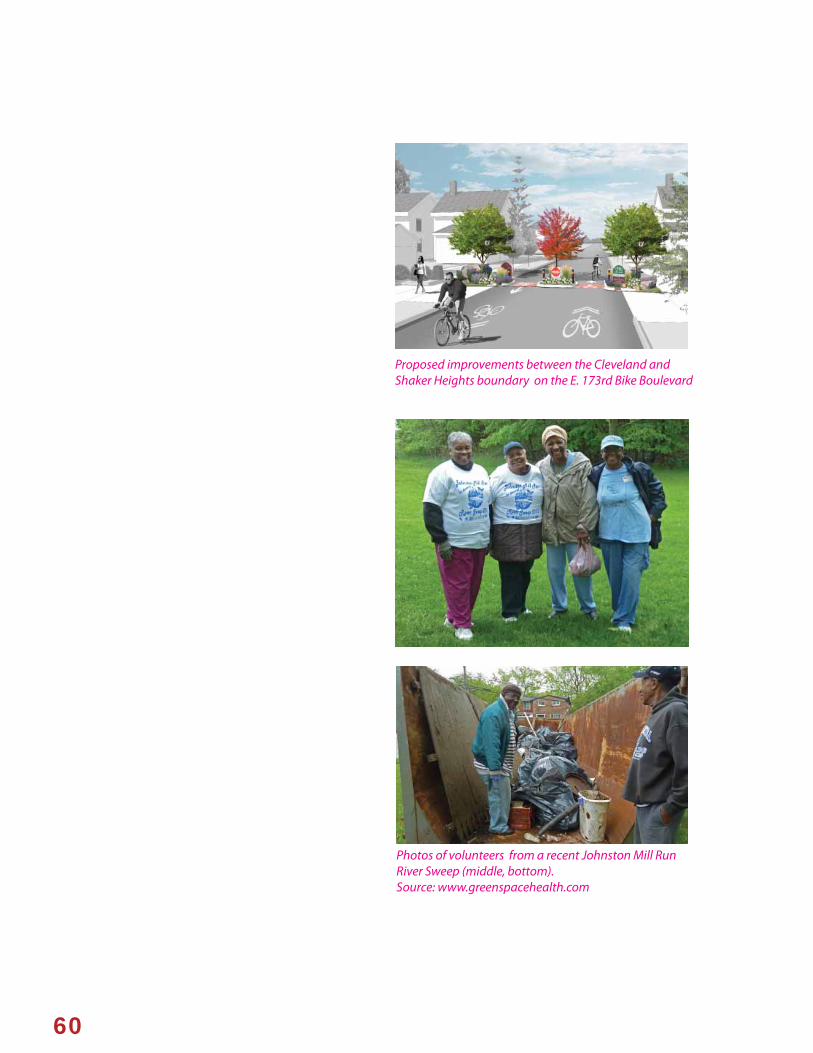
Photos of volunteers from a recent Johnston Mill Run River Sweep (middle, bottom). Source: www.greenspacehealth.com
Proposed improvements between the Cleveland and Shaker Heights boundary on the E. 173rd Bike Boulevard

61
LEE RD
.LEE R
D.
MILES AVE.
HARVARD AVE. HARVARD AVE.
VACANT LOT

62
Proposed Green Loop with core circular routes, connections to schools, and spokes to other regional destinations.
LEE RD
.LEE R
D.
HARVARD AVE.
MILES AVE.
HARVARD AVE.

63
GREEN LOOP CONNECTIONS

64
These vacant parcels, currently in the land bank could potentially off er ecological as well as communal benefi ts as a connective piece between (former) Desauze School, Kerruish Park, Miles Avenue and the surrounding neighborhood.
Creating bioretention swales and a riparian strategy reduces the amount of stormwater runoff and can act as a feature along paths. A variety of benefi ts can be obtained through a bioretention swale, such as reducing runoff and breaking down pollutants through carefully chosen planting and design strategies.

65
Multiple types of green spaces and connections would allow for a multitude of benefi ts, including ecological, recreational, and connectivity across the city.

66
MILES ISLAND VACANCY & BEAUTIFICATION STRATEGY
While the eff ects and scale of vacant parcels throughout the ward are not as detrimental as many other areas of the city, a large concentration can be found in the south-western most part of the neighborhood situated south of Miles Avenue and north of I-480, called “Miles Island.” Here, concentrations of single family residential units are broken up by larger industrial sites, centered around the Johnston Parkway spine.
An incomplete street grid creates multiple dead end streets in the neighborhood, reducing access to other parts of Ward 1, but creating a sense of peaceful seclusion. The rail line running just south of Miles Avenue increases this sense of seclusion. As a result, the neighborhood has a quiet character, away from the heavy traffi c around Lee Road or Harvard Avenue. Well-maintained vacant lots (such as those pictured right) give the neighborhood a pleasant feel.
The proposed Johnston Mill Run Trail entering at the northern end of E. 147th St. would increase the amenities in this particular area, as it would increase the ability to connect to surrounding areas by bicycle or walking. Given this area’s low density and the numerous vacant parcels, infi ll housing construction in this area should be considered in the context of keeping some vacant lots as community amenities, either as neighborhood playgrounds, community gardens, or development around a shared courtyard typology. Lot splitting, where the city deeds half of a vacant parcel to owners on either side of a lot may also build amenities for private homeowners, as well as increase the local tax base for the land, as opposed to simply holding a parcel in the land bank. Market interests for housing in this area may be based around easy access to the highway, multiple green amenities, a quiet atmosphere, and lower taxes than surrounding municipalities.
While many parcels in the Island are well cared for, some vacant sites have become under-maintained.
The Miles Island Community Garden occupies a formerly vacant parcel at E. 158th St.
New construction should be encouraged to increase density in strategic places; in other areas, vacant lots should be maintained as a communal asset.

67

68
FROM PLAN TO ACTION
(SECTION TO BE COMPLETED BASED ON INPUT FROM STEERING COMMITTEE MEETING 3 & COMMUNITY MEETING 3)
This plan is intended to serve as a road map for future development, investment, and improvements. The community identifi ed the following priorities for implementations:
PHYSICAL CHARACTER and NEIGHBORHOOD APPEARANCE:
Streetscape improvements
Lee Road overhead utilities
Lee Harvard Shopping Plaza:
HEALTHY and ACTIVE LIVING
New Recreation Center:
Bike and pedestrian improvements:
Green space network:
Johnston Mill Trail:
DEVELOPMENT OPPORTUNITIES
School sites:
Lee Road & Miles intersection:
8. COMMUNITY PRIORITIES FOR IMPLEMENTATION