waquoit bay national estuarine research reserve management ... · waquoit bay national estuarine...
TRANSCRIPT
Waquoit Bay National Estuarine Research Reserve Management Plan
2014-2019
Supporting Coastal Communities through Science
December, 2013 This Management Plan has been developed in accordance with NOAA regulations, including all provisions for public involvement. It is consistent with the congressional intent of Section 315 of the Coastal Zone Management Act of 1972, as amended, and the provisions of the Massachusetts Coastal Zone Management, October 17, 2005.

Acknowledgements This Management Plan was produced by current and former staff members of the Waquoit Bay National Estuarine Research Reserve:
• Nancy Church, School and Interpretive Program Coordinator • Mary-Kay Fox, Former Assistant Research Coordinator • Alison Leschen, Former Reserve Manager • Jordan Mora, GIS/Research Technician • Joan Muller, Education Coordinator • Sheri Proft, Fiscal Administrative Assistant • James Rassman, Stewardship Coordinator\Acting Manager • John Singleton, Forest and Parks Supervisor • Tonna-Marie Surgeon-Rogers, Coastal Training Program Coordinator • Laurie Tompkins, Volunteer and Events Coordinator • Christopher Weidman, Research Coordinator
The ad-hoc Reserve Advisory Committee met to help focus the Reserve’s priorities for the next five years. The committee included representatives from MA Department of Conservation and Recreation, MA Coastal Zone Management, Wood Hole Sea Grant, NOAA, Narragansett Bay NERR, NERRS Science Collaborative, Cape Cod Commission (the local Regional Planning Agency), Buzzards Bay National Estuary Program, the Mashpee Wampanoag Tribe, and several local environmental non-profits and community organizations. In addition, a Market Analysis/Needs Assessment for K-12 Education, and a CTP Needs Assessment were completed in 2011-12. Results of those studies have been incorporated into Goals and Objectives of this plan. Public Comment Period: July 1- 31, 2014. Please direct all comments to [email protected].
Table of Contents: Volume I EXECUTIVE SUMMARY .......................................................................................................................... 1
OVERVIEW.................................................................................................................................................. 1 ACCOMPLISHMENTS ..................................................................................................................................11 PLAN HIGHLIGHTS .....................................................................................................................................13
CHAPTER 1: INTRODUCTION ..............................................................................................................15 PURPOSE AND SCOPE OF PLAN...................................................................................................................15
Public Process for Developing the Plan ..............................................................................................16 RESERVE MANAGEMENT STRUCTURE .......................................................................................................17
Introduction to the National Estuarine Research Reserve System .......................................................17 Massachusetts Department of Conservation and Recreation ..............................................................21
HISTORY OF WAQUOIT BAY RESERVE .......................................................................................................22 Boundaries ...........................................................................................................................................23 Boundary Change ................................................................................................................................24 Description of properties and assets ....................................................................................................29
ASSETS OF WAQUOIT BAY NATIONAL ESTUARINE RESEARCH RESERVE ..................................................32 Natural Resources ................................................................................................................................32 Archeological, Historical, and Cultural Resources .............................................................................34
CHAPTER 2: UNDERSTANDING COASTAL ECOSYSTEMS ...........................................................36 OVERVIEW.................................................................................................................................................36 RESEARCH AND MONITORING PLAN [§921.50] .........................................................................................38
NERRS Science Collaborative .............................................................................................................38 System-Wide Monitoring Program ......................................................................................................39 Monitoring at WBNERR ......................................................................................................................40 Waquoit Bay Reserve Research and Monitoring Objectives ................................................................43
CHAPTER 3: FROM KNOWLEDGE TO ACTION: IMPROVING ENVIRONMENTAL LITERACY AND FOSTERING MANAGEMENT SOLUTIONS .........................................................53
OVERVIEW.................................................................................................................................................53 RESERVE SYSTEM EDUCATION PLAN [§921.13(A)(4)] ..............................................................................55 THE WAQUOIT BAY RESERVE EDUCATION PROGRAM ..............................................................................55
Teacher Training and K-12..................................................................................................................55 Education Program Objectives ............................................................................................................58 Community Education ..........................................................................................................................61
RESERVE SYSTEM COASTAL TRAINING PROGRAM ....................................................................................66 THE WAQUOIT BAY RESERVE COASTAL TRAINING PROGRAM ..................................................................66
Coastal Training Program Objectives .................................................................................................69 Identifying and Planning Outreach to Target Audiences .....................................................................75 Leveraging Training and Education Activities ....................................................................................76 Other Community Engagement ............................................................................................................77
CHAPTER 4: PRACTICING WHAT WE PREACH: LAND AND FACILITIES MANAGEMENT 79 OVERVIEW.................................................................................................................................................79 LAND MANAGEMENT ................................................................................................................................79
Waquoit Bay Reserve’s Land Management Objectives ........................................................................79 Protected Species Management ...........................................................................................................82
ECOLOGICAL RESTORATION ACTIVITIES ...................................................................................................84 LAND ACQUISITION ...................................................................................................................................85 FACILITIES, GROUNDS AND EQUIPMENT ....................................................................................................88
Sustainability .......................................................................................................................................88

CHAPTER 5: IMPROVING OPERATIONS AND STATURE..............................................................92 MANAGEMENT OBJECTIVES ......................................................................................................................92
Self-Evaluation .....................................................................................................................................92 Agency Partners ...................................................................................................................................95 Management Agreements .....................................................................................................................98 Advisory Groups ................................................................................................................................100
STAFFING ................................................................................................................................................101 Reserve Staff Roles and Responsibilities ............................................................................................101 Future Staffing Plan ...........................................................................................................................106 Staff Training and Emergency Response ...........................................................................................107 Volunteers ..........................................................................................................................................108
BIBLIOGRAPHY .....................................................................................................................................115
VOLUME II: APPENDICES ...................................................................................................................... 1 Overview ............................................................................................................................................... 2 Landscape Designations ....................................................................................................................... 2 Land Use overlays................................................................................................................................. 2 Enforcement .........................................................................................................................................40
List of Figures FIGURE 1: SUMMARY OF WBNERR GOALS, OBJECTIVES AND KEY ACTIVITIES. ........................................... 4 FIGURE 2: NATIONAL ESTUARINE RESEARCH RESERVE SYSTEM. ..................................................................19 FIGURE 3: DCR DIVISION OF STATE PARKS AND RECREATION ORGANIZATIONAL CHART (RELEVANT TO
WBNERR). ..........................................................................................................................................22 FIGURE 4: WBNERR PROPERTIES. ................................................................................................................25 FIGURE 5: LAND USE CHANGE IN THE WAQUOIT BAY WATERSHED. .............................................................27 FIGURE 6: PROPERTY BOUNDARY, RESERVE CORE AND BUFFER AREAS .......................................................28 FIGURE 7: SUMMARY OF STATEMENTS GUIDING WBNERR AND NERRS RESEARCH AND MONITORING. ....37 FIGURE 8: WAQUOIT BAY NERR MONITORING SITES. ..................................................................................41 FIGURE 9: WAQUOIT BAY TRAINING AND EDUCATION MISSION STATEMENTS ..............................................54 FIGURE 10: PROTECTED AREAS IN THE WAQUOIT BAY WATERSHED .............................................................87 FIGURE 11: RESERVE BUILDING ENERGY USAGE OVER TIME ..........................................................................89 FIGURE 12: 312 EVALUATION METRICS ..........................................................................................................94 FIGURE 13: WAQUOIT BAY NERR ORGANIZATIONAL CHART WITH POSITION FUNDING SOURCE (JUNE 2012).
...........................................................................................................................................................101 FIGURE 14: HEADQUARTERS AND CHILDS RIVER AREAS. ............................................................................... 4 FIGURE 15: SOUTH CAPE BEACH AREA. .......................................................................................................... 5 FIGURE 16: WASHBURN ISLAND AREA. ........................................................................................................... 6 FIGURE 17: QUASHNET RIVER AREA (INCLUDING THE SATELLITE “PHINNEY PROPERTY”). ............................ 7 FIGURE 18: ABIGAIL BROOK AREA. ................................................................................................................ 8 FIGURE 19: NORTH QUASHNET WOODS AREA. ............................................................................................... 9 FIGURE 20: CALEB POND (NEW PARCEL). .......................................................................................................10 FIGURE 21: ACEC AND WBNERR BOUNDARIES. .........................................................................................18 FIGURE 22: LAND USE CHANGE IN THE WAQUOIT BAY WATERSHED ...........................................................46 FIGURE 23: RARE SPECIES HABITAT ..............................................................................................................47 FIGURE 24: WAQUOIT NATIONAL HISTORIC DISTRICT ...................................................................................47

Volume II: Appendices APPENDIX A ................... DCR’S LANDSCAPE DESIGNATIONS AND STEWARDSHIP ZONING ...................................................................................................................................................................... A2 APPENDIX B 2007 312 EVALUATION FINDINGS ........................................................................ A11
APPENDIX C SUMMARY OF PUBLIC REVIEW PROCESS .................................................. A13
APPENDIX D FEDERAL CONSISTENCY CERTIFICATION – ............................................. A16
APPENDIX E WAQUOIT BAY AREA OF ENVIRONMENTAL CONCERN (ACEC) .............. A17
APPENDIX F LAWS AND REGULATIONS .................................................................................... A26
APPENDIX G NON-SWMP MONITORING PROGRAMS........................................................ A31 APPENDIX H KEEP IMPLEMENTATION PLAN ..................................................................... A34
APPENDIX I WAQUOIT BAY RESERVE PUBLIC ACCESS PLAN .......................................... A39
APPENDIX J WBNERR LAND ACQUISITION PLAN: 2014-2019 .............................................. A41
APPENDIX K MOU BETWEEN NOAA AND MASSACHUSETTS DEPARTMENT OF CONSERVATION AND RECREATION .............................................................................................. A54 APPENDIX L MOU BETWEEN THE TOWN OF MASHPEE AND THE COMMONWEALTH OF MASSACHUSETTS REGARDING SOUTH CAPE BEACH ....................................................... A59
APPENDIX M MOU CONCERNING COOPERATION AND COORDINATION WITH REGARD TO THE MASHPEE NATIONAL WILDLIFE REFUGE ................................................. A65
APPENDIX N MOU BETWEEN DEM AND DFW (QUASHNET RIVER MANAGEMENT) A70 APPENDIX O MOU BETWEEN DCR AND WAQUOIT BAY RESERVE FOUNDATION ....... A72
APPENDIX P INTERDEPARTMENTAL SERVICE AGREEMENT BETWEEN EXECUTIVE OFFICE OF ENVIRONMENTAL AFFAIRS (DCR) AND THE UNIVERSITY OF MASSACHUSETTS, DARTMOUTH .................................................................................................... A79
List of Acronyms
CBSM Community-based Social Marketing CDMO Centralized Data Management Office CDM Coastal Decision-Makers COOPS Center for Operational Oceanographic Products and Services CTP Coastal Training Program CZM Coastal Zone Management DCR Department of Conservation and Recreation DEM Department of Environmental Management DEP Department of Environmental Protection DMF Division of Marine Fisheries DON Dissolved Organic Nitrogen DSPR Division of State Parks and Recreation EEOS Environmental, Earth and Ocean Sciences Department (at U-Mass Boston) GIS Geographic Information Systems GPS Global Positioning System IOOS Integrated Ocean Observing System MA Massachusetts MAL Macroalgae MBL Marine Biological Laboratory MEPA Massachusetts Environmental Policy Act MCZM Massachusetts Coastal Zone Management MNWR Mashpee National Wildlife Refuge MOU Memorandum of Understanding NBDS National Buoy Data Center NEP National Estuary Program NERRS National Estuarine Research Reserve System NHESP Natural Heritage and Endangered Species Program (Massachusetts) NO2 Nitrite NO3 Nitrate NH3 Ammonia NH4 Ammonium NOAA National Oceanic and Atmospheric Administration PAR Photosynthetically Active Radiation PO4 Orthophosphate RSP Restoration Science Program SAV Submerged Aquatic Vegetation SWMP System-wide Monitoring Program UMASS University of Massachusetts URI University of Rhode Island USGS United States Geological Survey WBNERR Waquoit Bay National Estuarine Research Reserve WHOI Woods Hole Oceanographic Institution

Executive Summary
Overview Waquoit Bay National Estuarine Research Reserve Management Plan 2014-2019 is the fourth Management Plan for the Waquoit Bay National Estuarine Research Reserve (WBNERR). It describes the history, assets, programs, and administrative structures of WBNERR. It also defines and lays out the strategy for meeting the Reserve's mission over the next five years. The plan provides an update to the Waquoit Bay National Estuarine Research Reserve Management Plan, August 2006 and includes a boundary update resulting from land acquisitions. The Reserve’s mission and vision are defined below.
Mission: To promote science-based decision-making that leads to healthy coastal ecosystems. Vision: To be a vital regional resource for expertise on sustainable coastal management.
The Reserve’s goals are to:
1. Improve the understanding of coastal ecosystems and the human influences on them.
2. Improve environmental literacy in our communities to enable environmentally-sustainable decision-making.
3. Foster coastal ecosystem management solutions through sustained community
engagement.
4. Manage land and facilities in a manner that balances enjoyment by current generations with conservation for future generations.
5. Improve the operations and stature of the Reserve.
1

Figure 1 depicts the goals and provides a summary of related objectives and key activities. These elements are described in detail in their respective chapters. The Waquoit Bay National Estuarine Research Reserve supports coastal communities through science. It is a center of excellence with regard to estuarine science - science that is conducted by in-house researchers, in collaboration with scientists from world-renowned laboratories, and by independent researchers who are attracted by the infrastructure and information that the Reserve provides to support and guide their work. Currently, the Reserve’s Priority Areas are:
• Impact of climate on estuarine ecosystems. • Connection between watershed land use and water quality/eutrophication • Assessment of ecosystem response to natural variability and human impacts • Understanding and enhancing ecosystem services of coastal habitats
Reserve staff draws upon the scientific work conducted at WBNERR and elsewhere to promote better and more informed coastal management. The Reserve’s Training and Education programs specifically guide individuals in their professional and personal roles toward environmentally-sustainable decisions. The Training and Education programs include the Coastal Training, Teacher Training, K-12 and Community Education programs. WBNERR’s Stewardship Program employs adaptive management techniques to protect the land and water resources of the Waquoit Bay watershed. Natural resource management on the Reserve is guided by the results of research conducted at the Reserve and elsewhere and is shared throughout the region through education and training. Furthermore, the Reserve serves as a model of resource management practices for similar coastal lands in the region. The Waquoit Bay NERR is one of 28 sites that comprise the National Estuarine Research Reserve System (NERRS), a federal-state partnership of protected research and education sites administered by the National Oceanic and Atmospheric Administration (NOAA) and state partners. In this case, the state partner is the Massachusetts Department of Conservation and Recreation (DCR). The National Estuarine Research Reserve System was created by the Coastal Zone Management Act (CZMA) of 1972, as amended, 16 U.S.C. Section 1461, to augment the Federal Coastal Zone Management (CZM) Program. Reserves are required by Federal regulation, 15 C.F.R. Part 921.13, to have a NOAA-approved Management Plan that is updated every five years. The plans must describe Reserve goals and objectives, management issues, and strategies for addressing them. NOAA’s stated purposes for Management Plans are to:
• Provide a vision and framework to guide Reserve activities during the next five years.
• Enable the Reserves and NOAA to track progress and realize opportunities for growth.
2

• Present Reserve goals, objectives, and strategies for meeting the goals to constituents.
• Guide program evaluation under Section 312 of the CZMA. • Enable the Reserves to acquire facilities construction and land acquisition funds.
In addition, the Reserve’s state partner, DCR, pursuant to M.G.L. Chapter 21, Section 2F, is required to prepare management plans for all reservations, forests, and parks under the management of the Department. These plans must include guidelines for operations and land stewardship, shall provide for the protection of natural and cultural resources, and ensure consistency between recreation, resource protection, and sustainable forest management. The Commissioner shall seek and consider public input in the development of resource management plans, and shall make draft plans available for a public review and comment period thought notice in the Massachusetts Environmental Monitor. Resource Management Plans must be submitted to the DCR Stewardship Council for the Council’s adoption. DCR’s resource management planning process includes the use of Stewardship Zoning Guidelines as a framework for the management of land and resources. The guidelines are incorporated into this Management Plan. DCR planning staff are currently writing the Resource Management Plan for the Waquoit Bay Reserve (part of the Cape Cod Complex), with a 2014 expected completion date.
3

Figure 1: Summary of WBNERR Goals, Objectives and Key Activities. These figures are designed to provide a quick overview of the Reserve’s goals and how they are carried out. Further details of the research and monitoring projects, education and training programs, and land and facilities management are provided in the chapters that follow. Goal 1 involves the Reserve’s Research and Monitoring programs. See Chapter 2 for further detail
4
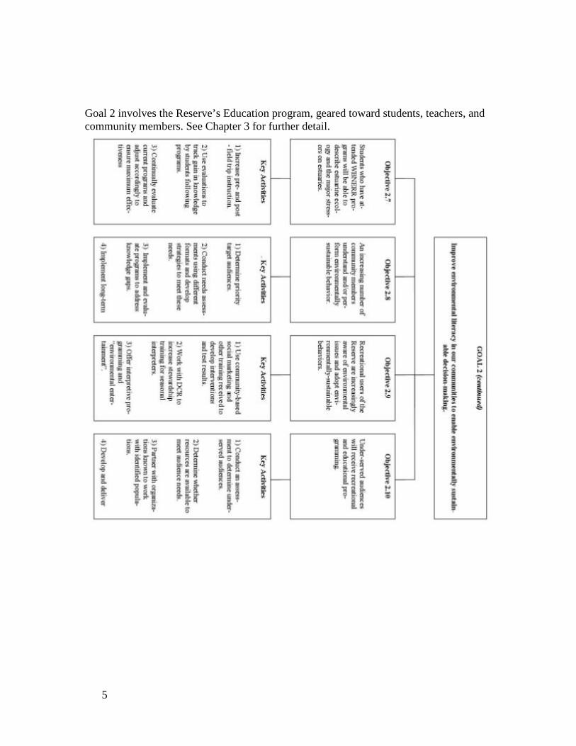
Goal 2 involves the Reserve’s Education program, geared toward students, teachers, and community members. See Chapter 3 for further detail.
5
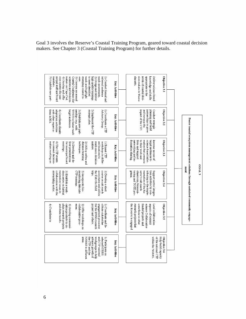
Goal 3 involves the Reserve’s Coastal Training Program, geared toward coastal decision makers. See Chapter 3 (Coastal Training Program) for further details.
6

7

Goal 4 involves land and facilities management. See Chapter 4 for more details.
8

Goal 5 involves improving the operations and stature of the Reserve. See Chapter 5 for more details.
9

10

Accomplishments There have been significant accomplishments during the past five years toward addressing goals in the 2006 Management Plan. These include: Goal 1: Improve the understanding of coastal ecosystems and the human influences on them:
o Installation of an Estuarine Groundwater Observatory in 2007 (10 monitored wells) including the creation and maintenance of a continuous groundwater monitoring program, and robust use of the facility by visiting scientists for estuarine groundwater research.
o Completed several initial phases of the Reserve’s Sentinel Site – called the Salt Marsh Observatory, which includes: 1) the SWMP emergent wetlands biomonitoring component, 2) NGS-approved elevation control network of permanent benchmarks and Sediment Elevation Tables, and
o Completed second aerial survey of the Reserve’s emergent marsh vegetation (SWMP Mapping Component).
o Completed our 2nd and 3rd Macroalgal Biomass (and bottom sediment) Surveys (2007, 2011) of the Waquoit Bay estuarine system (SWMP Biotic Component) initially developed in 2004.
o Established (2006) a weekly citizen water quality monitoring program of 15 major tidal ponds in the Town of Falmouth – Falmouth Pondwatchers- in partnership with a local civic organization (Falmouth Associations Concerned with Estuaries and Salt Ponds - FACES) and newspaper (Falmouth Enterprise).
o Receipt and completion of first year objectives of a large and comprehensive NERRS Science Collaborative grant with multiple partners to study greenhouse gas exchange in salt marshes and the effect of nitrogen on those processes.
o Completion of the Reserve’s Habitat Mapping and Change Plan. Goal 2: Improve environmental literacy in our communities to enable environmentally-sustainable decision-making:
o KEEP/TOTE: With funding from a NOAA B-WET grant, Waquoit Bay Reserve worked together with Wells and Narragansett Bay NERRS to launch TOTE, Teachers on the Estuary, a multi-day intensive teacher training program which links teachers with Reserve research, field-based activities and on-line NOAA data analysis tools.
o Completion of a market analysis of environmental education organizations providing programs on Cape Cod.
o Establishment of a KEEP K-12 Estuarine Education Program (Teacher) Advisory Committee.
o Completion of a needs assessment of K-12 teachers who teach science on Cape Cod and creation of a KEEP Action Plan based on the Needs Assessment created by Reserve education staff with input from the Teacher Advisory Committee.
11

o Completion of a cultural needs assessment of recent immigrants to Cape Cod and offering of an Environmental Leadership Course and other programs to this underserved audience.
o Completion of an updated CTP Strategic Framework. o Completion of a formal CTP Needs Assessment of regional and municipal
decision-makers. o Revamping CTP Advisory Group and making the original Advisory and
Steering Committee functions more efficient and practical. o Growth and recognition of the CTP in southeastern Massachusetts.
Establishment of new partnerships for the CTP. o Increased linkages for the CTP with scientists working in our region. o Involvement of the CTP in two NERRS Science Collaborative proposals. o Hiring of a part-time CTP Assistant to support collaboration activities
under the Science Collaborative grant awarded to WBNERR. Goal 3: Demonstrate sustainable stewardship of the land and water ecosystems within in the reserve to serve as a model for community stewardship in the region.
o Purchase of Caleb Pond parcel and Quashnet River addition o Completion of a Waquoit Bay Stream Restoration Master Plan, aimed at
prioritizing and guiding future restoration projects. o Reintroduction of prescribed fire to manage rare grasslands.
Goal 4: Foster dialogue and development of coastal ecosystem management solutions through sustained community engagement:
o Increased community outreach to bring the Reserve’s work and message to different audiences through the WBNERR Science Forum held at Woods Hole Oceanographic Institution, the Research @ the Reserve series for the public, and talks for community groups.
o see Goal 2 – CTP accomplishments for overlap with this Goal. Goal 5: Improve the operations, infrastructure and stature of the Reserve:
o Completion of a Facilities Vision Plan, intended to guide Headquarters facilities development into the future.
o As the first step in carrying out the facilities plan, receipt of 315 Construction funds to build a new maintenance building, make significant campus improvements, install photovoltaic panels and other energy improvement measures, update educational exhibits, and build a research dock.
o Significant improvements to visitor enjoyment of Reserve properties, such as viewing platforms on marsh trails, and a handicapped accessible boardwalk to South Cape Beach.
o Significant energy efficiency measures, resulting in reduction in total BTUs per heating degree day of over 36% since 2002. Conducted Greenhouse Gas Analysis of Reserve operations and lands.
o Purchase of a new truck and 4 new boat motors and trailers.
12
Integrated Projects: 1. Science Collaborative (p. 42) 2. Salt Marsh Observatory – sentinel site (see p. 46) 3. Teachers on the Estuary (TOTE) (p. 63) 4. Interpretive Plan (p. 67) 5. Salt Marsh Classroom (p. 75) 6. South Cape Beach Management Strategies (p. 85) 7. Green Team (p. 93)
o Development of an Emergency Management Plan and Hurricane Response Plan. Implemented latter in summer 2010 in response to Hurricane Earl in summer 2011 for Hurricane Irene, and 2012 for Hurricane Sandy.
o Re-establishment of a Reserve Advisory Committee o Establishment of a new Friends Group, the Waquoit Bay Reserve
Foundation, which has taken over management of the sub-award from Citizens for the Protection of Waquoit Bay, and will hopefully provide a significant fundraising role.
o Evolution of the half-time Technology Coordinator position into a full-time GIS/Research technician position (half-funded under the NOAA Operations grant, half by external sources).
o Re-structuring of duties of Event, Volunteer, and Education staff to now include a full time Event and Volunteer Coordinator, and a full-time School and Interpretive Program Specialist position.
Plan Highlights The objectives in this plan represent a maturation of many of the Reserve’s ongoing programs and the introduction of a few new initiatives. Some of the highlights are listed below. New and recent activities documented with this plan:
• With this Management Plan, new properties purchased over the past five years are being formally added to the Waquoit Bay NERR. These parcels include the Caleb’s Pond parcel which was the largest undeveloped parcel on Waquoit Bay, and the addition of three parcels that protect the critical eastern brook trout fishery at the Reserve’s Quashnet River Component.
• Projects that intentionally integrate all the sectors. These projects will be highlighted and described in more detail throughout the document, appearing in grey “call-out” boxes. These are projects where all sectors will work together to define the issues, identify and fill data gaps or gather information, make decisions about content or products, and deliver results to pertinent audiences.
13

• Greater emphasis on raising awareness of the Reserve and what we do, within a wide variety of audiences through website, social media, interpretive programs and products, talks to community groups, etc.
• Coupling technical training with technical assistance to communities to support implementation of decisions and management actions that align with sustainable coastal management.
• Using collaborative partnerships and a collaborative learning approach model where possible in training workshops and research projects to affect better coastal management.
• Incorporating best practices and lessons learned from the Reserve’s resource management and restoration practices into training programs.
• Continued and increased coordination with partners, in particular, other coastal management organizations.
New initiatives to be pursued during the term of this Management Plan:
• Evaluation of current monitoring programs. • Concerted effort to make datasets from our research and monitoring programs
available through our website or other means. • Greater focus on analyzing existing data sets and translating results for our
various audiences (volunteers, teachers, students, coastal decision-makers, researchers and the public).
• Addition of Reserve-wide 312 Evaluation Performance metrics to be collected and evaluated under this plan.
• Development of a comprehensive interpretive plan that will standardize, integrate, and guide content and look of interpretive signage and displays on all Reserve properties. More emphasis on non-personal interpretation- exhibitory and outdoor interpretive signage for the first few years of this Management Plan.
• Major emphasis on 20-year maintenance of buildings. • Training of pre-service teachers. • Increased emphasis on utilizing different approaches to effectively reach more
coastal decision-makers. • Development of new strategic partnerships to continue to meet coastal decision-
maker information needs and address barriers to receiving and applying scientific information.
• An increased number of trainings of varying commitments of time to attract a diversity of teachers to our training programs while maintaining the in-depth training of the TOTE program.
While these projects are deliberately designed to integrate the sectors, we are emphasizing this approach in all areas where feasible. Thus while much of this Management Plan focuses on the work of each sector, we recognize that the whole is far greater than the sum of its parts, and that our objectives can almost always be better met by working together.
14

Chapter 1: Introduction Purpose and Scope of Plan Waquoit Bay National Estuarine Research Reserve Management Plan 2012-2017 is the fourth Management Plan for the Waquoit Bay National Estuarine Research Reserve (WBNERR). It describes the history, assets, programs, and administrative structures of WBNERR. It also defines and lays out the strategy for meeting the Reserve's mission, vision and goals over the next five years.
The Reserve’s mission and vision are defined below.
Mission: To promote science-based decision-making that leads to healthy coastal ecosystems. Vision: To be a vital regional resource for expertise on sustainable coastal management.
The Reserve’s goals are to:
1. Improve the understanding of coastal ecosystems and the human influences on them.
2. Improve environmental literacy in our communities to enable environmentally-sustainable decision-making.
3. Foster coastal ecosystem management solutions through sustained community
engagement.
4. Manage land and facilities in a manner that balances enjoyment by current generations with conservation for the future.
5. Improve the operations and stature of the Reserve.
15

The Management Plan is organized by goals rather than strictly by program area. This being said, the goals primarily address the Reserve's program areas of research and monitoring (Goal 1), education and training (Goals 2 and 3), and stewardship (Goal 4), respectively. The interconnectedness of the program areas is most especially demonstrated in Chapter 5 which addresses Goal 5, in the Integrated Projects highlighted throughout this document, and in the objectives and action items that are listed within each chapter. All of the programs address the Reserve’s Priority Areas. In addition to goals and theme areas, the Reserve is guided by a series of principles. These overarching guiding principles describe how the Reserve conducts business. They are:
• WBNERR staff from all program and administrative areas collaborates to advance the Reserve's goals and objectives.
• Reserve activities and programs are targeted to lead to real behavioral change in support of better coastal stewardship.
• The Reserve guides people toward environmental literacy by presenting information systematically and strategically, and by providing opportunities for people to become engaged in problem solving on environmental issues. The Reserve works in partnership with others at the local, state, regional and federal level.
• Reserve programs capitalize on the physical setting of the Reserve to inspire questions, learning, and informed decision-making.
• The management and programs of the Reserve demonstrate good environmental practices and behaviors.
• The Reserve protects natural resources within its designated lands and waters. • The Reserve facilitates innovative natural and social science research about
coastal systems. • The Reserve regularly evaluates the effectiveness of programs to continually
improve its offerings. • WBNERR staff conducts their work with integrity, respect, openness, and
excellence. • The Reserve supports recreational opportunities and public access consistent with
the Reserve’s mission. • The Reserve seeks to offer programs of the highest quality. • Staff in the different sectors of the Reserve will strive to integrate their work.
Public Process for Developing the Plan The Waquoit Bay National Estuarine Research Reserve Management Plan, 2014-2019 was developed with input from core constituents and partners. An ad hoc advisory group, the Reserve Advisory Committee, convened in May, 2011. The committee includes representatives from MA Department of Conservation and Recreation, MA Coastal Zone Management, Wood Hole Sea Grant, NOAA, Narragansett Bay NERR, Cape Cod Commission, NERRS Science Collaborative, the local Regional Planning Agency, Buzzards Bay National Estuary Program, the Mashpee Wampanoag Tribe, and several
16

local environmental non-profits and community organizations. They were asked the following questions:
• What is your perception of the Reserve and what happens here? • Where do you think our priorities should lie? • What should our niche be? • How can WBNERR partner with organizations around the table?
A full draft of the Management Plan was circulated in the winter of 2013/14 to key partners within state and Federal government. Once recommendations generated by this first review were incorporated and partner agencies were comfortable with the content of the plan, a 30-day public comment period was initiated. A public meeting will be held June 30, 2014. A summary of all comments received during the MEPA review and actions taken to address them will be included in Appendix C. The Massachusetts Office of Coastal Zone Management (MCZM) also reviewed the Management Plan for federal consistency. They found that the plan is consistent with the MCZM enforceable program policies (Appendix D). Reserve Management Structure The Reserve is a component of the National Estuarine Research Reserve System (NERRS), a Federal-state partnership of protected research sites administered by the National Oceanic and Atmospheric Administration's (NOAA’s) Estuarine Reserve Division (ERD) within the Office of Coastal Resources Management (OCRM). The state partner is the Massachusetts Department of Conservation and Recreation (DCR). The strategy laid out in this Management Plan for Waquoit Bay NERR supports and/or complements the Federal NERRS and DCR. The Reserve manager and staff are DCR employees. They strive to align the Reserve's activities with both NOAA and DCR priorities. Introduction to the National Estuarine Research Reserve System The National Estuarine Reserve System was created by the Coastal Zone Management Act (CZMA) of 1972, as amended, 16 U.S.C. Section 1461, to augment the Federal Coastal Zone Management (CZM) Program. The CZM Program is dedicated to comprehensive, sustainable management of the nation’s coasts. The Reserve system is a network of protected areas established to promote informed management of the Nation’s estuaries and coastal habitats. The Reserve system currently consists of 28 Reserves in 23 states and territories, protecting over one million acres of estuarine lands and waters (Figure 2).
17

Mission As stated in the NERRS regulations, 15 C.F.R. Part 921.1(a), the National Estuarine Research Reserve System mission is: The establishment and management, through Federal-state cooperation, of a national system of Estuarine Research Reserves representative of the various regions and estuarine types in the United States. Estuarine Research Reserves are established to provide opportunities for long-term research, education, and interpretation. Goals Federal regulations, 15 C.F.R. Part 921.1(b), provide five specific goals for the Reserve system:
1. Ensure a stable environment for research through long-term protection of National Estuarine Research Reserve resources;
2. Address coastal management issues identified as significant through coordinated estuarine research within the System;
3. Enhance public awareness and understanding of estuarine areas and provide suitable opportunities for public education and interpretation;
4. Promote Federal, state, public and private use of one or more Reserves within the System when such entities conduct estuarine research; and
5. Conduct and coordinate estuarine research within the System, gathering and making available information necessary for improved understanding and management of estuarine areas.
National Estuarine Research Reserve System Strategic Goals 2011-2016 The Reserve system began a strategic planning process in 1994 in an effort to help NOAA achieve its environmental stewardship mission to “sustain healthy coasts.” In conjunction with the strategic planning process, the National Estuarine Research Reserve System `conducted a multi-year action planning process on an annual basis since 1996. The resulting three-year action plan provides an overall vision and direction for the Reserve system. The Vision, Mission, and Goals of the NERRS 2011-2016 Strategic Plan are as follows: Vision Resilient estuaries and coastal watersheds where human and natural communities thrive. Mission To practice and promote stewardship of coasts and estuaries through innovative research, education, and training using a place-based system of protected areas. Goals
1. Protected Places: Estuaries and coastal watersheds are better protected and managed by implementing place-based approaches at Reserves.
2. Science: NERRS scientific investigations improve understanding and inform decisions affecting estuaries and coastal watersheds.
18

3. People: NERRS education and training increases participants’ environmental literacy and ability to make science-based decisions related to estuaries and coastal watersheds.
Figure 2: National Estuarine Research Reserve System.
Reserve Designation and Operation Under Federal law (16 U.S.C. Section 1461), a state can nominate an estuarine ecosystem for Research Reserve status so long as the site meets the following conditions:
1. The area is representative of its biogeographic region, is suitable for long-term research and contributes to the biogeographical and typological balance of the System;
2. The law of the coastal State provides long-term protection for the proposed Reserve's resources to ensure a stable environment for research;
3. Designation of the site as a Reserve will serve to enhance public awareness and understanding of estuarine areas, and provide suitable opportunities for public education and interpretation; and
4. The coastal State has complied with the requirements of any regulations issued by the Secretary [of Commerce].
Policy on Designation of new Reserves As of 2011, NOAA and the National Estuarine Research Reserve Association adhere to the following policy on establishing new Reserves:
19

1. NOAA is committed to completion of a system of Reserves representing the diverse biogeographic and typological character of the estuaries of the United States and estuarine-like systems of the Great Lakes, consistent with available resources.
2. The first priority for use of NOAA funding is to support the operation of designated Reserves, system-wide projects benefiting designated Reserves and development of Reserves in states that currently have a formal commitment from NOAA to proceed with the designation process.
3. Additional Reserves (beyond the existing 26 designated and two proposed Reserves) will be considered by NOAA only when (a) sufficient funds are available to provide Reserves continuing operations support after designation and (b) sufficient federal staff and resources are available to adequately support new designation and operation activities.
4. Priorities for accepting new nominations are: • First priority will be given to nominations that incorporate both a
biogeographic sub-region and an estuary type not represented by existing or developing Reserves (NOAA regulations at 15 CFR.921).
• Second priority will be given to nominations that incorporate either a biogeographic subregion or an estuary type not represented by existing or developing Reserves.
Reserve boundaries must include an adequate portion of the key land and water areas of the natural system to approximate an ecological unit and to ensure effective conservation. If the proposed site is accepted into the Reserve system, it is eligible for NOAA financial assistance on a cost-share basis with the state. The state exercises administrative and management control, consistent with its obligations to NOAA, as outlined in a memorandum of understanding. A Reserve may apply to NOAA’s ERD for funds to help support operations, research, monitoring, education/interpretation, stewardship, development projects, facility construction, and land acquisition. National Estuarine Research Reserve System Administrative Framework The Estuarine Reserves Division of the Office of Ocean and Coastal Resource Management (OCRM) administers the Reserve system. The Division establishes standards for designating and operating Reserves, provides support for Reserve operations and system-wide programming, undertakes projects that benefit the Reserve system, and integrates information from individual Reserves to support decision-making at the national level. As required by Federal regulation, 15 C.F.R. Part 921.40, OCRM periodically evaluates Reserves for compliance with Federal requirements and with the individual Reserve’s Federally-approved Management Plan. The Estuarine Reserves Division currently provides support for two system-wide programs: the System-Wide Monitoring Program, and the Coastal Training Program. They also provide support for Reserve initiatives on restoration science, salt marsh biomonitoring, K-12 education, and Reserve specific research, monitoring, education and resource stewardship initiatives and programs.
20

Massachusetts Department of Conservation and Recreation When Waquoit Bay was formally designated as a National Estuarine Research Reserve in 1988, its state partner was the Department of Environmental Management (DEM). In July of 2003, DEM was merged with the Metropolitan District Commission to form the Department of Conservation and Recreation (see Mass General Law c21§1). The Department has two divisions: the Division of State Parks and Recreation (DSPR) and the Division of Water Supply Protection. WBNERR is part of the Division of State Parks and Recreation. DCR and DSPR are used interchangeably here. The mission of the DCR is to protect, promote, and enhance the natural, cultural and recreational resources of the Commonwealth for the well being of all. In terms of values, DCR staff believes deeply in, and is committed to, the public trust and responsible stewardship, as well as fairness and inclusiveness. Staff also commits to do their work with integrity, respect, openness, and excellence. DCR manages many facilities that annually attract hundreds of thousands of people from around the globe, including Pilgrim Memorial State Park, the home of Plymouth Rock; Walden Pond State Reservation, Henry David Thoreau's chosen place for peaceful contemplation; the Emerald Necklace of urban parks designed by Frederick Law Olmsted; and the Charles River Esplanade, host site for the Boston Pops' Fourth of July concert and fireworks festivities. The DSPR promotes smart growth in the Commonwealth and helps private landowners and municipalities protect land and resources through technical assistance, grants programs, and other resource protection services. DCR staff also provides environmental education programs and oversight for state-designated Areas of Critical Environmental Concern. The agency’s stewardship of Massachusetts' natural and historical resources provides significant benefits to the Commonwealth, its citizens, and visitors: healthy, productive forests; clean drinking water; flood control; scenic beauty; historic preservation; healthy ecosystems; wildlife habitat protection; and coastal access, as well as improved public safety and public health.
The DCR is dedicated to improving the quality of life in the Commonwealth of Massachusetts by conserving our natural and cultural resources through professional stewardship, and connecting people to these resources through recreation and education, and cooperating and partnering with others who share our common purpose. The Department is the steward of nearly 450,000 acres of the state’s forests, beaches, mountains, ponds, riverbanks, trails, and parks outside of the urban park area. The agency also manages 46 outdoor swimming pools and spray decks, and owns 41 skating rinks which are managed through leasing agreements with outside vendors.
21
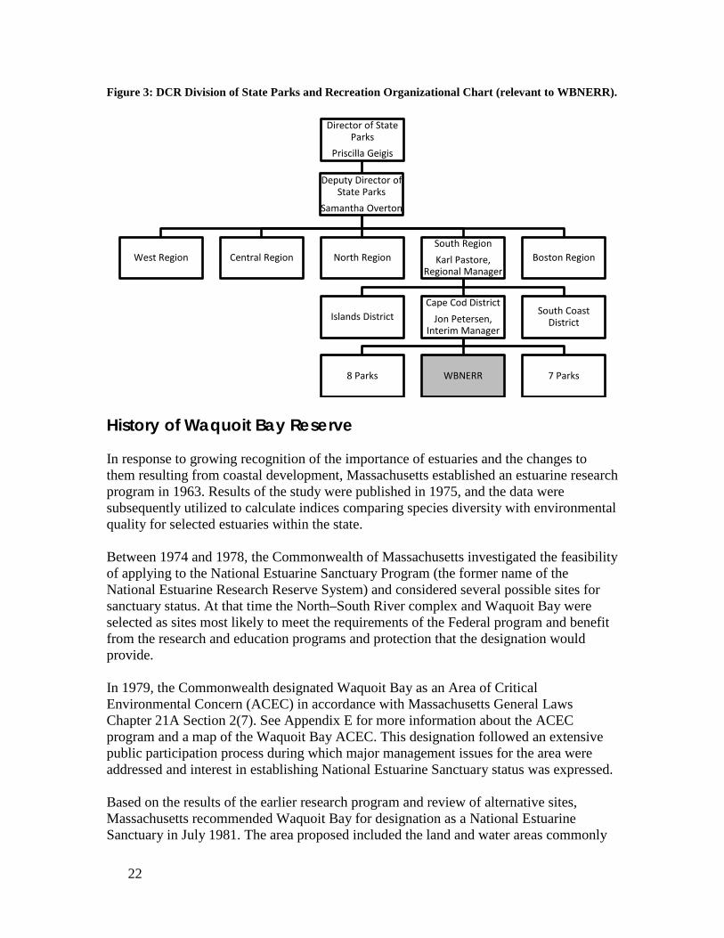
Figure 3: DCR Division of State Parks and Recreation Organizational Chart (relevant to WBNERR).
History of Waquoit Bay Reserve In response to growing recognition of the importance of estuaries and the changes to them resulting from coastal development, Massachusetts established an estuarine research program in 1963. Results of the study were published in 1975, and the data were subsequently utilized to calculate indices comparing species diversity with environmental quality for selected estuaries within the state. Between 1974 and 1978, the Commonwealth of Massachusetts investigated the feasibility of applying to the National Estuarine Sanctuary Program (the former name of the National Estuarine Research Reserve System) and considered several possible sites for sanctuary status. At that time the North–South River complex and Waquoit Bay were selected as sites most likely to meet the requirements of the Federal program and benefit from the research and education programs and protection that the designation would provide. In 1979, the Commonwealth designated Waquoit Bay as an Area of Critical Environmental Concern (ACEC) in accordance with Massachusetts General Laws Chapter 21A Section 2(7). See Appendix E for more information about the ACEC program and a map of the Waquoit Bay ACEC. This designation followed an extensive public participation process during which major management issues for the area were addressed and interest in establishing National Estuarine Sanctuary status was expressed. Based on the results of the earlier research program and review of alternative sites, Massachusetts recommended Waquoit Bay for designation as a National Estuarine Sanctuary in July 1981. The area proposed included the land and water areas commonly
Director of State Parks
Priscilla Geigis
Deputy Director of State Parks
Samantha Overton
West Region Central Region North Region South Region Karl Pastore,
Regional Manager
Islands District Cape Cod District
Jon Petersen, Interim Manager
8 Parks WBNERR 7 Parks
South Coast District
Boston Region
22

known as Waquoit Bay, Washburn Island, South Cape Beach, the Sargent Estate, Sage Lot Pond, Flat Pond, Hamblin Pond, Jehu Pond and the major salt marshes immediately adjacent to those areas. In 1981, the Commonwealth applied for and was awarded a Federal “pre-acquisition” grant for further evaluation of the site, collection of information necessary for the preparation of a Management Plan and a draft environmental impact statement, and preliminary acquisition activities. In December 1982, the Commonwealth acquired South Cape Beach and in June 1983, the Commonwealth acquired Washburn Island. Based on this commitment to protect significant components of the Waquoit Bay ecosystem, the Commonwealth successfully applied for additional federal assistance to develop Waquoit Bay as a National Estuarine Sanctuary. The NOAA funding was used to acquire, in November of 1987, the 21-acres of wetlands, waters, and uplands of the Sargent Estate at the head of the Bay to serve as the Reserve Visitor Center and Headquarters. The NOAA funding was also used for construction of necessary support facilities and equipment for Reserve research and education. Formal designation of the Waquoit Bay National Estuarine Research Reserve took place in June 1988. Boundaries The Reserve continues to pursue strategic land acquisitions with willing sellers that may expand the Reserve boundary in the future. Focus for acquisitions is in the WBNERR Stewardship Focus Area and is guided by the Reserve’s Land Acquisition Plan (Appendix J). The Stewardship Focus Area (SFA) is the geographic planning area identified by WBNERR that contains those lands and resources that, if altered, are likely to change (improve or degrade) the quality of resources and/or uses within the Reserve boundary. The SFA includes the designated lands and waters of the Reserve, as well as other lands as defined below. Research at WBNERR has clearly demonstrated that changes in land use within the watershed are capable of causing drastic degradation of natural resources within the Waquoit Bay estuary. Thus, WBNERR is concerned with land use planning throughout the Waquoit Bay watershed, particularly activities that are known to increase watershed derived nitrogen loads to the estuary (i.e., discharge of nitrogen to the atmosphere, land, surface water or groundwater) and all lands within the watershed of the Waquoit Bay estuarine system are included in the SFA. Most land within the Waquoit Bay watershed that has not been set aside for conservation has already been developed for residential, commercial, retail and military uses. Nonetheless, several parcels containing important habitat or other attributes of value to advance WBNERR’s mission still exist. Additionally, there are some parcels that lie outside of the Waquoit Bay watershed that have been included in the Mashpee National Wildlife Refuge (MNWR) boundary (Figure 4) because they are the last remaining contiguous parcels of representative coastal terrestrial and freshwater wetland habitats remaining in the vicinity of the estuary.
23

WBNERR has an interest in the ecological integrity of the habitats contained on these lands as well. Therefore, all lands included in the MNWR land acquisition boundary are included in the WBNERR SFA. The WBNERR Stewardship Focus Area (Figure 4) thus includes all of the following areas:
• All designated Reserve lands and waters, • All land parcels that lie (at least partially) inside the watershed boundary of
the Waquoit Bay estuarine system. • All land parcels within the MNWR land acquisition boundary.
Boundary Change With the formal acceptance of the 2013 Management Plan, two new properties purchased over the past five years are being formally added to the Waquoit Bay NERR - the 11.4-acre Caleb Pond parcel, and 12.4-acre addition to the Quashnet River lands (Figure 4).
24

Figure 4: WBNERR Properties.
25

Caleb Pond parcel The Caleb Pond Parcel, purchased in part with NOAA PAC funds, is located in the northeast corner of Waquoit Bay within the Stewardship Focus Area and was the largest single undeveloped privately held parcel remaining on the Bay. The land consists of upland coastal pine-oak forest habitat with a fringing salt marsh on Caleb Pond, a saltwater embayment of Waquoit Bay. The parcel contains water frontage on the Caleb Pond/Waquoit Bay estuary, Bourne Pond (a freshwater glacial kettle pond), and a small connecting stream, all of which are waters currently designated within the Waquoit Bay NERR. The stream contains diadromous fish runs of American eel and historically supported an anadromous river herring run. The parcel is immediately south of Waquoit Village and just east of the WBNERR headquarters property. The Caleb Pond Parcel is separated from the WBNERR headquarters property by only a single parcel. This parcel, the Simpson property, has recently been protected through a conservation restriction (easement) negotiated by one of WBNERR’s local land protection partners (The 300 Committee Land Trust). Acquisition of the Caleb Pond Parcel, combined with this recent conservation restriction and the existing WBNERR Headquarters property creates an area of over 40 acres of contiguous protected lands stretching across the head of Waquoit Bay. Quashnet River addition The addition to the Quashnet River Component is especially valuable for protection of terrestrial, groundwater, aquatic systems. The parcel also has a high recreation value. It is located at the entrance to the large, well-used Quashnet River Area and is immediately adjacent to a large (2000+ acre) complex of conservation lands, managed under the MNWR partnership, making it part of a contiguous unfragmented area, valuable as wildlife habitat and corridor. This parcel had a priority ranking in the land protection plans for both WBNERR and the MNWR. The Martin Road gate and parking area is the primary entrance to the 427 acre Quashnet River Component (the heart of this larger contiguous land area), owned and managed by the state as part of WBNERR. Programmatic and ecological value to the Reserve The addition of these lands to the Reserve’s boundary is consistent with the goals of the Reserve System. Specifically, the expansion increases the amount of protected land within the rapidly developing Waquoit Bay watershed (Error! Reference source not found.). These lands represent a stable environment for research and stewardship. They also provide additional opportunities for education, training and interpretive programs leading to enhanced public understanding of estuarine areas and coastal management issues. The Caleb Pond parcel is a particularly interesting addition because it is within easy walking and kayaking distance of Reserve headquarters making it ideal for educational purposes. Furthermore, by protecting these lands from development, the Reserve has reduced potential nitrogen loading to the Waquoit Bay estuarine system.
26

Figu
re 5
: Lan
d U
se C
hang
e in
the
Waq
uoit
Bay
Wat
ersh
ed.
27

In response to inquiries regarding property acreage and boundary lines, the Reserve boundary designation and Reserve properties owned by the Commonwealth of Massachusetts have undergone careful review using GIS-based town parcel data (Towns of Falmouth and Mashpee, 2009). All areas listed in previous Management Plans shall be considered in error in deference to these updated figures. With the addition of 23.8 acres of newly acquired lands, the Reserve now has a total area of 2,837.2 acres. This includes 1,288.7 acres of lands in the Reserve “Core” area, where lands are protected and offer a stable research platform (hereafter referred to as “WBNERR Property”). In addition, the Reserve’s “Buffer” area, in which resources are protected by the laws and regulations described in Appendix F, includes 1,376.3 acres of waters and 172.2 acres of privately owned salt marshes or “major marsh areas” (Figure 6). The coastal marsh in-holdings are considered integral to overall estuarine integrity as explained in the original designation - refer to 1989 and 2000 Management Plans - and therefore, are incorporated in the “Buffer” zone. Figure 6: Property Boundary, Reserve Core and Buffer Areas
28

“Core” lands protected within the Reserve are distributed among nine distinct areas (Figure 4): Based on town parcel acreage (2009)
• Headquarters, 20.7 acres • Childs River, 18.6 acres • Washburn Island, 281.7 acres • Phinney Property, 10.0 acres • Quashnet Woods, 427.4 acres (12.4 acres added to this Component since the last
Management Plan) • North Quashnet, 24.4 acres • Abigail Brook, 35.2 acres • South Cape Beach State Park, 459.6 acres • Caleb Pond property, 11.4 acres (acquired since the last Management Plan)
Description of properties and assets Headquarters The Reserve Headquarters contains oak/pine forest, a saltwater pond, grassland meadow, and the coastal bluff overlooking Waquoit Bay. The site of the historic Sargent estate, this property is generally utilized as a “campus” with emphasis on research, education/outreach and administration. The old mansion, Carriage House, Boat House, and caretaker’s house are now utilized for staff offices, a Visitor Center, classroom and laboratory facilities, meeting rooms, and dorm-style housing. The Headquarters Site provides access to a wide range of activities for the public. The Visitor Center, Boat House, and Carriage House host many structured educational, training and interpretive activities. Additionally, casual visitors can follow a short trail through the woods and around a scenic overlook of the Bay and nearby coastal pond. A trail guide featuring the walking trails at the Headquarters Site, Washburn Island, and South Cape Beach State Park is available in the Visitors Center. Exhibits at the Visitor Center offer additional information to walk-in visitors. Construction of a new maintenance building and other campus renovations are underway in summer 2013.
Visitor Center/Main House The Visitor Center/Main House is the principal point of contact for visitors to the Reserve and provides office and meeting space for the staff of the Reserve. The first floor is handicapped-accessible and contains a large meeting room and three smaller rooms. Of the smaller rooms, two make up the Exhibit Center and the third is a storage room. The first floor also has two handicapped-accessible toilets. The second floor consists of offices, a small kitchen/lunchroom, and a bathroom for Reserve staff. The cellar and attic are used for storage. Carriage House The Carriage House consists of 13 rooms; four are used for research, one large room is set up as a classroom/laboratory. Two rooms are handicapped-accessible bathrooms. There is a furnace room, a two-bay storage area, a two-bay shop area,
29

an office, an employee toilet, and a break room used by maintenance staff. The building sits on a concrete slab and has attic storage space. Renovations underway in 2013 will change the use of this building. Maintenance functions will be moved to the new building under construction. One of the storage bays will be turned into a second classroom. The other storage bay will be used to support the research and stewardship. The break room will be used for research storage, freeing up the back storage room for a lab for visiting researchers. The small, unused shower room in the lab space will be outfitted for clean glass washing. New Maintenance Building This new building, located near the Gate House, addresses Objective 5.11c in the previous Management Plan and in the 2003-2007 312 Evaluation. It contains one large garage bay for truck and boat maintenance and storage, and a smaller bay for equipment maintenance. There is a workshop, office, staff bathroom, and a storage loft. The area around the building will be used for trailer, lumber and other storage. Relocating maintenance functions to the periphery of the site significantly improves the function of the Carriage House for core programs, provide needed indoor work space for vehicles and boats, and dramatically improve the aesthetics and safety of the central campus by removal of maintenance items stored outdoors. Gate House The Gate House is used primarily as a dormitory for visiting students, scientists, and others. It consists of two floors with a small cellar and small attic. The first floor is fully handicapped-accessible and has one bedroom, 2 full baths, a kitchen, and dining and sitting rooms. There are two bedrooms and a full bath on the second floor. Bunk beds in the three bedrooms provide sleeping accommodations for 12 people. Boat House The Boat House consists of one floor of living area and a cellar. The main floor has four rooms: one large space used as a meeting room, one room used for office space, a small kitchen, and a bathroom. The cellar is used for boat and research equipment storage.
South Cape Beach State Park Acquired by the Commonwealth in 1982, the 460 acres which make up South Cape Beach State Park are located between Waquoit Bay and Vineyard Sound, to the east of the entrance to the Bay. The beach serves as a nesting ground for protected species such as piping plover and least tern. Sage Lot and Flat Ponds are salt ponds to the east of the Bay that are part of South Cape Beach State Park. The barrier beach and fragile dune systems provide the Bay and ponds some protection against the dynamic shore, which changes with the season as well as in response to coastal storms and hurricanes.
30

The South Cape Beach area includes South Cape Beach State Park and a beach owned and operated by the Town of Mashpee, which is not is not part of the Reserve. South Cape Beach State Park provides a wide range of ocean-side recreational opportunities including access to beaches and trails. Several types of interpretive activities take place here, including regularly scheduled interpretive walks. Various research projects are also conducted at South Cape Beach, including the newly created salt marsh observatory and the NERRS Science Collaborative project looking at greenhouse gas exchange in salt marshes. Parking, requiring a fee or appropriate permit during the summer, is available at the State beach parking lot or the Town of Mashpee parking lot. There is a beachfront area, boardwalks to the beach, a contact station, three port-a-john toilets (seasonally), and a 200-car parking area. For visitors with limited mobility, a specially designed “sand chair” (a wide-tire wheelchair) is available at the State beach. Trails used in education programs and by visitors traverse some areas of the Park. In 2010-11, improvements were made to those trails including boardwalks through wetland areas and two viewing platforms. This year we plan to build changing booths, and add benches and other visitor amenities. We also plan to capitalize on the large visitorship by installing more informational and interpretive signage. Washburn Island One of the last large undeveloped coastal properties on Cape Cod and a jewel within the Reserve, Washburn Island is bordered by Waquoit Bay proper, the Seapit River and Eel Pond. Habitats consist of a barrier beach, oak and pine forest, and coastal salt ponds. Most of the present vegetation on the site dates from after World War II. The Commonwealth acquired the 282-acre island in 1983. At that time there were no structures on the island. Today, the island has ten campsites supported by three composting toilets - nine family sites and one group site that is limited to 25 people. There are also trails on the island for nature viewing and exploration. The island, while accessible only by water, is very popular with day users and campers. Most visitors come by private boat - they either beach their boats or anchor and wade ashore. During the summer, the Reserve offers roving interpretation for boaters, and special programs. Three Island Managers live on the island in the summer and are responsible for managing camping on the island and providing roving interpretation. Camping permits (requiring a small fee) are available through an on-line reservation service, ReserveAmerica.com or by calling 1-877-422-6762. Permits are available May through mid-October (Columbus Day). State regulations restrict the length of stay at a campsite to no more than fourteen consecutive days (304 CMR 12:24(5)(a)) between Memorial Day and Labor Day. Quashnet Woods Property The Quashnet River is the largest source of fresh water to the Bay and provides important habitat for brook trout, herring and eels. Upland forests comprise most of the property. The 10-acre Phinney parcel is located near the Quashnet River in the central portion of
31

the Bay’s watershed. The property includes pine/oak woodland characteristic of coastal uplands in the area. The 31-acre NStar parcel is also located near the Quashnet River in the central portion of the Bay’s watershed. It is immediately adjacent to the Reserve’s Quashnet River Area property and includes a variety of coastal upland and wetland habitats, including some vernal pool and freshwater wetland habitats not previously represented in the Reserve. This property is jointly managed by the Reserve and the Massachusetts Department of Fisheries and Wildlife. Presently there is a limited parking area, interpretive kiosk, a 2.5 mile long trail running along the Quashnet River, and two shorter trails to the west of the river. The trails are accessible through the Martin Road or the Whiting Road gates. An existing dirt road forms one side of the main trail. It then crosses over the river at a herring run and circles back as a path through the forest. The trails are not handicapped-accessible. Childs River The two Childs River properties total 19 acres and straddle the Childs River (the second largest tributary to the Bay) just upstream of tidal influence. The property includes coastal pine/oak woodland habitat and unique coastal low gradient stream habitat important to multiple migratory fish species. While there are no official trails on the Childs River property, the public is permitted to hike and explore. Regulations guiding usage are posted on signs at the property’s boundaries. Abigail Brook The 35-acre Abigail Brook parcel is located immediately adjacent to the easternmost portion of the Reserve in the vicinity of Upper Great River. This property includes coastal upland pine/oak woodland and important riparian buffer to the adjacent Abigail Brook and its associated wetlands. The Abigail Brook property has an existing public trail that is maintained by volunteers. Regulations guiding usage are posted on signs at the property’s boundaries. Assets of Waquoit Bay National Estuarine Research Reserve Natural Resources The Waquoit Bay Reserve on Cape Cod Massachusetts is composed of open waters, salt and freshwater ponds and marshes, barrier beaches, sand dunes, rivers, mixed pine and oak forests, and sandplain grasslands. The more than 2,700 acres of aquatic and terrestrial habitat in the Reserve are representative of the New England portion of the Virginian biogeographic province. The Reserve's natural features are fully described in The Ecology of the Waquoit Bay National Estuarine Research Reserve, edited by Margaret A. Geist and published in 1996. Portions are excerpted below. Waquoit Bay, with an area of approximately 825 acres, is the dominant feature of the Reserve. With a maximum depth of 8.9 feet and mean depth of 2.6 feet, the shallow bay is warmer in the summer and colder in the winter than neighboring Vineyard Sound. Salinity ranges from 0 parts per thousand (ppt) in the upper reaches of rivers to about 32
32

ppt in the open Bay. Eelgrass, Zostera marina, covered extensive areas of the Waquoit Bay estuarine complex until recent decades when disease and eutrophication caused rapid declines in abundance and distribution to the point where only Sage Lot Pond and Tim’s Pond contain small remnant populations. The Bay is home to resident finfish populations, serves as a nursery area for other species of finfish, and supports a cadre of diadromous fish. Invertebrates are also well represented by species such as quahogs, Mercenaria mercenaria, soft-shell clams, Mya arenaria, and blue crab, Callinectes sapidus. Other species of the open water include sea ducks in winter, ospreys, Pandion haliaretus, each spring and summer, and harbor seals, Phoca vitulina. Approximately 300 acres of salt marsh are located within the Reserve, mainly around Hamblin, Jehu, and Sage Lot ponds, at the head of Great River, along the shores of Washburn Island, at the head of Waquoit Bay and Eel Pond, on the new Caleb Pond parcel, and at the mouth of the Childs and Moonakis rivers. Estuarine channels and tidal creek habitats link the open bay environment to the smaller, more tidally restricted salt ponds and their associated salt marshes. The estuarine channels and tidal creek beds within the Reserve are primarily sandy mud with a layer of macroalgae growing over the bottom. They are home to ribbed mussels, Geukensia demissa, blue crabs, Callinectes sapidus, and lady crabs, Ovalipes ocellatus. About 2.5 miles of beach and sand dunes extend along the southern shore of Washburn Island and South Cape Beach. A portion of the barrier beach at South Cape Beach State Park is used for public recreation. The balance is undeveloped and supports a diverse habitats and species including coastal shrublands, pitch pine, beach plums, Prunus maritime, and beach roses. These communites are also found on Washburn Island. The fresh water wetlands of the Waquoit Bay watershed are rich in plant and animal species. At South Cape Beach, freshwater marsh species include the common cattail, Typha latifolia, and reed grass, Phragmites australis, as well as twig rush, Cladium marascoides, and water lily, Nymphaea odorata. Patches of bogs have such species as sheep laurel, Kalmia augstifolia, sweet gale, Myrica gale, and Sphagnum sp. Many waterfowl are solely dependent upon wetlands for their breeding, feeding and migratory needs. Ospreys forage for fish in salt and freshwater areas. Many upland wildlife species, including game and song birds, opossum, raccoons and white-tailed deer, are seasonally dependent on wetlands. Coastal plain streams provide important sources of water for upland species and are prime habitat for fish, turtles, ducks and geese. The Quashnet River is an important habitat for alewife, Alosa pseudoharengus, blueback herring, A. aestivalis, and American eel, Anguilla rostrata, and holds one of the last remaining sea-run brook trout, Salvetinus fontinalis, populations in the United States.
33
In addition to aquatic resources, the Reserve encompasses 1,286 acres of upland, including notable pine barrens and sandplain grasslands. Pitch pine/scrub oak, Pinus rigida/ Quercus illicifolia, barrens occur on dry, acidic, nutrient poor, well drained soils in the Waquoit Bay watershed and other coastal outwash plains. Examples of pitch pine/scrub oak barrens are found throughout the Reserve. Typically, a dense understory of scrub oaks and huckleberry, Gaylussacia baccata, grows beneath the pitch pines and excludes other plants. Often patches of lowbush blueberry, Vaccinium augustifolium, bearberry, Arctostaphylos uva-ursi, sweetfern, Comptonia peregrine, or lichen grow in the open spaces between oaks. This pine barrens community has adapted to occasional fires for its maintenance as nutrients, generally scarce in the poor soils, become more available in the ashes of a fire. Sandplain grasslands are open, treeless grasslands on dry, sandy soils. These grasslands are found in areas of glacial deposits in southeastern Massachusetts, including Cape Cod and the Islands, and a few places in Connecticut. Prairie grasses are the dominant species of these grasslands. Bird’s foot violet, Viola pedata, which grows extensively on the Sargent Estate within the Waquoit Bay Reserve, is an indicator of sandplain grasslands. A large population of New England blazing star, Liatris scariosa var. novae-angliae, inhabits Washburn Island. This species is listed as a Species of Special Concern in Massachusetts. The federally endangered sandplain gerardia, Agalinis acuta, is also found within the Reserve. Archeological, Historical, and Cultural Resources Five prehistoric sites have been identified on WBNERR land in Falmouth and many more are known on adjacent lands. In the vicinity of the Reserve, sites which range in age from possibly as early as the Paleo Indian Period (12,000 to 9,000 BP) to the Contact Period (450 BP) may be expected to have survived on undeveloped land. When considered in the context of 12,000 years of human habitation, all of WBNERR must be considered archaeologically sensitive for prehistoric resources. Artifacts collected on Washburn Island indicate that the island was recurrently occupied over a period of as much as 5,500 years. Artifacts inventoried from the Island (site 19-BN-575) indicate Native American activity from Late Archaic (ca. 6,000 – 3,000 years ago), Early and Middle Woodland (3,000 - 1,100 years ago), and Late Woodland (1,100 – 400 years ago) times. The range of implements and edge tools suggests that Washburn Island served as a habitation site as opposed to some type of special purpose site, e.g., kill or butchering. The sites also may have served in part as lithic workshops, as they have yielded quantities of lithic flaking debris, cores and preforms, indicating stone tool manufacturing. The remains of a 30-year old Native American from an unknown temporal period were also found on Washburn Island. There are vestiges of more recent history on Reserve land as well. Cellar holes and building rubble mark the location of two of three 19th century farmsteads on Washburn Island. A brick foundation is all that remains of an elaborate estate that was built in 1900 by the son of the founder of the Bryant & Sturges shipping firm, which is credited with
34

opening up the Pacific Northwest to trade. The estate was destroyed by fire in 1926. Some concrete exposed at the dune’s edge at the far southern end of the island has been identified as the site of a garage belonging to a family that had their beach cottage moved from the Island to Central Avenue in Falmouth in 1942, before the army took possession of the island. Between 1942 and 1945, the island served as the Camp Edward’s Engineer Amphibian Command. In this capacity the island became one of the Army’s principle amphibious training grounds. Washburn Island has been referred to as “the cradle of our European invasion” (Enterprise 1953), as the men who trained on its shores went on to spearhead the assaults at Normandy, France; Oran, Algeria; and Salerno, Italy. Toward the end of the war, the base was used as an “R & R” center for convalescing soldiers from nearby Camp Edwards. Many deteriorating concrete foundations and slabs located toward the northern and central portion of the island are associated with this military use. The asphalt roads and the bridge abutments on the northwest shore of the island are also military features. On the mainland, at the head of Waquoit Bay, is the Reserve’s headquarters site, sometimes referred to as the Sargent Estate. The main house was built between 1880 and 1890 by Ignatious Sargent in the Shingle Style of late Victorian construction and used as a summer “cottage” for family vacations until it was damaged by the 1938 hurricane. The mansion features sixteen rooms with ornate fireplaces and mantels and exotic woods on the first two floors. Following the 1938 hurricane, the building was boarded up for almost fifty years until it was acquired by the Commonwealth of Massachusetts in 1987 for use by the Reserve. The estate also includes a carriage house, gate house, and boat house. All of these buildings were adapted for new uses by the Reserve. The Reserve’s headquarters are located within the Waquoit National Historic District. The Historic District was established in 2004 in recognition of the area’s significance as an isolated Falmouth Village that reached the high point of its development in the 1850s with industrial, marine, agricultural, and summer tourism components. In 2010, erosion from a series of storms exposed 111 stumps from an ancient red cedar forest in the inter- and subtidal area of South Cape Beach. These stumps have since been carbon-dated at 400-1200 years old. Proximity to the South Cape Beach salt marsh research site and upland forest has made this an excellent educational setting to illustrate coastal change and sea level rise.
35

Chapter 2: Understanding Coastal Ecosystems
Goal 1: Improve the understanding of coastal ecosystems and the human influences on them. Overview Goal 1 expresses the Reserve’s important role in fostering research on coastal ecosystems and the human impacts on them. The Reserve fulfils this role by providing a dedicated, stable natural ecosystem representative of the biogeographic region as a platform for scientific investigation, providing scientists with infrastructure and information that supports and guides their work, and communicating the results to coastal communities to aid their decision-making. For infrastructure, the Reserve provides researchers with an estuarine base of operations, facilities, and a range of logistical support. For information, the Reserve maintains an intensive research and monitoring program and research archive aimed at providing scientists with a rich set of current and past environmental and societal data to create a broad and detailed context for their studies. The Reserve also obtains and communicates information regarding the important coastal resource management issues in the region to help focus research on community needs. Research results provide feedback to adaptive resource management activities at the Reserve and are incorporated into the Reserve’s training and education programs. Once every five years a workgroup will be assembled to review the WBNERR research priorities as an integral part of its Management Planning process. This group will be comprised of RAC members, representatives from Massachusetts state and local government agencies who have coastal resource management responsibilities (e.g., DCR, CZM, DEP, NEP, DMF, Town DNRs), and representatives from regional science institutions (e.g., UMASS, WHOI, MBL) and agencies (e.g., SeaGrant). The Reserve’s research priorities will also be informed by NOAA guidance, and NERRS Research Goals, Research Priorities and Focus Areas (Figure 7).
36

Research is conducted internally by Reserve scientific and Stewardship staff, externally by visiting scientists from other institutions and agencies, and in collaborations or partnerships between the Reserve and other scientists, institutions and agencies. Internal research and monitoring have the primary mission of improving the Reserve’s capacity as a natural laboratory by obtaining and providing critical environmental, historical and social information on the Waquoit Bay estuarine system and adjacent marine and terrestrial systems that influence it. External research by visiting scientists addresses the
Research at Waquoit Bay NERR Priorities include:
• Characterization of the Waquoit Bay estuarine system as it exists today and its evolution over time, including its natural variability and impacts from human activities.
• The response of coastal environments to: o Climate change, sea level rise and storm events o Watershed change and variability, and inputs such as excess nutrients and other
contaminants o Ocean and Shelf change and variability such as ocean-acidification and invasive species
• Environmental services provided by estuarine habitats and ecosystems Research in the NERRS: Priorities include: Federal regulations, 15 C.F.R. Part 921.50 (a), specify the purposes for which research funds are to be used:
• Support management-related research that will enhance scientific understanding of the Reserve ecosystem,
• Provide information needed by Reserve managers and coastal ecosystem policy-makers, and • Improve public awareness and understanding of estuarine ecosystems and estuarine
management issues. Goals and Objectives:
• Address coastal management issues identified as significant through coordinated estuarine research within the System;
• Promote federal, state, public and private use of one or more Reserves within the System when such entities conduct estuarine research; and
• Conduct and coordinate estuarine research within the System, gathering and making available information necessary for improved understanding and management of estuarine areas.
• Expand capacity to monitor changes in water quality and quantity, habitat, and biological indicators in response to land use and climate change drivers.
• Improve understanding of the effects of climate change and coastal pollution on estuarine and coastal ecology, ecosystem processes, and habitat function.
• Characterize coastal watersheds and estuary ecosystems and quantify ecosystem services to support ecosystem-based management of natural and built communities.
• Increase social science research and use of social information to foster coastal stewards that value and protect estuaries.
• • NERRS Scientific investigations improve understanding and inform decisions affecting
estuaries and coastal watersheds.(from the NERRS 2011-2016 Strategic Plan)
Figure 7: Summary of Statements Guiding WBNERR and NERRS Research and Monitoring.
37

broad range of natural and social science problems from basic research on the biology and physical environment of estuaries to applied research addressing specific coastal management problems. Collaborative research, carried out by the Reserve in partnership with outside entities, is focused on improving the characterization of the Waquoit Bay system or addressing pressing local and regional coastal management issues. Research partnerships, in particular, provide the Reserve with significant leverage in focusing research on critical areas and concerns. Linkages and cooperative efforts with universities and other institutions, both governmental and non-governmental, help to highlight the Reserve as a convenient and effective site for coastal research along with increasing the awareness of coastal resource management needs within the research community. Research at the Reserve is also driven by the National Estuarine Research Reserve System’s Research and Monitoring Plan. Research and Monitoring Plan [§921.50] The Reserve system provides a mechanism for addressing scientific and technical aspects of coastal management problems through a comprehensive, interdisciplinary, and coordinated approach. Research and monitoring programs, including the development of baseline information, form the basis of this approach. Reserve research and monitoring activities are guided by national plans that identify goals, priorities, and implementation strategies for these programs. This approach, when used in combination with the education and outreach programs, will help ensure the availability of scientific information that has long-term, system-wide consistency and utility for managers and members of the public to use in protecting or improving natural processes in their estuaries. As of 2013, the Reserve’s research and monitoring program is enhanced by two national components 1) NERRS Science Collaborative and 2) the NERR System-Wide Monitoring Program (SWMP). NERRS Science Collaborative The NERRS Science Collaborative -- a partnership between the Coastal Office and the University of New Hampshire -- directly supports (funds) NERRS-focused research that seeks broad-based, collaborative solutions to important coastal management issues. Funding guidance specifically requires collaboration between scientists and end-users in the development of projects to ensure that the science generated meets the needs of coastal decision makers. Projects must also be NERR-driven, and respond to pressing coastal management needs in the Reserve’s region.
38

System-Wide Monitoring Program The Reserve implements all “core elements” and some “elective elements” as defined by the System-Wide Monitoring Plan (See http://nerrs.noaa.gov/Doc/PDF/Research/2011SWMPPlan.pdf. SWMP provides standardized data on national estuarine environmental trends while allowing the flexibility to assess coastal management issues of regional or local concern. The principal mission of the monitoring program is to develop quantitative measurements of short-term variability and long-term changes in the integrity and biodiversity of representative estuarine ecosystems and coastal watersheds for the purposes of contributing to effective coastal zone management. The program is designed to enhance the value and vision of the Reserves as a system of national reference sites. Currently, the SWMP program is described as composed of five primary “toolboxes: • Abiotic – standard protocols, parameters, and approaches that describe the physical
environment including weather, water quality, dissolved nutrients, hydrological, and sediment related parameters;
• Biotic – standard protocols, parameters, and approaches that describe biological
communities, including estuarine vegetated habitats, benthos, plankton, nekton, and birds;
• Mapping – standard protocols, parameters, and approaches that establish spatial reference frames to national geodetic networks for reserve and watershed-scale spatial data products;
• Data Analysis and Synthesis – standard protocols and approaches that provide a means of analyzing and interpreting SWMP data and placing it in the context of specific and relevant coastal management issues;
• Translation and Education– common approaches for communicating SWMP data and products to a wide variety of audiences, including independent researchers, reserve scientists, educators, recreational visitors, and coastal decision makers.
SWMP Abiotic, Biotic and Mapping data are archived at the NERRS Centralized Data Management Office (CDMO) at the Belle W. Baruch Institute for Marine Biology and Coastal Research of the University of South Carolina. CDMO provides additional quality control for data and metadata and they compile and disseminate the data and summary statistics via the Web (http://cdmo.baruch.sc.edu) where researchers, coastal managers and educators readily access the information. The metadata meets the standards of the Federal Geographical Data Committee.
39

Monitoring at WBNERR Environmental monitoring is central to the mission of the Reserve and is a major activity to which it devotes significant resources of equipment, supplies and personnel time. Because of the Reserve’s committed presence to a specific piece of water and land, it is positioned to carry out intensive monitoring critical to detecting environmental variability and long-term change that would otherwise be difficult to accomplish within the short-term (2-3 years), hypothesis-driven venue typical of most research efforts. Most of the Reserve’s monitoring programs (SWMP and non-SWMP) are supervised by Research and Stewardship staff and carried out by Reserve staff, citizen volunteers and in some cases, staff from other government agencies and institutions. In 2012, monitoring at the Reserve consists of the following programs (refer to Figure 8 for monitoring sites).
1. SWMP The SWMP serves as the core framework of the Reserve’s natural laboratory, supplying real-time and archived water column, meteorological and biological information to Reserve staff, visiting researchers, resource managers, aquaculture businesses and the surrounding communities.
a. SWMP Abiotic
i. Water Quality Component 1. Sonde station Element : continuous (year-round) 15-minute
measurements at four long-term monitoring stations (Figure B). The parameters measured using YSI data sondes (currently 6600 V2 series, but expected to transition to YSI EXO series by 2016) are water temperature, conductivity, salinity, dissolved oxygen, water level, pH, turbidity.and fluorescence/Chla (an elective parameter. The long-term SWMP station called Menauhant, is telemetered and data uplinked every hour to NOAA’s GOES satellite and available in real-time on the web through a number of portals including NOAA’s National Buoy Data Center, Hydrometerological Automated Data System, the NERRS Central Data management Office.
2. Water Chemistry Element: Monthly collections are made at the four long-term water column monitoring stations, and one diel set (25 hours / 2 full tidal cycles) is also carried out simultaneously at one of these stations. The parameters measured directly are the dissolved inorganic nitrogen (DIN) species NO2, NO3 and NH4), total dissolved nitrogen (TDN) and particulate carbon and nitrogen (PC/PN), dissolved inorganic phosphorus (PO4), silica (SiO2) and Chlorophyll (Chla). From the measurements of the nitrogen species, Total nitrogen (TN) and dissolved organic nitrogen
40

(DON) are derived. ii. Meteorological Component: continuous 15-minute
measurements at one station at the Reserve headquarters (Carriage House). The parameters measured are air temperature, relative humidity, barometric pressure, wind speed and direction, precipitation, and photosynthetically active radiation (PAR) and Total Solar (Short Wave) Radiation (an elective parameter)). This station is telemetered to NOAA’s GOES satellite and accessible real-time at the web portals listed above.
Figure 8: Waquoit Bay NERR Monitoring Sites.
SWMP Biotic : In 2004, as part of SWMP, the Reserve began monitoring 1) submerged aquatic vegetation - eelgrass (SAV) and macroalgae (MAL), and 2) emergent wetlands vegetation. The SAV / MAL surveys using Ponar benthic grabs at 230 stations were also done in 2007 and 2011 and surveys are expected to be repeated about every 3 years. At each station SAV/MAL survey records biomass for each species present and a sediment size profile. In 2010-11, as part of the start-up of the SWMP emergent wetlands biomonitoring component, the Reserve completed the installation of 150 permanent plots and associated infrastructure for annual monitoring of salt
41

marsh vegetation and completed its first annual survey (2011) using the NERRS SWMP protocols. These vegetation plots are within the Reserve’s designated “Salt Marsh Observatory” developed as part of the NERRS Sentinel Site initiative, which include a precise vertical control network, sediment elevation tables (SETs), digital elevation models (DEMs), a water level monitoring network and on-site meteorological station.
b. Mapping: In 2004, the salt marsh and wetland vegetative communities of
the entire Waquoit Bay estuarine system were mapped using aerial imagery and GIS. These data have since been linked with other available habitat information to complete a baseline habitat map for the Reserve. In 2012, aerial imagery of the Reserve was repeated, and efforts are underway to map and compare vegetation and habitat changes over this seven year period from 2004 to 2012. Mapping of the Reserve’s emergent wetlands vegetation and habitat is expected to be repeated about every 5 to10 years, contingent on available funding. See also Objective 1.3c.
2. Non-SWMP Monitoring: The Reserve has a number of monitoring programs,
many in partnership with volunteers or other agencies. A description of these programs is in Appendix G.
Integrated Project #2: Sentinel Site: Salt Marsh Observatory In 2010-11, as part of the start-up of the SWMP emergent wetlands biomonitoring component, the Reserve established a Sentinel Site, called the Salt Marsh Observatory (SMO), in the salt marsh at its South Cape Beach component. Infrastructure includes a precision vertical control network, digital elevation model (DEM), permanent salt marsh vegetation transects/plots, sediment elevation tables (SETs), a water level monitoring network and on-site meteorological station. The site is designed to:
• Characterize existing salt marsh habitats and processes and their natural variability.
• Study effects of climate change, sea level rise and storms on the salt marsh. • Encourage intensive, high-impact salt marsh research by providing scientists
with supporting infrastructure and a rich environmental database. • Generate useful information for the management of coastal wetlands. • Test new technologies, sensors, or equipment to detect abiotic change and
community response to environmental stressors. • Provide information for use in education and training programs.
42

Waquoit Bay Reserve Research and Monitoring Objectives
This Objective remains unchanged from the last Management Plan as it is an ongoing need. The Research Coordinator stays abreast of NERRS research goals, priorities, and focus areas. Using this knowledge, the Reserve identifies and prioritizes research topics and critical coastal resource management concerns through literature reviews and regular dialogue among researchers, resource managers (including DCR and Massachusetts Coastal Zone Management staff), and representatives of coastal communities. The CTP Coordinator, working with other Reserve staff, organizes meetings, workshops and other events for this purpose. Informal discussions also occur on a regular basis, allowing research priorities to evolve in an organic and often rapidly changing manner. This combination of critical thought and flexibility to respond to emerging issues allows the Reserve to catalog research needs on an ongoing basis. A list of currently recognized management needs has been developed through a CTP Needs Assessment and discussions with staff and the coastal management and scientific communities. In the 2012 Coastal Training Program Decision-Maker Needs Assessment local decision-makers from the Cape and Islands region identified three main management priorities for more information and training. The top needs identified, in order of priority, included:
• Water resources management (i.e. water, wastewater and stormwater issues), particularly addressing nutrient pollution of coastal bays and ponds and finding cost effective solutions for managing wastewater.
• Addressing coastal hazards, particularly storm and extreme weather impacts, shoreline change and sea level rise.
• Managing coastal growth as well as natural resources/habitat management in a watershed context.
The needs assessment study also revealed that local decision-makers ranked climate change (mitigation and adaptation) and energy/green building issues as lower management priorities and low areas of interest for coastal training compared to other coastal management topics. While this is not surprising given that communities are at the early stages of learning about the potential impacts of climate change and planning for them, Reserve staff and partners recognize and acknowledge that this will be a significant emerging issue of concern for coastal communities and therefore should be prioritized going forward.
Objective 1.1: Research topics are prioritized through continued dialogue among researchers, coastal decision-makers, Reserve staff and the Research Advisory Committee. WBNERR staff will:
a. Review and/or conduct formal and informal surveys and interviews of researchers and coastal decision-makers.
b. Identify gaps in knowledge about Waquoit Bay’s environment and ecosystem. c. Post a prioritized list of research topics and critical coastal resource
management concerns on the Reserve’s website.
43

In addition to the management priorities specifically elucidated through the CTP needs assessment study, Reserve staff and partners also recognize the following issues as being relevant coastal management needs in our region:
• Contaminant-loading (other than nitrogen) to local estuaries (e.g. phosphorus and pharmaceutical compounds) and strategies for reducing this input and mitigating its effects.
• Identification of estuarine ecosystem degradation caused by human activities and development of strategies that reduces or eliminates it.
• Identification of harmful invasive species and development of strategies to eliminate them or reduce their negative impact on estuarine ecosystems.
A key aspect of the Reserve’s research program is the provision of a rich set of environmental and societal data regarding Waquoit Bay and its watershed. These data establish a broad and detailed context for scientific studies. Knowledge of the Bay is, nonetheless, incomplete. Identifying gaps in knowledge about Waquoit Bay and its related systems is one of the Research Coordinator’s primary functions. For example, it is the Research Coordinator’s responsibility to maintain the research archive and to be knowledgeable about what research has been conducted in Waquoit Bay. Gaps in knowledge are often identified suddenly when a researcher or coastal manager addresses a new question or problem. These gaps serve as foci for future research. The Reserve’s responsiveness to filling these gaps, once identified, is a key ingredient to the Reserve’s success. A partial list of the currently recognized gaps is included here.
• Climate history of Waquoit Bay including storm history. • High-resolution digital bathymetry for all components of Waquoit Bay estuarine
system (Digital Basin Model). • Sub-surface geology and Holocene evolution of the Waquoit Bay estuarine
system, including: o A detailed and precise sea level rise history o Evolution of its barrier beach system o Sedimentation history in Waquoit Bay.
• Land-cover and land-use history in Waquoit Bay watershed prior to 1950. • Sub-tidal habitat changes in Waquoit Bay prior to 1950. • Water quality / eutrophication history in Waquoit Bay prior to 1994. • Estuarine faunal and floral population changes in Waquoit Bay and its watershed,
including invasive species. • Microbial ecosystems of the subterranean estuarine environment, in particular at
the fresh groundwater / salt estuarine water interface zone. • Variation of conditions in the fresh groundwater / salt estuarine water interface
zone. • Ocean and Shelf variability and its impacts on Waquoit Bay • Hydrodynamic model(s) for Waquoit Bay and Vineyard Sound, including
stratification, wind and tides. • Harmonic characterization of Waquoit Bay tides (Local Tidal Model) and
accurate forecast tide table
44

• Hydrodynamic models of Waquoit Bay salt marshes, including sheet flow through vegetation.
• Wave-environment and characterization within Waquoit Bay and adjacent Vineyard Sound.
• Sediment transport along Reserve’s Vineyard Sound shoreline. • Variations in groundwater levels in Waquoit Bay watershed and inflow rates to
Waquoit Bay system. • Variations in surface fresh water flow from all major creeks and rivers to Waquoit
Bay. • Social history of Waquoit history including, for example, economic and maritime
activities, alterations to its shoreline, dredging, etc.
Research at the Reserve can be categorized into three administrative areas: internal, collaborative, and external. Internal and collaborative research is directed at Priority Areas, critical coastal management needs, and gaps. Collaborative research is that conducted with funding from NERRS Science Collaborative, and all other research that is jointly conducted by Reserve staff and outside scientists. External or visiting researchers are those with no direct affiliation with the Reserve conducting research with their own (non-NERRS) funding sources. The Research Coordinator works with the CTP and Education Coordinators to increase scientists’ awareness of NERRS and the Reserve’s research priorities, NOAA/NERRS funding opportunities, and the Reserve’s readiness and capacity for supporting estuarine research (i.e., logistical, informational and infrastructural support), including transfer of research results to different audiences. Participation on outside grants alone or in collaboration with others will be considered as needs and opportunities arise. A list of current research is available on the Reserve’s website www.waquoitbayreserve.org.
Objective 1.2: Natural and social scientists conduct research at the Reserve that improves the understanding of coastal ecosystems and the human influences on them. WBNERR staff will:
a. Conduct internal and collaborative research within the Reserve focused primarily on the Research Priority Areas, regional and local coastal management needs, and gaps in knowledge of the Waquoit Bay system.
b. Work with the NERRS Science Collaborative, the NERRS Graduate Research Fellowship program, and other NOAA (e.g., National Geodetic Survey, NCOS) and NERRS programs to support research projects at the Reserve site, as well as more generally within NERRS, that address the Research Priority Areas, regional coastal management needs, and gaps.
c. Encourage external researchers to conduct research on WBNERR’s priority research areas, including WBNERR’s participation on outside grants when appropriate.
d. Encourage more social science, including economics and geography, and historical research.
45

In addition to the Reserve’s strong support for natural science research on estuaries, the NERRS and the Waquoit Bay Reserve continue to encourage more social science, such as:
• Research on societal attitudes and actions that may impact estuaries. • Economic dimensions of critical coastal management issues. • Spatial / geographic dimensions of human activities and land-use. • Impacts of coastal change that might affect planning. • Historical research on watershed land-use and human activities in and adjacent to
estuaries.
46

Objective 1.3: The Reserve’s environment is regularly monitored and key resources are inventoried as context for research and to determine their current status and developing trends. WBNERR staff will:
a. Continue to implement the abiotic components of SWMP and, as resources allow, improve coordination with the NERRS.
i. Add second meteorological station near barrier beach areas, resources permitting.
ii. Add telemetry to one additional SWMP water quality station iii. Obtain precise vertical control for all four SWMP WQ stations, to provide
absolute water levels iv. Improve open-water SWMP WQ infrastructure to allow for year-round
(under ice) operation
b. Continue to implement and develop the biotic and habitat mapping components of SWMP including:
a. Salt Marsh Observatory—Sentinel Site and its elements i. Salt marsh vegetation surveys (annual)
ii. Sediment Elevation Tables (SETs) iii. Meteorological station iv. Water levels v. Vertical control network
b. SAV/MAL Surveys every 3 years (next 2014) c. Mapping of wetlands / salt marsh vegetation (next 2013)
c. Implement the Habitat Mapping and Change Plan including:
a. Map all priority habitats to the sub-class level (accuracy assessments should be done at the sub-class level) within two years of 2014, and ten years thereafter
b. Develop a change analysis in 2014 and submit to the NERRS Data Management Committee for review and public dissemination via the CDMO website.
c. Use both the new map of habitats and the change analysis in Reserve education and outreach programming.
d. Attend necessary training on conducting ecosystem vulnerability assessments.
e. Conduct a vulnerability assessment of key Reserve habitat types f. Use both the Habitat Map and associated Vulnerability Assessment to
inform land management decisions, restoration projects, and training and educational programs
d. Continue to assess the environmental monitoring needs of the Reserve and to
implement the monitoring programs relevant to those needs as resources permit. Enlist and train volunteers to participate in ongoing monitoring programs and seek partnerships with other agencies and institutions, where possible, to accomplish this objective.
e. Seek to obtain high-resolution bathymetry of the Waquoit Bay system and Reserve topography using LIDAR or other high-resolution remote-sensing technology.
47

The Waquoit Bay Research Reserve is committed to the collection of information about the Reserve's environment and key resources. The Reserve fully participates in the SWMP by collecting and transmitting information on abiotic and biotic variables, and land-use by periodically mapping habitat in accordance with established protocols. As resources allow, the Reserve will improve SWMP at the site level, as resources allow, by:
• Achieving fewer temporal gaps in the data stream (e.g., achieve under ice capability)
• Continuing to measure additional elective parameters at SWMP WQ stations where deemed relevant.
• Expanding the system’s real-time, telemetered capabilities where appropriate. • Continuing to develop the capabilities of the “Salt Marsh Observatory” Sentinel
site. • Seeking to establish another SWMP WQ or tidal gauge station at the Waquoit
Bay inlet to better characterize marine influence on Waquoit Bay. • Establishing precise vertical control for each SWMP WQ station as to provide
absolute datum referenced water levels. The Reserve will pursue further improvements to the SWMP at the site. For instance, the installation of an additional meteorological station near its barrier beach areas would better reflect estuarine meteorological conditions. The Reserve will also continue to develop and implement its Sentinel Site and bio-monitoring programs. In 2008, the Reserve established an Estuarine Groundwater Observatory at its headquarters parcel at the head of Waquoit Bay. Ten observation wells were installed along a seaward transect, beginning about 250 m inland and placed at varying depths, in order to characterize groundwater conditions and hydrologic gradients immediately adjacent to and up gradient from the aquifer outcrop / outflow in the intertidal zone. The observatory site hosts research projects that focus on estuarine groundwater hydrology, hydrodynamics, biochemistry, microbiology and nutrient-loading remediation. The Reserve will seek to develop real-time, telemetered capability for its groundwater well network to achieve greater data accessibility. The Reserve will continue to assess its environmental monitoring needs beyond the context of SWMP and implement such programs relevant to those needs. Where appropriate the Reserve will enlist and train volunteers to participate and seek partnerships with other government agencies and non-government organizations to help accomplish its environmental monitoring programs. The Reserve recognizes a need to develop a better hydrodynamic characterization of the Waquoit Bay estuarine system and adjacent nearshore waters. Most needed is improving and expanding existing bathymetric information and (e.g., digital basin model) – an essential foundation for hydrodynamic modeling. Tide, wave and current information is also a high-priority. To better characterize tidal forcing, there is a need for a long-term tidal station at the main entrance to Waquoit Bay. Wave and current information are needed both within and outside Waquoit Bay to better characterize the forcing that drives sediment transport and morphological changes associated with storm events.
48

Maps of Reserve priority habitats, showing their extents, change over time, and vulnerability to stressors, will inform land management and restoration decisions. Towards that end, the Reserve’s Habitat Mapping and Change Plan was completed in 2010. There are six primary habitat mapping goals for WBNERR: 1) Mapping change in the extent and position of priority habitats every 10 years; 2) Mapping short-term variability in marshes with higher frequency; 3) Mapping changes in SAV and Macro algae every five years; 4) Mapping impacts of storm events in Sage Lot Pond; 5) Monitoring extent of invasive species in marshes and uplands in relation to management efforts and natural variability; and 6) Complete a Reserve Vulnerability Assessment The Reserve began mapping the geospatial extent of Reserve habitats using aerial imagery and GIS in 2004. The mapping effort produced a baseline habitat extent of the Reserve’s salt marsh and wetland vegetative communities, submerged aquatic vegetation (SAV), and macro algae from which to detect change over time. The marsh habitat was mapped to the sub-class descriptor level identifying low marsh, mid marsh, lower mid marsh, high marsh high, high marsh low and transitional upland habitats. The ideal mapping frequency for emergent marshes is likely between 2 and 5 years, however this needs to be evaluated based on the inter-and intra- annual variation characteristic of marshes in the Reserve. Lack of funds has precluded re-mapping of these habitats in less than a 10 year frequency. While the 10-year mapping cycle is sufficient to pick up broad-scale habitat change for regional and national purposes, a higher frequency mapping cycle is needed for Reserve-specific change analysis to tease out what change is associated with long-term trends and which are part of inter- or intra- annual variability. To satisfy the NERRS habitat mapping and change goals, marsh and adjacent habitats will be re- mapped between 2012 and 2014 to assess change.
The coastal component of the Integrated Ocean Observing System (IOOS) is a national network of data acquisition and dissemination sites that provide comprehensive and timely information about the status, condition, and future of the nation’s estuaries and coastal ocean waters. The Federal coastal IOOS consists of regional observing systems that represent a collaboration of state and Federal agencies, academia, private industry, and non-governmental organizations. In 2004, the NERR SWMP was identified as an integral part of the coastal “backbone” of IOOS and, as such, a key design element of the
Objective 1.4: The Reserve will continue to develop SWMP as an integrative part of the national IOOS and regional (NERACOOS) coastal observing systems. WBNERR staff will:
a. Continue to coordinate with NERRS to build its SWMP infrastructure and technology to be fully integrated with IOOS and NERACOOS.
b. Continue to work with local and regional entities to develop a water quality monitoring network for Cape Cod and southeastern Massachusetts coastal waters.
49

coastal observing system. The Northeast Regional Association of Coastal Ocean Observing Systems (NERACOOS) was established in 2008. Over the term of this Management Plan, the continued integration of SWMP with IOOS is expected to influence the implementation and development of SWMP within NERRS. This influence will most likely affect SWMP technology, such as telemetry, data quality control and data accessibility. The Reserve will explore linkages with regional organizations, such as the Provincetown Center for Coastal Studies, the Buzzards Bay National Estuary Program and the Buzzards Bay Coalition towards the goal of creating a Cape and Islands/Southeastern Massachusetts water quality monitoring network, preferably real-time, as part of enhancing the capacity of NERACOOS. The Reserve accomplishes its mission as a platform for estuarine research in two primary ways. It provides: 1) scientific and environmental information and 2) logistical assistance and infrastructure. The Reserve collects and manages environmental information and makes it available to researchers. Researchers are apprised of available datasets, their descriptions and associated metadata. Also, a reference bibliography of all published literature that includes research about the Waquoit Bay system is maintained and regularly updated. Similarly, a description of all ongoing research projects is updated and maintained. To fulfill its mission to make this information readily accessible to the research community, it is critical that the Reserve maintain a state-of-the art, efficient and user-friendly website. Secondly, the Reserve offers logistical assistance to visiting researchers and their projects, where appropriate and when resources permit. This typically can include advice on experimental or sampling design as well as field and laboratory assistance. The Reserve also maintains and improves significant infrastructure and equipment resources to facilitate research. Existing facilities include the Reserve’s laboratory, office, working areas and storage space in the Carriage House, materials and marine storage and fabrication area adjacent to the Carriage House, a shore-side field station and marine operations storage and support area on the ground floor of the Boat House and a dormitory at the Gate House that can accommodate visiting researchers and students. The laboratory facilities currently include cold and dry storage for samples, sorting tables and workbenches, and wet lab facilities including a fume hood, water filtration equipment, micro-balance, sinks and tight tank for handling toxic substances, distilled water, and flourometer and spectrophotometer. The Reserve also dedicates and maintains several boats to support research and monitoring activities. The Research Coordinator can employ the boats and a boat operator in support of internal, collaborative and external research and monitoring as schedules and resources allow. DCR regulations require that the motorized boats be operated by trained Reserve staff. Additionally a mooring field, including nine moorings, is maintained that can accommodate the boats of visiting researchers. The Reserve will improve its research fleet by purchasing a new vessel over the next 5 years as funding allows and increase these vessels’ capabilities for supporting research and monitoring through the acquisition of adequate sonar and GPS systems, improved davit and winch systems for deploying and retrieving gear, on board AC for
50

computer and other research equipment support, and onboard sediment coring infrastructure. The Reserve also maintains Wi-Fi internet access throughout its headquarters campus and buildings for use by visiting researchers.
During the period of this Management Plan, the Reserve will seek to improve its physical infrastructure. State-of-the-art lab facilities will accommodate and enhance good science. The Reserve will expand the present laboratory and research areas in the Carriage House as funding allows. A dock or pier is an important platform for scientific experiments and would allow for easier access to vessels and is recommended in the 2004 Final 312 Evaluation Report issued by NOAA. Initial design and planning work for a dock was carried out in 2008-2009, but was put on hold owing to neighbors’ concerns. More recently, 2011 PAC funds included plans for a dock. While it is expected that a permitted dock plan will be produced during the period of this Management Plan, cost overruns mean that for one to actually be constructed, additional funding must be obtained. Safer, easier access to the beach for researchers will also be sought by altering the steep, narrow concrete stairs and deck staging area. In addition, installation of a data cable and / or a telemetry receiver system near the Reserve’s shore-side Boat House facility would allow researchers to connect equipment that provides real-time access to their experimental data. Funding will also be sought for these systems. The continued installation of absolute elevation controls throughout the Reserve will enable better monitoring of the environment in reference to local sea level and sea level rise.
Objective 1.5: Facilitate estuarine research by providing strong logistical support, state-of-the-art facilities, infrastructure and equipment. WBNERR staff will:
a. Expand its existing laboratory area in the Carriage House building. b. Proceed with plans and recommended actions, based upon the assessment of
need and as funds allow, to insure adequate state-of-the-art research facilities, including storage, fabrication area, and shore-side / marine support infrastructure such as docks or piers
c. Assess the feasibility of installing a data cable and telemetry receivers near intensively used research areas such Headquarters and Salt Marsh Observatory areas.
d. Continue to improve, expand and modernize vertical control network throughout Reserve.
e. Improve research boat support by 1) acquiring additional research vessel 2) improving research boats’ capabilities (e.g., electronics, winches, sampling and coring equipment.
51

The Waquoit Bay Research Reserve maintains mutually beneficial relationships with numerous academic and private research institutions, as well as with government agencies engaged in coastal science. In exploring and carrying out all research partnerships and cooperative efforts, the Reserve promotes its capacity to provide expertise on effective education and outreach for research. As part of partnerships with other institutions, the Reserve will continue to offer undergraduate research internship opportunities.
The website will be updated and improved to contain more information both for lay audiences and researchers. We will make every effort to increase the number of data sets available on the website, analyze and translate those data sets wherever possible given staff constraints.
Objective 1.6: Develop and maintain partnerships and cooperative efforts with other research institutions. WBNERR staff will:
a. Maintain, explore and develop collaborative efforts with academic and research institutions including the University of Massachusetts, Boston College, Boston University, Marine Biological Laboratory, Woods Hole Oceanographic Institution, Provincetown Center for Coastal Studies, Cape Cod Community College, and other academic and research institutions as appropriate.
b. Maintain, explore and develop collaborative efforts with governmental entities engaged in coastal science including the Massachusetts Office of Coastal Zone Management, Massachusetts Division of Marine Fisheries, Massachusetts Department of Fish and Wildlife, U. S. Department of Fish and Wildlife, U.S. Geological Survey, Cape Cod Commission, and the Buzzards Bay National Estuary Program.
c. Continue to work with academic institutions to offer undergraduate research internship opportunities.
Objective 1.7: Information generated at WBNERR is readily accessible to others on the Reserve website. WBNERR staff will:
a. Improve Research and Monitoring section of website to facilitate access by researchers, students, teachers, and the public
b. Post reports, data sets, etc. as they become available, either directly or through links.
c. Update literature list d. Update list of research priority topics.
52

Chapter 3: From Knowledge to Action: Improving Environmental Literacy and Fostering
Management Solutions
Goal 2: Improve environmental literacy in our communities to enable environmentally-sustainable decision-making, and Goal 3: Foster coastal ecosystem management solutions through sustained community engagement Overview This chapter describes a maturation of philosophy with regard to the most effective educational techniques to apply to the development and implementation of solutions to coastal management issues. The Reserve recognizes that just providing information through courses, workshops, materials, and presentations will not necessarily result in changed behavior and lead to better coastal management. Rather, one must determine the barriers (what is preventing people from performing these behaviors) and incentives (what will motivate people to change their behaviors), and find ways to decrease the barriers and increase the incentives, to exact behavior change on an issue. Programs are developed with this research in mind, including offering programs to groups off-site to engage people who would not normally come to the Reserve to attend a program. In order to provide education and training programs that inform learners and promote changes toward sustainable behaviors, Reserve staff members design classes, courses, workshops, and materials that engage learners over time and include in-depth information and activities. In Education programs, research about the “spaced learning effect” supports the practice of providing multiple opportunities to study and learn new material, as well as the value of having interactive lessons. Dempster (1991) reports, “With total study time equated, two or more opportunities to study the same material are much more effective than a single opportunity.” While all WBNERR programs promote environmental literacy, it is the Education and Training programs that specifically guide individuals in their professional and personal
53

roles toward environmentally-sustainable decisions. These decisions will, in turn, translate into environmentally-sustainable behavior at both the individual and community levels. The Education and Training programs include the K-12, Teacher Training, Community Education and Coastal Training Programs. All Education and Training activities support the NERRS Education Mission and Goals and NERRS Education Objectives (Figure 9). The CTP aims to marry programs that increase the knowledge and skill level of decision-makers regarding coastal issues with ones that help to address barriers to applying scientific information in their work and decision-making, and increase problem-solving and collaborative techniques. WBNERR’s Education and Training programs are defined by the audiences each serves: students, teachers, community members and coastal decision-makers. Special efforts are made to engage underrepresented audiences. The Reserve’s Education and Training programs utilize the benefits of the protected natural habitats within the Reserve and transfer knowledge of coastal ecosystem processes developed by research results from here and elsewhere to various audiences. Resource management messages are incorporated into the activities.
Education at Waquoit Bay NERR Priorities include:
• K-12 and Professional Teacher Development: Programs for students and teachers that increase learners’ knowledge of coastal ecology and the impacts of human actions on coastal areas to promote ecologically sustainable behaviors.
• Community Education: fostering behavioral change that leads to resource conservation and advances the mission of the Reserve.
• CTP: fostering sound science-based coastal decision-making in Massachusetts by 1) providing up-to-date scientific information and skill-building opportunities that are directly responsive to the needs of the coastal management community and 2) contributing to the development of networks of decision-makers and researchers.
Education in the NERRS: Priorities include: Federal regulations (15 C.F.R Part 921(b)) specify the purpose for which education funds are to be used: with an emphasis on education, interpretation, and outreach. Goals and Objectives:
• NERRS education and training increases participants’ environmental literacy and ability to make science-based decisions related to estuaries and coastal watersheds.
• Enhance the capacity and skills of teachers and students to understand and use NERRS data and information for inquiry-based learning. (this and the following Objectives are from the NERRS 2011-2016 Strategic Plan )
• Increase estuary literacy and promote active stewardship among public audiences through the development and delivery of tools and programs addressing climate change, habitat protection, and water quality.
• Improve the capacity and skills of coastal decision-makers to use and apply science-based information in decisions that affect estuaries and coastal watersheds.
Figure 9: Waquoit Bay Training and Education Mission Statements
54

Reserve System Education Plan [§921.13(a)(4)] The Reserve system provides a vehicle to increase understanding and awareness of estuarine systems and improve decision-making among key audiences to promote stewardship of the nation’s coastal resources. Education and interpretation in the Reserves incorporate a range of programs and methodologies that are systematically tailored to key audiences around priority coastal resource issues and incorporate science-based content. Reserve staff members work with local communities and regional groups to address coastal resource management issues such as non-point source pollution, habitat restoration, and invasive species. Through integrated research and education programs, the Reserves help communities develop strategies to deal successfully with these coastal resource issues. Formal and non-formal education programs in the NERRS target K-12 students, teachers, university and college students and faculty. The Coastal Training program targets coastal decision-maker audiences such as environmental groups, professionals involved in coastal resource management, municipal and county zoning boards, planners, elected officials, landscapers, eco-tour operators and professional associations. K-12 and professional development programs for teachers include the use of established coastal and estuarine science curricula aligned with state and national science education standards and frequently involves both on-site and in-school follow-up activity. Reserve education activities are guided by national plans that identify goals, priorities, and implementation strategies for these programs. Education and training programs, interpretive exhibits and community outreach programs integrate elements of NERRS science, research and monitoring activities and ensure a systematic, multi-faceted, and locally focused approach to fostering stewardship. The Waquoit Bay Reserve Education Program Teacher Training and K-12 The Reserve offers teacher training courses, in-service teacher training, classroom programs, and field work with students at the Reserve and other locations in Southeast Massachusetts as well as at regional, state, and national conferences. The purpose of each program is, essentially, to help adults and children learn the scientific concepts necessary to be able to make informed decisions about the coastal environment. Learning science is an active process - something students do, not something that is done to them. In learning science, students describe objects and events, ask questions, acquire knowledge, construct explanations of natural phenomena, test those explanations in many different ways, and communicate their ideas to others. The primary intent of Waquoit Bay Reserve education programs is to increase the learner’s understanding of estuarine systems, factors that influence them, and the learners’ role as coastal stewards as well as to promote scientific literacy. Scientific literacy includes knowledge and understanding of scientific subject matter, as well as
55

understanding the nature of science, the process of science, and the role of science in society and personal life. Learners should develop an understanding of what science is, what science is not, what science can and cannot do, and how science contributes to better management of resources. Reserve programs incorporate an inquiry or constructivist approach. For scientists, inquiry refers to the diverse ways in which scientists study the natural world and propose explanations based on the evidence derived from their work. Inquiry also refers to the activities of students and other learners in which they develop knowledge and understanding of scientific ideas, as well as an understanding of how scientists study the natural world. Inquiry is a multifaceted activity that involves:
• making observations, • posing questions, • examining books, reputable internet sites, and other sources of information to see
what is already known, • planning investigations, • reviewing what is already known in light of experimental evidence, • using tools to gather, analyze, and interpret data, • proposing answers, explanations, and predictions, and • communicating results.
Reserve programs incorporate as many of these components as possible, including multiple visits by students and learning themes with projects that students complete over time. Waquoit Bay Research Reserve education programs also adhere to Massachusetts Frameworks for Science Education, Common Core, and Next Generation Science Standards, and link programs and lessons to key academic concepts identified by the State. Reserve staff strives to involve students and other learners in inquiry-oriented investigations where they interact with their teachers and peers. Learners establish connections between their current knowledge of science and the scientific knowledge found in many sources; they apply science content to new questions; they engage in problem solving, planning, decision making, and group discussions; and they experience assessments that are consistent with an active approach to learning. The Next Generation Science Standards, upon which Massachusetts plans to base their Common Core Standards, emphasize the following, which provide great opportunities for connecting with NERRS research and monitoring:
• Scientific and Engineering practices including developing and using models and analyzing and interpreting data
• Crosscutting Concepts including Cause and effect, Systems and system models, and Stability and change
• Disciplinary Core Ideas including Ecosystems, Earth and Human Activity, and Links among engineering, technology, science and society
Waquoit Bay Reserve education programs incorporate learning using real problems and interacting with natural phenomena, including regular comparisons between Waquoit Bay
56

and learners’ home ecosystems. For example, Reserve staff use topographic maps and Google Earth to introduce coastal habitats, and train the learners to use topographic maps and Google Earth to learn about their own areas. Staff is also increasing the use of data from the System-Wide Monitoring Program with teachers and classes. We continue to get more requests for student programming but we have reached capacity at current staffing levels. Unless staffing levels increase, the emphasis in the next five years will be on improving the effectiveness of the programs and student learning rather than increasing the number of programs. This will allow for adequate time and preparation that is required for in-depth and ongoing programs for K-12 students and teachers. For instance, we will create more pre and post visit materials that incorporate NERRS/NOAA resources and on-line resources and work with schools to more fully integrate their field experience at WBNERR with their classroom curriculum. We will be increasing the number of resources available to teachers on the website and staff will also develop instructions and activities to accommodate teachers interested in bringing their classes for self-guided visits to the Reserve. We will be increasing the number and diversity of teacher professional development workshops available to teachers and the number of teachers trained when comparing 2012 numbers to 2017. For K-12 and teacher training, WBNERR’s focal topics are the Reserve’s Priority Areas:
• Impact of climate on estuarine ecosystems. • Connection between watershed land use and water quality/eutrophication. • Assessment of ecosystem response to natural variability and human impacts. • Understanding and enhancing ecosystem services of coastal habitats.
For each focal topic, Waquoit Bay Reserve education staff schedule a variety of programs, classes, and presentations in order to reach teachers, students, and community members. Reserve staff strives to provide opportunities for learners to choose introductory, intermediate, or advanced sessions on selected topics, as well as offering an opportunity for ongoing partnerships and projects. While teachers are a major target audience for WBNERR programs, the Reserve also works with many classes of students from elementary through undergraduate level and offers a variety of ways community members can learn about coastal topics. Technology education, including collecting, analyzing, and interpreting data, is an important aspect of WBNERR education programs. This provides a link with the NERRS System-Wide Monitoring Program, a connection with the International Ocean Observing System (IOOS), and is expressly required in the Massachusetts Science and Technology/Engineering Curriculum Framework as well as the new Next Generation Science Standards. The document, A Framework for K-12 Science Education: Practices, Crosscutting Concepts and Core Ideas, upon which the new state frameworks will be based, places a strong emphasis on climate change and stewardship and the engineering and science practices align closely with the content of Reserve workshops and programs.
57

Education Program Objectives
The Reserve will pursue a strategy of working to incorporate environmental issues into teacher training programs at the pre-service level (i.e., while teachers are still pursuing their teaching degrees). Toward this end, WBNERR has identified several New England colleges and universities that offer teacher preparation in the biological, physical and social sciences and will cultivate relationships with these institutions. WBNERR will then work with selected colleges and universities to find outlets to present training related to WBNERR’s priority issues.
WBNERR currently offers a variety of teacher training opportunities, including graduate credit courses. The programs highlight topics such as climate change, coastal processes, eutrophication, and estuarine ecology. A selected program of teacher training opportunities will be offered based on the results of the K-12 Needs Assessment and through participation in the Southeast STEM Network, with input from the Teacher Advisory Committee.
Objective 2.2: An increasing number of teachers will teach about coastal ecology to their classes. WBNERR staff will:
a. Use results of 2011 Needs Assessment to design training for teachers of grades pre-K-college. (see KEEP Implementation Plan, Appendix H)
b. Work directly with schools to offer targeted professional development. Continue to offer Teachers on the Estuary (TOTE) trainings.
c. Offer at least one additional one-day workshop per year. d. Expand resources available to teachers on Reserve website. e. Offer more programming for elementary teachers to promote STEM. Contact
superintendents and/or science coordinators and engage them in discussions about in-service program opportunities.
Objective 2.1: An increasing number of pre-service teachers will participate in Reserve programs. WBNERR staff will:
a. Develop relationships with one or two colleges currently offering appropriate pre-service training.
b. Partner with colleges or universities to write grants and/or provide training for pre-service teachers on Reserve priority issues.
c. Participate in internship programs.
58

Beyond teaching about coastal ecology, WBNERR wants teachers to understand and model good stewardship behavior. Toward this end, lessons for both the summer teacher training programs and in-service training will include an emphasis on stewardship behavior. Lessons will be built around local issues to make them more relevant and useful to teachers engaging students in real-world problem solving.
Objective 2.3: An increasing number of teachers can explain how to be good coastal stewards and are models for their students. WBNERR staff will:
a. Develop more lessons based on stewardship behaviors. b. Design WBNERR programs to provide opportunities for real-world
problem solving to enable teachers to involve students in community issues. c. Continue to do fall focus groups, and surveys following the school year to
determine effectiveness of TOTE program and continue to require teachers to do student-led stewardship projects as part of the TOTE program.
d. Where possible, engage teachers in actual stewardship projects at the Reserve during training opportunities.
Integrated Project #3: TOTE Teachers on the Estuary is a research and field-based teacher training initiative of the National Estuarine Research Reserve System. The goal of TOTE is to improve teachers’ and students’ understanding of the environment using local examples and to provide resources and experience to support the incorporation of estuary and watershed topics into classroom teaching. The course is also designed to promote stewardship of watersheds and estuaries. A NOAA BWET grant was secured to pilot TOTE at the Wells, Narragansett, and Waquoit Reserves during the summers of 2009-2012. The syllabus of TOTE includes learning how to use on-line SWMP and other NERRS data, as well as other aspects of the www.estuaries.noaa.gov website including the Estuaries 101 curriculum which includes on-line activities using NERRS data. Each site builds their agenda around the research going on locally and brings researchers together with teachers. All sectors at WBNERR have contributed to TOTE. For instance, research staff have given tours of their lab and explained about the SWMP program, stewardship staff has led the teachers in doing nekton surveys, and the CTP Coordinator participated in a mock town meeting activity with the teachers. The Reserve plans to continue the program provided adequate funding is secured.
59

The ultimate evidence that stewardship-oriented teacher training is working will be the adoption of environmentally-sustainable behaviors by students. To help students establish environmentally-sustainable behaviors, the Reserve will engage students in stewardship projects while visiting the Reserve. Potential projects include habitat restoration, invasive species removal, and endangered species monitoring. Furthermore, Reserve staff will work with the Summer Science School teachers to incorporate activities designed to lead to sustainable behavior into their lesson plans. Reserve staff will then follow up with students before the next summer to learn whether or not behaviors have been maintained. Students participating in WBNERR educational programs will be asked to make a written pledge that they will adopt specific environmentally sustainable behaviors. By eliciting this sort of commitment, WBNERR staff will further encourage students to incorporate the lessons they learn at the Reserve into their lives.
Students who have participated in WBNERR programs should be able to describe basic estuarine ecology and the major pressures on estuaries. In order to evaluate the effectiveness of WBNERR offerings in achieving this objective, students in selected
Objective 2.5: Students who have attended WBNERR programs will be able to identify estuaries, watersheds, and the major stressors on estuaries. WBNERR staff will:
a. Increase the pre- and post- field trip instruction and materials. b. Increase implementation of evaluations to track students' gains in knowledge
following programs. c. Examine how well current programs meet this objective and adjust design of
programs in order to deliver the most effective programs possible. d. Develop a community planning simulation activity focusing on adaptation
strategies for coastal impacts of climate change that can be used with students, teachers, and community members.
Objective 2.4: Students who attend a program at Waquoit Bay Reserve will increase their ability to determine whether a behavior is harmful or helpful to an estuary. WBNERR staff will:
a. Engage some students in stewardship projects while they are visiting the Reserve.
b. Assess which programs can expect behavioral changes. c. Develop a methodology for evaluating behavioral change. d. Work with the Summer Science School teachers to incorporate activities
designed to lead to sustainable behavior into their lesson plans. e. Conduct follow-up with summer school students to evaluate the effectiveness of
efforts to promote sustainable behavior. f. Ask students participating in Reserve educational programs to make a pledge to
adopt environmentally sustainable behaviors.
60

programs will be given pre- and post-tests to assess changes in knowledge. If evaluations show that desired levels of knowledge are not attained, programs will be refined to better communicate key concepts. As a result of the evaluations, Reserve staff could potentially deliver fewer, but more effective, programs. Community Education The goal of the Community Education Program is to foster behavioral change that leads to resource conservation and advances the mission of the Reserve. Community Education focuses on audiences whose personal choices directly impact the integrity of our estuaries and their associated watersheds. Activities include events, like the Watershed Block Party, that are intended to raise awareness of environmental issues and values, as well as in-depth courses for community members such as Reducing Your Nitrogen Footprint and Cape-friendly Landscaping. Target audiences include, but are not limited to, watershed residents and recreational users of the Reserve. Over the course of the last five years, the Reserve conducted a cultural needs assessment of immigrant audiences which resulted in the implementation of an Environmental Leadership Class for leaders from the Reserve’s immigrant communities. The Reserve will also offer the Reserve’s brochure in Portuguese to assist and engage the Cape’s large Brazilian immigrant population. Reserve staff has used community-based social marketing (CBSM) techniques such as those described by McKenzie-Mohr and Smith in Fostering Sustainable Behavior (1999). CBSM encourages behavior change through programs that 1) identify barriers, 2) apply the tools of behavior change: commitment, prompts, norms, communication, and incentives, and 3) remove external barriers. Although less emphasis was placed on CBSM in the past five years due to large projects that focused more on the built environment, these principles will still be followed to the extent possible when planning community programs. In all community education programs, Reserve staff will strive to provide research-based information about impacts of human activities on coastal systems and suggestions for less harmful alternative behaviors. The Reserve will model these behaviors in its own activities and use them as working examples. This includes planned rain gardens and adding additional solar panels to the campus.
61
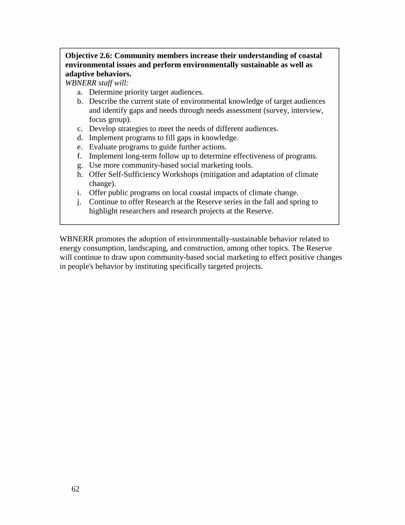
WBNERR promotes the adoption of environmentally-sustainable behavior related to energy consumption, landscaping, and construction, among other topics. The Reserve will continue to draw upon community-based social marketing to effect positive changes in people's behavior by instituting specifically targeted projects.
Objective 2.6: Community members increase their understanding of coastal environmental issues and perform environmentally sustainable as well as adaptive behaviors. WBNERR staff will:
a. Determine priority target audiences. b. Describe the current state of environmental knowledge of target audiences
and identify gaps and needs through needs assessment (survey, interview, focus group).
c. Develop strategies to meet the needs of different audiences. d. Implement programs to fill gaps in knowledge. e. Evaluate programs to guide further actions. f. Implement long-term follow up to determine effectiveness of programs. g. Use more community-based social marketing tools. h. Offer Self-Sufficiency Workshops (mitigation and adaptation of climate
change). i. Offer public programs on local coastal impacts of climate change. j. Continue to offer Research at the Reserve series in the fall and spring to
highlight researchers and research projects at the Reserve.
62

The WBNERR Education staff is responsible for training seasonal interpretive workers at the Reserve and is often involved in the training of seasonal staff at other DCR facilities, especially coastal parks. The seasonal interpretive staff training addresses interpretive techniques and program content, while providing opportunities to interface with researchers studying issues, such as coastal change and Cape Cod geology, estuarine ecology, and eutrophication. During the next five years, the Reserve will continue to place an emphasis on stewardship and will develop approaches to address identified management problems. Education staff will work with other Reserve staff members to refine the definition of target audiences and behaviors that need to be changed. For example, staff may identify trail bike impacts or the destruction of piping plover nests. Once education staff is made aware of these types of incidents, they can begin developing programs targeting specific audiences and behaviors that need to be changed. The Reserve offers a variety of interpretive programs that presently include the Junior Ranger program and Saturday Discovery Days, among other offerings. The Junior Ranger program is part of a statewide summer program for children aged eight to twelve years old. Discovery Days was instituted to bring families into the Reserve headquarters to learn about WBNERR’s research, stewardship and educational activities. Stewardship elements are incorporated into all programs, as are local coastal management issues.
Objective 2.7: Recreational users of the Reserve are increasingly aware of environmental issues and adopt environmentally-sustainable behaviors. WBNERR staff will:
a. Use community-based social marketing, training from visitor use workshop and/or Project Design and Evaluation techniques to develop interventions and test results.
b. Work with DCR to provide more emphasis on stewardship when training seasonal interpreters.
c. Work with other staff to refine the definition of target audiences and behaviors that need to be changed.
d. Continue to offer interpretive programming, along with “environmental entertainment."
e. Continue to require seasonal interpreters at the Reserve to incorporate local coastal management issues and information about environmentally-sustainable behavior into their programs.
f. Be more strategic about deploying roving interpreters. g. Offer paddle trips focusing on coastal landforms and human response to
shoreline change as DCR policies allow. h. Erect sea level rise (SLR) poles at HQ, SCB, and Washburn Island and paint
SLR lines on boat house doors. i. Add interpretive signs to headquarters and South Cape Beach to increase
environmental literacy about three main focus areas. j. Update exhibits in visitor center as funding permits, to increase environmental
literacy about three main focus areas.
63

The Reserve's seasonal interpreters are sent to areas where there are the most visitors and, not surprisingly, the most problems. The interpreters employ roving interpretation techniques to deliver stewardship messages and seek compliance with resource management policies. In addition to the Reserve's education and stewardship-oriented interpretive programs, WBNERR offers a variety of other events that are more appropriately classified as entertainment with an environmental message, such as the summer Evenings on the Bluff series. The programs feature professional entertainers who typically use song, storytelling, and/or comedy to convey information about the environment, wildlife, and the role of people as stewards of the natural world. Generally, one program each season is presented by members of the Wampanoag tribe and may include traditional song and dance, as well as a discussion of their historic and modern relationship to the estuary.
A major goal of the campus renovation, now underway, is to demonstrate sustainable resource management as a model and inspiration for visitors. Stormwater will be handled in rain gardens and vegetated swales, most surfaces will be permeable, all plantings will be “Cape friendly,” requiring few inputs of water or fertilizer once established, and composting and edible gardening will be demonstrated. In addition, a photovoltaic array will provide an estimated 50+% of campus needs and outside lighting will be energy-efficient LED.
Objective 2.8: Reserve resource management practices are used as a demonstration and teaching resource for similar coastal habitats in the region. WBNERR staff will:
a. Incorporate sustainable features into the campus renovation, including stormwater management, Cape-friendly landscaping, composting, and organic vegetable gardening.
b. Incorporate examples of resource management practices into training and education programs.
c. Include descriptions of resource management activities on the Reserve’s website and in publications.
d. Provide signage that explains the type and purpose of resource management activities being implemented.
Integrated Project #4: Interpretive Plan We have developed an Interpretive Plan for the Reserve to guide messaging and design of educational signage and exhibits. All staff had input into this plan. We will work together on implementing the Interpretive Plan by:
• Consistently referring to and incorporating the vision, goals and objectives when implementing new projects to convey our educational messages.
• Continuing to use the design developed for interpretive signage at all Reserve properties. This will help tie the different components of the Reserve together in our visitors’ minds.
64
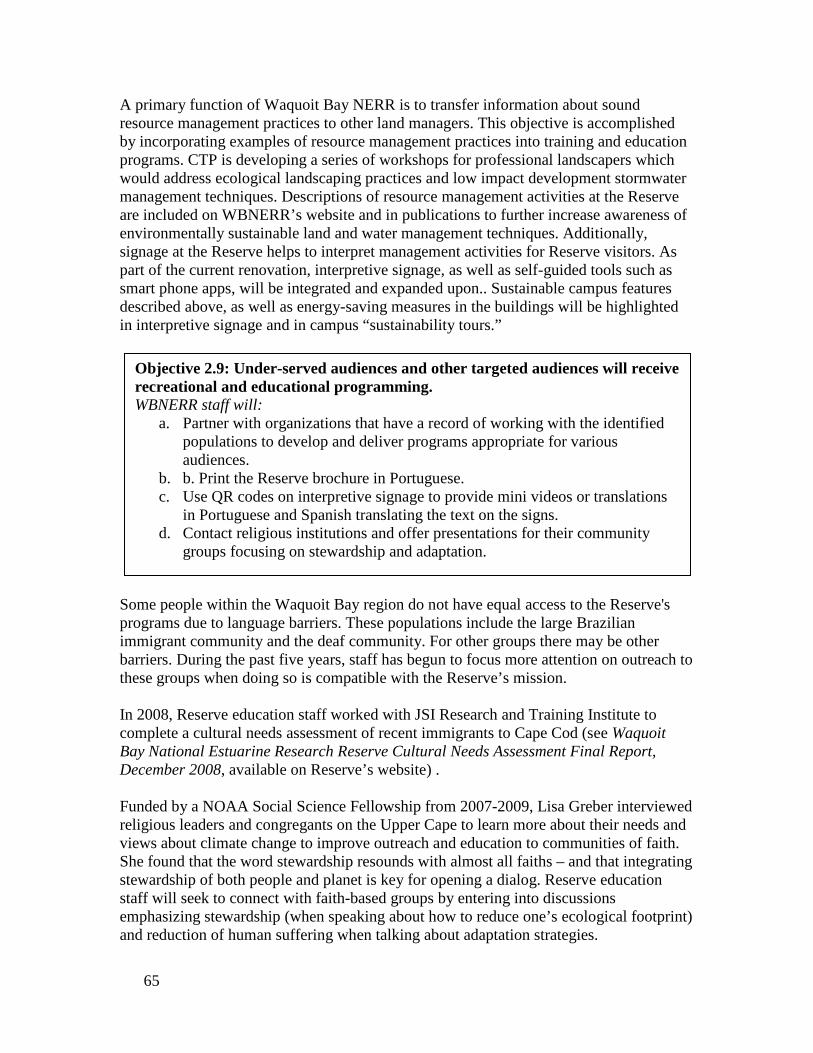
A primary function of Waquoit Bay NERR is to transfer information about sound resource management practices to other land managers. This objective is accomplished by incorporating examples of resource management practices into training and education programs. CTP is developing a series of workshops for professional landscapers which would address ecological landscaping practices and low impact development stormwater management techniques. Descriptions of resource management activities at the Reserve are included on WBNERR’s website and in publications to further increase awareness of environmentally sustainable land and water management techniques. Additionally, signage at the Reserve helps to interpret management activities for Reserve visitors. As part of the current renovation, interpretive signage, as well as self-guided tools such as smart phone apps, will be integrated and expanded upon.. Sustainable campus features described above, as well as energy-saving measures in the buildings will be highlighted in interpretive signage and in campus “sustainability tours.”
Some people within the Waquoit Bay region do not have equal access to the Reserve's programs due to language barriers. These populations include the large Brazilian immigrant community and the deaf community. For other groups there may be other barriers. During the past five years, staff has begun to focus more attention on outreach to these groups when doing so is compatible with the Reserve’s mission. In 2008, Reserve education staff worked with JSI Research and Training Institute to complete a cultural needs assessment of recent immigrants to Cape Cod (see Waquoit Bay National Estuarine Research Reserve Cultural Needs Assessment Final Report, December 2008, available on Reserve’s website) . Funded by a NOAA Social Science Fellowship from 2007-2009, Lisa Greber interviewed religious leaders and congregants on the Upper Cape to learn more about their needs and views about climate change to improve outreach and education to communities of faith. She found that the word stewardship resounds with almost all faiths – and that integrating stewardship of both people and planet is key for opening a dialog. Reserve education staff will seek to connect with faith-based groups by entering into discussions emphasizing stewardship (when speaking about how to reduce one’s ecological footprint) and reduction of human suffering when talking about adaptation strategies.
Objective 2.9: Under-served audiences and other targeted audiences will receive recreational and educational programming. WBNERR staff will:
a. Partner with organizations that have a record of working with the identified populations to develop and deliver programs appropriate for various audiences.
b. b. Print the Reserve brochure in Portuguese. c. Use QR codes on interpretive signage to provide mini videos or translations
in Portuguese and Spanish translating the text on the signs. d. Contact religious institutions and offer presentations for their community
groups focusing on stewardship and adaptation.
65

Reserve System Coastal Training Program The Coastal Training Program (CTP) provides up-to-date scientific information and skill-building opportunities to coastal decision-makers who are responsible for making decisions that affect coastal resources. Through this program, National Estuarine Research Reserves can ensure that coastal decision-makers have the knowledge and tools they need to address critical resource management issues of concern to local communities. Coastal Training Programs offered by Reserves relate to coastal habitat conservation and restoration, biodiversity, water quality and sustainable resource management and integrate Reserve-based research, monitoring and stewardship activities. Programs target a range of audiences, such as land-use planners, elected officials, regulators, land developers, community groups, environmental non-profits, business and applied scientific groups. These training programs provide opportunities for professionals to network across disciplines, and develop new collaborative relationships to solve complex environmental problems. Additionally, the CTP provides a critical feedback loop to ensure that professional audiences inform local and regional science and research agendas. Programs are developed in a variety of formats ranging from seminars, hands-on skill training, participatory workshops, lectures, and technology demonstrations. Participants benefit from opportunities to share experiences and network in a multidisciplinary setting, often with a Reserve-based field activity. Partnerships are important to the success of the program. Reserves work closely with State Coastal Programs, Sea Grant extension and education staff, and a host of local partners in determining key coastal resource issues to address, as well as the identification of target audiences. Partnerships with local agencies and organizations are critical in the exchange and sharing of expertise and resources to deliver relevant and accessible training programs that meet the needs of specific groups. The Coastal Training Program requires a systematic program development process, involving periodic review of the Reserve niche in the training provider market, audience assessments, development of a three to five year program strategy, a marketing plan and the establishment of an advisory group for guidance, program review and perspective in program development. The Coastal Training Program implements a performance monitoring system, wherein staff report data in operations progress reports according to a suite of performance indicators related to increases in participant understanding, applications of learning, and enhanced networking with peers and experts to inform programs. The Waquoit Bay Reserve Coastal Training Program The goal of the Reserve’s Coastal Training Program (CTP) is to foster better informed decision-making by local and regional coastal decision-makers to improve coastal stewardship. The CTP accomplishes this mission by serving as a link between research, policy, community support, and education. As an active member of the coastal
66

management community, the CTP Coordinator stays abreast of current scientific research and policy issues and is engaged with regional, state and community boards and organizations. The CTP Coordinator incorporates the best available science and most current and effective educational techniques into CTP programs and materials. Activities include targeted training and education that is directly responsive to the needs of the coastal management community and that provides the best available information, including cutting-edge research, project results, practical tools, and solutions to coastal management problems. The CTP also draws upon a network of experts in relevant fields as workshop presenters, further enhancing the value of these forums. The CTP is also available to provide technical assistance on a limited basis to local municipalities and provides resource and training materials to coastal decision-makers through the Reserve’s website (www.waquoitbayreserve.org). Coastal Training Programs are designed so that participating coastal decision-makers will gain the knowledge, tools and resources they need to make sustainable coastal management decisions. CTP workshops address the following topics:
• Training needs identified through informal audience needs assessments, • Training needs determined and prioritized through the formal CTP needs
assessments (e.g.., wastewater/stormwater/nitrogen loading, coastal hazards and shoreline change as well as process skills,), and
• Emerging issues identified through research at the Reserve and elsewhere that have not yet been widely recognized as having a bearing on local coastal management decisions, e.g. carbon sequestration in salt marshes and impact of nitrogen loading on this ecosystem service.
In terms of geographic coverage, the CTP serves decision-makers spread across the seventy eight (78) coastal communities in the state. These communities are grouped into five main regions: North Shore, Greater Boston, South Shore, South Coastal and Cape Cod and Islands. These regions are quite different from each other, ranging from urban and sub-urban communities in the northern areas to small towns and extensive beachfront areas with heavy recreational and tourism use in the southern and easternmost parts of the state. The CTP offers much of its programming in the Cape and Islands and South Shore regions, given its location in Falmouth, and so this sub-region is the primary geographic focus area. The Coastal Training Program is guided by an Advisory Group. Organizations and individuals represented on the group work in partnership with CTP to plan, coordinate and implement training activities and audience needs assessments. The CTP uses the combined experience and expertise of Advisory Group members and other partners to continually improve and expand the program’s offerings. The CTP Advisory Group currently consists of twelve local coastal leaders in science, management, advocacy, and education. The Advisory Group meets a few times a year, helps set CTP priorities; identifies education and training needs in coastal decision-maker groups; finds effective ways to publicize and promote coastal training opportunities; and collaborates on planning and implementation of CTP activities.
67

The CTP has been very successful in providing scientific data, practical training, and outreach materials on such varied topics as wastewater management, stormwater management, coastal landscaping using native plants, salt marsh restoration, nutrient loading and eutrophication, renewable energy use, and climate change mitigation and adaptation. The program continues to grow and have an impact at the local level.
68

Coastal Training Program Objectives
Objective 3.1 represents the core of the CTP and thus is an ongoing program objective. Plans outlined here will continue to build on what was achieved under this objective in the 2006-2011 Management Plan. The CTP uses assessments and evaluations to shape its activities and improve its ability to meet audience needs. Identifying the coastal management community's priority training needs is one of the CTP Coordinator's primary responsibilities. Toward this end, the CTP Coordinator is continually involved in informal needs assessments. The CTP Coordinator maintains open and regular dialog with the Advisory Group and other key partners in the fields of coastal management, science, education, and advocacy. Furthermore, the CTP Coordinator is an active member of the coastal management community. As such, the Coordinator is aware of the pressing needs currently facing coastal decision-makers. Additionally, the CTP Coordinator works with Reserve staff and other contacts within the scientific community to stay abreast of emerging science and
Objective 3.1: Deliver science-based knowledge and skills appropriate to the needs of coastal decision-makers in Massachusetts (particularly the Cape and Islands region) to support sustainable coastal management. WBNERR staff will:
a. Conduct informal and formal assessments of the informational and training needs of the Commonwealth’s coastal decision-makers and design targeted training events to address priority needs and barriers to effective coastal management.
b. Continue to organize and deliver a minimum of five high quality training events on priority coastal issues (water quality, climate change, land use impacts, restoration etc.) annually.
c. Incorporate ecosystem services as a new theme within CTP trainings. d. Seek to become a recognized leader in coastal training in Massachusetts. e. Organize a Coastal Conference for local officials in the Cape and Islands
region annually. f. Seek to establish a partnership with municipalities in the Cape and Islands
region in which the CTP would provide core courses for municipal staff and board members and the towns would require staff and volunteers to attend these core courses.
g. Continue to bring emerging coastal issues of significance into the spotlight locally.
h. Develop and offer a science translation workshop for scientists to support enhanced communication of scientific concepts to local decision-makers.
i. Provide post-workshop evaluations to all participants. j. Analyze evaluations and workshop discussions to assess the success of training
events and fine-tune future training efforts. k. Offer technical assistance to towns to conduct climate vulnerability
assessments and link climate adaptation planning to ongoing planning efforts.
69

technology. The CTP is responsible for drawing the attention of coastal decision-makers to these emerging issues and their implications for resource management. The CTP also undertakes formal needs assessments to help the program provide current and targeted information to coastal decision-makers. For example, the CTP has completed a formal needs assessment of local officials in the Cape and Islands region. This study, along with the revised Reserve Management Plan, is being used to guide development of a new five year strategic plan for the CTP. Future needs assessments targeting different types of decision-makers will be performed. Following a workshop or event, Reserve staff evaluates the success with which the program satisfied audience needs. The program evaluations help the CTP to provide better training programs in the future and to identify new training topics. All workshop participants are asked to complete an evaluation form that incorporates the ERD system-wide evaluation criteria at the conclusion of each workshop. WBNERR staff also makes note of significant discussion points raised during workshops. Later, Reserve staff considers workshop discussions and analyzes all evaluations to learn which aspects of the workshop were most appreciated, which could be enhanced, and what other topics or formats should be considered.
Objective 3.2: Conduct strategic planning and build partnerships to grow and increase the impact of the CTP. WBNERR staff will:
a. Coordinate and use an Advisory Group to help plan and guide activities of the CTP.
b. Develop and nurture strategic partnerships with other organizations to continue to deliver training and technical assistance to coastal decision-makers and broaden the reach of the CTP.
c. Write a new 5-year strategic plan for the CTP (as required by NOAA) using findings from 2012 needs assessment study.
d. Develop a new partnership with Oceans and Climate Institute at the Woods Hole Oceanographic Institution to develop educational materials and workshops on climate change.
e. Coordinate activities with other organizations working on climate adaptation efforts in the state of Massachusetts and establish strategic partnerships where necessary and appropriate to continue to provide effective programming in this theme.
f. Work with a suite of state, local and business partners to help launch and continue the annual coastal conference (see Objective 1) for local officials in the Cape and Islands.
g. Seek external funding to support program activities and increase staffing for CTP.
70

To strengthen the breadth and depth of CTP offerings throughout the Commonwealth, the CTP continually seeks to develop new strategic partnerships. The CTP works with partners to develop training courses and to expand the reach of its training programs through partners’ existing networks of coastal decision-makers. While CTP trainings draw participation from all across the State, the primary geographic area of emphasis for the CTP currently is the South Shore, Cape Cod, and the Islands. Within this area, CTP wants to attract more of its primary target audience (elected and appointed municipal officials, municipal staff, and board and committee members) that are charged with coastal management responsibilities. In addition the CTP intends to work with partners to expand the reach of the program into other areas of the State as time and resources allow (e.g. working with Sea Grant and CZM partners to bring developed trainings to different regions).
The CTP recognizes that volunteer boards, short-staffed municipal departments, and increasing limits on staff time and travel can constitute barriers to attending daylong workshops at Reserve Headquarters or other locations. Therefore over the next five years the CTP will seek to offer learning opportunities in different formats and venues to try and reach more of our target audience. That said, the fact that training programs bring coastal decision-makers together in the same room for a few hours is an important aspect of the CTP. Individuals have the opportunity to meet and share ideas with other people who are grappling with similar issues. This interaction may breed new partnerships or other opportunities to solve coastal problems. When appropriate, participants are also encouraged to discuss barriers they have encountered in their efforts to implement effective coastal management techniques and policies. Removal of these obstacles may then become the subject of future Reserve efforts.
Objective 3.3: Increase access of CTP target audiences to science-based information that connects to their work and help spark networking and information sharing among them. WBNERR staff will:
a. Seek to repeat a subset of training workshops in different geographic locations and at varying work and volunteer schedules to ensure that target audience members who have differing work schedules can have easier access to these events.
b. Use technology and distance learning techniques such as webinars and podcasts to bring science-based information to target audiences (e.g. launch a Climate Connections Podcast series).
c. Develop a few core short training presentations that can be delivered to local officials and municipal boards at their regular meetings.
d. Build in and offer networking opportunities at training events and seek to connect coastal decision-makers working on similar issues.
71
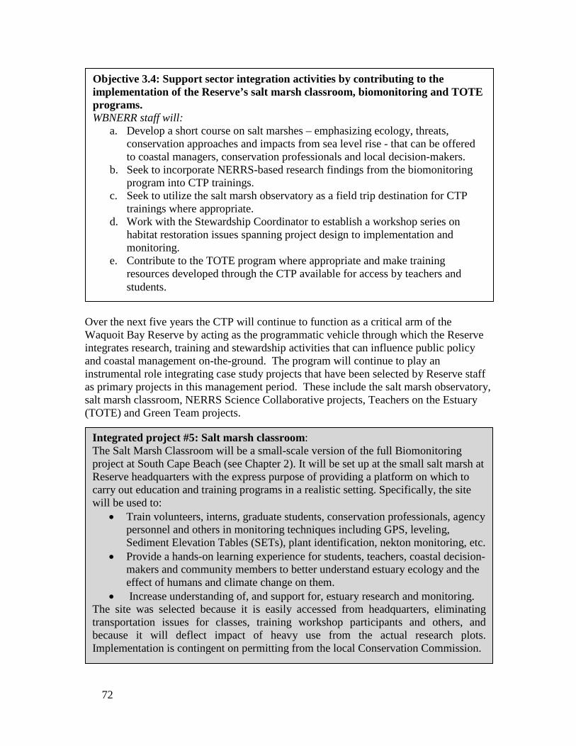
Over the next five years the CTP will continue to function as a critical arm of the Waquoit Bay Reserve by acting as the programmatic vehicle through which the Reserve integrates research, training and stewardship activities that can influence public policy and coastal management on-the-ground. The program will continue to play an instrumental role integrating case study projects that have been selected by Reserve staff as primary projects in this management period. These include the salt marsh observatory, salt marsh classroom, NERRS Science Collaborative projects, Teachers on the Estuary (TOTE) and Green Team projects.
Objective 3.4: Support sector integration activities by contributing to the implementation of the Reserve’s salt marsh classroom, biomonitoring and TOTE programs. WBNERR staff will:
a. Develop a short course on salt marshes – emphasizing ecology, threats, conservation approaches and impacts from sea level rise - that can be offered to coastal managers, conservation professionals and local decision-makers.
b. Seek to incorporate NERRS-based research findings from the biomonitoring program into CTP trainings.
c. Seek to utilize the salt marsh observatory as a field trip destination for CTP trainings where appropriate.
d. Work with the Stewardship Coordinator to establish a workshop series on habitat restoration issues spanning project design to implementation and monitoring.
e. Contribute to the TOTE program where appropriate and make training resources developed through the CTP available for access by teachers and students.
Integrated project #5: Salt marsh classroom: The Salt Marsh Classroom will be a small-scale version of the full Biomonitoring project at South Cape Beach (see Chapter 2). It will be set up at the small salt marsh at Reserve headquarters with the express purpose of providing a platform on which to carry out education and training programs in a realistic setting. Specifically, the site will be used to:
• Train volunteers, interns, graduate students, conservation professionals, agency personnel and others in monitoring techniques including GPS, leveling, Sediment Elevation Tables (SETs), plant identification, nekton monitoring, etc.
• Provide a hands-on learning experience for students, teachers, coastal decision-makers and community members to better understand estuary ecology and the effect of humans and climate change on them.
• Increase understanding of, and support for, estuary research and monitoring. The site was selected because it is easily accessed from headquarters, eliminating transportation issues for classes, training workshop participants and others, and because it will deflect impact of heavy use from the actual research plots. Implementation is contingent on permitting from the local Conservation Commission.
72
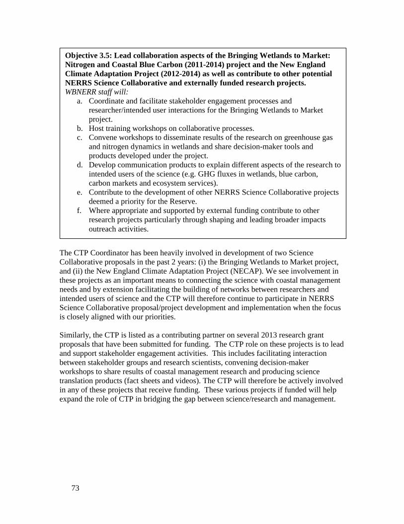
The CTP Coordinator has been heavily involved in development of two Science Collaborative proposals in the past 2 years: (i) the Bringing Wetlands to Market project, and (ii) the New England Climate Adaptation Project (NECAP). We see involvement in these projects as an important means to connecting the science with coastal management needs and by extension facilitating the building of networks between researchers and intended users of science and the CTP will therefore continue to participate in NERRS Science Collaborative proposal/project development and implementation when the focus is closely aligned with our priorities. Similarly, the CTP is listed as a contributing partner on several 2013 research grant proposals that have been submitted for funding. The CTP role on these projects is to lead and support stakeholder engagement activities. This includes facilitating interaction between stakeholder groups and research scientists, convening decision-maker workshops to share results of coastal management research and producing science translation products (fact sheets and videos). The CTP will therefore be actively involved in any of these projects that receive funding. These various projects if funded will help expand the role of CTP in bridging the gap between science/research and management.
Objective 3.5: Lead collaboration aspects of the Bringing Wetlands to Market: Nitrogen and Coastal Blue Carbon (2011-2014) project and the New England Climate Adaptation Project (2012-2014) as well as contribute to other potential NERRS Science Collaborative and externally funded research projects. WBNERR staff will:
a. Coordinate and facilitate stakeholder engagement processes and researcher/intended user interactions for the Bringing Wetlands to Market project.
b. Host training workshops on collaborative processes. c. Convene workshops to disseminate results of the research on greenhouse gas
and nitrogen dynamics in wetlands and share decision-maker tools and products developed under the project.
d. Develop communication products to explain different aspects of the research to intended users of the science (e.g. GHG fluxes in wetlands, blue carbon, carbon markets and ecosystem services).
e. Contribute to the development of other NERRS Science Collaborative projects deemed a priority for the Reserve.
f. Where appropriate and supported by external funding contribute to other research projects particularly through shaping and leading broader impacts outreach activities.
73

The Waquoit Bay CTP is also committed to playing a role in growing and expanding the national CTP program. Strengthening the national CTP ultimately has benefits for all Reserve-based CTP efforts. To this end, the CTP Coordinator will continue to actively participate in building partnerships with national organizations and contributing to NERRS CTP workgroups over the next five years.
With regard to the development of science translation products, the CTP Coordinator will seek to work with staff from other sectors (e.g. research). Acquiring additional CTP staff will be vital to meeting this objective. In addition to offering training workshops the CTP will also continue to make critical science-based information available to decision-makers in a variety of formats. The CTP will invest additional effort into translating scientific information so that decision-makers can better understand and apply this information in their work.
Objective 3.8: Appropriate professional audiences will attend WBNERR training and education events. WBNERR staff will:
a. Identify appropriate audiences for each event. b. Improve their understanding of town organizational structures on Cape Cod and
the Islands with respect to coastal management responsibilities. c. Partner with organizations representing target audiences as a way to increase
participation/attendance.
Objective 3.7: Develop science translation products for coastal decision-makers to explain priority coastal management issues and NERRS research, where appropriate. WBNERR staff will:
a. Develop a science translation product that explains key trends in water quality conditions using SWMP data.
b. Develop a product that provides an overview of the local impacts of climate change anticipated for coastal areas.
c. Develop a product that explains nitrogen-loading issues in coastal embayments and compares potential solutions to address this problem.
Objective 3.6: Help build capacity of the national CTP within the NERRS. WBNERR staff will:
a. Participate on a NERRS CTP workgroup spearheading the development and implementation of a streamlined performance monitoring system for the CTP.
b. Participate on a NERRS restoration workgroup spearheading the development of a NERRS restoration strategic action plan and restoration-based trainings.
74

Identifying and Planning Outreach to Target Audiences The quality and effectiveness of the Reserve’s training and education programs partially depends on appropriately identifying the audiences we serve and their information needs so that programs can be tailored to be meaningful and applicable to target groups. Based on this recognition, WBNERR staff gives careful attention to the identification of appropriate audiences when they are planning training and education events, particularly when a new subject is the focus of the event. Information about who should be invited to events is gathered through networking and by contacting professional organizations. Announcements are then targeted toward appropriate professional audiences. For instance, educators receive e-mails about teacher training opportunities. Contact information for a variety of audiences is maintained within the Reserve's database (refer to Objective 5.11.h). This information is used to target direct mailings and is updated on an ongoing basis. Reaching out to members of volunteer boards and commissions, such as local elected and appointed officials, is a more challenging issue. Membership changes regularly, members typically have other jobs and responsibilities during the day, and the most direct communication channels are not always apparent. Despite the inherent difficulty in reaching this audience, it is imperative that the Coastal Training Program do so effectively. As such continually assessing audience needs and staying abreast of issues that affect our target audiences as well as how these groups change and evolve over time is an important “behind the scenes” activity of the CTP and education programs. Local municipal boards and committees and other similar entities are charged with making decisions that, directly or indirectly, impact the health of the Commonwealth’s coasts. Furthermore, members of volunteer boards do not always have access to the science-based information need to make the most informed decisions about coastal issues. The number and variety of boards is likely to be different from town to town and, also, the responsibilities of particular departments (e.g., Health) are likely to vary, as well. WBNERR will, therefore, identify relevant town departments, commissions and committees on Cape Cod, their responsibilities, and their membership. A mailing list of town officials and board members has been incorporated within the Reserve's database and is updated regularly so that CTP events can be strategically promoted. To further increase participation in WBNERR events, Reserve staff will continue to build and nurture partnerships with organizations representing target audiences, to enable the program to be more effective at establishing links with target groups. In addition to programs directed toward key decision-maker audiences, the Reserve delivers numerous education and interpretive programs to the general public. Events include workshops on Ecological landscaping, Evenings on the Bluff, and interpretive walks. These types of events are advertised through the newsletter, website, news releases, e-mail blasts, Constant Contact, and other mechanisms. Seasonal staff promotes upcoming events during their interpretive walks. Events are also promoted by partner organizations such as the Waquoit Bay Reserve Foundation.
75

Leveraging Training and Education Activities
As part of CTP’s support to coastal decision-makers after they have participated in a training event—and to provide information to coastal decision-makers who were not able to attend—workshop materials, presentations, and reference materials are made available on the WBNERR website (www.waquoitbayreserve.org). Over time, the online “library” of information relating to WBNERR's priority topics has grown and will continue to grow and remain readily available. Other materials now being posted include workshop agendas, proceedings, contact information for presenters and video recordings of selected workshops. As described under Objective 3.1.a, workshop participants may be asked to identify obstacles to implementation of sustainable coastal management practices highlighted in the training. WBNERR can then use this information to guide its own research and to take an active role in barrier removal. For instance, professional landscapers who resisted the use of native plants in landscaping (to reduce nitrogen loading) are obstacles to homeowners’ use of these plants. The Reserve staff, therefore, targeted landscapers for training. This effort identified another obstacle: the lack of availability and knowledge of native plants by the nurseries.
As noted in Objective 3.3.d, networking opportunities are incorporated into CTP training events. The CTP also fosters networking by coordinating roundtable discussions between decision-makers and scientists. The discussions address coastal management issues. Participants bring the perspective of their profession and learn how individuals from other fields perceive and address the particular topic under discussion. This helps raise the awareness of the researchers about coastal management information needs and helps the coastal decision-makers understand the culture of science which has a different time-frame and need for accuracy. It provides a mechanism for these groups, both important contributors to coastal management, to question and learn from each other directly. Often
Objective 3.9: Workshops and other training activities will be the springboard for further support to coastal decision-makers. WBNERR staff will:
a. Provide organized workshop follow-up, including the placement of workshop agendas, presentations, proceedings, reference material, and contact information for presenters on the WBNERR and CTP websites.
b. Implement measures where possible to address barriers to effective coastal management as identified under Objective 3.1.a.
c. Look for ways to sustain the involvement of audience members through the formation of working groups or committees that would continue implementation of workshop outcomes.
d. Bring coastal decision-makers and scientists together for focused round-table discussions on specific issues.
e. Act as referral service connecting coastal decision-makers and community groups with relevant information and contacts.
76

the managers can learn information important to coastal management from the scientists prior to its publication in papers. Since establishment of the Waquoit Bay Reserve CTP in 2002 the program has blossomed to become a primary provider of education on coastal issues to professional audiences, local and regional decision-makers, environmental non-profits and volunteer municipal boards in southeastern MA. A large part of the vision for the CTP over the next five years involves working to expand the reach of the program and having an even greater impact on the primary target audience for decision-makers the program serves. Given that the primary audience for the CTP - i.e. local and regional officials, municipal staff and volunteer boards - deal with multiple issues and are often challenged by resource and time limitations, reaching more of this target group necessitates that the CTP increase staffing. The CTP is currently staffed by a full-time Coordinator and the Events Coordinator provides logistical and planning support for training events. While CTP workshops currently attract large audiences and are often over-subscribed, the CTP Coordinator recognizes that positioning the program to continue on an upward path will require using different approaches. These will involve having more of a presence in the towns we serve, doing more face-to-face time with the target group, coordinating directly with towns to hold training programs and ultimately taking more training to towns rather than having town officials come to training at different locations. To support the achievement of these goals and pending availability of funding, the Reserve envisions securing two Coastal Training Program Assistants (see also Future Staffing Plan, p. 113). These positions would enable the CTP to meet the demands of a growing program as well as growing information needs within our target audience. While the CTP works with partners where possible and necessary and is continually building partnership networks, the acquisition of additional staff is crucial in this Management Plan period as it will largely dictate whether the Reserve can truly expand its training offerings in the ways desired. Other Community Engagement Education and Training activities will ultimately be judged successful if they motivate local communities to increasingly take responsibility for the development of solutions to coastal ecosystem management issues. WBNERR's role in this context is to foster community action that is consistent with—and may even shape—local, state and federal coastal management priorities. Toward this end, WBNERR remains engaged with community organizations and entities around coastal issues.
77

Ultimately, local communities must take initiative and provide leadership for managing coastal resources. In some cases, Reserve staff directly participate on local or regional committees and boards that deal with coastal management issues, such as the Falmouth Coastal Management Committee, Falmouth Associations Concerned with Estuaries and Salt Ponds, the 300 Committee Land Trust, and others. When it is keeping with the Reserve’s mission and assuming resources are available, staff will respond to requests for support from towns and community groups. This support includes the identification and provision of project-specific, science-based information, training activities, and one-to-one consultation, especially if it is determined that such help will launch sustainable projects. The Reserve communicates the availability of this type of information and support to local towns and community groups.
Objective 3.10: Support local communities working to protect coastal resources and develop and implement coastal management solutions WBNERR staff will:
a. Participate in community efforts that further the Reserve’s mission and objectives.
b. Serve on regional and local committees and boards relevant to coastal management where possible.
c. Respond to requests for assistance from local coastal decision-makers and municipalities and provide technical assistance when possible and appropriate to the Reserve’s mission.
78

Land Management at Waquoit Bay NERR Priorities include:
• Balancing land protection with recreational and educational needs • Restoring ecosystem function to degraded habitats • Enhancing ecosystem diversity and resiliency through management • Locating and designing restoration and management projects to provide interpretive and
educational opportunities • Applying and testing innovative management techniques
Land Management in the NERRS: Priorities include:
• Better protection and management of estuaries and coastal watersheds by implementing place-based approaches at reserves. (from the NERRS 2011-2016 Strategic Plan)
Goals and Objectives:
• Increase permanent protection and restoration of key areas in reserve watersheds to improve coastal habitat quantity, quality, and resiliency to climate change impacts.
• Develop, demonstrate, and evaluate tools and practices at Reserves that advance progress on habitat protection, water quality, and climate change impacts.
• Expand biogeographic representation of the nation’s estuaries in the Reserve system by designating new reserves.
Chapter 4: Practicing What We Preach: Land and Facilities Management
Goal 4: Manage land and facilities in a manner that balances enjoyment by current generations with conservation for the future. Overview This chapter describes WBNERR’s management of and plans for its lands and facilities. The Reserve aims to provide an enjoyable and educational experience for visitors while balancing the need to protect resources for the future. We protect the land and water resources of the Waquoit Bay watershed through land management activities, restoration practices, and management of public access. In areas where we encourage public access, we will be focusing on improving facilities, signage, and trails. These activities, represented by Objectives 4.1 through 4.6 generally fall under the purview of the Stewardship Program and Facilities Supervisor. Land Management Waquoit Bay Reserve’s Land Management Objectives
79

WBNERR staff must routinely balance the need for resource protection with the public's recreational use of Reserve property. The Reserve’s Public Access Plan (Appendix I) helps guide use by visitors of the various land holdings. The Stewardship Coordinator and Forests and Parks Supervisor work closely together to define and implement the most appropriate land management practices. WBNERR staff will work with DCR and Town Committees to develop and implement resource Management Plans for several key resources at the Reserve that warrant specific consideration. Examples include rare sand plain grassland communities, anadromous fish, New England cottontail, and habitats indentified by the vulnerability assessment to be at risk. To clearly identify areas where the public are and are not allowed, WBNERR staff will ensure that trails, roads, boardwalks, symbolic fencing and campsites are well marked and maintained. New hiking trails are developed periodically. Staff is mindful of potential user impacts and designs trails to minimize impacts to the greatest extent possible. Improvements to trails to enhance visitor enjoyment and educational opportunities continue. In summer 2011, a Student Conservation Association crew built two viewing platforms on trails at South Cape Beach overlooking fresh- and saltwater marshes. Interpretive signage will be added this year. We plan to build two viewing platforms at Headquarters overlooking the bay and salt marsh if Conservation Commission approval is obtained. We also plan to extend one of the trails on campus, and build a boardwalk over the salt marsh to provide access for educational programs as part of the Salt Marsh Classroom project, again pending Conservation Commission approval.
Objective 4.1: Reserve lands are effectively managed with an emphasis on conservation and sustainable uses of ecological resources while balancing the needs of research, education and recreation. WBNERR staff will:
a. Manage land-based resources for sustainability of ecological function, research, education and recreational uses.
b. Provide improved experience for recreational visitors by providing better access, targeted resource interpretation, and new recreational opportunities on Reserve Components when compatible with land protection and research goals.
c. Manage lands with an emphasis on providing habitat types or conditions that cannot be met on private or public lands in the watershed. This may be larger blocks of interior forest, conditions to support rare or threatened species, or unique communities.
d. Monitor and manage lands for species protected under the Federal Endangered Species Act and the Massachusetts Endangered Species Act.
e. Continue to make information about regulations, Reserve policies, and appropriate behaviors readily available to users through signs, written materials, and staff.
f. Improve trail signs and markers. g. Continue to protect cultural resources
80

The cultural resources of WBNERR, including archaeological remains and significant historic buildings, are finite resources. In order to protect these resources, Reserve staff consider and minimize the potential effects of projects—both capital and everyday operations—on historic and archaeological resources. An example of a plan targeted at a specific resource is the Washburn Island Prescribed Fire Plan that was completed in 2012. The plan includes a strong emphasis on ecological restoration of fire dependent sand plain grasslands and the rare plants that they support. Controlled burns are conducted on Washburn Island for three reasons: to maintain a fire-dependent sand plain community; to maintain low forest fuel and, thereby, prevent a catastrophic fire; and to serve as a training site for fire response crews Due to limited staff time and resources, the Reserve restricts its invasive species management program to removing species from critical areas such as areas where invasive species compete with rare plants and monitoring invasive species extents when volunteers are available. We have included Phragmites and its response to climate change stressors as one of the habitat types that we are monitoring in our habitat change analysis. Staff will continue to work with partners on the Mashpee National Wildlife Refuge Conservation Partnership to manage road and trail access. The Reserve will work with the Town of Mashpee to develop management strategies for South Cape Beach. This is one of the Integrated Projects the Reserve is undertaking.
Integrated Project #6: South Cape Beach Management Strategies The South Cape Beach component of the Reserve sees the most use in terms of both numbers of visitors and types of usage. Risk of personal injury and resource degradation increase as usage grows. Development of a set of management strategies will lay out a deliberate way forward that maximizes opportunities for public enjoyment and education while minimizing damage to habitat, wildlife, and research areas. The strategies will include:
• An access plan for roads, trails, and paths. For example: Wills Work Rd. access, including possibly a stakeholder
engagement process and re-thinking contact station location on entry road
Funneling people into distinct, intentional paths rather than multiple ones across dunes
Enhancing Flat Pond Trail • Interpretive planning and signage – capitalizing on high visitor numbers
to reach people with our message • Identifying research areas - how to manage with visitors and how to
highlight with educational signage • Shorebird protection – conflicts with other users and opportunities for
education • Facility improvements for recreation and other users • Completion of a vulnerability assessment
81

Protected Species Management The Reserve currently has an active program for monitoring and managing protected species and their habitats. For example, competing plants are mowed or burned in order to allow rare plants to flourish. Shorebirds are protected by closing areas to human activities and by artificially protecting nests from natural predation. Finally, due to the maturation of forest lands within the Reserve, increasing impacts from changes in local and regional climate and sea level rise, the Reserve plans to undertake an ecological vulnerability assessment. This assessment is intended to identify habitats and communities that are most at risk from predicted changes in climate and sea level rise and to identify management, protection and restoration strategies to mitigate these risks. Threatened Shorebirds There are two species of concern on Reserve property; the piping plover and the least tern. The Federal government lists the piping plover as a threatened species. Piping plovers presently nest in limited numbers on South Cape Beach and the beach at the southern end of Washburn Island. Because their eggs are laid on the ground and are well camouflaged, they are often accidentally damaged or destroyed by human actions. Nests on the ground also make the eggs easily accessible to predators. The Reserve’s Seasonal Shorebird Manager works in cooperation with the Massachusetts Department of Fisheries, Wildlife and Environmental Law Enforcement (DFWELE) and the Massachusetts Audubon Society. The Reserve trains volunteers to 1) recognize signs of mating and nesting activity and 2) to erect predator exclusion fences to protect eggs and hatchlings. Volunteers inform beach-goers about risks to the birds’ nests and chicks from dogs, flying kites, and other human activities on the beach.
Least terns (Sterna antillarum), a state species of special concern, are present at South Cape Beach and have historically nested there. Roseate terns, common terns, willets, and American oyster catchers also feed at South Cape Beach and may nest there as well. All five species are monitored under a contract with Massachusetts Audobon. Regulations Applicable rules and regulations are posted throughout Reserve lands and described in literature available at Reserve facilities and from Reserve staff (Appendix F). When appropriate, all WBNERR staff educates Reserve visitors about rules and regulations and appropriate behaviors and activities. In particular, the Island Managers and the Shorebird Manager are trained and are responsible for educating visitors to the heavily used Washburn Island and South Cape Beach areas of the Reserve, respectively. Existing signage throughout the Reserve will be enhanced better trail signs that depict the trails and, where appropriate, include additional information about such things as key ecological resources, actions individuals can take (or avoid) to protect natural resources, and the Reserve's mission to improve stewardship of the region's estuarine and coastal watershed ecosystems.
82

WBNERR resources are affected by activities on all watershed lands and adjacent waters, including areas not owned by the Reserve. Groundwater and rivers from portions of Falmouth, Mashpee and Sandwich interconnect throughout the watershed and eventually with the Bay. As such, all watershed residents and decision-makers have the ability to affect the quality of the Waquoit Bay ecosystem for better or worse. The Reserve works to direct these people toward behaviors and projects that make them "good" watershed stewards and minimize their impacts on the Reserve’s resources. Toward this end, Reserve staff track, investigate, and comment on proposed developments and activities that could potentially impact watershed resources and, therefore, Waquoit Bay. In addition staff review and comment on regulatory and policy initiatives and changes that affect the Reserve’s, DCR’s and NOAA’s interests. The Reserve takes such public comments very seriously and insists that decision-makers seriously consider the Reserve's viewpoint in light of the regional, state and national significance of the Waquoit Bay ecosystem. The Mashpee National Wildlife Refuge conservation partnership, involving eight local, state, Federal, tribal, and non-profit agencies, was established in order to coordinate land protection efforts within the Waquoit Bay watershed (see Objective 4.2.c. p. 88 and Objective 5.5 p. 108). WBNERR staff has been instrumental in leading the group’s conservation and Management Planning efforts. The Reserve also provides meeting space. WBNERR staff will continue to be actively involved and will take a leadership role as necessary.
Objective 4.2: Decisions about the management of non-Reserve land in the Waquoit Bay watershed are beneficial to—or at least minimize impacts to—the Waquoit Bay ecosystem. WBNERR staff will:
a. Monitor, research and comment on proposed developments and activities with potential to affect Reserve resources.
b. Review and comment on reports, regulations, by-laws, and policies that affect the Reserve.
c. Participate in and, where appropriate, provide leadership in the MNWR land conservation partnership.
83

Ecological Restoration Activities
Habitat restoration at WBNERR is intended to improve the ecological integrity and biogeographical representative character of the Reserve, provide additional habitat for threatened and endangered species, and address information gaps in the science of habitat restoration. The Waquoit Bay watershed, like most coastal areas in the Northeast U.S., has a long history of human alteration. Even the lands and waters that are now protected within the Reserve and appear “natural” have been altered from their pre-colonial condition and may not be providing the full ecological functions that they once did (or could). Restoration planning on the Reserve falls into three major areas for this planning period. These are river restoration projects, sand plain grassland restoration, and forest restoration. River Restoration Master Plan Through a grant from MCZM, WBNERR hired a consultant to develop a River Restoration Master Plan for the seven tributary streams into Waquoit Bay. Rather than looking at the rivers, and even impediments, on an individual basis, we used a watershed approach to identify and prioritize potential restoration projects so that we would be ready when construction funding becomes available. Project partners who brought their knowledge and expertise to the table included US FWS, MA Fish and Wildlife, Mashpee Wampanoag Tribe, MA DMF, Trout Unlimited, and natural resource agents from Falmouth and Mashpee. The result is a comprehensive document that describes impediments to fish passage and other habitat degradation along the streams. Four projects aimed at mitigating these problems were deemed to have overall greater potential, from the standpoints of both construction feasibility and education/research potential. The Plan provides conceptual designs and cost estimates for implementation of three of these projects, and a narrative description of further information needed for the fourth. WBNERR intends to work toward carrying out these projects over the years as funding is available. Projects include:
Objective 4.3: Ecological function is enhanced on rare or critical habitats on the Reserve or within the watershed. WBNERR staff will:
a. Work to implement the recently completed Waquoit Bay River Restoration Master Plan by completing the two highest priority projects (Childs River fish passage, and Quashnet River bog restoration)
b. Carry out prescribed fires in the Washburn Island and Headquarters coastal sand plain grassland communities to maintain this rare habitat type
c. Work with the Mashpee National Wildlife Refuge Partners to identify and manage key habitats for New England Cottontails on Reserve and adjacent protected properties.
84

• Removal of sediment and remaining boards blocking stream flow at the old “fishway” in the middle section of the Quashnet River. This may include closing the road crossing in this location dependent on partner approvals (Mashpee Fire Chief).
• A partial breach and nature-like fishway at the Carriage Shop Dam on the Childs River.
• A stream and forested wetland restoration within the footprint of abandoned cranberry bogs on the upper Quashnet River, now owned by the Town of Mashpee.
• Removal of a culvert on Abigail Brook. • A series of former cranberry bog earthen embankments/impoundments with various
control structures on the middle reach of the Quashnet.
The projects identified here as part of the Master Planning process include a variety of habitat types to be restored, restoration methods, ownership, and geographic distribution within the watershed.
Coastal Sandplain Grassland The Reserve contains several small areas of remnant coastal sandplain grassland. This once common natural community is now rare because it has been replaced by coastal development or the wildfire disturbances that once maintained it are now arrested. The Reserve uses mechanical methods and prescribed fire to control natural succession and restore sandplain grassland habitat on Washburn Island and at the headquarters site. These activities promote the rare natural community and species that comprise it, including Agalinis acuta (sandplain gerardia) and Liatris borealis (New England blazing star). Agalinis is on the Federal endangered species list and Liatris is a state-listed plant of special concern.
Forest Restoration Several areas on the Reserve have been identified as critical habitat for New England Cottontail. This species is a candidate for listing under the Federal Endangered Species Act. During 2010-2012 the Reserve has worked with its conservation partners in the Mashpee National Wildlife Refuge to identify populations of New England cottontails, track their movements with radio collars, conduct habitat analysis and conduct genetic work to estimate population sizes and patch connectivity. During the period of this plan the Reserve anticipates undertaking applications of mechanical treatments and application of prescribed fire to enhance or increase New England cottontail habitat on Reserve properties. Land Acquisition
Objective 4.4: DCR will acquire real estate rights to key parcels in the Waquoit Bay Watershed area to expand the Reserve. WBNERR staff will:
a. Work with MNWR partners to prioritize land for acquisition. b. Seek funds for land acquisition from willing sellers. c. Work closely with DCR land acquisition staff on land acquisition process.
85

Research at WBNERR has shown that land use change, particularly residential development, in the Waquoit Bay watershed has resulted in drastic impacts to estuarine resources. A key component of WBNERR’s efforts to protect the quality of the land and water ecosystems within the Reserve is working with willing sellers to preserve undeveloped land in and around the Waquoit Bay watershed (Figure 10). Land acquisition by the Reserve provides increased opportunities for research and education activities. Such protection of undeveloped land also provides many tangential benefits to coastal communities in the form of aesthetic values, controlled recreational access, limitations to increases in traffic, and protection of drinking water resources, and mitigation of nitrogen. Land acquisition activities are implemented with guidance from its Land Acquisition Plan (Appendix J) and in conjunction with its participation in the Mashpee National Wildlife Refuge Conservation Partnership. In addition, with recent emphasis on Climate Change, the reserve is taking a new look at its landholdings for their carbon sequestration potential. Analysis by a greenhouse gas intern in summer 2012 demonstrated that Reserve lands conserved in their natural state store over 8200 tons of carbon annually.
86

Figure 10: Protected areas in the Waquoit Bay Watershed
87

Facilities, Grounds and Equipment
The Reserve's Forest and Park Supervisor oversees the regular maintenance of all buildings, vehicles, vessels, and other non-research equipment. To the extent possible given staffing limitations, these assets are kept clean and in good working order. The care with which the Reserve maintains its assets prolongs the useful life of the structures and equipment. It also helps to convey to visitors that they have entered a special place: one that is valued and cared for. Toward this end, all maintenance activities are carried out in a professional manner. Sustainability The Reserve demonstrates environmentally-sustainable operations through its selection of products and adoption of best management practices. A number of energy-saving measures have been undertaken in the last few years, many resulting from Green Team suggestions (see also box on p. 93). Waquoit Bay Reserve is one of three pilot DCR Green Teams formed in response to the Governor’s Leading By Example Executive Order which directs state entities to substantially reduce greenhouse gas emissions over the next few years (Executive Order 484). In 2008, the whole staff committed to DCR’s “10 Steps to a Successful Green Team” and brainstormed ways the Reserve could improve its practices. An intern from Massachusetts Maritime Academy collected baseline energy use and created an Energy Tracker spreadsheet to automatically display the data in easy to compare graphs. Another intern updated the data base in 2012 and compared energy usage over time. The Reserve applied for and was awarded a Leading by Example grant to install boiler managers on their oil burners (these have a very quick pay back), have a complete, professional energy audit done on the Main House, and complete energy measures recommended for the Gate House and Boat House. Since energy efficiency is the most cost effective way to reduce emissions, numerous building envelope and insulation measures were undertaken in Reserve buildings, including high R-value insulation in the Visitor Center installed at no cost to the Reserve by Cape Light Compact. All incandescent light bulbs have been replaced with LEDs. Programmable thermostats and
Objective 4.5: Reserve structures and equipment will be maintained in a safe, clean manner that is mindful of the environmental and cultural values of the site. WBNERR staff will:
a. Ensure, to the greatest extent possible, that all buildings, vehicles, vessels, and other equipment are safe for their designated uses.
b. Ensure that WBNERR facilities are cleaned to publicly acceptable standards. c. Use environmentally-sensitive products and practices to the greatest extent
possible/practical including ensuring that invasive species are not introduced or spread through management actions.
d. Design improvements or modifications to the Sargent Estate, including its buildings and grounds, in accordance with the Secretary of the Interior’s Standards and Guidelines for Historic Preservation Projects.
88

motion-lights are also in use in all buildings. Energy Star-rated appliances have replaced old ones in the Gate House dormitory. The last two remaining old, inefficient oil furnaces have recently been replaced with high-efficiency gas burners. Staff contributes to reducing energy use by turning off lights, computers, fans and copiers when not in use, reusing scrap paper, composting food scraps, and combining vehicle trips. As a result of these measures, building energy usage at the Reserve has decreased over 36% from 2002 to 2012 (58% when Degree Days are not taken into account).We expect this number to fall further as the new oil burners were not installed until late in the winter of 2012, so only a few months with the new gas furnaces is included in this analysis. In addition to these completed and ongoing measures, the construction (PAC) award from NOAA and DCR will fund the installation of approximately 19 kW of photovoltaic panels, LED exterior lighting, and new, energy efficient windows in the mansion, all of which should further contribute to energy and cost reductions. Figure 11: Reserve building energy usage over time
Other actions by the Green Team include starting up a demonstration compost pile and organic vegetable garden to reduce chemical fertilizer and emissions from transportation of food. In 2012 an intern completed a Greenhouse Gas (GHG) Analysis of the Reserve. He looked not only at emissions produced through operations, but also at carbon sequestered in the 1300 acres of land we manage. Results of the analysis showed a 36% reduction in GHG production (this analysis included staff commutes and Reserve vehicle use). Surprisingly, staff commutes were highest or second highest contributor, above building heating or electricity. It also showed that we sequester 8200 tons of carbon each year. This shows the vital role that land conservation plays in combating global warming. During this time the Reserve has also continued to offer workshops to community members on topics such as energy efficiency, renewable energy, organic vegetable gardening and the Buy Fresh, Buy Local program. We also hosted a hands-on weatherization workshop to train people for the Community Corps weatherization
0
20
40
60
80
100
120
140
160
FY2002 FY2008 FY2009 FY2010 FY2011 FY2012
Btu/
HDD
(x 1
000)
Total BTUs per Degree Day
89
program (a CIRenew project meant to lower fuel use and expenses for low income residents). The Reserve Manager has partnered with a scientist from the Woods Hole Research Center to give a joint talk entitled, “Losing Cape Cod: Sea Level, Salt Marshes, Wastewater, Land Use & Climate Change” for numerous community groups describing conversion of land from forest to development on Cape Cod, potential impacts of sea level rise, the Greenhouse Gas Analysis and Bringing Wetlands to Market Science Collaborative Project, all of which emphasize the importance of energy conservation and land preservation to combat climate change. She gave this talk to the DCR Supervisors Academy in April, a gathering of all the MA state park supervisors. The Reserve will continue—and, where possible, will expand—these energy saving and outreach measures into the future. The state has recently implemented an Energy Tracker system for all state facilities. WBNERR will continue to monitor energy use using this tool.
Because the Reserve’s headquarters are within the Waquoit National Historic District, any modifications to the buildings or grounds will be conducted in accordance with accepted standards for historic preservation.
Problems identified in past management plans included poor placement of Maintenance in the center of campus, inadequate and outdated facilities for all programs including Research and Education, an unwelcoming and unclear entrance and campus layout, outdated Visitor Center exhibits, lack of a research dock, and unsafe beach access. Due to funding constraints, addressing these issues will need to be carried out in phases.
Objective 4.6: The Reserve will continue to explore option to improve operations and renovations to support research, education, and training programs. WBNERR staff will:
a. Work to care for the historic building and grounds and identify projects to increase program efficiency or service to our many visitors. This includes the possible construction of a dock and improvements to the visitor center.
Integrated Project #7: Green Team The Team, on which all staff participates, seeks to continually look for ways to reduce the use of resources at the Reserve. Many of the energy-saving actions described above resulted from Green Team assessments and suggestions. The Reserve is committed to do more to model sustainable practices that we educate others about and that we know will ultimately help to protect coastal environments. The recently completed Greenhouse Gas analysis of the Reserve will help guide future direction for energy reduction. The interpretive signage for the campus redesign funded through PAC draws attention to sustainable features on campus.
90

The first phase, funded by 2011 PAC, involved construction of a new maintenance garage at the periphery of the campus; modest renovation of the Carriage House space vacated by Maintenance to enhance space and capacity for Research and Education; and, improvements to the headquarters entrance, parking, grounds, and exhibits to create a more welcoming, interesting and engaging pedestrian campus. It also includes a research dock. 2012 PAC funds enabled installation of approximately 19 kW of photovoltaic panels, and will also fund new LED lighting for the campus. An expanded maintenance shop that can accommodate the Reserve's larger vessels provides indoor space in which to scrape and paint hulls or maintain outboard motors (Reserve staff maintains four boats) and perform winter maintenance and the attachment and removal of plows on trucks. Re-locating Maintenance to the periphery of the campus behind the Gate House dormitory also serves to remove dumpsters, boat trailers, lumber, and other miscellaneous and unsightly equipment from the center of campus, where it is currently the first thing a visitor sees. It also addresses the public safety issue created when children are dropped off for classes in the Carriage House while equipment and trucks are being driven around the area by maintenance staff. An improved entrance that is wider and better marked (with a new entrance sign) and lit serves to draw more visitors in. Once the visitor enters, relocated parking has created more of a pedestrian campus. An improved viewscape toward the Bay and Visitor Center lets the visitor view the destination. A kiosk, also visible on the way to the parking area, draws people toward the visitor center once they are out of their cars. It serves to orient the visitor to the Reserve – who we are, what we do, where the buildings are, etc. More interpretive signage enhances the outdoor experience, and informs people about our mission. A fixed or floating dock in front of the Boat House will serve as an access way to vessels and as a research platform. Currently, both in-house and visiting researchers have to maneuver a dinghy from the beach into the water, row out to their moored boats, attach the dinghy to the boat, and bring the boat and dinghy to the shore to pull the dinghy on the beach again. These steps are necessary before the researchers can start loading their equipment into the boats. A dock would be a much more efficient way to access the boats and load equipment so that researchers can get to their research sites more quickly. The dock will also serve as a research platform from which scientific instruments are suspended or are otherwise attached. Gaining regulatory approval for such a dock may be difficult. As noted in Appendix E, new private docks and piers are prohibited within an Area of Environmental Concern (ACEC) without an approved resource Management Plan (there is no such plan for the Waquoit Bay ACEC).). Other phases of the Vision Plan, for which future funding could be sought, include renovation of the Carriage House into two larger, more modern classrooms, dedicated bench space for outside researchers, and updating visitor center exhibits. modern exhibits .
91

Chapter 5: Improving Operations and Stature
Goal 5: Improve the operations and stature of the Reserve. The administration of the Waquoit Bay National Estuarine Research Reserve supports and enables the implementation of the Reserve’s principal functions: research and monitoring, education and training, and stewardship. The term "administration" is used here to include Reserve activities in response to agency mandates and in accordance with agency procedures. Administration includes support of employees and volunteers, and the adoption and support of appropriate computer technologies. Administration also includes the Reserve's efforts to publicize its activities to a variety of audiences. This chapter is divided into sections to address these topics: Management Environment; Staffing; Technology; and Communications Plan. Taken together, these sections form the Reserve's Administrative Plan. Management Objectives Self-Evaluation
The operation of the Reserve will be guided by this document, Waquoit Bay National Estuarine Research Reserve Management Plan 2014-2019. Staff will monitor and evaluate implementation of the Management Plan to ensure that all requirements are met and all guidelines (e.g., Land Stewardship Zoning Guidelines) are incorporated into management decisions. Furthermore, to enable staff to assess progress toward program
Objective 5.1: WBNERR will develop an internal strategic performance monitoring process that will enable timely strategic assessment of program results. WBNERR staff will:
a. Monitor and evaluate implementation of the Management Plan to ensure all guidelines and requirements are met.
b. Meet annually to review progress toward achieving goals, objectives and selected, measurable milestones in the Management Plan. Review and change milestones as needed.
92

goals and objectives, a performance monitoring plan that details key results and indicators to be measured under each goal and selected objective will be generated each year. Toward this end, staff will generate annual work plans for the upcoming year based on this Management Plan. Select activities and milestones from each person’s annual work plan will be incorporated into the performance monitoring plan. The staff will meet annually, during the winter, to review progress toward completing action items in support of achieving the objectives described in this Management Plan. This annual performance review will allow staff an opportunity to reflect upon what has worked well (or not so well) in the past and to incorporate that knowledge into future work plans. Many of the objectives and action items described in this Management Plan are not easily quantifiable, particularly those that deal with changing attitudes and behavior. As such, while progress toward the achievement of all objectives will be examined, only progress toward selected, measurable milestones will be documented initially. At the same time, a mid-year assessment will be made of progress toward meeting the new 312 Evaluation metrics (Figure 12) Performance monitoring will be an iterative process.
93
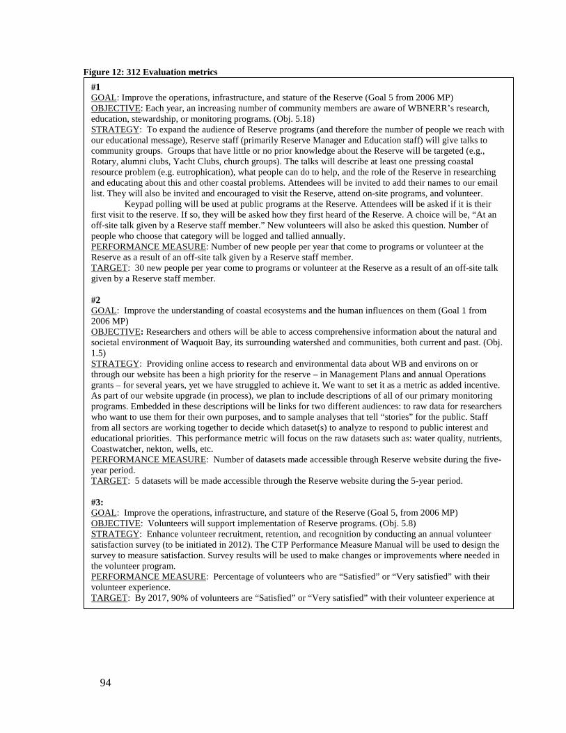
Figure 12: 312 Evaluation metrics
#1 GOAL: Improve the operations, infrastructure, and stature of the Reserve (Goal 5 from 2006 MP) OBJECTIVE: Each year, an increasing number of community members are aware of WBNERR’s research, education, stewardship, or monitoring programs. (Obj. 5.18) STRATEGY: To expand the audience of Reserve programs (and therefore the number of people we reach with our educational message), Reserve staff (primarily Reserve Manager and Education staff) will give talks to community groups. Groups that have little or no prior knowledge about the Reserve will be targeted (e.g., Rotary, alumni clubs, Yacht Clubs, church groups). The talks will describe at least one pressing coastal resource problem (e.g. eutrophication), what people can do to help, and the role of the Reserve in researching and educating about this and other coastal problems. Attendees will be invited to add their names to our email list. They will also be invited and encouraged to visit the Reserve, attend on-site programs, and volunteer.
Keypad polling will be used at public programs at the Reserve. Attendees will be asked if it is their first visit to the reserve. If so, they will be asked how they first heard of the Reserve. A choice will be, “At an off-site talk given by a Reserve staff member.” New volunteers will also be asked this question. Number of people who choose that category will be logged and tallied annually. PERFORMANCE MEASURE: Number of new people per year that come to programs or volunteer at the Reserve as a result of an off-site talk given by a Reserve staff member. TARGET: 30 new people per year come to programs or volunteer at the Reserve as a result of an off-site talk given by a Reserve staff member. #2 GOAL: Improve the understanding of coastal ecosystems and the human influences on them (Goal 1 from 2006 MP) OBJECTIVE: Researchers and others will be able to access comprehensive information about the natural and societal environment of Waquoit Bay, its surrounding watershed and communities, both current and past. (Obj. 1.5) STRATEGY: Providing online access to research and environmental data about WB and environs on or through our website has been a high priority for the reserve – in Management Plans and annual Operations grants – for several years, yet we have struggled to achieve it. We want to set it as a metric as added incentive. As part of our website upgrade (in process), we plan to include descriptions of all of our primary monitoring programs. Embedded in these descriptions will be links for two different audiences: to raw data for researchers who want to use them for their own purposes, and to sample analyses that tell “stories” for the public. Staff from all sectors are working together to decide which dataset(s) to analyze to respond to public interest and educational priorities. This performance metric will focus on the raw datasets such as: water quality, nutrients, Coastwatcher, nekton, wells, etc. PERFORMANCE MEASURE: Number of datasets made accessible through Reserve website during the five-year period. TARGET: 5 datasets will be made accessible through the Reserve website during the 5-year period. #3: GOAL: Improve the operations, infrastructure, and stature of the Reserve (Goal 5, from 2006 MP) OBJECTIVE: Volunteers will support implementation of Reserve programs. (Obj. 5.8) STRATEGY: Enhance volunteer recruitment, retention, and recognition by conducting an annual volunteer satisfaction survey (to be initiated in 2012). The CTP Performance Measure Manual will be used to design the survey to measure satisfaction. Survey results will be used to make changes or improvements where needed in the volunteer program. PERFORMANCE MEASURE: Percentage of volunteers who are “Satisfied” or “Very satisfied” with their volunteer experience. TARGET: By 2017, 90% of volunteers are “Satisfied” or “Very satisfied” with their volunteer experience at
94
Agency Partners National Oceanic and Atmospheric Administration
Since its inception, the Waquoit Bay NERR has enjoyed excellent relations with its Federal partner, NOAA. It is a mutually supportive relationship in which NOAA funds and guides the Reserve and the Reserve implements overall NERR System policies and guidelines (see Chapter 1). In support of this relationship, WBNERR maintains regular communication with NOAA and submits reports and annual award applications in a timely manner. WBNERR also works within the System to advance the NERRS mission and goals beyond the Reserve’s boundaries. WBNERR staff participates in national meetings and system-wide committees, collaborates with other Reserves on a variety of projects, and represents the NERR System at national and regional workshops and conferences.
Massachusetts Department of Conservation and Recreation
Objective 5.3: DCR will consider WBNERR an exemplary State Park. WBNERR staff will:
a. Communicate and promote the unique role and mission of the Reserve to DCR and State government.
b. Maintain open and regular communication with DCR. c. Respond to requests for information. d. Participate in DCR activities. e. Support improved coastal management on DCR properties by making
research and stewardship information readily available through the Coastal Training Program and other mechanisms.
f. Operate in a way that would ensure that WBNERR is considered a flagship State Park to serve the citizens of the Commonwealth.
Objective 5.2: NOAA will consider WBNERR an exemplary Reserve. WBNERR staff will:
a. Maintain regular and open communication with NOAA. b. Submit reports on time. c. Submit annual award proposal on time. d. Continue to incorporate and report the ERD system-wide evaluation criteria
in its CTP evaluations. e. Participate in national meetings, serve on system-wide committees, and
provide leadership. f. Make materials and program templates available to other Reserves and
respond to inquiries for assistance and information. g. Represent the NERR System at national and regional workshops and
conferences. h. When appropriate, WBNERR will serve as a pilot test site for grant-related
improvements and other initiatives.
95

The Reserve also operates within the administrative structure of its state partner, the Department of Conservation and Recreation (DCR). NOAA evaluates the Commonwealth’s management of the Reserve every five years during a “312 Evaluation.” The name refers to Section 312 of the Coastal Zone Management Act. Reviews are conducted regularly by OCRM/NOAA to ensure that a state is complying with Federal NERRS goals, approved work plans, and Reserve-specific Management Plans. The reviews identify Reserve accomplishments and deficiencies. If deficiencies are found in a Reserve’s operation, OCRM provides recommendations for improvement. In severe instances, OCRM may redirect Federal resources, withdraw financial assistance, or withdraw National Estuarine Research Reserve designation. The latest 312 Report for Massachusetts was issued in November 2007 for the period September 2003 to April 2007. The evaluation addresses the Waquoit Bay NERR administered by the Massachusetts Department of Conservation and Recreation. It offers four Program Suggestions to strengthen both programs (Appendix B). This Management Plan is required to address these 312 recommendations. Program suggestions and the progress made on addressing them follow.
a. Program Suggestion: While recognizing that DCR’s ability to affect the hiring system required by EOEEA is limited, the Office of Ocean and Coastal Resource Management (OCRM) continues to urge that the department explore potential methods of reducing the time that positions at the Reserve remain unfilled. In order to ensure continuity of the Reserve’s programs and services, vacancies should be filled as expeditiously as possible. Progress: The Park Supervisor and Laborer positions have remained vacant. The Facility Repairer has been serving as the acting Supervisor for five year. These vacancies have a major impact on the ability of the Reserve to maintain clean, attractive, and safe facilities for visitors. These positions are especially needed in the spring to help get ready for the busy summer research, education, and recreation season (e.g., prepare boats, moorings, trails, parking areas, signs, camp sites, etc.) and in the fall to prepare equipment and facilities for the winter. We will continue to work with DCR to prioritize these positions.
b. Program Suggestion: OCRM encourages WBNERR to continue its assessment of the feasibility of constructing a dock at Reserve headquarters. As part of the assessment, WBNERR should systematically examine all practical alternatives, including potential partnerships that might allow the Reserve to share use of an existing structure. Progress: Construction of a research dock was included as part of 2011 construction (PAC) funding. The design is complete and we are going through the permitting process. The current design is a seasonal dock, but permitting may still be difficult.
96

c. Program Suggestion: OCRM strongly recommends that WBNERR and DCR take the steps necessary to re-establish a representative RAC as soon as possible. Progress: An ad hoc Reserve Advisory Committee (RAC) was re-established and met for the first time in May 2011. Members include representatives of MCZM, DCR ACEC Program, Woods Hole Sea Grant, Cape Cod Commission, NOAA, Buzzards Bay National Estuary Program, the Mashpee Wampanoag Tribe, NERRS Science Collaborative, Association to Preserve Cape Cod, the Cape Cod Chamber of Commerce, Narragansett Bay NERR, and Oyster Pond Environmental Trust.
d. Program Suggestion: OCRM strongly recommends that DCR and
WBNERR work together to improve communication among the Reserve and DCR’s sister agencies within EOEEA. Progress: Improvements have been made on several fronts to improve purchasing efficiency and communication within the agency. WBNERR will continue to strive to improve communication and serve as a flagship state park. Reserve staff will continue to work with DCR’s procurement and contracts staff to insure that they submit the right forms to the right people in a timely manner.
NOAA’s Estuarine Reserves Division provides operating funds to WBNERR annually. The amount is determined each year through the appropriation process. DCR, as the state partner, is required to provide a 30 percent match.. Currently, 84 percent of Federal funds (up from 67% in the last Management Plan) are allocated to personnel costs, leaving little for programs and activities. The State current supports 4 full time staff and all seasonal positions.
Objective 5.4: WBNERR will work with DCR to increase efficiencies in program operations. WBNERR staff will:
a. Work with DCR to fill staff positions, especially seasonal staff and those funded under limited term grant awards in a timely manner.
b. Work with DCR to ensure that all authorized Forest and Parks positions are filled.
c. Work with DCR to increase efficiencies in acquiring computer hardware and software and research equipment used to fulfill obligations under SWMP and other NERRS mandates.
d. Work with DCR to expedite the processing of contracts and grants.
97

Management Agreements
A number of Memoranda of Agreement (MOAs) or Memoranda of Understanding (MOUs) have been developed to clarify coordination between various entities regarding the acquisition and operation of the Waquoit Bay National Estuarine Research Reserve and its component parts. These are discussed briefly below and appear in the Appendices. Many of the agreements refer to the Department of Environmental Management (DEM). Since these agreements were written, DEM was merged with the Metropolitan District Commission to form the Department of Conservation and Recreation (DCR). DCR assumed responsibility for all contracts previously entered into by DEM. The descriptions below refer to the agency—either DEM or DCR—that is referenced in the actual agreement. It is DCR and, more specifically, WBNERR, that is responsible for meeting the terms of the agreements, however.
MOU between NOAA and Massachusetts Department of Conservation and Recreation (Appendix K) This MOU states the provisions for the cooperative management of the Waquoit Bay National Estuarine Research Reserve in Massachusetts, between the Massachusetts Department of Conservation and Recreation and the National Oceanic and Atmospheric Administration’s Office of Ocean and Coastal Resources Management. MOU between the Town of Mashpee and the Commonwealth of Massachusetts regarding South Cape Beach (Appendix L) This MOU, dated June 29, 1981, describes the terms of the transfer of South Cape Beach to the Massachusetts Department of Environmental Management. The agreement outlines allowable uses on the property; describes criteria for designing, siting, and maintaining facilities; and defines DEM’s responsibility to prevent erosion and preserve critical habitat. Through the MOU, the Department agrees to "at all times continue to recognize a South Cape Beach State Park Advisory Committee" comprised of local representatives. The Department also agrees to Reserve a 10-acre parcel off of Wills Work Road for the potential development of a boat launch/pier facility by the town of Mashpee. It is the Reserve's position that any usage would be limited to passive recreation. The infrastructure to support this passive recreation should be limited and should incorporate principles of Low Impact Development.
Objective 5.5: Partners and WBNERR will clearly understand their respective roles and responsibilities. WBNERR staff will:
a. Maintain and honor management agreements defining partner relationships. b. Establish and administer advisory groups in such a manner as to secure their
guidance. c. Seek new agreements when appropriate.
98
MOU Concerning Cooperation and Coordination with Regard to the Mashpee National Wildlife Refuge (Appendix M) In 1995, the U.S. Fish and Wildlife Service established the Mashpee National Wildlife Refuge (MNWR). The boundaries of the MNWR encompass pre-existing protection efforts by a variety of entities within the Waquoit Bay watershed. This MOU, therefore, provides a formal basis for cooperation and coordination between the U.S. Fish and Wildlife Service, the Massachusetts Division of Fisheries and Wildlife, the Massachusetts Department of Environmental Management/Waquoit Bay National Estuarine Research Reserve, the Town of Mashpee/Mashpee Conservation Commission, the Town of Falmouth/Falmouth Conservation Commission, the Falmouth Rod and Gun Club Inc., the Orenda Wildlife Land Trust, and the Mashpee Wampanoag Indian Tribal Council for matters pertaining to the Mashpee National Wildlife Refuge in Mashpee and Falmouth. Although the responsibilities of the parties involved in the Mashpee NWR management partnership are different, there are complimentary functions and areas of common interest that permit and benefit from cooperation, coordination, and joint endeavors. Letter of Agreement between the Massachusetts Department of Fisheries and Wildlife (DFW) and the Massachusetts Department of Environmental Management (DEM) to add the Quashnet Woods Property to the Boundary of the Waquoit Bay NERR (Appendix N) There is a parcel of land within the bounds of the Mashpee National Wildlife Refuge known as the Quashnet Woods Property. The land is jointly owned and managed by two state agencies: DFW and DEM. DFW has primary responsibility for the DFW-owned river banks. DEM's Waquoit Bay NERR has primary responsibility for the rest of the property. Through this agreement, the entire Quashnet Woods Property is added to the boundary of DEM's Waquoit Bay NERR. Under this agreement the property will continue to be managed in the same manner subject to the provision that all activities must be in accordance with the Federal National Estuarine Research Reserve regulations.
Contract and MOU between WBNERR and Waquoit Bay Reserve Foundation (WBRF) (Appendix O) The Reserve has a contract and is in the process of establishing a Memorandum of Understanding with the newly formed Waquoit Bay Reserve Foundation (WBRF) for this group to function as a “Friends Group” for the Reserve. The Foundation sponsors some programs, including the Summer Science School and Evenings on the Bluff, and raises money for others. It also acts as the fiscal agent for outside grants, such as the Science Collaborative grant, and several others from NSF and the EPA which we are partnering on. The Foundation was incorporated as a 501c3 non-profit organization in early 2012.
99

Interdepartmental Service Agreement between Executive Office of Environmental Affairs (DCR) and the University of Massachusetts, Dartmouth (Appendix P) Through the terms of this Interdepartmental Service Agreement, UMass Dartmouth agrees to carry out basic nutrient analysis on approximately 20 water samples collected every month (about 250 per year) at the Reserve. The water samples are mandated under the NERR System-wide Monitoring Program (SWMP). The SWMP-approved protocols require that these water samples by analyzed for ammonium, nitrate, nitrite and ortho-phosphate. The Reserve may request analysis of the following parameters, as well: total dissolved nitrogen, particulate nitrogen, and silica.
Advisory Groups Several advisory and administrative oversight groups provide input on matters of policy and operations.
Waquoit Bay NERR Reserve Advisory Committee The Reserve Manager established an ad hoc Reserve Advisory Committee. This committee will meet 1-2 times per year as needed and will primarily advise the Reserve Manager on the overall direction of the Reserve. CTP Advisory Committee When the CTP Advisory Group was originally established in 2008 the intention was that membership would be refreshed every few years. In 2011 new members were invited to serve on the Group. The purpose of this Advisory body is to provide planning support and guidance for CTP activities. The Group will be instrumental in shaping the new 5 year strategic plan for the CTP.
K-12 Estuarine Education Program Advisory Committee The KEEP Advisory Committee consists of teachers and administrators from a variety of levels, geographic areas, and subjects, who provide advice on education programs at the Reserve. They meet approximately three times per year.
South Cape Beach Advisory Committee The South Cape Beach Advisory Committee was established as part of the MOU between the Town of Mashpee and the Commonwealth (Appendix M) that established South Cape Beach State Park. The South Cape Beach Advisory Committee is responsible for making recommendations to the DCR on park management and operations, rules and regulations, and design and plan review. The committee holds a seat on the Reserve Advisory Committee. The Acting Facilities Supervisor is the primary liaison with the committee, and encouraging them to help raise money and make improvements to the beach facilities.
100
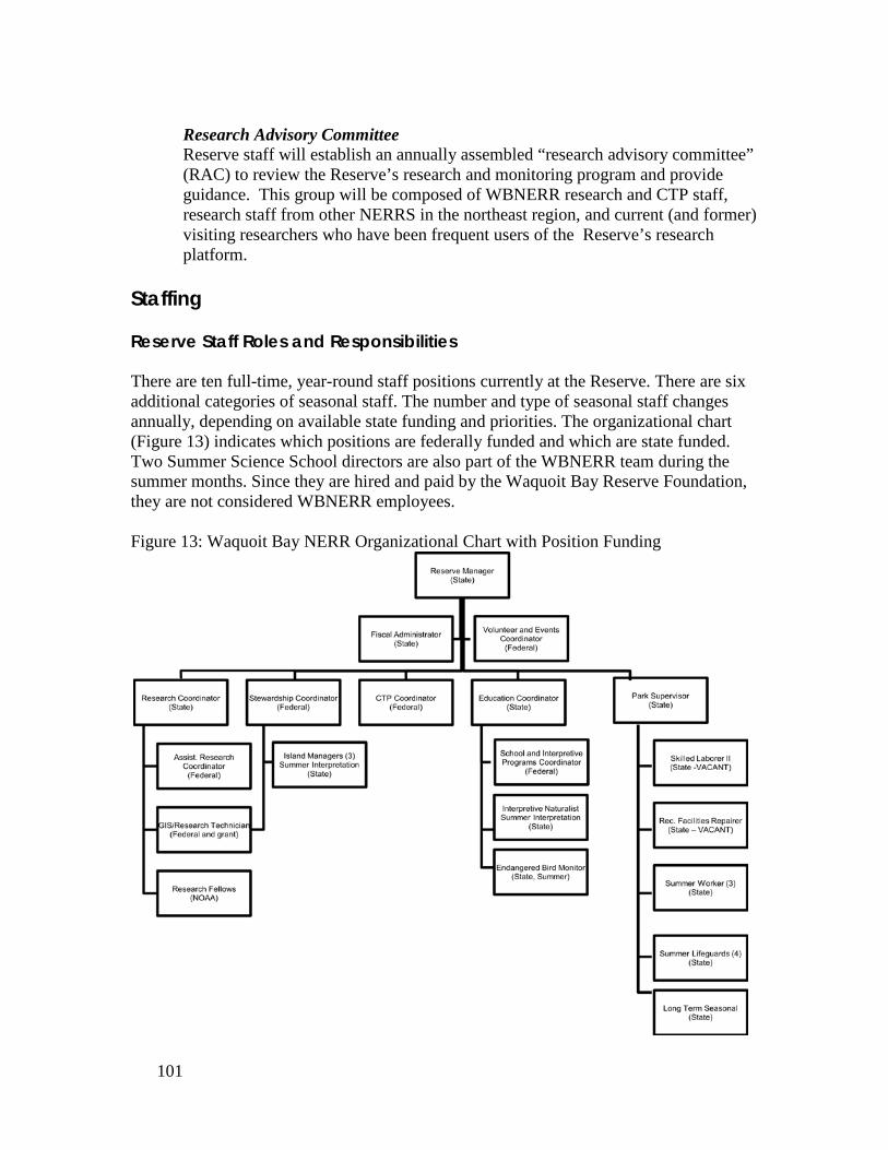
Research Advisory Committee Reserve staff will establish an annually assembled “research advisory committee” (RAC) to review the Reserve’s research and monitoring program and provide guidance. This group will be composed of WBNERR research and CTP staff, research staff from other NERRS in the northeast region, and current (and former) visiting researchers who have been frequent users of the Reserve’s research platform.
Staffing Reserve Staff Roles and Responsibilities There are ten full-time, year-round staff positions currently at the Reserve. There are six additional categories of seasonal staff. The number and type of seasonal staff changes annually, depending on available state funding and priorities. The organizational chart (Figure 13) indicates which positions are federally funded and which are state funded. Two Summer Science School directors are also part of the WBNERR team during the summer months. Since they are hired and paid by the Waquoit Bay Reserve Foundation, they are not considered WBNERR employees. Figure 13: Waquoit Bay NERR Organizational Chart with Position Funding
101

Year-Round Reserve Staff Job Descriptions Particularly with the emphasis in this plan on integrated projects, one of the responsibilities of all staff members is to function as part of a team, and actively seek the engagement of their colleagues when appropriate. “Does this research project address the needs of our stakeholders?” “What kind of translation products might come out of this monitoring study?” “How can I better showcase work the Reserve is doing in brochures, talks, or signage?” This type of thinking, and the staff interactions it necessitates, is encouraged at staff meetings and retreats, and in informal discussions. The close quarters of our office facilities lends itself to this type of cross-pollination.
Reserve Manager The Reserve Manager is the principal administrator of the Reserve and is responsible for ensuring that the policies in the Reserve Management Plan are followed and that Reserve programs successfully meet the mandates of the national and state programs responsible for the Reserve. The Reserve Manager has overall responsibility for all activities, lands, and facilities within the Reserve boundaries—including those at South Cape Beach and Washburn Island. The Reserve Manager has ultimate responsibility for the research, education and stewardship programs and is also the principal point of contact at the Reserve for DCR, NERRS and outside agencies. This person also spearheads Strategic Planning and determines the general direction the Reserve is headed in. Research Coordinator The Research Coordinator is responsible for coordinating all Reserve research and monitoring efforts. This includes coordinating the use of Reserve resources and facilities by visiting researchers; developing funding sources for research; developing, implementing, and evaluating in-house research and monitoring efforts; supervising those working on in-house research and monitoring projects; and representing the Reserve on matters related to research and monitoring. This person has overall responsibility for SWMP operations, data submissions, and data quality. The Research Coordinator also represents the research interests of the Reserve to the NERRS and implements NERRS research program objectives at the Waquoit Bay Reserve. Research Technician The Research Technician assists the Reserve's Research Coordinator by coordinating the technical aspects of the Reserve’s System-Wide Monitoring Program (SWMP) and other ecological monitoring programs, including citizen volunteer programs. Responsibilities include carrying out all water quality, meteorological, and biological monitoring components of SWMP; maintaining all SWMP-related field and laboratory equipment; and performing laboratory analysis for SWMP. This position also is responsible for maintenance of the Geographic Information System database for the Research, Education, Stewardship and Management programs.
102

Coastal Training Program Coordinator The Coastal Training Program (CTP) Coordinator directs, provides, and organizes training and other educational opportunities concerning coastal management issues and estuarine research for resource managers, local and state government officials, environmental planning organizations and other coastal decision-makers throughout coastal Massachusetts, and communicates coastal management research needs to members of the scientific community. In this role, the CTP Coordinator prepares and updates training strategy and program implementation documents; conducts and/or supervises needs assessments of regional coastal decision-makers to determine their scientific information and training needs; works to identify upcoming coastal and estuarine science and management issues that may yield opportunities for coastal decision-maker training; represents the Reserve regarding CTP issues in interactions with the NERRS system, including all other CTP programs, and NOAA; develops partnerships and coordinates with other training providers and users; and collaborates with the Reserve’s education, research and stewardship staff to develop and evaluate the means to transfer scientific information to the resource management, scientific and governmental communities. Education Coordinator The Education Coordinator is the principal link between the research efforts of the Reserve and the general public and develops and carries out various types of Teacher Training Programs and Community Education Programs including engagement with underserved audiences. The Education Coordinator also provides interface with the NERRS national program, serves on state and other regional boards, evaluates programs, and seeks out grants. During this Management Plan timeframe, this person will be heavily involved in developing interpretive signage and exhibitory. The Education Coordinator is responsible for overall coordination of the education programs at the Reserve and supervises the School and Interpretive Services Coordinator. School and Interpretive Program Coordinator The School and Interpretive Programs Coordinator works in the schools and on site to reach curriculum objectives through lessons in coastal ecology and management. Specifically, this person:
• Recruits, trains, and supervises volunteers for education programs; • Develops teaching materials based on research and monitoring from
Waquoit Bay Reserve, the Reserve system, and other relevant research; • Provides information, consulting services, and teaching materials about
coastal ecology to teachers, researchers, and students; • Serves on committees to carry out the mission of Waquoit Bay Reserve; • Provides field-based educational experiences for students, such as pond
monitoring and beach profiling. • Supervises an AmeriCorps member, seasonal interpretive staff, and interns • Oversees interpretive program at Reserve and acts as liaison between the
Reserve and DCR Interpretive Services.
103

Stewardship Coordinator The Stewardship Coordinator is responsible for leading long-term protection and management of the Reserve’s natural resources. This includes natural resource inventory and mapping, land management, and habitat/ecosystem restoration. The Stewardship Coordinator is also primarily responsible for many of the long-term monitoring programs, including the salt marsh observatory. Stewardship activities involve aspects of research, monitoring, education, policy and traditional forest and parks management; thus, the Stewardship Coordinator works as part of a team with the Reserve’s Manager, Research Coordinator, Education Coordinator, Forest and Parks Supervisor and other agency resource management staff. Since the long-term health of the Reserve’s resources are dependent on land use in the entire watershed, and since the Reserve has regulatory jurisdiction only on DCR owned land and not on the open water within the Reserve, the person in this position must work closely with local, state and Federal officials, as well as with local land owners, to manage natural resources affected by activities outside of DCR lands. This person also coordinates and prioritizes the GIS needs of the Reserve. Fiscal Administrator The Fiscal Administrator is responsible for processing all financial materials, all grants and contracts (personnel and otherwise), all purchases and contributions for the state and Federal program partners. This staff person functions as office manager. The Fiscal Administrator also schedules facilities and provides administrative support to all Reserve programs and the numerous projects within each program area. Event and Volunteer Coordinator The Event and Volunteer Coordinator is responsible for supporting the CTP, Education, Stewardship and Research departments in the coordination of workshops, adult education and training opportunities and other community events. As the event coordinator this position also acts as the liaison to DCR external affairs in coordinating DCR sponsored press events. This position is responsible for program logistics, marketing and outreach, registration, and follow-up. The Volunteer and Events Coordinator is also responsible for overseeing volunteer activities at the Reserve, including recruitment, training and supervision of Visitor Center greeters, and evaluation of volunteer satisfaction. This position also supports the Fiscal Administrative Assistant when needed. Forests and Parks Supervisor The Forests and Parks Supervisor (currently Acting) has day-to-day responsibilities for the Reserve's facilities, lands, and equipment. The Supervisor is a critical member of the Reserve staff also oversees the operation of South Cape Beach State Park and supervises a large summer staff. The Forest and Parks Supervisor manages many of the contracts and contractors on the property. The Park Supervisor works with the Stewardship Coordinator and Reserve staff to
104

apply research information to management of Reserve property. This position is currently vacant. Laborer The Laborer assists the Park Supervisor in the completion of assigned tasks related to facilities, lands, equipment, and operations of the Reserve. This position is currently vacant. Facilities Repairer Working with the Forests and Parks Supervisor and the Skilled Laborer, the Facilities Repairer maintains the buildings, land and equipment and is able to perform basic plumbing and carpentry.
Seasonal Staff Job Descriptions
Interpretive Naturalist The Interpretive Naturalist offers regularly scheduled interpretive programs at Reserve Headquarters, South Cape Beach State Park, and off-site. The Interpretive naturalist also offers special programs to visiting groups, as well as at off-site locations. Island Managers Island Managers are responsible for managing camping on Washburn Island, including checking camping permits, enforcing policies, patrolling the Island, and providing roving interpretation. Long-Term Seasonal Staff This position assists the Forests and Parks Supervisor in maintaining buildings and grounds at the Reserve. Summer Workers The Summer Workers assist the Forest and Parks Supervisor in maintaining facilities and managing visitor usage of Reserve lands, including South Cape Beach State Park. Life Guards Life guards stationed at South Cape Beach are responsible for swimmer safety. One life guard is designated as a Head Life Guard and given supervisory authority over Life Guards and Summer Workers at South Cape Beach. The Head Life Guard is responsible for daily training and position rotation.
105

Future Staffing Plan The Reserve accomplishes a great deal with existing staff. We could, however, significantly increase our impact and reach with just a few more staff. This section outlines some of the needs and priorities for additional staff, should additional funding become available (not in order of priority).
Communications Specialist: One of the goals of this period is to increase visibility of the Reserve, raise awareness of what we do, and reach new audiences with our message. A Communications Specialist would create written and graphic materials, brochures, signs, do web design and maintenance, and manage social media. They could schedule speaking engagements for staff at community groups, and reach out to volunteers and other interested parties. School Programs Assistant: Teach student programs. As word of the excellence of our school programs spreads, we continually get requests from new school districts wanting to bring classes here. We are unable to accommodate them at current staffing levels. This position would enable us to reach more school groups. Teacher Training Coordinator: Support teachers including conduct teacher training and develop supporting materials. Again, we could offer more Teacher trainings if we had another staff person to coordinate and carry out these programs. Two Coastal Training Program Assistants: These positions would enable the CTP to meet the demands of a growing program and increasing information needs within our target audience. CTP Assistants would be responsible for helping to expand reach of the program into different areas, and increasing access to CTP trainings by helping to take more CTP trainings on the road. They would also be responsible for working with the CTP Coordinator and other Reserve staff to develop more science translation and products for coastal decision-makers. Lastly, they would enable the CTP to be more responsive to requests for technical assistance and contribute to supporting community coastal management efforts. Research/Monitoring Assistant: the addition of this position would increase our ability to analyze and translate our monitoring data, review and evaluate current monitoring projects, make datasets and results available on our website.
106

Staff Training and Emergency Response
WBNERR staff are encouraged to pursue training that will assist them to better perform their jobs. Training may take the form of conferences, workshops, courses related to their job functions, and lectures. WBNERR also provides training to seasonal staff that covers the following topics:
• Interpretive techniques • First aid/safety/CPR • Wampanoag history and culture • Coastal plants • Salt marsh and estuarine ecology • Groundwater and watersheds • Cape Cod coastal geology • Solutions to coastal environmental problems
In addition, staff are required to complete a number of DCR trainings, including:
• Diversity in the Workplace • Preventing workplace violence • Preventing discrimination and sexual harrassment in the workplace • Conflict of interest law • Disability awareness • Safeguarding Confidentiality of Personal Information • Introduction to the Incident Command System
Because of the wide range of activities undertaken by Reserve staff members, visiting researchers, educators, users of recreational facilities, and others on Reserve property or under its auspices, there is a strong need to develop and implement emergency response
Objective 5.7: WBNERR staff is prepared to respond appropriately to a variety of emergency situations. WBNERR staff will:
a. Review existing emergency response procedures annually and update as necessary.
b. Develop Emergency Response Plans for incidents that occur on parcels for which a plan does not already exist.
c. Be trained in emergency response procedures. d. Place copies of Emergency Response Plans in key locations. e. Continue to include emergency planning in seasonal training.
Objective 5.6 WBNERR staff will augment their expertise with appropriate training.
a. WBNERR management will facilitate and support staff training opportunities when possible and appropriate.
107

procedures. WBNERR has written emergency response protocols for lab accidents and incidents on Washburn Island. There are also standard operating procedures for emergency incidents that occur on any DCR property. These plans will be reviewed annually to ensure their continued relevance and accuracy (e.g., phone numbers will be confirmed). With significant help from a volunteer from the Massachusetts Maritime Academy, the Reserve developed an Emergency Response Plan for incidents that occur on Reserve lands. This plan was reviewed by DCR Rangers and Management for approval. In addition it will be reviewed periodically for accuracy (phone numbers, etc). The Reserve developed its Hurricane Response Plan and implemented it in summer 2010 in response to a threat from Hurricane Earl, in summer 2011 in response to Hurricane Irene, and in 2012 for Hurricane Sandy. All Reserve staff including seasonal employees completed a Red Cross First Aid and CPR training in summer 2011 and most did again in 2012. We anticipate repeating this training annually for summer staff and to keep year-round staff certifications current. All year-round staff completed FEMA Incident Command System Training (ICS 100 and 700). A portion of the seasonal staff's formal training at the start of each season is dedicated to emergency response procedures. New research staffers are introduced to safety protocols and equipment in the lab. Emergency response procedures will be reviewed with all existing staff members. New employees will be given copies of the protocols as part of their orientation. Additionally, copies of all emergency response plans will be inserted in brightly-colored binders and placed in key locations: administrative office, lab, maintenance shop, and boat house. Volunteers
Volunteers are vital to the ongoing success of many Reserve programs. Volunteers participate in water quality and shorebird monitoring programs and act as trail stewards and visitor greeters. Volunteers also help organize events, provide administrative support,
Objective 5.8: Volunteers will support implementation of Reserve programs. WBNERR staff will:
a. Enhance volunteer retention and recruitment strategy. b. Conduct annual volunteer satisfaction surveys to help guide
improvements to volunteer program. c. Expand ongoing training and educational opportunities for volunteers. d. Enhance volunteer recognition. e. Encourage cross participation of volunteers with Waquoit Bay Reserve
Foundation (the Reserve's Friends Group). f. Encourage a subset of volunteers to assume leadership roles in
coordinating and taking ownership of projects.
108

and assist with maintenance activities. Because of the critical importance of volunteers to the successful implementation of Reserve programs, the Reserve is dedicated to attracting new, and retaining existing, volunteers. The Reserve actively recruits volunteers in the spring through press releases, articles in local publications, open houses and social media. The Reserve provides numerous training opportunities to ensure, to the greatest extent possible, that volunteers fully and accurately represent the Reserve to the public. Volunteers are, after all, the "face" of the Reserve to many visitors. Volunteers are also likely to share their enthusiasm for the Reserve with their friends and family. They have the potential, therefore, to play another important role for the Reserve: that of a stewardship "advocate." With this in mind, a wide variety of training opportunities are available to volunteers. Training activities include informational sessions with staff, courses on some of the Reserve's priority issues, and workshops outlining research, educational programs, and stewardship activities. The Reserve expresses its appreciation to volunteers through several events each year including open house events, potluck dinners, and coffee hours which afford volunteers the opportunity to meet like-minded individuals within the community. There is also an annual recognition event or field trip where staff and volunteers gather to celebrate the commitment and dedication of the volunteers. The “Volunteer of the Year” award is presented during this educational and festive event. The Waquoit Bay Reserve Foundation (WBRF) is another volunteer group that supports the Reserve and its programs. Reserve volunteers are encouraged to join this "Friends Group" and to regularly participate in events organized by the Foundation. To further enhance the support volunteers provide to the Reserve, staff will identify individuals to assume leadership roles. Individuals who are inclined to accept this sort of responsibility will derive satisfaction from the knowledge that their time and effort is supporting the Reserve's mission in a substantial and meaningful way. In 2012, the first annual volunteer satisfaction survey was undertaken. In part, this will act as one of the three new 312 Evaluation Reserve-wide metrics to be implemented in the next 5 years.
109

Technology
Technology supports and, in many cases, enables the work of all Reserve staff. For example, the System-wide Monitoring Program relies upon wireless transfer of data. Staff will stay up-to-date through discussions with colleagues at other Reserves, our EEA IT department, and elsewhere on technologies used for education, training, and research, and will evaluate their relevance for our programming. Furthermore, if possible, WBNERR will budget the funds necessary to obtain new technologies and will work with the EEA Information Technology department to continue modifying acquisition strategies to streamline technology purchases and support WBNERR programs, including wireless network and SWMP. Once new technologies are obtained, WBNERR staff will provide training (or will arrange for training by a third party) to insure that the new equipment is used appropriately and to its full capacity. One change since the previous Management Plan is that WBNERR no longer has a dedicated IT person, and even the DCR IT person who was available to us one day a week is now under EEA and spread much thinner. Weeks often go by before he is able to respond to our requests. The Reserve also serves as a field testing facility for the application of new equipment of the use of existing technologies in new ways for both research and education. Both reserve staff and guest researches will continue to use the Reserve and its infrastructure to test new technologies, sensors, or equipment to detect abiotic change and community response to environmental stressors.
Objective 5.10: All Reserve programs benefit from the Reserve's Geographic Information Systems (GIS), as do selected community partnerships. GIS staff will:
a. Accurately maintain GIS data produced by the Reserve. b. Support Reserve programs and partnerships by producing GIS products.
Objective 5.9: Reserve programs are fully supported with state-of-the-art technology. WBNERR staff will:
a. Continue to keep up-to-date on the latest technologies necessary for all departments.
b. Continue to set aside a portion of the budget, as funding allows, meeting the growing technology needs of staff for items such as computers, software, copiers, scanners, tablets, interactive technology for the Visitor Center, and other equipment and training.
c. Work with the EEA Information Technology department to streamline technology purchases and support existing networks, wireless technology, and the System Wide Monitoring Program.
d. Provide the training necessary for utilizing these technologies.
110

The GIS/Research technician is responsible for accurately maintaining GIS data produced by the Reserve. Data is in a variety of formats and is documented according to Federal Content Standards for Digital Geospatial Metadata. The data—collected through geographic positioning systems (GPS), remote sensing and collaboration—is used in-house and by local towns and State agencies. In addition to maintaining data, the GIS/Research technician assists staff from all departments to use the data by producing maps that are used for planning purposes, in education programs, and in publications. When necessary, the GIS/Research technician will draw upon the expertise of outside GIS specialists in support of Reserve activities. Communications Plan
The Reserve's communication plan supports and advances work in all program areas. Through effective communications, WBNERR enhances the visibility and reputation of its core programs, attracts participants to Reserve events, and provides information about specific services available to key audiences. Communications efforts help define the relevance of WBNERR for scientists, coastal decision-makers, educators, the general public, and DCR. All communication pieces—newsletters, press releases, presentations, etc.—emphasize the Reserve's leadership role in addressing current estuarine and coastal management issues through science and monitoring, training and education, and stewardship. Coastal decision-makers, researchers, and teachers must be aware of the Reserve's services and programs in order to take advantage of them. Toward this end, WBNERR has a brochure that summarizes the Reserve's activities and facilities and includes a map depicting the Reserve's land holdings and hiking trails. The Reserve also has an information packet that describes the Coastal Training Program. It contains a brochure and other materials that summarize how the CTP provides up-to-date scientific
Objective 5.11: Individuals, organizations and communities in coastal Massachusetts recognize WBNERR as a center of excellence for research, training, education, and stewardship. WBNERR staff will:
a. Continue to produce and distribute publications and brochures. b. Ensure that all publications are professionally produced with a consistent look. c. Continue to write articles for magazines and e-newsletters. d. Continue to make presentations to organizations and at workshops and
conferences regarding Reserve programs. e. Further promote the availability of Reserve staff to speak to civic groups and
other organizations. f. Enhance relationships with local media outlets: newspapers, radio and
television. g. Engage in social media outreach including Facebook, Constant Contact,
Linked In, Twitter and others. h. Keep Constant Contact email lists up-to-date.
111

information and skill building opportunities to coastal decision-makers. The Reserve will continue to produce and distribute these materials. The Reserve also serves as a field testing facility for the application of new equipment of the use of existing technologies in new ways for both research and education. Both reserve staff and guest researches will continue to use the Reserve and its infrastructure to test new technologies, sensors, or equipment to detect abiotic change and community response to environmental stressors. To help support WBNERR's image as a credible source of information on a variety of coastal management issues, Reserve staff will develop all publications with a consistent look and tone. Whenever possible, publications will be professionally produced. WBNERR conveys its messages through direct interaction with people as well. Reserve staff regularly makes presentations to professional and lay audiences. Non-professional audiences are also very important to the realization of the Reserve's goal of promoting environmental literacy. Toward this end, Reserve staff is available to speak to civic groups and other parties about WBNERR's priority issues. WBNERR presently enjoys good coverage in the local press as a result of media releases issued by the Reserve and general media coverage. To garner further or more in-depth coverage of WBNERR activities and events, The Reserve will continue to foster relationships with the local media outlets to keep them informed, resulting in better news coverage locally. Reserve staff will continue to expand our online newsletter outreach and Facebook audience, as well as research new technologies to reach a broader audience. When program participants sign up to receive emails, their addresses will be added to the database.
Objective 5.12: An increasing number of community members are aware of WBNERR's research, stewardship or monitoring programs. WBNERR staff will:
a. Create more lessons and activities based on the Reserve’s research, monitoring and stewardship programs.
b. Actively foster links and partnerships between educators and researchers. c. Ensure that individual research projects are described in the Constant Contact
communications and on the website. d. Garner greater press coverage of research activities. e. Actively reach out to community groups to suggest Reserve staff give talks
about the Reserve and its message. f. Continue to participate in community events, science fairs and festivals. g. Work with outside researchers to ensure that they credit the Reserve and
NOAA when giving presentations or submitting journal articles.
112

Many people, who are familiar with WBNERR, are unaware of the full breadth of activities conducted at and supported by the Reserve. For example, teachers are likely to know about educational offerings but may be unfamiliar with the Reserve's research and stewardship activities. By making teachers—and all audiences—more aware of the comprehensive nature of its commitment to estuarine health, WBNERR will gain credibility and stature among community members. Toward this end, lesson plans based on the Reserve’s research, monitoring, and stewardship programs will be developed and made available on the Reserve’s website. Additionally, the Reserve actively fosters links and partnerships between educators and researchers in order to involve students at the elementary, secondary, and collegiate levels in science, whether it be in the field or in the classroom. Through this technique, the results of research and monitoring at the Reserve are made readily available to students and teachers. Descriptions of research projects conducted at the Reserve are included in the newsletter and on the website. The Research @ Reserve series where scientists doing research at the Reserve present their projects to lay audiences in an informal coffee house setting will continue. Reserve staff will also prepare press releases and draw upon relationships with members of the media to expand press coverage of WBNERR’s research activities. They will also work with researchers that use WBNERR as a study site to insure that the Reserve and NOAA are properly credited in publications and presentations. One of the new performance measures is: Number of new people per year that come to programs or volunteer at the Reserve as a result of an off-site talk given by a Reserve staff member. In order to achieve this goal, Reserve staff will make a concerted effort, in partnership with the Waquoit Bay Reserve Foundation, to reach out to community groups such as church groups, Rotary, and alumni clubs to give talks about the Reserve and its work. Attendees will be encouraged to attend programs at the Reserve, volunteer, join the Foundation, or otherwise become involved.
The Reserve’s primary website: www.waquoitbayreserve.org hosts general information about the Reserve, lists news and publications, provides camping information, and includes additional content areas for education, monitoring, GIS, research, and workshops and events.
Objective 5.13: Citizens, educators, researchers, and coastal decision-makers rely on the Reserve website as a valuable tool. WBNERR staff will:
a. Ensure that the WBNERR website consistently provides dynamic information to the public about the Reserve's purpose, core programs, and events.
b. Maintain current information about educational resources and programs on the WBNERR website.
c. Continue to host monitoring data on the WBNERR website. d. Update and maintain other information about research studies and
publications.
113

The Education content area will be improved to include descriptions of teacher training programs, lesson plans, resources for teachers, and links to the Massachusetts Curriculum Frameworks. Monitoring data will also be maintained on the website as aids to both researchers and educators. To improve the level of support to researchers and other users, the Research content area will be updated to include titles and abstracts of current research projects and publications and will incorporate the additional data described in Objective 1.7.
114

Bibliography Dempster, F. 1991. Synthesis of Research on Reviews and Tests. Journal of Educational Leadership. 48(7). pp. 71-76. Lapointe, A. E., Askew, J. M., & Mead, N. A. (1992). Learning science. Princeton, NJ: Educational Testing Service. Massachusetts Department of Conservation and Recreation, 2004. Waquoit Bay National Estuarine Research Reserve Cultural Resource Management Evaluation (prepared by Thomas F. Mahlstedt. Massachusetts Department of Conservation and Recreation, 2005. ACEC Regulatory Summary, website viewed January 2005, http://www.mass.gov/dcr/stewardship/acec/index.htm USFWS. 1995. Final Environmental Assessment Mashpee National Wildlife Refuge. U.S. Department of the Interior, Fish and Wildlife Service, Region 5, Hadley, MA.
115

Waquoit Bay National Estuarine Research Reserve Management Plan 2014-2019
Volume II: Appendices
A. 1
Appendix A DCR’s Landscape Designations and Stewardship Zoning
Overview Reserve lands are managed in accordance with the Massachusetts Department of Conservation and Recreation's Landscape Designations and Stewardship Zoning Guidelines. These designations and guidelines are described in this chapter. Landscape Designations All Department of Conservation and Recreation lands are classified under one of three Landscape Designations Each designation has its own set of ecosystem services and management priorities (excerpted from DCR Parks & Forests: Selection Criteria and Management Guidelines. March 2012). The Landscape Designation process was completed in 2012 for all DCR lands. The three designations are
Reserves are high-value ecosystems where the dominant ecosystem service objectives will be maintenance of biodiversity, nutrient cycling and soil formation, and long-term carbon sequestration. Reserves are areas that may be valued for spiritual reasons or to provide a wilderness recreational experience. Forest management will be restricted to fire management or habitat enhancement for rare species. Parklands conserve unique natural and cultural resources while focusing on the provision of recreation. Management approaches are expected to range from areas where natural processes dominate to highly modified environments where use is intensively managed. Woodlands conserve a range of forest ecosystems, where recreation activities and sustainable forest management will continue. These areas will provide a wide range of ecosystem services, including: production of high-quality, local, renewable wood products, protection of water quality, carbon sequestration, and different successional stages to promote habitat diversity.
Land Use overlays As part of the Department of Conservation and Recreation planning process each DCR facility will have a Resource Management plan prepared which further refines management options and restrictions by apply a series of land use overlays on top of the underlying landscape designation. DCR has initiated a Resource Management Plan for a group of properties, including those in WBNERR, and Land Stewardship Zoning maps will be included in that plan, which is scheduled for completion in 2014. We have therefore not included these designations here, as they would be immediately outdated.
A. 2

These zones will be consistent with the regulations under the CZMA under which the Reserve was designated and will include further information on high use recreation areas as well as significant feature overlays such as Protected Species Habitats, Cultural Resource Areas, and the Waquoit Bay Area of Critical Environmental Concern (ACEC) See Appendix E for ACEC description and map. See Figs. 14 through 20 below for DCR Landscape Designations on Reserve properties. Headquarters and Childs River Areas The Headquarters Area (Figure 14) includes all of the Reserve’s buildings, including the visitor center, office, laboratory, classroom, meeting and maintenance space, as well as associated parking lots and boat and equipment storage areas. The entire parcel is categorized as Parkland.. The area where the new maintenance building is being constructed also falls in this category. These areas are a relatively resilient landscape immediately adjacent to the concentrated intensive use area of the other facilities, but a thorough ecological and archaeological site assessment must be conducted prior to work activities for such development. South Cape Beach Area Most of South Cape Beach is classified as a “Reserve.” The state beach parking lot and the recreational areas (beaches and trails) are classified as Parklands. Much of the South Cape Beach Area, will be covered by a Significant Feature Overlay for Protected Species Habitat for shorebirds including piping plover (Charadrius melodus) and least tern (Sterna antillarum) when the Resource Management Plan process is completed. Washburn Island Washburn Island (Figure 16) is classified as a Reserve. Despite its popularity and heavy recreation use during summer, the Island and its beach, dune, barrier habitat, wetlands (salt and fresh, including vernal pools) and woodlands have been recognized for their importance to the coastal and estuarine ecosystem. Quashnet River Area (including the 10 acre satellite “Phinney Property”) Both parcels are categorized primarily as Woodlands. The Quashnet River Area is actively management for upland species including New England Cottontail. The “Woodland” designation allows for this active management strategy. (Figure 17: Quashnet River Area (including the satellite “Phinney Property”). Abigail Brook Area The entirety of the Abigail Brook property (Figure 18) is comprised of mixed pine/oak woodland and is classified as “Reserve”: North Quashnet Area The entirety of the North Quashnet property is comprised of mixed pine and oak and (Figure 19) is designated as “Woodland”
A. 3

Caleb Pond Parcel The Caleb Pond parcel is an abandoned agricultural site with younger hardwoods, pitch pine overstory and a shrub layer of both native and non-native species. It is classified as “Reserve”. (Figure 20). Figure 14: Headquarters and Childs River Areas.
A. 4

Figure 15: South Cape Beach Area.
A. 5

Figure 16: Washburn Island Area.
A. 6

Figure 17: Quashnet River Area (including the satellite “Phinney Property”).
A. 7

Figure 18: Abigail Brook Area.
A. 8

Figure 19: North Quashnet Woods Area.
A. 9

Figure 20: Caleb Pond (new parcel).
A. 10

Appendix B 2007 312 Evaluation Findings
The evaluation team documented a number of WBNERR’s accomplishments during the review period. These include:
Issue Area Accomplishment
Staffing DCR made improvements in hiring and staffing at the reserve. The department appointed a specific Human Resources Liaison to work directly with WBNERR and also began providing the reserve with the annual seasonal staff roster earlier each year.
Management Plan
WBNERR produced a well-written revised Management Plan within the prescribed timeframe. The comprehensive plan will provide overarching guidance for the reserve as it continues to evolve. Such planning and guidance will allow WBNERR to operate proactively and to respond to challenges and emerging issues more effectively.
Coordination and Communication
WBNERR and MCZMP significantly improved their coordination and communication with each other during the review period.
Geographic Information System
The application of GIS at the reserve has enhanced the precision and usefulness of data produced for ongoing projects such as habitat classification.
Research Partnerships
The Research and Monitoring Program engages in many collaborative partnerships and attracts high-caliber, innovative research to the reserve. A significant amount of research at the reserve is conducted by external researchers.
K-12 and Professional Teacher Development
The Education and Outreach Program offers high-quality K-12 education and professional teacher development that are closely correlated with the reserve’s research priorities as well as with state education standards. K-12 programs engage students in learning by addressing significant regional environmental issues and by incorporating data and findings from the Research and Monitoring Program. The Education and Outreach Program also targets pre-service teachers to help them incorporate estuarine and coastal elements into their curricula.
Coastal Training Program
MCTP is a strong partnership among WBNERR, MCZMP and Woods Hole Oceanographic Institution Sea Grant Program. The program holds successful coastal decision-maker workshops on key coastal issues, fosters increased communication and understanding among its target audiences, and develops innovative new partnerships.
In addition to the accomplishments listed above, the evaluation team identified several areas where WBNERR could be strengthened. Recommendations are in the form of Program Suggestions. The evaluation team did not identify any Necessary Actions. Areas for improvement include:
A. 11

Issue Area Program Suggestion Staffing While recognizing that DCR’s ability to affect the hiring system required by
EOEEA is limited, OCRM continues to urge that the department explore potential methods of reducing the time that positions at the reserve remain unfilled. In order to ensure continuity of the reserve’s programs and services, vacancies should be filled as expeditiously as possible.
Facilities OCRM encourages WBNERR to continue its assessment of the feasibility of constructing a dock at reserve headquarters. As part of the assessment, WBNERR should systematically examine all practical alternatives, including potential partnerships that might allow the reserve to share use of an existing structure.
Reserve Advisory Committee
OCRM strongly recommends that WBNERR and DCR take the steps necessary to re-establish a representative RAC as soon as possible.
Coordination and Communication
OCRM strongly recommends that DCR and WBNERR work together to improve communication among the reserve and DCR’s sister agencies within EOEEA.
A. 12
Appendix C Summary of Public Review Process No comments were received during the Federal public comment period The Reserve held a public meeting on the Management Plan on June 30, 2014, below is the notes from that meeting
Waquoit Bay National Estuarine Research Reserve Management Plan Meeting
June 30, 2014 1. What is the public perception of what WBNERR is?
What is coastal management? How much of what WBNERR does is about land and how much is about water issues (e.g., nitrogen). Acting Manager Jim Rassman (J.R.) provided a response that addressed that water issues lead us upstream to the rest of the watershed.
2. Did the Stewardship Coordinator (Jim Rassman) take the oil spill class as indicated in the draft plan?
J.R. indicated that he took the training. 3. A member of the public indicated that they were having trouble reaching the right
person via the WBNERR voice mail system. J.R. indicated that the phone system does have problems, it is complicated to reprogram, and that IT support for WBNERR is not based on site. He indicated that the master plan needs to identify that the “phone system has problems that need to be addressed.”
4. A recent article in the Mashpee Enterprise indicated that the town has a town meeting
warrant article to regulate lawn fertilizer. A member of the public asked J.R. to comment on the effects of golf course use of fertilizer on water quality. J.R. addressed WBNERR outreach and education programs that address use of fertilizers, he stated that because golf courses cover hundreds of acres, it makes it easier for the education program to have a large impact; he reminded the audience that homeowners have a larger cumulative input of nitrogen than do golf courses and it is harder to reach multiple homeowners with outreach and education programs; finally, he indicated that reducing inputs of atmospheric nitrogen is a national issue.
5. A seasonal resident who also lives in Florida observed that Florida regulations are
stronger in addressing use of fertilizers. The speaker had provided Tonna-Marie Rogers (Coastal Training Program Coordinator) information on the regulations and outreach so that she could prepare educational materials for Waquoit Bay. They asked “Where is Tonna-Marie on developing similar materials for WBNERR?” WBNERR staff indicated that she is working on this as time permits.
A. 13

A broader discussion then followed about the need to educate the public about nitrogen. A member of the audience indicated that WBNERR should encourage natural meadows instead of lawns.
6. Is there a Cape-wide marketing plan for increasing awareness of WBNERR’s activities?
J.R. reviewed efforts to brand WBNERR through consistent signs, web page, etc., and to use emerging technologies (e.g., Twitter, Face Book) to get their message out.
7. A member of the public (Jane Abbot) then entered into a series of comments about
written comments on the plan that she had submitted earlier in the evening. This led to a discussion about the possible decline of beach plum.
8. The things that you are talking about (in the plan) are important to a lot of people.
J.R. The public can help WBNERR’s messages reach more people. 9. What is in the plan about expanding eelgrass?
J.R. told the attendees that the eelgrass story is the nitrogen story. He then indicated that we are so focused on reducing nitrogen that we haven’t thought enough about what will happen to eelgrass once the nitrogen is under control. The high nitrogen levels have produced anoxic conditions in bay sediments that might prevent the recovery of eelgrass. Efforts need to focus on how we can help restore eelgrass once nitrogen levels are reduced; this might require targeted research, special monitoring programs, etc. The reserve should help focus research efforts on this question.
10. How is WBNERR reducing nitrogen input into the bay? (Asked by Sam Houghton, a
reporter from the Enterprise newspapers.) J.R, indicated that most efforts have been to reduce the reserve’s carbon footprint by installing photovoltaic, solar hot water, adding insulation to reduce heating fuel consumption, etc. However, steps have been taken to reduce nitrogen, including a septic leach field that is different than normal that will be the subject of future research, and the installation of a permeable reactive barrier (Nitrix Barrier) along the shore. The reactive barrier is filled with wood chips and lime, and removes more than 95% of the nitrogen. The comments then expanded to discuss alternatives to the permeable reactive barrier (e.g. injection wells).
11. You should include information on the reserve’s generation of solar electricity in the
plan. J.R. indicated that this information is readily available on line. Despite this, the audience member wanted to see the information in the master plan.
12. When preparing a five-year plan, how do you factor in uncertain funding in the future?
J.R. went through NOAA and DCR funding.
A. 14
13. J.R. made the audience aware that there is an upcoming conservation commission hearing on WBNERR’s request for a variance from town wetland bylaws so that they may install a dock at the reserve.
14. A member of the audience indicated that the plan is well done, and that they are motivated to give the reserve all the help that they can.
Meeting notes prepared by Paul Cavanagh, July 1, 2014
A. 15

Appendix D Federal Consistency Certification – needs to be updated after their review
A. 16

Appendix E Waquoit Bay Area of Environmental Concern (ACEC)
ACECs are places in Massachusetts that receive special recognition because of the quality, uniqueness, and significance of their natural and cultural resources. The State Department of Conservation and Recreation (DCR) administers the ACEC Program and closely coordinates with the Massachusetts Office of Coastal Zone Management (MCZM) regarding coastal ACECs. The Waquoit Bay ACEC (Figure 21) has boundaries nearly identical to the Reserve, mainly differing in extent of tidal river protection. In relation to the Reserve boundary, the ACEC includes greater extents of the Childs and Quashnet Rivers; Red Brook; Jim, Little, Flat and Witch ponds; and of a few tributaries. However, the Reserve boundary includes Great and Little Rivers and the ACEC boundary does not. The purpose of the ACEC designation is to preserve, restore, and enhance the natural and cultural resources of the area. The goals of the designation are achieved through the application of stricter standards under existing state regulations, through priority attention from state agencies for technical assistance, grants, or other programmatic means, and through cooperative stewardship efforts from citizens to Federal agencies. A synopsis of regulations that apply stricter standards within ACECs follows. It is important to note that ACEC designation does not create new regulations, nor does it supersede local regulations or zoning. For further information concerning regulatory effects of ACEC designation, see www.mass.gov/dcr/stewardship/acec/regsum.htm for a quick summary or www.mass.gov/dcr/stewardship/acec/acecGuide.pdf for a complete guide.
A. 17
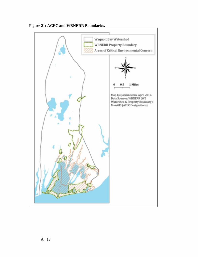
Figure 21: ACEC and WBNERR Boundaries.
A. 18

Designation Document:
A. 19

A. 20

A. 21
A. 22

A. 23

A. 24
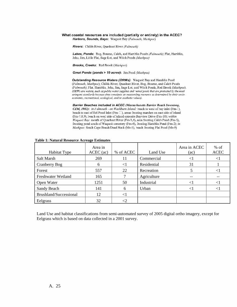
Table 1: Natural Resource Acreage Estimates
Habitat Type Area in
ACEC (ac) % of ACEC Land Use Area in ACEC
(ac) % of
ACEC Salt Marsh 269 11 Commercial <1 <1 Cranberry Bog 6 <1 Residential 31 1 Forest 557 22 Recreation 5 <1 Freshwater Wetland 165 7 Agriculture -- -- Open Water 1251 50 Industrial <1 <1 Sandy Beach 141 6 Urban <1 <1 Brushland/Successional 12 <1 Eelgrass 32 <2
Land Use and habitat classifications from semi-automated survey of 2005 digital ortho imagery, except for Eelgrass which is based on data collected in a 2001 survey.
A. 25

Appendix F Laws and Regulations In addition to the landscape designations and overlays, a variety of existing local, state, and Federal laws and regulations protect natural resources within the Reserve. These policies are summarized below. Reserve staff remains cognizant of regulatory restrictions and management policies and enforce those for which the Reserve has authority to do so and work with state and local law enforcement personnel to enforce others, especially those regarding the Waquoit Bay Area of Critical Environmental Concern. Areas of Critical Environmental Concern Waquoit Bay and some surrounding uplands were designated as an Area of Critical Environmental Concern (ACEC) in 1979 (See Appendix E for description and map of WBNERR ACEC).
Regulations with Stricter Standards within ACECs
Massachusetts Environmental Policy Act (MGL c. 30, ss. 61-62H and 301 CMR 11.00) MEPA ensures that proponents study alternatives to proposed actions and avoid, minimize, and mitigate environmental impacts of proposed actions. MEPA review is not a permitting process, but rather it is an information-gathering process that precedes final action by state permitting agencies. Projects located within ACECs subject to MEPA jurisdiction require closer scrutiny than projects located outside of ACECs (301 CMR 11.03(11)). That is, the review threshold of projects that require the filing of an Environmental Notification Form (ENF) is reduced for projects located within an ACEC. Public Waterfront Act (MGL c. 91 and 310 CMR 9.00) Commonly known as Chapter 91 and administered by the Department of Environmental Protection, this law protects the public's rights to access the waterfront for use and enjoyment of waterways of the Commonwealth, and codifies the Massachusetts version of the Public Trust Doctrine into statute. The Waterways regulations do not allow new fill in ACECs and place increased limits on new structures within ACECs (sections 9.32(1)(e) and 9.32(2)(d)). Proposed, new, privately owned structures for water-dependent use below the high-water mark, such as private docks or piers, are only eligible for a license provided that such structures are consistent with an ACEC resource Management Plan adopted by the municipality and approved by the Secretary of Environmental Affairs. Improvement (new) dredging is prohibited within an ACEC, except for the sole purpose of fisheries and wildlife enhancement. Maintenance dredging remains eligible for a permit. The disposal of dredged material is prohibited within an ACEC except for the purposes of beach nourishment, dune construction or stabilization with proper
A. 26

vegetative cover, or the enhancement of fisheries or wildlife resources (section 9.40(1)(b)). Wetlands Protection Act (MGL c. 131, s. 40 and 310 CMR 10.00) The Act is administered by local Conservation Commissions and DEP and ensures protection of wetland resources, including all coastal areas between Mean High Water and the limits of the Territorial Sea. This includes the Reserve’s Buffer areas (Figure 4), which although not under direct control of the Reserve, are protected by this Act. The regulations require avoidance, minimization, and mitigation of impacts (including impacts to aquatic vegetation, flood control, and fisheries and wildlife habitat), and establish performance standards that define levels of impact that a project cannot exceed. For coastal resource areas within ACECs, the performance standard is "no adverse effect" on the interests of the Act, except for maintenance dredging for navigational purposes of "Land Under the Ocean" (sec. 10.24 (5) (b)). A higher performance standard also applies to the inland (freshwater) wetlands resource areas known as "Bordering Vegetated Wetland (BVW)." Within an ACEC, potential projects are prohibited that would result in the loss of up to 5,000 square feet or, in some cases, in the loss of up to 500 square feet of BVW (310 CMR 10.55(4)(c)). This standard for BVW applies to all ACECs. Work affecting BVW may be permitted if it can be authorized under the "limited projects" section listed at 310 CMR 10.53(3). Massachusetts Coastal Zone Management (MCZM) Program Regulations (310 CMR 21.00) The MCZM regulations call for all appropriate EOEA agencies to preserve, restore and enhance complexes of coastal resources of regional or statewide significance through the ACEC Program. State and federal coastal zone regulations stipulate that any federal activity affecting the coastal zone must be consistent with MCZM's policies to the maximum extent practicable. As such, any project proposed in an ACEC that requires a federal permit, is federally funded or is a direct federal action is subject to review by MCZM before the federal activity can take place. Solid Waste Facilities Site Assignment Regulations (310 CMR 16.00) The Solid Waste Siting regulations prohibit the siting of new solid waste facilities within an ACEC (section 16.40(4)(d)). The regulations also prohibit the siting of such a facility located adjacent to an ACEC if such a siting "would fail to protect the outstanding resources of an ACEC."
State and Federal Endangered Species Act: The state’s Endangered Species Act (M.G.L. c. 131A and 321 CMR 8:00, 321 CMR 10:00) provides for listing endangered or threatened species or species of concern, and of their habitat. Once listed, the Act prohibits the taking, possession, transport, export, processing, sale or purchase of such species and any other species listed under the Federal Endangered Species Act. The Act prohibits any alteration of significant habitat of any protected species that may reduce the viability of the habitat. The Act is administered
A. 27
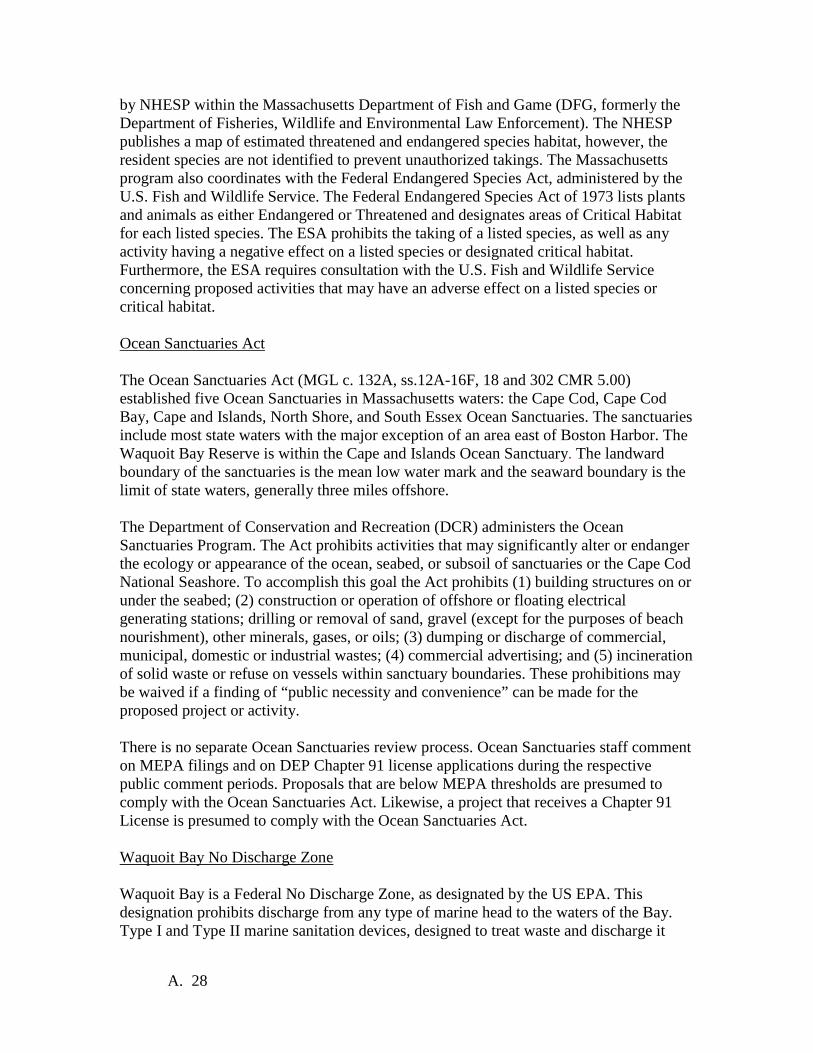
by NHESP within the Massachusetts Department of Fish and Game (DFG, formerly the Department of Fisheries, Wildlife and Environmental Law Enforcement). The NHESP publishes a map of estimated threatened and endangered species habitat, however, the resident species are not identified to prevent unauthorized takings. The Massachusetts program also coordinates with the Federal Endangered Species Act, administered by the U.S. Fish and Wildlife Service. The Federal Endangered Species Act of 1973 lists plants and animals as either Endangered or Threatened and designates areas of Critical Habitat for each listed species. The ESA prohibits the taking of a listed species, as well as any activity having a negative effect on a listed species or designated critical habitat. Furthermore, the ESA requires consultation with the U.S. Fish and Wildlife Service concerning proposed activities that may have an adverse effect on a listed species or critical habitat. Ocean Sanctuaries Act The Ocean Sanctuaries Act (MGL c. 132A, ss.12A-16F, 18 and 302 CMR 5.00) established five Ocean Sanctuaries in Massachusetts waters: the Cape Cod, Cape Cod Bay, Cape and Islands, North Shore, and South Essex Ocean Sanctuaries. The sanctuaries include most state waters with the major exception of an area east of Boston Harbor. The Waquoit Bay Reserve is within the Cape and Islands Ocean Sanctuary. The landward boundary of the sanctuaries is the mean low water mark and the seaward boundary is the limit of state waters, generally three miles offshore. The Department of Conservation and Recreation (DCR) administers the Ocean Sanctuaries Program. The Act prohibits activities that may significantly alter or endanger the ecology or appearance of the ocean, seabed, or subsoil of sanctuaries or the Cape Cod National Seashore. To accomplish this goal the Act prohibits (1) building structures on or under the seabed; (2) construction or operation of offshore or floating electrical generating stations; drilling or removal of sand, gravel (except for the purposes of beach nourishment), other minerals, gases, or oils; (3) dumping or discharge of commercial, municipal, domestic or industrial wastes; (4) commercial advertising; and (5) incineration of solid waste or refuse on vessels within sanctuary boundaries. These prohibitions may be waived if a finding of “public necessity and convenience” can be made for the proposed project or activity. There is no separate Ocean Sanctuaries review process. Ocean Sanctuaries staff comment on MEPA filings and on DEP Chapter 91 license applications during the respective public comment periods. Proposals that are below MEPA thresholds are presumed to comply with the Ocean Sanctuaries Act. Likewise, a project that receives a Chapter 91 License is presumed to comply with the Ocean Sanctuaries Act. Waquoit Bay No Discharge Zone Waquoit Bay is a Federal No Discharge Zone, as designated by the US EPA. This designation prohibits discharge from any type of marine head to the waters of the Bay. Type I and Type II marine sanitation devices, designed to treat waste and discharge it
A. 28

overboard, cannot be discharged in the Bay. Any waste generated must be retained and either pumped out to a system that ultimately discharges to an approved land-based treatment system or taken out of the Bay for discharge. Type III marine sanitation devices include holding tanks, incinerating devices, and recirculating devices; none of these can legally discharge any material into the Bay. It is, of course, illegal to discharge raw sewage to the Territorial Sea or any inland waterbody. Two pump-out facilities are available in waters connected to Waquoit Bay. Bosun’s Marine has a dock-based facility on the Childs River in Falmouth. The Town of Mashpee operates a boat-based pump-out. Boaters can contact the Mashpee Harbor Master on VHS Channel 9 on Sundays for free pumpouts in Waquoit and Popponesett Bays. It is available dockside at other times at the town dock on Little River. The pumpout boat is in the water until Columbus Day. Waquoit National Historic District The Waquoit National Historic District was listed in the National Register of Historic Places on February 26, 2004. The Reserve’s Headquarters Site is located within the Historic District which is roughly bounded by the Childs River, Carriage Shop Rd., Waquoit Hwy., Moonakis River, Moonakis Rd., Waquoit Bay, and Waquoit Landing. Listing in the National Register provides formal recognition of a property’s significance and makes the property eligible for preservation restrictions and provides limited protection from federally funded, licensed or assisted projects. The district is significant as an isolated Falmouth Village that reached the high point of its development in the 1850s with industrial, marine, agricultural, and summer tourism components. Because of the National Historic District designation, the historic Shingle Style main house and boat house and other existing outbuildings must continue to look as they do. The Cape Cod Commission, a regional planning body, will review proposals for substantial and detrimental alterations to, or demolition of, existing structures. New buildings on site are not subject to Cape Cod Commission Review. They are, however, subject to review by the Falmouth Historical Commission. Any new construction must be located in places that do not obstruct the existing views of the ca. 1900 estate and its buildings. Other State Regulatory Requirements Specific to DCR-Owned Lands Rules governing all Forests and Parks and the public's use of these lands are regulated by 304 CMR 12, an outline of which follows.
304 CMR 12.00: FORESTS AND PARKS RULES
Section
12.01: General Provisions 12.02: Definitions 12.03: Hours of Operations
A. 29

12.04: Public Behavior, Disorderly Conduct and Removal of Persons 12.05: Enforcement 12.06: Alcoholic Beverages Prohibited 12.07: Audio or Noise Producing Devices 12.08: Animals on Division Properties 12.09: Seeing Eye and Medical Support Dogs Allowed 12.10: Dumping, Littering, and Garbage 12.11: Damage to Buildings, Signs and Other Property; Metal Detectors; Geological Features
and Artifacts 12.12: Solicitation and Commercial Use 12.13: Fires, Lighted Smoking Materials, Embers 12.14: Smoking in Department Buildings Prohibited 12.15: Technical Climbing 12.16: Free Flight Devices 12.17: Special Use Permits 12.18: Hunting Fishing and Trapping 12.19: Target Shooting 12.20: Field Trials 12.21: Use of Non-Motorized Vehicles 12.22: Facilities Fees 12.23: Traffic Rules and Parking 12.24: Designated Campsites: General Rules 12.25: Designated Campsite or Cabin Visitors 12.26: Campsite Overflow Areas 12.27: Group Campsites, Safari Sites and Day Use Sites 12.28: Trail Use, General Provisions 12.29: Snow Vehicle and Off-Road Vehicle Operation 12.30: Trail Use, Bicycle Paths and Rail Trails 12.31: Use of Appalachian Trail 12.32: Use of Division Water Bodies including Beaches 12.33: Swimming Pools 12.34: Boating/Watercraft 12.35: Windsurfing 12.36: Board Surfing 12.37: Towing Behind Boats 12.38: Private Use of Division Waters
To summarize a few points relevant to the Reserve:
• No person shall bring a dog, cat or other animal into any State Forest, Park or Reservation except in areas and under conditions determined by the Director of the Division of Forests and Parks (304 CMR 12.08). For WBNERR, this means that dogs are allowed on leashes in most areas. However, they are not permitted on the public swimming beaches at South Cape Beach State Park or in piping plover nesting areas from April 1 to September 30.
• Littering is prohibited (304 CMR 12.10). • A person shall not damage or remove any Department property real or personal
(304 CMR 12.11). • No person shall launch or use any internal combustion powered watercraft of any
nature or type on Division waters were it is posted as prohibited (as it is on all Reserve Ponds) (304 CMR 12.34).
A. 30

Appendix G Non-SWMP Monitoring Programs 1. BayWatchers – BayWatchers is a volunteer Citizen Water Quality Monitoring group
based in Waquoit Bay and begun in 1993. Each of the 8 sites throughout the Reserve is measured for dissolved oxygen, salinity, temperature (air and water), water clarity (secchi depth), chlorophyll and nutrients. All sites are monitored once a month in the winter and twice a month in the summer.
2. CoastWatchers – CoastWatchers is another group staffed by volunteers. They measure shoreline change on the 3 miles of Waquoit Bay NERR’s Vineyard Sound-facing coastline. Since October 2000, linear and profile measurements have been taken of South Cape Beach and Washburn Island every 2 months from October through April.
3. Threatened/Endangered Species – Threatened and endangered species are present throughout the Reserve. Every spring, Piping Plovers (Charadrius melodus) appear on the beaches of Washburn Island, South Cape Beach, and neighboring New Seabury. The Reserve’s seasonal Shorebird Manager and trained volunteers monitor the beaches and erect symbolic fencing to protect the Plovers. Other monitored species include the Roseate Tern, Least Tern, Common Tern, Willets, and American Oyster Catchers. Monitoring programs are also in place for rare, endangered or state listed plants, including Northern Blazing Star (Liatris borealis) and Sandplain Gerardia (Agalinus acuta).
4. USGS Stream Gauge program – Quashnet River: USGS and other federal and state agencies monitor stream/river flow throughout the US using stream gauges. The data has a high importance for all water resource managers as well as emergency managers in case of flood conditions. Data on Quashnet River flow - the largest freshwater input into Waquoit Bay - is highly valuable environmental information for WBNERR researchers. The Quashnet River gauge is currently the only one on Cape Cod. While this program is not operated by WBNERR, it is located within the Reserve and on Reserve land, and monitors the Reserve’s most important fresh water stream. Due to budget cutbacks, there have attempts, in the past, to eliminate this important station from the program. This and the SWMP programs are both part of the National Hydrometeorological Data System. WBNERR has high interest in seeing this important monitoring program maintained.
5. River Instream Flow Stewards (RIFLS): Managed by the MA Division of Ecological Restoration (DER) (formerly Riverways). RIFLS is a program that enables local groups to learn about the importance of healthy streamflow, document streamflow on otherwise un-gauged rivers and restore more natural flow regimes in rivers suffering from abnormal flow alterations. Streamflow data are essential in determining suitability of rivers for fish restoration, specifically sea-run brook trout and river herring. WBNERR cooperates with DER, Falmouth Rod and Gun Club, and Department of Fish and Wildlife. To monitor a gauge they installed on the Childs River. ( http://www.rifls.org/detail.asp?siteId=64)
6. Horseshoe Crab spawning survey: Horseshoe crabs are counted in a known spawning area during the full and new-moon high tides in May and June as part of a regional effort to characterize the spawning population and to summarize a relative
A. 31

spawning index over time for the species. The survey was started in response to concerns that HSC populations may be declining due to habitat loss and harvest pressure. Our survey is one of many state and New England-wide. The MA Division of Marine Fisheries compiles data from Massachusetts to assess trends in the spawning population and inform management decisions See: http://www.mass.gov/dfwele/dmf/programsandprojects/horseshoe_crab.htm#hcrab
7. Nekton (free-swimming fish, crabs, and shrimp): In 2007, an area of salt marsh was restored at South Cape Beach by opening up a culvert and restoring tidal flow to an area that had been choked off from the ocean. This survey is designed to examine similarities and differences in the nekton communities in the restored marsh and a similar, natural marsh nearby to see if the restored area starts to function like a natural marsh.
8. Breeding birds: Birds are commonly used as sensitive environmental indicators. While, birds are only one of several types of organisms that inhabit salt marshes, they can yield insight that may be overlooked by studying only plants, invertebrates or fish. In 2000, the Reserve launched a volunteer-based effort to monitor the populations of breeding birds in three areas of the Reserve; the Quashnet River, Abigail’s Brook and Sage Lot Pond. Monitoring the population of breeding birds over time can give managers information on changes in vegetation, prey abundance, predation pressure, and changing climate.
9. Osprey: Like many raptors, this once-endangered bird has made a spectacular comeback since banning the pesticide DDT. A total of 37 osprey nest sites have been located in the areas around Waquoit Bay and mapped using GPS coordinates. The occupied sites are visited once monthly from April through Aug/ September by staff and volunteers to record activity and document the number of chicks fledged from each nest. In 2011, the project also included the repair of several nesting platforms. WBNERR’s data is incorporated into regional nesting data compiled by Mass Audubon Society.
10. New England Cottontail rabbit: This native species is separate from the introduced Eastern Cottontail rabbits typically seen in open areas.New England Cottontails need dense underbrush to survive. As forests mature and shade out brush, or land is cleared for housing, this habitat has become increasingly rare, resulting in a disappearance of these rabbits from 86% of their former range. In an effort to keep it off the endangered species list, US Fish and Wildlife Service is documenting species occurrence, population estimates, and recovery efforts. Cape Cod and especially Mashpee (including Reserve land at South Cape Beach) contain some of the largest populations of the species in New England. Monitoring consists of trapping, tagging, collaring, and tracking individual rabbits. It also includes pellet collection and DNA analysis for species identification. Field work is done primarily in the winter.( http://www.fws.gov/northeast/indepth/rabbit/index.html)
11. Trout: Brook trout are the only trout native to eastern North America and are considered an indicator species because they are sensitive to change in the environment. Historically very common in this region, the brook trout is now classified as “reduced”, “greatly reduced” or “extirpated” from its original home waters in eastern Massachusetts, which is indicative of the degree of modification to their original habitats. Together with MA Fish and Game and Trout Unlimited, we
A. 32
track movement of tagged fish throughout the watershed. Animal tagging studies help us understand individual movement behaviors, the size of home ranges, migration patterns, habitat usage, and population characteristics. Understanding these factors can inform conservation decisions pertaining to many species, but is particularly important when dealing with anadromous fish, such as sea-run brook trout, because of their complex life histories. (http://www.capecodtu.org/QUASHNET_RESTORATION.html)
12. Fish survey: The Massachusetts Division of Marine Fisheries (MDMF) has carried out an annual seine (net) survey in six Cape Cod estuaries (including Waquoit Bay) since the mid-1970s with the primary mission of assessing the new young-of-the-year winter flounder population. The results are used to assess how this valuable commercial and recreational species is doing. While carrying out this regular survey, MDMF has also recorded detailed data on a number of other species as well including Blue Crab and Green Crab. Interestingly this database spans a period of notable habitat decline, particularly a major reduction in eelgrass, within most of these Cape Cod estuaries. The dataset represents the longest, most detailed, and most rigorously maintained biological record of estuarine species for Cape Cod.
A. 33

Appendix H KEEP Implementation Plan K-12 Estuary Education Program Goals:
1. Teachers and students will have the knowledge, appreciation and skills to act as stewards of estuarine resources.
2. An increasing number of teachers and environmental educators on Cape Cod and Massachusetts will use NERRS science education products and programs.
Objectives: Teachers and students will . . .
1. Understand estuarine environments, coastal watersheds, coastal management issues, and their own role as stewards of the environment
2. Use NERRS science to consciously act in promoting the health of estuaries
3. Understand and use data streams for furthering the protection of estuaries.
4. Value the NERRS and support our mission.
5. Infuse NERRS science into formal education venues.
Operating Principles:
1. Most importantly, KEEP will include field-based estuarine science
2. KEEP programs implemented at Reserves, will be aligned with State and local agendas.
3. Inquiry based learning will be emphasized.
4. Well-defined evaluation strategies will be coordinated nationally to measure the
overall effectiveness of the program.
5. Clear learning objectives will guide the implementation of all KEEP programs.
A. 34

6. KEEP programs will use a variety of delivery modes to reach different learning styles
and will be creative and innovative in the use of technology.
Waquoit Bay Reserve K-12 Estuary Education Program Action Plan
The Waquoit Bay NERR recently completed a needs assessment of teachers who teach science on Cape Cod. The survey showed that more than two-thirds of respondents have received no training related to estuaries, watersheds, and the ocean in the last three years. When asked what was needed to support their teaching, the highest ranked highly needed choice was professional development. It also revealed that 91% of respondents want to include more outdoor education activities into their classes. When asked what help they need to accomplish that, 75% stated they would like professional development on conducting field experiences. These results indicate a high need for professional development in conducting field experiences with students.
How can we institutionalize estuary/watershed education in Cape Cod school districts? o Gather final piece of information on which districts require
estuary/watershed education and where it fits for them o Advertise programs in terms of STEM and A Framework for K-12 Science
Education: Practices, Crosscutting Concepts, and Core Ideas o Develop relationships with curriculum directors to provide both staff
training and student programs for whole grade levels in districts. o Offer a range of products to appeal to those willing to commit a large
amount of time and effort to topic as well as those who need to start with smaller commitments of time.
Web-based: • Promote www.estuaries.noaa.gov and Education section of WBNERR website • Add content to Education section of WBNERR website (and submit for possible
inclusion to estuaries.gov) o State Framework alignments and National Framework alignments o Lesson Plans, data activities o Resources available to teachers o Upcoming workshops o Pre and post activities o Post student stewardship projects (picture and caption) o Links to CTP and research resources for background information
Student Programs: • Continue to place emphasis on Habitat (ecosystems) and Water quality • Add more emphasis on Sea Level Rise/Coastal Impacts of Climate Change • Continue current programs that are integrated into school districts (Falmouth
Grade 6, and 8, DY Grade 6, Mashpee Grade 5) • Add districts and individual classes as funding/staffing become available with an
emphasis on whole grades in a district and underserved audiences (sliding scale) • Continue policy of grade 4 or up and customizing to participant’s curriculum
needs (refer lower grades to other organizations unless underserved audience)
A. 35

• Add pre and post field experience activities • Require pre-trip after school session (at school) for all teachers who are going on
field experience (introduce pre and post activities, expectations for field experience)
• Develop self-guided programs for teachers to bring classes to South Cape Beach on their own. Offer training for teachers before they come.
• Consider adding internship/mentorship program for high school students to work with individual researchers at Waquoit Bay Reserve (researchers write up need, Joan sends out to teachers on WBNERR’s e-list, teachers recommend appropriate students) Endorsed by teachers on Advisory committee as highly desireable- may have some logistical problems to work out (liability issues) and staffing (may need to write grant to hire coordinator or collaborate with WHSTEP)
Teacher Programs • Continue to place emphasis on Habitat (ecosystems), Coastal Impacts of Climate
Change/Sea Level Rise, and Water quality • Develop TOTE into 3 credit, yearlong course (ending in May). • Pre-service teacher training
o Contact nearby colleges o Try to get embedded into STEM or science methods courses. Offer to
guest teach one class session at the college (way to introduce both students and professors to NERRS/NOAA resources). Invite the professor to use WBNERR as field trip site.
• Get on the schedule for in service days at the schools o Contact Cape Cod Collaborative to partner for Cape-wide professional
development day o Work with schools to get on in-service training days in school districts
• Make mini presentations at faculty meetings after school: Contact all schools and ask to visit a department meeting (likely science, then math). Give short presentation to present about
• Websites (www.estuaries.noaa.gov , www.waquoitbayreserve.org ) • How estuary/watershed education relates to State and new National
Frameworks • Upcoming WBNERR professional development workshops • Other resources available from WBNERR • Ask them how we could support getting more estuary and watershed
education into their school) • 1 credit workshops (need 12 contact hours- 2 days during school vacation).
Topics (taken from KEEP Needs Assessment): • Coastal Processes/Cape Cod geology/Sea level Rise and Coastal Impacts
of Climate Change • Estuary processes and values/Eutrophication/Nitrogen Cycle
o Day long workshops: Focus on one topic. Pick topics on combination of NA/focus groups and which researchers are good speakers. Could string two together for 1 credit, etc.
o Format: Week day, 9-3
A. 36

• Intro to topic by WBNERR educators. • Scientist presentation (Powerpoint, archive on website) • Classroom activities (break into 2 groups- primary and secondary)
• Hands-on (scientific concepts) • Web-based- data analysis
• Field-based experience • Visit study site with scientist • Do field activity that can be adapted for classroom
• Teacher debrief, sharing ideas on how to apply in classroom • Take home kit:
• If we can get grant: pieces of equipment, print out and laminate good graphics, supplies for activities in one place
• Section on website o Researcher’s presentation o Lesson plans for what we did o Good website links o Curriculum framework alignments o Graphics
o If they want credit or PDPs: • Write a reflection piece that includes your thoughts on:
• Scientific content of the workshop (personal reflection) • How you intend to incorporate what you learned into your
classroom • Alignments to state frameworks (for the subject you teach)
• Evaluation o Develop ways to evaluate website, student programs, teacher programs
• Website: • Count number of hits, • Ask Advisory Committee to evaluate and provide
suggestions after we work on it (they have already given input)
• Students: • Several performance measures are being kept for the
NERRS • Continue giving teachers a post visit satisfaction survey,
review and implement appropriate suggestions • At least 10% of students will be given pre and post visit test
on content (have been doing on paper- will move to keypad and possibly surveymonkey)
• Teachers • Various methods are used depending on length of program
o TOTE has post satisfaction survey, pre/post content survey, checklist for skills, lesson plan write up and write up stewardship project with students
A. 37
o One or two day workshops (will be created to fit workshop)
o Short faculty meeting presentations (keep track of how many teachers sign up for teacher e-mail list and/or attend workshops)
Special project: Salt Marsh Classroom: We plan to build infrastructure on the marsh to the west of the visitor center to be able to do everything that we will do at the bio-monitoring site at South Cape Beach except on a smaller and less expensive scale. There will be a boardwalk so we will reduce impacts while increasing access. The purpose of the educational salt marsh is:
• To provide a hands-on learning experience for students and teachers to better understand estuary ecology.
• To increase understanding of, and support for, estuary research and monitoring.
Focus all programs on habitat, water quality, and coastal impacts of climate change/ sea level rise
A. 38

Appendix I Waquoit Bay Reserve Public Access Plan Each year over 60,000 people visit the Waquoit Bay National Estuarine Research Reserve Headquarters Site, South Cape Beach State Park, Washburn Island, Quashnet Woods, other parcels of WBNERR property. Some come for the recreational opportunities that the Reserve provides, including camping, swimming, fishing and shellfishing, hiking, boating, and birding. Others come for more structured activities that are related to the Reserve's research and education programs. Activities are held or allowed at all components of the Reserve. Some rules and regulations are common to all components and are summarized above. Other rules are specific to particular components and are described below. Headquarters Site Reserve policy concerning public access to the Headquarters Site includes the following guidelines:
• The Headquarters Site is limited to passive recreational activities that do not compromise the mission or objectives of the Reserve.
• Outside groups may use the Headquarters Site as long as their mission and objectives are consistent with the Reserve's or if the Reserve provides an educational program as an integral part of their program.
• Access to the beach through the Headquarters Site for recreational use is
discouraged because of potential conflicts with research or education programs on the beach or in the water in front of the beach. As an attractive alternative, South Cape Beach State Park provides considerably more extensive beach facilities. Also, people with boats are welcome to use the beaches on Washburn Island.
• Limited access is provided to commercial and recreational shellfishers on a “straight to the resource” basis. That is, shellfishers are allowed to use some of the limited parking spaces at the Headquarters Site during regular operating hours as long as there are no large events going on and as long as they pass through to the shellfishing area without lingering on the Reserve’s or abutters’ beaches.
• Public access to the research laboratory is limited to tours guided by Reserve staff members or volunteers. This policy protects both visitors and the integrity of the research work being done.
• Access to the endangered species management area is limited to Reserve staff members, researchers and volunteers working with this program. This directive protects the fragile plants in this management area.
South Cape Beach State Park The following policies and guidance balance the requirements of resource protection, research, and quality recreational experiences.
A. 39
• Swimming, sunbathing, fishing, hiking and birdwatching are the primary recreational uses of the beach area.
• No motorized boating access is provided at South Cape Beach State Park. There is a state-funded boat ramp on Great River accessed from Great Oak Road.
• Access is allowed on a year-to-year basis for hunting in season. Access for hunting is reassessed annually by WBNERR and the South Cape Beach Advisory Committee.
• Off-road vehicles are prohibited. Childs River While there are no official trails on the Childs River property, the public is permitted to hike and explore. Regulations guiding usage are posted on signs at the property’s boundaries. Abigail Brook The Abigail Brook property has an existing public trail that is maintained by volunteers. Regulations guiding usage are posted on signs at the property’s boundaries. Enforcement Most permanent and seasonal staff are trained to educate visitors about relevant rules and regulations. They are not, however, trained in, nor authorized to carry out, law enforcement activities. Rather, they are expected to report unlawful behavior to the appropriate personnel or outside law enforcement officials. Environmental Police Officers (EPOs) are responsible for enforcement of the Department’s rules and regulations on DCR properties, searching for lost or missing persons, and assisting the Massachusetts Bureau of Forest Fire Control as needed. Park Rangers can invoke the non-criminal citation process as necessary. The citation process may involve issuing fines or tickets for various infractions of DCR rules. The Forests and Parks Supervisor typically encounters incidents like illegal dumping, land encroachment, off-road vehicle use and illegal fire pits. Illegal dumping on Reserve property is a perennial problem. WBNERR staff will continue to identify illegal dumping during their routine patrols and, for both aesthetic and safety reasons, will collect the debris for proper disposal. Occasionally, an incident of a more serious nature occurs and restraint is used. Cooperation with police may result in an arrest at a DCR facility. The Reserve may call upon local police departments, Harbormasters, Natural Resource Officers, Massachusetts Environmental Police Officers and the U.S. Coast Guard for additional patrol, enforcement, and emergency response as necessary. All incidents must be reported to DCR through the formal incident reporting process.
A. 40

Appendix J WBNERR Land Acquisition Plan: 2014-2019 Introduction Purpose The WBNERR Land Acquisition Plan documents a strategy to acquire interest (fee simple or easement) in key land parcels in proximity to the Reserve boundary that provide one or more of the following values:
• Resource protection for terrestrial resources, • Resource protection for aquatic/estuarine resources, • Access for research, • Access for education programs, • Sites for stewardship demonstrations, • Locations for potential research/education facilities, and/or • Access for passive coastal recreation.
The Reserve will pursue acquisitions independently and in partnership with other organizations. Reserve acquisitions are covered by the NOAA OCRM 2005 Programmatic Environmental Assessment and Finding of No Significant Impact (PEA/FONSI) for the Coastal and Estuarine Land Conservation Program/Fish and Wildlife Conservation Act/National Estuarine Research Reserves (CELCP/FWCA/NERR) acquisitions. Overview of WBNERR Waquoit Bay National Estuarine Research Reserve, located in the towns of Falmouth and Mashpee in Massachusetts, was formally established in June 1998. It is composed of open waters, barrier beaches, sand dunes, fresh and salt marshes, rivers, and mixed pine and oak forests. The more than 2,700 acres of aquatic and terrestrial habitat in the Reserve are representative of the New England portion of the Virginian biogeographic province. The Reserve is guided by the following mission, vision, and goal statements:
Mission: To promote science-based decision-making that leads to healthy coastal ecosystems. Vision: To be a vital regional resource for expertise on sustainable coastal management.
A. 41

The Reserve’s goals are to:
1. Improve the understanding of coastal ecosystems and the human influences on them.
2. Improve environmental literacy in our communities to enable environmentally-sustainable decision-making.
3. Foster coastal ecosystem management solutions through sustained community
engagement.
4. Manage land and facilities in a manner that balances enjoyment by current generations with conservation for the future.
5. Improve the operations and stature of the Reserve.
The Reserve's primary activities are organized into three program areas: research and monitoring, training and education, and stewardship. All of the programs address the themes of water quality/eutrophication, climate change/renewable energy, and coastal ecosystem management. The program areas are supported by the Reserve's administrative and maintenance functions. Local Real Estate Market Cape Cod is one of the nation’s major resorts, located 75 miles from Boston and Providence and 250 miles from New York City. WBNERR is located in two towns, Falmouth and Mashpee, with roots dating back to the seventeenth century. Today, both towns are becoming increasingly developed. Undeveloped land in the area is rapidly disappearing as the once rural landscape becomes suburbanized. Developable parcels greater than 50 acres no longer exist in the vicinity of Waquoit Bay and its watershed. Most unprotected, undeveloped land remaining in the area is in parcels of two to ten acres and many of these pieces are already, or are in the process of being, subdivided. The decreasing regional supply of developable land makes land protection ever more important. The associated increase in land pricing, however, makes land protection ever more challenging. Waterfront and waterview land is almost entirely developed and remaining parcels are priced at a tremendous premium. Even inland of the water within the Waquoit Bay watershed, the demand for residential housing is driving up the price of undeveloped land. Recent market research indicates that neighborhood subdivisions with privacy and a high level of conformity support home prices in the range of $650,000 and above. The remaining undeveloped land parcels in the vicinity of the Reserve are currently highly vulnerable to this type of development. Additionally, the State of Massachusetts’ Comprehensive Permit Law (known as Chapter 40 B) which allows for a relaxation of local zoning restrictions when a proposed development includes affordability restrictions on 25% of its units, enables higher housing densities that, in turn, lead to higher land values.
A. 42

In the past, WBNERR has been integral in protecting large tracts of land threatened by conversion to residential developments. The Reserve's land preservation efforts have created the regionally unique environment that exists today for research, education, stewardship and recreation. WBNERR’s role in land acquisition is changing with the changing regional real estate market. There are few opportunities for large parcel protection that match the high profile successes of the past. A variety of opportunities exist, however, to protect important resource values and provide sites for enhanced research, education and stewardship activities through the acquisition of certain smaller parcels in the area. This plan describes the strategy for identifying parcels for acquisition by WBNERR. Community Involvement in Development of the Land Acquisition Plan WBNERR's land acquisition activities are guided by, and coordinated with, the land acquisition priorities of the Mashpee National Wildlife Refuge. The Refuge was established in 1995 by the U.S. Fish and Wildlife Service, through an act of Congress, to assure long-term protection of the unique and highly productive natural resources associated with the Waquoit Bay watershed. The authorizing legislation established a land acquisition boundary that includes 5,871 acres, the majority of which lie within the Waquoit Bay watershed. Also in 1995, the U.S. Fish and Wildlife Service developed a Land Protection Plan that prioritized all land parcels within the land acquisition boundary based on:
• Biological significance of the habitat for the protection of the Waquoit Bay watershed,
• Existing and potential development threats, • Continuity with other protected parcels within the Refuge, and • Availability of willing sellers.
Concurrent with establishment of the Reserve, eight Federal, state, local and private conservation organizations, including WBNERR, formed the Mashpee National Wildlife Refuge Conservation Partnership (MNWRCP). At the time of designation, 2,782 acres of land within the acquisition boundary were already protected by the organizations of the MNWR Partnership. Since 1995 the partners have protected approximately 1,400 additional acres of land within the acquisition boundary. WBNERR has gained title to several parcels and has facilitated the acquisition of land by partner organizations. In recent years WBNERR has focused all land acquisition activities toward parcels that are both within the MNWR land acquisition boundary and within the Waquoit Bay watershed boundary, and has worked closely with other MNWR partner organizations in planning, prioritizing and implementing land acquisitions. All of the new lands acquired by WBNERR during the past five years are within the MNWR land acquisition boundary. A Final Environmental Assessment of the MNWR (USFWS 1995) found “no significant impact” would result from the proposal to cooperatively preserve, protect, and manage lands within the towns of Mashpee and
A. 43
Falmouth. The proposal was developed by USFWS after extensive public input from citizens, elected officials, government agencies, and interested organizations. Existing Land Protection Tools A variety of excellent conservation planning tools currently exist to guide land protection in the State of Massachusetts. WBNERR and the Mashpee National Wildlife Refuge Conservation Partnership drew heavily upon the resources and policies of BioMap, Living Waters, the Massachusetts Statewide Land Conservation Plan (SLCP), and the Coastal and Estuarine Land Conservation (CELC) Plan when developing this land acquisition plan. • BioMap: BioMap, a program of the the Massachusetts Natural Heritage and
Endangered Species Program (NH&ESP), maintains and continually updates a series of maps depicting “Core Habitats” and “Supporting Natural Landscapes” critical for protecting biodiversity in Massachusetts. The maps are based on a long-term data base of rare plants, animals and natural communities in the state. The terrestrial “Core habitat” areas include multiple sites for 246 rare plant species, 129 rare animal species (vertebrates and invertebrates), and 92 natural community types.
• Living Waters: Living Waters, another MA NH&ESP effort, is intended to
compliment BioMap. Living Waters identifies the lakes, ponds, rivers and streams that should be the highest priority for freshwater biodiversity conservation in Massachusetts. Similar to BioMap, these special areas are referred to as “Core Habitats” and are comprised of the most important habitats for rare aquatic animals and plants and exemplary freshwater habitats. The Living Waters report also identifies the “Critical Supporting Watershed” for each of the freshwater “Core Habitats.” The Supporting Watersheds included the portion of the watershed that has the greatest potential to sustain or degrade the “Core Habitats”.
• Massachusetts Statewide Land Conservation Plan (SLCP): The Massachusetts
Statewide Land Conservation Plan (SLCP) was developed by a 33-member task force that was appointed by the Commonwealth’s Secretary of Environmental Affairs in the spring of 2001 and included all major state and regional land trusts, state and Federal conservation agencies, statewide watershed and conservation commission organizations, a regional planning agency, and a conservation foundation. The goal of the task force was to use existing statewide and regional plans and other data to develop a strategy that would protect the six major resource categories of the Commonwealth including: water resources, important habitat, working farms and forests, greenways, outdoor recreation sites, and urban parks. The plan includes specific acreage goals that should be protected by the partners and a discussion of the various tools that should be considered for conservation protection. Core Habitat and Supporting Natural Landscape areas identified in the BioMap project form a large component of the plan. Other areas were considered to have statewide or regional significance and in the Cape Cod region, were included in the SLCP if they were contained in three or more regional conservation planning
A. 44

efforts. Land acquisitions by Massachusetts state agencies, including DCR are guided by the SLCP.
• Coastal and Estuarine Land Conservation (CELC) Plan: In 2005, the
Massachusetts Office of Coastal Zone Management in cooperation with other state and Federal land management agencies, including the Department of Conservation and Recreation, developed a statewide Coastal and Estuarine Land Conservation (CELC) Plan. This plan was developed as a requirement to allow Massachusetts coastal land protection projects to be eligible for funding from NOAA’s Coastal and Estuarine Land Conservation Program (CELCP). This plan provides an assessment of priority conservation needs and clear guidance for nominating and selecting coastal and estuarine land conservation projects within the state. Land areas identified for protection in this plan are based on lands identified within the BioMap, Living Waters and the SLCP that occur in the coastal towns of Massachusetts. The CELC Plan does not include parcels from the SLCP that were valued solely for agricultural/ silvicultural values and gives parcels protective of drinking water resources equal importance to parcels protective of other resource values (SLCP gives twice the consideration to drinking water as to other resource values). Additional parcels were included in the CELCP for proximity to marine and estuarine shoreline (all parcels greater than three acres in size and within 2,000 feet of shoreline), for proximity to major surface water tributaries (all parcels greater than three acres in size within 1000 feet of a major tributary), and for proximity to regional trails (all parcels within 200 feet of an existing or proposed regional trail).
Resource Assessments Land Use Lands within the Stewardship Focus Area are primarily composed of upland pitch pine/oak forests, freshwater wetlands, kettle ponds and other habitats representative of the bioregion. Much of the forested open space in the watershed has been converted to low density single family home residential development (Figure 22). The towns of Falmouth, Mashpee and Sandwich lie within the Waquoit Bay watershed. These are some of the most rapidly growing towns in Massachusetts. Commercial and retail developments occur along Route 28 and Route 151. The Massachusetts Military Reservation, including a large airstrip and associated facilities, exists in the northern most portion of the watershed. A limited amount of land in the watershed is still used for cranberry agriculture. Rare, Threatened or Endangered Species A variety of state and federally listed protected species occur within the watershed (Figure 23). Archeological, Historical, and Cultural Resources
A. 45

The Waquoit Bay region is the ancestral and modern home of the Wampanoag Indians. There are, therefore, an abundance of significant archeological sites within both the Reserve Boundary and the SFA. Details about specific sites, including locations, are kept confidential because of the vulnerability of these irreplaceable resources. The information is maintained by the Massachusetts Historical Commission and the DCR Office of Cultural Resources. Such resource values should be considered in planning future land acquisition and protection activities. The Reserve’s headquarters are located within the Waquoit National Historic District (Figure 24). The Historic District was established in 2004 in recognition of the area’s significance as an isolated Falmouth Village that reached the high point of its development in the 1850s with industrial, marine, agricultural, and summer tourism components. The Historic District is roughly bounded by the Childs River, Carriage Shop Rd., Waquoit Hwy., Moonakis River, Moonakis Rd., Waquoit Bay, and Waquoit Landing. Figure 22: Land Use Change in the Waquoit Bay Watershed
A. 46

Figure 23: Rare Species Habitat
Figure 24: Waquoit National Historic District
A. 47
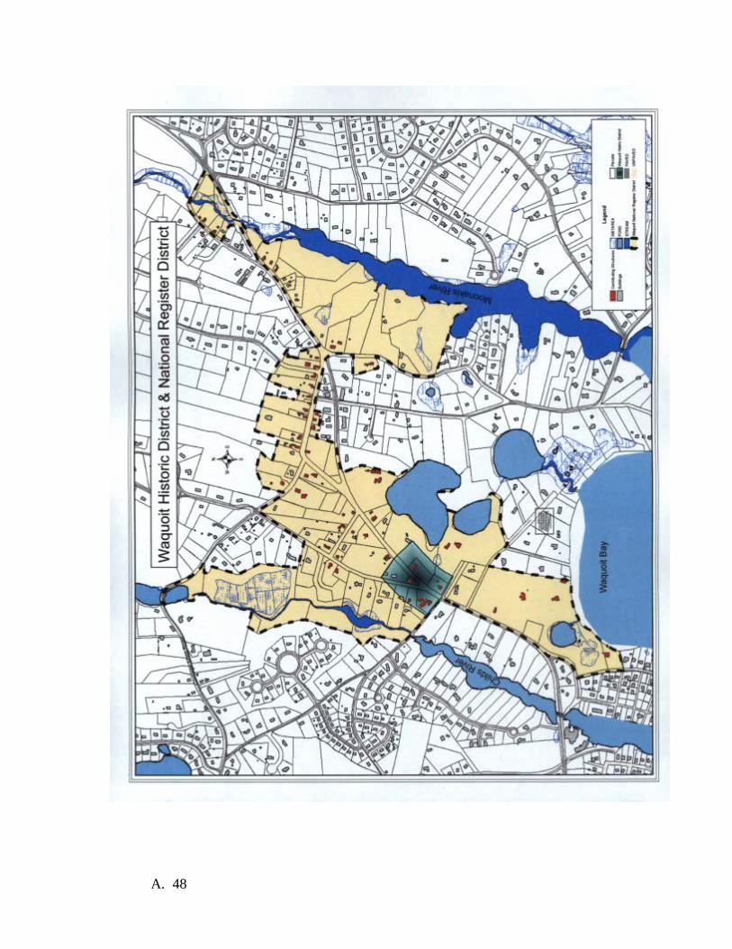
A. 48

Priority Land Types The following descriptors classify land types that exist within the SFA that are priorities for acquisition in order to advance the WBNERR mission.
• Shoreline: This category includes actual coastal shoreline on Nantucket Sound, the Waquoit Bay Estuarine System and its associated salt pond embayments and salt marshes, the estuary’s tributary rivers, and the kettle ponds of the watershed.
• Coastal habitats: This category includes any land within 2000 feet of a shoreline. These areas often contain important habitats and are critical to controlling non-point source nitrogen loading to surface waters.
• Rare/protected species and unique natural habitats: This category includes state identified coastal “core habitats” for listed species such as piping plover and least tern (which would also be included in “coastal habitat” above), but also includes “core habitat” areas for inland and freshwater species within the SFA which are also very important coastal resources needing protection.
• Contiguous large undisturbed habitats: This category includes parcels that abut or are adjacent to existing protected conservation lands. Such parcels can significantly build upon the values of the existing protected land by buffering existing protected habitats and providing large, unfragmented natural habitat areas for flora and fauna that require them. Preservation of large contiguous areas of undeveloped land is particularly important in the Waquoit Bay area on Cape Cod because development patterns in the region have made these unfragmented areas increasingly rare.
• Contributing watershed area: This category refers to any piece of land that drains to groundwater discharging into the Waquoit Bay estuary system. The waters of the Waquoit Bay estuary are highly affected by land derived pollutants, particularly nitrogen, moving to the Bay by groundwater and streams. Protecting watershed land can reduce pollutants from a variety of the most prominent sources. Also, natural habitats effectively intercept pollutants coming from outside sources, such as atmospheric deposition.
Priority Areas The following list describing WBNERR’s priorities for land acquisition, including land parcels within the Stewardship Focus Area that remain threatened with development. Working through the Mashpee National Wildlife Refuge Partnership, or alone, using established DCR land acquisition procedures, the Reserve will work to acquire these priority land parcels from willing sellers. Acquisition will occur with funds from NOAA, DCR, other grant sources, a combination of these or through donation. The Reserve will prioritize fee simple acquisitions, but will consider easements of the appropriate type on parcels where it will better suit the needs of the Reserve and the available funding. Individual properties are not given priority ranking because of the constantly changing market environment. Inclusion of valuable habitat, continuity with existing WBNERR land or water, continuity with other conservation lands, proximity to surface waters, and
A. 49

level of development threat are all considered along with development threat, market conditions and available funding when making specific land acquisition decisions. Possible partners for land acquisition include the Compact of Cape Cod Conservation Land Trusts and all of the members of the MNWR Conservation Partnership: United States Fish and Wildlife Service, MA Department of Fisheries and Wildlife, Town of Mashpee, Town of Falmouth, The 300 Committee, The Orenda Wildlife Land Trust, and Falmouth Rod and Gun Club. Individual parcel acquisition projects will include a variety of actions by WBNERR. Funding will be sought from state, Federal and other sources in order to acquire parcels within the areas identified in this plan. The possibility of real estate donations of parcels within the SFA will be investigated and donations will be accepted. The Reserve will continue to work with the MNWR partners to encourage creative land protection deals in the spirit of the three way land swap that resulted in the 2005 acquisition of the NStar parcel. Acquisition of conservation restrictions will be investigated as an alternative to full fee acquisition. When funding is not available to the Reserve, partner organizations will be encouraged and assisted in protecting lands within the SFA. Estuary Waterfront Reasons for acquisition: Undeveloped parcels in this area represent the few remaining unprotected, undeveloped land parcels that immediately abut the estuaries, tributaries or associated surface waters of the Waquoit Bay estuary ecosystem. Because of their proximity to the water these parcels are burdened with the highest risk of development. These parcels are unique and valuable for their proximity to the shoreline. The natural communities that they support, including fish, wildlife and vegetation resources are limited and vanishing resources in the Waquoit Bay area. These parcels also yield significant benefits to surface water quality in their undeveloped condition. Proximity to the water also gives these parcels very high value for Reserve research, education and stewardship activities. Some of these parcels could provide sites for waterfront research and education facilities. Land use regulations: The use of these undeveloped parcels is regulated by Falmouth and Mashpee bylaws. Land use is also subject to regulation under Massachusetts laws including the Massachusetts Environmental Policy Act (MGL c. 30, ss. 61-62H and 301 CMR 11.00), Public Waterfront Act (MGL c. 91 and 310 CMR 9.00), Wetlands Protection Act (MGL c. 131, s. 40 and 310 CMR 10.00), Massachusetts Coastal Zone Management (MCZM) Program Regulations (310 CMR 21.00), and State and Federal Endangered Species Act (M.G.L. c. 131A and 321 CMR 8:00, 321 CMR 10:00). How acquisition will further purpose and goals of Reserve: The acquisition of estuarine waterfront land will protect estuarine and surface water quality and natural communities. Acquisition will also allow access to the estuary and shoreline for research, education and stewardship activities. Additionally, some of these parcels could provide valuable public access for passive recreation.
A. 50

Post acquisition stewardship: Stewardship at each acquired parcel would be similar to stewardship at existing Reserve parcels and would likely include signage, surveillance, enforcement, and habitat protection and restoration. Potential partners: The organizations of the Mashpee National Wildlife Refuge conservation are possible partners for all land acquisition projects. Acquisition costs and future ownership: Full fee ownership is desirable for most parcels. Conservation restrictions on some of these parcels, however, could provide significant benefits if fee ownership is not negotiable due to limited funding or other reasons. Market values in the vicinity of the Reserve range from $200,000 to over $1 million per developable acre depending on proximity to waterfront. All interests, fee or otherwise, would be owned by the Commonwealth of Massachusetts. Central Watershed Reasons for acquisition: These key land parcels remain unprotected from development in an area where a very successful coordinated effort has protected large tracts of land. This area includes the subwatersheds for the Childs and Quashnet Rivers, the two largest tributary streams of the Waquoit Bay estuary system. Protection efforts by the partners of the Mashpee National Wildlife Refuge have had tremendous benefits in terms of protecting water quality in the estuary and natural habitat in and adjacent to the two streams, both of which are important anadromous fish runs. Development of any of these key parcels will contribute to nitrogen loading in the estuary and will undermine benefits of the proposed plan to protect large contiguous tracts of habitat anchored by the existing WBNERR Quashnet River Area and Childs River Area parcels. Each of these parcels has very high value for Reserve research, education and stewardship activities. Land use regulations: The use of these undeveloped parcels is regulated by Falmouth and Mashpee bylaws. Land use is also subject to regulation under Massachusetts laws including the Massachusetts Environmental Policy Act (MGL c. 30, ss. 61-62H and 301 CMR 11.00), Public Waterfront Act (MGL c. 91 and 310 CMR 9.00), Wetlands Protection Act (MGL c. 131, s. 40 and 310 CMR 10.00), Massachusetts Coastal Zone Management (MCZM) Program Regulations (310 CMR 21.00), and State and Federal Endangered Species Act (M.G.L. c. 131A and 321 CMR 8:00, 321 CMR 10:00). How acquisition will further purpose and goals of Reserve: Acquisition of parcels in the central watershed will protect estuarine and surface water quality and natural communities. Acquisition would also protect significant tracts of undisturbed natural habitat important for some research, education and stewardship activities. Some of these parcels could also provide valuable public access for passive recreation. Post acquisition stewardship: Stewardship at each acquired parcel would be similar to stewardship at existing Reserve parcels and would likely include signage, surveillance, enforcement, and habitat protection and restoration.
A. 51

Potential partners: The organizations of the Mashpee National Wildlife Refuge conservation are possible partners for all land acquisition projects. Acquisition costs and future ownership: Full fee ownership is desirable for most parcels. Conservation restrictions on some of these parcels, however, could provide significant benefits if fee ownership is not negotiable due to limited funding or other reasons. Market values in the vicinity of the Reserve range from $200,000 to over $1 million per developable acre depending on proximity to waterfront. All interests, fee or otherwise, would be owned by the Commonwealth of Massachusetts. East Reserve Reasons for acquisition: These key land parcels remain unprotected from development in an area where a very successful coordinated effort has protected large tracts of land. This area includes the subwatershed for Jehu Pond, one of the few remaining areas containing eel grass habitat in the Waquoit Bay estuary system. WBNERR’s Abigail Brook area is in this vicinity and some of these priority parcels would protect the upper portion of Abigail Brook’s watershed and area with high potential for habitat restoration research and demonstration projects. Protection of each of these parcels has very high value for Reserve research, education and stewardship activities and would help to limit nitrogen loading. Land use regulations: The use of these undeveloped parcels is regulated by Mashpee bylaws. Land use is also subject to regulation under Massachusetts laws including the Massachusetts Environmental Policy Act (MGL c. 30, ss. 61-62H and 301 CMR 11.00), Public Waterfront Act (MGL c. 91 and 310 CMR 9.00), Wetlands Protection Act (MGL c. 131, s. 40 and 310 CMR 10.00), Massachusetts Coastal Zone Management (MCZM) Program Regulations (310 CMR 21.00), and State and Federal Endangered Species Act (M.G.L. c. 131A and 321 CMR 8:00, 321 CMR 10:00). How acquisition will further purpose and goals of Reserve: Acquisition of parcels in the east watershed will protect estuarine and surface water quality and natural communities. Acquisition would also protect significant tracts of undisturbed natural habitat important for some research, education and stewardship activities. Some of these parcels could also provide valuable public access for passive recreation. Post acquisition stewardship: Stewardship at each acquired parcel would be similar to stewardship at existing Reserve parcels and would likely include signage, surveillance, enforcement, and habitat protection and restoration. Potential partners: The organizations of the Mashpee National Wildlife Refuge conservation are possible partners for all land acquisition projects. Acquisition costs and future ownership: Full fee ownership is desirable for most parcels. Conservation restrictions on some of these parcels, however, could provide significant
A. 52
benefits if fee ownership is not negotiable due to limited funding or other reasons. Market values in the vicinity of the Reserve range from $200,000 to over $1 million per developable acre depending on proximity to waterfront. All interests, fee or otherwise, would be owned by the Commonwealth of Massachusetts. Northern Watershed Reasons for acquisition: These parcels fall within the land acquisition boundary of the Mashpee National Wildlife Refuge in the northern part of the Waquoit Bay watershed. Protection of these parcels would limit nitrogen loading associated with land development to the Quashnet River and the estuaries. Protection of these parcels will also contribute to protection of large contiguous parcels of natural habitat that are important for some Reserve research, education and stewardship activities. Land use regulations: The use of these undeveloped parcels is regulated by Falmouth and Sandwich bylaws. Land use is also subject to regulation under Massachusetts laws including the Massachusetts Environmental Policy Act (MGL c. 30, ss. 61-62H and 301 CMR 11.00), Public Waterfront Act (MGL c. 91 and 310 CMR 9.00), Wetlands Protection Act (MGL c. 131, s. 40 and 310 CMR 10.00), Massachusetts Coastal Zone Management (MCZM) Program Regulations (310 CMR 21.00), and State and Federal Endangered Species Act (M.G.L. c. 131A and 321 CMR 8:00, 321 CMR 10:00. Some parcels in this area are also subject to military aviation easements. How acquisition will further purpose and goals of Reserve: Acquisition of parcels in the northern watershed will protect estuarine and surface water quality and natural communities. Acquisition would also protect significant tracts of undisturbed natural habitat important for some research, education and stewardship activities. Some of these parcels could also provide valuable public access for passive recreation. Post acquisition stewardship: Stewardship at each acquired parcel would be similar to stewardship at existing Reserve parcels and would likely include signage, surveillance, enforcement, and habitat protection and restoration. Potential partners: The organizations of the Mashpee National Wildlife Refuge conservation are possible partners for all land acquisition projects. Acquisition costs and future ownership: Full fee ownership is desirable for most parcels. Conservation restrictions on some of these parcels, however, could provide significant benefits if fee ownership is not negotiable due to limited funding or other reasons. Market values in the vicinity of the Reserve range from $200,000 to over $1 million per developable acre depending on proximity to waterfront. All interests, fee or otherwise, would be owned by the Commonwealth of Massachusetts.
A. 53

Appendix K MOU between NOAA and Massachusetts Department of Conservation and Recreation
A. 54

A. 55

A. 56

A. 57

A. 58

Appendix L MOU between the Town of Mashpee and the Commonwealth of Massachusetts regarding South Cape
Beach
A. 59

A. 60
A. 61

A. 62

A. 63

A. 64

Appendix M MOU Concerning Cooperation and Coordination with Regard to the Mashpee National Wildlife
Refuge
A. 65
A. 66
A. 67
A. 68

A. 69
Appendix N MOU Between DEM and DFW (Quashnet River Management)
A. 70

A. 71

Appendix O MOU between DCR and Waquoit Bay Reserve Foundation
MEMORANDUM OF AGREEMENT
BY AND BETWEEN THE WAQUOIT BAY RESERVE FOUNDATION
AND THE COMMONWEALTH OF MASSACHUSETTS
DEPARTMENT OF CONSERVATION AND RECREATION CONSIDERING PARTNERSHIP ACTIVITIES AT
WAQUOIT BAY NATIONAL ESTUARINE RESEARCH RESERVE (WBNERR) WAQUOIT, MA
PARTIES
The parties to this Memorandum of Agreement (hereinafter “Agreement”) are the Commonwealth of Massachusetts, Department of Conservation and Recreation, with a principal place of business located at 251 Causeway Street, Boston, Massachusetts 02114 (hereinafter “DCR”) and the Waquoit Bay Reserve Foundation Inc., with a mailing address of PO Box 3522, Waquoit, Massachusetts 02536 (hereinafter “WBRF”)
AUTHORITY The DCR is acting pursuant to the authority set forth in G. L. c. 132A, § 7, rules and regulations promulgated thereunder, including 304 Code Mass. Regs. § 12.00, and all other powers enabling.
PURPOSE The Waquoit Bay National Estuarine Research Reserve (WBNERR) is under the care, custody, and control of the DCR. DCR’s friends groups exist to work in close collaboration with the agency and other parks stakeholders to enhance DCR parklands, facilities and cultural properties by providing financial, programmatic and volunteer support. WBRF supports the mission of WBNERR by promoting the wise use of the natural and historic features of WBNERR in a manner consistent with its protection and preservation through the provision of educational, cultural, scientific, and civic activities of WBNERR. WBRF is also a recipient of a sub-award from the National Oceanic and Atmospheric Association (NOAA) for Education and Coastal Training Activities at WBNERR (Award Number: WAQ2012).
A. 72

TERM The term for the use authorized herein shall be for an initial period of not to exceed five (5) consecutive years commencing as of January 31, 2013 and expiring on December 31, 2018, unless terminated earlier in accordance with the terms of this agreement. This Agreement may be renewed for one or more additional five (5) year terms at the sole discretion of the DCR.
AGREEMENT WBRF hereby agrees that it shall:
1. Promote the wise use of the natural, historical and recreational resources of WBNERR through the support and provision of research, monitoring, stewardship, educational, interpretive, cultural and recreation programs and activities.
2. Attract and organize volunteer assistance and public involvement at the
WBNERR. Such volunteer activities will be in accordance with all DCR volunteer policies and procedures.
3. Solicit, receive, distribute, and administer grants and donations for funding of
research, monitoring, stewardship, education, interpretive, cultural, and recreational programs, activities, supplies and equipment related to WBNERR.
4. Operate any on-site concessions in accordance with DCR Long-Term Permit &
Lease permitting procedures, including advance approval in writing from the Long-Term Permit & Lease Program Manager, and from the DCR District, Regional, and/or MassParks Director(s).
5. Conduct programs and events on WBNERR property to accomplish the purposes
set forth herein, with prior approval of WBNERR.
The DCR hereby agrees that it shall allow the WBRF to:
1. perform the above activities and responsibilities; 2. sponsor and carry out special events at WBNERR, provided that events are
approved through the DCR’s Special Use Permit process; and 3. sponsor and perform repairs and improvements pre-approved in writing by DCR’s
Director of State Parks, Deputy Director of State Parks or the Director of the South Region.
A. 73

COMPLIANCE WITH LAWS WBRF hereby agrees to comply with and conform to all laws, rules, regulations, and policies of the DCR and those of all other applicable state, federal, and local agencies, authorities or bodies, including, but not limited to, G. L. c. 254, which requires approval by the Massachusetts Historical Commission before any work is commenced. The WBRF shall file for and obtain all necessary federal, state, and local permits, licenses, and certificates.
ACCESS AND INSPECTION DCR may provide storage space to WBRF if available. If WBRF maintains any locked containers, rooms, etc. on WBNERR property, copies of the keys or combinations will be provided to the Reserve Manager.
NON-TRANSFERABLE This agreement is not transferable and no privilege contained herein may be assigned, delegated, or sublet to any other person, entity, or organization.
NON-EXCLUSIVITY WBRF’s use of any facilities at WBNERR is not exclusive. The WBRF may only use the facitlies at WBNERR for the purposes authorized herein and shall be subject to the rules, regulations, and policies of the DCR and of the Commonwealth.
INSURANCE 1. WBRF shall maintain comprehensive general liability insurance on an occurrence basis insuring against all claims and demands against, and liability of WBRF and/or DCR for personal injury and property damage arising out of and in connection with WBNERR or WBRF’s use or occupancy of WBNERR, in standard form to afford protection in an amount not less than $1,000,000 combined single limit for personal and bodily injury and death, and for property damage, with a so-called “broad-form” endorsement, and a per-occurrence limit of not less than $1,000,000 bodily injury, property damage and medical payments, which may be based upon a combination of primary coverage (plus umbrella coverage), which policy shall include operations and blanket contractual liability coverage. 2. WBRF shall cause the DCR and Commonwealth of Massachusetts to be named as additional insured on all insurance policies and Certificates of Insurance and provide DCR with Certificates of Insurance by July 1 annually. 3. If the WBRF’s insurance provisions, terms, coverage, or similar are amended, changed, suspended, expired or cancelled in any fashion, the WBRF immediately must
A. 74

notify the DCR verbally and shall also notify the DCR in writing within five (5) business days. 4. The WBRF shall maintain said policies for the full term of operation. Failure to maintain all insurance coverage noted herein shall be deemed a material breach of the WBRF’s duties. 5. The WBRF shall carry insurance in the types and amounts as described in this section of the Permit Agreement at its own expense. 6. The WBRF shall furnish Certificates of Insurance issued by an insurer or insurers qualified to do business in the Commonwealth. Said Certificates of Insurance must be provided to the two (2) addresses listed below prior to execution of the agreement and by November 30th of each subsequent year of the agreement Term.
Department of Conservation and Recreation South Region
Attn: Karl Pastore, Regional Director 194 Cranberry Road Carver, MA 02366
508-728-9749
Department of Conservation and Recreation Office of Long-Term Permits and Leases
251 Causeway Street, Suite 600 Boston, Massachusetts 02114
7. Failure to furnish said Certificates of Insurance and policies shall be deemed a material breach of the WBRF’s duties under this agreement.
INDEMNIFICATION Unless otherwise exempted by law, the WBRF shall indemnify, defend, and hold harmless the Commonwealth, including the DCR, its agents, officers and employees against any and all claims, liabilities and costs for any personal injury or property damages, patent or copyright infringement or other damages that the Commonwealth may sustain which arise out of or in connection with the WBRF 's performance under the agreement, including but not limited to the negligence, reckless or intentional conduct of the WBRF, its agents, officers, employees or subcontractors, unless such claim arises solely from the negligence of the DCR, it employees, agents, or contractors. The WBRF shall at no time be considered an agent or representative of the DCR or the Commonwealth. The Commonwealth shall not be liable for any costs incurred by the WBRF arising under this paragraph.
A. 75

LEASED EQUIPMENT
The WBRF must identify all leased equipment to be used on the Premises prior to the execution of the agreement. The WBRF shall also notify the DCR in writing of any leased equipment brought onto the Premises after the execution of the awarded agreement. The WBRF shall be responsible for any obligation under such a lease. Any equipment, leased or otherwise, that is affixed in a permanent manner including but not limited to, plumbing fixtures, sinks, hard-wired appliances, built-in refrigeration equipment, or exhaust, fume, and fire suppression systems affixed to a wall or ceiling of the Premises shall immediately become the property of the DCR. This equipment shall be identified and agreed upon by both parties prior to the execution of the awarded agreement. At the termination of the agreement, the WBRF bears the sole responsibility for fulfilling any remaining obligations under the lease arrangement, financing agreements, security agreements, or similar so that title to this equipment can be passed directly to the Commonwealth prior to the WBRF vacating the Premises.
TERMINATION
1. The DCR may terminate the agreement at will or for cause or for any reason given at law or pursuant to any term or condition of this agreement with thirty (30) calendar days prior written notice to the WBRF. The WBRF may be granted the right to cure any condition, by curing such condition within forty eight (48) hours of receipt of notice. If the condition cannot be cured within forty eight (48) hours, WBRF must provide written notice that additional time is required, not to exceed fifteen (15) calendar days. 2. The WBRF may terminate the agreement at will or for cause or for any reason given at law or pursuant to any term or condition of this agreement with thirty (30) days prior written notice to DCR. 3. The WBRF hereby agrees that neglect or failure to perform any of its agreements or obligations under the agreement shall be cause for termination in accordance with this section and will peacefully surrender the property. 4. The WBRF hereby acknowledges the awarded agreement is a license and the DCR reserves the right to revoke said license at its sole discretion when determined by DCR to be in the public’s best interest.
MODIFICATIONS The terms of this agreement may not be modified, except by written agreement signed by both parties.
A. 76

SEVERABILITY If any part of this agreement is determined to be invalid, illegal, or unenforceable, such determination shall not affect the validity, legality, or enforceability of any other part of this agreement, and the remaining parts of this agreement shall be enforced as if such invalid, illegal, or unenforceable part were not contained herein.
MERGER CLAUSE The provisions of this agreement and any attachments shall collectively constitute the agreement between the parties for the use of the Premises. Any prior or contemporaneous oral or written statements that alter, contradict, or are in addition to the terms of this agreement or any attachments are inadmissible.
WAIVER No waiver by either party at any time of the terms, conditions or covenants of this agreement shall be deemed a waiver at any time thereafter of the same provision or of any other provision contained herein, or of the strict and prompt performance thereof.
NOTICE All notices provided pertaining to this agreement shall be sent in writing, by hand-delivery or postal mail, to the following representatives of the parties: DCR: Department of Conservation and Recreation Commissioner 251 Causeway Street, Suite 600 Boston, MA 02114 Department of Conservation and Recreation Priscilla Geigis Assistant Commissioner/Director of the Division of State Parks 251 Causeway Street, Suite 600 Boston, MA 02114 Department of Conservation and Recreation Office of the General Counsel 251 Causeway Street, Suite 600 Boston, MA 02114
A. 77

SIGNATORIES The parties herein have read the foregoing conditions and provisions and hereby voluntarily and cognizantly approve of and agree to these terms.
DEPARTMENT OF CONSERVATION AND RECREATION
______________________________________ Edward Lambert, Jr., Commissioner Department of Conservation and Recreation 251 Causeway Street Boston, Massachusetts 02114 Date: _______________________________
Waquoit Bay Reserve Foundation ______________________________________ Nathan B Higbie President [email protected] Date: _______________________________
A. 78
Appendix P Interdepartmental Service Agreement between Executive Office of Environmental Affairs (DCR) and the
University of Massachusetts, Boston
A. 79