walking trail study, village of brussels, … trail study, village of brussels, municipality of...
TRANSCRIPT
1
2012
PLAN 641/PLAN 414/REC 425, School of
Planning, University of Waterloo
Hewlett-Packard
4/1/2012
Walking Trail Study, Village of Brussels, Municipality of Huron East

2

PLAN 414/REC 425, School of Planning, University of Waterloo, 2012
3
Brussels Walking Trail Village of Brussels, Municipality of Huron East
Huron County
Prepared for The Village of Brussels, ON
By PLAN 414/REC 425, Heritage Workshop, School of Planning,
University of Waterloo, ON In cooperation with
The Heritage Resources Centre
Reviewed by Vanessa Hicks, B.A., M.A. (candidate)
University of Waterloo
APRIL 2012

PLAN 414/REC 425, School of Planning, University of Waterloo, 2012
4

PLAN 414/REC 425, School of Planning, University of Waterloo, 2012
5
April 30, 2012
Janice Hawley Economic Development Officer Municipality of Huron East 72 Main Street S POB 610 Seaforth ON N0K 1W0
Dear Jan:
Re: Village of Brussels Heritage Trail Student Project
In accordance with the January 2012 contracts between the Heritage Resources Centre, the County of Huron and the Township of Huron East, please find attached the subject project report.
It should be pointed out that the work contained in this report is based on student work carried out as part of a senior undergraduate course in Heritage Planning and Heritage Tourism which is an elective course in the School of Planning, University of Waterloo. While the work was supervised by me and the staff of the Heritage Resources Centre its primary role was a learning exercise and it is not offered as a professional undertaking.
Nevertheless, it is hoped that the results will be of use to the County of Huron and the Township of Huron East. Yours Sincerely
Robert Shipley PhD, MCIP, RPP CAHP Director, Heritage Resources Centre

6 ACKNOWLEDGEMENTS:
This report gratefully acknowledges the following people for their generous assistance with this project.
Heritage Resources Centre: Kayla Jonas, B.A.,: Heritage Resources Centre, Heritage Planner Lindsey Benjamin, B.A.: Heritage Resources Centre, Heritage Planner Marg Rowell, Heritage Resources Centre, Administrator Dr. Robert Shipley, Ph.D., Heritage Resources Centre, Director/Professor, University of Waterloo, Municipality of Huron East/Huron County: Jan Hawley, Municipality of Huron East, Economic Development David Blaney, Municipality of Huron East, Town Councillor/Historian Sandra Weber, Huron County, Planner Media Contacts: Shawn Loughlin of The Brussels Citizen Carolyn Quinn of Heritage Canada Village of Brussels Ambassadors/Representatives: Cinnamon Jims Cafe Jim Armstrong Corey Campbell Len Gamble Dave Grummett Stewart Lockie Don McNeil Kathy Nichol Paul Nichol Darlene Oldfield Jim Oldfield Rene Richmond Ralph Watson

PLAN 414/REC 425, School of Planning, University of Waterloo, 2012
7 Project Personnel: University of Waterloo Vanessa Hicks, B.A., M.A. (candidate): Project Coordinator, Editor
Environmental Assessment:
Tianna Burke, Student, Environment and Resource Studies: University of Waterloo: Natural Environment
/ Impact on Surrounding Area / Preservation& Restoration / Trail Maintenance
Legislative Context:
Dustin Robson, Student, Urban and Regional Planning: University of Waterloo: Compliance with Huron
County Official Plan / Zoning / Easements and the Ontario Federation of Snowmobile Clubs
(OFSC)
Study Area/Historic Context:
Melinda Liu, Student, Geography: University of Waterloo: Study Area / Concepts and Approach / Historic
Context / Social and Economic Benefits/Limitations
Trail Design:
Margaret Ostermann, Student, Recreation and Leisure Studies: University of Waterloo: Trail Route/ Trail
Elements / Challenge Level and Accessibility / Views and Incorporated Features
Executive Summary/Recommendations:
Alannah Robinson, Student, Recreation and Leisure Studies: University of Waterloo
Promotion/Opportunities: Matthew Rodgers, Student, Recreation and Leisure Studies Business: University of Waterloo: Promotion / Opportunities

PLAN 414/REC 425, School of Planning, University of Waterloo, 2012
8

PLAN 414/REC 425, School of Planning, University of Waterloo, 2012
9 TABLE OF CONTENTS
1.0 EXECUTIVE SUMMARY………………………………………………………………………………………….…… 11
2.0 BACKGROUND/INTRODUCTION……………………………………………………………………………….. 13
2.1 Purpose
2.2 Overview
3.0 STUDY AREA………………………………………………………………………………………………………….……13
4.0 CONCEPTS/APPROACH…………………………………………………………………………………………..……14
4.1 Methods
4.1.1 Public Consultation
4.1.2 Field Work
4.1.3 Comparative Studies/Research
4.2 Limitations/Considerations
5.0 HISTORIC CONTEXT………………………………………………………………………………………………..…..17
5.1 Origins
5.2 Downtown Brussels
5.3 Logan’s Mill and Brussels Mill Dam
5.4 Brussels Rail Station
5.5 Architecture
6.0 TRAILS…………………………………………………………………………………………………………….……..….21
6.1 Economic and Social Benefit
6.2 Accessibility and Health
6.3 Resources
6.4 Limitations
7.0 ENVIRONMENTAL ASSESSMENT………………………………………………………………………….……..23
7.1 Natural Environment
7.2 Impact Assessment
7.3 Preservation/Restoration
7.3.1 Flood Plain
7.3.2 Railway
7.4 Trail Maintenance
8.0 OPPORTUNITIES/ISSUES/CHALLENGES……………………………………………………………..….…..25
8.1 Trail Opportunities
8.1.1 Print Promotion Opportunities
8.1.2 Print Promotion Recommendations
8.1.3 Online Promotion Opportunities

PLAN 414/REC 425, School of Planning, University of Waterloo, 2012
10 8.1.4 Online Promotion Recommendations
9.0 TRAIL DESIGN……………………………………………………………………………………………………….29
9.1 Trail Route
9.1.1 Phase One
9.1.2 Phase Two
9.2 Trail Elements
9.2.1 Trail Materials
9.2.2 Signage
9.2.3 Elements for an Enhanced Experience
9.3 Challenge Level/Accessibility
9.4 Views and Incorporated Features
9.4.1 Phase One
9.4.2 Phase Two
10.0 POLICY/LEGISLATION………………………………………………………………………………….……..41
10.1 Compliance with the Huron County OP
10.2 Zoning
10.3 Easements and the Ontario Federation of Snowmobile Clubs (OFSC)
11.0 RECOMMENDATIONS………………………………………………………………………………………….43
11.1 Trail Design
11.2 Trail Material
11.3 Trail Signage
11.4 Tourism and Promotion
11.5 Preservation and Restoration
11.6 Trail Maintenance
12.0 CASE STUDIES………………………………………………………………………………………………….…45
12.1 Iron Horse Trail: Utilizing Existing Structures
12.2 Howard Watson Nature Trail: Rail to Trail
12.3 Cambridge to Paris Rail Trail: Connectivity
12.4 Belleview Trail: Master Plans and Advertising
12.5 Laurel Creek Conservation Area: Online Media and Promotion
12.6 Gordon Glaves Memorial Pathway: Multi-use Trails, Implementation/Design Plan
13.0 REFERENCES…………………………………………………………………………………………………….…78
PLAN 414/REC 425, School of Planning, University of Waterloo, 2012
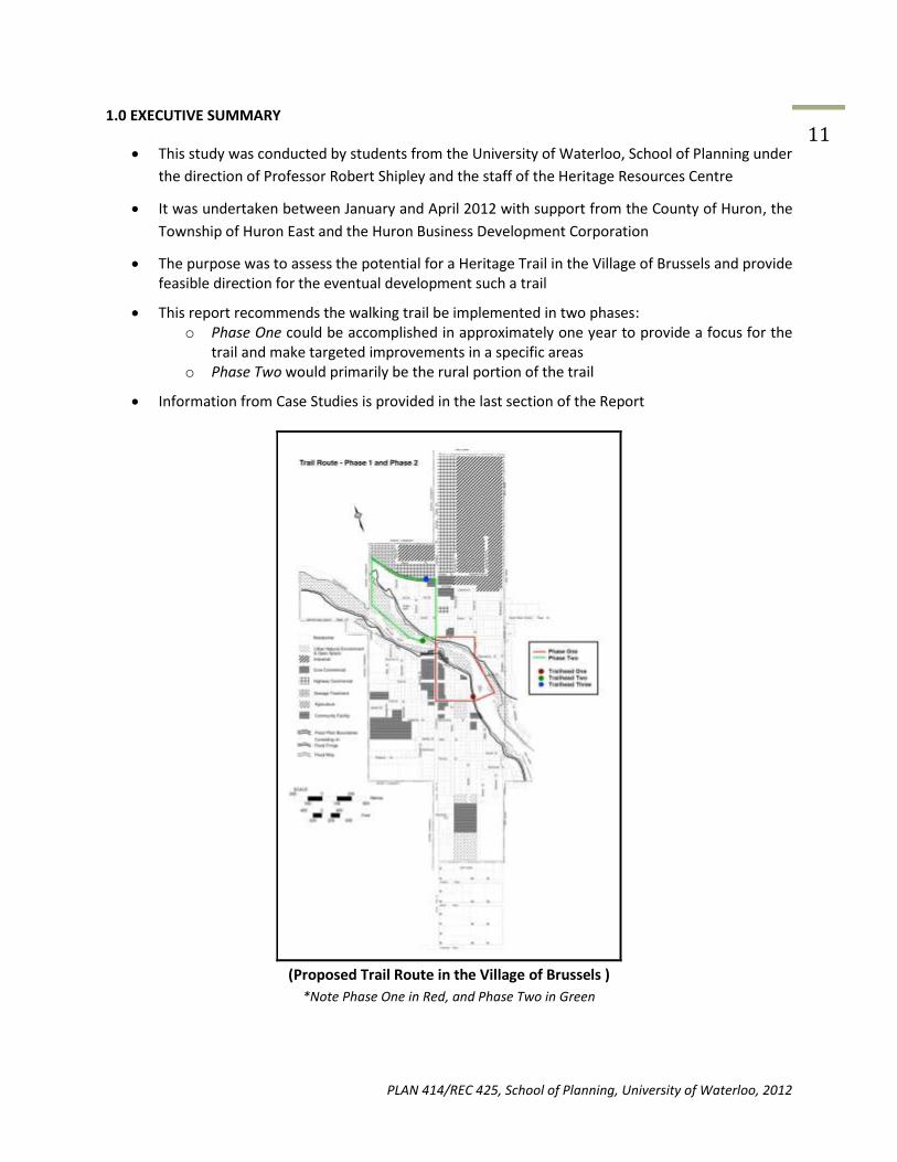
11 1.0 EXECUTIVE SUMMARY
This study was conducted by students from the University of Waterloo, School of Planning under
the direction of Professor Robert Shipley and the staff of the Heritage Resources Centre
It was undertaken between January and April 2012 with support from the County of Huron, the
Township of Huron East and the Huron Business Development Corporation
The purpose was to assess the potential for a Heritage Trail in the Village of Brussels and provide feasible direction for the eventual development such a trail
This report recommends the walking trail be implemented in two phases: o Phase One could be accomplished in approximately one year to provide a focus for the
trail and make targeted improvements in a specific areas o Phase Two would primarily be the rural portion of the trail
Information from Case Studies is provided in the last section of the Report
(Proposed Trail Route in the Village of Brussels )
*Note Phase One in Red, and Phase Two in Green

PLAN 414/REC 425, School of Planning, University of Waterloo, 2012
12

PLAN 414/REC 425, School of Planning, University of Waterloo, 2012
13 2.0 BACKGROUND/INTRODUCTION
2.1 Purpose
The purpose of this report is to outline recommendations in relation to the proposed construction of a
walking trail in the Village of Brussels, and provide a set of best practices through case studies (See
Section 12.0) as well as provide trail design, material, promotion, and policy recommendations.
2.2 Overview
This report is prepared in cooperation with the Heritage Resources Centre (HRC) and the University of
Waterloo Heritage Planning Workshop students following consultation and field work with the Village of
Brussels stakeholders, community members and project personnel.
Recommendations outlined in this document will focus on the implementation of a recreational-use trail
in the Village of Brussels, being a small rural community with a population of approximately 1,000,
located in the municipality of Huron East along the Maitland River. This study provides an assessment of
the projected costs and benefits with trail implementation, to be described as Phase One and Phase
Two.
3.0 STUDY AREA
The Village of Brussels is located within the Huron County, Ontario, part of the Municipality of Huron
East. The study area is primarily focused on neighbourhoods adjacent or in close proximity to the
Maitland River and the associated Mill Pond. It will also connect to the former Grand Trunk Railway
tracks.
The former Grand Trunk Railways tracks were located in the north side of Brussels, alongside the sewage
treatment plant and agricultural land. The full historic map of the Village of Brussels is an extracted map
of the former railway (See Map 1).
Logan’s Mill is located on the west side of the Mill Pond, at the end of Flora Street. Beside Logan’s Mill is
the walkway on top of Brussels Mill Dam; the dam leads to Brussels Conservation Area.
On the east side of the Mill Pond, across the Brussels Mill Dam, is the Brussels Conservation Area. The
Conservation Area consists of a washroom facility, picnic area, playground equipment, walking trails and
a Butterfly Garden (MVCA, 2012). The Butterfly Garden is located along one trail close to the Mill Pond.
The garden wraps around three concrete plaques and eight stone benches. The Brussels Conservation
Area eventually leads on to a residential street, Albert Street and Dunedin Drive. On Dunedin Drive are
three original 1880s buildings, the Melville Presbyterian Church, Dunedin Manor and Leckie-Hoy House
(Huron East, n.d.).

PLAN 414/REC 425, School of Planning, University of Waterloo, 2012
14
Map 1: former Grand Trunk Railway and Brussels Rail Station
(Extracted from Brussels Historic Map)
4.0 CONCEPTS/APPROACH
4.1 Methods
4.1.1 Public Consultation
On Monday February 13, 2012, a stakeholder meeting was held at the University of Waterloo, between
three stakeholders from Brussels and 20 students who were assigned Brussels for their group project. In
attendance were Sandra Weber (Huron County Senior Planner), David Blaney (Town Councilor and
Historian) and Janice Hawley (Economic Development Officer of the Municipality of Huron East)
On Saturday March 3, 2012, public consultation was held with David Blaney, Kathy Nichol and Sandra
Weber at the Village of Brussels in Cinnamon Jim’s. David Blaney accompanied the team through parts
of the residential area adjacent to the North side of the Maitland River and provided helpful
information, such as the ownership of the properties along the potential trail area, the flood season and
historical background of properties along the walk.
Sandra Weber provided a GIS map of the ownership of all the properties along the Maitland River and
Mill Pond, and up to the former railway tracks.
Kathy Nichol recommended that more of the downtown of Brussels, like the gazebo on Turnberry
Street, be incorporated into the proposed trail. The gazebo on Turnberry Street, in the middle of the
block, is located where a storefront had previously occupied but had burned down in a fire. The trail
would go south on Turnberry Street, then east on King Street, eventually leading the user to the Mill
Pond and Logan’s Mill. Another recommendation from Brussels residents was to walk further south on
Turnberry Street and then go east on Flora Street, passing through Victoria Park, before ending at
Logan’s Mill.

PLAN 414/REC 425, School of Planning, University of Waterloo, 2012
15
4.1.2 Field Work
On Saturday March 3, 2012, five students explored and walked through Brussels, Ontario. They took
pictures and made identified areas that would be aesthetically pleasing to people and areas that would
pose potential hazards. Some aesthetically pleasing areas were the Butterfly Garden in the Brussels
Conservation Area and the view along the Maitland River. Some potential hazards are the floodplain
areas along the Maitland River, where flooding typically occurs during the months of May and June, and
the former railway tracks, which is overgrown with vegetation.
In the early morning hours on Saturday March 24, 2012, three students drove to Brussels. Due to the
weather conditions on March 3, 2012, the majority of the team did not have a chance to walk the
former railway tracks, visit the gazebo on Turnberry Street or walk down King Street. The team was able
to take more pictures and notes about the study area.
4.1.3 Comparative Studies/Research:
Six case studies of other trails in Ontario were studied in depth and recommendations from each case
study were applied towards the proposed Brussels trail (See Section 12.0).
4.2 Limitations and Considerations
There are two limitations and considerations that need to be taken into account. There are the property
ownership and liability concerns as well as floodplain hazards along the Maitland River and Mill Pond.
The majority of the properties along the Maitland River and Mill Pond are privately owned (See Map 2).
Permission should be obtained from the owners of the properties, and follow the recommendations
outlined in Section 10.3 of this report.
The floodplain areas surrounding the Maitland River and Mill Pond flood during the months of May and
June. Even though the majority of the floodplains along the Maitland River are privately owned,
permanent structures were prohibited from being established, because of the flooding and the hazards
associated with flooding.

PLAN 414/REC 425, School of Planning, University of Waterloo, 2012
16
Map 2: Private and Public Ownership of Lands in the Village of Brussels
(Huron County Planning Map)

PLAN 414/REC 425, School of Planning, University of Waterloo, 2012
17 5.0 HISTORIC CONTEXT
5.1 Origins
The Village of Brussels was established in 1855, however the area was known by two other names,
Ainleyville, Brussels and Dingle. The original name of Brussels was Ainleyville, of William Ainley, who was
the first settler to lay out a town site on the Maitland River. The name Dingle came about when the local
post office was built and the postmaster subsequently named the post office. It is believed that the
postmaster named the post office after his home village, Dingle Peninsula in Ireland (Municipality of
Huron East, n.d.). Around that time period, the Grand Trunk Railway, also known as the Great Western
Railway, constructed the Brussels Railway Station. The workers of the Grand Trunk Railway, named the
station Brussels after their homeland of Belgium. As there were three names in the village, leading to a
lot of confusion. On December 24, 1872, the name was changed to Brussels when the village was
officially incorporated (Village of Brussels, 2003).
5.2 Downtown Brussels
The oldest part of Brussels was built in the 1860s. Brussels experienced several significant fires since the
1860s, with the last substantial fire occurred in 1980 when the Olympia Restaurant was destroyed
(Parks-Mintz, 2010). That was when Brussels decided to build all of their buildings out of brick as oppose
to wood. Fortunately, when Brussels rebuilt their business district, the buildings retained its original
architecture from the late 1800s and mid-to late Victorian streetscape (Parks-Mintz, 2010). When a
small fire burned down a building on the block (date unknown), a gazebo was built on the site (See
Figure 1).
Figure 1: View of front entrance of gazebo, facing East.
(Contemporary Photograph, Melinda Liu, 2012)

PLAN 414/REC 425, School of Planning, University of Waterloo, 2012
18
5.3 Logan’s Mill and Brussels Mill Dam
In 1859, William and James Vanstone built a flourmill, sawmill and gristmill at the site of the future
Logan’s Mill (MVCA, 2012). A wooden dam was also built onsite. Twice the mills were destroyed by fire,
the first was in October of 1871 and the second in 1911 (Municipality of East Huron, n.d.). Between 1914
and 1915, John Logan built Logan’s Mill, a cement gristmill. Mr. Logan also put a cement cap on the dam
(Municipality of East Huron, n.d.). The mill operated until 1967, where it was no longer profitable due to
the age of its equipment and small size (Municipality of East Huron, n.d.). The property was sold in 1972
and is now under the ownership of the Maitland Valley Conservation Authority. The Brussels Mill Dam is
adjacent to Logan’s Mill. Brussels Mill Dam was constructed across the Maitland River in 1986, where
the Mill Pond was dredged, a man-made island was created in the middle of the dam and erosion-
control structure was built along the river to help mitigate flooding (Municipality of East Huron, n.d.).
5.4 Brussels Rail Station
The Brussels Rail Station was built in 1873 in the North side of Brussels, officially opened on July 1st,
1873 (Municipality of East Huron, n.d.). The Grand Trunk Railway Brussels Rail Station was part of the
South Branch Wellington, Grey and Bruce railway branch, was the largest railway station in the world at
Confederation and connected Sarnia, Ontario to Portland, Maine (The Canadian Encyclopedia, 2012). By
1919, the Grand Trunk Railway faced financial ruin after they built a transcontinental line. Eventually the
federal government stepped in and placed all of Grand Trunk Railway under the management of the
Canadian National Railways in 1923 (The Canadian Encyclopedia, 2012).
In 1970, passenger service to Brussels stopped and in 1975 part of the station was dismantled and
relocated to another site in Brussels, where it serves as the Optimist Club House (Municipality of East
Huron, n.d.). The last train ran through Brussels in 1989, after which the rail line was abandoned.
5.5 Architecture
The Village of Brussels is home to a variety of architecture typical of the late 19th century; most notably
the Carnegie inspired Brussels Public Library, the Melville Presbyterian Church and residential estates.
Brussels had the honour of being one of 111 Ontario towns to have a Carnegie library, with a Carnegie
grant of $7,000 (Municipality of Huron East, 2012). Prior to the establishment of the Brussels Public
Library, there was the Mechanics’ Institute Library and Reading Room, established in 1874, however it
was located above a store on Holmes Block and had experienced a fire at one point (North Huron, 2010).
There was controversy over the location of the library; eventually a lot at the corner of Turnberry Street
and Mill Street was purchased. On January 14, 1910, Brussels Public Library opened to the public (See
Figure 2) (North Huron, 2010). Common elements of Carnegie libraries consisted of “an exposed
basement, a centrally located main entrance, classically columned porticos and a symmetrical
arrangement of windows” (Municipality of East Huron, 2012). During World War II, the basement of the
library facilitated local Red Cross-related activities.

PLAN 414/REC 425, School of Planning, University of Waterloo, 2012
19
Figure 2: View of Front Entrance of Brussels Public Library, facing West.
(Contemporary Photograph, Melinda Liu, 2012).
In 1857, the original Melville Presbyterian Church was established (Village of Brussels, 2003). In 1914,
the Church was torn down and a new Church was built on Dunedin Drive, across the street from
Dunedin Manor. The Presbyterian Church was one of only two churches built with this design by the
same architect who designed the other church in Stratford (See Figure 3).
Figure 3: View of Front Entrance of Melville Presbyterian Church, facing North.
(Contemporary Photograph, Melinda Liu, 2012).

PLAN 414/REC 425, School of Planning, University of Waterloo, 2012
20
A well-known and exquisite residential estate, Dunedin Manor, is located on Dunedin Drive (See Figure
4). Dunedin Manor was built in 1887 for Dr. W.J.R. Holmes and modeled after Scotland’s Dunedin Castle
(Huron East, n.d.). Dunedin Manor is well known as one of the five great Victorian estates located in
south-western Ontario, with stained glass windows, carved tiger and cherry woodwork, high ceilings and
original plaster moldings (Huron East, n.d.). Dunedin Manor looks over the Maitland River.
Figure 4: View of Dunedin Manor, facing South.
(Contemporary Photograph, Melinda, Liu, 2012).

PLAN 414/REC 425, School of Planning, University of Waterloo, 2012
21 6.0 TRAILS
Walkers, runners, cyclists, and people with mobility aids typically use Multi-Use Trails. In order for these
trails to be accessible to everyone, it requires trails that have a harder surface, like asphalt, and
increased sight visibility along the trail in order for recreation users to have a clear visual of the trail and
other users on the trail.
6.1 Economic and Social Benefits
Trails are considered a desirable asset to the community. Trails are a sustainable form of tourism and
recreation, becoming the preferred form of recreation and exercise. Cities, towns and regions are seeing
the economic and social benefits of having a well-designed and well planned trail system. Some trail
systems have been a catalyst for increasing tourists, improving the quality of life of local residents and
increasing in the potential to attract new development into the community (Stantec Consulting Ltd.,
2000). Trails provide economic benefits to the local economy both during construction and operation.
The community is united throughout the construction, operation, maintenance and promotion phase of
the trail project. Communities are able to interact with different neighbourhoods and people of
different backgrounds. Trail projects can help promote partnerships among local businesses, individuals
and government. The social benefits include accessibility, sense of community, improved health,
linkages of heritage resources and preservation of natural resources (Stantec Consulting Ltd., 2000).
6.2 Accessibility and Health
Trails are accessible to all levels of physical ability, people of all income levels and are readily available
for recreational activities. Trails help promote increase physical activities, such as walking and biking,
which help decrease the risk of illness. Active participation would reduce the cost of medical care,
decrease workplace absenteeism, provide a low cost recreational activity and reduce the cost of
institutional care (Stantec Consulting Ltd., 2000).
6.3 Resources
Trails provide more opportunities for recreational users to appreciate their surroundings, such as
heritage and cultural sites. It also encourages them to seek out educational activities. Trails through
former railway lines may be a valuable source of vegetation, where stretches of indigenous plant
materials may have been preserved (Stantec Consulting Ltd., 2000). Trails along the floodplains and
forest areas would serve to educate recreation users, while preserving the majority of the land from
development and disturbance.
6.4 Limitations
There are two major limitations of trails, funding and maintenance. Funding will dictate the type of
material used to construct the trails and the length of the trail. Without adequate funding, the trail may
not be accessible to everyone, especially those in wheelchairs as they require hard trail surfaces.
Maintenance is another limitation, where depending on the material of the trail, there may need to be
additional maintenance performed throughout the season to ensure that the trail is well maintained and
free of debris or hazards.

PLAN 414/REC 425, School of Planning, University of Waterloo, 2012
22

PLAN 414/REC 425, School of Planning, University of Waterloo, 2012
23 7.0 ENVIRONMENTAL ASSESSMENT
This section will review the environmental implications the trail may pose on the natural environment,
provide information regarding floodplain and railway restoration as well as maintenance
recommendations.
7.1 Natural Environment
The Brussels trail will be laid through a variety of natural features. The Maitland River runs through the
center of town and represents a major attraction to local citizens and visitors. Every spring, the Maitland
River floods much of the lower portion of the village then retracts following the spring thaw. The
floodplain covers a great extent of the location of the proposed trail and will limit its use for much of the
spring season. Much of the vegetation along the river in Phase 1 consists of manicured grass. A wet-land
area is located near the dam consisting mainly of tall grass-type vegetation.
Phase two displays a different variety of vegetation. The area that extends from the north-west portion
of Dunedin street backs onto wet grassland, also flooded every spring. This area has a variety of grasses
and trees, including black willows. This area extends out of town and changes primarily into an
agricultural landscape.
A Dam is located on the southern portion of the river separating the Mill pond and the lower Maitland
River. The dam was originally built in the early 1900s to facilitate and control water power to the Logan
Mill. Not too long after it was built, a fire destroyed the original mill and it was then reconstructed in
1924. Dams have the ability to alter river ecosystems and hydrology both upstream and downstream.
According to the Food and Agriculture Organization (FAO 2002), this affects water quality, quantity, and
habitat for wildlife and fish. Having been a part of the river system for an extended period of time, the
river does not flow as it had before the dam was built.
The Brussels Conservation Area can be found across the dam from the Logan Mill and consists of a
playground, picnic tables, benches and a butterfly garden. In the center of town, a second park area can
be found consisting of a gazebo and variety of flower gardens. This area was created amongst buildings
in the main core after a building was destroyed in a fire.
The northern portion of town displays an old railway line belonging to the Grand Trunk Railway. Grasses
have over-grown the old railway line and are lined with trees.
7.2 Impact on surrounding area
Overall, the impacts of this trail should be fairly minimal, as the majority of the trail is already laid out
through already-existing sidewalks and park trails. The most impact on the land will be in Phase Two,
where the trail will cut through the wet grassland section of the river side, where the material being
used will be less permeable than that of the natural environment. It is recommended that when
choosing a material it should be durable as well as permeable. Due to the loss of some vegetation,
floodwaters may increase with a less permeable surface. This has the potential to cause the river to
move at a slightly faster speed due to less area for water retention (less land to hold water).
Potential impacts affecting the natural area due to the implementation of a trail include:
People walking off path and damaging vegetation
PLAN 414/REC 425, School of Planning, University of Waterloo, 2012
24 People walking off path and creating new trails for short-cuts Increase in car visitation requiring the need for an increase of parking spaces
Increase in car visitation increasing the amount of car fumes Increase in pedestrians and visitation can lead to an increase in litter
7.3 Possibilities for Restoration
Opportunities for ecological preservation and restoration can be found in both phases of the trail
creation.
7.3.1 Floodplain
Investment in native grasses and flowers could be incorporated along the pathway. These are both
attractive and could be classified as a pollination stop over. These plants will help the floodplain retain
and clean the water. Native plants, especially in the wet grassland area are recommended as they
provide great ecological services to water flow. Vegetation in the floodplain helps to slow water speeds
and filters nutrients from nearby agricultural fields before being integrated into the water system. These
also have the ability to stabilize soil and to reduce erosion-prone areas.
This report also recommends the preservation of the black willow/wet grassland area. Black willows
are commonly found in wet areas along riverbanks and work well to provide foliage for animals to
eat and make habitats. Foliage also provides soil stability. While this tree species has many benefits,
black willows grow tall quickly and die off at a young age. After these trees fall, they may be left as a
source of nutrients for the land. However, an over-abundance of fallen trees may prove to be a
safety hazard or eye-sore. It may prove to be a better option to find a species of tree that is slower
growing, better suited for the area.
7.3.2 Railway
The introduction of native plants and trees will be beneficial to the railway corridor. This phase of the
trail would see the industrial area of the city as well as the waste water treatment plant. In the future, it
is recommended to plant new native plants along this route, whether it be trees or a native meadow
plants. It is recommended that trees be planted to reduce the visibility of these places and increase the
tree stand in Brussels. With the addition of native species, Brussels must also ensure that there is a
counter-plan to remove invasive species that are in the area. We can see that there are plenty of
opportunities for restoration and preservation within the area. This report recommends that in the
future, an ecological restoration plan be created.
7.4 Trail Maintenance
Trail maintenance is one of the most important aspects of creating a trail. The majority of maintenance
will need to occur during winter and spring. During winter (pending the trail will be allocated for winter
use) a snowplow will be needed to clear the trail for users. This will need to be done after every snowfall
and ice/sand may need to be applied to ensure ice does not promote a safety risk, such as slips and falls.
PLAN 414/REC 425, School of Planning, University of Waterloo, 2012
25 The trail will also need to be maintained in the late spring. After the yearly flooding has retreated, debris
will need to be removed from the trail. Due to the freezing and thawing of the ground in winter, there
may be effects on the trail ground-material. For example, asphalt tends to sink, split, become uneven
and develop potholes due to the thawing and freezing events. These will need to be tended to ensure
the trail has a smooth surface not allowing for any hazards to trail-users.
During the spring-fall months, storm events are likely to occur. These can cause high winds and lightning
which may have the ability to collapse trees. Maintenance crews need to ensure there are no large limbs
blocking the pathway. Wood from these storms has the potential to be reused into woodchips for local
flower gardens.
8.0 OPPORTUNITIES AND PROMOTION
The proposed walking trail provides the opportunity to attract more people to the village of Brussels,
and to retain visitors for a longer period of time once they have begun their visit, hopefully leading to
opportunities for more outside-money to be spent in Brussels. Promoting the trail is important to this
project. If nobody knows about the trail, then it cannot effectively play a role in reinvigorating the
community. Print promotion opportunities in the surrounding areas, as far as Kitchener-Waterloo and
London, are numerous and reach a large and highly relevant audience. Online promotion opportunities
are also extensive. Leveraging social media and opportunities to distribute information regarding the
trail and the Village of Brussels without incurring advertising costs are readily available. Hosting
information on the websites of local municipalities and organizations will also help people find the
information they seek, hopefully culminating in a visit to the Village. A focus on low-cost promotion and
distributing information strategically is the key focus of this section.
8.1 Trail Opportunities
The proposed walking trail provides an opportunity to add an attraction to the Village citizens interested
in scenic walks or fitness, and to provide additional visitors with yet another activity that could grab
their attention. This is the goal for which Brussels community leaders have indicated they have for the
trail: an impressive and attractive piece of infrastructure. It is important to get the message out about
this new piece of infrastructure if Brussels is to expect an increase in visitors. The trail provides a new
and simple way to experience all of the sights the Village has to offer, from the riverfront to historic
homes and buildings. It is importance to generate visitors to Brussels, as well as keep them in the Village
once they have arrived. This makes the process of promoting the trail and the Village important. If the
stakeholders are to contribute money to the project, there must be a plan in place to ensure the trails
success and meet its expectations. There are many means through which Brussels could promote itself
and its new trail, but this report outlines print and online promotion opportunities, in the context of the
Village and in its current situation, the most effective and cost-efficient methods currently available.
8.1.1 Print Promotion Opportunities
The local newspaper, The Brussels Citizen, should continue running articles regarding the progress and
decisions made regarding the trails’ construction. This should include its opening, as they did on March
8, 2012, when an article entitled “Brussels University Project Promising says Hawley” was the front page

PLAN 414/REC 425, School of Planning, University of Waterloo, 2012
26 story. This will essentially be free-of-cost publicity, which achieves the goal of informing the local
community without having to expend advertising dollars. In terms of the surrounding community,
Brussels is relatively close to two large cities: Kitchener/Waterloo/Cambridge, as well as London. The
Waterloo Record, which is the major newspaper in Waterloo Region, has an extensive focus on local
news. The London Free Press is an attractive option in another large, nearby city. Trying to reach readers
in these nearby markets is a goal for the promotion process because of the circulation of these
newspapers; many people interested in rural communities such as Brussels will be reached with the
message of the new walking trail. Also, the many print publication promotion opportunities which exist
in and around Brussels should be explored, including regional and local newspapers in communities such
as Goderich.
8.1.2 Print Promotion Recommendations
As community leaders in Brussels want people outside of the village to hear about the trail, print
publications throughout Huron County and surrounding areas should be included in the scope of the
promotion process. Spending promotion dollars on print advertising would probably be an unnecessary
expense considering the effectiveness of word-of-mouth publicity in small communities such as Brussels.
Also, making additional resources available such as a physical brochure in businesses and community
buildings such as the library provides citizens with a readily available source of information that includes
detailed information regarding the trail. It also provides people with direct communication from those
community leaders who are planning and maintaining the trail rather than relying on word-of-mouth
communication or media coverage.
8.1.3 Online Promotion Opportunities
Online promotion opportunities for the trail include Regional websites, which could provide information
regarding the trail include:
1. www.ontarioswestcoast.ca, which has a hiking guide for Huron County in a .pdf file viewable in web
browsers. This website is easily found by people interested in trails in Huron County, who will possibly
make up a sizable portion of the trails’ users.
2. www.huroncounty.ca, another site which has a “newsroom” page of news regarding the county.
Posting an article regarding the construction of the trail and its opening date could also lead some
people towards Brussels at the time that the trail officially opens to the public.
3. www.villageofbrussels.ca, The Village of Brussels own website, is an obvious choice for hosting
information about the trail, as people who are searching for information specifically about the village
will quite possibly be interested in visiting the village and taking a walk.
4. www.huroneast.com, The Municipality of Huron East’s website has several pages that could host
information about the trail, such as “sports and recreation.” The community calendar on the website
could also be made to include the opening date of the trail, so that interested citizens in the municipality
will have a better chance of becoming aware that the trail is being constructed.

PLAN 414/REC 425, School of Planning, University of Waterloo, 2012
27 5. www.mvca.on.ca, Also, considering that the trail will likely run along the river at some of its points,
the website of the Maitland Valley Conservation Authority could be a useful website on which to host
information, considering their “news & updates” section on the homepage, and the information
regarding specific conservation areas, such as the Falls Reserve Conservation Area.
6. www.facebook.com/www.google.com, It is also important to note that with the rise in popularity of
social networking, many people may search websites such as facebook or Google Plus for information
regarding a town or an piece of infrastructure the way that they would search for similar things on a
search engine such as Google. Social network “pages” (dedicated web pages on larger social networking
sites which display information about a certain person, place, or thing) are of interest to the public
because they allow the people in charge of a web page to communicate with interested people directly,
and to get messages out to interested parties in a way that is comfortable to them. By having a facebook
“wall” on which anyone can post an inquiry or a suggestion, communication with interested parties for
the betterment of the trail and the village of Brussels will more easily take place, and there will be yet
another source of information for interested people to find online.
8.1.4 Online Promotion Recommendations
Considering once again that the trail is not a consumer product, and its success is not based on usage or
any kind of direct monetary return (use of the trail is, of course, free of charge), online promotion for
the trail does not need to have a selling-based approach. The goals of promotion should be to inform
citizens regarding the Brussels trail specifically. Most users of the trail will likely be people who are
stopping by on their way through town, or people who came to Brussels specifically. Another factor of
this low-budget approach is that the websites mentioned above will hopefully, in most cases, be willing
to host information free of charge, considering that these organizations are affiliated in some way to
Huron County and the local government in Brussels. Getting into contact with those who maintain these
websites and make decisions regarding them should be quite simple considering the local connections.
There should be two main focuses for the online promotion efforts of the trail. The first is to provide
news updates and post news stories on relevant local websites which offer news for the local area
corresponding to important dates regarding the trails’ construction, opening, and perhaps its route and
composition. The second focus area should be on informing: creating a wide net of information
resources regarding the trail, and distributing this information among relevant websites that will be
easily found when performing a web search increases their chances of learning about the Brussels trail
and visiting the Village. Using social networking sites as part of this informing process is also a free and
easy-to-manage possibility, with the additional benefits of easy dialogue between those providing and
maintaining the trail (the village of Brussels) and those who are interested in using the trail. The
suggestions that users and interested parties can bring to those in charge of the trail could be very
valuable, and these pages are also an additional way of distributing information about the trail. An
official “Village of Brussels” facebook and Google Plus page, and perhaps a presence on other social
networks could help to build community and communication within the Brussels area and among those
interested in the walking trail. Also, this type of direct communication with the citizens of Brussels could
help to identify those citizens who are passionate about the project or with civic improvements in
general, and work to create and foster more leadership for the future in the village.

28
Illustrations from this 1920s book on milling can
provide the subject matter for interpretive signage. A turbine similar to this one now sits in from of Logan’s Mill. These pictures explain how
that artifact worked when the mill operated. (See Interpretive Signage pages 33 and 35)

29 9.0 TRAIL DESIGN
The trail design takes into consideration the historic and cultural assets of Brussels, incorporating the
downtown, mill pond, Maitland River, and abandoned railway corridor. These community assets are
worthy of inclusion along the trail and recognition through interpretive signage. This section will detail
the proposed trail route, followed by suggestions for trail elements including materials, signage and
decorative features.
Map 3: Phase One and Phase Two of the proposed Brussels trail (Adapted from the Municipality of Huron East Official Plan Land Use map, 2009)
9.1 Trail Route
The proposed trail route forms a figure-eight through Brussels. It has been broken down into a two
phase project; Phase One being the most simple to create while Phase Two will require more funding,
resources and effort (See Map 3). Phase one could be implemented immediately, while phase two
should be implemented at least one year later. Phase one is suggested as the first length of trail to
install, because it follows existing surfaces (sidewalks, asphalt pathways) which will reduce initial costs.
Phase one focuses on improving the core, by implemented public art and historical information around
the mill (see sections 9.2.2. Signage; 9.2.3 Elements for Enhanced Experience). Phase one should be

PLAN 414/REC 425, School of Planning, University of Waterloo, 2012
30 used to spark community interest in the trail, and then subsequently branch out further from the core
with Phase Two. Phase Two is larger, incorporates more natural landscape, and will costs more in
surface material construction and agreements with private property owners.
9.1.1 Phase One
Phase One focuses on the downtown strip, mill pond, and Dunedin Drive. The trail loop begins at the
mill, where a large grassy area provides space for a trailhead (see section 5.2.3 Elements For Enhanced
Experience). The trail follows existing pathways, crossing the dam then continuing north on the existing
asphalt path through the Brussels Conservation area. Exiting the Conservation Area, the trail continues
north on Albert Street using a short section of roadway and sidewalk. At Albert Street and Dunedin
Drive the trail heads west, traveling past the historic homes of Dunedin Drive. At Dunedin Drive and
Turnberry Street the trail turns south, using the sidewalk to pass through the downtown core. As
Turnberry intersects with Flora Street the trail heads east once more, passing the Brussels community
park sports field to connect with the trailhead at the mill.
Phase One uses existing sidewalks and paved pathways, minimizing the cost of trail tread material. This
section of the loop requires well-defined signage to create ‘sense of place’ (see section 5.2.2 Signage).
9.1.2 Phase Two
Phase Two resembles a more nature-based trail than Phase One, which utilizes historic elements. The
Phase Two loop begins near the intersection of Dunedin Drive and Turnberry Street, slightly down
Dunedin Drive where the grade from the street to the river bank is less steep. A deteriorating (hopefully
restored) asphalt pad and ramp mark a good location to begin the trail. The trail then heads north-west
along the river bank of the Maitland River until it intersects with the abandoned rail corridor. The trail
then follows the abandoned rail corridor east until Turnberry Street where it then heads south, along
the sidewalk, to the beginning of the loop at Dunedin Street.
Phase Two poses significantly more construction and preparation than Phase One. Following the bank
of the Maitland River poses the risk of spring flooding –thus requiring a solid tread material such as
asphalt or concrete which will not wash away (See Details in Section 7.2). The river bank also crosses
upon private property so arrangements with landowners will be necessary. The abandoned rail corridor
will require clearing and the laying of gravel surface material.
9.2 Trail Elements
Trail elements will build up the trail to create a ‘sense of place’ with the recognition of the trail as an
important community asset. Trail elements include the base material of which the trail is built, signage
directing the trails’ use, and features along its length including benches, gardens and public art.
9.2.1 Materials
The trail material forms the surface of the trail. When choosing a surface material consider:
accessibility, cost to purchase and install, cost of maintenance, life expectancy, user acceptance, and
satisfaction (RTC, 2007). Following are materials to consider for Phase Two construction (See Tables 1-3).

PLAN 414/REC 425, School of Planning, University of Waterloo, 2012
31 Table 1: Trail Materials and Cost Estimates, Stone Dust/Gravel Stone Dust/Gravel
Advantages
Cheap installation cost
Soft on joints (running)
Blends with the natural environment (as compared with asphalt and concrete)
If crushed and compacted properly, accessible for walkers, bikers, and wheelchair users
(RTC, 2007; Saitta, 2011)
Disadvantages
High and ongoing maintenance costs
Difficult to maintain a consistent surface quality
Rainfall causes a dirty surface, sometimes remaining for days after
Inaccessible to inline skaters; difficult for bikers on steep slopes and in loose gravel
(RTC, 2007; Saitta, 2011)
Cost Estimate
Construction: $27.50m. (City of Brantford, 2000. 1999 cost of $25m +10% inflation)
Annual Maintenance: $3.28m (in non-washout areas);
$10.50m (in washout/flood-prone areas). (Saitta, 2011. 2009 Cost estimates)
Application
Phase two, the abandoned rail corridor.
Table 2: Trail Materials and Cost Estimates, Asphalt Asphalt
Advantages
Accessible for walkers, bikers, inline skaters, wheelchair users
Hard surface, will not wash away along flood plain
Initially cheaper than concrete trails
(RTC, 2007; Saitta, 2011)
Disadvantages
Requires crack repair maintenance, sealing
Develops cracking caused by tree roots
Flexible surface which lasts longer with regular use to remain pliable
Life expectancy: 7-15 years
(RTC, 2007; Saitta, 2011)
Cost Estimate
Construction: $49.50m (City of Brantford, 2000. 1999 cost of $45m +10% inflation)
Annual Maintenance: $5.39m (Saitta, 2011. 2009 Cost estimate)
Application
Phase two, following the river bank of the Maitland River

PLAN 414/REC 425, School of Planning, University of Waterloo, 2012
32 Table 3: Trail Materials and Cost Estimates, Concrete
Concrete
Advantages
Accessible to walkers, bikers, inline skaters, and wheelchair users
Best consistency of surface. Resists washing or breaking apart
Longest lasting material. Life expectancy of 25+ years
Suitable for urban areas with severe climate swings and areas prone to flooding
Retains a cleaner surface during and after rain
(RTC, 2007; Saitta, 2011)
Disadvantages
Initially expensive
Hard on joints (running)
Considered less natural-looking
(RTC, 2007; Saitta, 2011)
Cost Estimate
Construction: $55m² (Sidewalk cost: British Columbia MTI (2011)
Annual Maintenance: $1.85m (Saitta, 2011. 2009 Cost Estimate)
Application
Phase two, following the river bank of the Maitland River –cost permitting
* Note that woodchips and packed earth, although common trail materials, are not considered.
These natural materials pose accessibility challenges due to an uneven surface, have a short life span due
to decomposition, and require constant maintenance (RTC, 2007).
9.2.2 Signage
Trail signage keeps users on-route, and has the ability to enhance the user experience when historic and
natural elements are outlined and interpreted. See the Cambridge to Paris Rail Trail case study for an
example of signage use, particularly interpretive signs (See Section 12.3).
All trail signage should embody the same design and construction elements, so they are immediately
recognizable by trail users (City of Brantford, 2000). Consistent use of a trail logo unifies all signs, while
decorative landscaping around sign posts improves visibility (City of Brantford, 2000). Trail signage is
categorized into: information boards, directional markers, and interpretive signs.
Information Boards are best placed at trailheads to provide an overview of the trail system (See Section
9.2.3 Elements for enhanced experience). Information boards should be large and visible from a
distance, so as to identify the trail to users and passing motorists (City of Brantford, 2000). Information
boards include the following information (City of Cambridge, 2010):
PLAN 414/REC 425, School of Planning, University of Waterloo, 2012
33 Orientation to the trail system
o Route map: Trail system and sign’s location relative to the network.
o Location of special attractions
What trail users can expect
o Length of each trail phase
o Surface types
o Maximum trail grade, difficulty rating
Regulations
o Identify permitted uses
o Hours of permitted use. Seasonal closure (e.g. river flooding)
Donor recognition (optional)
Directional markers are used to keep trail users on-route. They are small and simple in design, and used
at every intersection and connection point to cue trail users’ direction (City of Brantford, 2000). The trail
logo and a directional arrow must be included. Directional markers are very important in Phase One,
where the trail makes multiple direction changes. At each directional change, consider implementing a
directional sign. In spots requiring traffic warning (e.g. along Albert Street in phase one), downsized
standard traffic signs (with the trail logo attached) are suggested (City of Brantford, 2000). Directional
markers must be consistent and predictable, either on posts (best visibility) or on the ground. On-
ground markers can be painted or sandblasted into a sidewalk (City of Cambridge, 2010).
Interpretive signage develops awareness and appreciation for the trail’s incorporated natural and
historic features (Ashbaugh, 1971). In Brussels, the mill, abandoned rail corridor, and Maitland River are
all deserving of interpretive recognition. Each of these features can be correlated with the Village’s
history and development, answering how the landscape of Brussels acquired its current form. These
three elements are correlated with the trail’s suggested trailhead locations. Therefore interpretive
signage can be incorporated alongside information boards at these locations. Phase one includes historic
and cultural features that would also benefit from interpretive signage, for example signage detailing
the fire and subsequent gazebo between 439-449 Turnberry Street (Figure 5 and page 28).
Interpretive signage must balance between too much information which can overwhelm visitors, and
too little information which does not stimulate inquiry (Ashbaugh, 1971). Few people will take the time
to read long statements while walking a trail. The Cambridge to Paris Rail Trail case study (See Section
12.3) presents an example of interpretive signage which is quick to read and visually stimulating.
Information is compiled into bright collages with pictures and very short paragraphs (See Figure 5). One
panel details the former rail-line’s history, while another details the Grand River’s environmental
importance and conservation; similar historic and natural element which can be interpreted in Brussels.

PLAN 414/REC 425, School of Planning, University of Waterloo, 2012
34
Figure 5: View of interpretive signage, Canadian General Towers Trailhead, Hwy #24, Cambridge.
*Note: Railway and river information is presented in quick-to-read paragraphs with supporting images (Contemporary Photo, Margaret Ostermann ©, 2012)
9.2.3 Elements for enhanced experience
Trailheads serve as access points to the trail. Located at the trailhead, and throughout the trail,
elements for an enhanced trail experience include: benches, gardens, and public art. Trailheads are best
located where the system is highly visible to passing motorists, near community centers, or parks (City
of Brantford, 2000). In Brussels, 3 trailheads are suggested. In Phase One, the grassy area surrounding
the mill is suggested as a trailhead. In Phase Two, a trailhead is suggested near the asphalt ramp and
pad descending from Dunedin Drive to the Maitland River bank. Another trailhead is suggested along
Turnberry Street at the entrance to the abandoned rail-line section of the trail (see location of trailheads
on Map 3 in Blue). Trailheads often include (City of Brantford, 2000):
Parking facilities
o Difficult to incorporate at these locations in Brussels
Trash Receptacles
o Cost estimate $165 each (1999 cost of $150 +10% inflation)
Signage
o Information Boards and Interpretive signage (see section 5.2.2. Signage)
Washrooms and Drinking fountains
o Difficult and costly to incorporate in Brussels. Signage with nearby facilities is an option
Benches, Picnic Areas, Informal activity space
o Bench cost estimate $385 each (1999 cost of $350 +10% inflation)
Gardens and public art (see below)
Beyond the trailhead, benches and rest areas should be spread at regular intervals throughout the
system. The conservation area and gazebo on Turnberry Street (see Figure 6) of Phase One already
provide good rest stop locations. Additional benches could be added outside of the mill at the trailhead.
Phase Two suffers from flooding along the Maitland River, making benches more difficult to incorporate.
However rest areas need not be benches, instead, large rectangular-cut boulders –which will not wash
PLAN 414/REC 425, School of Planning, University of Waterloo, 2012
35 away- can be formed into seating areas (City of Brantford, 2000). The exact location and interval of
seating should be assessed on a site-specific basis, combined with scenic views, points of interest, and
shade (City of Brantford, 2000).
The popularity of community gardens is increasing. Brussels already benefits from the Butterfly Garden
in the conservation area, and community gardens maintained by the Girl Guides group. If these, or
other groups, are willing to take on the responsibility, more community gardens are suggested along the
trail. Phase Two offers garden opportunities at the rail-line trailhead, and perhaps at the Dunedin Drive
trailhead above the floodline. Gardens are especially effective at drawing attention to signage and
public art. Sustaining a garden contains many challenges: long-term maintenance, volunteer
management, and sometimes difficult growing environments (RTC, 2007). The Sheridan Nursery
website provides plant suggestions for low maintenance and native gardens at:
http://www.sheridannurseries.com/products_and_services/product_selection/sheridan_garden_classics
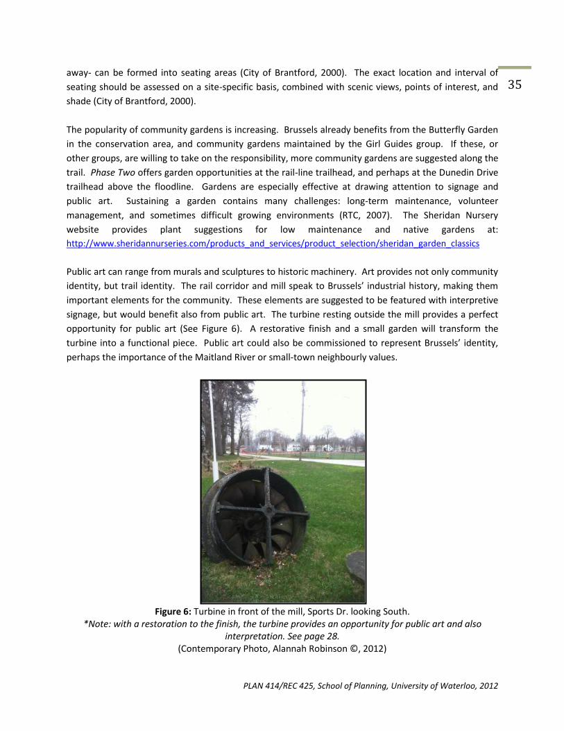
Public art can range from murals and sculptures to historic machinery. Art provides not only community
identity, but trail identity. The rail corridor and mill speak to Brussels’ industrial history, making them
important elements for the community. These elements are suggested to be featured with interpretive
signage, but would benefit also from public art. The turbine resting outside the mill provides a perfect
opportunity for public art (See Figure 6). A restorative finish and a small garden will transform the
turbine into a functional piece. Public art could also be commissioned to represent Brussels’ identity,
perhaps the importance of the Maitland River or small-town neighbourly values.
Figure 6: Turbine in front of the mill, Sports Dr. looking South.
*Note: with a restoration to the finish, the turbine provides an opportunity for public art and also interpretation. See page 28.
(Contemporary Photo, Alannah Robinson ©, 2012)

PLAN 414/REC 425, School of Planning, University of Waterloo, 2012
36
9.3 Challenge Level and accessibility
The proposed Brussels trail is of easy to moderate difficulty. The land is relatively flat, save a short uphill
walk on Albert Street and a significant grade on a short section of the pathway over the dam, both of
phase one. Neither phase of the trail is very long while frequent rest stops will alleviate fatigue.
The City of Cambridge Trails Master Plan (2000), states that the Accessibility Advisory Committee
discourages woodchip and packed earth trails as they pose accessibility challenges to wheelchair and
mobility devices. However, the committee approves that stone dust and asphalt trails are accessible, so
long as they are maintained adequately to provide an even surface. Trail information boards should
include trail conditions –length, maximum grade and its location, and surface types- so that trail users
know what to expect before departing (See Section 9.2.2).
The width of multi-use trails is recommended to be 3 metres (City of Cambridge, 2000). Construction
width is applicable to phase two where tread material will be laid. A 3 metre width allows for users to
safely pass each other.
9.4 Views and Incorporated Features
The following section provides a brief overview of incorporated elements and scenes along the trail
routes. Figures 7-10 are located in Phase One. Figures 11-13 are located in Phase Two.
9.4.1 Phase One
Figure 7: The Mill, Sports Dr. looking South
*Note: The large grassy area surrounding the mill provides space for a trailhead (Contemporary Photo, Vanessa Hicks ©, 2012)

PLAN 414/REC 425, School of Planning, University of Waterloo, 2012
37
Figure 8: Crossing the dam, near Flora St. and Sports Dr. looking East
(Contemporary Photo, Alannah Robinson ©, 2012)
Figure 9: Footbridge in the Brussels Conservation Area, looking North-East
(Contemporary Photo, Alannah Robinson ©, 2012)

PLAN 414/REC 425, School of Planning, University of Waterloo, 2012
38
Figure 10: Gazebo and garden between 439 and 449 Turnberry St.
(Contemporary Photo, Alannah Robinson ©, 2012)
9.4.2 Phase Two
Figure 11: Maitland River and Dunedin Dr. looking West from Turnberry St.
*Note: Asphalt pad and ramp in distance. Location for trailhead 2. (Contemporary Photo, Alannah Robinson ©, 2012)

PLAN 414/REC 425, School of Planning, University of Waterloo, 2012
39
Figure 12: Abandoned rail corridor, looking West
(Contemporary Photo, Vanessa Hicks ©, 2012)
Figure 13: View from abandoned rail corridor, looking South
(Contemporary Photo, Alannah Robinson ©, 2012)

PLAN 414/REC 425, School of Planning, University of Waterloo, 2012
40
Some historic pictures of Logan’s Mill provided by local residents.

PLAN 414/REC 425, School of Planning, University of Waterloo, 2012
41
10.0 POLICY/LEGISLATION
Before moving forward on any project concerning a walking trail within in the town of Brussels, the
Huron County Official Plan must be consulted and critically analyzed in order to comply with as well as
implement policy. Luckily for the proponents of the walking trail, the Huron County Official Plan
advocates for projects such as walking trails for a variety of reasons. However, developers must be
careful to conform to the rest of the plan as well.
10.1 Compliance with the Huron County Official Plan
Section 3.2: Community Direction
Section 3.2 of the Huron County Official Plan concerns the community’s direction. Within this section, it
clearly states that the community is a proponent “For recreation, culture, and heritage the community
wishes to provide opportunities for all age groups and abilities. Recreation includes culture, education,
tourism, athletics, and leisure activities. Residents are encouraged to be actively involved in organizing
recreational and cultural activities in their community” (Huron County, 2012). A walking trail, perhaps, is
the best project to conform to this direction as it satisfies many of the outlined characteristics.
Individuals of all ages are able to enjoy a walking trail while it also has the potential to attract a
moderate amount of tourism to the town. Regarding culture and education, the trail would take users
past areas of cultural significance to the town of Brussels (i.e. Logan’s Mill), while school groups could
use it for educational purposes along the water or in the natural sections of the trail.
Section 6: Environment
Regarding precautions to be taken during the implementation of the walking trail, Section 6, concerning
Environment of the Huron County Official Plan appears to be the area of focus. Section 6.1 (Community
Values) states “the community values a healthy environment including the quality of the water and air”
(Huron County, 2012). As the current proposal calls for the trail to run parallel with the Maitland River,
this section of the Official Plan is important to keep in perspective as to not affect the water integrity.
Erosion created by constant use of the path will be taken into consideration along the banks while a
natural buffer may also be explored to combat issues of trash.
Section 6.3: Community Policies and Actions
Section 6.3 of the Official Plan points out that “the protection of natural areas will occur through the
decision of property owners, the community, and local plans” (Huron County, 2012). This implies that the
responsibility of natural preservation is not the responsibility of an individual, but rather achieved
through the cooperation of the community as a whole. Section 6.3 is a policy that should be kept in
mind during the draft process of landowner agreements regarding the use of private property for the
trail. Section 6.3 also states “local plan policies will ensure that development respects areas of natural
hazards” (Huron County, 2012). Since the proposed trail does encroach on the region zoned as a
floodplain, section 6.3 may be an obstacle to overcome. It will require cooperation between both the
developer and the county in order to come to a mutual agreement regarding floodplain use.

PLAN 414/REC 425, School of Planning, University of Waterloo, 2012
42 10.2 Zoning
As it stands, the proposed trail route would pass through many different zoned regions. Sections of the
trail would pass through regions zoned residential, agricultural, floodway, and mobile home (Huron
County, 2012). To deal with this, zoning amendments may be necessary for sections of the trail in order
for the project to be moved forward. Although it is not anticipated, re-zoning of some of these regions
to allow for the walking trail to come through could be costly and time consuming. As it currently stands,
the cost to for a Huron County zoning amendment is $1,560 (Huron County, 2012).
10.3 Easements and the Ontario Federation of Snowmobile Clubs (OFSC)
Currently, the Village of Brussels is home to a section of snowmobile trail that, in some areas, occupies
the path of the proposed walking trail. The snowmobile trail is seasonal structure, meaning that it would
not interfere with the proposed walking trail during months of heavy (winter) usage. The reason the
snowmobile trail is relevant to the current proposed walking trail concerns the right of way easement
that the OFSC has with private landowners. A right of way easement is an agreement that allows a
private property to be used for a trail while ownership is retained (Ontario Federation Snowmobile
Clubs, 2011). The structure and legality specifics offer the trail developers some direction as to how to
proceed regarding private property agreements.
It is important for developers to recognize that each landowner and their property will have different
needs from one another and it is crucial to structure a land use agreement to suit these needs. One
property may require a buffer of some variety between the trail and the dwelling while others may not
require any buffer whatsoever, as there will be adequate distance between the two to cancel out noise
issues. For legality reasons between both the developer and the landowner it is essential to have a
physical copy of the agreement kept on file for both side.
Looking at the OFSC landowner agreements, there are sections that must be included in the trail
landownership agreements. The first section of concern will be regarding maintenance. The OFSC
ensures private property owners that any portion of the trail will be monitored and maintained at all
times to ensure that the integrity of the property is respected (Ontario Federation of Snowmobile Clubs,
2011). This agreement will need to be included in any walking trail private property agreement as it will
be the biggest concern for landowners. The other pressing issue that landowners will bring up is the
ownership of the property once provincial or municipal signs are placed on the property. The OFSC
points out in their agreements the presence of government signs does not revoke the ownership of
one’s property (Ontario Federation of Snowmobile Clubs, 2011).
In the event that a legal action has to be taken by a property owner regarding a trail-related issue, the
trail’s owners must demonstrate liability. The OFSC, for example, offers protection for any losses in
relation to the trail on the property (Ontario Federation of Snowmobile Clubs, 2011). The OFSC also
provides defense costs related to trail incidents, while also providing legality claim protection (Ontario
Federation of Snowmobile Clubs, 2011). Given the nature of walking trails and the chance that petty
crime or trespassing may occur, any private property use agreement with the walking trail should at
least consider including such liability backing. By providing such legal backing, private property owners
may be more inclined to allow the use of their land knowing there is a safe net.
PLAN 414/REC 425, School of Planning, University of Waterloo, 2012
43 11.0 RECOMMENDATIONS
The following provides a summary of the recommendations found in this report, touching on trail
design, materials, signage, tourism, promotion, preservation, restoration and maintenance.
11.1 Trail Design
It is recommended that the trail is implemented in two phases, Phase One focus on Brussels downtown
strip, mill pond and Dunedin Drive. The trail loop begins at the old mill, where a large grassy area
provides space for a trailhead. The trail follows existing pathways: crossing the dam then continuing
north on the existing asphalt path through the Brussels Conservation area. Exiting the conservation
area, the trail continues north on Albert street using a short section of roadway and sidewalk. At Albert
Street and Dunedin Drive the trail heads west, traveling past the historic homes of Dunedin Drive. At
Dunedin Drive and Turnberry Street the trail turns south, using the sidewalk to pass through the
downtown core. As Turnberry intersects with Flora Street the trail heads east once more, passing the
Brussels community park sports field to connect with the trailhead at the old Mill. Phase One utilizes
existing sidewalks and paved pathways, minimizing the cost of trail tread material. This section of the
loop will require well-defined signage to create ‘sense of place’.
Phase Two resembles a more nature-based and begins near the intersection of Dunedin Drive and
Turnberry Street, slightly down Dunedin Drive where the grade from the street to the river bank is less
steep. A deteriorating (hopefully restored) asphalt pad and ramp mark a good location to begin the
trail. The trails then heads north-west along the river bank of the Maitland River until it intersects with
the abandoned rail corridor. The trail then follows the abandoned rail corridor east until Turnberry
Street where it then heads south, along the sidewalk, to the beginning of the loop at Dunedin Street.
11.2 Trail Material
It is recommended that the trail consist of solid tread material such as asphalt or concrete as the bank
along the Maitland River poses the risk of spring flooding. It is also recommended that the abandoned
rail corridor is cleared of debris and the path outlined with gravel surface material.
11.3 Trail Signage
It is recommended that consistent signage, design and construction elements are used through both
phase one and phase two of the trail implementation. Consistency is recommended to be in the form of
information boards, directional markers and interpretive signage. Information boards should be placed
at trailheads to provide an overview of the different phases and components of the trail. The
implementation of information boards will help create focus community members and visitors on the
trail as an attraction to the village. Directional markers should be small and simple in design, and used at
every intersection and connection point to keep trail users on route. Interpretive signage should be

PLAN 414/REC 425, School of Planning, University of Waterloo, 2012
44 placed at natural and historical points throughout the trail. Each sign will outline to trail users the
historical significance of the mill, abandoned rail corridor and Maitland River
11.4 Tourism and Promotion
It is recommended that information regarding the trail development and implementation is kept in news
circulation in both the local Brussels community and the surrounding Huron County communities. The
advertising and publicity around the development and implementation of the trail will create stronger
community support and generate traffic along the trail.
In addition to maintaining news circulation in Brussels and surrounding communities, it is recommended
that online promotional tools be utilized to promote the trail development and implementation. Current
online promotional tools that can be utilized for promotion are www.ontariowestcoast.ca,
www.villageofbrussels.ca, www.huroncounty.ca, www.huroneast.com and www.mvca.on.ca. These
websites are hiking and community guides that provide information on the local and surrounding area.
Promotion on these online promotional tools will increase awareness and education around the trail as
well as provide interested visitors with the necessary construction, route and heritage information
about the trail prior to usage.
11.5 Preservation and Restoration
It is recommended that an ecological restoration plan is developed to include the implementation of
vegetation, native trees and plants. Vegetation should be used to line flood plains to control the flow of
water and redone erosion in prone areas. Native trees and plants should be planted to reduce the
visibility of the industrial area and waste water treatment plant, this will help line the trail route and
provide foliage for animals and soil stability
11.6 Trail Maintenance
It is recommended that maintenance be conducted seasonally with the bulk of maintenance conducted
in the Winter and Spring due to the high level of precipitation and water flow. If the trail is open during
the Winter, snow will need to be removed after every snowfall and maintenance should consider using
sand to line the trail to reduce ice and slippery surfaces. The trail will need considerable maintenance
due to the flood line retreating exposing debris and uneven surfaces in the Spring.
PLAN 414/REC 425, School of Planning, University of Waterloo, 2012
45 12.0 CASE STUDIES 12.1 Iron Horse Trail Case Study: Iron Horse Trail Utilizing Existing Structures By: Alannah Robinson
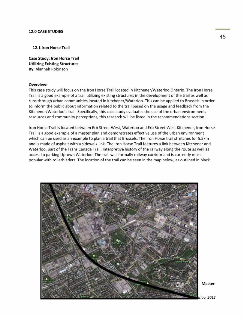
Overview: This case study will focus on the Iron Horse Trail located in Kitchener/Waterloo Ontario. The Iron Horse Trail is a good example of a trail utilizing existing structures in the development of the trail as well as runs through urban communities located in Kitchener/Waterloo. This can be applied to Brussels in order to inform the public about information related to the trail based on the usage and feedback from the Kitchener/Waterloo’s trail. Specifically, this case study evaluates the use of the urban environment, resources and community perceptions, this research will be listed in the recommendations section. Iron Horse Trail is located between Erb Street West, Waterloo and Erb Street West Kitchener, Iron Horse Trail is a good example of a master plan and demonstrates effective use of the urban environment which can be used as an example to plan a trail that Brussels. The Iron Horse trail stretches for 5.5km and is made of asphalt with a sidewalk link. The Iron Horse Trail features a link between Kitchener and Waterloo, part of the Trans Canada Trail, Interpretive history of the railway along the route as well as access to parking Uptown Waterloo. The trail was formally railway corridor and is currently most popular with rollerbladers. The location of the trail can be seen in the map below, as outlined in black.
Master

PLAN 414/REC 425, School of Planning, University of Waterloo, 2012
46 Plan: A Master plan (or Management Plan) is a document which outlines all the management practices that have, are, and will occur on the trail, including history, land agreements, and future possibilities. The following is the URL to access the master plan to the Iron Horse Trail and other surrounding trails: http://www.city.waterloo.on.ca/Portals/57ad7180-c5e7-49f5-b282 c6475cdb7ee7/RL_documents/rlsmp10Oct2008.pdf This URL contains the master plan for Iron Horse trails. The website lists all the facilities located on the trail and how the trail is maintained and developed over time. This is a useful resource for the city to create and publish as it enables people to easily see and understand the issues associated with the trail, outline potential plans and techniques oriented towards solving problem. This creates transparency amongst the city and community members. Transparency enables open lines of communication in order to establish understanding the future of the trail on which they can comment to further improve the trail or maintenance of the Iron Horse Trail. City of Kitchener/Waterloo Website:
Figure 2: City of Kitchener/Waterloo Region (2012). www.city.waterloo.on.ca
The City of Kitchener/Waterloo (2012) has a website page dedicated to their city parks and is used to inform tourists on local trails, trail use and maintenance. The website provides maps of the location of the trail, possible trail routes as well as quick historical facts about the surrounding area. This is a useful resource to promote trails in the Kitchener/Waterloo community and more specifically the Iron Horse Trail. As a recommendation for further promotion for the Iron Horse Trail, the City of Kitchener/Waterloo should develop an informative website specifically dedicated to the Iron Horse Trail with photo’s, promotional videos, historical informational and primary uses of the trail.
Figure 3: Explore Kitchener/Waterloo Tourism Website (2012). www.explorewaterlooregion.com/tours-and-trails/cycling-trails
A second website, as seen in Figure 3: Explore Kitchener/Waterloo Tourism Website (2012) was developed to provide tourism related information to residents and visitors to the Kitchener/Waterloo area. This gives less information about the park and trail, but more pictures for potential visitors and tourists to look at. This website gives a brief overview of the history of the Iron Horse Trail and the predominate purpose of the trail however the information is limited and directs website visitors to Kitchener Community Services which is located at City Hall or the Charles Street Transit Terminal. This lack of accessible detailed information may deter residents and tourists to further seek out information about this trail which may hinder the trail usage over time. Community Perceptions of Iron Horse Trail: In early February, an article was printed in the Kitchener Chronicle (local Kitchener newspaper) which outlined a possible relocation of the Iron Horse Trail for the accommodation of a new residential condo building. The article outlined several residential opinions about the trail location, several comments included: “The Iron Horse Trail belongs to the citizens of Waterloo, It’s been a part of our history” -Pauline Shang Au “The proposal for moving the Iron Horse Trail are just absurd. I am a big supporting of having
PLAN 414/REC 425, School of Planning, University of Waterloo, 2012
47 development around (transit station areas), having said that, this development is not appropriate for the uptown in its present form. There is no way to have a vibrant streetscape if you have a development that is parking-oriented” -Michael Druker “What I’m concerned about is that it is very difficult to access Park Street right now at the Iron Horse Trail and I know traffic is going to be diverted to King Street” -Diane Freeman The public opinion in the implementation or relocation of a trail has a significant impact on building decisions and can have a ripple effect on the local community. This has a direct connection with the Brussels Trail as the implementation of a trail through the city and along the river will have a direct impact on the local community. In another forum for residents and tourists to leave their impression of the Iron Horse Trail, there is a website where people can record their experience while on the trail and the significance the trail has for several community members. A few quotes outlined below demonstrate the importance this trail has for community members. “The trail connects my workplace and the urban environment around my work place. The trail is a way of keeping a creative tension open, so I can feel a deep connection between the two communities of Kitchener/Waterloo community” -Christa Van Daele “This trail is a symbol of the two cities in collaborating and cooperating to create something that will join the two cities in unity. It is seen as a natural corridor to feel connected to nature while still in an urban area. -Joan Mckinnon The public opinion around the Kitchener/Waterloo area support the Iron Horse Trial and value the trail as a natural extension of the Kitchener/Waterloo community. The above newspaper article and voice recordings of community member’s perceptions of the Iron Horse Trail are important factors when deciding major changes. The focus of community member input can be translated to the Brussels trail and the numerous community member input and perceptions that need to be collected by the City of Brussels in order to provide a meaningful trail that is available to all local residents and tourists. Recommendations The Iron Horse Trail has several direct links to the Brussels Trail that is looking to be implemented by the village of Brussels. Similar to the Brussels community, the Iron Horse Trail uses a pre-existing rail way as a part of the community and urban landscape also both communities’ involved strong public opinions with desired input on the trail development and implementation. The following recommendations for the Iron Horse Trail can have direct application to the Brussels community and trail plan. 1) It is recommended that the City of Brussels transparency in terms of trail development and implementation in order to maintain community support and interest 2) Based on the information provided on the City of Kitchener/Waterloo website about the Iron Horse Trail, It is recommended that the City of Brussels takes an active approach in using easy to access materials such as web pages to inform public of trail developments

PLAN 414/REC 425, School of Planning, University of Waterloo, 2012
48 3) As seen with public opinions regarding the Iron Horse Trail, It is recommended that the City of Brussels survey community members and stakeholders about the importance and impact a trail would have on the community prior to the implementations so public opinion is considered before construction takes place. 4) It is also recommended that the City of Brussels revisit city master plans and zoning by laws in order to determine future development and construction in order to minimize trail relocation and negative publicity prior to the development of the Brussels Trail
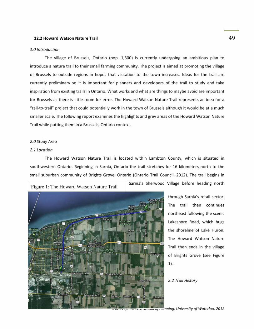
PLAN 414/REC 425, School of Planning, University of Waterloo, 2012
49
Figure 1: The Howard Watson Nature Trail
12.2 Howard Watson Nature Trail 1.0 Introduction
The village of Brussels, Ontario (pop. 1,300) is currently undergoing an ambitious plan to
introduce a nature trail to their small farming community. The project is aimed at promoting the village
of Brussels to outside regions in hopes that visitation to the town increases. Ideas for the trail are
currently preliminary so it is important for planners and developers of the trail to study and take
inspiration from existing trails in Ontario. What works and what are things to maybe avoid are important
for Brussels as there is little room for error. The Howard Watson Nature Trail represents an idea for a
“rail-to-trail” project that could potentially work in the town of Brussels although it would be at a much
smaller scale. The following report examines the highlights and grey areas of the Howard Watson Nature
Trail while putting them in a Brussels, Ontario context.
2.0 Study Area
2.1 Location
The Howard Watson Nature Trail is located within Lambton County, which is situated in
southwestern Ontario. Beginning in Sarnia, Ontario the trail stretches for 16 kilometers north to the
small suburban community of Brights Grove, Ontario (Ontario Trail Council, 2012). The trail begins in
Sarnia’s Sherwood Village before heading north
through Sarnia’s retail sector.
The trail then continues
northeast following the scenic
Lakeshore Road, which hugs
the shoreline of Lake Huron.
The Howard Watson Nature
Trail then ends in the village
of Brights Grove (see Figure
1).
2.2 Trail History

PLAN 414/REC 425, School of Planning, University of Waterloo, 2012
50 The initial idea for a natural trail within the Sarnia area began in 1983 by the Lambton Wildlife
Incorporated (LWI) community group (Lambton Wildlife Inc., 2010). The group had begun to advocate
for the trail following the decision by the Canadian National Railway (CN) to abandon the railway
corridor that ran from Sarnia northward to such communities as Thedford, Ontario. The LWI’s appeal
was accepted by the Sarnia councilors and the beginning of a three-year trial period was to start in 1988
(Lambton Wildlife Inc., 2010). However, this trial period would be on the condition that the LWI would
fully fund the venture themselves. Through donations and fundraising, $24,000 was raised for the “rail-
to-trail” project and the three-year trial began in 1988 as planned (Lambton Wildlife Inc., 2010). The
“trial” label was lifted one year later after outpouring support from the community and the trail was
officially labeled the Howard Watson Nature Trail, in honor of a former Sarnia councilor who backed the
project (Lambton Wildlife Inc., 2010; Bluewater, 2008).
2.3. Materials and Development
One of the interesting aspects of the Howard Watson Nature Trail is that it combines several
trail varieties into one while also bringing civilization and nature together. Along the urban portion of
the trail, there are stretches of pavement, which are used to encourage bicycle use in the city. However,
as you get further outside of the Sarnia region the trail turns to more of a natural surface. The natural
surface ranges anywhere from gravel
(see Figure 2) to dirt to grass as the trail
pass through the Lambton County
countryside space (Ontario Trail
Council, 2012)..
In terms of miscellaneous
materials on the Howard Watson Trail,
the designers have ingeniously created
the trail with the its past use as a
railway visible. In the countryside
portion of the trail all of the waterway crossings are created to
incorporate the old railway’s trestles (see Figure 3). This is an important reminder of the previous use of
the area and creates a rustic sense. The railway tracks themselves have been removed from the route,
however there are still areas where the path that they would have taken can still be seen.
Figure 2: Gravel Material

PLAN 414/REC 425, School of Planning, University of Waterloo, 2012
51
3.0 Areas of Success
3.1 Accessibility
The Howard Watson Nature Trail offers Lambton County residents, whether they are in Sarnia or
from one of the surrounding small communities, ample opportunities of use. Access points can be found
along the heavy traffic flow roads such as; Confederation Line, London Road, Michigan Avenue and
Lakeshore Road. This set up is crucial to the trail’s success as it ensure that a high percentage of the
population comes in contact with the trail regularly and is thus aware of its’ existence. Access points on
main roads also helps to encourage residents to use the trail for recreation and leisure as it is close to
home and is in areas frequented regularly. If the access points to the trail were to be located in remote
or isolated areas it may deter potential users because of the unfamiliarity of the access points or due to
distance.
Figure 3: Old Railroad Bridge on Howard Watson Nature Trail

PLAN 414/REC 425, School of Planning, University of Waterloo, 2012
52
3.2 Setting Variation/Adaptability
One of the unique features of the Howard Watson Nature Trail is changing landscape, urban to
rural, that follows the 16 kilometer trail (Tourism Sarnia-Lambton, 2012). Beginning in the city limits of
Sarnia, the trail quickly transitions into the urban center of the city (see Figure 4). The trail at this point is
relatively bike friendly as it begins with a flat dirt material before moving onto concrete in the city
center. This could be seen as an attempt to encourage bicycle use on the portion of the trail that is
located in the urban center. As the trail continues onwards it begins to once again leave the urban
environment for the rural setting. As the Howard Watson Nature Trail heads out of the city, the trail
transitions back to the dirt surface it began with. Continuing northward towards the community of
Brights Grove the trail becomes more hazardous for bikes due to the wild nature of the environment
surrounding the trail. However, walking
is a perfect option for this section of the
trail as it offers comforting natural views
and is accessible to pedestrians. Each
portion of the trail offers a different
focus however, combined together the
Howard Watson Natural Trail provides a
bit of everything for its users.
4.0 Areas of Concern
4.1 Trail Maintenance
Recently, path goers have raised the issue of trash on the Howard Watson Nature Trail
(Marshall, 2012). Users have reported litter sprawled across the path and in the vegetation as well as
dog feces not picked up and left on the path (Marshall, 2012). Since the path’s inception in 1988 the City
of Sarnia has taken responsibility for the trail’s maintenance (Lambton Wildlife Ltd., 2010). The recent
trash problems have brought the City of Sarnia’s commitment to the trail in question. If maintenance is
not of concern to the city than there is a need for other parties such as volunteer groups to take control
Figure 4: Howard Watson Trail, Downtown Sarnia

PLAN 414/REC 425, School of Planning, University of Waterloo, 2012
53 of the duties. Efforts are being taken by the community to help clean up the trail such as annual
sponsored community clean ups in which citizens take to the trail and pick up trash.
4.2 Criminal Activity
The Howard Watson Nature Trail has also experienced, although a small amount, crime on its
path. There have been incidents involving women being attacked by perpetrators on the trail when they
are alone although it is not a reoccurring theme. Other criminal activity such as trespassing on private
property (see Figure 5), narcotics, underage drinking, and vandalism have appeared on the trail’s route
since its inception. It is easy to see why there is such an array of criminal activity on the Howard Watson
Nature Trail. The trail, as mentioned, stretches for 16 kilometers however very few of that 16 kilometers
is in urban areas where the trail is visible,
with only 6 kilometers of the 16 kilometers is
in an urban space (Ontario Trail Council,
2012). There are many stretches of the trail
that are secluded and not adequately lit
which draws criminal activity, as there is a
minimal chance of anyone seeing the events
occurring.
5.0 Application to Brussels, Ontario
The Howard Watson Nature Trail offers multiple suggestions to the town of Brussels when
considering a nature trail, as well as some cautious warnings. Much like the Howard Watson Nature
Trail, the trail in Brussels will cross both urban and natural environments. The key to making such a
diverse trail work is ensure that the transition from one environment to another is a smooth one that
does not make the users feel unsure or uncomfortable. The Howard Watson Nature Trail accomplishes
this perfectly as the trail enters the urban center of Sarnia from the surrounding agricultural lands.
Developers of the Howard Watson Nature Trail ensured that the trail would penetrate through some of
the busiest districts of Sarnia without having to compete with the constant traffic. This is done so by
putting the trail away from the roads, such as cutting through residential properties, rather than having
Figure 5: No Trespassing Sign on Private Property

PLAN 414/REC 425, School of Planning, University of Waterloo, 2012
54 them crisscrossing and running parallel with the main roads. Although Brussels is significantly smaller
than Sarnia and the traffic is not nearly as heavy, pedestrian and automobile interaction is important to
consider. When Brussels trail users enter the urban portion of the trail coming from the natural portion
it will be important to ensure that they are not concentrated on Turnberry St. as it receives the heaviest
traffic flow of Brussels and senior citizens may feel weary walking along side it. Having the trail
emphasize the quieter back streets seems to be the proper method.
One of the aspects that Brussels should take away from the Howard Watson Nature Trail that
could head as a warning would be the aforementioned maintenance. As previously explained
maintenance of the Howard Watson Nature Trail seems to be lacking at times, which is unacceptable to
the community. As it currently stands the Howard Watson Nature Trail has a joint volunteer and
municipality agreement in regards to the maintenance but it seems to be debatable regarding efficiency.
The town of Brussels has indicated that they will almost certainly rely on volunteers to take care of the
maintenance of the new nature trail. Based on the evidence seen in Sarnia, a city of 75,000, regarding
the lack of efficient upkeep one has to worry how a town of just over 1,000 people will respond to their
town’s trail. While visiting the potential sites in the town of Brussels it became apparent that there was
already evidence of vandalism that had failed to be cleaned up in areas (i.e. Logan’s Mill). It would be in
the town’s best interest for a contract to be signed with a local/regional maintenance company in order
to ensure the proper attention will be given to the nature trail when its implemented. A well-maintained
trail is an attractive trail in the eyes of trail goers.
Perhaps one of the best ideas for Brussels to take away from the Howard Watson Nature Trail
regards the implementation period. As mentioned the Howard Watson Nature Trail took an
implementation approach of a trial basis in order to judge the viability and popularity of the trail in the
community. This should be something for the village of Brussels to consider. It would be recommended
to divide the project into phases (e.g. 3 or 4) over a designated period. This is recommended, as a trail
project such as the one being explored right now could be a large financial gamble on a small
community such as Brussels. By implementing the project in phases over a designated period of time it
would allow for funds to be collected and distributed in intervals instead of putting all the financials into
one go of things. The phase implementation technique also allows the village to pull out of the project at
anytime if they feel their financials will not be recovered from the project. This would not be able to
occur on a trail project that is built in one phase, as all of the financials would be laid down in a lump

PLAN 414/REC 425, School of Planning, University of Waterloo, 2012
55 sump. For a small village such as this, there is not an endless supply of money so the council needs to be
smart when spending it. If the project proves to be a flop in terms of revenue and tourism it is important
for them to be able to stop the financial bleeding early on.
6.0 Conclusion
Although not identical in terms of the project, the Howard Watson Nature Trail offers some
suggestions and some warnings to the developers of the Brussels trail. Variation in landscape is
inevitable and transition is important for trail users. Developing a plan that matches that of the project’s
available finances is important to ensure that costs are covered and that the project is the right fit for
the community. On the other hand it is important to have a concrete plan in terms of maintenance or
run the risk of questionable maintenance practices, as seen on the Howard Watson Nature Trail.
Without question the trail in Brussels will need to go through an initial trial and error period in the
beginning to get the fit however any outside influence it can receive could prove to be invaluable.
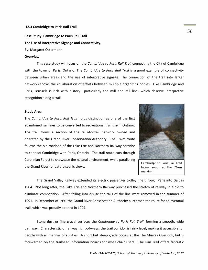
PLAN 414/REC 425, School of Planning, University of Waterloo, 2012
56 12.3 Cambridge to Paris Rail Trail Case Study: Cambridge to Paris Rail Trail
The Use of Interpretive Signage and Connectivity.
By: Margaret Ostermann
Overview
This case study will focus on the Cambridge to Paris Rail Trail connecting the City of Cambridge
with the town of Paris, Ontario. The Cambridge to Paris Rail Trail is a good example of connectivity
between urban areas and the use of interpretive signage. The connection of the trail into larger
networks shows the collaboration of efforts between multiple organizing bodies. Like Cambridge and
Paris, Brussels is rich with history –particularly the mill and rail line- which deserve interpretive
recognition along a trail.
Study Area
The Cambridge to Paris Rail Trail holds distinction as one of the first
abandoned rail lines to be converted to recreational trail use in Ontario.
The trail forms a section of the rails-to-trail network owned and
operated by the Grand River Conservation Authority. The 18km route
follows the old roadbed of the Lake Erie and Northern Railway corridor
to connect Cambridge with Paris, Ontario. The trail route cuts through
Carolinian Forest to showcase the natural environment, while paralleling
the Grand River to feature scenic views.
The Grand Valley Railway extended its electric passenger trolley line through Paris into Galt in
1904. Not long after, the Lake Erie and Northern Railway purchased the stretch of railway in a bid to
eliminate competition. After falling into disuse the rails of the line were removed in the summer of
1991. In December of 1991 the Grand River Conservation Authority purchased the route for an eventual
trail, which was proudly opened in 1994.
Stone dust or fine gravel surfaces the Cambridge to Paris Rail Trail, forming a smooth, wide
pathway. Characteristic of railway right-of-ways, the trail corridor is fairly level, making it accessible for
people with all manner of abilities. A short but steep grade occurs at the The Murray Overlook, but is
forewarned on the trailhead information boards for wheelchair users. The Rail Trail offers fantastic
Cambridge to Paris Rail Trail facing south at the 76km marking.

PLAN 414/REC 425, School of Planning, University of Waterloo, 2012
57 opportunities for hiking and biking; cross-country skiing is popular along the trail during the winter
months.
Three points grant access to the trail, each featuring: parking, information kiosks, garbage bins,
and –not operated by the Grand River Conservation
Area but available nearby- food and washroom
facilities. The access points are located in:
Cambridge (The Canadian General Tower Trailhead),
Glen Morris (at the old railway station site, Forbes
St.), and Paris (Jean Rich Foundation Trailhead).
Connectivity
Not merely an 18km stretch of trail, the Cambridge to Paris Rail Trail contributes to four larger
trail networks. In Cambridge, the rail trail is incorporated into the larger Cambridge Heritage Trail
Network. Portions of the Cambridge to Paris Rail Trail also form sections of the Grand Valley Trail
system, a 260km footpath from Lake Erie to the town of Alton, near Orangeville, Ontario.
Most publicized is the Cambridge to Paris Rail Trail’s inclusion in the Hamilton-Brantford-
Cambridge Trails network. The network began unintentionally, but came to link four separate trail
projects to form a 77km long network. The Hamilton to Brantford Rail Trail is considered the beginning
of the network. Undertaken by Hamilton Region and the GRCA, it forms the first 32km of the network.
The Gordon Glaves Memorial Pathway forms the next section, winding through the City of Brantford.
The network then continues from Brantford to Paris on the S.C. Johnson Trail which was installed by the
GRCA in 1996 to complete the network. The Cambridge to Paris Rail Trail forms the final leg of the trail
network.
The Canadian General Towers Trailhead, Highway #24, Cambridge, Ontario.

PLAN 414/REC 425, School of Planning, University of Waterloo, 2012
58
Creating national exposure, the Hamilton-Brantford-Cambridge Trail Network –and Cambridge
to Paris Rail Trail respectively- has been formally incorporated into the Trans Canada Trail. Without
owning or operating any trail, the Trans Canada Trail instead compiles almost 400 individually operated
trails to form the world’s longest network of multi-use recreational trails.
Trail Interpretation
Crossing though an area rich with history and environmental value, the Cambridge to Paris Rail
Trail recognizes the area’s past and enhances the visitor experience with information boards at each of
the three trail access points. The four-sided kiosks are visually appealing with bright colours, pictures,
and grouped text boxes for quick reading.
The first panel pays appreciation to trail supporters, with a list of notable donors and a column
soliciting further support. The adjacent panel details the trail route and outlines the broader Hamilton-
Brantford-Cambridge Trail linkages. Upon the opposite side of the kiosk another two panels detail
historical and natural features. Forming an engaging collage of text,
pictures, timetables, and ticket stubs; the railway history of the trail is artfully presented.
Information is divided into two to three sentence paragraphs with supporting visual information. The
format provides quick, easy reading. Adjacent to the railway history, the final panel details the Grand
River Conservation Authority’s work, green initiatives, recreation
The Hamilton-Brantford-Cambridge network provides 77km of inter-urban trails. (Source: http://www.conservationhamilton.ca/Asset/iu_files/RailTrailBrochure.pdf)

PLAN 414/REC 425, School of Planning, University of Waterloo, 2012
59 opportunities and education programs. The format is similar to the railway history panel, with
multiple sub-sections of grouped information and photographs.
Each kilometre of the trail is marked, as part of the Hamilton-Brantford-Cambridge Trail
network. The distance markers provide both recognition of trail donors and a method for
Example of Trail Boards
tracking progress along the long trail.
Funding:
The Grand River Conservation Foundation is a sub-division of the GRCA, which acts to organize
and funnel donations from individuals, foundations, groups and businesses to GRCA projects. The
foundation raised $1.5 million to cover the land purchases and development costs for four rail-trail
projects (including the Cambridge to Paris Rail Trail) under the GRCA.
Cowan Foundation has made a three year (2010-2012), $75,000 contribution to help the GRCA
renew the 77km Hamilton-Brantford-Cambridge Trail network. This breaks down to $325 per year, per
kilometre of the trail network.
Mountain Equipment Co-op has also donated $15,000 towards the 77km network, for the
purpose of increasing and enhancing directional and interpretive signage. Both the Cowan Foundation
and Mountain Equipment Co-op mentioned in statements the importance of maintaining the trails at no
direct cost to the community.
PLAN 414/REC 425, School of Planning, University of Waterloo, 2012
60 Application to Brussels
Rail-Trail: The abandoned rail line through Brussels is blocked heading east (from Turnberry
Street) by industrial use. However, the west section of the rail line in Brussels is public property,
potentially linking to Bluevale and Wingham.
Connectivity: The trail’s connection in larger networks –particularly the Hamilton-Brantford-
Cambridge trail network- shows the promotional capabilities and usability inherited upon each
trail when part of a larger network. Partnership between cities, municipalities and the
conservation authority shows that a network is the incorporation of many divisions, not just the
burden of one organizing body. Finally, the entire network need not be created at once, but as a
compilation formed over many years.
Interpretation: It is important to examine and interpret the features the trail crosses to make
the most of the recreational experience. Historical and environmental information gives the
trail context and more memorable value. Collage-style information boards are visually
appealing and quick to read.
Financing: Generous support from businesses can provide significant lump donations.

PLAN 414/REC 425, School of Planning, University of Waterloo, 2012
61 12.4 Belleview Trail Case Study: Belleview Park Trail Tianna Burke Belleview Park, located in the heart of Sault Ste. Marie, is a good example of a master plan and
ways to advertise a trail that Brussels can use as an example. The Belleview Park trail stretches for 2.4km
and is approximately 17 hectares in size made of asphalt.
Stretching along the walkway are shops, workplaces, floral beds,
playgrounds, along the St. Mary’s River. The trail extends from
not only Belleview Park, but throughout the St. Mary’s River
towards the Sault Locks. The location of the park, which the trail
runs through, can be seen in the map below.
Master Plan:
A Master plan (or Management Plan) is a document which
outlines all the management practices that have, are, and will
occur on the trail, including history, land agreements, and
future possibilities.
The website:
(http://www.cityssm.on.ca/contentadmin/UserFiles/File/CityDepartments/PWT/MasterStrategyBellevu
e%20Park.pdf), contains the master strategy plan for Belleview Park and its trails. In this it lists all the
facilities located on the trail and how these will be maintained over time and developed. Under each of
these facilities and areas, issues are also listed and recommendations for solving them. This is a useful
Figure 1From the Ontario Trails Council
Website

PLAN 414/REC 425, School of Planning, University of Waterloo, 2012
62 item for the city (or owner of trail) to create as it enables people to easily see the issues that it faces and
potential ways to solve them. This creates transparency amongst the city and it’s citizens to the future
of the trail on which they can comment and include suggestions to. It also creates a document that
managers and city people can pass down through employee shifts, informing them of the vision for
future and present management.
Sault Ste. Marie Website:
The City of Sault Ste. Marie (2010) has a website page dedicated to their City parks and let’s
tourists know what they may find within them, especially Belleview as it’s the largest. On this website
there is no real promotion for people to use the walkway, whether they be tourists or for people who
work in the downtown area. Having a greater variety of pictures on the website may draw more people
to use these spaces.
A second
website, seen below, was found was by Tourism Sault Ste. Marie (2012). This gives less information
about the park and trail, but more pictures for potential visitors to look at. For this trail to be efficiently
Figure 2: City of Sault Ste. Marie (2010).
http://www.cityssm.on.ca/Open_Page.aspx?ID=512&deptid=1
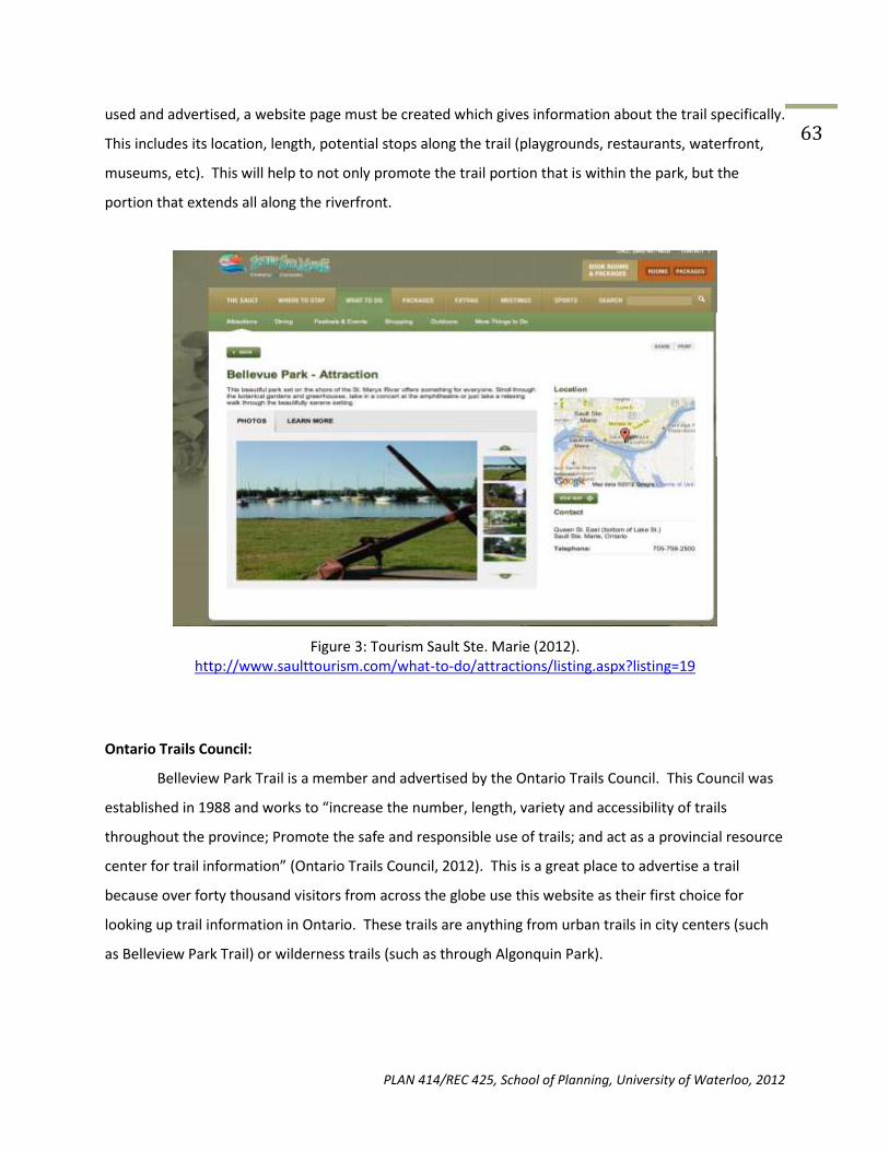
PLAN 414/REC 425, School of Planning, University of Waterloo, 2012
63 used and advertised, a website page must be created which gives information about the trail specifically.
This includes its location, length, potential stops along the trail (playgrounds, restaurants, waterfront,
museums, etc). This will help to not only promote the trail portion that is within the park, but the
portion that extends all along the riverfront.
Figure 3: Tourism Sault Ste. Marie (2012). http://www.saulttourism.com/what-to-do/attractions/listing.aspx?listing=19
Ontario Trails Council:
Belleview Park Trail is a member and advertised by the Ontario Trails Council. This Council was
established in 1988 and works to “increase the number, length, variety and accessibility of trails
throughout the province; Promote the safe and responsible use of trails; and act as a provincial resource
center for trail information” (Ontario Trails Council, 2012). This is a great place to advertise a trail
because over forty thousand visitors from across the globe use this website as their first choice for
looking up trail information in Ontario. These trails are anything from urban trails in city centers (such
as Belleview Park Trail) or wilderness trails (such as through Algonquin Park).

PLAN 414/REC 425, School of Planning, University of Waterloo, 2012
64
Figure 4: Viewing States from Ontario Trails Council (2012)
Viewers are able to look up trails based on region, activity, or city and find the trail that best suits them
to travel to, or to use within their own community.
Figure 5: http://www.ontariotrails.on.ca/
Social Media:
Belleview Park has taken the modern step to creating a facebook page to help advertise its Park and
trail. Although this page currently does not have a lot of information on it, it could be developed into an
efficient marketing tool. Festivals and park activities could be promoted through the facebook page, as
well as specials for restaurants along the routes.

PLAN 414/REC 425, School of Planning, University of Waterloo, 2012
65
Recommendations and conclusions: There are many things that Brussels can take from this case study of Belleview Park Trail in Sault Ste. Marie. - It is recommended that a management plan be created. This will help ensure trail transparency, maintenance and future plans are all accounted for. - It is recommended that a trail webpage be available on the Brussel’s city website. This will allow for promotion of the trail specifically. This can include a map of where it is, what it passes, and things to do along the trail. -It is recommended that Brussels trail be added to the Ontario Trails Association website. This will provide great promotion to the trail as there are a variety of people who use the site on a frequent basis. - It is recommended that other social media possibly be used. This is a modern technique, but can be useful for promoting local businesses along the trail or creating a photo-base.

PLAN 414/REC 425, School of Planning, University of Waterloo, 2012
66 12.5 Laurel Creek Conservation Area
Laurel Creek Conservation Area: A Case Study of Online Media and Promotion Matthew Rodgers February 5, 2012
Overview:
This case study will focus on the Laurel Creek Conservation Area Trail located in
Waterloo, Ontario. The Laurel Creek Conservation Area Trail is a good example of a park area
with excellent online resources designed to inform interested individuals of details regarding it.
This can be applied to Brussels in order to inform the public about information related to the
trail as well as encourage feedback from trail users, as a well-designed website can allow for all
of these things. Specifically, this case study evaluates the use of online media to promote the
trail. Resources related to this research will be listed in the Recommendations section.
Laurel Creek Conservation Area:
Images retrieved from www.grandriver.ca
Located in North Waterloo, Ontario, Laurel Creek Conservation Area offers three multi-
purpose trail loops. They are used for hiking/walking in the summers, and as cross-country ski
trails when conditions allow in the winter season. The area includes over 8km of trails in total,
running around the edge of a small lake. Canoeing and camping are also offered as activities at
the site.

PLAN 414/REC 425, School of Planning, University of Waterloo, 2012
67
Master Plan for Laurel Creek Conservation Area:
A Master plan (or Management Plan) is a document which outlines all the management
practices that have, are, and will occur on the trail, including history, land agreements, and
future possibilities.
Website URL: http://www.grandriver.ca/CurrentStudies/LaurelPlan2004_Complete.pdf
This URL contains the master plan for Laurel Creek Conservation Area. It includes
information regarding the physical conditions and biophysical resources of the site, existing
uses, management practices, issues/opportunities/stakeholder input, and a recommendations
& plan implementation section. This is a useful resource for municipality which owns and
operates a trail site to create, as it helps compile information regarding the issues that the
municipality faces associated with the trail, and outlines potential courses of action for problem
solving. It also provides a lasting vision for a trail system which can be referenced by future
legislators and by citizens as well.
Online Media used by Laurel Creek Conservation Area:
Ontario Trails Website:
http://www.ontariotrails.on.ca/trails-a-z/laurel-creek-conservation-area-trail
The Ontario Trails Council offers a web-space to protected areas in Ontario in order to
offer citizens a straight-forward, all in one database from which they can find information
regarding protected areas throughout the province. As search options on the website consist of
searching for a trail by region of the province and by city, this website would likely be used by
citizens curious as to discover what their local area has to offer in terms of trails, or who are
travelling to a region of the province and want to discover the trail options in that region.

PLAN 414/REC 425, School of Planning, University of Waterloo, 2012
68 Having a presence on this website could provide opportunities for people living outside of
Huron County to learn about the Brussels Trails’ existence.
Grand River Conservation Authority Website:
Image retrieved from http://www.grandriver.ca/index/document.cfm?Sec=27&Sub1=127&sub2=0
The Grand River Conservation Authority “manages water and other natural resources on
behalf of 39 municipalities and close to one million residents.” The authority’s website,
www.grandriver.ca, offers conservation areas pages on it website in order to promote
themselves by offering the public information regarding general characteristics of an area,
when trails can be used, etc. This site is among the first search results for Laurel Creek
Conservation Area when using the Google search engine, and the site is appropriately highly
detailed in terms of explaining what and where the conservation area is, the activities that can
be undertaken there, and other useful information for interested citizens. The option of having
information about the trail site in Brussels hosted on a local government agency’s could provide
credibility and easy access to information for citizens interested in finding out more about the
trail, though for the most part interested people will be searching for information about the

PLAN 414/REC 425, School of Planning, University of Waterloo, 2012
69 Brussels trail specifically when they visit such a site, meaning that the promotion opportunities
for such an arrangement are quite limited.
Recommendations:
-Having a high degree of search-ability of information regarded to a trail or conservation area is
key. Use Google search results wisely to ensure that information regarding the trail is easy to
find for interested parties.
-Use whatever connections available to Brussels in order to distribute detailed information
about the trail, most of which may be completely free to use. I suggest attempting to get
information regarding the trail hosted on sites such as that of the Maitland River Conservation
Authority: http://www.mvca.on.ca/, or perhaps other regional websites regarding recreation,
attractions, etc. Essentially, spread the information around as much as possible and with good
detail online, so as to make information very easy to find for those who are interested in it, and
present the information well.
-This process can include creating an official Facebook or Google + page, a Twitter account, or
hosting information on other websites such as that of the local municipality.
-Brussels is a rather small town with a rather small-scale walking trail idea. This idea fits within
the town’s ambitions well. Promoting the trail in a major way will probably be a waste of
resources; success for the trail is to create a valuable and attractive piece of long-term
infrastructure, but don’t treat low usage as a failure. It is a walking trail, not an amusement
park, so keeping the project and its goals in perspective and not overspending on the project is
a good idea. Provide a good spread of information for those who come seeking the information,
but pushing this information to a wider audience is not exactly necessary to the trail being
deemed a success.

PLAN 414/REC 425, School of Planning, University of Waterloo, 2012
70 12.6 Gordon Glaves Memorial Pathway
Case Study: Gordon Glaves Memorial Pathway and the use of a Multi-Use Trail/Bikeway
Implementation and Design Plan
By Melinda Liu (20281579)
Overview
This case study will focus on the Gordon Glaves Memorial Pathway, part of the Trans
Canada Trail located in Brantford, Ontario. The Gordon Glaves Memorial Pathway is a good
example of how to get started on designing and planning trails and/or bike ways prior to
implementation. This can be applied to Brussels in order to provide cost estimates, barriers to
overcome, attractions/destinations to include and how to implement the proposed routes.
Specifically, this case study evaluates the use of The City of Brantford’s Website and the Multi-
Use Trail/Bikeway Implementation and Design Plan. Resources related to this research will be
listed in the Recommendations section.
Study Area
The Gordon Glaves Memorial Pathway is located in downtown Brantford, Ontario, and
runs parallel to the Grand River (Ontario Trails Council, 2012). The Gordon Glaves Memorial
Pathway is one of the four trails that is part of The Hamilton-Brantford-Cambridge Trails
system. The Trails between Hamilton-Brantford-Cambridge are part of “Canada’s first fully,
developed, multi-use inter-urban trail system” (GRCA, n.d.), stretching approximately 80
kilometres, and has been formally recognized as being part of the Trans Canada Trail. The
Gordon Glaves Memorial Pathway was constructed in early 1990s. In 1993, the trail was named
after the late Gordon C. Glaves, a well known community volunteer (Ontario Trails Council,
2012). The main trail of the Gordon Glaves Memorial Pathway “is on top of a dyke built by the
GRCA in response to the flood of 1974” (Grand River Country, 2010; Ontario Trails Council,
2012; GRCA, n.d.), where it provides a beautiful scenic view of the Grand River. This section of
the trail is composed of tar and chip and connects to the Wilkes Dam, which is three kilometres
Northwest of the trail (Grand River Country, 2010). The two tiered Wilkes Dam provides a

PLAN 414/REC 425, School of Planning, University of Waterloo, 2012
71 spectacular view of the Grand River (Figure 1), however only minimal information was available
about the dam itself.
Gordon Glaves Memorial Pathway is approximately 12 kilometres in length. It begins in
Brantford Jaycees Trailhead, passes through Kanata Iroquois Village, Mohawk Chapel (a Six
Nations Historic Site), Brant’s Crossing and Earl Haig Park, Waterworks Park and ends at Wilkes
Dam (GRCA, n.d.; Hamilton Conservation Authority, n.d.). At Brant’s Crossing and Earl Haig Park,
there is an alternate route that provides access to an additional eight kilometres of trails which
leads to to Bell Homestead across from the Grand River (Hamilton Conservation Authority, n.d.;
GRCA, n.d.).
The surface of the trails are covered with stone dust or finer gravel, suitable for bicycles,
and some sections of the trail in Brantford are paved (GRCA, n.d.; GRCA, 2012).The majority of
the trail is accessible to wheelchair users (GRCA, 2012). Access has been provided to key points
along the trail. The trails allows bicycling and hiking opportunities, and cross-country skiing in
the winter months (GRCA, 2012). A warning is written specifically to the trail user that they
must be aware of the vehicular traffic as some sections of the trail transects with busy
roadways, and private laneways (GRCA, n.d.). The trail is owned, and maintained by the City of
Brantford (Grand River Country, 2010; Hamilton Conservation Authority, n.d.).
The City of Brantford’s Website
Figure 1. Close up view of the Wilkes Dam (danspic, n.d.).
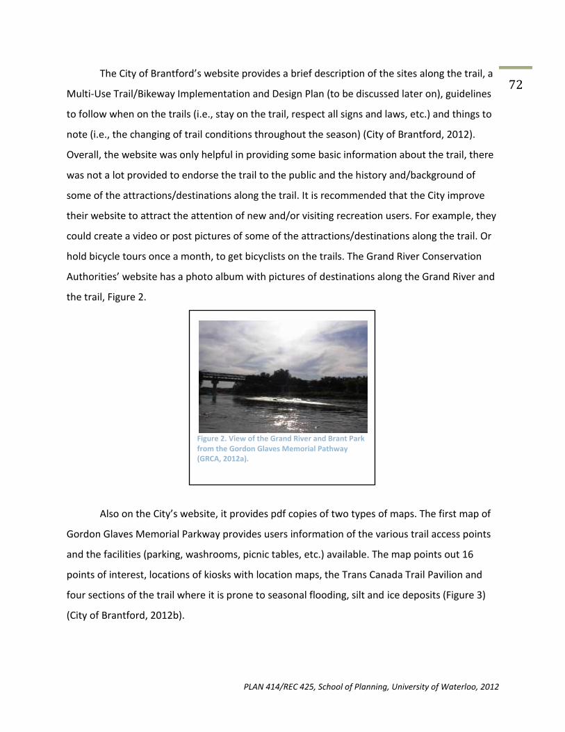
PLAN 414/REC 425, School of Planning, University of Waterloo, 2012
72 The City of Brantford’s website provides a brief description of the sites along the trail, a
Multi-Use Trail/Bikeway Implementation and Design Plan (to be discussed later on), guidelines
to follow when on the trails (i.e., stay on the trail, respect all signs and laws, etc.) and things to
note (i.e., the changing of trail conditions throughout the season) (City of Brantford, 2012).
Overall, the website was only helpful in providing some basic information about the trail, there
was not a lot provided to endorse the trail to the public and the history and/background of
some of the attractions/destinations along the trail. It is recommended that the City improve
their website to attract the attention of new and/or visiting recreation users. For example, they
could create a video or post pictures of some of the attractions/destinations along the trail. Or
hold bicycle tours once a month, to get bicyclists on the trails. The Grand River Conservation
Authorities’ website has a photo album with pictures of destinations along the Grand River and
the trail, Figure 2.
Also on the City’s website, it provides pdf copies of two types of maps. The first map of
Gordon Glaves Memorial Parkway provides users information of the various trail access points
and the facilities (parking, washrooms, picnic tables, etc.) available. The map points out 16
points of interest, locations of kiosks with location maps, the Trans Canada Trail Pavilion and
four sections of the trail where it is prone to seasonal flooding, silt and ice deposits (Figure 3)
(City of Brantford, 2012b).
Figure 2. View of the Grand River and Brant Park from the Gordon Glaves Memorial Pathway (GRCA, 2012a).
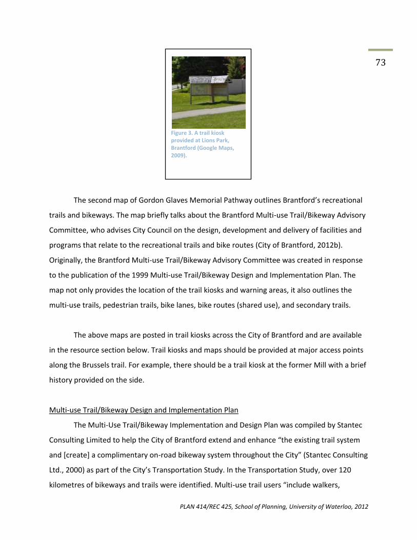
PLAN 414/REC 425, School of Planning, University of Waterloo, 2012
73
The second map of Gordon Glaves Memorial Pathway outlines Brantford’s recreational
trails and bikeways. The map briefly talks about the Brantford Multi-use Trail/Bikeway Advisory
Committee, who advises City Council on the design, development and delivery of facilities and
programs that relate to the recreational trails and bike routes (City of Brantford, 2012b).
Originally, the Brantford Multi-use Trail/Bikeway Advisory Committee was created in response
to the publication of the 1999 Multi-use Trail/Bikeway Design and Implementation Plan. The
map not only provides the location of the trail kiosks and warning areas, it also outlines the
multi-use trails, pedestrian trails, bike lanes, bike routes (shared use), and secondary trails.
The above maps are posted in trail kiosks across the City of Brantford and are available
in the resource section below. Trail kiosks and maps should be provided at major access points
along the Brussels trail. For example, there should be a trail kiosk at the former Mill with a brief
history provided on the side.
Multi-use Trail/Bikeway Design and Implementation Plan
The Multi-Use Trail/Bikeway Implementation and Design Plan was compiled by Stantec
Consulting Limited to help the City of Brantford extend and enhance “the existing trail system
and [create] a complimentary on-road bikeway system throughout the City” (Stantec Consulting
Ltd., 2000) as part of the City’s Transportation Study. In the Transportation Study, over 120
kilometres of bikeways and trails were identified. Multi-use trail users “include walkers,
Figure 3. A trail kiosk provided at Lions Park, Brantford (Google Maps, 2009).

PLAN 414/REC 425, School of Planning, University of Waterloo, 2012
74 runners, cyclists, people with mobility aids and in some locations in-line skaters. Users will be of
all ages, all levels of experience, and all levels of mobility” (Stantec Consulting Ltd., 2000).
The City of Brantford requested that major routes be proposed east-west and north-
south of the City in an attempt to connect neighbourhoods, connect major destinations (the
Grand River, Bell Homestead, etc), provide alternate routes to existing major routes, and
facilitate the crossing of major physical barriers (railways, Highway 403 and the Grand River).
The report proposed the creation of 12 primary routes, 14 neighbourhood routes and 12
connecting links in between the primary routes (Stantec Consulting Ltd., 2000). Each route was
examined in depth, it included a description of the route, the destinations/attractions along
that route, barriers crossed, connections to other routes, bikeway types and length of route.
The proposed Brussels trail should have a study, like Brantford’s, to make sure that all the
barriers are addressed and attractions are highlighted.
The report includes a table of the unit costs of construction for the proposed multi-use
trails and bikeway routes. The table includes the cost to pave existing shoulders to provide a
bike lane to the construction of new multi-use trails. The table is provided in the resources
section. All numbers are based upon the 1999 dollar and is extremely detailed. This
construction cost table may be helpful in terms of estimating the budget required in order to
implement a trail in Brussels.
In regards to the implementation plan, Stantec Consulting Ltd., recommends that the
City prioritize the projects, based upon the following criteria: road construction opportunities,
ease of implement, public comments, public support and profile and comments from the
Community Advisory Committee and Technical Steering Committee. They recommended that
the first priority would be to complete the Trans Canada Trail route, implement the least
expensive sections, and have the Council’s full commitment in order for the plans to move
forward (Stantec Consulting Ltd., 2000). There has been no follow up or review plans released
to the public in relation to the establishment of all of the proposed routes. Therefore, it is

PLAN 414/REC 425, School of Planning, University of Waterloo, 2012
75 unclear how much routes from the report was actually implemented or how much the actual
construction costs deviated from the estimated costs. Although when comparing the Gordon
Glaves Memorial Pathway - Brantford Recreational Trails and Bikeways map with the proposed
trails and bikeway map, it appears that the City had implemented some of the top priority
routes in the last 11 years. The City’s 2008 Transportation Study only specified their plans and
goals for the public bus transit system for the next 10 years, with no mention of the trails or
bikeways. An updated report should be released, discussing the results of the original report.
Recommendations & Conclusions
It is recommended that:
● Kiosks with location maps and/or background information be set up throughout the
various access points of the Brussels trails;
● Access points should be clearly marked with signs;
● Floodplain areas should have warning signs;
● Brantford’s construction cost table may be used as a method to estimate approximate
construction costs;
● Have a website or webpage that introduces and talks about the Brussels trail;
● A trail map be provided on the website;
● Actively endorse the trail by holding events;
● Background and history of destinations/attractions be provided online; and
● Have pictures and/or videos that represent Brussels.
In conclusion, the City of Brantford has some good ideas, like the Multi-use
Trail/Bikeway Implementation and Design Plan, trail kiosks, access points to the trail and
warning signs in floodplain areas. However, there are lots that the City could do to help ensure
the trails and bikeways’ success. For example, incorporating the trails and bikeways into the
Transportation Study and reviewing the study every 5-10 years. Or holding a scavenger hunt on
the trail for youths, so they have an opportunity to explore various sections of the trail for
themselves.
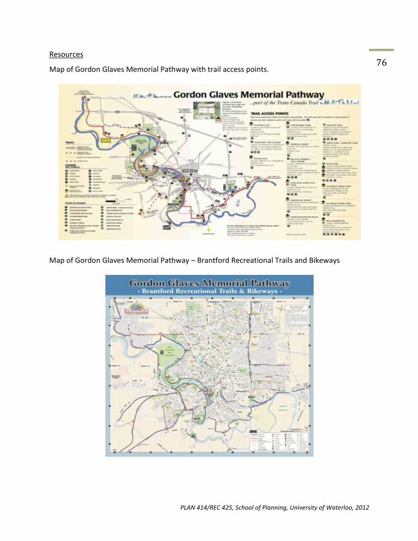
PLAN 414/REC 425, School of Planning, University of Waterloo, 2012
76 Resources
Map of Gordon Glaves Memorial Pathway with trail access points.
Map of Gordon Glaves Memorial Pathway – Brantford Recreational Trails and Bikeways

PLAN 414/REC 425, School of Planning, University of Waterloo, 2012
77 Table of Construction Costs
PLAN 414/REC 425, School of Planning, University of Waterloo, 2012
78
13.0 REFERENCES
Ashbaugh, B.L. (1971). Trail planning and layout. New York: National Audubon Society, Nature
Centre Planning Division.
Bluewater Trails. (2008, August 12). Bluewater trails. Retrieved from
http://www.bluewatertrails.com/trail-system.html.
British Columbia MTI (2011). British Columbia Ministry of Transportation Infrastructure:
Construction and rehabilitation cost guide. Retrieved from
http://www.th.gov.bc.ca/publications/const_maint/110121_Cost_Guide.pdf
Canadian Encyclopedia, The. (2012). Grand Trunk Railway of Canada. Retrieved on March 28,
2012, from http://www.thecanadianencyclopedia.com/articles/grand-trunk-railway- of-
canada
City of Brantford (2000). Multi-use trail/bikeway implementation and design plan. Retrieved
From http://www.brantford.ca/Parks%20and%20Trails%20%20Documents/
Bikeway%20Implementation%20and%20Design%20Plan%20-%20complete%
20for%20internet.pdf
City of Cambridge (2010). Trails master plan. Retrieved from
http://www.cambridge.ca/relatedDocs/Trails%20Master%20Plan%20FinalReport%2023July2010
Danspic (n.d.). Panoramio - Photo of Wilkes Dam. Panoramio - Photos of the World. Retrieved March 5, 2012, from http://www.panoramio.com/photo/10506840
FAO. (2002). Impacts of Dams on Rivers. Retrieved on March 23, 2012, from:
http://www.fao.org/docrep/005/y3994e/y3994e0i.htm
Google Maps (2009). Lions Park. Google Inc. Retrieved March 10, 2012, from http://maps.google.ca Grand River Conservation Authority (2012a). Brant Park Photo Album. Grand River Conservation Authority. Retrieved February 29, 2012, from http://www.grandriver.ca/index/document.cfm?Sec=27&Sub1=121&Sub2=1

PLAN 414/REC 425, School of Planning, University of Waterloo, 2012
79 Grand River Conservation Authority (n.d.). Explore the Hamilton-Brantford-Cambridge Trails. Grand River Conservation Authority. Retrieved March 3, 2012, from http://www.grandriver.ca/trails/HBCTrails06.pdf Grand River Conservation Authority (2012b). Grand River Trails. Grand River Conservation Authority. Retrieved March 2, 2012, from http://www.grandriver.ca/index/document.cfm?Sec=21&Sub1=0&sub2=0 Grand River Country (2010). Gordon Glaves Memorial Pathway (Waterworks Park Section) - Brantford. Grand River Country. Retrieved February 29, 2012, from http://www.grandrivercountry.com/trails/traildescription.aspx?trail=16
Hamilton Conservation Authority (n.d.). Explore the Hamilton-Brantford-Cambridge Trails. Hamilton Conservation Authority. Retrieved March 4, 2012, from http://www.conservationhamilton.ca/Asset/iu_files/RailTrailBrochure.pdf
Huron County. (2012). Huron county official plan. Retrieved from
www.huroncounty.ca/plandev/../Huron_County_Official_Plan.pdf
Huron County. (Designer). (2012). Huron county interactive mapping. [Web Map]. Retrieved from
http://gis.huroncounty.ca/imf/imf.jsp?site=Huron_County.
Lambton Wildlife Inc. (2010). Lambton wildlife projects. Retrieved from
http://www.lambtonwildlife.com/Projects-LWI.htm.
Maitland Valley Conservation Authority. (2012). Brussels Conservation Area. Retrieved on March
6, 2012, from http://www.mvca.on.ca/programs_conservation_bca.php
Marshall, D. (2012, February 12). Show some respect for howard watson trail. The Sarnia
Observer. Retrieved from http://www.theobserver.ca/ArticleDisplay.aspx?e=3462103.
Municipality of Huron East (2012). Brussels Public Library. Retrieved on March 2, 2012, from
http://www.huroneast.com/index.php?sltb=heritage&loc=57
Municipality of Huron East Official Plan Land Use Map (2009). Brussels and Grey Wards.
Produced by the County of Huron Planning and Development Department, updated
September 2009. Retrieved from http://www.huroneast.com/mn_pges/int_maps/maps
/BRU%20SCH-B%20Sep2009.pdf
North Huron (25 February 2010). Brussels Library. Retrieved on March 27, 2012, from
http://www.northhuron.on.ca/index.php?view=article&catid=69%3Abrussels&id=570%3
Abrussels-library&format=pdf&option=com_content&Itemid=88

PLAN 414/REC 425, School of Planning, University of Waterloo, 2012
80
Ontario Federation of Snowmobile Clubs. (2011). Landowner appreciation form. Retrieved from
http://www.ofsc.on.ca/about-us/ofsc-programs/landowners.html
Ontario Trails Council (2012). Gordon Glaves Memorial Pathway. Ontario Trails Council. Retrieved February 23, 2012, from http://www.ontariotrails.on.ca/trails-a-z/gordon-glaves-memorial-pathway/
Ontario Trail Council. (2012). Howard watson trail. Retrieved from
http://www.ontariotrails.on.ca/trails-a-z/howard-watson-trail/.
Parks-Mintz, Carolyn. 2010. Brussels – Honouring the Past, Shaping the Future.
RTC (2007). Rail-to-Trails Conservancy: plan, design, build toolbox. Retrieved from
http://www.railstotrails.org/ourWork/trailBuilding/toolbox/informationSummaries/plandesignb
uild.html
Saitta, S. (2011, March 1). Concrete, asphalt, gravel. Parks & Rec Business, Retrieved from
http://www.northstarpubs.com/articles/prb/concrete-asphalt-gravel
Stantec Consulting Limited. (March 23, 2000). City of Brantford Multi-Use Trail/Bikeway Implementation and Design Plan. Stantec Consulting Limited.
http://www.brantford.ca/Parks%20and%20Trails%20%20Documents/Bikeway%20Imple mentation%20and%20Design%20Plan%20-%20complete%20for%20internet.pdf
Tourism Sarnia-Lambton. (2012, March 9). Howard watson nature trail connection. Retrieved from
http://www.tourismsarnialambton.com/main/ns/5/doc/103/search//orderby/
NAME/sort//seek//totalrows//pos/4/area/.