walker street public housing renewal program - planning · walker street public housing renewal...
TRANSCRIPT

Walker Street Public Housing Renewal Program
Amendment C158 to the Darebin Planning Scheme
Traffic Engineering Evidence Statement to Social Housing Renewal Standing Advisory Committee
Date of Statement: 22 September 2017 Date of Inspection: 17 September 2017
Prepared For the Applicant: Department of Health and Human Services Instructed By: Norton Rose Fulbright
Reference: G22495A1_Northcote
IN THE MATTER OF AMENDMENT C158 TO THE DAREBIN PLANNING SCHEME RELATING TO THE WALKER STREET PUBLIC HOUSING RENEWAL PROGRAM
STATEMENT TO THE ADVISORY COMMITTEE BY JASON LEE WALSH, TRAFFIC ENGINEER
Amendment C158 Walker Street Public Housing Renewal Program: Amendment C158 to the Darebin Planning Scheme
G22495A1_Northcote
STATEMENT TO THE ADVISORY COMMITTEE BY JASON LEE WALSH, TRAFFIC ENGINEER
Amendment C158 to the Darebin Planning Scheme
at
Walker Street Public Housing Renewal Program
Our Reference: G22495A1_Northcote
COPYRIGHT: The ideas and material contained in this document are the property of Traffix Group (Traffix Group Pty Ltd – ABN 32 100 481 570, Traffix Survey Pty Ltd – ABN 57 120 461 510, Traffix Design Pty Ltd – ABN 41 060 899 443). Use or copying of this document in whole or in part without the written permission of Traffix Group constitutes an infringement of copyright.
LIMITATION: This report has been prepared on behalf of and for the exclusive use of Traffix Group’s client, and is subject to and issued in connection with the provisions of the agreement between Traffix Group and its client. Traffix Group accepts no liability or responsibility whatsoever for or in respect of any use of or reliance upon this report by any third party.

Amendment C158 Walker Street Public Housing Renewal Program: Amendment C158 to the Darebin Planning Scheme
G22495A1_Northcote Page i
Table of Contents 1 Introduction ........................................................................................................................ 3
2 History of Amendment ........................................................................................................ 4
3 Amendment C158 ............................................................................................................... 5
3.1 General .......................................................................................................................................... 5
3.2 Potential Development Yield ........................................................................................................ 5
3.3 Car Parking .................................................................................................................................... 5
3.4 Access and Internal Road Network ............................................................................................... 6
3.5 Pedestrian and Bicycle Accessibility.............................................................................................. 6
4 Existing Conditions .............................................................................................................. 8
4.1 Location ......................................................................................................................................... 8
4.2 Subject Site and Use...................................................................................................................... 8
4.3 Surrounding Land .......................................................................................................................... 9
5 Traffic Considerations........................................................................................................ 10
5.1 Road Network ............................................................................................................................. 10
5.2 Existing Traffic Volumes .............................................................................................................. 11
5.3 Crash Review ............................................................................................................................... 13
5.4 Traffic Generation ....................................................................................................................... 14
5.4.1 Private Housing ........................................................................................................................... 14
5.4.2 Public Housing ............................................................................................................................. 15
5.4.3 Total ............................................................................................................................................ 15
5.5 Traffic Distribution ...................................................................................................................... 15
5.6 Traffic Impact .............................................................................................................................. 16
6 Car Parking Considerations ................................................................................................ 18
6.1 Proposed Parking Overlay ........................................................................................................... 18
6.2 Adequacy of Proposed Car Parking Rates ................................................................................... 18
6.2.1 Sustainable Modes of Transport ................................................................................................. 18
6.2.2 Anticipated Parking Demand ...................................................................................................... 21
6.2.3 Planning Policy ............................................................................................................................ 22
6.3 Proposed Parking Provisions ....................................................................................................... 24
7 Bicycle Considerations ....................................................................................................... 25
8 Development Plan Requirements ...................................................................................... 26
9 Conclusions ....................................................................................................................... 27

Amendment C158 Walker Street Public Housing Renewal Program: Amendment C158 to the Darebin Planning Scheme
G22495A1_Northcote Page ii
List of Figures Figure 1: Design Framework Pedestrian & Bicycle Links ......................................................................... 7
Figure 2: Locality Plan.............................................................................................................................. 8
Figure 3: Northcote Site Aerial ................................................................................................................ 9
Figure 4: High St – View North ............................................................................................................. 10
Figure 5: High St – View South from Hales Crt ..................................................................................... 10
Figure 6: Walker St– View East ............................................................................................................. 11
Figure 7: Walker St – View West .......................................................................................................... 11
Figure 8: Walker St – Looking north from Hales Crt ............................................................................. 11
Figure 9: Walker St/Hales Crt – Road Closure near High St Access ...................................................... 11
Figure 10: Phillips Crt/Hales Crt – looking west (from High St footpath) ............................................. 11
Figure 11: Hales Crt – View South ........................................................................................................ 11
Figure 12: McLachlan Street / Westgarth Street Peak Hour Traffic Volumes ....................................... 12
Figure 13: High Street / Walker Street (Cunningham Close) Peak Hour Traffic Volumes ..................... 12
Figure 14: High Street / High Street Close (Site Access) Peak Hour Traffic Volumes ............................ 13
Figure 15: Additional Development Peak Hour Traffic ......................................................................... 16
Figure 16: Darebin TravelSmart Map .................................................................................................... 19
Figure 17: PTV Public Transport Map - Darebin ................................................................................... 20
List of Tables Table 2: VicRoads Crashstats Data – July 2012 – July 2017 .................................................................. 14
Table 5: Proposed Parking Overlay Rates ............................................................................................. 18
Table 6: Public Transport Services in the Vicinity of the Subject Site .................................................. 20
Table 7: 2016 ABS Car Ownership Data – Public Housing Northcote & Darebin .................................. 21
Table 8: 2016 ABS Car Ownership Data – Northcote & Darebin ........................................................... 21
List of Appendices Appendix A Qualifications

Amendment C158 Walker Street Public Housing Renewal Program: Amendment C158 to the Darebin Planning Scheme
G22495A1_Northcote Page 3
1 Introduction
I have been instructed by Norton Rose Fulbright on behalf of the Department of Health and Human Services to undertake a traffic engineering assessment of Amendment C158 to the Darebin Planning Scheme that proposes to amend the planning controls that apply to the Public Housing Estate at Walker Street, Northcote.
In the course of preparing this statement, I inspected the subject site most on 17 September 2017, reviewed background material, and assessed the car parking and traffic impacts of the proposal.
My qualifications and experience to undertake the following assessment are set out in Appendix A.

Amendment C158 Walker Street Public Housing Renewal Program: Amendment C158 to the Darebin Planning Scheme
G22495A1_Northcote Page 4
2 History of Amendment
Message Consultants prepared a Structure Plan for the Walker Street Site.
Message also prepared a strategic planning background report that was accompanied by a Traffic and Transport Assessment prepared by Traffix Group. The Amendment is also informed by a Design Framework prepared by Hayball.
The Amendment proposes to:
• Rezone the land from a Neighbourhood Residential Zone – Schedule 1 (Minimal Change Area) (NRZ1) to Mixed Use Zone – Schedule 3 (Walker Street, Northcote) (MUZ3).
• Apply a Development Plan Overlay – Schedule 13 (Walker Street, Northcote).
• Apply Parking Overlay – Schedule 1 (Walker Street, Northcote).
• Apply the ‘Areas of Urban Intensification’ designation on the Strategic Framework Plan in Clause 21.01-6.
• Change the designation on the Strategic Housing Framework Plan in Clause 21.03-1 from ‘Minimal Housing Change Area’ to ‘Substantial Housing Change Area’.
• Add reference to the redevelopment of the Walker Street site in Clause 22.05 (High Street Corridor Land Use and Urban Design); and
• Add the Minister of Planning as responsible authority in the Schedule to Clause 61.01.
The Amendment was placed on public exhibition between 2 August and 30 August 2017. Submissions have been received, with a number raising concern with the proposed parking provisions and traffic.
Amendment C158 Walker Street Public Housing Renewal Program: Amendment C158 to the Darebin Planning Scheme
G22495A1_Northcote Page 5
3 Amendment C158
3.1 General
The Amendment proposes to:
• Rezone from a Neighbourhood Residential Zone – Schedule 1 (Minimal Change Area) (NRZ1) to Mixed Use Zone – Schedule 3 (Walker Street, Northcote) (MUZ3).
• Apply a Development Plan Overlay – Schedule 13 (Walker Street, Northcote).
• Apply Parking Overlay – Schedule 1 (Walker Street, Northcote).
• Apply the ‘Areas of Urban Intensification’ designation on the Strategic Framework Plan in Clause 21.01-6.
• Change the designation on the Strategic Housing Framework Plan in Clause 21.03-1 from ‘Minimal Housing Change Area’ to ‘Substantial Housing Change Area’.
• Add reference to the redevelopment of the Walker Street site in Clause 22.05 (High Street Corridor Land Use and Urban Design); and
• Add the Minister of Planning as responsible authority in the Schedule to Clause 61.01.
3.2 Potential Development Yield
The Design Framework estimates the amendment could facilitate an overall development yield of 222 dwellings, comprising 95 social housing dwellings (to replace the existing 87), and 127 private dwellings.
The private dwellings are anticipated to comprise 70 x one-bedroom dwellings and 57 x two-bedroom dwellings.
The public dwellings are anticipated to comprise 57 x one-bedroom dwellings, 33 x two-bedroom dwellings, and five (5) x three-bedroom dwellings.
These numbers are indicative and have been prepared for the purposes of allowing a range of assessments, including car parking and traffic.
3.3 Car Parking
The amendment proposes the introduction of a parking overlay, with the following applicable rates:
• Public housing – 0.6 spaces per dwelling.
• Private housing – 0.7 spaces per one-bedroom dwelling; 1 space per two-bedroom dwelling, and 1.6 spaces per three-bedroom dwelling.
• Visitor parking – 0.1 spaces per dwelling.
Parking is expected to be provided along the internal road network, at-grade and within podiums.
Amendment C158 Walker Street Public Housing Renewal Program: Amendment C158 to the Darebin Planning Scheme
G22495A1_Northcote Page 6
The overlay will apply to new dwellings, including the replacement social housing.
3.4 Access and Internal Road Network
The Design Framework and associated documentation contemplates retention and improvement of the existing access arrangements. Specifically, access will comprise:
• Translation of the existing Walker Street crossover to the east.
• Retention of the existing Hales Court (High Street Close) access.
• Retention of the through connection between Hales Court (High Street Close) and Walker Street, albeit with a realignment of the road, particularly at the Walker Street end.
The internal road connection will provide for indented parking to supplement ground and podium parking provisions. Access to ground level and podium parking is intended to be provided via the internal road connection.
3.5 Pedestrian and Bicycle Accessibility
The Design Framework illustrates a permeable pedestrian and bicycle network to connect to the existing pedestrian and bicycle infrastructure surrounding the site.
Pedestrian accessibility is proposed to be provided along the internal road, connecting between Hales Court (High Street Close) and Walker Street. In addition, individual access points will be provided along the external road abuttals.
The access arrangements and proposed internal accessibility network for pedestrians and vehicles is illustrated in Figure 1.

Amendment C158 Walker Street Public Housing Renewal Program: Amendment C158 to the Darebin Planning Scheme
G22495A1_Northcote Page 7
Figure 1: Design Framework Pedestrian & Bicycle Links
Amendment C158 Walker Street Public Housing Renewal Program: Amendment C158 to the Darebin Planning Scheme
G22495A1_Northcote Page 8
4 Existing Conditions
4.1 Location
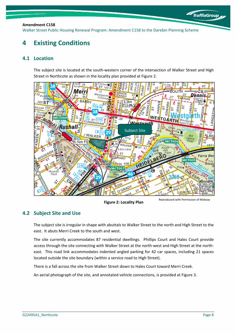
The subject site is located at the south-western corner of the intersection of Walker Street and High Street in Northcote as shown in the locality plan provided at Figure 2.
Figure 2: Locality Plan
4.2 Subject Site and Use
The subject site is irregular in shape with abuttals to Walker Street to the north and High Street to the east. It abuts Merri Creek to the south and west.
The site currently accommodates 87 residential dwellings. Phillips Court and Hales Court provide access through the site connecting with Walker Street at the north-west and High Street at the north-east. This road link accommodates indented angled parking for 42 car spaces, including 21 spaces located outside the site boundary (within a service road to High Street).
There is a fall across the site from Walker Street down to Hales Court toward Merri Creek.
An aerial photograph of the site, and annotated vehicle connections, is provided at Figure 3.
Reproduced with Permission of Melway
Subject Site

Amendment C158 Walker Street Public Housing Renewal Program: Amendment C158 to the Darebin Planning Scheme
G22495A1_Northcote Page 9
Figure 3: Northcote Site Aerial
4.3 Surrounding Land
The subject site is zoned as Neighbourhood Residential Zone – Schedule 1, under the Darebin Planning Scheme.
Significant nearby land uses include:
• Merri Creek and Capital City Trail which run along the southern and western boundaries of the site and provide shared path linkages to areas to the east, south and west of the site.
• Westgarth Neighbourhood Activity Centre approximately 300 metres to the north of the site, which is centred around the commercial and entertainment provisions provided along High Street north of Westgarth Street / Merri Parade;
• Clifton Hill Neighbourhood Activity Centre approximately 600 metres to the south which provides for retail, food and beverage, entertainment and other essential services; and
• Rushall Railway Station which is located less than 300 metres walk from the site boundary via a bridge overpass across Merri Creek accessed from the corner of McLachlan Street and Walker Street west of the site.
Subject Site
Access via Hales Crt
No vehicle connection
Site Access
Amendment C158 Walker Street Public Housing Renewal Program: Amendment C158 to the Darebin Planning Scheme
G22495A1_Northcote Page 10
5 Traffic Considerations
5.1 Road Network
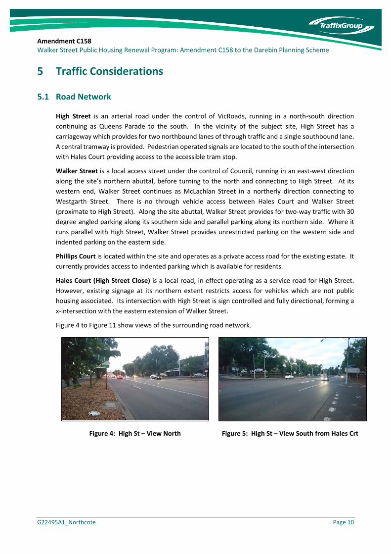
High Street is an arterial road under the control of VicRoads, running in a north-south direction continuing as Queens Parade to the south. In the vicinity of the subject site, High Street has a carriageway which provides for two northbound lanes of through traffic and a single southbound lane. A central tramway is provided. Pedestrian operated signals are located to the south of the intersection with Hales Court providing access to the accessible tram stop.
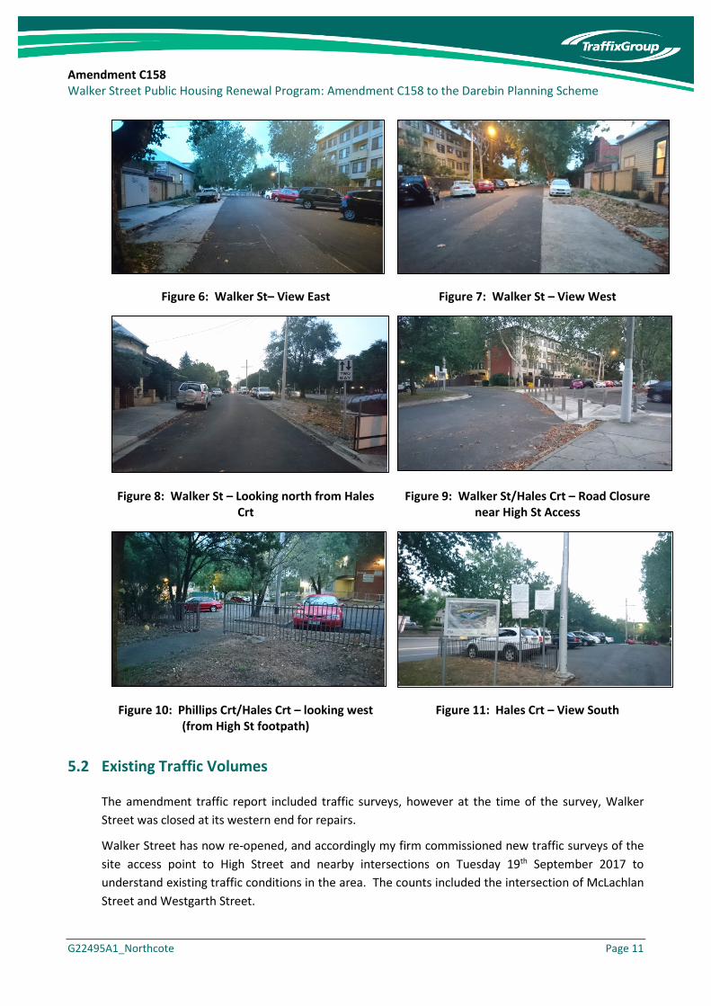
Walker Street is a local access street under the control of Council, running in an east-west direction along the site’s northern abuttal, before turning to the north and connecting to High Street. At its western end, Walker Street continues as McLachlan Street in a northerly direction connecting to Westgarth Street. There is no through vehicle access between Hales Court and Walker Street (proximate to High Street). Along the site abuttal, Walker Street provides for two-way traffic with 30 degree angled parking along its southern side and parallel parking along its northern side. Where it runs parallel with High Street, Walker Street provides unrestricted parking on the western side and indented parking on the eastern side.
Phillips Court is located within the site and operates as a private access road for the existing estate. It currently provides access to indented parking which is available for residents.
Hales Court (High Street Close) is a local road, in effect operating as a service road for High Street. However, existing signage at its northern extent restricts access for vehicles which are not public housing associated. Its intersection with High Street is sign controlled and fully directional, forming a x-intersection with the eastern extension of Walker Street.
Figure 4 to Figure 11 show views of the surrounding road network.
Figure 4: High St – View North Figure 5: High St – View South from Hales Crt
Amendment C158 Walker Street Public Housing Renewal Program: Amendment C158 to the Darebin Planning Scheme
G22495A1_Northcote Page 11
Figure 6: Walker St– View East Figure 7: Walker St – View West
Figure 8: Walker St – Looking north from Hales Crt
Figure 9: Walker St/Hales Crt – Road Closure near High St Access
Figure 10: Phillips Crt/Hales Crt – looking west (from High St footpath)
Figure 11: Hales Crt – View South
5.2 Existing Traffic Volumes
The amendment traffic report included traffic surveys, however at the time of the survey, Walker Street was closed at its western end for repairs.
Walker Street has now re-opened, and accordingly my firm commissioned new traffic surveys of the site access point to High Street and nearby intersections on Tuesday 19th September 2017 to understand existing traffic conditions in the area. The counts included the intersection of McLachlan Street and Westgarth Street.

Amendment C158 Walker Street Public Housing Renewal Program: Amendment C158 to the Darebin Planning Scheme
G22495A1_Northcote Page 12
The peak periods for the network occurred 7:15am-8:15am in the morning period, and 5pm-6pm in the afternoon period, with a summary of peak hour movements illustrated in Figure 12 to Figure 14.
Figure 12: McLachlan Street / Westgarth Street Peak Hour Traffic Volumes
Figure 13: High Street / Walker Street (Cunningham Close) Peak Hour Traffic Volumes

Amendment C158 Walker Street Public Housing Renewal Program: Amendment C158 to the Darebin Planning Scheme
G22495A1_Northcote Page 13
Figure 14: High Street / High Street Close (Site Access) Peak Hour Traffic Volumes
I note that a comparison of the volumes collected at the High Street intersections shows that whilst the PM peak hour period is slightly different (5-6pm as opposed to 4:30pm-5:30pm), the volumes on High Street are relatively comparable between the surveys.
Volumes using the intersection at High Street / High Street Close (the access to DHHS parking) are consistent with those previously recorded.
Observations of traffic conditions reveal that whilst the two-way volume along High Street in the peak hours is in the order of 2,200-2,500 vehicles per hour, gaps are afforded to motorists exiting Walker Street and Hales Court (High Street Close) and the adjacent side streets along High Street.
The pedestrian signals at the site abuttal and the signals to the north of the site (at Merri Parade and Westgarth Street) assist with platooning traffic flows along High Street, particularly during morning and afternoon peak periods when tram users alight at the tram stop and utilise the crossing to cross High Street Road.
Whilst it was observed that motorists exiting the side roads were subject to some delays in the peak hours, motorists were typically able to enter the High Street traffic stream due to queues from the Merri Creek intersection and slow-moving traffic providing courtesy gaps to allow vehicles to enter the road.
5.3 Crash Review
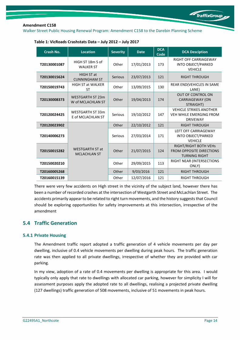
My firm has reviewed the VicRoads Crashstats database for the last five years of available data (July 2012 – July 2017) for the immediate road network, including the intersections of High Street with Walker Street and Cunningham Street, and Westgarth Street and McLachlan Street.
The recorded crashes are summarised within Table 1.
Amendment C158 Walker Street Public Housing Renewal Program: Amendment C158 to the Darebin Planning Scheme
G22495A1_Northcote Page 14
Table 1: VicRoads Crashstats Data – July 2012 – July 2017
Crash No. Location Severity Date DCA Code DCA Desciption
T20130001087 HIGH ST 18m S of WALKER ST Other 17/01/2013 173
RIGHT OFF CARRIAGEWAY INTO OBJECT/PARKED
VEHICLE
T20130015624 HIGH ST at CUNNINGHAM ST Serious 23/07/2013 121 RIGHT THROUGH
T20150019743 HIGH ST at WALKER ST Other 13/09/2015 130 REAR END(VEHICLES IN SAME
LANE)
T20130008373 WESTGARTH ST 23m W of MCLACHLAN ST Other 19/04/2013 174
OUT OF CONTROL ON CARRIAGEWAY (ON
STRAIGHT)
T20120024425 WESTGARTH ST 33m E of MCLACHLAN ST Serious 19/10/2012 147
VEHICLE STRIKES ANOTHER VEH WHILE EMERGING FROM
DRIVEWAY T20120023902
WESTGARTH ST at MCLACHLAN ST
Other 22/10/2012 121 RIGHT THROUGH
T20140006273 Serious 27/03/2014 171 LEFT OFF CARRIAGEWAY
INTO OBJECT/PARKED VEHICLE
T20150015282 Other 21/07/2015 124 RIGHT/RIGHT BOTH VEHs
FROM OPPOSITE DIRECTIONS TURNING RIGHT
T20150020210 Other 29/09/2015 113 RIGHT NEAR (INTERSECTIONS ONLY)
T20160005268 Other 9/03/2016 121 RIGHT THROUGH T20160015139 Other 12/07/2016 121 RIGHT THROUGH
There were very few accidents on High street in the vicinity of the subject land, however there has been a number of recorded crashes at the intersection of Westgarth Street and McLachlan Street. The accidents primarily appear to be related to right turn movements, and the history suggests that Council should be exploring opportunities for safety improvements at this intersection, irrespective of the amendment
5.4 Traffic Generation
5.4.1 Private Housing
The Amendment traffic report adopted a traffic generation of 4 vehicle movements per day per dwelling, inclusive of 0.4 vehicle movements per dwelling during peak hours. The traffic generation rate was then applied to all private dwellings, irrespective of whether they are provided with car parking.
In my view, adoption of a rate of 0.4 movements per dwelling is appropriate for this area. I would typically only apply that rate to dwellings with allocated car parking, however for simplicity I will for assessment purposes apply the adopted rate to all dwellings, realising a projected private dwelling (127 dwellings) traffic generation of 508 movements, inclusive of 51 movements in peak hours.

Amendment C158 Walker Street Public Housing Renewal Program: Amendment C158 to the Darebin Planning Scheme
G22495A1_Northcote Page 15
5.4.2 Public Housing
I have adopted a different approach to the social housing traffic generation previously prepared by my firm. The amendment proposes to replace the existing social housing dwellings (87 dwellings) and provide an additional 8 dwellings. In this regard, it is only the 8 dwellings that will generate additional traffic. For the purposes of this assessment and because the number of additional dwellings is relatively small, I will simply adopt the private dwelling traffic generation rate.
It is therefore expected that the eight (8) additional social housing dwellings will generate a total of 32 movements per day, inclusive of three (3) vehicle movements in peak hours.
5.4.3 Total
The amendment as a whole is projected to generate an additional 540 movements per day, inclusive of 54 movements in peak hours.
Assuming a typical AM peak traffic split of 20% arrivals and 80% departures and PM peak traffic split of 60% arrivals and 40% departures, it is projected the amendment could generate an additional:
o AM PEAK: 11 arrivals and 43 departures
o PM PEAK: 32 arrivals and 22 departures
This level of additional traffic generation is relatively low in traffic engineering terms, equivalent to an average of less than one additional vehicle movement being generated every minute during the peak periods.
5.5 Traffic Distribution
The access arrangements for the site will provide future residents with opportunities to access Walker Street and depart or arrive via Merri Parade (to the north-west) or High Street either via Walker Street or Hales Court (High Street Close).
Based on the existing volumes recorded at each of the surveyed intersections, and the likely location of parking, I have adopted the following splits:
• 40% of vehicles utilise the intersection of McLachlan Street/Westgarth Street.
• 30% of vehicles utilise the intersection of High Street/Cunningham Street/Walker Street.
• 30% of vehicles utilise the intersection of High Street/High Street Close
Once at those intersections, it is likely that vehicles will be split proportionally based on existing turning movements.
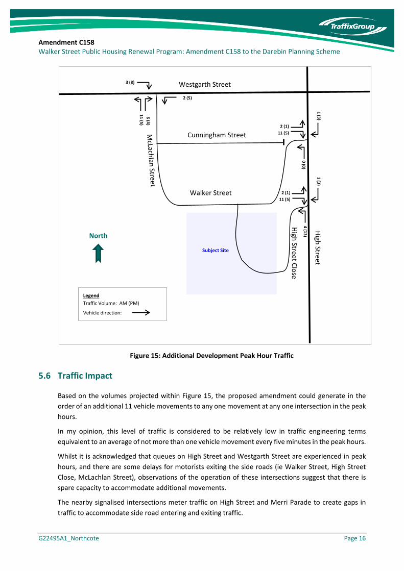
Figure 15 shows the additional traffic movements generated to each intersection and movement in the peak hours.
Amendment C158 Walker Street Public Housing Renewal Program: Amendment C158 to the Darebin Planning Scheme
G22495A1_Northcote Page 16
Figure 15: Additional Development Peak Hour Traffic
5.6 Traffic Impact
Based on the volumes projected within Figure 15, the proposed amendment could generate in the order of an additional 11 vehicle movements to any one movement at any one intersection in the peak hours.
In my opinion, this level of traffic is considered to be relatively low in traffic engineering terms equivalent to an average of not more than one vehicle movement every five minutes in the peak hours.
Whilst it is acknowledged that queues on High Street and Westgarth Street are experienced in peak hours, and there are some delays for motorists exiting the side roads (ie Walker Street, High Street Close, McLachlan Street), observations of the operation of these intersections suggest that there is spare capacity to accommodate additional movements.
The nearby signalised intersections meter traffic on High Street and Merri Parade to create gaps in traffic to accommodate side road entering and exiting traffic.
Legend Traffic Volume: AM (PM) Vehicle direction:
North
Subject Site
High Street
3 (8)
2 (5)
2 (1) 11 (5)
1 (3) 0 (0)
Westgarth Street
Walker Street 2 (1) 11 (5)
1 (3) 4 (13) High Street Close
Cunningham Street

Amendment C158 Walker Street Public Housing Renewal Program: Amendment C158 to the Darebin Planning Scheme
G22495A1_Northcote Page 17
In any event, the number of additional movements presented at any one intersection does not warrant improvements at any of these intersections.
Amendment C158 Walker Street Public Housing Renewal Program: Amendment C158 to the Darebin Planning Scheme
G22495A1_Northcote Page 18
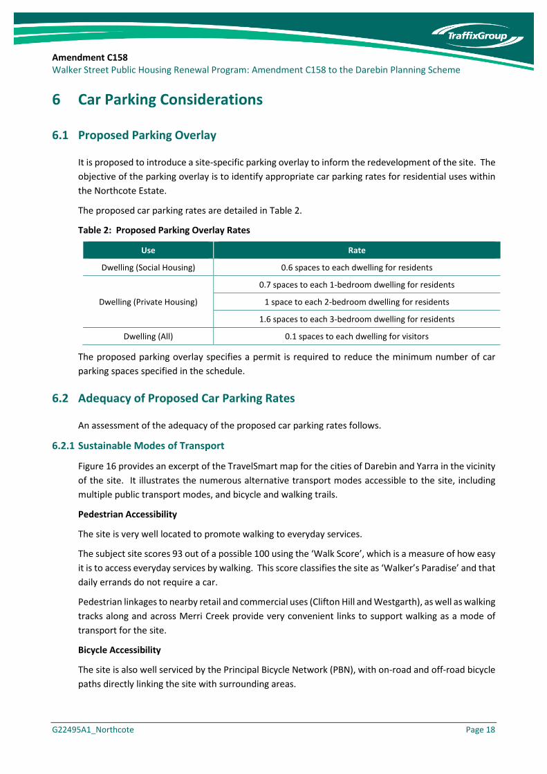
6 Car Parking Considerations
6.1 Proposed Parking Overlay
It is proposed to introduce a site-specific parking overlay to inform the redevelopment of the site. The objective of the parking overlay is to identify appropriate car parking rates for residential uses within the Northcote Estate.
The proposed car parking rates are detailed in Table 2.
Table 2: Proposed Parking Overlay Rates
Use Rate
Dwelling (Social Housing) 0.6 spaces to each dwelling for residents
Dwelling (Private Housing)
0.7 spaces to each 1-bedroom dwelling for residents
1 space to each 2-bedroom dwelling for residents
1.6 spaces to each 3-bedroom dwelling for residents
Dwelling (All) 0.1 spaces to each dwelling for visitors
The proposed parking overlay specifies a permit is required to reduce the minimum number of car parking spaces specified in the schedule.
6.2 Adequacy of Proposed Car Parking Rates
An assessment of the adequacy of the proposed car parking rates follows.
6.2.1 Sustainable Modes of Transport
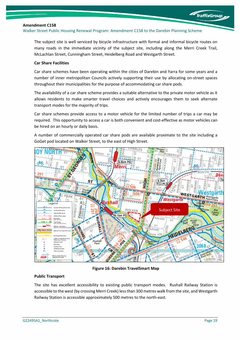
Figure 16 provides an excerpt of the TravelSmart map for the cities of Darebin and Yarra in the vicinity of the site. It illustrates the numerous alternative transport modes accessible to the site, including multiple public transport modes, and bicycle and walking trails.
Pedestrian Accessibility
The site is very well located to promote walking to everyday services.
The subject site scores 93 out of a possible 100 using the ‘Walk Score’, which is a measure of how easy it is to access everyday services by walking. This score classifies the site as ‘Walker’s Paradise’ and that daily errands do not require a car.
Pedestrian linkages to nearby retail and commercial uses (Clifton Hill and Westgarth), as well as walking tracks along and across Merri Creek provide very convenient links to support walking as a mode of transport for the site.
Bicycle Accessibility
The site is also well serviced by the Principal Bicycle Network (PBN), with on-road and off-road bicycle paths directly linking the site with surrounding areas.
Amendment C158 Walker Street Public Housing Renewal Program: Amendment C158 to the Darebin Planning Scheme
G22495A1_Northcote Page 19
The subject site is well serviced by bicycle infrastructure with formal and informal bicycle routes on many roads in the immediate vicinity of the subject site, including along the Merri Creek Trail, McLachlan Street, Cunningham Street, Heidelberg Road and Westgarth Street.
Car Share Facilities
Car share schemes have been operating within the cities of Darebin and Yarra for some years and a number of inner metropolitan Councils actively supporting their use by allocating on-street spaces throughout their municipalities for the purpose of accommodating car share pods.
The availability of a car share scheme provides a suitable alternative to the private motor vehicle as it allows residents to make smarter travel choices and actively encourages them to seek alternate transport modes for the majority of trips.
Car share schemes provide access to a motor vehicle for the limited number of trips a car may be required. This opportunity to access a car is both convenient and cost-effective as motor vehicles can be hired on an hourly or daily basis.
A number of commercially operated car share pods are available proximate to the site including a GoGet pod located on Walker Street, to the east of High Street.
Figure 16: Darebin TravelSmart Map
Public Transport
The site has excellent accessibility to existing public transport modes. Rushall Railway Station is accessible to the west (by crossing Merri Creek) less than 300 metres walk from the site, and Westgarth Railway Station is accessible approximately 500 metres to the north-east.
Subject Site

Amendment C158 Walker Street Public Housing Renewal Program: Amendment C158 to the Darebin Planning Scheme
G22495A1_Northcote Page 20
Tram Route 86 operates along the site’s eastern abuttal and an accessible tram stop is served by pedestrian operated signals adjacent to the site boundary. Bus services are accessible to the site via the Clifton Hill bus/tram interchange to the south.
Table 3 summarises the available services, whilst Figure 17 illustrates the nearby routes.
Table 3: Public Transport Services in the Vicinity of the Subject Site
Service Route Distance to Node
Metropolitan Train Services
Rushall Station City – South Morang ~200m west of the site
Westgarth Station City - Hurstbridge ~400m north-east of the site
Metropolitan Tram Services
Route 86 Bundoora RMIT – Waterfront City Docklands via City ~30m east of the site
Metropolitan Bus Services
250 City (Queen Street) – La Trobe University ~260m south west of the site
251 City (Queen Street) – Northland SC ~260m south west of the site
246 Elsternwick – Clifton Hill via St Kilda ~260m south west of the site
504 Moonee Ponds – Clifton Hill via East Brunswick ~500m south of the site
546 Heidelberg – Melbourne Uni – Queen Victoria Market via Clifton Hill & Carlton ~400m east of the site
Figure 17: PTV Public Transport Map - Darebin
Having regard to the alternative transport modes available to the site, I am of the view that this would support dwellings without car parking.
Subject Site
Amendment C158 Walker Street Public Housing Renewal Program: Amendment C158 to the Darebin Planning Scheme
G22495A1_Northcote Page 21
6.2.2 Anticipated Parking Demand
To understand car ownership data for both social and private housing, I have sourced the 2016 ABS Car Ownership Data for the suburb of Northcote and the municipality of Darebin. The data relates to all apartments / flats / units, whether they be 1 storey or multi-storey.
Public Housing Residents
For Public Housing, the data records an average car ownership of 0.5 cars per flat / apartment for both Northcote and Darebin, with a summary provided in Table 4.
Table 4: 2016 ABS Car Ownership Data – Public Housing Northcote & Darebin
Type Northcote Darebin
Av. rate % ownership Av. rate % ownership
1-bedroom dwellings 0.4 64% w no veh 0.4 60 % w no veh
2-bedroom dwellings 0.6 41% w no veh 0.7 45 % w no veh
3- bedroom dwellings 0.9 40% w 1 veh 0.9 50 % w 1 veh
These statistics indicate that the parking requirements for dwellings set out under the Planning Scheme are greater than the ABS car ownership statistics in this locality.
Public housing demands for 1-bedroom, 2-bedroom and 3-bedroom dwellings are typically less than one vehicle per dwelling, and car parking is not required by a proportion of residents.
Based on the above analysis and in consideration of the excellent accessibility to public transport and services, I am satisfied that it is appropriate to provide new social housing dwellings at a rate of 0.6 spaces per dwelling as proposed within the Parking Overlay.
Private Housing Residents
For private housing, I have used the Northcote and Darebin ABS 2016 car ownership data, and removed the social housing component. A summary of the data is provided in Table 5.
Table 5: 2016 ABS Car Ownership Data – Northcote & Darebin
Type Northcote Darebin
Av. rate % ownership Av. rate % ownership
1-bedroom dwellings 0.8 31% w no veh 0.8 31% w no veh
2-bedroom dwellings 1.1 18% w no veh 1.1 19% w no veh
3- bedroom dwellings 1.7 47 % w 1 veh 1.5 38 % w 1 veh
Based on the above analysis and in consideration of the excellent accessibility to public transport and services, I am satisfied that it is appropriate to provide new private dwellings at a rate of 0.7 spaces per one-bedroom apartment, 1 space per bedroom for two-bedroom apartment, and 1.6 spaces for three-bedroom apartments as proposed within the Parking Overlay.
Amendment C158 Walker Street Public Housing Renewal Program: Amendment C158 to the Darebin Planning Scheme
G22495A1_Northcote Page 22
Residential Visitors
To estimate the projected residential visitor car parking demand, car parking surveys undertaken by Cardno at apartment developments located at 127 and 147 Beach Street in Beacon Cove have been sourced.
The surveys were conducted over a 42 hour period from 6:00am on Friday 19 November to midnight on Saturday 20 November, 2010. The surveys recorded a peak parking demand for 0.1 spaces per apartment of an evening and weekend, with a peak business hours demand of 0.06 spaces per apartment recorded.
Based on these surveys, I am comfortable that a requirement to provide 0.1 spaces per apartment for visitors is appropriate as proposed within the Parking Overlay.
I am of the opinion that on-street parking along the internal street of the site, can be counted as part of the visitor parking provision.
6.2.3 Planning Policy
Council Planning Scheme Policies
Darebin City Council supports sustainable transport and design in new and existing developments through a number of policies and initiatives. Excerpts from some of the relevant Clauses within the Darebin Planning Scheme are provided as follows:
Clause 21.02 Environment
21.02-3 Built Environment
Objective 3 – Environmentally Sustainable Design
To promote and facilitate development that incorporates best practice environmentally sustainable design and promotes sustainable living and business practices.
Strategies
• Encourage the adaptive reuse of buildings to reduce the amount of waste going to landfill.
• Encourage the design of new and retrofitted buildings and public spaces to incorporate high standards of energy efficient design, water sensitive urban design, sustainable transportation, waste reduction and protection of biodiversity.
• Promote the integration of land use and sustainable transport (walking, cycling and public transport) in accordance with the strategies in Clause 21.05-1.
• Encourage best practice industrial and commercial development to minimise amenity impacts and achieve long term environmental sustainability.
• Encourage the preparation of Sustainable Design Assessments and Sustainability Management Plans for residential, mixed use, industrial and commercial developments as part of the planning permit approval process.

Amendment C158 Walker Street Public Housing Renewal Program: Amendment C158 to the Darebin Planning Scheme
G22495A1_Northcote Page 23
Clause 21.05 Transport and Infrastructure
Objective 3 – Car Parking
To manage the provision of car parking and congestion of car parking in Darebin and encourage use of sustainable transport modes to reduce car parking demand.
Strategies
• Consider existing public transport opportunities when assessing applications to waive or reduce car parking.
• Take into consideration existing car parking demand levels when considering applications to waive car parking and ensure there is demonstrated on-street capacity before waiving an on-site car parking requirement, particularly in locations outside of activity centres.
• Consider requiring Travel Plans as a condition of approval for new uses and developments where there is a substantial reduction in car parking from Clause 52.06 requirements.
• Investigate specific parking requirements at a precinct level leading to more localised and area specific provisions.
• Ensure the design of new developments address interfaces with the public realm and support walking, cycling and public transport access, in accordance with the Objectives and Strategies in Clause 21.02-3.
Integrated Transport Strategy
Darebin City Council’s Transport Strategy 2007-27 (Going Places) establishes Council’s strategic direction for transport planning until 2027.
The Darebin Transport Strategy (DTS) aims to promote sustainable transport options and reduce dependence on private car transport. The Plan identifies a range of actions including advocacy, infrastructure development and programs that will be implemented over a twenty-year timeframe. The DTS aims to double the share of walking, cycling and public transport for all trips and for journeys to work by 2027.
Eight key objectives have been developed. They are:
• To improve local and metropolitan accessibility
• To increase the role of sustainable transport modes
• To build new developments that reduce transport demands
• To increase social inclusion for residents
• To improve health and environmental outcomes
• To improve community safety
• To integrate quality urban design, economic development and access
• To engage stakeholders through effective communication
Amendment C158 Walker Street Public Housing Renewal Program: Amendment C158 to the Darebin Planning Scheme
G22495A1_Northcote Page 24
The relevant objectives to this development include:
To increase the role of sustainable transport modes
Cars and trucks are the least energy efficient form of travel (on land) and the greatest contributor to environmental pollution. Therefore, the DTS seeks to promote alternative, more sustainable ways of moving people and good-walking, cycling, public transport and rail-freight.
This is achieved by increasing the attractiveness of those modes through improved services and facilities, priority over other modes, and reducing the attractiveness of the car through reduced priority and other travel demand management techniques.
To build new developments that reduce transport demands
The need to travel and the lengths of journeys can be influenced by the way land is developed. Building housing and key destinations such as jobs, services and shops closer to each other reduces the distances people need to travel, in turn increasing the chance of them utilising more sustainable modes. Concentrating housing closer to public transport increases the chance of residents using it to access more distant destinations.
To integrate quality urban design, economic development and access
Darebin reflects Melbourne’s very car-based society. As a result, the economic prosperity of some of its businesses relies on vehicular access, parking for customers and freight deliveries. However, many people choose to or have no choice but to use other means of travel to access activity centres. In addition, traffic and car parks can adversely affect the pedestrian amenity of activity centres.
Therefore, the DTS seeks to provide good access to its centres and other employment areas by all modes of travel to balance their needs in the design of streets while accommodating freight vehicles.
The site is well located to encourage the use of sustainable transport modes and nearby services and reduced parking provisions would contribute to reducing future resident’s reliance on motor vehicles.
6.3 Proposed Parking Provisions
Based on the preceding, and having particular regard to the proximity of the site to alternative transport modes, 2016 ABS car ownership data, and local council policy, it is considered that the provision of parking at reduced rates from those specified within Clause 52.06 would be appropriate for this site.
I am therefore of the view that the rates outlined within the proposed Schedule to the Parking Overlay are acceptable.

Amendment C158 Walker Street Public Housing Renewal Program: Amendment C158 to the Darebin Planning Scheme
G22495A1_Northcote Page 25
7 Bicycle Considerations
The statutory bicycle parking requirements for future development will be subject to the requirements of Clause 52.34 of the Planning Scheme.
The Scheme requires the provision of 1 bicycle space for each 5 dwellings for residents and 1 space for every 10 dwellings for visitors.
Given that the proposed Parking Overlay proposes reduced car parking rates from Clause 52.06, I am of the opinion that it is appropriate to require additional bicycle parking beyond the requirements of Clause 52.34. Specifically, I recommend that the bicycle requirements for residents be:
1 space for every dwelling without a car space + 1 space for every 5 dwellings with a car space.
The visitor bicycle provision can remain as required by Clause 52.34.
Amendment C158 Walker Street Public Housing Renewal Program: Amendment C158 to the Darebin Planning Scheme
G22495A1_Northcote Page 26
8 Development Plan Requirements
Proposed Schedule 13 to Clause 43.04 Development Plan Overlay sets out the requirements for the provision of a Development Plan for Walker Street, Northcote (the subject land).
With regard to traffic, the Development Plan must seek to:
• Prioritise pedestrian and bicycle access within the site.
The Development Plan must be accompanied by an Integrated Transport and Traffic Management Plan that addresses, but is not limited to, a number of items. Those I consider most relevant include:
• Estimated vehicle trip generation levels resulting from use and development within the site.
• Vehicle ingress and egress points and estimated levels of usage.
• The likely impacts of the proposed development on the arterial and local roads, and any mitigating works required such as off-site traffic management treatments.
• An indicative layout of internal roads that:
o Recognises the primacy of pedestrian and bicycle access within the site.
o Are of sufficient width to accommodate footpaths and street trees.
• The location of on-site parking for residents, visitors and workers (if applicable). The location of parking spaces should be situated at basement level or suitably concealed within buildings.
• Provision of a safe and accessible pedestrian and bicycle network within the site and connecting to the external network.
• Provision for secure bicycle storage for residents and workers (if applicable), end of trip facilities for workers (if applicable) and short term bicycle parking for visitors.
• The views of VicRoads and Darebin City Council.
My evidence addresses the vehicle generation and impacts to the road network for the potential development yield. Nonetheless, at the time of preparation of the Development Plan, these items will be re-addressed within an Integrated Transport and Traffic Management Plan, and the view of VicRoads and Council will be sought.
The Integrated Transport Plan also requires an indicative road layout, which I expect will include a cross section to demonstrate the above principals of providing primacy for pedestrians and cyclists, and have sufficient width to accommodate street trees. Council’s review will be sought on the road network and cross section.
I am of the view that the requirement for the Integrated Transport and Traffic Management Plan will provide appropriate opportunity for the responsible authority to ensure that matters of traffic impacts are considered, and an appropriate internal road network is provided.

Amendment C158 Walker Street Public Housing Renewal Program: Amendment C158 to the Darebin Planning Scheme
G22495A1_Northcote Page 27
9 Conclusions
Having undertaken a detailed traffic engineering assessment of Amendment C158 to the Darebin Planning Scheme, I am of the opinion that:
a) The potential development yield and proposed parking provision could generate an additional 540 movements per day, inclusive of 54 movements in peak hours.
b) The level of potential additional traffic can be accommodated by the proposed site access arrangements, with negligible impacts to the surrounding road network.
c) The resident and visitor parking rates proposed within the Parking Overlay are justified by:
i) The site is located next to an Activity Centre and is well served by public transport and alternative transport modes.
ii) There is a demand for dwellings without resident parking in this locality, as evidenced by the 2016 ABS car ownership data.
iii) Local Policy for City of Darebin supports reduced parking provisions to encourage the use of sustainable transport modes and reduction in traffic congestion caused by private motor vehicle ownership.
d) Bicycle parking should be provided in accordance with Clause 52.34, excepting that the residential tenant provision should include a single bicycle space for each dwelling that is not provided with a car space.
e) There are no traffic engineering reasons that warrant abandonment of Amendment C158 to the Darebin Planning Scheme.
I have made all the inquiries that I believe are desirable and appropriate and there are no matters of significance I regard as relevant, which to the best of my knowledge, have been withheld from the Advisory Committee.
JASON LEE WALSH DIRECTOR TRAFFIX GROUP 22 SEPTEMBER 2017

Amendment C158 Walker Street Public Housing Renewal Program: Amendment C158 to the Darebin Planning Scheme
G22495A1_Northcote
Appendix A Qualifications
Amendment C158 Walker Street Public Housing Renewal Program: Amendment C158 to the Darebin Planning Scheme
G22495A1_Northcote
Name
Jason Lee Walsh - Director, Traffix Group Pty Ltd
Address
Suite 8, 431 Burke Road GLEN IRIS VICTORIA 3146
Qualifications
My educational qualifications and membership of professional associations are as follows:-
• Bachelor of Civil Engineering, Monash University
• Bachelor of Science, Monash University
• Member, Victorian Planning & Environmental Law Association
Experience
I have approximately 20 years experience in Traffic Engineering including,
• 1995-2000 at Turnbull Fenner (now Traffix Group), including short term placements at the cities of Bayside and Whittlesea,
• 2000-2011 at Grogan Richards Pty Ltd (now Cardno),
• 2011-present at Traffix Group.
Areas of Expertise
• Car parking and Traffic.
• Traffic advice and assessment of land uses and development proposals to planning authorities, government agencies, corporations and developers (including major residential, retail, food and drink, commercial, industrial, institutional and mixed use projects).
• Preparation and presentation of evidence before VCAT and Panels.
Expertise to Prepare this Assessment
My experience and expertise over the past 20 years, including involvement with varied forms of developments, qualifies me to comment on the traffic implications of the proposed Amendment.
Instructions
I was instructed by Norton Rose Fulbright on behalf of Department of Health and Human Services to undertake a traffic engineering assessment and prepare an evidence statement for Amendment C158 to the Darebin Planning Scheme.
Amendment C158 Walker Street Public Housing Renewal Program: Amendment C158 to the Darebin Planning Scheme
G22495A1_Northcote
Facts, Matters and Assumptions Relied Upon • Brief provided by Norton Rose Fulbright.
• Exhibited material.
• Design Framework prepared Hayball Architects.
• Site Renewal Traffic and Transport Assessment prepared by Traffix.
• Submissions.
• Darebin Planning Scheme.
• Site inspection.
• Relevant experience.
Documents Taken into Account See above.
Identity of Persons Undertaking Work Jason Walsh as per the evidence statement.
Carlo Morello (Associate, Traffix Group) assisted with preparation of the evidence report.
Summary of Opinions See Conclusions section of the evidence statement.

P####/2016 Walker Street Public Housing Renewal Program: Amendment C158 to the Darebin Planning Scheme
G22495A1_Northcote