waiÿanae and lualualei
TRANSCRIPT

WAIÿANAE AND LUALUALEI
JULY 2010
DEPARTMENT OF HAWAIIAN HOME LANDS
REGIONAL PLAN

Kaulana H. R. Park Chairman
Hawaiian Homes Commission
COMMISSIONERSPerry Artates (Maui)
Donald S. M. Chang (O‘ahu)Stuart Hanchett (Kaua‘i)
Malia Kamaka (West Hawai‘i)Francis K. Lum (O‘ahu)Trish Morikawa (O‘ahu)
Alapaki Nahale-a (East Hawai‘i)Henry K. Tancayo (Moloka‘i)
Anita S. WongDeputy to the Chairman
Robert J. Hall Executive Assistant
DEPARTMENT OF HAWAIIAN HOME LANDSHale Kalaniana‘ole
91-5420 Kapolei Parkway Kapolei, Hawai‘i 96707
www.hawaii.gov/dhhl
Office of the ChairmanTelephone: (808) 620-9500Facsimile: (808) 620-9529
Mailing Address:P.O. Box 1879
Honolulu, Hawai‘i 96805
Planning OfficeTelephone: (808) 620-9480Facsimile: (808) 620-9559
Prepared by: Townscape, Inc.
Contents
II. Homestead and Regional Profile
Regional Demographics
Elected and Appointed OfficialsPolitical Boundaries
III. Regional Land and Development
History and Cultural Aspects of AreaLand and Natural ResourcesHawaiian Home Lands
Map of Development ProjectsDevelopment Projects SummaryDevelopment Characteristics and TrendsOther Lands and Master Plans
IV. Infastructure
WaterDrainageWastewaterRoadsPublic Facilities
V. Homestead Issues and Priorities
Issues, Opportunities, and Potential Projects 262728293031
Priority Project: Kaupuni Community CenterPriority Project: Waiÿanae Kai Community DevelopmentPriority Project: Waiÿanae Transportation Corridor Coordination and ImprovementsPriority Project: Going Greeen in WaiÿanaePriority Project: Agriculture/Aquaculture and Food Security
I. Introduction
Regional Plan Goals Regional Plan ProcessDHHL Partnering Benefits
Community Leaders and Stakeholders
123
4567
101112131415
16-1718-1920-2122-2324-25
89
....................................................................................................................... .................................................................................................................... ..............................................................................................................
................................................................................................................. ............................................................................................ ..................................................................................................... .......................................................................................................................
.............................................................................................. .......................................................................................................... . .................................................................................................................. ................................................................................................................. ........................................................................................................ .................................................................................................... ....................................................................................... .......................................................................................................
............................................................................................................................................ ....................................................................................................................................... ................................................................................................................................... and Transit .......................................................................................................................... .............................................................................................................................
................................................................................. ................................................................................. .............................................................. . ..................... .................................................................................. .........................................................
Future Proposed Project
WAIÿANAE AND LUALUALEI

1
Regional Plan Goals
The mission of the Department of Hawaiian Home Lands (DHHL) is to effectively manage the Hawaiian Home Lands Trust and to develop and deliver lands to native Hawaiians. To accomplish this, DHHL works in partnership with government agencies, private landowners, non-profit organizations, homestead associations, and other community groups. Regional plans provide the means to solidify visions and partnerships that are essential to effectively manage Hawaiian Home Lands trust lands for the betterment of native Hawaiian beneficiaries.
This regional plan is one of twenty (20) regional plans that DHHL is developing statewide. Waiÿanae and Lualualei region is one of the five regions on Oÿahu that have been selected for regional planning. In these regional plans, DHHL takes on a leadership role in the region, working to strengthen the growth of the area, developing partnerships to leverage diverse resources and capital investment; and fostering beneficiary participation in determining the future direction of the homestead community. The regional plans provide the Department and the affected homestead community opportunities to assess land use development factors, identify issues and opportunities, and identify the region’s top priority projects slated for implementation within the next three (3) years.
What are Regional Plans?
Regional Plans are part of DHHL’s 3-tiered Planning System (see Figure 1). At tier one is the General Plan which articulates long-range Goals and Objectives for the Department. At the second tier, there are Program Plans that are statewide in focus, covering specific topic areas such as the Native Hawaiian Housing Plan and a Native Hawaiian Development Program Plan. Also at this second tier are the Department’s Island Plans that identify the Department’s Land Use Designations per island which function similar to the counties’ land use zones. The regional plans are located at the third tier in the Department’s planning system which focuses at the community/regional level. The regional plans apply the goals, policies, and land use designationsto specific geographic regions.
The regional plans are a means to:• Identify data - people, lands, and infrastructure of homestead communities and the surrounding region;• Identify what DHHL and other landowners are planning to do;• Provide the primary mechanism for beneficiary input in the development of their homestead communities;• Identify issues and potential projects; and • Identify Priority Projects determined by the Department and homestead community.
-
3rd Tier
2nd Tier
1st Tier
Figure 1. DHHL’s Planning System
Statewide, 20 year timeframeGeneral Plan
Strategic Program Plans Island Plans
Regional PlansHomestead Areas, 1-3 year timeframe
Statewide, 3-6 year timeframe Geographic, 10 year timeframe
WAIÿANAE AND LUALUALEI

2
I. Introduction - Regional Plan Process
How are Regional Plan Developed?The regional plans are developed in conjunction with lessees of the region as well as regional stakeholders (landowners, agencies, other organizations) in a series of planning meetings as illustrated in Figure 2. During these meetings, issues and opportunities that should be addressed in the regional plan are identified and a list of potential projects is developed to address those issues and opportunities. From this list lessees determine by consensus, their top five (5) priority projects that are written up with project details, budget estimates, and other pertinent project planning information. Draft regional plans are then subject to the approval of the Hawaiian Homes Commission, which means that the Commission and Department officially support the priorities identified in the regional plan.
Upon approval, the homestead community, the Department, and other development partners can seek necessary funding and pursue the implementation of the Priority Projects. The Priority Projects are a key component of aligning support and providing focus to efforts to develop the region. Finally, since DHHL knows that regional development is a dynamic process with constantly changing opportunities and emerging issues, regular regional plan updates are built into the planning process. In this way, regional plans are updated as needed, which generally have amounted to biennial updates (one update every two years), in order to keep abreast of changing conditionsand new opportunities.
How are Regional Plan Used?As a compilation of existing plans and proposed projects for the region, the regional plan helps to coordinate the orderly development of regional infrastructure improvements. With the addition of lessee input in the process, the regional plans become a powerful tool to focus energies and efforts, align interests, and secure funding for the top priorities identified in the regional plan. In this way, regional plans have become a critical tool to unify and support our beneficiary community.
Gather Data
Conduct Planning Meetings
Identify Potential Projects
Identify Priority Projects
Biennial Updates
HHC Approval
Implement Projects
Figure 2. The Regional Plan Development and Update Process
• Interview Agencies • Interview Landowners • Demographic Data • Development Trends • Legislation • Funding
• Homestead Leaders • Beneficiaries/Lessees • Surrounding Landowners • Government Agencies • Community Organizations
Beneficiary Community
WAIÿANAE AND LUALUALEI

3
DHHL Partnering Benefits DHHL is working in partnership with other government agencies, the private sector, and communityorganizations to develop its lands and improve community life. DHHL believes that partnerships are an effective way to leverage resources and capital investments, mitigate undesirable impacts of development, coordinate area growth, reduce risks in large scale community projects, and create broad community benefits.
These partnerships allow for better prioritization and coordination of infrastructure improvement and the development of regional public and residential facilities. This coordination helps individual organizations achieve their goals while bringing long-term benefits to the community and region.
DHHL brings to these partnerships:• Land for development in strategic locations• Potential use of tax-exempt financing• Access to legislative appropriations• Access to federal funding such as HUD, USDA, SBA• Flexibility in the application of development standards, zoning, and design• Cultural understanding and resources
DHHL has participated in a number of successful partnerships. A few of these are highlighted here.
1. Residential PartnershipsThrough partnerships DHHL has reduced the cost of homes to low-income beneficiaries. DHHL has done this by sharing in the cost of infrastructure, helping to secure tax credits, and using self-help methods of construction. Partnerships in Kapolei resulted in 70 Rent-to-Own units constructed by Mark Development using low-income tax credits and 45 self-help homes constructed with Menehune Development and Honolulu Habitat for Humanity. A partnership with Kauai Habitat for Humanity resulted in 20 homes in Hanapepe and a partnership with Kokua Housing resulted in 41 self-help homes at Laiopua in Kona. In these types of partnerships, DHHL provides the land, secures federal grants, and provides access to, or assistance in, acquiring tax credits, subsidies, or other financing.
2. Infrastructure PartnershipsDHHL has partnered with county governments and utility providers on infrastructure improvements that benefit the entire community. DHHL has participated in water system development with the counties by providing funding, land easements, and access to federal and state programs. Examples include the extension of the Lower Kula Water System on Maui, the Waimea Irrigation System and the Makuÿu Water System on Hawaii, and the Waiawa-Waipahu water system on Oahu. DHHL water systems at Anahola on Kauaÿi, and Ho‘olehua on Molokaÿi are interconnected with nearby County water systems providing both parties backup source and storage capacity in the event of emergencies. DHHL has also provided numerous easements over its lands to electrical, water, telephone, and cable companies to service both homestead areas and the general public.
3. Public Facilities PartnershipsDHHL has participated in a number of partnerships involving public facilities and community resources. The most notable partnerships have brought together Hawaiian agencies and non-profit organizations into a multi-service complex where a broad range of programs are housed to serve the public. Such multi-service complexes have been built on Hawaiian Home Lands in partnership with Kamehameha Schools, Queen Liliÿuokalani Children’s Center, Alu Like, Papa Ola Lökahi, the Office of Hawaiian Affairs, Hawaiian community organizations, and the counties. These multi-service complexes are housing preschools, offices, meeting facilities, health clinics, and activity centers. For example, the Paukükalo homestead on Maui isserved by a County park on DHHL land next to a community hall, the DHHL district office, the Hawaiian Community Assets’ homeownership counseling center, and a Kamehameha preschool. The Keaukaha homestead on Hawaiÿi is served by a County park and gymnasium next to an elementary school, DHHL and OHA offices, and a Kamehameha preschool. DHHL, private businesses, government agencies, and private foundations have joined together to provide materials for playgrounds constructed by homestead associations and other community volunteers.
Through a series of management partnerships with DLNR and the Nature Conservancy, unique ecosystems and historic sites are being protected. Examples include the Hakalau Forest Reserve, the ‘Aina Hou Management Area, the Päläÿau and Moÿomomi preserves, the Kalaupapa peninsula, and the Kamaaoa-Puÿueo National Historic District where koa forests, endangered plants and animals, and native species are being protected for future generations. Beachfront recreational values are protected through management agreements with the City and County of Honolulu for Makapuÿu, Kaiona, Kaupö, Waimänalo, and Nänäkuli beach parks. A three-mile stretch of ocean front Hawaiian home lands property at Anahola on Kauaÿi is maintained as open space and made part of the County’s walking/biking system, which will eventually stretch from Lïhuÿe to Moloaÿa.
Self-Help Housing in Kapolei
Community Center in Waimänalo
Ka Waihona o ka Na‘auao Charter School, Located on the Former Nänäikapono Elementary School Site in Nänäkuli
WAIÿANAE AND LUALUALEI
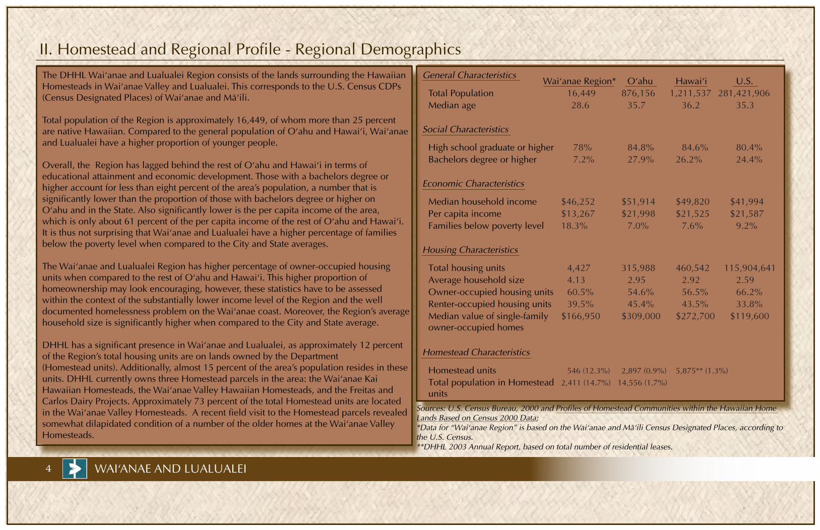
II. Homestead and Regional Profile - Regional Demographics
16,449 876,156 1,211,537 281,421,90628.6 35.7 36.2 35.3
78% 84.8% 84.6% 80.4%7.2% 27.9% 26.2% 24.4%
$46,252 $51,914 $49,820 $41,994$13,267 $21,998 $21,525 $21,58718.3% 7.0% 7.6% 9.2%
4,427 315,988 460,542 115,904,6414.13 2.95 2.92 2.5960.5% 54.6% 56.5% 66.2%39.5% 45.4% 43.5% 33.8%
$166,950 $309,000 $272,700 $119,600
546 (12.3%) 2,897 (0.9%) 5,875** (1.3%)
2,411 (14.7%) 14,556 (1.7%)
4 WAI‘ANAE AND LUALUALEI
Sources: U.S. Census Bureau, 2000 and Profiles of Homestead Communities within the Hawaiian Home Lands Based on Census 2000 Data;*Data for “Waiÿanae Region” is based on the Waiÿanae and Mäÿili Census Designated Places, according to the U.S. Census. **DHHL 2003 Annual Report, based on total number of residential leases.
Median household incomePer capita income
Homestead units
Families below poverty level
Total housing units Average household sizeOwner-occupied housing units Renter-occupied housing units Median value of single-familyowner-occupied homes
General Characteristics
Median ageTotal Population
Bachelors degree or higherHigh school graduate or higher
Economic Characteristics
Social Characteristics
Housing Characteristics
Homestead Characteristics
Total population in Homestead units
U.S.HawaiÿiOÿahuWaiÿanae Region*The DHHL Waiÿanae and Lualualei Region consists of the lands surrounding the Hawaiian Homesteads in Waiÿanae Valley and Lualualei. This corresponds to the U.S. Census CDPs (Census Designated Places) of Waiÿanae and Mäÿili.
Total population of the Region is approximately 16,449, of whom more than 25 percent are native Hawaiian. Compared to the general population of Oÿahu and Hawaiÿi, Waiÿanae and Lualualei have a higher proportion of younger people.
Overall, the Region has lagged behind the rest of Oÿahu and Hawaiÿi in terms of educational attainment and economic development. Those with a bachelors degree or higher account for less than eight percent of the area’s population, a number that is significantly lower than the proportion of those with bachelors degree or higher on Oÿahu and in the State. Also significantly lower is the per capita income of the area, which is only about 61 percent of the per capita income of the rest of Oÿahu and Hawaiÿi. It is thus not surprising that Waiÿanae and Lualualei have a higher percentage of families below the poverty level when compared to the City and State averages.
The Waiÿanae and Lualualei Region has higher percentage of owner-occupied housing units when compared to the rest of Oÿahu and Hawaiÿi. This higher proportion ofhomeownership may look encouraging, however, these statistics have to be assessed within the context of the substantially lower income level of the Region and the well documented homelessness problem on the Waiÿanae coast. Moreover, the Region’s average household size is significantly higher when compared to the City and State average.
DHHL has a significant presence in Waiÿanae and Lualualei, as approximately 12 percent of the Region’s total housing units are on lands owned by the Department (Homestead units). Additionally, almost 15 percent of the area’s population resides in these units. DHHL currently owns three Homestead parcels in the area: the Waiÿanae Kai Hawaiian Homesteads, the Waiÿanae Valley Hawaiian Homesteads, and the Freitas and Carlos Dairy Projects. Approximately 73 percent of the total Homestead units are located in the Waiÿanae Valley Homesteads. A recent field visit to the Homestead parcels revealed somewhat dilapidated condition of a number of the older homes at the Waiÿanae Valley Homesteads.
Community Leaders and Stakeholders
Disclaimer: The information and recommendations expressed in this report are not necessarily endorsed by the people depicted on this page. These same people cannot be held liable for the information presented or the results of the report.
Wai‘anae Coast Neighborhood Board #24
Jo JordanChair
Wai‘anae HarborWilliam Aila
Harbor Master
Wai‘anae Coast Community Alternative Development Corporation (WCCADC)
Puanani Burgess
Ka‘ala FarmEric Enos
Program Director
Thomas Zizzi
Dee Jay A. Mailer
Law Office of Thomas C. Zizzi
Wai‘anae Valley Homestead Community Association
Lokana Keliÿikoa PuaPresident
Wai‘anae Kai Homestead Community Association
Herbert Hew LenPresident
Wai‘anae Coast Neighborhood Board
Subdistrict 1 Representative
Subdistrict 1 Representative
Johnnie-Mae L. Perry
Subdistrict 2 Representative
Michael Anderson
At Large
Albert H. Silva
Bob Smith
Fred Saunders
Mälama Mäkua
Fred Dodge
Hawai‘i Coalition of Christian Churches
Pastor Wade “Boo” Soares
Leeward Community College, Chancellor
Wai‘anae and Nänäkuli Boys & Girls Club, Director Puamamo Wa‘a
Wai‘anae Coast Comprehensive Health Center, Executive Director
Richard Bettini
Community Planners
Ho‘oipo Decambra
Billie Hauge
Consuelo Foundation, CEO
Geri Marullo
Queen Lili‘uokalani Trust, Waiÿanae Unit Manager
---------------------------------------------------------------------------------------------------------------------------------
The organizations listed below have also been recognized by the Wai‘anae community as important leaders and stakeholders:
ÿÖpelu Fishermen
Kaiser Permanente
Wai‘anae Civic Club Tamura’s Supermarket
Manny Cabral
Nänäkuli - Wai‘anae Schools Complex, Superintendent Lisa DeLong
MA‘O Farm (youth training program) Kamuela Enos & Kukui Maunakea-Forth
Hawaiian Community Development, CEO Kali Watson
At Large
At Large
Suzanne E. Leonida
Subdistrict 2 Representative
Subdistrict 2 Representative Frank D. Slocum
Calvin Endo
5WAI‘ANAE AND LUALUALEI
Kamehameha Schools, CEO
Wai‘anae Kai Homestead Community Association
Beatrice Hew Len
Leilani Collins
Mäkaha Elementary School, Principal
Mäÿili Elementary School, Principal
Leihoku Elementary School, Principal
Waiÿanae Elementary School, Principal John Wataoka
Disa Hauge
Waiÿanae Intermediary School, Principal
Waiÿanae High School, Principal
Kamaile Academy
Adventist Mälama Elementary
Mä‘ili Bible School Habitat for Humanity
Randall Miura
Raechelle Fabrao
Nelson Shigeta
Lynn Okamura

6
II. Homestead and Regional Profile - Elected and Appointed Officials
Maile S. L. ShimabukuroState House of Representatives
District 45
Mufi HannemanHonolulu Mayor
Todd K. ApoCity Council Member
District 1
Colleen HanabusaState Senatorial
District 21
Linda LingleGovernor
Duke AionaLt. Governor
Daniel K. InouyeU.S. Senator
Mazie HironoU.S. Representative
Congressional District 2
Daniel K. AkakaU.S. Senator
Kaulana H.R. ParkHawaiian Homes Commission
Chairman
Trish MorikawaHawaiian Homes Commission
O‘ahu Commissioner
Francis K. LumHawaiian Homes Commission
O‘ahu Commissioner
Haunani ApolionaOHA Chairperson
Donald S. M. ChangHawaiian Homes Commission
O‘ahu Commissioner
Disclaimer: The information and recommendations expressed in this report are not necessarily endorsed by the people depicted on this page. These same people cannot be held liable for the information presented or the results of the report.
Walter M. HeenOHA Trustee, O‘ahu Chair
WAIÿANAE AND LUALUALEI

7
Political Boundaries
City
Cou
ncil
Dis
tric
t 1
Stat
e H
ouse
of R
epre
sent
ativ
es D
istr
ict 4
5
Stat
e Se
nato
rial
Dis
tric
t 21
Nei
ghbo
rhoo
d Bo
ard
24
WAI‘ANAE AND LUALUALEI
Kaena Point
Mäÿili Point
Kaena Point
Mäÿili Point
Kaena Point
Mäÿili Point
Kaena Point
Mäÿili Point
8 WAI‘ANAE AND LUALUALEI
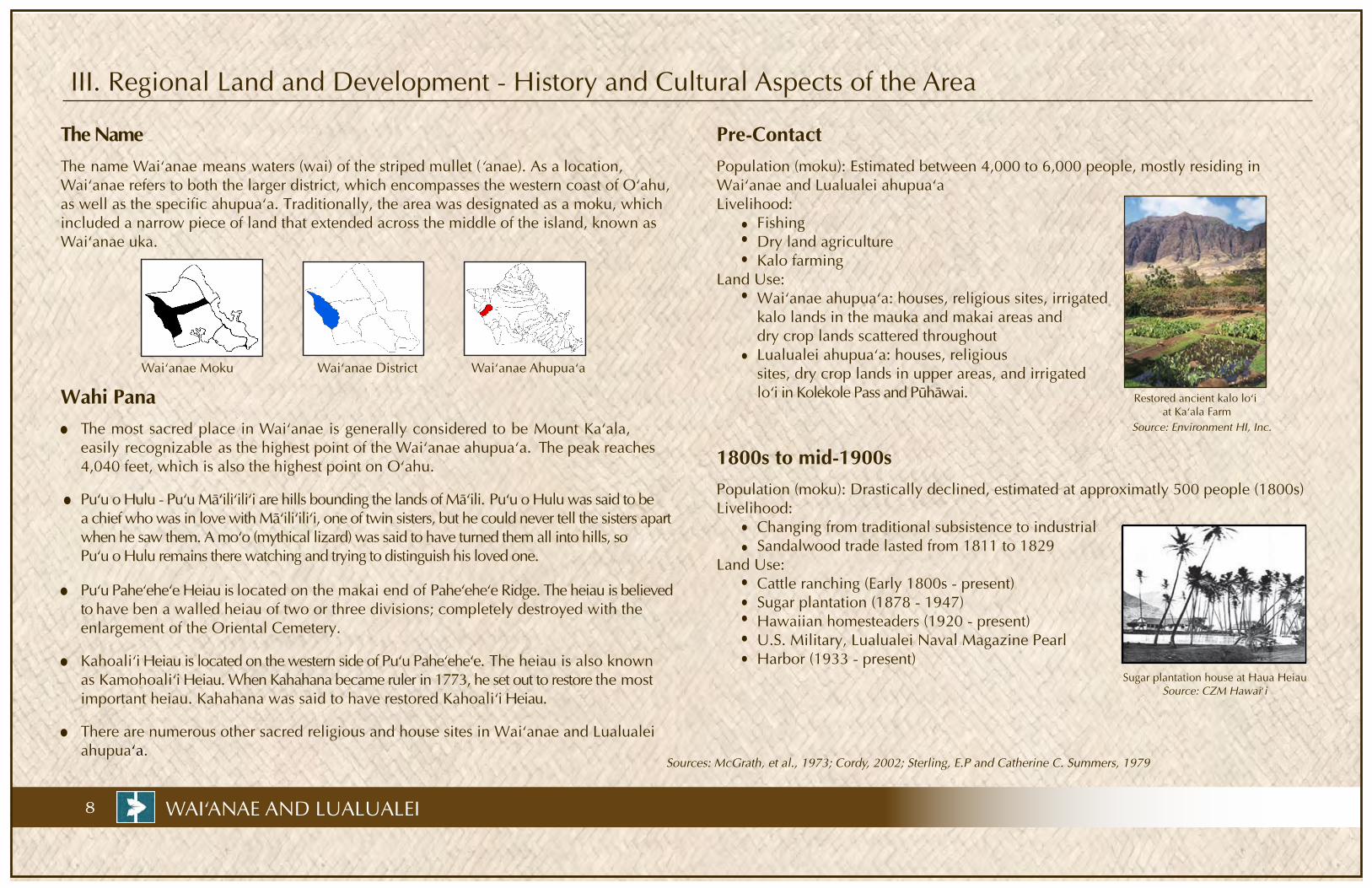
III. Regional Land and Development - History and Cultural Aspects of the Area
The NameThe name Wai‘anae means waters (wai) of the striped mullet (‘anae). As a location, Wai‘anae refers to both the larger district, which encompasses the western coast of O‘ahu,as well as the specific ahupua‘a. Traditionally, the area was designated as a moku, which included a narrow piece of land that extended across the middle of the island, known as Wai‘anae uka.
Wai‘anae Moku
Wai‘anae District
Wai‘anae Ahupua‘a
Wahi PanaThe most sacred place in Wai‘anae is generally considered to be Mount Ka‘ala, easily recognizable as the highest point of the Wai‘anae ahupua‘a. The peak reaches 4,040 feet, which is also the highest point on O‘ahu.
1800s to mid-1900s
Restored ancient kalo lo‘i at Ka‘ala Farm
Source: Environment HI, Inc.
Population (moku): Estimated between 4,000 to 6,000 people, mostly residing in Waiÿanae and Lualualei ahupua‘aLivelihood: Fishing Dry land agriculture Kalo farming Land Use: Waiÿanae ahupuaÿa: houses, religious sites, irrigated kalo lands in the mauka and makai areas and dry crop lands scattered throughout Lualualei ahupua‘a: houses, religious sites, dry crop lands in upper areas, and irrigated loÿi in Kolekole Pass and Pühäwai.
Pre-Contact
Population (moku): Drastically declined, estimated at approximatly 500 people (1800s)Livelihood: Changing from traditional subsistence to industrial Sandalwood trade lasted from 1811 to 1829Land Use: Cattle ranching (Early 1800s - present) Sugar plantation (1878 - 1947) Hawaiian homesteaders (1920 - present) U.S. Military, Lualualei Naval Magazine Pearl Harbor (1933 - present) Sugar plantation house at Haua Heiau
Source: CZM Hawai‘i
There are numerous other sacred religious and house sites in Waiÿanae and Lualualeiahupuaÿa.
Puÿu o Hulu - Puÿu Mäÿiliÿiliÿi are hills bounding the lands of Mäÿili. Puÿu o Hulu was said to be a chief who was in love with Mäÿiliÿiliÿi, one of twin sisters, but he could never tell the sisters apart when he saw them. A moÿo (mythical lizard) was said to have turned them all into hills, so Puÿu o Hulu remains there watching and trying to distinguish his loved one. Puÿu Paheÿeheÿe Heiau is located on the makai end of Paheÿeheÿe Ridge. The heiau is believed to have ben a walled heiau of two or three divisions; completely destroyed with the enlargement of the Oriental Cemetery. Kahoaliÿi Heiau is located on the western side of Puÿu Paheÿeheÿe. The heiau is also known as Kamohoaliÿi Heiau. When Kahahana became ruler in 1773, he set out to restore the most important heiau. Kahahana was said to have restored Kahoaliÿi Heiau.
Sources: McGrath, et al., 1973; Cordy, 2002; Sterling, E.P and Catherine C. Summers, 1979

9
Waiÿanae and Lualualei Land and Natural Resources
Land Forms and Topography
Geology
Soils
Vegetation
Critical Habitat
Climate
Water Resources
WAIÿANAE AND LUALUALEI
In Waiÿanae and Lualualei, rainfall gradually increases from 20 inches per year near the shore to 60 and 40 inches per year in the upper valley areas.
The Waiÿanae and Lualualei region has a generally arid climate The coastal area of the region receives 20 inches of rainfall per year
Waiÿanae and Lualualei region is part of the Waiÿanae Mountains, which was once a large shield volcano that formed a gently sloping dome. Overtime, the massive volcano began to erode from rain, wind, and wave actions resulting in wide and gentlysloping valleys with dramatic hills dotting low lying areas, thus forming the dramatic features of Waiÿanae today.
Pre-contact vegetation cover: The Waiÿanae District was dominated by lowland dry forest and lowland dry shrubland and grassland. The lowland dry forest encompassed approximately 50 percent of the land area, primarily in the valleys. The lowland dry shrubland and grassland covered up to 20 percent of the land area and can be found primarily on the coastal plains.
Non-native vegetation communities cover up to 96 per-cent of the landscape. Native communities can only be found on those lands that are generally inaccessible due to private ownership or rough, steep terrain. Lowland dry forests currently account for only about 0.06 percent of the vegetation and lowland dry shrubland and grassland account for only 0.14 percent of the vegetation.
Modern vegetation:
A critical habitat is an area determined to have essential resources for the continued viability of threatened or endangered species. Several parts of the upper Waiÿanaeand Lualualei Valleys have been designated as critical habitats for ÿelepaio birds and some native plants. Additionally, some wetlands in Lualualei Valley have been designated as waterbird critical habitats.
Coastal areas: coral outcrops and soils with thin topsoil over coral or sandLower to mid-level elevation: scattered good agricultural soils especially along the main stream channelsUpper ridges: steep, stony and rocky mountain lands
Sources: Soil Survey for the Islands of Kauaÿi, Oÿahu, Maui, Molokai, and Lanai, State of Hawaiÿi, 1972; Volcanoes in the Sea: the Geology of Hawaiÿi, Mcdonald, et al., 1983;http://www.state.hi.us/dbedt/gis/data
Two streams are found in the Waiÿanae and Lualualei region: Kaupuni Stream and Mäÿiliÿiliÿi Stream. Both streams are “intermittent” or flowing only after significant rainfalls. Both Waiÿanae and Lualualei have limited ground water resources. Federal and private water systems can be found in Lualualei. Approximately a quarter of all BWS water produced for the Waiÿanae District comes from sources within the Waiÿanae ahupuaÿa.
The nearshore waters of Waiÿanae and Lualualei are heavily utilized by residents and visitors. Nearshore water quality has been threatened by both current uses and historical military weapons disposal in the coastal area.
Kaÿala BogHighest point inWaiÿanae Ridgeat 4040 ft
Paheÿeheÿe Ridge
Puÿu Kamaileÿunu
Puÿu Mäÿiliÿiliÿi
Puÿu Keaÿau
Wide and gently sloping
valley floor in Lualualei
Relatively steep
valley floor in upper Waiÿanae
Sandy shorelines Coastal plains
MäkahaValley

III. Regional Land and Development - Hawaiian Home Lands in Wai‘anae and Lualualei Ahupua‘a
TOTAL: • 546 existing single-family residences
• Approximate population of 2,410
Former Voice of America Site
89 acres on TMK 8-7-10:7; currently vacant
Title is held by the Federal GSA, pending transfer to DHHL
Proposed Lands for DHHL Homestead Development in Partnership with Kamehameha Schools in the Ka Pua Mäkaha Project• 234 acres on TMKs 8-4-02:05, 56, 57; currently used as golf course
•
•
•
DHHL PARCELS
Wai‘anae Kai Hawaiian Homesteads
150 single-family residences on 22 acres; approximate population of 650
Wai‘anae Valley Hawaiian Homesteads
•
•
Freitas & Carlos Dairy Projects
• Planned 32 single-family residences and 21 agricultural lots on 93 acres
Ka‘ala Farm
Pähe‘ehe‘e Ridge
• Planned 19 farm lots on 234 acres, site work completed
•
19.8 acres land on TMKs 8-6-01: 25, 26, 27, 28
Currently leased to Wai‘anae Coast Comprehensive Health Center for their facilities
Wai‘anae Coast Comprehensive Health Center Site-2
Wai‘anae Coast Comprehensive Health Center and Former City Baseyard Site
•
Kaupuni Village
• Planned 18 house lots and a community center on a 3.353 acres
Lot construction is completed, first house is expected to be completed in 3rd quarter of 2010
•
•
396 single-family residences on 98 acres; approximate population of 1,760
A
I
C
G
J
D
F
H
E
B
Native Hawaiian Cultural Center on 97 acres; TMK 8-5-05:36
No houses built because area needs drainage plan and rock fall mitigation
7.4 acres on TMKs 8-6-01:22, 40, 41, 46, & 57
•
10 WAI‘ANAE AND LUALUALEI
K Lualualei Lands
•
•
74.533 acres on TMKs 8-6-03:1-3, 51-52, and 8-6-14:1
Mostly in agricultural use¯
0.5 210
Miles
BJ
I
H
F
E
D
C
A
G
K
Future Kamehameha SchoolsLearning Center. Part of the DHHL and KS“Ka Pua” Mäkaha project
11WAI‘ANAE AND LUALUALEI
Future Proposed Project
Reserved for information on the proposed DHHL and Kamehameha Schools “Ka Pua” Mäkaha
Project, pending beneficiary consultation and Hawaiian Homes Commission approval
12 WAI‘ANAE AND LUALUALEI
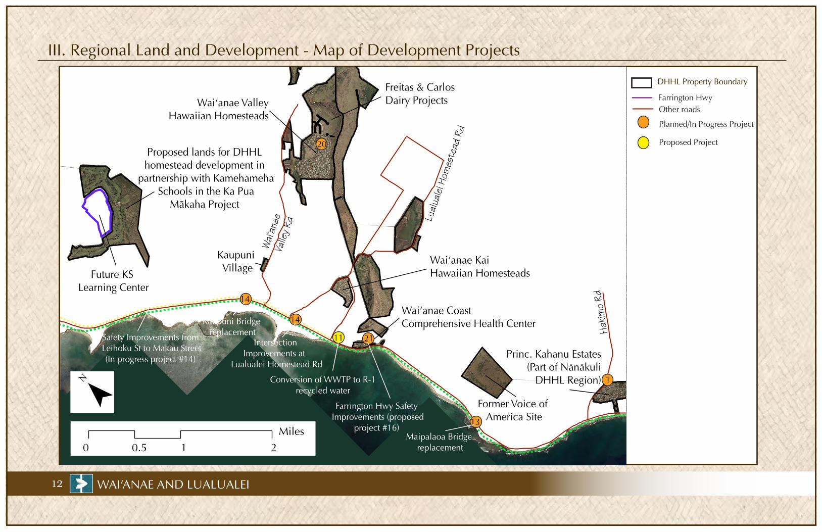
III. Regional Land and Development - Map of Development Projects
DHHL Property Boundary
Farrington Hwy
Proposed Project
Planned/In Progress Project
Other roads
¯0.5 210
Miles
Hakim
o Rd
Lual
ualei
Hom
este
ad R
d
Waiÿa
nae
Valle
y Rd
Proposed lands for DHHL homestead development in
partnership with Kamehameha Schools in the Ka Pua
Mäkaha Project
Waiÿanae ValleyHawaiian Homesteads
Freitas & CarlosDairy Projects
Future KS Learning Center
Waiÿanae KaiHawaiian Homesteads
Waiÿanae Coast Comprehensive Health Center
Kaupuni Village
Former Voice of America Site
Princ. Kahanu Estates (Part of Nänäkuli
DHHL Region)
21
13
14
1
11
14
20
Safety Improvements from Leihoku St to Makau Street(In progress project #14)
Farrington Hwy Safety Improvements (proposed
project #16)
Conversion of WWTP to R-1 recycled water
Maipalaoa Bridge replacement
Kaupuni Bridge replacement
Intersection Improvements at
Lualualei Homestead Rd
13
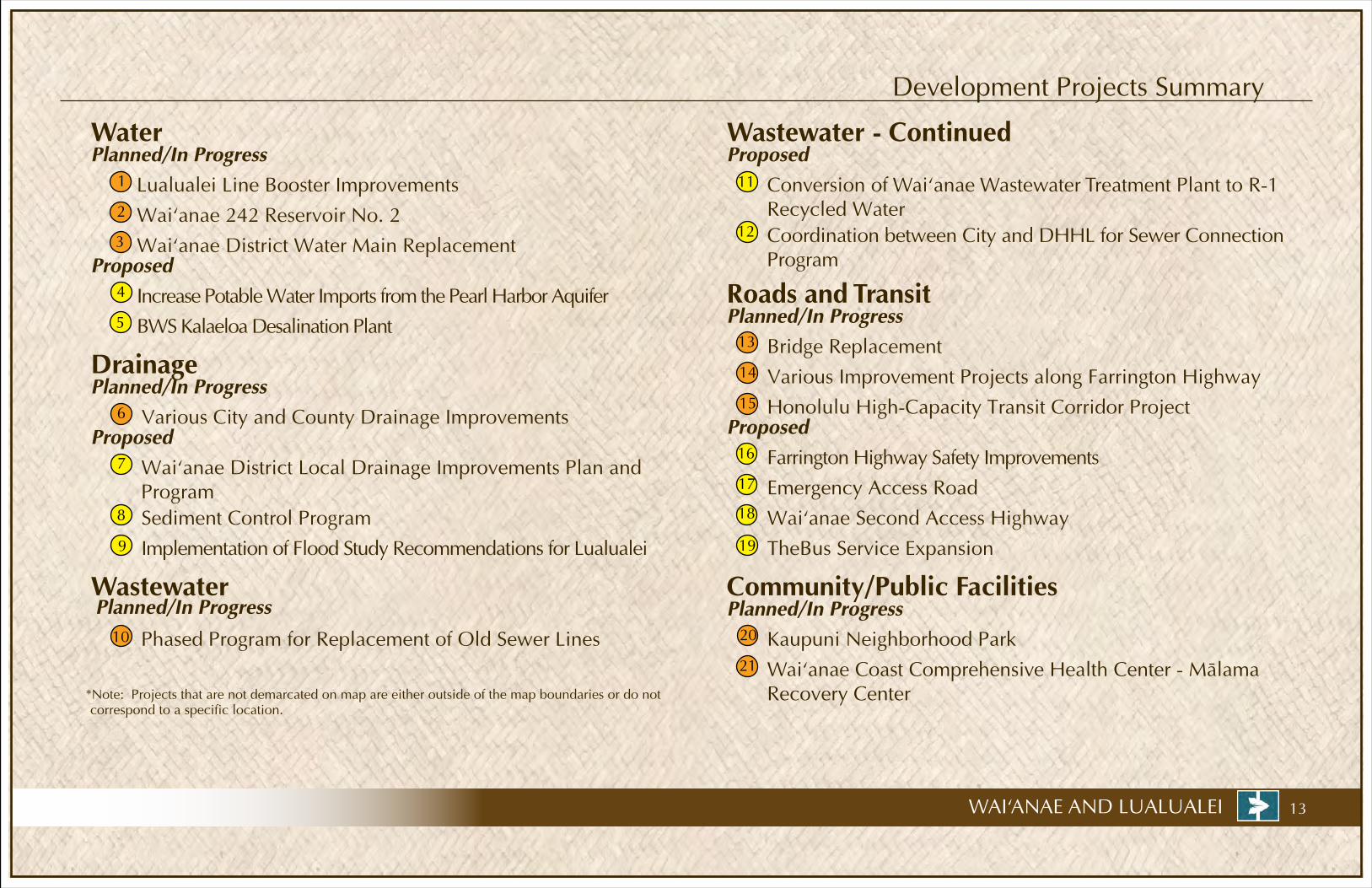
Wastewater - ContinuedProposed
Conversion of Wai‘anae Wastewater Treatment Plant to R-1Recycled Water
Phased Program for Replacement of Old Sewer Lines
Community/Public Facilities
Development Projects Summary
Roads and TransitProposed
Waiÿanae District Water Main Replacement
Planned/In Progress
Increase Potable Water Imports from the Pearl Harbor Aquifer
Water
ProposedWaiÿanae District Local Drainage Improvements Plan and Program
Planned/In Progress
Implementation of Flood Study Recommendations for Lualualei
Various City and County Drainage Improvements
Sediment Control Program
*Note: Projects that are not demarcated on map are either outside of the map boundaries or do not correspond to a specific location.
Waiÿanae 242 Reservoir No. 2
BWS Kalaeloa Desalination Plant5
4
2
Lualualei Line Booster Improvements
19 9
8
6
10
7
Coordination between City and DHHL for Sewer Connection Program
12
11
Planned/In Progress
Wai‘anae Coast Comprehensive Health Center - Mälama Recovery Center
14
21
Kaupuni Neighborhood Park 20
15
3
1
Drainage
Proposed
Planned/In Progress
Waiÿanae Second Access Highway
Emergency Access Road
Farrington Highway Safety Improvements
Bridge Replacement
17
13
16
Honolulu High-Capacity Transit Corridor Project
Various Improvement Projects along Farrington Highway
TheBus Service Expansion
WAI‘ANAE AND LUALUALEI
WastewaterPlanned/In Progress
18

III. Regional Land and Development - Development Characteristics and Trends
0 11 9
148 150
0
99
00
50
100
150
1999
-2000
1995
-1998
1990
-1994
1980
-1989
1970
-1979
1960
-1969
1940
-1959
1939
-earlie
r
Employed Civilians by Industry in 2000(Wai‘anae CDP + Mä‘ili CDP)
Source: Wai‘anae Sustainable Communities Plan, 2009
AgriculturePublic administration and other services
Construction, manufacturing, transportation
& utilitiesEntertainment, accomodations &
food services
Educational, health & social
servicesProfessional, information,
finance, real estate, scientific & management services
Wholesale & retail trade
13%
20%14%
3%11%
17%
22%
14 WAI‘ANAE AND LUALUALEI
WORKFORCE
The labor force in the Wai‘anae DHHL Area consists of 6,914 residents, or 59percent of the working age citizens. Most of these residents are employed outside of the community and commute an average of 41 minutes to work.
High unemployment rate has been a major problem in Wai‘anae. The Draft Leeward Coast Initiative Inventory Report (August 31, 2007) reported that the unemployment rate has been much higher in Wai‘anae than the State average and the gap has widened over the past twenty years.
COMMUNITY VALUES
The City and County’s Waiÿanae Sustainable Communities Plan (WSCP) was created in 2000 by and for the members of the larger Waiÿanae District. The Plan was updated in 2009. The WSCP demonstrates the community’s desire to preserve the rural landscape and lifestyle while at the same time find ways to create more jobs locally.
Population Projection(Wai‘anae District)
Sources: U.S. Census & City and County of Honolulu
0100002000030000400005000060000
1990 2000 2010 2020 2030
The Rural Community Boundaryprohibits urbandevelopment mauka of the Rural Residential Area shown in yellow.
EMPLOYMENT OPPORTUNITIES
One of the goals of the Wai‘anae Sustainable Communities Plan is to increase employment opportunities within the District. Communitymembers believe that having more job opportunities in Wai‘anae would increase their quality of life, since it would reduce commute time and traffic. Similarly, increasedjob opportunities within the Kapolei area could also decrease commute time.
The WSCP 2009 recommends the development of more strongly defined local commercial and service centers. Local smallbusinesses and light industrial operations arean important source of jobs for Wai‘anaepeople.
POPULATION BASE AND HOUSING STOCK
The Wai‘anae DHHL Area consists of the lands surrounding the Hawaiian Homesteads in Wai‘anae Valley and Lualualei. This corresponds to the U.S. Census CDPs (Census Designated Places) of Wai‘anae and Mäÿili. The area has a stable population base, and is home to approximately 16,500 people, of whom more than 25 percent are native Hawaiian. DHHL has a significant presence there, as approximately 2,410 people, or 15 percent of the population, live in the Wai‘anae Valley and Wai‘anae Kai Hawaiian Homesteads. Over 20 percent of the total housing units are DHHL units. Those areas are basically built out, and have some aging housing stock and infrastructure. New lots are being prepared as part of the Freitas & Carlos Dairy Projects, the Consuelo Foundation Project, and the Kaupuni Village.
45 to 6419%
65 and up9%
under 510%
25 to 4426%
5 to 2436%
Age Distribution, 2000 (Wai‘anae CDP + Mä‘ili CDP)
Numbers of Homes Built by Decade in the Wai‘anae Valley Homesteads

15WAI‘ANAE AND LUALUALEI
Other Lands and Master Plans
Future Kamehameha Schools Learning Center
In Summer of 2009, West Honolulu Investments LLC and HRT, Ltd. announced a plan to transfer 66 acres of their Mäkaha lands TMK 8-4-02:07 to Kamehameha Schools. Preliminarily, Kamehameha Schools plans to develop a “Learning Innovation Center” that will include teachers laboratories and land-based learning facilities at an estimated costs of $100 million. The new Learning Center will complement current Kamehameha Schools’ programs on the Waiÿanae Coast and will bedeveloped in partnership with DHHL in the Ka Pua Mäkaha Project.
Seawinds Apartments
To include 20 studios and 30 two-bedroom units on TMK 8-5-028:44located mauka of Waiÿanae Satellite City Hall. The Seawinds Apartments was developed by Homeless Solutions, Inc. at an estimatedcosts of $13.5 million. Homeless Solutions has secured $10 million in Federal grants and is hoping to raise the rest of thefunds from private foundations.
Hale Wai Vista Apartments
To include 215-two and three bedroom units on TMK 8-6-1:35 located on the Mäkaha (western) side of Waiÿanae Mall. The Hale Wai Vista Apartments plans were originally rejected by the Waiÿanae Coast Neighborhood Board because they did not comply with the 30 ft. maximum building height specified in the Waiÿanae Sustainable Communities Plan. The Hawaiÿi Housing Development Corporation, developer of the plan, revised their plans to meet the maximumheight requirement in 2007 and secured neighborhood board approval. The first building of the Hale Wai Vista is expected to be completed in 2010.
¯0.5 210
Miles
Future Kamehameha Schools Learning Center to be developed in partnership with DHHL inthe Ka Pua Mäkaha Project
Future KS Learning Center
Future Seawinds Apartments
Future Hale Wai Vista Apartments

16 WAI‘ANAE AND LUALUALEI
IV. Infrastructure - Water
!(
!(
!(!(!(
!(
!(
!(!(
!(
!(
!(
Hakim
o Rd
Lual
ualei
Hom
este
ad R
d
Waiÿa
nae
Valle
y Rd
Proposed Lands for DHHL homestead development in
partnership with Kamehameha Schools in the Ka Pua
Mäkaha Project
Waiÿanae ValleyHawaiian Homesteads
Freitas & CarlosDairy Projects
Future KS Learning Center
Waiÿanae KaiHawaiian Homesteads
Waiÿanae Coast Comprehensive Health Center
Kaupuni Village
Former Voice of America Site
Princ. Kahanu Estates (Part of Nänäkuli
DHHL Region)
DHHL Property Boundaries
Water Mains
Reservoirs
Lualualei Line Booster Improvements
1
Proposed Project
1¯0.5 210
Miles

17WAI‘ANAE AND LUALUALEI
Water Characteristics
Proposed Water Projects
Increase Potable Water Imports from the Pearl Harbor Aquifer
The Wai‘anae Watershed Management Plan (WWMP), a City and County comprehensive watershed and water development plan for the Wai‘anae District, projects an increase in potable water demand for Wai‘anae. To meet this increase, additional water imports from the Pearl Harbor Aquifer Sector have been identified as the most cost-effective short-term solution.
Status: This appears to still be an effective short-term solution that will most likely be implemented. However, as water demand grows in ‘Ewa and the Primary Urban Center, an increasing amount of water from the Pearl Harbor Aquifer will be allocated to those areas, and other water supply options will need to be developed for Wai‘anae. This situation also highlights the importance of water conservation programs for the district. 5 BWS Kalaeloa Desal Plant
The BWS has developed preliminary designs for a future brackish water desalination plant at Kalaeloa, on lands conveyed for public benefit from the federal government. The initial phase would produce 5 mgd, expandable to 15 mgd or more. This facility will utilize Reverse Osmosis (RO) membrane filtration to filter high quality basal brackish water from deep wells into fresh water. Once constructed, it should serve to meet the future water needs of the Districts of ‘Ewa and Wai‘anae.
Satus: The final design and construction of the Kalaeloa desalination plant has been deferred. The primary limiting constraint is funding the $40 million to construct the facility.
4
Existing Water System Based on the pumpage records available from the State of Hawaiÿi Commission on Water Resource Management (CWRM), the Honolulu Board of Water Supply (BWS) provided almost all of the water consumed in the Wai‘anae District in 2008. In the same year, BWS produced about 9.3 mgd (million gallons per day), of which about 8.1 mgd was consumed. The balance was water lost through leaks in the system. The source of the total water produced by the BWS was roughly 45 percent from Waiÿanae water sources and 55 percent from the Pearl Harbor aquifer.
DHHL has a reservation with the CWRM for future water allocations for their developments. Although no significant developments are planned in the near term for DHHL lands in the Wai‘anae District, the popu-lation of the district as a whole is projected to grow, which in turn will drive up water demands. To meet that demand, the Wai‘anae Watershed Management Plan (2006) proposes several projects ranging from increase in potable water imports from the Pearl Harbor aquifer to the development of recycled water from the Wai‘anae Wastewater Treatment Plant. The projects that are most likely to be implemented are listed under the “Proposed Water Projects.” The following projects are already planned or in progress:
Wai‘anae District Farrington Highway Water Main Replacement Project
BWS has continued to work on various water main replacement projects within Waiÿanae. For FY 2011, three water main replacement projects are planned. They are located along Pühäwai Road, Kuwale Road, and Puÿuhulu Road in Lualualei Valley with total construction cost estimated at $ 2.4 million.
Lualualei Line Booster Improvements
Status: The Lualualei Booster Improvement project is still under design; construction is scheduled to begin in 2011.
Waiÿanae 242 Reservoir No.2
Status: Potential sites for the Reservoir are being investigated in the back of Waiÿanae Valley; construction is tentatively scheduled in FY 2015.
2
1
3
*Note: projects that are not demarcated on map are either outside of the map boundaries or do not correspond to a specific location.

18 WAI‘ANAE AND LUALUALEI
IV. Infrastructure - Drainage
DHHL Property Boundary
Stream
Drainage Ditch
¯0.5 210
Miles
Proposed Lands for DHHL homestead development in
partnership with Kamehameha Schools in the Ka Pua
Mäkaha Project
Waiÿanae ValleyHawaiian Homesteads
Freitas & CarlosDairy Projects
Future KS Learning Center
Waiÿanae KaiHawaiian Homesteads
Waiÿanae Coast Comprehensive Health Center
Kaupuni Village
Former Voice of America Site
Princ. Kahanu Estates (Part of Nänäkuli
DHHL Region)

19WAI‘ANAE AND LUALUALEI
Drainage Characteristics
Kaupuni Stream in its lower reaches
Background of Drainage ConditionsThere are no perennial streams in the coastal areas of the Wai‘anae District, and the average annual rainfall in the coastal plain is less than 20 inches. Nonetheless, the area has experienced drainage problems and damage as a result of severe storms. Studies conducted in the 1950s showed that the major cause of flooding was the accumulation of sand at the dry stream mouths, which blocked water runoffduring heavy rains.
As a result of these studies, the lower reaches of five streams in the District were channelized to improve storm water flow to the ocean. The Wai‘anae ahupua’a contains the Kaupuni Stream channel, while Lualualei has three such streams: the Mä‘ili‘ili‘i, the Mä‘ili, and the Ulehawa Streams. The fifth channelized stream is the Nänäkuli Stream, located in the Nänäkuli ahupua’a.
Localized flooding is still a problem in the District due to the following factors: Some areas along Farrington Highway are higher in elevation than mauka lands which creates a damming effect for water flowing to the ocean. Lack of adequate drainage facilities in subdivisions and existence of unpermitted property walls that divert storm water Alteration to the natural drainage swales and ditches Clogged storm drains from debris
Various City and County Drainage ImprovementsThe City and County’s Capital Improvement Program in Waiÿanae includes a variety of improvementssuch as repair of cracks along the concrete channels and construction of relief systems for localized flooding on Lahaina Street in Mäkaha, Hakimo Road and Auyong Homestead Road in Lualualei, and in the vicinity of Waiÿanae Elementary School.
1
Proposed Drainage Projects2 Wai‘anae District Local Drainage Improvements Plan and Program
To successfully mitigate the current drainage problems within the Waiÿanae District, the WaiÿanaeSustainable Communities Plan 2009 (WSCP 2009) proposes a comprehensive approach thatcombines the following components: (1) construction of flood mitigation measures; (2) creation of programs for the enforcement of rules and regulations relating to drainage systems on residential and agricultural lands; (3) creation of public education programs. The development of these projects and programs should take into account the need for stream environmental protection as well as the need for preservation of the rural character of the area.
Status: The City has recently submitted a proposal to the Department of Land and Natural Resources (DLNR) through the “Flood Mitigation Assistance Program” (FMA Program) to prepare a “Drainage Master Plan” for Waiÿanae.
3
Implementation of Flood Study Recommendations for Lualualei
A Flood Study for Lualualei was performed by the US Army Corps of Engineers and the US Department of Agriculture - Natural Resources Conservation Service in 2001. Analysis of flooding in this area found insufficient drainage infrastructure. Sumps without drainage relief were also found to be prevalent in the area.
Status: The implementation of the Lualualei Flood Study recommendations has proceeded very slowly and in a piecemeal fashion. The Navy has secured some funding for design studies to implement a detention basin and the City is working on drainage improvements on Hakimo Road and Auyong Homestead Road.
Sediment Control Program
The WSCP 2009 also proposes the establishment of a sediment control program to protect bothstream quality and the quality of nearshore waters. Minimally, the WSCP proposes that standards for the creation and use of sediment basins at critical locations on both agricultural and urban lands should be established.
4
*Note: projects that are not demarcated on map are either outside of the map boundaries or do not correspond to a specific location.

20 WAI‘ANAE AND LUALUALEI
IV. Infrastructure - Wastewater/Sewer
¯0.5 210
Miles
Hakim
o Rd
Lual
ualei
Hom
este
ad R
d
Waiÿa
nae
Valle
y Rd
Proposed Lands for DHHL homestead development in
partnership with Kamehameha Schools in the Ka Pua
Mäkaha Project
Waiÿanae ValleyHawaiian Homesteads
Freitas & CarlosDairy Projects
Future KS Learning Center
Waiÿanae KaiHawaiian Homesteads
Waiÿanae Coast Comprehensive Health Center
Kaupuni Village
Former Voice of America Site
Princ. Kahanu Estates (Part of Nänäkuli
DHHL Region)
DHHL Property Boundary
Sewer Main
Proposed Project
2 Conversion of Wai‘anae Wastewater Treatment Plant to R-1 Recycled Water
2
21WAI‘ANAE AND LUALUALEI
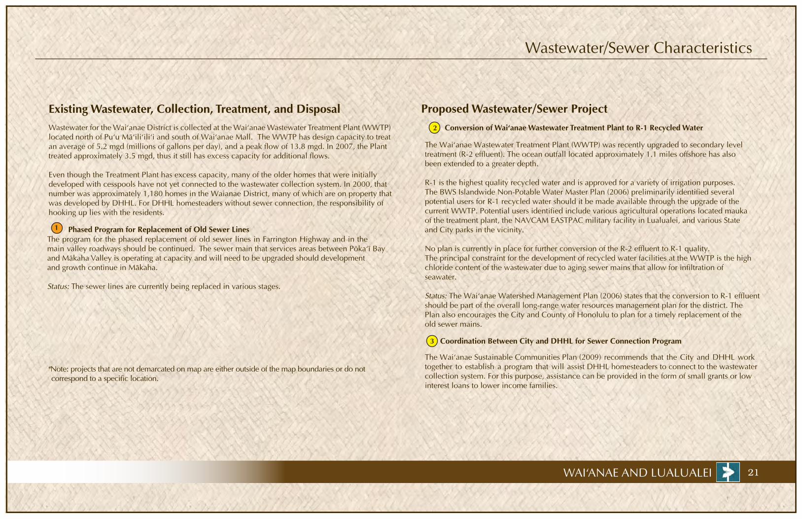
Wastewater/Sewer Characteristics
Existing Wastewater, Collection, Treatment, and DisposalWastewater for the Wai‘anae District is collected at the Wai‘anae Wastewater Treatment Plant (WWTP) located north of Pu‘u Mä‘ili‘ili‘i and south of Wai‘anae Mall. The WWTP has design capacity to treat an average of 5.2 mgd (millions of gallons per day), and a peak flow of 13.8 mgd. In 2007, the Plant treated approximately 3.5 mgd, thus it still has excess capacity for additional flows.
Even though the Treatment Plant has excess capacity, many of the older homes that were initially developed with cesspools have not yet connected to the wastewater collection system. In 2000, that number was approximately 1,180 homes in the Waianae District, many of which are on property that was developed by DHHL. For DHHL homesteaders without sewer connection, the responsibility of hooking up lies with the residents.
Phased Program for Replacement of Old Sewer Lines The program for the phased replacement of old sewer lines in Farrington Highway and in the main valley roadways should be continued. The sewer main that services areas between Pöka‘ï Bay and Mäkaha Valley is operating at capacity and will need to be upgraded should development and growth continue in Mäkaha.
Status: The sewer lines are currently being replaced in various stages.
1
3 Coordination Between City and DHHL for Sewer Connection Program
The Waiÿanae Sustainable Communities Plan (2009) recommends that the City and DHHL work together to establish a program that will assist DHHL homesteaders to connect to the wastewater collection system. For this purpose, assistance can be provided in the form of small grants or low interest loans to lower income families.
Proposed Wastewater/Sewer Project 2 Conversion of Wai‘anae Wastewater Treatment Plant to R-1 Recycled Water
The Waiÿanae Wastewater Treatment Plant (WWTP) was recently upgraded to secondary level treatment (R-2 effluent). The ocean outfall located approximately 1.1 miles offshore has also been extended to a greater depth.
R-1 is the highest quality recycled water and is approved for a variety of irrigation purposes. The BWS Islandwide Non-Potable Water Master Plan (2006) preliminarily identified several potential users for R-1 recycled water should it be made available through the upgrade of the current WWTP. Potential users identified include various agricultural operations located mauka of the treatment plant, the NAVCAM EASTPAC military facility in Lualualei, and various State and City parks in the vicinity.
No plan is currently in place for further conversion of the R-2 effluent to R-1 quality. The principal constraint for the development of recycled water facilities at the WWTP is the high chloride content of the wastewater due to aging sewer mains that allow for infiltration of seawater.
Status: The Waiÿanae Watershed Management Plan (2006) states that the conversion to R-1 effluent should be part of the overall long-range water resources management plan for the district. The Plan also encourages the City and County of Honolulu to plan for a timely replacement of the old sewer mains.
*Note: projects that are not demarcated on map are either outside of the map boundaries or do not correspond to a specific location.

22 WAI‘ANAE AND LUALUALEI
IV. Infrastructure - Roads and Transit
DHHL Property Boundary
State Road
County Road
Federal Road
Private Road
Safety Improvements from Leihoku St to Makau St
Safety Improvements from Aliÿinui Dr to Mäkua Valley Rd
¯0.5 210
Miles
Hakim
o Rd
Lual
ualei
Hom
este
ad R
d
Waiÿa
nae
Valle
y Rd
Proposed Lands for DHHL homestead development in
partnership with Kamehameha Schools in the Ka Pua
Mäkaha Project
Waiÿanae ValleyHawaiian Homesteads
Freitas & CarlosDairy Projects
Future KS Learning Center
Waiÿanae KaiHawaiian Homesteads
Waiÿanae Coast Comprehensive Health Center
Kaupuni Village
Former Voice of America Site
Princ. Kahanu Estates (Part of Nänäkuli
DHHL Region)
1
2
2
Kaupuni Bridge replacement
Intersection Improvements at Lualualei Homestead Rd
Maipalaoa Bridge replacement
23WAI‘ANAE AND LUALUALEI
Roads and Transit Characteristics
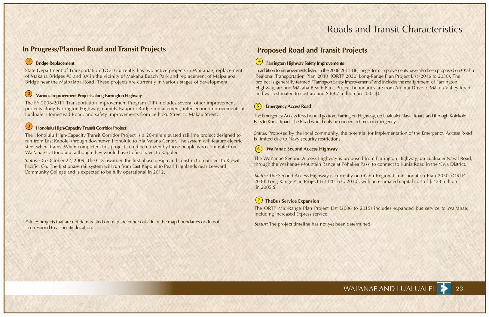
In Progress/Planned Road and Transit Projects
Bridge Replacement
4
Proposed Road and Transit Projects1
Wai‘anae Second Access Highway
The Waiÿanae Second Access Highway is proposed from Farrington Highway, up Lualualei Naval Road, through the Waiÿanae Mountain Range at Pöhakea Pass, to connect to Kunia Road in the ‘Ewa District.
Status: The Second Access Highway is currently on O‘ahu Regional Transportation Plan 2030 (ORTP 2030) Long-Range Plan Project List (2016 to 2030), with an estimated capital cost of $ 423 million (in 2005 $).
Emergency Access Road
The Emergency Access Road would go from Farrington Highway, up Lualualei Naval Road, and through Kolekole Pass to Kunia Road. The Road would only be opened in times of emergency.
Status: Proposed by the local community, the potential for implementation of the Emergency Access Road is limited due to Navy security restrictions.
Farrington Highway Safety Improvements In addition to improvements listed in the 2008-2011 TIP, longer term improvements have also been proposed on O‘ahu Regional Transportation Plan 2030 (ORTP 2030) Long-Range Plan Project List (2016 to 2030). The project is generally termed “Farrington Safety Improvements” and includes the realignment of Farrington Highway, around Mäkaha Beach Park. Project boundaries are from Aliÿinui Drive to Mäkua Valley Road and was estimated to cost around $ 69.7 million (in 2005 $).
Various Improvement Projects along Farrington Highway The FY 2008-2011 Transportation Improvement Program (TIP) includes several other improvement projects along Farrington Highway, namely Kaupuni Bridge replacement, intersection improvements at Lualualei Homestead Road, and safety improvements from Leihoku Street to Makau Street.
State Department of Transportation (DOT) currently has two active projects in Waiÿanae, replacement of Mäkaha Bridges #3 and 3A in the vicinity of Mäkaha Beach Park and replacement of Maipalaoa Bridge near the Maipalaoa Road. These projects are currently in various stages of development.
Honolulu High-Capacity Transit Corridor Project The Honolulu High-Capacity Transit Corridor Project is a 20-mile elevated rail line project designed to run from East Kapolei through downtown Honolulu to Ala Moana Center. The system will feature electric steel-wheel trains. When completed, this project could be utilized by those people who commute from Waiÿanae to Honolulu, although they would have to first travel to Kapolei.
Status: On October 22, 2009, The City awarded the first phase design and construction project to KiewitPacific, Co. The first phase rail system will run from East Kapolei to Pearl Highlands near Leeward Community College and is expected to be fully operational in 2012.
3
2
5
6
TheBus Service ExpansionThe ORTP Mid-Range Plan Project List (2006 to 2015) includes expanded bus service to Wai‘anae, including increased Express service.
Status: The project timeline has not yet been determined.
7
*Note: projects that are not demarcated on map are either outside of the map boundaries or do not correspond to a specific location.

24 WAI‘ANAE AND LUALUALEI
IV. Infrastructure - Public Facilities
n
DHHL Property Boundary
Healthcare Facility
Police Station
Fire Station
Public School
Public Park
Libary
Kaupuni Neighborhood Park
H
Mälama Recovery Facility
In Progress/Planned Project
1
2
Waiÿanae Intermediate
¯0.5 210
Miles
Lual
ualei
Hom
este
ad R
d
Waiÿa
nae
Valle
y Rd
Proposed Lands for DHHL homestead development in
partnership with Kamehameha Schools in the Ka Pua
Mäkaha Project
Waiÿanae ValleyHawaiian Homesteads
Freitas & CarlosDairy Projects
Future KS Learning Center
Waiÿanae KaiHawaiian Homesteads
Waiÿanae Coast Comprehensive Health Center
Kaupuni Village
Former Voice of America Site
n
n
nn nnn Leihoku Elementary
Mäÿili Elementary
Mäkaha Elementary Waiÿanae
Elementary
Waiÿanae Intermediate
Waiÿanae High
Kamaile Intermediate
H2
1
25WAI‘ANAE AND LUALUALEI
Public Facilities Characteristics
Parks
Kaupuni Neighborhood Park
Schools
LibraryThe Wai‘anae Public Library is the only Hawai‘i State Public Library in the Wai‘anae District. It therefore services the entire region. However, in July 2006, Governor Lingle released $46,000 to finance a project development report and master plan to assist the Hawai‘i State Public Library System in planning a new public library in Nänäkuli.
Healthcare Facilities• Kaiser Permanente is located in the Nänäikeola Clinic in Nänäkuli. The facility offers regular health care
services, including family practice, internal medicine, and pediatrics, along with clinical services such asdiabetes education, diagnostic imaging, and nutrition counseling.
• Queen Lili‘uokalani Children’s Center offers services for Hawaiian orphans and destitute children.
•
Police Facilities
Fire/EMT Services
The Wai‘anae District currently has 20 parks from seven different categories. This number, however, constitutes a shortage especially in the number of Neighborhood Parks and in the total acreage of park lands. Development of adequate public parks is a top priority listed in the Wai‘anae Sustainable Communities Plan (2009). The Plan recommends at least one more Neighborhood Park and one additional Community Park be developed by the year 2020.
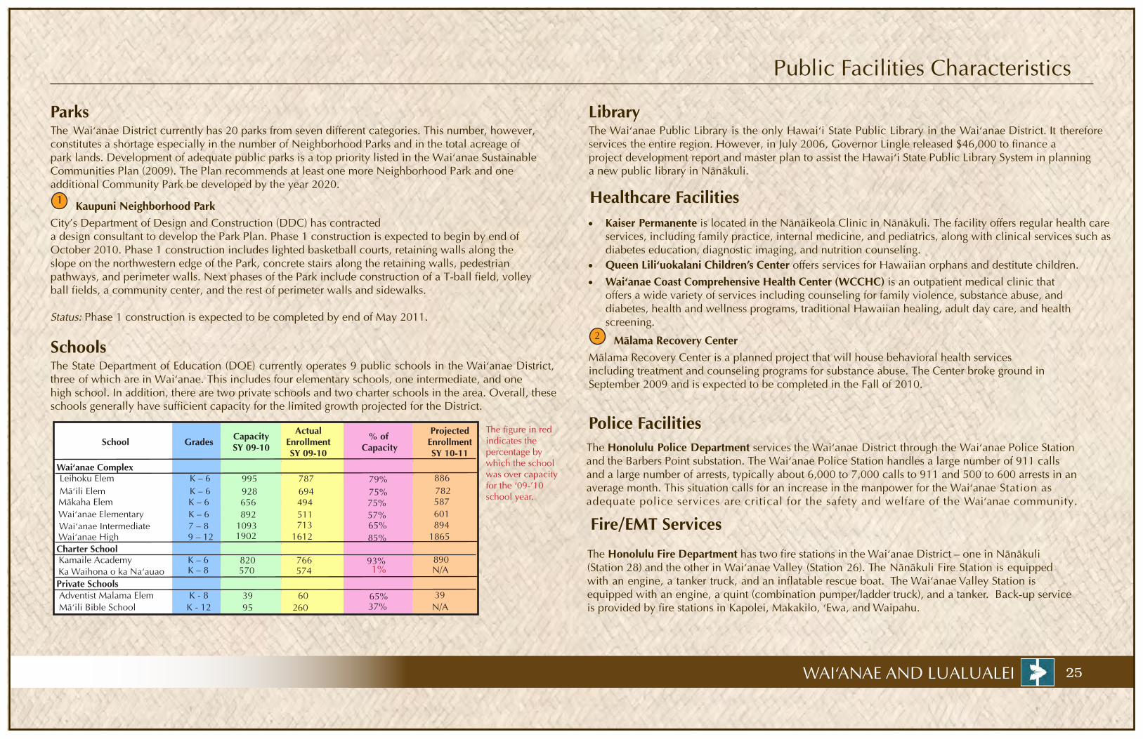
The State Department of Education (DOE) currently operates 9 public schools in the Wai‘anae District, three of which are in Waiÿanae. This includes four elementary schools, one intermediate, and one high school. In addition, there are two private schools and two charter schools in the area. Overall, these schools generally have sufficient capacity for the limited growth projected for the District.
The figure in red indicates the percentage by which the school was over capacity for the ‘09-’10 school year.
School Grades Capacity SY 09-10
Actual Enrollment SY 09-10
% of Capacity
Projected Enrollment SY 10-11
Wai‘anae Complex
Kamaile Academy
Leihoku Elem K – 6Mä‘ili Elem K – 6Mäkaha Elem K – 6Wai‘anae Elementary K – 6
Wai‘anae High 9 – 12Wai‘anae Intermediate 7 – 8
Charter SchoolK – 6
Private SchoolsAdventist Malama Elem K - 8Mä‘ili Bible School K - 12
995928656892
1902
820
39 95
787694494511
1612
766
60260
79%75%75%57%
85%
93%
65%
886782587601
1865
890
39N/A
1093 713 65%
37%
574570 1% N/AK – 8
894
Ka Waihona o ka Na‘auao
Wai‘anae Coast Comprehensive Health Center (WCCHC) is an outpatient medical clinic that offers a wide variety of services including counseling for family violence, substance abuse, and diabetes, health and wellness programs, traditional Hawaiian healing, adult day care, and healthscreening.
2 Mälama Recovery Center
The Honolulu Police Department services the Wai‘anae District through the Wai‘anae Police Stationand the Barbers Point substation. The Wai‘anae Police Station handles a large number of 911 calls and a large number of arrests, typically about 6,000 to 7,000 calls to 911 and 500 to 600 arrests in anaverage month. This situation calls for an increase in the manpower for the Wai‘anae Station as adequate police services are critical for the safety and welfare of the Wai‘anae community.
The Honolulu Fire Department has two fire stations in the Wai‘anae District – one in Nänäkuli (Station 28) and the other in Wai‘anae Valley (Station 26). The Nänäkuli Fire Station is equipped with an engine, a tanker truck, and an inflatable rescue boat. The Wai‘anae Valley Station is equipped with an engine, a quint (combination pumper/ladder truck), and a tanker. Back-up service is provided by fire stations in Kapolei, Makakilo, ‘Ewa, and Waipahu.
1
City’s Department of Design and Construction (DDC) has contracted a design consultant to develop the Park Plan. Phase 1 construction is expected to begin by end of October 2010. Phase 1 construction includes lighted basketball courts, retaining walls along the slope on the northwestern edge of the Park, concrete stairs along the retaining walls, pedestrian pathways, and perimeter walls. Next phases of the Park include construction of a T-ball field, volleyball fields, a community center, and the rest of perimeter walls and sidewalks.
Status: Phase 1 construction is expected to be completed by end of May 2011.
Mälama Recovery Center is a planned project that will house behavioral health services including treatment and counseling programs for substance abuse. The Center broke ground in September 2009 and is expected to be completed in the Fall of 2010.

26
V. Homestead Issues and Priorities - Issues, Opportunities, and Potential Projects
Issues Opportunities/Potential Projects
Speeding on Leihoku Street especially frontingElementary School
Install speed bumps/humps or raised crosswalks on segment of road fronting Leihoku Elementary
DHHL send notes of aloha to remind homesteaders to keep the sidewalks walkable
Quality education forWaiÿanae’s children andyouth
Immersion and/or charter school in Waiÿanae
Identify and determine areas for community use
Develop a center that will educate the public about local history and cultural roots
Need a community center in every homestead
Preliminary ideas: community-run gathering facility with certified kitchen; look at possibility of acquiring Pililäÿau Army Recreation Center for community-run facility
Promote community-based economic development opportunities
Identify potential sites for a cemetery No cemetery space in Waiÿanae
Investigate potential for homestead associations to police common areas
Identify other small and doable projects to address illegal dumping
Develop a feasibility project to reuse gray water People are using more water for watering their yards in Waiÿanae
Develop a program that helps homesteaders hook up to City sewer lines
Sewer bill is expensive Determine possibility of installing separate irrigation water meter to reduce sewer charges
Use of Voice of America site
Development of Voice of America site should include suitable community uses
Older homes in need of repairs
Repair older homes
Develop an energy project to retrofit houses with solar or PV panels and identify funding sources
Homesteaders’ housesneed to be more energy efficient
Need to be moreself-sufficient and sustainable in food production
Preliminary ideas: 1) develop small farm lots in Waiÿanae; 2) develop community gardens at each homestead site; 3) teach backyard aquaponics system
Develop an agriculture master plan for the region in collaboration with agricultural operations in Waiÿanae
Implement the emergency access road through Kolekole Pass
Issues Opportunities/Potential Projects
Traffic along Farrington Highway
Cars parked on the sidewalks in DHHL homesteads
Visitors and local community do not knowmuch about local historyand cultural roots
Provide financial literacy and business education programs for the community
Need financial literacyand business educationprograms in Waiÿanae
Community managementof Kaupuni Park and its community center facilityonce completed
Identify steps toward the implementation of community vision for the Kaupuni Park’s community center
Fix Farrington Highway and other roads to allow for better traffic
Identify suitable sites for community-based economic development projects
Illegal dumping
High costs prohibitmany families from hooking up to City’ssewer lines
Need homestead beautification
Get homesteaders to plant one front tree on every homestead lot
Acquisition of lands leased to Waiÿanae Valley Ranch from Department of Agriculture
Explore possibility of acquiring Mäkua lands for community use DHHL position itself to receive Lualualei lands once Navy’s use is terminated
Traffic
Community Education
Community Use Areas
Acquire nearby lands for community use
Community-Based Economic Development Project
Cemetery
Water, Sewer, and Illegal Dumping
Homesteaders’ Houses
Agriculture and Food Security
WAI‘ANAE AND LUALUALEI

Priority Project: Kaupuni Community Center
Location - Wai‘anae Valley Homestead,TMK 8-5-32:039
Description - The Kaupuni Neighborhood Center occupies a 7.5-acre parcel of land within the Wai‘anae Valley Homesteads. The land is owned by DHHL and is leased to the City until the year 2020. The City has a plan to develop Kaupuni Park, including athletic fields and courts as well as a community center. Upon completion of the community center, the Wai‘anae Valley Homestead Association proposes to manage it for revenue generating activities.
Status - Funding has been secured for Phase I construction. Currently, funding has not been programmed for Phase II, Phase III, and Phase IV construction.
First Phase of Project
Second Phase of Project
Third Phase of Project
Potential Partners - DHHL, Wai‘anae ValleyHomesteads Association, City’s DPR, City’s DDC
CostPhase I: $ 1.15 Million (2009 $)Phase II: $ 1.27 Million (2004 estimate)Phase III: $ 1.12 Million (2004 estimate)Phase IV: N/A
Phasing - Phase I: Lighted basketball courts, retaining walls along the slope on the northwestern edge of the park, concrete stairs along the retaining wall, pedestrian pathways connecting the retaining wall and Punanaula Street, perimeter walls along Kaneaki Street and around the end of Punanaula Street. Phase II: Multi-purpose fieldPhase III: Community centerPhase IV: T-ball field, volley ball field, keiki lot
27WAI‘ANAE AND LUALUALEI
10 1211 1110 9 8 7 6 5 4 3 2 1 12 Project Sequence
Project Design
2009 2010 2011
Phase-1Bidding andAwarding of Contract
Phase I Construction
2012
Next Phases Construction
1110 9 8 7 6 5 4 3 2 1 12 3 2 1

28
V. Homestead Issues and Priorities - Priority Project: Waiÿanae Kai Community Development
Potential Partners - DHHL, WKHHA, Hawaiian Community Development, HECO
Location - DHHL lands in the vicinity of WaiÿanaeKai Homesteads.
Cost - Not yet determined
Status - The WKHHA in collaboration with Hawaiian Community Development is currently developing conceptual plans for Waiÿanae Kai Ridgeside, an affordable rental housing project on the ÿEwa side of Paheÿeheÿe Ridge. The WKHHA is also developing plans for PV farms and community parks with sports facilities at nearby locations. For these projects, the WKHHA needs to secure a long term lease.
Description - The Waiÿanae Kai Hawaiian Homestead Association (WKHHA) is planning several projects on DHHL lands located in the vicinity of the Waiÿanae Kai Homesteads. The concept is to develop both revenue-generating and community facilities, including a photovoltaic (PV) farm, a community center, and küpuna and transitional housing.
Project Schedule
Phasing - Phase I: Establishment of a formal organization, typically a non-profit corporation and development of organization’s vision, mission, and goals. Phase II: Preliminary project planning including identification of potential projects and applying for implementation grants. Phase III: Project implementation steps, including: 1) development of business plans, securing site, property assessment, and development of plans and cost estimates; 2) partnership building, financing, and negotiation with developers; 3) design and constructionPhase IV: Marketing and management for a sustainable project
Establishment ofFormal Organization
2010
Project Implementation Phase
2011 2012
Marketing and Management
5 4 3 2 1
WAI‘ANAE AND LUALUALEI
Preliminary Project Planning
2013
DHHL Property Boundary
Public Parks
Farrington Highway
10 9 8 7 6 5 4 3 2 110 9 8 7 6 5 4 3 2 1 1211
Waiÿanae Kai Homesteads
Waiÿanae Coast ComprehensiveHealth Center
Leiho
ku S
t
Planned PV farms on a 2 acres lot adjacent to Waiÿanae Kai Ridgeside Development
Planned Waiÿanae Kai Ridgeside Development on a 34-acre lot:- 20 single family units- 100 multi-family units- a community center
Future Waiÿanae Kai Park (See adjacent site map)
Lualualei
Homestead Rd
Halon
a Rd
Leihoku Elementary

29
Priority Project: Waiÿanae Transportation Corridor Coordination and Improvements
Potential Partners - Waiÿanae Kai Homestead Association, Waiÿanae Valley Homestead Association, DHHL, DOT, City’s Government and Public Utilities Task Force
Location - Farrington Highway from Hakimo Road to Maluÿu Road.
Cost - Not yet determined
Status - Currently, when work needs to be completed along Farrington Highway, the agency usually schedulesa public meeting or addresses the Neighborhood Boards to inform them of their work. There was a recent infrastructure coordination body (City’s Government and Public Utilities Task Force) that was created which may be useful in implementing this Priority Project.
Description - To provide coordination among all stakeholders with the ultimate goal of providing relief for Waiÿanae/Nänäkuli coast residents which have had to deal with years of constant interruptions along Farrington Highway. Improvements to coordinate include corridor beautification, undergrounding of utilities, utility repairs, roadway widening where appropriate, and construction of traffic and safety improvements.
Project Schedule
Phasing - Phase I : Identify a core group of homesteadersthat can work on this project. DHHL call meeting of stakeholders to determine what can be done to implement the project.Phase II: Stakeholders develop a Plan of Action forapproval/consent by affected agencies. Phase III: Coordinated road construction
Core group identification and stakeholder meetings
2010 20111110 9 8 7 6 5 4 3 2 1 12
2012
Development of Plan of Action
1110 9 8 7 6 5 4 3 2 1 12 1110 9 8 7 6 5 4 3 2 1 12
Coordinated road construction
WAI‘ANAE AND LUALUALEI
Hak
imo
Rd
St. Jo
hns R
d
Leiho
ku St
Farrington Hwy
Malu
ÿu R
d
DHHL Properties Boundary
Public Parks
Farrington Highway
30
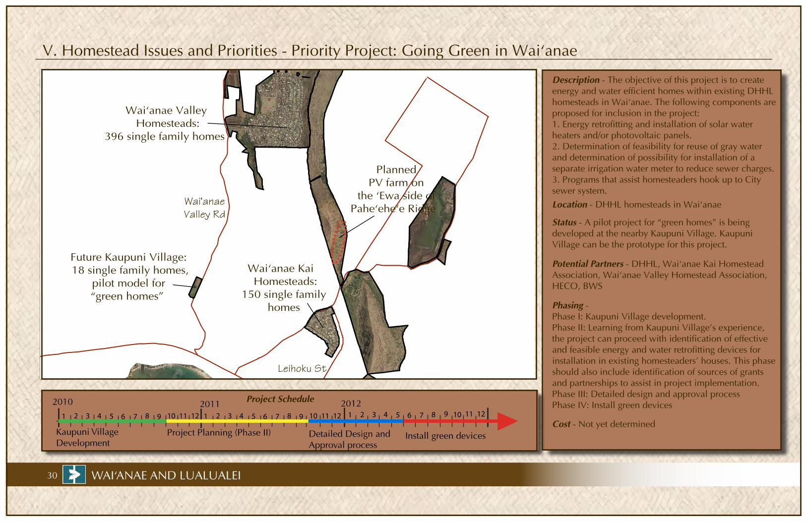
V. Homestead Issues and Priorities - Priority Project: Going Green in Waiÿanae
Potential Partners - DHHL, Waiÿanae Kai Homestead Association, Waiÿanae Valley Homestead Association, HECO, BWS
Location - DHHL homesteads in Waiÿanae
Cost - Not yet determined
Status - A pilot project for “green homes” is being developed at the nearby Kaupuni Village. Kaupuni Village can be the prototype for this project.
Description - The objective of this project is to createenergy and water efficient homes within existing DHHL homesteads in Waiÿanae. The following components areproposed for inclusion in the project:1. Energy retrofitting and installation of solar water heaters and/or photovoltaic panels. 2. Determination of feasibility for reuse of gray water and determination of possibility for installation of a separate irrigation water meter to reduce sewer charges.3. Programs that assist homesteaders hook up to Citysewer system.
Project Schedule
Phasing - Phase I: Kaupuni Village development. Phase II: Learning from Kaupuni Village’s experience, the project can proceed with identification of effective and feasible energy and water retrofitting devices for installation in existing homesteaders’ houses. This phase should also include identification of sources of grants and partnerships to assist in project implementation. Phase III: Detailed design and approval process Phase IV: Install green devices
1110 9 8 7 6 5 4 3 2 1 12
Kaupuni Village Development
2010
Project Planning (Phase II)
2011 2012
Detailed Design andApproval process
1110 9 8 7 6 5 4 3 2 1 12 8 7 6 5 4 3 2 1
WAI‘ANAE AND LUALUALEI
Install green devices
12 11 10 9
Waiÿanae Valley Homesteads:
396 single family homes
Future Kaupuni Village: 18 single family homes,
pilot model for “green homes”
Waiÿanae Valley Rd
Leihoku St
Waiÿanae Kai Homesteads:
150 single family homes
Planned PV farm on
the ÿEwa side of Paheÿeheÿe Ridge

Priority Project: Agriculture/Aquaculture Production and Food Security
Location - DHHL lands in Waiÿanae
Description - The decline in agricultural operations in Waiÿanae is alarming given the importance of food security in the context of Hawaiÿi’s geographical isolation. Active cultivation of agricultural land is of critical importance to the revitalization of agriculture in Waiÿanae. Equally important is the development and support for subsistence agriculture, within smaller residential lots. This project aims at providing educational and training programs that would allow existing lessees to engage in agricultural production for subsistence or for supplementalincome.
Status - A pilot project for community and backyard aquaponics system is being developed at Kaupuni Village.
Cost - Not yet determined
Potential Partners - Waiÿanae Kai Homestead Association, Waiÿanae Valley Homestead Association, Ka‘ala Farm, MA‘O Organic Farm, OPELU project, other farmers, localfishermen, community gardeners, DHHL, DLNR, DOA, UH-CTAHR Phasing - Phase I: Development of Kaupuni Village, including the establishment of aquaponics system training at the Village; Phase II: Development of agriculture master plan for Waiÿanae. The master plan should include components such as development of DHHL agricultural lots and identification of strategic steps toward acquisition of more lands for future farms. Additionally, using experiences from the Kaupuni model, identify effective programs that teach community/backyard farming. Programs that establish linkages between homesteaders and local agriculture/aquaculture practitioners should also be pursued; Phase III: Agricultural site construction and program implementation
Project Schedule
DHHL Lands in Waiÿanae
Ka‘ala Farm, Inc.
MA‘O Organic Farm
Public Parks
31WAI‘ANAE AND LUALUALEI
1110 9 8 7 6 5 4 3 2 1 12
2010 2011 20121110 9 8 7 6 5 4 3 2 1 12 8 7 6 5 4 3 2 1
Kaupuni Village Development
Agricultural MasterPlan Development
Agricultural Site Construction and Program Implementation
Lual
ualei
Hom
este
ad R
d
Waiÿa
nae
Valle
y Rd
Proposed Lands for DHHL homestead development in
partnership with Kamehameha Schools in the Ka Pua
Mäkaha Project Waiÿanae ValleyHawaiian Homesteads
Freitas & CarlosDairy Projects
Future KS Learning Center
Waiÿanae KaiHawaiian Homesteads
Waiÿanae Coast Comprehensive Health Center
Kaupuni Village:Pilot project for- “green homes”- backyard aquaponic systems Former Voice of
America Site
Waiÿanae ValleyRanch

DEPARTMENT OF HAWAIIAN HOME LANDS