wahroonga to mt kuring-gai - wildwalks.comdownloads.wildwalks.com/wahroonga to mt kuring-gai... ·...
TRANSCRIPT

Wahroonga to Mt Kuring-gaiWahroonga to Mt Kuring-gai
Starting with a walk through the streets ofWahroonga, this walk then heads bush, followingthe Gibberagong Track to Bobbin Head. After apicnic or a bite to eat from the kiosk, the walk thenheads up the Birrawanna track to lead to AppleTree Bay. From here the track follows thepicturesque Cowan Creek for a while beforeheading up the ridge to Mt Kuring-gai Station.Ku-ring-gai Chase National Park
Length:Time:Climb:Style:Rating:Where:Transport:
14.7 km5 hrs 30 mins607 mOne wayTrack: Hard0.1 km SSE of Wahroongabus car train
Visit www.wildwalks.com for more infoSide trips and Alternate routes mentioned in these notes are not included in the tracks overall rating, distance or time estimate. The notes only describe the sidetrips and Alternate routes in one direction. Allow extra time for resting and exploring areas of interest. Please ensure you and your group are well preparedand equipped for all possible hazards and delays. The authors, staff and owners of wildwalks take care in preparing these notes but will not acceptresponsibility for any inconvenience, loss or injury sustained by using these notes or maps. Please take care and share your experience through the website.Please check park closures, weather information and Fire Danger Rating just before leaving for your walk. Walk maybe closed during Total Fire Ban.GPS for start the start of this walk:-33.7176,151.1171 & for the end:-33.6538,151.1367
Wildwalks April & May 2014 bushwalking Magazine. Download the full magazine for free Bushwalk Australia eMag The eMagazine is produces by the community at bushwalk.com and the Wildwalks team Bushwalk.com Australia's most active bushwalking forum - Check it out. Happy Reading. Matt :)
Wahroonga Railway Station to End of Grosvenor St 2.9km 50 mins (From S) From Wahroonga Station, this walk heads north along Illoura Av, away from the round-about. The walk sooncrosses Millewa Ave at the pedestrian crossing, then passes alongside Wahroonga Park (to the left). At the end of thepark, the walk turns right into Stuart St (at the round-about) then left onto Cleveland St at the next roundabout. At the endof Cleveland St, the walk turns right onto Burns Road then immediately left onto Grosvenor St. The walk then followsGrosvenor St for approximately 2km to the end, where there is a green gate at the start of a management trail.
End of Grosvenor Rd to Gibberagong Track Lookout Int. 0.1km 2 mins (From 2.93 km) Continue straight: From the very end of Grosvenor Rd (Wahroonga), this walk follows the managementtrail gently downhill around the locked green metal gate and past the 'No through road' sign. The trail leads through a dipamong a scribly gum forest for just over 100m to an intersection with a track (on your left)marked with a 'Ku-ring-gai Chase National Park - Gibberagon Trail sign.
Gibberagong Track Lookout Int. to Gibberagong Lookout 0.5km 5 mins Optional Side Trip: (From 3.05 km) Veer left: From the intersection, this walk follows the northbound track, away from the management trailfrom behind the NPWS arrow post. This walk follows this mostly flat track for just shy of 100m to continue straight at faintintersection with another track (on your left). The track soon begins to narrow and leads gently downhill, towards thefreeway noise for another 300m to a rock platform with some filtered distant views(Retrace your steps back to the main track, then turn left to continue along this walk.)
Gibberagong Lookout This informal lookout is in the south-western corner of Ku-Ring-Gai Chase National Park, near the end of Grosvenor St,Wahroonga. The lookout give a view across the valley of bushland, the freeway cutting and the lights from Mills Park inAsquith.
Gibberagong Track Lookout Int. to End of Gibberagong trail 1.2km 20 mins (From 3.05 km) Veer right: From the intersection, this walk follows the NPWS arrow post gently uphill along the widetrail, following the ridge line over a gently rise. After about 350m this walk leads past a small clearing (on your right).Here the walk continue downhill through the scribbly gum forest for another 900m to where the trail bends sharply right(to end) and comes to an intersection with the fairly wide Gibberagon Track (on your left, part way around the bend).
Page 1/9 PDF generated on 26 Jun 2014

Wahroonga to Mt Kuring-gaiWahroonga to Mt Kuring-gai
End of Gibberagong trail to Gibberagong AND Murrua Track Int. 0.8km 15 mins (From 4.29 km) Veer left: From the intersection, this walk follows the fairly wide Gibberagong Track north east, gentlydownhill. The track soon starts to narrow and lead a little steeper down a series of timber steps for about 80m beforeheading down through a notably steep rocky pass. Here the track continues to winds down the ridge moderately steeplyfor just shy of 250m, to step down a rock pass around a right hand hair-pin bend. Then just 30m later the track bendssharply left at another hair-pin bend then just shy of 50m laterthe track bends sharply right again. From here the track leads down the series of timber and stone steps through thencasurina forest for about 200m to come to a 'Bobbin Head' sign, just before distinct gully. Here the walk veers left(following the arrow on the sign) and heads down the bank to cross Lovers Jump Creek on the mossy rocks with carvedsteps. After heading up the other bank this walk follows the clear track near Cockle Creek for just shy of 100m to a moreopen section providing clearer views over the creek and the southern section of Gibberagong Waterholes. From here thetrack then leads further down the widening valley through the tall eucalypt and stringy bark forest for 100m to aintersection with a faint track (on your right) at a tall smooth bark angophera, marked with an obvious sign pointing back'To Grosvenor Street'.
Int of Gibberagong and Murrua Link Tracks to Gibberagong waterhole 0km 1 mins (From 5.09 km) Continue straight: From the intersection, beside the large smooth bark angophera, this walk follows the'To Bobbin Head' sign along the clear track gently downhill, keeping the creek a short distance to your left, for about 20mto pass a section of metal fencing propped up by a tree. The walk continues for another 10m or so to come to a flat areabeside the northern end of Gibberagong waterholes, this is just before the track crosses a small side creek.
Gibberagong waterhole Gibberagong waterhole is an informal name for a wide section of Cockle Creek that run for over 150m north of theconfluence with Lovers Jump creek. This secluded and shady spot is a great place to sit and enjoy the waterholes,cascading water and the view to the sandy banks on the other side. If you sit quietly enough you may see lyrebirdsscratching through the bush by the creek.
Gibberagong waterhole to Int of Bobbin Head and Rainforest tracks 3.2km 1 Hrs 5 mins (From 5.12 km) Continue straight: From beside the northern end of Gibberagong waterholes, this walk follow the trackalong the waters edge, keeping Cockle Creek to your left. After 25m this walk crosses a small side creek them followsthe track gently uphill for just shy of 100m to pass a rock platform (on your left), with a good view over this bend inCockle Creek. The track continues up the side of the hill for another 100m to pass alongside an 2m high natural rock wallthen about 120m later this walk leads back down close to the edge of the creek. Just over 120m later the track leadsunder two tall over hangs (the first overhang has a notable hole high in the roof), then just over 100m later the trackleads under a set of power lines (a bit tricky to see through the canopy). From here the track continues to gently undulatealong the side of the hill, in view of the creek, for just over 1km to come back down to a pleasant, fairly open forest on asandy bank beside a long pool on Cockle Creek (with a few small cascades upstream). The track continues downstreamfor another 100m to cross over a mostly but mostly flat rock platform then over the next 200m the track leads up the sideof the hill to cross a shallow gully with several tall palms among the mostly tall eucalypt forest. Here the track passesunder a two sets of high tension power lines. The track continues to undulate along the side of hill for another 200m tolead down to to the rocky creeks edge again, near the upper reaches of the tidal section of the creek. From here the nowmostly flat track continues downstream beside the creek for 300m to come to a notably flat and open sandy area withsome bracken fern beside the creek[ref img=427709, then 50m later to walk leads along side a tall 150m long naturalrock wall. The track then leads alongside the tidal section of Cockle Creek among the mixed forest of casuarina, grasstrees and tall eucalypt for just shy of 300m to then head through a 200m long section section of mangroves with ascattering of open casuarina forest. Here the rocky track leads up the side of the hill, up a few steps to the top of theridge line. Just as the track comes to the top of this hill it bends right and comes to a three-way intersection, where a'Wahroonga 5km' sign points back down the track.
Int of Bobbin Head and Rainforest tracks to Bobbin Head Rainforest 0.2km 5 mins Optional Side Trip: (From 8.32 km) Continue straight: From the intersection, this walk follows the 'Rainforest 500m' sign gently uphill alongthe clear track heading south east. After about 60m the track starts to lead gently down the side of the hill among thegrass tree and eucalypt forest for about 100m before leading down a series of timber steps into the more densely forestgully. Here the walk comes to a sandstone rock bed and creek in a pleasant rainforest setting.(Retrace your steps back to the main track, then turn right to continue along this walk.)
Page 2/9 PDF generated on 26 Jun 2014

Wahroonga to Mt Kuring-gaiWahroonga to Mt Kuring-gai
Bobbin Head Rainforest A well-protected piece of rainforest is found just a short walk from the popular Bobbin Head picnic area in Ku-Ring-GaiChase National Park. The rainforest is distinct when compared to much of the dry eucalypt forests that dominate thearea. The rainforest is beside a small creek, just below Bobbin Head Road, and is a safe haven for many birds thatfrequent the area.
Int of Bobbin Head and Rainforest tracks to Aboriginal Axe Grindings 0km (From 8.32 km) Turn left: From the intersection, this walk follows the 'Bobbin Head 500m' sign, gently downhill followingthe track along the main ridge line for just shy of 20m to the signposted Aboriginal 'Axe Grinding Grooves' site (which ison a short detour track, on your right).
Aboriginal Axe Grindings This protected site clearly shows 23 oval-shaped grooves that were worn by Indigenous Australian people, making axeheads from hard rock. Using a blank axe head, the Aboriginal people would use this rock platform, with water from thenearby creek, to sharpen the stone into a useful tool. The rubbing ground the axe head to a sharp edge and left behindthese tell-tale signs. More info
Aboriginal Axe Grindings to South End of Bobbin Head Park 0.6km 5 mins (From 8.35 km) Continue straight: From the Aboriginal 'Axe Grinding Grooves' site this walk follows the track gentlydownhill along the ridge, initially keeping the grinding site to your right. After about 20m this walk heads down somesandstone steps the continues for another 60m along the sandy track down more steps then up to the top of a small risewhere the is a unfenced view over the water (just off the track to your left). Here the walk continues generally down alongthe ridge for just shy of 300m where the track leads over a rock platform before heading down some steps that leadthrough a cleft in the rock. The track then leads past a small sandstone overhang to head down a timber ramp to find atimber boardwalk, marked with a 'More?' sign. Continue straight: From the 'More? you want more?' information sign, this walk follows the timber boardwalk as it windsamong the mangroves and saltmarsh. The boardwalk leads past the 'Land Developers?' and 'Natural Recycler' information signs as it winds for about 100m to a fenced viewing areamarked with a 'Teeming with life!' information sign. Continue straight: From the viewing area, this walk follows the fenced timber boardwalk keeping the main body of visiblewater to your right. After about 20m this walk crossed Cockle Creek on a cable-stayed foot bridge, with some great waterand cliff views. On the other side the footpath then bends right to find a sandstone cave with a 'Rock Solid?' informationsign. Here the walk continues along the patterned concrete path as it gently bend left over about 50m to find thesheltered 'Welcome to the Mangrove Boardwalk AND Gibberagong Track' information sign (on your left). This walk thencontinues along the footpath for another 20m to the car park and a small constructed sandstone wall with a 'GibberagongTrack. Mangrove Boardwalk.' sign.
South End of Bobbin Head Park to Bobbin Head Kiosk 0.5km 5 mins (From 8.95 km) Veer right: From the southern end of the car park, this walk heads away from the face of the'Gibberagong Track Mangrove Boardwalk' sign following the asphalt footpath beside the car park, keeping the water toyour right. After about 100m this walk heads past the signposted 'Canoe Launch Area' then continues along thecompacted dirt foreshore path for 100m where the path becomes asphalt again to lead past the children's play ground forjust over 50m to the sandstone steps (that provide access to Cockle Creek). The walk continues along the foreshorepath for almost 200m until just before the road bridge over Cockle Creek, where the now brick paved path bends left.Here the walk crosses the car park entrance and continues straight, over the grass to the back of 'Bobbin Inn' cafe, justbeside Ku-Ring-Gai Chase Rd (on your right).
Bobbin Head Bobbin Head is a historic recreation area which is still popular today, suiting the needs of many people. At the center ofthe Bobbin Head area is the old "Bobbin Inn", built in the 1930s - it is now the park information center and kiosk. Thearea is popular with picnickers, boaters, walkers, canoeists, family groups and people who like to fish. Bobbin Head isroughly divided into three sections (north, south and east). Southern Bobbin Head is a popular picnic area for families and large groups. The area is surrounded by a car park anddotted with picnic tables, electric BBQs, shelters and children's play equipment. There are toilets nearby, and two largeshelters can be booked through the NPWS.The northern Bobbin Head (Orchard Park) area is a more formal picnic area. There is a large picnic shelter, surroundedby 14 smaller octagonal shelters, each of these divided into 4 walled-off compartments, ideal for small groups. Theeastern side of Bobbin head is dominated by the Empire Marina and public wharf. The marina is home to a nicerestaurant and public toilets. More info
Page 3/9 PDF generated on 26 Jun 2014

Wahroonga to Mt Kuring-gaiWahroonga to Mt Kuring-gai
Bobbin Inn Cafe, Bobbin Head At the centre of Bobbin Head, this cafe offers inside and outdoor dining, and a range of foods and drinks. Food includesfish and chips, wraps, focaccia, sandwiches and snack foods. Tea, coffee and cold drinks are also on offer. The oldsandstone building is also home to the information centre and was once the Bobbin Inn. Opening hours are 9 - 4pm Monto Fri (closed Tuesdays) & 9 - 5pm weekends. For more information, phone the cafe on 9457 7170.The NPWS Bobbin Head Information Centre is open 7 days a week (closed Christmas Day) 10 - 4pm (closed 12 -12:30pm lunch).
Bobbin Inn Cafe to Bottom of the Birrawana track steps 0.2km 4 mins (From 9.45 km) Continue straight: From the 'Bobbin Inn' cafe, this walk heads to the front of the building to the'Information Centre' main entrance. From here this walk follows the 'Birrawana Loop Track' alongside the road a fewmeters to find a metal 'Welcome to the Cockle Creek Lookout Track' sign and map. Now the walk follows the trackbehind the safety barrier (keeping the road to your right) for about 70m to cross a small culverted creek and pass a fewold a couple of picnic tables in a shaded and mossy gully. This walk continues for another 30m behind the safety barrierto come to the bottom of the signposted 'Birrawanna Track' steps.
Int of Birrawana track and Ku-Ring-Gai Chase Road to Int of Birrawana and Cockle Creek Lookout tracks 0.3km5 mins (From 9.61 km) Veer left: From beside Ku-Ring-Gai Chase Road, this walk heads down a few steps to cross a small flatconcrete bridge, to then follow the 'Birrawanna Track' sign up the timber steps. This walk leads quite steeply up the trackas it zig-zags up a series of timber and rock steps for just over 300m to find the top of small rocky ridge. Here the walkleads down a series of timber steps for about 50m to cross a moist gully that is home to a disused telegraph pole. Nowthis walk follows the clear rocky track leads uphill for just shy of 200m to come to a faint intersection at the top of theridge (where the lookout track is on your right). Int of Birrawana and Cockle Creek Lookout tracks to Cockle Creek Lookout 0.1km 3 mins Optional Side Trip: (From 9.91 km) Turn right: From the intersection, this walk follows the rocky track, east along the top of the ridgelinetowards the rocky outcrop. After about 50m this walk passes through a gap between two large rock outcrops, thenaround another rock to wind gently down the hill for just shy of 50m to come to an unfenced rock ledge overlookingCockle Creek.(Retrace your steps back to the main track, then turn right to continue along this walk.)
Cockle Creek Lookout Cockle Creek Lookout is an informal lookout with no facilities, on the Birrawanna track in Ku-Ring-Gai Chase NationalPark. The lookout provides Glimpses of Cockle and Cowan Creeks. The area is surrounded by some beautiful gum treesand rock boulders, making it a nice place to sit and reflect on the surroundings.
Int of Birrawana and Cockle Creek Lookout tracks to National Parks Regional Office 0.4km 5 mins (From 9.91 km) Continue straight: From the intersection, this walk heads north gently down hill for a few meters to followan NPWS arrow post along the clear track. After just shy of 100m this track bends left to then gently undulate along theside of the hill (with the road down to your right) for about 300m. Here the track mostly flattens out and contours aroundthe side of the hill for about 150m to then lead up a very gently hill to a signposted three way intersection. Theintersection is beside a small clearing behind the regional office (on your right) and is marked with a 'Cockle CreekLookout' and 'Bobbin Head' sign pointing back along the track. Veer right: From the intersection, the walk head gently uphill across the grassy clearing, veering left a little to headacross the car park and come the the driveway entrance of the sandstone National Parks Regional Office building.
NPWS North Sydney Regional Office The NPWS North Sydney Regional Office is a lovely stone building on Bobbin Head Road at one of the trackheads forBirrawanna loop track. There is a car park and an open grassy area. On the opposite side of the road is the Apple TreeFlat Picnic Area with a few picnic tables. Other than this, there are no public facilities.
National Parks Regional Office to Apple Tree Flat Picnic Area 0km 1 mins (From 10.32 km) Veer right: From the the NPWS Regional office, this walk heads out of the car park and crossesKu-Ring-Gai Chase Road, veering right to find a small clearing on the other side. From the clearing, the walk headsdown some stone steps to almost immediately come to an intersession marked with an 'Apple Tree Flat' sign just besidethe picnic area.
Page 4/9 PDF generated on 26 Jun 2014
Wahroonga to Mt Kuring-gaiWahroonga to Mt Kuring-gai
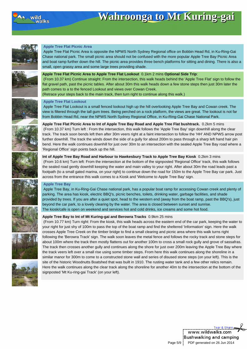
Apple Tree Flat Picnic Area Apple Tree Flat Picnic Area is opposite the NPWS North Sydney Regional office on Bobbin Head Rd, in Ku-Ring-GaiChase national park. The small picnic area should not be confused with the more popular Apple Tree Bay Picnic Areaand boat ramp further down the hill. The picnic area provides three bench platforms for sitting and dining. There is also asmall, open grassy area and some large trees providing shade.
Apple Tree Flat Picnic Area to Apple Tree Flat Lookout 0.1km 2 mins Optional Side Trip: (From 10.37 km) Continue straight: From the intersection, this walk heads behind the 'Apple Tree Flat' sign to follow theflat gravel path, past the picnic tables. After about 30m this walk heads down a few stone steps then just 30m later thepath comes to a to the fenced Lookout and views over Cowan Creek.(Retrace your steps back to the main track, then turn right to continue along this walk.)
Apple Tree Flat Lookout Apple Tree Flat Lookout is a small fenced lookout high up the hill overlooking Apple Tree Bay and Cowan creek. Theview is filtered through the tall gum trees. Being perched on a rock platform, the views are great. The lookout is not farfrom Bobbin Head Rd, near the NPWS North Sydney Regional Office, in Ku-Ring-Gai Chase National Park.
Apple Tree Flat Picnic Area to Int of Apple Tree Bay Road and Apple Tree Flat bushtrack. 0.2km 5 mins (From 10.37 km) Turn left : From the intersection, this walk follows the 'Apple Tree Bay' sign downhill along the cleartrack. The track soon bends left then after 30m veers right at a faint intersection to follow the 'HH' AND NPWS arrow postfurther downhill. The track the winds down the side of a gully for about 200m to pass through a sharp left hand hair pinbend. Here the walk continues downhill for just over 30m to an intersection with the sealed Apple Tree Bay road where a'Regional Office' sign points back up the hill.
Int of Apple Tree Bay Road and Harbour to Hawkesbury Track to Apple Tree Bay Kiosk 0.2km 3 mins (From 10.6 km) Turn left: From the intersection at the bottom of the signposted 'Regional Office' track, this walk followsthe sealed road gently downhill keeping the water and main valley to your right. After about 30m the road leads past afootpath (to a small gated marina, on your right) to continue down the road for 150m to the Apple Tree Bay car park. Justacross from the entrance this walk comes to a Kiosk and 'Welcome to Apple Tree Bay' sign.
Apple Tree Bay Apple Tree Bay, in Ku-Ring-Gai Chase national park, has a popular boat ramp for accessing Cowan creek and plenty ofparking. The area has kiosk, electric BBQ's, picnic benches, toilets, drinking water, garbage facilities, and shadeprovided by trees. If you are after a quiet spot, head to the western end (away from the boat ramp, past the BBQ's), justbeyond the car park, to a lovely clearing by the water. The area is closed between sunset and sunrise.The kiosk/cafe is open on weekend and services hot and cold drinks, ice creams and some hot food.
Apple Tree Bay to Int of Mt Kuring-gai and Berowra Tracks 0.9km 25 mins (From 10.77 km) Turn right: From the kiosk, this walk heads across the eastern end of the car park, keeping the water toyour right for just shy of 100m to pass the top of the boat ramp and find the sheltered 'Information' sign. Here the walkcrosses Apple Tree Creek on the timber bridge to find a small clearing and picnic area where this walk turns rightfollowing the 'Berowra Track' sign. The walk soon leaves the metal fence and follows the rocky track and stone steps forabout 100m where the track then mostly flattens out for another 100m to cross a small rock gully and grove of sassafras.The track then crosses another gully and continues along the shore for just over 200m leaving the Apple Tree Bay wherethe track veers left over a small rise using some timber steps. From here this walk continues along the shoreline in asimilar manor for 300m to come to a constructed stone wall and series of disused stone steps (on your left). This is thesite of the historic Woodnutts Boatshed that was built in 1910. The rusting water tank and a few other relics remain.Here the walk continues along the clear track along the shoreline for another 40m to the intersection at the bottom of thesignposted 'Mt Ku-ring-gai Track' (on your left).
Page 5/9 PDF generated on 26 Jun 2014

Wahroonga to Mt Kuring-gaiWahroonga to Mt Kuring-gai
Int of Mt Kuring-gai and Berowra Tracks to Int of Lookout and Mt Kuring-gai Tracks 1.9km 45 mins (From 11.7 km) Turn left : From the intersection, this walk follows the 'MT Ku-ring-gai Track' sign up the rock and timbersteps and past the small overhang. The track leads fairly steeply up for 80m to then bend sharply right and continue fairlysteeply for another 200m to pass a natural rock wall (on your left). Just 20m past this wall the track comes to a small flatarea with good views over Cowan Creek. Here the walk continues more gently uphill along the rocky ridge line for 300mwhere the track completely flattens out to pass along the side of a small hill (on your left). Over the next 600m the trackleads down across a saddle then up along the ridge to bend right onto an exposed rock platform. From there the sandytrack soon bends left again to follow the ridge uphill for 100m to pass a small sandstone overhang then continue up along set of stone steps where the sandy track mostly flattens out again. Soon the track starts heading up more stonesteps for about 400m to pass between a large boulder (on your left) and along rock wall (on your right). At the end of thisrock wall the track bends right and leads up the stone steps through the cleft in the rock where the then mostly flat widesandy track leads gently uphill for 250m to find a three-way intersectionmarked with a NPWS arrow post.
Int of viewpoint and Mt Kuring-gai Tracks to Apple Tree Bay Viewpoint 0.1km 2 mins Optional Side Trip: (From 13.64 km) Turn left : From the intersection, the walk heads east away from the main trail to follow the wide sandytrack gently downhill. The track begins to narrow and after about 100m the now rocky track comes to an unfenced rockplatform with good views down over Apple Tree Bay and down along Cowan Creek valley.(Retrace your steps back to the main track, then veer left to continue along this walk.)
Mt Ku-Ring-Gai Track Lookout This informal, unfenced lookout is perched on some rocks, not far from the Mt Ku-Ring-Gai Track. It provides viewsacross the valley to Cowan Creek and over much of Ku-Ring-Gai Chase National Park.
Int of Lookout and Mt Kuringai Tracks to Corner of Harwood Avenue and Young Street 0.7km 10 mins (From 13.64 km) Continue straight: From the intersection, this walk heads away from the face of the face of the NPWSarrow post to head south west over a small rise and along the sandy management trail. The trail passes through openwooded forest for just over 600m to pass a 'Ku-ring-gai Chase National Park - Mt Kuring gai Track' sign as the trail bendsright where this walk heads around the green metal National Park gate. Here the walk heads past a few houses to findthe intersection of 'Harwood Ave' and 'Young St' (Mt Kuring-gai).
Corner of Harwood Avenue and Young Street to Mt Kuring-gai Railway Station 0.4km 5 mins (From 14.29 km) Continue straight: From the corner of Harwood Avenue and Young Street, this walk follows HarwoodAve downhill along the footpath. The footpath then leads up past a 'Seaview St' and across 'Low St' to continue to theend of Harwood Ave to find a footbridge. Here the walk crosses the the F3 freeway using the caged foot bridge to headdown the steps into a concrete tunnel. Part way through the tunnel this walk comes to an intersection at the bottom of thesteps at Mt Kuring-gai Railway Station. Here there is a sign that points back to 'Mt Ku-ring-gai Walking Track'
A list of paper topographical maps that cover this walkHornsby 1:25 000 Map Series Ku-ring-gai Chase National Park Tourist Map 1:40 000 Map Series Sydney 1:100 000 Map Series
Nearby outdoor and camping storesKathmandu 236 Pacific Hwy (Westfield) Hornsby (02) 9476 1399CampHikeClimb 20 George St Hornsby (02) 9476 5767All Camping Supplies 12 Railway Pde Thornleigh (02) 9481 0473One Stop Adventure Shop 1045 Victoria Rd West Ryde (02) 9858 5844Mountain Equipment 72 Archer St Chatswood (02) 9419 6955
Page 6/9 PDF generated on 26 Jun 2014

Wahroonga to Mt Kuring-gaiWahroonga to Mt Kuring-gai
Map Scale 2.5 km
Base map is used under licence and is (c) Department of lands Panorama Avenue Bathurst 2795 www.lands.nsw.gov.au
Page 7/9 PDF generated on 26 Jun 2014
Wahroonga to Mt Kuring-gaiWahroonga to Mt Kuring-gai
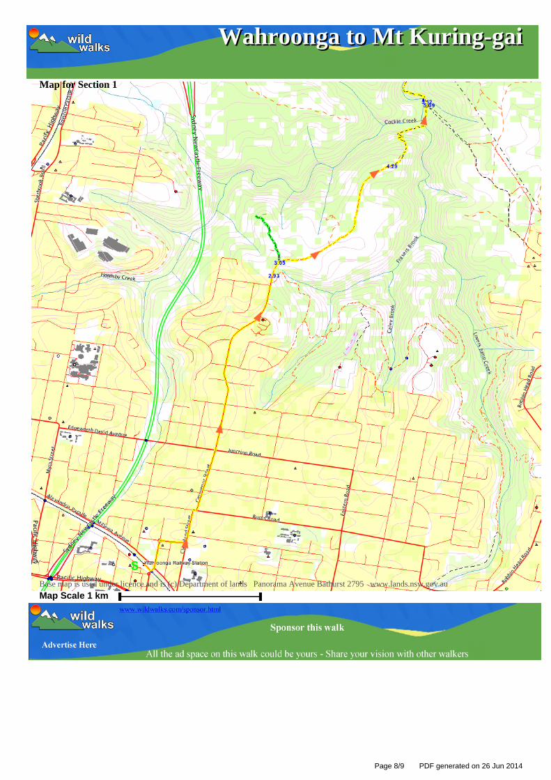
Map for Section 1
Base map is used under licence and is (c) Department of lands Panorama Avenue Bathurst 2795 www.lands.nsw.gov.au
Map Scale 1 km
Page 8/9 PDF generated on 26 Jun 2014

Wahroonga to Mt Kuring-gaiWahroonga to Mt Kuring-gai
Map for Section 2
Base map is used under licence and is (c) Department of lands Panorama Avenue Bathurst 2795 www.lands.nsw.gov.au
Map Scale 1 km
Page 9/9 PDF generated on 26 Jun 2014