wadi musa reclaimed water re-use pilot project · wadi musa reclaimed water re-use pilot project...
TRANSCRIPT

IALC Travel to Jordan 15 December, 2003 – 13 January, 2004 Wadi Musa Reclaimed Water Re-use Pilot Project Report submitted by Dr. Erin Addison
DRAFT REPORT

Table of Contents Section I: Summary of Activities 4 Section II: Continuity + Change 21 1. Introduction: conceptual theme 20 2. Design Rationale 20 3. The Building 21 4. The Landscape Design 23 Section III: Conceptual draft of landscape plan (to date) 24 Section IV: Project Timelines (drafts) 26 Timeline (a) 27 Proposed Landscape Design Timeline (b) 29 Appendix 1: Architect's "Scope of Work" 30 cover image: treated wastewater in the final separating tank, Wadi Musa Wastewater Treatment Plant,
Dec. 2003
2

List of Figures Page Figure 1 Ancient remains at Sidd al-Ahmar – probably a 5
Nabataean winery Figure 2 Provisional map of Sidd al-Ahmar 7 Figure 3 Reservoir (probably Nabataean) in Wadi al-Fidra 8 Figure 4 Terrace remains on Jabal Ba’aja – period undetermined 8 Figure 5 Small dam on Wadi Umm al-Heiran – period undetermined 9 Figure 6a Dam on Sidd al-Ahmar; silted, but in use 9 Figure 6b Old stone recently reinforced with concrete 9 Figure 7a Dam on Wadi Ba’aja 10 Figure 7b Silt load behind dam on Sidd al-Ahmar 10 Figure 8 Here we see at least four periods of 10
reconstruction on the Ba’aja dam Figure 9a Cattails downstream from the marsh area 12 Figure 9b Marsh area being creatged by watger released 12
from the ponds Figure 10a Proposed site for visitors’ center 14 Figure 10b Existing structure on proposed site 14 Figure 11 Rough sketches of the three design concepts 16 Figure 12a Examples of architecture local to Sidd al-Ahmar 17 Figure 12b Steps and tunnel (Sig Umm al-Heiran) 17 Figure 13 One possible siting for the amphitheatre 18
on the “picnic wadi” Figure 14 Jabal Ba’aja viewed from the demonstration farm 18 Figure 15a View of “picnic wadi” (Sidd al-Ahmar) from road 20 Figure 15b Example of picnic site to be developed 20 Figure 16 Conceptual design of landscape plan 25
submitted to BRDP Jan 18, 2004
3

Section I: Summary of Activities Wednesday morning I met with Muhandis Mohammad Shahbaz, Dr. Akrum Tamimi, Dr. Saad Al-Ayyash, and Dr. Ra'ed Tabini at the offices of the Higher Council of Research and Technology (HCST) in `Amman. We discussed in detail the timeline and activities for my visit and for the upcoming months during which the project will be implemented. We discussed the need for accurate maps and surveys. Saad and I went to the Royal Jordanian Geographic Society to look at and order maps of the Wadi Musa project site.1 This excursion took over two hours, due to the bureaucracy associated with procuring the maps. In the afternoon I met with Sahel al-Hiyari (of Al-Hiyari & Ghassous Architects), the proposed architect, to discuss the results of the morning's meeting and his offer. Met and had dinner with Akrum, Ra'ed and Dr. Ramzi Touchan of the University of Arizona. Thursday morning I spent working on the "Scope of Work" statement to submit to the architect. I went to HCST and set up office space – internet connection, printer, etc. – and then met with Muhandis Shahbaz2 to discuss my upcoming site visit. He briefed me on the previous afternoon's meeting with Dr. Amal Hijazi and Akrum. In light of that discussion we revised the timeline from the previous afternoon's meeting (see Section IVa. Project Timelines, below). I emailed the architect's "Scope of Work" to Shahbaz, Akrum, and Robert Freitas for comment. After picking up the maps, I returned to ACOR and met with ACOR Asst. Director Kurt Zamore, who has extensive experience composing budgets for interpretive projects,
1 There is a need to designate an appropriate name for this project, for use in future reporting and publications. Since the cooperative and the location are known locally as Sidd al-Ahmar, I am going to use that name in the present report. I would propose calling the project the Sidd al-Ahmar Visitors Center. It should be noted that while it is intuitive to assume, at first, that the name is Sadd al-Ahmar ("Red Dam"), we were later corrected on this point – the first word is Sidd, which is a dialect word for a small wadi. Thus the name of the farmer's cooperative and the local (`Amareen) name of the area means "Small Red Wadi". 2 With all due respect intended, once a person is introduced in the report by title and complete name I will refer them by their first names except for Muhandis Shahbaz, to whom I will refer as "Shahbaz" for the sake of clarity.
4
regarding the prices and kinds of signage available in Amman. I spent the balance of the afternoon in the ACOR map library in preparation for the upcoming site visit. At the end of the day I returned to HCST to pick up the revised "Scope of Work" from Shahbaz and to discuss his comments. (off) I discussed with Dr. Patricia Bikai (Co-Director, ACOR) the Little Petra archaeological area and hiking trails adjacent to Sidd al-Ahmar. Dr. Bikai is an archaeologist who has worked in the Petra area for two decades and lived in Jordan for the past 11 years, and she is deeply familiar with the area we are working in, as well as interpretive issues for cultural/ archaeological sites.
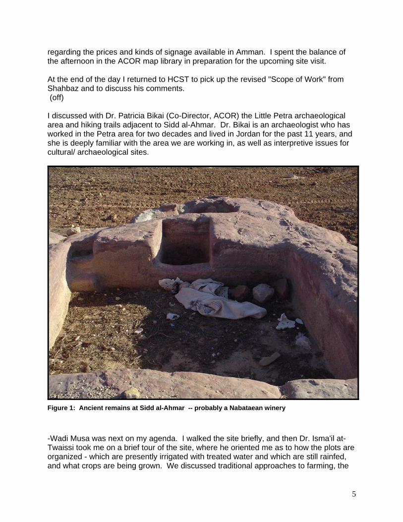
Figure 1: Ancient remains at Sidd al-Ahmar -- probably a Nabataean winery
-Wadi Musa was next on my agenda. I walked the site briefly, and then Dr. Isma'il at-Twaissi took me on a brief tour of the site, where he oriented me as to how the plots are organized - which are presently irrigated with treated water and which are still rainfed, and what crops are being grown. We discussed traditional approaches to farming, the
5

historical background of the various sub-groups of the `Amareen tribe, their migratory patterns with regard to the location of the site, and some of the background of the project and cooperative. We looked at some of the archaeological remains on the site, and planned to tour them all on Sunday. Dr. Isma'il shared with me some of his aerial photos of the Sidd al-Ahmar area. The rest of the afternoon and evening was spent working on the day's notes and the design concept/guidelines for the site. The present form of the design guidelines and concept can be found in Sections II & III, below. The next morning I continued working on field notes and prepared some sketches for discussion with Isma'il. I returned to the site. Dr. Isma'il and I took an extended tour of the site and the surrounding archaeological remains. We looked at two cisterns and a small reservoir with a filter on the demonstration farm plots, and two dams on the siqs running east-west in the cliffs to the east of the valley. There are plentiful small dams and water-control features along the other wadis. We also saw what they suspect is a winery (on the demo farm). We went farther north, into Wadi Fidra (on the road down into Wadi Araba), to see a larger, very impressive reservoir. On the way Isma'il pointed out the terraces on the northwest flank of Jabal Ba'aja. Figure 2 shows the location of this area. Figure 14 shows the conspicuous cone-shaped hill at the northeast edge of the valley. Most of the locals, including Dr. Isma'il, believe all of these material remains to be ancient, specifically Nabataean. Many of the locals simply say rumani, which literally means "Roman," but colloquially means "ancient" – not necessarily Roman. In fact, the remains will have to be examined more closely before they can be interpreted as Nabataean. This can be accomplished with a ceramics report and typological comparison with other water features. Prima facie they do not appear to be early Islamic. The large reservoir is probably Nabataean [Fig.3]. Many of the vernacular remains, however (e.g., the Jabal Ba'aja terraces [Fig. 4]), and the smaller dams [Fi. 5] may be much more recent. In regards to the dams – they have recently been refurbished, though there are older structural remains incorporated into them (Fig. 6, 7 [left]). I have seen three dams now3, and two of the three are almost entirely silted up (Fig. 7). I have begun inquiring why they are not used, and I will continue this line of inquiry.
3 I saw a third on my last site visit (see below, 11 January 2004).
6

Figure 2: Provisional map of Sidd al-Ahmar -- locations are approximate; map is based on RJGS JOR-5-A-Jpz-01-N/ Beidha (1998), and edited according to my field observations in Dec.'03-Jan.'04.
7
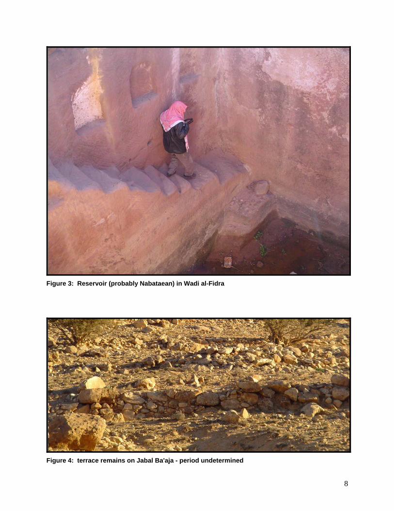
Figure 3: Reservoir (probably Nabataean) in Wadi al-Fidra
Figure 4: terrace remains on Jabal Ba'aja - period undetermined
8

Figure 5: small dam on Wadi Umm al-Heiran -- period undetermined
Figure 6a: Dam on Sidd al-Ahmar; silted, but in use
Figure 6b: Old stone recently reinforced with concrete
9
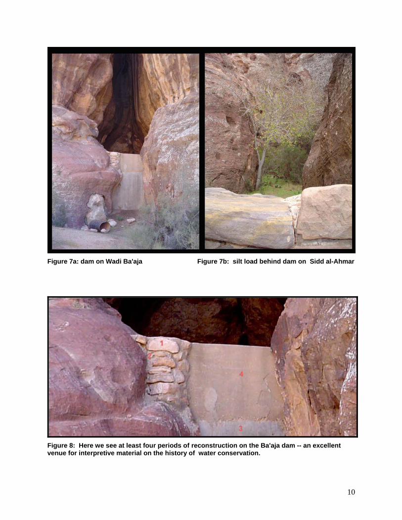
Figure 7a: dam on Wadi Ba'aja Figure 7b: silt load behind dam on Sidd al-Ahmar
Figure 8: Here we see at least four periods of reconstruction on the Ba'aja dam -- an excellent venue for interpretive material on the history of water conservation.
10
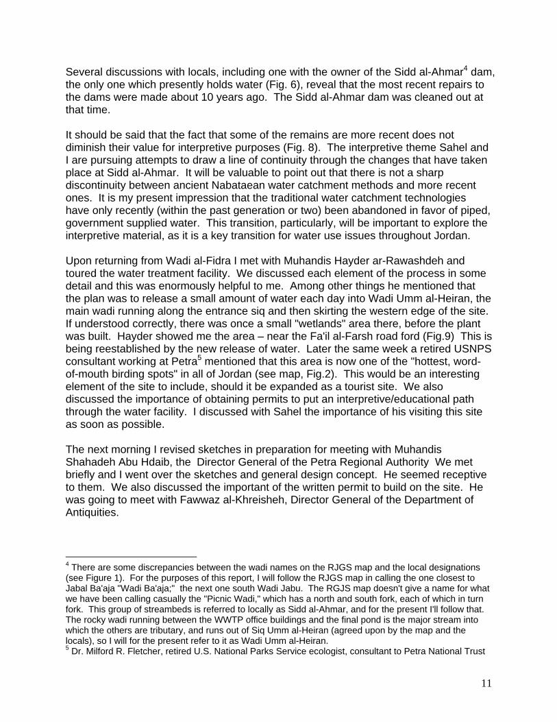
Several discussions with locals, including one with the owner of the Sidd al-Ahmar4 dam, the only one which presently holds water (Fig. 6), reveal that the most recent repairs to the dams were made about 10 years ago. The Sidd al-Ahmar dam was cleaned out at that time. It should be said that the fact that some of the remains are more recent does not diminish their value for interpretive purposes (Fig. 8). The interpretive theme Sahel and I are pursuing attempts to draw a line of continuity through the changes that have taken place at Sidd al-Ahmar. It will be valuable to point out that there is not a sharp discontinuity between ancient Nabataean water catchment methods and more recent ones. It is my present impression that the traditional water catchment technologies have only recently (within the past generation or two) been abandoned in favor of piped, government supplied water. This transition, particularly, will be important to explore the interpretive material, as it is a key transition for water use issues throughout Jordan. Upon returning from Wadi al-Fidra I met with Muhandis Hayder ar-Rawashdeh and toured the water treatment facility. We discussed each element of the process in some detail and this was enormously helpful to me. Among other things he mentioned that the plan was to release a small amount of water each day into Wadi Umm al-Heiran, the main wadi running along the entrance siq and then skirting the western edge of the site. If understood correctly, there was once a small "wetlands" area there, before the plant was built. Hayder showed me the area – near the Fa'il al-Farsh road ford (Fig.9) This is being reestablished by the new release of water. Later the same week a retired USNPS consultant working at Petra5 mentioned that this area is now one of the "hottest, word-of-mouth birding spots" in all of Jordan (see map, Fig.2). This would be an interesting element of the site to include, should it be expanded as a tourist site. We also discussed the importance of obtaining permits to put an interpretive/educational path through the water facility. I discussed with Sahel the importance of his visiting this site as soon as possible. The next morning I revised sketches in preparation for meeting with Muhandis Shahadeh Abu Hdaib, the Director General of the Petra Regional Authority We met briefly and I went over the sketches and general design concept. He seemed receptive to them. We also discussed the important of the written permit to build on the site. He was going to meet with Fawwaz al-Khreisheh, Director General of the Department of Antiquities.
4 There are some discrepancies between the wadi names on the RJGS map and the local designations (see Figure 1). For the purposes of this report, I will follow the RJGS map in calling the one closest to Jabal Ba'aja "Wadi Ba'aja;" the next one south Wadi Jabu. The RGJS map doesn't give a name for what we have been calling casually the "Picnic Wadi," which has a north and south fork, each of which in turn fork. This group of streambeds is referred to locally as Sidd al-Ahmar, and for the present I'll follow that. The rocky wadi running between the WWTP office buildings and the final pond is the major stream into which the others are tributary, and runs out of Siq Umm al-Heiran (agreed upon by the map and the locals), so I will for the present refer to it as Wadi Umm al-Heiran. 5 Dr. Milford R. Fletcher, retired U.S. National Parks Service ecologist, consultant to Petra National Trust
11
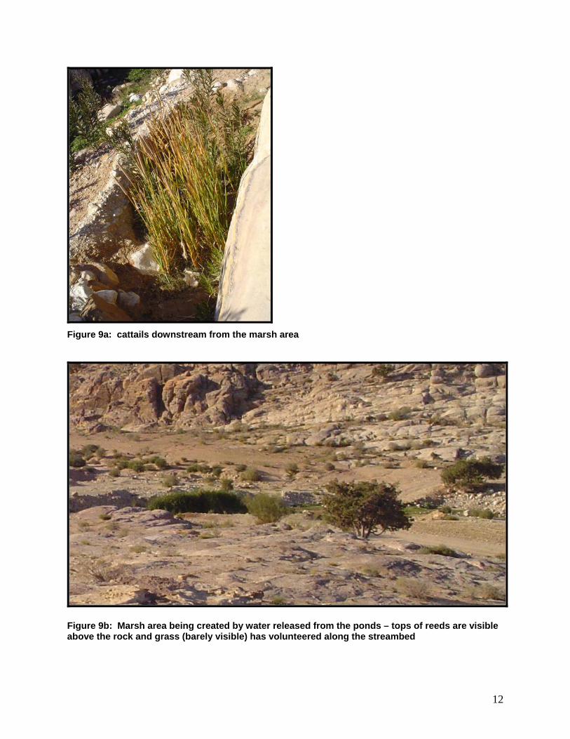
Figure 9a: cattails downstream from the marsh area
Figure 9b: Marsh area being created by water released from the ponds – tops of reeds are visible above the rock and grass (barely visible) has volunteered along the streambed
12

The next morning was spent revising the design guidelines for the site, based on the site visit. I went to HCST to email, plot the CAD map of the demonstration farm, and finish the revisions of the "Scope of Work" based on email feedback. I met with Shahbaz regarding the responsibilities of the various agencies and individuals as we move forward, and to set some concrete goals for the remainder of the time. I went over the "Scope of Work," budget, and tender process in detail with Shahbaz. I spent the rest of the morning and all afternoon, into the early evening at Al-Hiyari & Ghassous offices discussing design concepts, the nature of the integration/cooperation between landscape design and the design of the building, and then working through Sahel's offer with him. Visiting Wadi Musa Sahel and I left Amman early in the morning to drive to Wadi Musa. Once onsite Sahel immediately considered re-siting the visitors center to the north of the knoll at ground-level (Fig. 10). The rationale for this is multifold: -- the building would not disturb the ridgeline; -- we would gain all of the space on top of the knoll as an overlook platform; -- the building will face into the heart of the activities of the project – the farming; -- we could retain the existing structure on top of the knoll.6 -- we would not introduce a conspicuous intrusion into the initial view of the project, i.e., the farm and water treatment facility would continue to be the visual focus of the visitors first impression of the site. Sahel and I then hiked to both dams and back down the “picnic wadi” to consider the issue of signage, recreational clusters, and shade structures. After leaving the site we went to Wadi Musa to look at signage there. After that we visited Taybet Zaman to look at the treatment of shade structures and private/semi-public spaces. Return to Amman Shahbaz discussed with me design ideas and we worked through Dr. Fayez Tarawneh’s initial socio-anthropological report on the project. Later Sahel and I worked on his preliminary sketches. After the holidays Sa’ad, shahbaz and myself met to discuss goals for the week in preparation for a meeting on January 7th with BRDP, the architect, and myself. It was decided that preparing three conceptual design alternatives for the structure , the plan for the landscape design and preliminary cost estimates for the structure, landscaping and interpretive materials would be best. Later I worked with Hiyari & Ghassous Architects preparing design drafts, concept statements , and presentation for the January meeting with BRDP
13

Figure 10a: proposed site for visitors center, facing north approximately from the roadside
Figure 10b: Existing structure on proposed site
14
I worked at ACOR on the field notes for the previous day's site visit. Afterwards I discussed the design ideas with Shahbaz, and worked through Dr. Fayez Tarawneh's initial socio-anthropological report on the project. This report contains excellent material, the bulk of which has been confirmed by my experiences and discussions. Meeting with BRDP – January 7, 2004 In the early morning I prepared handouts and my presentation sketches for our meeting. Architects Sahel al-Hiyari and Rana Ghassous of Al-Hiyari & Ghassous Architects met with Shahbaz, Sa'ad, and me at HCST to discuss the designs for the visitors center structure and landscape. We went over the unifying design concept (see "Change + Continuity," Section II of this report). The architects presented three plans (Fig. 11) and details of the design rationale for each, which are included in the concept document ("Change + Continuity). I then presented a preliminary, hand-drawn draft of the landscape plan included in Section III, below, and a discussion of the rationale behind the design. The group unanimously preferred "Concept A," which excavates a cave into the existing rock knoll and then carving a stairwell which issues into the existing structure standing on top of the knoll. The whole front of the structure will be glass, looking out onto the demonstration farm. The interior of the structure would use sleek, modern finishes on the stone itself to express the continuity between the natural physiology of the site and the human use of it, and between ancient technologies and modern (Fig.12)). I met with Shahbaz to discuss the fact that we were going to need geological testing and reporting on the stability of the area before we could commit ourselves to Concept A. We also discussed what I might want to cover in my my last site visit. While we were talking one of the geologists from Markaz al-`Arabi (Arab Center) stopped in and we discussed the possibility of getting the testing accomplished before the meeting with USAID on January 20. Dr. Shatnawi, former Dean of the School of Agriculture at the University of Jordan, also stopped in and we discussed the research and surveys he has already done at Sidd al-Ahmar. We made some corrections to my site plan. Shahbaz introduced the possibility of extending the landscape design northward to include Jabal Ba'aja (Fig. 13), installing a trail to the top siting a vista point there, and adding in a small amphitheatre – perhaps in the "picnic wadi" (Fig. 14) These additions anticipate the possibility of extending the goal of the site to include international tourism.
15

Figure 11: Rough sketches of the three design concepts (these drawings are intended merely to give an impression of the three concepts -- they are my drawings, not Sahel's).
16

Figure 12: examples of architecture local to Sidd al-Ahmar and the Petra region in general, and which partially inspired the Concept A
Figure 12b: Design steps and tunnel (Sig. Umm al-Heiran) Nabataean vernacular dwelling (Beidha Road).
17

Figure 13: one possible siting for the amphitheatre on the "picnic wadi"
Figure 14: Jabal Ba'aja, viewed from the demonstration farm
18
It is worth commenting here that the latter extension of the concept no longer seems as far-fetched to me as it initially did. Given the dramatic natural context, the archaeological remains, the extent and interest of the proposed hiking trails, the excellence of Sahel's design proposals, and the possibility of birding tourism (important, for example, to RSCN's wetlands restoration project at `Azraq), as well as the proximity of the successful "`Amareen Bedouin Camp" tourist area at the intersection of the WMWWTP/ Beidha road – an international audience seems more plausible. I visited Jiza, Qastal & Mshash and Bayir to look at cisterns, wells and dams for the purposes of comparison to those at Sidd al-Ahmar. I met once more with Sahel to go over pictures he needed me to take on the last site visit, and to look at the refined sketches of the Concept A drawings. I returned to Sidd al-Ahmar to add detail to the existing site map and extend it north to include Jabal Ba'aja. I also wanted to discuss the "Concept A" design with as many people as possible and see what the reactions were. I was pleased that responses from literally everyone were all enthusiastically positive. I also wanted to reexamine the rock knoll which makes up the site of the visitor's center – its height and extent, and also its relationship to the final pond. Finally I drove up the Fa'il al-Farsh road to the ridge west of the site to take overall site photos and get a better general sense of the area. At Sidd al-Ahmar I spent time taking pictures of the picnic wadi (Fig. 15), looking for a site for the amphitheatre, correcting my earlier design, documenting the rock knoll and final pond,6 and confirming the location of the dams.
6 The fact that the final pond is itself sited within a cut into the rock knoll proposed for the visitors center suggests that the site is probably geologically stable.
19

Figure 15a: view of "picnic wadi" (Sidd al-Ahmar) from road
Figure 15b: Established, mature trees are an important attraction; example of picnic site (below), to be developed with table and firepit as well as some interpretive materials on the natural history of the wadi.
20

Section II: Continuity + Change Visitors Center & Landscape Design for the Wadi Musa Reclaimed Water Re-use Pilot Project Erin H. Addison, Ph.D.; Sahel al-Hiyari & Rana Goussous, Architects Introduction: Conceptual theme The building and landscape design for the Wadi Musa Reclaimed Water Re-use Pilot Project is themed around motifs of continuity and change: geographical, socio-cultural, technological and agricultural. Our premise is that the water treatment facility and farm cooperative emerge from a long tradition of water technology and agriculture in southwest Asia and in the Wadi Musa area in particular. All of the interpretive strategies – the structure, landscape design, images, and signage – elucidate the continuity of change, emphazing the fact that change and innovation emerge from history and tradition. 1. Purpose The building The building is intended to house an introductory interpretive display which orients any visitor to the site. In addition, it is intended to host small gatherings of people with shared interests in agriculture and water husbandry. The design of the building speaks of the continuity of culture in the valley that is to be interpreted: the remains of a vernacular structure are integrated into a modern building which serves as a conference venue and display space. Finally it serves as the axis for a network of interpretive paths into and beyond the demonstration farm. The landscape design The landscape design is structured in three zones or "tiers:" (1) the area immediately surrounding the building; (2) a network of pathways into the demonstration farm and water treatment facility; (3) a recreational/picnic area and an array of trails beyond the margins of the site. Each tier adds another layer of detail to the interpretation of the site. Pathways lead the visitor from the orientational material inside the building itself to the outside, first to view the site, then to walk into it. Additional interpretive material is located under shade structures which frame relevant views. At the outer edge of the network are clustered picnic sites. Trails extend beyond the network to selected historical remains (e.g. the Nabatean dams), geological formations and views. 2. Design Rationale The natural rock formations which surround and ground the site are the shaping force for a sensitive architectural and landscape design. The water treatment facility, the brilliant green of growing crops, the scored, linear surfaces of ploughed plots – all of these are conspicuous visual marks on the land. As the purpose of the building and landscape are to interpret the activities of farming and water re-use, it seems that the built interventions should be as subtle as possible: an unintrusive infrastructure which "reveals" and "frames" both the spectacular natural setting and the cultural processes at work on the site.
21

Each of the alternative concepts offered expresses a theme of continuity between modernity and tradition, culture and nature, the materials of technology and their sources in the natural world. In every case the built structure appears to emerge from the parent material, and traditional cultural forms speak to modernity. 3. The Building The purpose of the visitors' center is to facilitate the viewing of the site – to orient, focus, and frame what the visitor sees. With this in mind we have placed the building on the northern slope of the rock knoll at the center of the site, with entrance and parking off the side-road to Fa'il al-Farsh. The knoll thus serves as a viewing platform, where visitors will encounter an overview of the whole facility, and may choose to take one of the interpretive pathways deeper into the site. By siting the building on the slope, we avoid inserting an intrusive element against the existing skyline. At the same time the building gains the dramatic backdrop of the cliffs to the south of the valley. The northern entrance also faces into the center of the site, toward the heart of the site's activities. For all three designs it will be important to expose the knoll carefully and entirely, as the stone itself becomes part of the structure. We also propose to keep the small existing vernacular structure on the knoll. As it stands it blends well with the landscape and it also sustains a meaningful connection to the user community's past. It is an obvious visual statement of historical continuity which can be integrated into the modern structure. Concept (a) The structure is excavated from the bedrock itself, scripting on the traditional dwellings carved into stone throughout Wadi Musa. The resulting structure will expose beautifully finished stone surfaces and use the bedrock itself – polished and sealed – as a floor. Quarried stone from the excavation is used as material for walls and details. The design effectively minimizes volumetric intrusion into the landscape at the same time that it minimizes importation of materials from offsite. Concept (b) The primary integrating feature of the design is a wall which curves down the northeast slope of the knoll, connecting the existing vernacular structure with the new building. The wall employs traditional stone (like that of the existing structure) assembled with a more modern feel and finish, to form a line of visual continuity between the traditional and modern structure. The new building is set slightly away from the knoll, forming a courtyard space to the rear of the building. Openings are set into the east wall to frame specific views, underlining the four interpretive themes (geography, agriculture, water technology and socio-cultural history). The back courtyard connects the building spatially with the knoll as a viewing platform, and expresses the continuity between culture and nature.
22
Concept (c) Four stone walls emerge from the exposed rock surface of the knoll, like spokes from the hub of a wheel. Between the "spokes" is created a grid of indoor and outdoor spaces which communicate with each other and may be used for outdoor display areas as well. The walls which emerge from the natural bedrock convey the theme of connection and continuity between nature and culture, history and modernity, technology and parent material. 4. The Landscape Design In keeping with the aesthetic that guides the architectural design, the landscape design is minimal and unintrusive: it exists to guide the visitor through the history and activities that animate the site. The design does not introduce significant change in the existing landscape, but draws the visitor into physical interaction with the site and articulates it. As noted earlier, the landscape design is organized into three zones and three tiers of interpretation: Area (a) the visitors center; Area (b) the demonstration farm and water treatment facility; Area (c) the recreational clusters and surrounding landscape. Area (a) Finer points of the design for this area depend on the design chosen for the structure. The components of this design include the approach, entrance & parking, courtyards (if any), stairways onto the knoll and interpretive signage on the knoll. The existing road will be cobbled. Interpretive pathways run down both sides of the road, but are separated from the street itself by channels to harvest rainwater runoff. Entrance and parking (and courtyards, if any) will be designed to suit the building design. Stairways will either be cut into the stone or constructed of local stone to match the building design. On top of the knoll the four interpretive themes will be suggested by signage mounted low to the ground, directing the visitor's gaze toward an overlook at a point of interest. For example, the southern signpost will overlook the water treatment facility and identify the various elements and activities associated with the plant; the eastern signpost overlooks the demonstration farm plots and suggests points of interest regarding the crops under cultivation. These interpretive stations also direct the visitor's attention to pathways that lead further into the site (see Area b, below). Area (b) From Area (a), pathways lead the interested visitor into the next, more detailed tier of interpretation. In the example above, the visitor could descend from the knoll station down a pathway to a demonstration farm plot, where the next tier of interpretation would offer signage with a more detailed discussion of the crop, soils, fertilization, water needs, etc. Shade structures shelter interpretive signs (and visitors) and frame views of the material discussed on the signs.
23
Pathways are constructed of pavers or cobbles as appropriate to the venue. Between roadway and farm plot, for example, the paths are cobbled; within the water treatment facility they might be scored and dyed cement. Paths are discreetly bordered so as to direct the visitor clearly from one station to the next. The design of the shade structures will be determined by the choice of the building design. Area (c) Just to the north of the visitors center and demonstration plots is a rocky area unsuitable for cultivation, known as Wadi Sidd al-Ahmar. There are handsome existing trees there and striking views both of the surrounding landscape and the wadi itself. The locals have already taken to calling it "Picnic Wadi." We propose to place tables and benches, a few shade structures, and some trees at intermittent points along the wadi for recreational use. Each of these "recreational clusters" would also house interpretive material on the natural environment hosted by the wadi. Beyond the demonstration farm itself are several points of historical interest: Nabatean dams, a reservoir, cisterns, a wine press and terraces, some more recent vernacular structures and so on. To reach these sites requires only short walks through very attractive natural settings. The third tier of interpretive paths leads to these points of interest. These paths will not be paved at all. Indeed, as the paths lead farther and farther from the built environment of the visitors center and water treatment plant, the pathways are less and less constructed. The third tier of pathways will simply be bordered, and the only signage would be a discreet identifying plaque at the destination point itself, e.g., "Nabatean dam rehabilitated by the `Amareen tribe; used continuously since the first century B.C." Brochures available in the visitors’ center would provide a map and more interpretive detail. Section III. Conceptual draft of landscape plan (to date) The design board shown below (Fig. 16) was submitted to BRDP as part of the package present to the USAID Mission in `Amman on January 20th (along with the architect's concept drawings). This draft covers only the southern half of the site as it is currently being proposed – i.e., from the entrance north, up to and including Sidd al-Ahmar picnic area. The next step in the design process will be to expand the plan to include the northern part of the site, up to and including Jabal Ba'aja.
24

Figure 16: Conceptual design of landscape plan (to date), submitted to BRDP Jan. 18.
25

IV. Project Timelines (drafts) What follows is (a) a slightly revised version (see n. 7-8) of the timeline that was developed with BRDP in Dec.-Jan. The original timeline developed with Akrum and Shahbaz was revised several times based on incoming information, e.g., the Jan. 20 deadline at USAID. The timeline included here has no doubt been revised since I left Jordan, based on the need for geological testing of the knoll site, etc. Timeline (b) focuses on my involvement. Again, it is offered as a draft for discussion. Timeline (a) dates Erin Sahel Contractor BRDP PRA Contract/
construc-tion
USAID
7 Jan.
cost estimate
15 Jan.
first draft/ master plan
draft of building design concepts
provide final cost estimate
check & ok
30 Jan.
building & landscape plans approved
finalize drafts of building interior space, footprint on landscape
1-7 Feb.
tender structures/design
7-14 Feb.
offers
16 Feb.
decision
23 Feb
contract signed
copy
30 April
design tender document
copy
2-7 May
ok designs
9-13 May
bid & announce-ment
23 offers
26

May 30 May
choose contractor
1-7 June
prepare contractor
sign contract with security bonds (?)7
7 June- 15 Aug.
finish contract
financial contract with con-tractor
30 July
land prepara-tion plans for land-scape
15 Sept.
land scape & building installed7;
final report
10 Oct.- 31 Dec.8
develop inter-pretive materials/ displays
7 This line wasn't clear on the copy I have from BRDP. 8 There is an error here on the BRDP copy, as we agreed that the interpretive materials will occupy most of the fall and early winter.
27

(b) Proposed Landscape Design Timeline (draft for discussion) Feb. 1- March 11 -- library research, design development (Tucson) March 12 - April 2 -- finalize concept plan including northern half of site (`Amman) (Picnic Wadi > Jabal Ba'aja) -- map existing vegetation on Picnic Wadi -- determine amphitheatre site -- begin interviews with `Amareen individuals -- discuss site furniture design, signs -- continue photodocumentation of site -- collect plant specimens April 3-6 -- conference/ paper presentation at the 7th Annual Sharjah Urban Planning Symposium (Sharjah, UAE) April 2 – May 15 -- library research, design development (Tucson) May 15 – 28 -- (move from Tucson to California, California to `Amman) May 30 - June 2 -- WDM Conference, `Amman June 3 -- paper presentation at "The Fringe of Society: Archaeological and Ethnological Perspectives on Pastoral and Agricultural Societies" (Jerusalem) June 4-7 -- visit and document Israeli water treatment plants, holding ponds, headwaters of the Jordan river, Lake Tiberias (for Rome paper) June7 - June 30 -- prepare landscape plans with contractor (`Amman) July 1 – August 31 -- CSBE Architectural Laboratory (to fulfill UA (`Amman) studio requirement) August 31 – 15 Sept. (vacation) 15 Sept. – Dec. 31 -- research and design of interpretive materials, signs (`Amman) and displays*
28

* I will make one trip back to the U.S. during this time to meet with my committee at UofA and to attend the American Academy of Religion (AAR) annual conference meeting. If my abstract is accepted, I will be in Rome during the second week of October for the second "Israeli-Palestinian-International Conference on 'Water for Life' in the Middle East."
29

Appendix 1: Architect's "Scope of Work" This is a draft included for the record, although elements of the timeline have changed to accommodate research necessary for the building plans. Scope of Work for Architect Visitors' Center/ Wadi Musa Reclaimed Water Re-Use Pilot Project In general, the task is to design a 150m2 structure which will serve as a visitors' center for the Wadi Musa reclaimed water re-use pilot project and the demonstration farm associated with it. The site has already been determined. The structure is intended to be multipurpose: it will serve as a welcome center for visitors to the reclaimed water re-use facility and demonstration farm; it will host visiting groups of farmers and professionals interested in the use of reclaimed water; and it will serve as an interpretive center for the lay visitor and school groups, orienting the visitor to the site by offering basic interpretive material (e.g., maps, images, some textual interpretation and some audio-visual interpretation). It will also need to house the security staff person and serve as an office for the management staff person during regular business hours. The program for the design includes: (a) a meeting/ conference area; (b) surface space on walls for interpretive materials; (c) sufficient electrical infrastructure and a location with appropriate lighting for an interactive video screen; (d) quarters for the security guard; (this room should, ideally, be divided into two small rooms – a bedroom area and an anteroom with space for a small table and chair. The purpose of this is to create a private sleeping area that can be closed to public view, and a semi- private anteroom); (e) a small office/ reception area for the staff member who will manage the center during business hours; (f) a bathroom/lavatory; (g) a kitchenette; (h) storage space (some indoor and some outdoor); (i) bookshelves.
30
The design must conform to the codes and specifications of the Petra Regional Authority. The architect is expected to deliver work in three phases: (1) site analysis and initial design sufficient on which to base contractors' bids; (2) final plans and construction documents; (3) site visits and supervision to assure delivery of the designed structure. At each step deliverables will be approved by BRDP and the landscape architect. Timeline: Prior to December 25, 2003: architect will submit to BRDP a lump-sum budget for design work which includes site visits, design and supervision. January 7, 2004: architect offers at least two initial and cursory concept drafts for discussion; January 12, 2004: basic exterior style and materials agreed upon with the landscape architect; January 15, 2004: initial draft of the structure, sufficient to solicit bids from contractors, delivered to BRDP (Badia Research & Development Programme); (late January/ early February: advertisement and tender offers solicited by BRDP; accepted and approved by February 16); January 18, 2004: submit budget estimates for construction and interpretive materials; March 30, 2004: final construction documents deliverable to BRDP by the architect.
31