vol-ii land environment - sikenvis.nic.in environment.pdf · chapter 2 landslides 2.1 introduction...
TRANSCRIPT


PARTICIPATING INSTITUTIONS
• Centre for Inter-disciplinary Studies of Mountain & Hill Environment, University of Delhi, Delhi
• Centre for Atmospheric Sciences, Indian Institute of
Technology, Delhi
• Centre for Himalayan Studies, University of North Bengal, Distt. Darjeeling
• Department of Geography and Applied Geography, University
of North Bengal, Distt. Darjeeling
• Salim Ali Centre for Ornithology and Natural History, Anaikatti, Coimbatore
• Water and Power Consultancy Services (India) Ltd., Gurgaon,
Haryana
• Food Microbiology Laboratory, Department of Botany, Sikkim Government College, Gangtok

VOLUMES INDEX*
Volume – I INTRODUCTORY VOLUME
Volume – II LAND ENVIRONMENT - GEOPHYSICAL ENVIRONMENT
Volume – III LAND ENVIRONMENT - SOIL
Volume – IV WATER ENVIRONMENT
Volume – V AIR ENVIRONMENT
Volume – VI BIOLOGICAL ENVIRONMENT TERRESTRIAL AND AQUATIC RESOURCES
Volume – VII BIOLOGICAL ENVIRONMENT - FAUNAL ELEMENTS
Volume – VIII BIOLOGICAL ENVIRONMENT - FOOD RESOURCES
Volume – IX SOCIO-ECONOMIC ENVIRONMENT
Volume – X SOCIO-CULTURAL ENVIRONMENT
EXECUTIVE SUMMARY AND RECOMMENDATIONS *For Volume-wise Detailed Index – Refer to the end of the report

CONTENTS
Page No. CHAPTER 1 GEOLOGY AND SEISMICITY 1.1 GEOLOGICAL FRAMEWORK 1 1.1.1 Sub-Himalayan Domain 3 1.1.2 The Lesser Himalayan Domain 3 1.1.3 Higher Himalayan Domain 3 1.1.4 The Tethyan Belt 3 1.2 STRATIGRAPHY 4 1.3 STRUCTURE, TECTONICS AND METAMORPHISM 8 1.3.1 The Rangit Tectonic Window 10 1.3.2 The Main Central Thrust Zone 11 1.3.3 Movement along the structural planes 15 1.4 GEOMORPHOLOGY 17 1.5 MINERAL RESOURCES 17 1.5.1 Mineral and Rock Resources 19 1.6 SEISMICITY 31 1.6.1 Seismic Zoning 33 1.6.2 Isoseismal Zones 35 1.6.3 Recent Earthquake in Sikkim 36 1.6.4 Microearthquake Surveys 37 1.7 GEOLOGICAL INVESTIGATIONS IN TEESTA BASIN IN SIKKIM 39 1.7.1 Bop Nala Region 39 1.7.2 Chakung Chhu- Teesta Confluence Region 40 1.7.3 Ralang region within Rangit Window 41 1.7.4 Geology around Rolep in East Sikkim 43 1.7.5 Geology along Teesta between Tong to Mangan 44 1.7.6 Geology along Teesta between Mangan to Rangpo 45 1.8 SPATIAL DISPOSITION OF STUDIED REGIONS ON THE 47 SEISMOTECTONIC MAP OF SIKKIM 1.9 GEOLOGICAL SENSITIVITY AND VULNERABILITY 49

CHAPTER 2 LANDSLIDES 2.1 INTRODUCTION 52 2.2 STATUS OF LANDSLIDES IN TEESTA BASIN 54 2.3 SOME EXISTING LANDSLIDES IN SIKKIM 56 2.3.1 District-wise Scenario 58 2.4 CASE HISTORIES OF SOME IMPORTANT LANDSLIDES 66 2.4.1 The Rangpo-Dikling Landslide Complex 66 2.4.2 Chandmari- Tathangchen Landslide Complex 68 2.4.3 Landslide Complex in the region between Mangan to Tong 71 2.4.4 B2 Slide Complex along Gangtok-Dikchu Road 74 2.4.5 Rangpo Slide 74 2.4.6 Lukhbir and Berrik Slides in West Bengal 75 2.4.7 Landslides along the Lachung Axis 75 2.4.8 Landslides along Teesta upstream of Chungthang 76 2.5 ENVIRONMENTAL IMPACT OF THESE SLIDES 77 2.6 REMEDIAL MEASURES TO PREVENT LANDSLIDES 80 2.6.1 Keeping soil free of moisture 80 2.6.2 Increasing soil strength 82 2.6.3 Toe protection works 82 2.6.4 River Training 83 2.7 TYPICAL LANDSLIDE PROBLEM 84 2.7.1 Features 84 2.7.2 Mechanism 85 2.7.3 Treatment Measures 85 2.7.4 Variuos forces to be considered 86 2.8 FLOOD PROBLEM 91 2.9 SOCIO-ECONOMIC IMPLICATION OF FLOODS AND LAND
EROSION/SLIDES 93 2.9.1 Flood Management works in Vogue 93 2.9.2 Performance of Flood Management Works 95 2.9.3 Formulation and Implementation of Schemes 96 2.9.4 Evaluation of Flood Management Works 97

CHAPTER 3 GLACIERS 3.1 HIMALAYA AND GLACIERS 109 3.1.1 Glaciers 110 3.1.2 Glacial Movement 110 3.1.3 Glacial Erosion 112 3.1.4 Classification of Glaciers 113 3.2 RECESSION OF GLACIERS 114 3.3 GLACIAL STUDIES IN SIKKIM 116 3.4 OBJECTIVE OF THE STUDY 117 3.5 GLACIERS 117 3.6 GLACIAL LAKES 118 3.7 DATA USE AND METHODOLOGY 119 3.7.1 Topographic Maps 120 3.7.2 Satellite Images 120 3.8 INVENTORY OF GLACIERS 121 3.8.1 Area of the glacier 121 3.9 INVENTORY OF GLACIAL LAKES 123 3.9.1 Classification of lakes 124 3.9.2 Stability Analysis 125 3.9.3 Types of Glaciers 126 3.10 GLACIERS OF SIKKIM HIMALAYA 127 3.10.1 Zemu Glacier 131 3.10.2 Glacial Lakes of Sikkim Himalaya 132 3.10.3 Erosion lakes 133 3.10.4 Trough valley lakes 133 3.10.5 Cirque lakes 134 3.10.6 Blocked lakes 134 3.10.7 Supra-glacial lakes 134 3.10.8 Moraine-dammed lakes 135 3.10.9 Ice-dammed lakes 136 3.10.10 Inventory and Characteristics 136 3.11 MAJOR LAKES 139

3.11.1 Glacial Lakes Outburst Floods 141 3.11.2 Causes of Lakes Creation 142 3.11.3 Causes of Glacial Lakes Water Level Rise 143 3.11.4 Bursting Mechanisms 144 3.11.5 Mechanism of Ice Core-Dammed Lakes failure 144 3.11.6 Mechanisms of Moraine-Dammed Lakes failure 146 3.11.7 Surge Propagation 146 3.11.8 Sediment Processes during a Glacial Lakes Outburst Flood 147 3.11.9 Socio-economic effects of Glacial Lakes Outburst Floods 147 3.11.10 Potentially Dangerous Glacial Lakes 148 3.11.11 Criteria for Identification 149 3.11.12 Major Glacial Lakes Associated with the Glaciers 153 3.11.13 Potentially Dangerous Glacial Lakes 156 3.11.14 Glacial lake outburst flood mitigation measures, monitoring and early warning systems 158 3.11.15 Reducing the Volume of Lakes Water 158 3.11.16 Preventative Measures around the Lakes Area 159 3.11.17 Protecting infrastructure against the destructive forces of the surge 159 3.11.18 Monitoring and early warning systems 160 Bibliography 163 Annexure

LIST OF TABLES Table 1.1 Tectonostratigraphic Succession along South-North Darjeeling-Sikkim
Himalayan Section
Table 1.2 Mineral deposits in Sikkim
Table 1.3 Chronological Listing of some Earthquakes of Magnitude > 4.5 for Sikkim
Table 1.4 Seismic zones of India with corresponding MM (or MSK) scale intensity, Richter magnitude and horizontal force
Table 1.5 Effects of Bihar-Nepal Earthquake (1988) in Sikkim
Table 1.6 Focal Mechanism Solutions
Table 2.1 Some of the important landslides in different districts of Sikkim
Table 2.2 Landslides alongside the roads in Sikkim
Table 3.1 Database used for landuse/ landcover mapping of Teesta basin
Table 3.2 List of used topographic maps published by the Survey of India
Table 3.3 Glacier cover area inventory in Sikkim Himalaya
Table 3.4 Types of Glacier in the Sikkim Himalaya
Table 3.5 Number and area of glaciers in the Sikkim Himalaya as Published by the Geological Survey of India, 1999
Table 3.6 Types of glacial lakes in the Sikkim Himalaya
Table 3.7 Distribution of number and area with respect to the aspect of the lakes
Table 3.8 Major glacial lakes of Teesta basin in Sikkim
Table 3.9 Potentially dangerous glacial lakes requiring further studies and monitoring in different watersheds of Teesta basin in Sikkim

LIST OF FIGURES Figure.1.1 Geology and Stratigraphy of Teesta basin in Sikkim
Figure. 1.2 Geological section along A-B (see Fig. 1.1) in Sikkim Himalaya. MBT: Main Boundary Thrust, MCT: Main Central Thrust
Figure.1.3 Barrovian zones in MCT zone along SW-NE traverse
Figure. 1.4 Seismotectonic map of Sikkim and adjacent regions
Figure. 1.5 Seismic zoning map of India (Source : BIS, 2001, New Delhi)
Figure. 1.6 North-south depth section of earthquakes along P-Q traverse (Fig. 1.4) in Sikkim
Figure. 2.1 Old and new landslides in Sikkim Himalaya with locations of some of the important landslides.
Figure 2.2 Frequency of old and new landslides in various watersheds in Teesta Basin in Sikkim.
Figure. 2.3 Planimetric area of the watersheds (shown as bars) and the area covered by landslides (lines with dots) given in percent of the watershed area
Figure. 2.4 Geology around Rangpo-Dikling Landslide Complex
Figure. 2.5 Chandmari-Tathangchen Landslide Complex
Figure. 2.6 Geology of the area around Gangtok with location of Chandmari-Tathangchen Slide Complex and 9th mile side
Figure. 2.7 Geology around Mangan-Tong landslide complex
Figure. 2.8 B2 slides lies in the MCT zone
Figure. 2.9 Site plan of 7th mile slide on Gangtok-Kupup road
Figure. 3.1 Different bands of Landsat-7 (ETM+) December, 2000
Figure. 3.2 Bands 5,7 and 8 of Landsat-7 (ETM+) of December, 2000
Figure. 3.3 Subset of the satellite image of landsat-7 7 ETM+ Panchromatic mode of Dec. 2000 covering Teesta basin in Sikkim for the mapping of glaciers and glacial lakes.
Figure. 3.4 Subset and colour composite bands 9 (R) and 2(B) of Landsat-7 ETM+ of 26 Dec. 2000 to show the ice cover in the Zemu glacier
Figure. 3.5 Subset and colour composite bands 9 (R), 8(G) and 2(B) of Landsat-7 EYM+ of 26 Dec. 2000 to show the debris an clean glacier including the supraglacial lakes in gthe Zemu glacier.

Figure. 3.6 False colour composite (bands 4, 3 and 2 of the Landsat-7 ETC+) of Teesta river basin in Sikkim.
Figure. 3.7 Three-dimensional (3D) view, digital elevation model draped over the satellite image of Teesta basin in Sikkim.
Figure. 3.8 Subset and colour composite bands 9(R), 8(G) and 2(B) of Landsat-7 ETM+ of 26 December, 2000 of the Sikkim.
Figure. 3.9 Subset and colour composite bands 9(R), 8(G) and 2(B) of Landsat-7 ETM+ of 26 December, 2000 for the identification of glacial lake of the north-western part of the Sikkim.
Figure. 3.10 Subset and colour composite bands 9(R), 8(G) and 2(B) of Landsat-7 ETM+ of 26 December, 2000 for the identification of glacial lake in the Chhombo Chhu watershed of northeastern part of the Sikkim.
Figure. 3.11 Glaciers and lades of Sikkim Himalaya
Figure. 3.12 Satellite images showing the Zemu glaciers with different dates; a) November, 1989 Landsat-4 TM; b) November, 1990 IRS-1C LISS-II; c) December, 2000 Landsat ETM+ and d) November, 2002 IRS-1D LISS-III
Figure. 3.13 Three dimensional (3D) view of Zemu glacier in Sikkim Himalaya
Figure. 3.14 Subset and brand ratio image of Landsat-7 ETM+ of December, 2000 to show glacial lakes on Teesta basin in Sikkim
Figure. 3.15 Moraine dammed lake at the tow of the glaciers seen in the satellite image of Landsat-7 ETM+ in the colour composite of bands 4,3,2 (RGB) of December, 2000
Figure. 3.16 Moraine dammed lakes and erosion lakes in Chhombo Chhu watershed of Teesta Basin in Sikkim
Figure. 3.17 Trough valley lakes formed along the river valley in North Sikkim
Figure. 3.18 The blocked lakes formed adjacent to the glacier by blocking in North Sikkim
Figure. 3.19 Group of supraglacial lakes in moraine dammed lakes in association with the glaciers seen in Chanson glacier in North Sikkim.
Figure. 3.20 Example of a moraine dammed lake in association with the glacier in the north-western part of Teesta Basin in Sikkim (Landsat-7 ETM+ bands combination 9,8,2)
Figure. 3.21 The Khangchung Chho and Gurudongmar Chho lakes are the largest glacial lakes in the Chhombo Chhu watershed of Teesta Basin in Sikkim mapped from Landsat-7 ETM+ satellite image of 26 December, 2000
Figure. 3.22 Number and area (ha) of glacial lakes in different watersheds of Teesta Basin in Sikkim
Figure. 3.23 Distribution of glacial lake in various altitudinal zones in different watersheds of Teesta basin in Sikkim.
Figure. 3.24 Lake breach out markings in the lake boundary as well as in the river in image of Landsat-7 ETM+ of December, 2000
Figure. 3.25 Location and distribution of potentially dangerous glacial lakes in the Teesta Basin in Sikkim (For the details of numbers 1-18 see Table 3.9)

LIST OF PLATES
Plate 1.1 River terraces at the confluence of Teesta river and Chakung Chhu Plate 1.2 River terrace containing boulders and sand sized particles Plate 1.3 S-shaped folds on the limb of north plunging antiform Plate 1.4 Rhombohedral blocks separated out from the rock mass by plane failure
mode Plate 1.5 Channel bars on Teesta resulted due to blockage by sediments supplied
from tributary fans Plate 1.6 Fan lobe at the confluence of Papung Khola and Teesta river at Balutar Plate 1.7a Terrace T3 at Mangalbare with stream flow deposits Plate 1.7b Terrace T2 at Mangalbare with debris flow, hyperconcentrated flow and
stream flow deposits Plate 1.7c Terrace near Ralap village with hyperconcentrated and stream flow
deposits Plate 1.8 Destruction of forest by flood in the Singba Sanctuary Plate 1.9 Change in the course of Lanchung river in Singba Sanctuary due to
aggradation Plate 1.10 Collapse of Terrace on the left bank of Lachung and Creeping of
settlement on it Plate 2.1 Sherwani slide zone with active and old landslide scars Plate 2.2 Ghate Khola landslide cone Plate 2.3 Elaichi Khola sliding/ shooting boulder zone Plate 2.4 Singtel Sinking Zone Plate 2.5 Tintek Khola shooting boulder zone Plate 2.6 Manul – II Landslide Plate 2.7 Lanta Khola Landslide Plate 2.8 Myang Khola Landslide Plate 2.9 Water dashing at high velocity at Ri Chhu Landslide site Plate 2.10 Bar deposits in Teesta River at the confluence of Ri Chhu with large
boulders at its head Plate 2.11 Creeping and collapse of the protection wall near Ri Chhu

Plate 2.12 Collampse of old terrace and landslide cones at Tong
Plate 2.13 Mud flow at the base of the B2 landslide
Plate 2.14 B2 landslide
Plate 2.15 Rangpo landslide showing Rock fall and debris flow
Plate 2.16 Berrik landslide showing a fault propagated fold and the circular failure of carbonaceous phyllite
Plate 2.17 landslide upstream of Yumthang valley
Plate 2.18 Glacier tongue which supplies sediments into the Yumthang valley
Plate 2.19 Periglacial terrace deposits at the left bank of Lachung near Lachung
Plate 2.20 Erosion due to frost action upstream of Thangu at the left bank of Teesta
Plate 2.21 Landslide along with left bank of Teesta in Lachen axis
Plate 2.22 Collapse of old depositional landforms due to road building downstream of Thangu
Plate 2.23 Rock fall on the right bank of Rangpo Khola near Mangalbare
Plate 2.24 Relationship between road network, landslide and attitude of lithounits


Geophysical Environment – Geology and Seismicity
1
CISMHE
1.1 GEOLOGICAL FRAMEWORK
Since the work of Gansser (1964) in Darjeeling-Sikkim region,
most workers have divided the Himalaya into a series of longitudinal
tectonostratigraphic domains: i) Sub Himalaya, ii) Lesser Himalaya, iii)
Higher Himalaya, and iv) Tethys Himalaya (Neogi et al., 1998). These
domains are separated from each other by major dislocation zones.
Geology and geotectonics of Sikkim Himalaya have been studied
recently by various workers from different perspectives viz. i)
stratigraphy and structures (Ray, 1989; GSI, 2000), ii) metamorphism
(Dasgupta et al., 2004), iii) out-of-sequence thrust movement (Catlos et
al., 2004). Fig.1.1 shows details of lithology and structure of the region
and Fig.1.2 shows the geological section from Darjeeling Hill to northern
border of Sikkim along A-B marked on Fig.1.1. The core of the region is
occupied by the Lesser Himalayan low-grade metapelites (Daling Group,
Proterozoic to Mesozoic) and the distal parts by medium to high grade
crystalline rocks of the Higher Himalayan Belt (Higher Himalayan
Crystalline Complex, HHC, Proterozoic?). A prominent ductile shear
zone (the Main Central Thrust, MCT) separates the two belts. In this
region, the MCT is the southernmost of a number of northward-dipping
ductile shear zones within the Higher Himalayan Crystalline Complex.
Gondwana (Carboniferous-Permian) and molasse-type Siwalik
(Miocene-Pliocene) sedimentary rocks of the Sub-Himalayan Zone
occur in the southern part of the region. In the far north, a thick pile of

Geophysical Environment – Geology and Seismicity
2
CISMHE
Cambrian to Eocene fossiliferrous sediments of the Tethyan Zone
(Tethyan Sedimentary sequence) (see Fig.1.1) overlie the HHC on the
hanging wall side of a series of north-dipping normal faults constituting
the South Tibetan Detachment System (STDS; Burchfiel et al., 1992).
The HHC consists predominantly of high-grade pelitic migmatites
with subordinate calc-silicate rocks, metabasites and granites. The
pelitic migmatites are stromatic, with layer-parallel granitic leucosomes
and biotite rich melanosomes (Neogi et al., 1998). Patchy leucosomes
and discordant veins are also present. Banded, finely foliated augen
gneisses show transitions from stretched leucosomes to composite
crystal augens with porphyroblasts of K-feldspar. The augen gneisses
display pervasive mylonitic fabrics, suggesting that augen development
may reflect strain heterogeneities. Numerous layers of calc-silicate rocks
and minor quartzite occur throughout the HHC. Small bodies of
metabasic rocks are generally conformable to the gneissic and
migmatitic layering. Intrusive bodies of biotite and tourmaline
leucogranites, rarely exceeding a few tens of meters, occur in great
profusion in the upper parts of the HHC.
Sikkim Himalaya has been subdivided into distinct geotectonic
domains like other sectors, which are separated from one another by
thrust faults (e.g. Acharya and Shastry, 1979; Ray, 1976; Sinha Roy,
1982; Catlos et al., 2004; Dasgupta et al., 2004). They are described as
follows.


Geophysical Environment – Geology and Seismicity
3
CISMHE
1.1.1 Sub-Himalayan Domain
This domain lies in the south and consists of mollase type deposits
of the Siwaliks (Mio-Pliocene), and is separated from the lesser Himalayan
domain (LHD) in the north by the Main Boundary Thrust (MBT).
1.1.2 The Lesser Himalayan Domain
The LHD consists of a thin strip of Gondwana rocks
(Carboniferous-Permian), carbonate rocks (Buxa Formation) and a thick
metasedimentary sequence of dominantly pelites with subordinate
psammite and wacke (Daling Group). 1.1.3 Higher Himalayan Domain
The higher Himalayan domain (HHD) overlies the LHD and is
composed of medium to high-grade crystalline rocks, commonly referred
to as the higher Himalayan crystallines (HHC). These are dominantly of
pelitic composition, with sporadic quartzites, calc-silicate rocks,
metabasics and small bodies of granite. The HHC is separated from the
lesser Himalayas by the Main Central Thrust (MCT). The exact location
of this thrust has been controversial in many areas, including Sikkim (Lal
et al., 1981; Sinha Roy, 1982). 1.1.4 The Tethyan Belt A thick pile of fossiliferous Cambrian to Eocene sedimentary rocks
belonging to the Tethyan Belt (Tethyan Sedimentary Sequence) overlie

Geophysical Environment – Geology and Seismicity
4
CISMHE
the HHC on the hanging wall side of a series of north-dipping normal
faults constituting the South Tibetan Detachment System (STDS) in the
extreme north of Sikkim. 1.2 STRATIGRAPHY A comprehensive stratigraphic framework along a south-north
traverse from the foothills of Darjeeling-Himalaya to the northernmost
part of the Sikkim Himalaya is established by Ray (1989) and shown in
Table 1.1. The repetitive nature of the three units, namely the
Gorubathan, the Reyang and the Baxa of the Daling Group as also the
two units, the Rangit Pebble Slate and the Damuda of the Gondwana
Group, within a tectonic section has been shown from Darjeeling-Sikkim
Himalaya (see Table 1.1). Table 1.1 Tectonostratigraphic Succession along South-North Darjeeling-Sikkim Himalayan Section (after Ray, 1989, GSI, 2000)
North
TETHYAN GROUP 4. Tso Lhamo Formation
3. Lachi Formation
2. Mt. Everest Limestone
1. Mt. Everest Pelitic Formation
_________________ TRANS AXIAL THRUST _________________
SIKKIM GROUP Darjeeling Gneiss, Khangchendzonga
Gneiss and Chungthang (=Paro) Subgroup

Geophysical Environment – Geology and Seismicity
5
CISMHE
with Lachen Leucogranite (and its
Equivalents)
___________SIKKIM (MAIN CENTRAL?) THRUST______________
DALING GROUP Gorubathan Subgroup
(with Lingtse Granite Sheets at different
Structural Levels)
(Syngenetic Fe-Cu-Pb-Zn Mineralisation)
____________ KALET CHHU-LEGSHIP THRUST ______________
DALING GROUP
Reyang Subgroup
Buxa Subgroup Gondwana Group
Gorubathan Subgroup
___________________ PAJOK THRUST _____________________
A Zone of pile of thin scales of
Daling Group (Gorubathan-Reyang-Buxa Subgroups)
and Gondwana Group (Rangit Pebble Slate -
Damuda Formations)
_____________ NORTH TATAPANI THRUST__________________
GONDWANA GROUP 2. Damuda Formation
1. Rangit Pebble Slate
DALING GROUP 3. Buxa Subgroup
2. Reyang Subgroup
1. Gorubathan Subgroup
_______________NAYA BAZAR THRUST_____________________
A Zone of Pile of thin Scales of
Daling Group (Gorubathan-Reyang-Baxa Subgroups)
Geophysical Environment – Geology and Seismicity
6
CISMHE
and Gondwana Group (Rangit Pebble Slate -
Damuda Formations)
___________ KITAM-MANPUR KHOLA THRUST_______________
DALING GROUP 2. Reyang Subgroup
1. Gorubathan Subgroup
________________ SIM JHORA THRUST_____________________
DALING GROUP Gorubathan Subgroup
(With Lingtse Granite Sheets)
_ NORTH DARJEELING (BARNESBERG-BADAMTAM) THRUST __
SIKKIM GROUP Chungthang Subgroup, Darjeeling Gneiss,
Khangchendzonga Gneiss (? Middle
Cenozoic Pegmatite Aplite Formation and
small Granite Bodies)
___________SOUTH DARJEELING THRUST __________________
DALING GROUP Gorubathan Subgroup
(Intruded, Metasomatically Replaced and
Technically Emplaced Lingtse Granite)
(Syngenetic Fe-Cu-Pb-Zn Mineralisation)
__________DEORALI-RONGCHONGTHRUST _________________
DALING GROUP 2. Reyang Subgroup
(with slices of Gorubathan Subgroup)
1. Gorubathan Subgroup
(with slices of Rangit Pebble Slate and
Damuda Formation in Basal Portion)
_________________ DALING THRUST ______________________
GONDWANA GROUP 2. Damuda Formation

Geophysical Environment – Geology and Seismicity
7
CISMHE
1. Rangit Pebble Slate
(Slices of Daling Group)
_______________ TINDHARIA THRUST______________________
GONDWANA GROUP Damuda Formation
________ MAIN BOUNDARY THRUST (SOLE OF NAPPE)_______
SIWALIK GROUP 2. Geabdat Formation
1. Chunabhatti Formation
(Intermixed with Damuda Slices in Rangtong Thrust)
___________ RANGTONG (IMBRICATE) THRUST _____________
SIWALIK GROUP 3. Murti Boulder Bed
2. Parbu Grit
1. Geabdat Formation
______________ UNCONFORMITY/FAULT ___________________
QUATERNARY GROUP Alluvium
Terrace Boulder Beds
SOUTH
Further work has been carried out towards the north of MCT (GSI,
Gangtok, 2000). The regional geologic map presented in Fig.1.1 is a
compilation of observations contained in the works of Ray (1989),
Acharya (1989), Neogi et al. (1998) and GSI, Gangtok (2000). In this
figure excepting the unclassified region, pelitic migmatite (stromatic,
patchy) and minor interbanded pelitic schist and metabasites of HHC
(see Neogi et al., 1998), the rocks in the area covered by the political
boundary of Sikkim towards the north of Main Central Thrust (MCT) are

Geophysical Environment – Geology and Seismicity
8
CISMHE
grouped into: Chungthang Formation, Biotite-Muscovite Gneiss,
Darjeeling Gneiss, Khangchendzonga Augen Gneiss, Everest
Limestone, Lachi Formation and Tso Lhamo Formation (See Fig. 1.1).
Also observed in this region are isolated patches of tourmaline granite
and calc-silicate rocks with interbanded quartzite. 1.3 STRUCTURE, TECTONICS AND METAMORPHISM
A number of discrete linear zones of ductile deformation (DDZ) are
seen in many localities. The DDZ cut across lithological boundaries and the planar fabric S2 commonly seen in the gneissic layering that is
defined by the alignment of biotite and silimanite grains (Neogi et al.,
1998). These zones are narrow, characterised by intense mylonitization,
formed late in the deformation history, and are associated with mineral
lineations and stretching lineations. The stretching lineations generally
plunge to the north. Shear sense indicators consistently indicate a top-
to-south sense of movement. S-C fabrics associated with the top-to-
south transport are found within the gneisses in these zones (Neogi et
al., 1998).
The MCT is generally regarded as a major intracrustal ductile
thrust zone (Grujik et al., 1996). The MCT is few kilometers wide. In
some parts of the Himalayan orogen, the upper bounding fault of the
MCT zone marks a metamorphic discontinuity (Hodges and Silverberg,
1988; Metcalf, 1993), whereas in other parts no such break is
recognized (Hubbard, 1989). In the Sikkim region of NE India, the Main

Geophysical Environment – Geology and Seismicity
9
CISMHE
Central Thrust (MCT) juxtaposes high-grade gneisses of the High
Himalayan Crystalline, the Darjeeling series, over lower-grade slates,
phyllites and schists of the Lesser Himalaya, the Daling Series (Catlos et
al., 2002). Inverted metamorphism characterises rocks that underlie the
MCT, and is described in the Sikkim region as a gradual increase in
metamorphic intensity in the Daling series at lower topographic levels to
the Darjeeling series at higher levels with no apparent break across the
fault (e.g. Mallet, 1875; Ray, 1947). Because both increasing (Metcalf,
1993) and decreasing (Thakur, 1986; Lombardo et al., 1993) grades of
metamorphism towards higher structural levels have been observed the
geological picture in the Higher Himalayas is rather confusing (Neogi et
al., 1998). Numerous models have been proposed to account for the
observed inverse metamorphic zonation in the Himalayas and a
prominent role is assigned to the MCT in most of these models. The
pressure gradient of 0.25 kbar/ km resembles a normal lithostatic
gradient, which suggests that the HHC in Sikkim represents an inverted
Barrovian sequence. This inverted zonation of the HHC is probably the
result of large-scale structural inversion and/or tectonic juxtaposition
because of ductile shearing (Neogi et al., 1998).
The Darjeeling rocks are largely gently N-dipping, but locally
domed to fold west, east and north (Hooker, 1854). Structurally above
these is the contact between the Darjeeling and Tethyan rocks, which in
Sikkim has been reported from two places (Edwards et al., 2002,
locations 1 and 2 in see Fig.1.1). In NW Sikkim on Jonsang Kang
(~7000m – location 1 in see Fig.1.1) the northward dipping orthogranitic
Geophysical Environment – Geology and Seismicity
10
CISMHE
Khangchendzonga gneisses (part of the Darjeeling series) are
structurally in contact with limestones (Dyhrenfurth, 1931). From the
Lachi Spur (location 2, see Fig. 1.1), Wager (1934) observed that the
Permian Lachi series and a small sliver of the underlying Mt. Everest
limestone are in 45°N dipping normal fault contact with “porphyroblastic
feldspar” biotite gneiss (Wager, 1939). This appears to be the first
accurate identification of the South Tibet Detachment System (STDS)
(Catlos et al., 2002). The STDS and the trace of the Himalaya are
monoclinally bent across the Chhumbi graben valley (the southern most
part of the N-S Yadong-Gulu rift system) stepping north by ~40km to the
east of this point (the Yadong Cross Structure) (Edwards et al., 2002).
The Dalings occupy large area of Teesta valley and form a dome
below the Darjeeling gneiss. The Lingtse-granitoid gneiss occurs within
the Daling Group of rocks. The contact between the Lingtse Granitoids
with Dalings is controversial. The arcuate shape of the MCT in Sikkim is
in conformity with the domal structure of the Higher Himalayan
Crystalline. The MCT passes about 5 kms east of Gangtok and crosses
the Teesta River near Manul. The E-W trending north dipping MBT
crosses the Teesta river near Kalijhora township.
1.3.1 The Rangit Tectonic Window
The Daling Group of rocks was earlier considered as older than
the Buxa Group. Later on Srikantia (1977) comparing the regional
settings suggested that the Daling could be equivalent of the Simla and

Geophysical Environment – Geology and Seismicity
11
CISMHE
Jaunsar Groups are probably younger than the Buxa. This suggests that
Daling resting along a thrust over the Buxa in the Rangit Valley is a
superficial nappe.
The lowermost structural belt in the Rangit Valley is the
Precambrian Buxa Group with overlying Upper Carboniferous-Lower
Permian Rangit Pebble Formation. The Buxa-Rangit Pebble on all side
is framed by the Daling Thrust Sheet (see Fig. 1.2). Geology of the
Rangit Window is summarised below.
Window Rangit Valley
Thrust Sheet Daling
Superficial nappe
Thrust Sheet rocks Dalings
Trace of Thrust Dalings
Window Rocks Rangit Pebble, Buxa
- - - - - - - - - - - - - - - Unconformity - - - - - - - - - - - - - - - - - - - - - -
1.3.2 The Main Central Thrust Zone
The deformation zone related to the MCT is often referred to as
the Main Central Thrust Zone (MCTZ). Over the entire length of the
Himalayas, the inverted Barrovian sequence is contained essentially
within the MCTZ. The metamorphic facies distribution follows a pattern
that is likely to have been controlled by tectonic development,
particularly by the major dislocation zones such as the MCT which
appears to be a deep crustal feature. The zonal boundaries are folded

Geophysical Environment – Geology and Seismicity
12
CISMHE
by NE-SW and NW-SE regional folds in the western Himalaya, and
dominantly by N-S and E-W regional folds in the eastern Himalaya
(Sinha Roy and Bhargava, 1989).
Himalayan metamorphism is essentially Barrovian with minor
contact metamorphic signatures around major plutons. The foothill belt
of the Siwaliks, and the Murrees are nonmetamorphic in character. The
rocks of the Lesser Himalayan paraautochthonous belt, namely, the
Gondwanas in the Eastern Himalaya and the Krol-Tal-Subathu
sequences in the Western Himalaya, both of the frontal belt as well as of
the Window zones (Eastern Himalaya), are either anchimetamorphic or
in the lower greenschist facies. In the Eastern Himalaya the greenschist
facies assemblages, represented by the Daling sequence, is delimited in
the north by dislocation zone (MCT-I of Sinha Roy, 1988 � MCT of
Catlos et al., 2004) at the base of the tectonised slivers of the Lingtse
Gneiss and in the south by a thrust (MCT-II of Sinha Roy, 1988 � MCT
of Catlos et al., 2004) at the contact of the Gondwana rocks (Fig. 1.3). At
the lowest structural level of the Daling thrust sheet near MCT-II in the
Sikkim Window zone, moderate-pressure and low-temperature
metamorphism characterized by transitional glaucophanitic actinolite in
metagraywacke has been reported by Sinha Roy (1975, 1977b). This
metamorphism is considered to be due to thrusting deformation in low-
temperature lower greenschist facies domain.
A sequence of all the Barrovian metamorphic zones along an SW-
NE traverse (Fig. 1.3) is present within a short distance around Rongli
Region (Sinha Roy and Bhargava, 1989; Dasgupta et al., 2004). In this

Geophysical Environment – Geology and Seismicity
13
CISMHE
region, metamorphism progressed in an easterly direction from chloritic,
micaceous phyllite and quartzite to different varieties of micaschist,
culminating in the appearance of migmatitic pelites. A dominant
eastward dipping pervasive planar structure indicates that the whole
section is an inverted metamorphic sequence. A well-foliated
granodioritic augen gneiss, locally named as Lingtse Gneiss, is exposed
in the middle of the sequence.
The MCTZ in the Rongli area is identified as a large-scale high-
strain zone of disturbed deformation, as can be determined on the basis
of detailed meso- and micro-structural analysis (Neogi et al., 1998;
Dasgupta et al., 2004). This criterion of the MCTZ in the Sikkim
Himalaya is similar to that proposed by Pecher (1989) in Nepal, Grujic et
al. (1996) in Bhutan and Stephenson et al. (2000) from Zanskar. The
MCTZ has variable exposed thickness in Sikkim, and along an E-W
transect in Rongli is ca. 12 km wide, involving both the so-called lesser
and higher Himalayan rocks, and extending from the biotite zone to
beyond the muscovite-out isograd (Fig. 1.3). Rocks below the MCTZ are
referred to as the LHD and those above it as the HHD.
Along an E-W cross-section Dasgupta et al. (2004) recognized three groups of major planar fabrics S1, S2 and S3. The S1 is an incipient
fabric, which is parallel to the compositional layering in the lesser
Himalayas, and is commonly preserved as an included fabric in the porphyroblastic phases in the MCTZ. The S2 is the most pervasive
planar fabric in all domains, being a slaty cleavage in the chlorite and
biotite zones, a schistosity in the garnet to sillimanite-muscovite zones

Geophysical Environment – Geology and Seismicity
14
CISMHE
and a gneissosity in the sillimanite + K-feldspar zone. The orientation of
this planar fabric along the transect is roughly the same throughout, that is below, within and above MCTZ. The S3 represents a crenulation
cleavage or schistosity on S2. In the higher grade rocks, S3 is
represented by a mylonitic foliation. Also, the metamorphic isograds are roughly parallel to the S2 planar structures with the higher grade rocks
appearing progressively northwards, eastwards, and westwards of what
is known as the Teesta Dome. These observations suggest that a
regional deformation folded the metamorphic isograds with
approximately a northerly plunge.
In the Rongli location the determined kinematic shear sense is top
to SW, whereas along the Teesta transect, it is top to S or SSW. The
horse-shoe or mushroom shaped pattern of the Darjeeling-Sikkim
region, which is attributed to the Teesta culmination zone, is due to the
interference of E-W and N-S folds (Ray, 2000). Whereas the northerly
plunging antiformal structures can be found in Sikkim, the E-W
synformal structures are exposed in the Kalimpong and Darjeeling
areas. The huge area of the Teesta culmination has exposed a vast
expanse of the lesser Himalayan units in the core.
A qualitative model of sequential emplacement of thrust sheets
progressively toward the south in Himalaya, and sequential
metamorphism of the rocks under the increased overburden of the thrust
has been proposed after detailed structural mapping in Nepal,
(Robinson et al., 2003). This model proposes that the overburden
decreases southward due to the gradual climb of the basal Himalayan

Fig.1.3 Barrovian zones in MCT zone along SW-NE

Geophysical Environment – Geology and Seismicity
15
CISMHE
decollement in this direction and erosional denudation of the rocks. This
model is also able to produce a close relationship between metamorphic
crystallization and a dominant fabric and increase of both pressure and
temperature in the up-section direction (Dasgupta et al., 2004). 1.3.3 Movement along the structural planes
The high Himalayan mountains are the result of collision of India
with Asia that began ca. 60 million years ago (e.g. Le Fort, 1975; Yin &
Harrison, 2000). High rates of seismicity and deformation are the
characters of the range at present (Yeats et al., 1992). Widespread
exposure of post-collisonal, high-grade metamorphic rocks in the
Himalaya implies long-term, large-scale vertical transport (Catlos et al.,
2004). The MCT has generally been regarded as an early Miocene
structure (e.g. Hodges et al., 1996; Vannay and Hodges, 1996).
However recent observations (e.g. Harrison et al., 1997a; Catlos et al.,
2001, 2002a) have suggested that the rocks within broad MCTZ
experienced metamorphism later than Miocene. For instance, the Th-Pb
dating (Catlos et al., 2001) of small (c.15 micro m sized) monazite from
rocks within the crystallized MCT shear zone in central Nepal yields
ages as young as c.3 Ma.
It has also been thought that with the shift in deformation from
Indus-Tsangpo suture towards foreland (e.g. the evolutionary model of
Seeber and Gornitz, 1983) the MCT was formed subsequent to Late
Cretaceous-Early Eocene Indo-Asia collision (e.g. Le Fort, 1975; Yin
and Harrison, 2000). Although contraction appears to have broadly

Geophysical Environment – Geology and Seismicity
16
CISMHE
progressed towards the Himalayan foreland as activity shifted from the
MCT during the Early Miocene (e.g. Hodges et al., 1996) to the Main
Boundary Thrust (MBT) during the Late Miocene (e.g. Meigs et al.,
1995), to the currently active Main Frontal Thrust (MFT, e.g. Yeats et al.,
1992), monazite ages from the Lesser Himalaya in central Nepal and
NW India (Harrison et al., 1997a; Catlos et al., 2001, 2002a) indicate
that the hinterland thickened internally during the Late Miocene and
Pliocene (Catlos et al., 2004). However, the post-Early Miocene MCT
movement may be restricted to certain regions viz. central Nepal
(Harrison et al., 1997a; Catlos et al., 2001), eastern Nepal and NW India
(Catlos et al., 2002a). Thus, the generality of the out-of-sequence
thickening along the strike of the Himalayan range remains unknown.
The temporarily distinct monazite ages from MCTZ and STDS in
Sikkim suggest that the MCT was active at 22-20, 15-14 and 12-10 Ma,
whereas the STDS may have been active at c.17 and 15-14 Ma
supporting out-of-sequence thrusting in the region (Catlos et al., 2004).
However the study of Dasgupta et al., (2004) reveals three key points: a)
there is progressive increase of both temperature and pressure with
increasing grade and structural height through the MCTZ and the lower
part of the HHC, b) the growth of metamorphic minerals at all grades is closely related temporally to one dominant fabric, S2, and c) there is
nothing out-of-sequence in the Rongli section, in terms of not only
increasing P and T, but also key mineral parageneses.
Geophysical Environment – Geology and Seismicity
17
CISMHE
1.4 GEOMORPHOLOGY
The Teesta river originating in, and fed by the glaciers of the
northernmost tracts of the Sikkim Himalaya, has formed an important
river basin in the Eastern Himalaya. The Teesta valley is characterised
by glacial and periglacial landforms in north and north-central Sikkim
and by abundant fluvial terraces in the lower stretches. The geomorphic
features observed in the region includes the terraces all along the
courses of the higher order streams. Four-tier terrace system is
observed in the central and lower stretches of the Teesta river in Sikkim-
Darjeeling Himalaya. Their development is linked with regional uplifts
and consequent incision and their dispositional irregularities with local
tectonics and knick-points (Sinha Roy, 1980). Numerous active
landslides are also present along the right and left banks of the major
rivers in north, south, east and west districts of Sikkim. The glacial
moraines predominates in the upper reaches of the Teesta river.
Besides these features, alluvial fans and cones are present at several
places in the basin.
1.5 MINERAL RESOURCES
The Geological map so far prepared by GSI serves as the base for
mineral exploration and assessment of reserve in the state of Sikkim. It
may be noted here that the completed geological mapping of Sikkim
(area 7,325 km2) by GSI does not cover the permafrost region (> 5,000
m) covering an area of 1,138 km2 which mostly fall in the North Sikkim.
Important Syngenetic Fe-Cu-Pb-Zn sulphide-oxide mineralized horizons

Geophysical Environment – Geology and Seismicity
18
CISMHE
occur in the Daling Group in Sikkim (see Table 1.1). Some of the
important mineral deposits are listed in Table 1.2.
Table 1.2 Mineral deposits in Sikkim
Deposits Locality
Copper ores Western Sikkim: Changbong, Jugdum,
Raothak, Sumbuk,
Northern Sikkim: Dik Chhu
Iron Ore Bhotang
Lead-Zinc Rangpo, Dik Chhu and Jugdum
Dolomite Ranguthang, Chinchi and Salebong
Limestone Rinchingpong, Chhangu
Marble Chungthang
Coal Rangit valley: Rebong, Namchi and Rinchinpong
hill, Put Khola, Roathak Khola, Baiguno Khola,
Andhari Khola, Ranji Khola and Namrek Khola
Graphite Bot village near Chungthang, Derhati, Kalijhar,
Kuapani and north of the road from Tathing and
Lachen
Garnet Panchikhani (in small quantity)
The mineral deposits need to be evaluated not in terms of their
importance as ‘resource availability’ and ‘uses in industry’ supporting the
carrying capacity of the region but in terms of a) wastes likely to be
Geophysical Environment – Geology and Seismicity
19
CISMHE
resulted due to their exploitation, b) their chemical and physical effects
on the land and water environments. Therefore, a detailed account of
mineral and rock resources present in Sikkim (GSI, 2001) and their
industrial usability is given below.
1.5.1 Mineral and Rock Resources
1.5.1.1 North Sikkim The North Sikkim is situated in the rugged, inaccessible, high
altitude region of the Himalaya. So far exploration programmes by GSI
have been able to locate the calc-silicate/marble deposits in the north
district of Sikkim and there is every likelihood that other deposits may be
present in this district in substantial quantity.
i) Calc-Silicate/Marble
Calc-silicate/Marble bands occur within the high-grade gneissic
sequence of Central Crystalline. There are three main occurrences of
calc-silicate/marble rocks:
a) NE and NW of Chungthang. This deposit is situated mainly in
the form of boulders at about 5.5 km NW of Chungthang on
Chungthang-Lachen road. It has a length of about 300 m along
the road up to the point where the highway crosses the
Chubinbin Chhu.
b) The second deposit is located about 13.3 km NW of
Chungthang-Lachen road and 700 m south of Tarum Chhu

Geophysical Environment – Geology and Seismicity
20
CISMHE
cutting across the highway. It has a length of about 450 m
along the road and is represented by thinly interbanded calc-
silicate, quartzite associated with calc-granulite and crystalline
marble.
c) The third one is present near Malten Shiva temple, 6 km NE of
Chungthang on the Chungthang-Lachen road. The deposit
occurs in association with high-grade schist and gneiss and
covers a stretch of about 50 m only along the vicinity of the
Shiva temple. Other minor occurrences of calc-silicate/ marble
are present along Singhik-Chungthang road near Myang village
and near police check post at Tong. In many localities the
carbonate being leached out in solution from the calc-silicate
bodies and redeposited on the surface of quartzite, giving them
a deceptive look by typical surfacial elephant skin weathering.
ii) Building Stone The area comprises a variety of gneisses, some of which are
compact and massive (weakly foliated varieties) and can be used as
building stones. A few of these rocks could also find use as decorative
slabs with suitable cutting and polishing. But the remoteness of such
occurrences makes them non-viable for decorative and building stone
industry.
1.5.1.2 South Sikkim
Several metallic and non-metallic mineral deposits are present in
the South district of which the dolomite and coal are most important.

Geophysical Environment – Geology and Seismicity
21
CISMHE
Sporadic occurrences of sulphide mineralisation have also been located
in several parts of the district. Basemetal occurrences have been
recorded in the Daling Group of rocks, dolomite within Buxas and coal in
the Gondwana rocks.
iii) Dolomite
Dolomite occurring in this district are of two types :
a) The high grade massive type The high grade massive dolomite occurs most extensively in
the Rangit river valley region. Good quality dolomite belonging
to the Buxa Formation are present near Rishi Khola at 27o,15’
N; 88o,18’ E. The dolomite is light grey in colour and fine
grained in nature with high percentage of CaO and low
insoluble content (insoluble 1.5-3%). A reserve of 1.10 million
tonnes has been estimated by GSI down to a depth of 30 m
from the surface. These dolomites are of both ‘Blast Furnace’
(less than 3% insoluble) and ‘Steel Melting shop’ (< 1.5%
insoluble) grade.
b) Low-grade flaggy type The low grade siliceous and flaggy dolomite occurs associated
with Gondwana rocks between Namchi and Phong and
between Namchi and Jorethang. Grey dolomite deposit occurs
at Phalidanda, Tangji and Chamgaon areas near Namchi. The

Geophysical Environment – Geology and Seismicity
22
CISMHE
impure dolomite is suitable for crushing into powdery form for
spreading on the cultivable lands for neutralization purpose.
c) Coal Coal bearing horizons are exposed in and around Namchi
(27o10’N; 88o24’E) area of South Sikkim. The total estimated
reserve in this area is 1.4 lakh tonnes of coal. This is a
bituminous to semi-anthracitic variety of coal, occasionally
pulverized due to intensive folding and shearing movement. On
analysis, this variety of coal indicates 40-60% fixed carbon, 22-
40% ash, 3-8% V.M. and 3-6% moisture. This coal can be used
for local consumption after proper benefaction and blending
with the high volatile bituminous coal. This bands of coal are
exposed near Jorethang on Jorethang-Namchi road section
near Sikkip. Coal seams are also exposed in Namchi-Tinjir road
section and in the areas on eastern slopes of the Rangit River
along Rishi-Sagbari section. Due to tectonically disturbed
nature it is very difficult to trace the continuity of the seams.
Borehole data reveal that the coal seams are in association
with band of clay stone, sandwiched between sandstone-shale
sequences. The coal is normally overlain immediately by a
carbonaceous shale and/or siltstone unit containing plant fossil
fragments and is underlain by the carbonaceous shale unit. The
quality of coal has deteriorated due to intense deformation,
crushing and intimate mixing with associated sandstone and
shale.

Geophysical Environment – Geology and Seismicity
23
CISMHE
d) Sulphide Mineralisation Stringers and disseminations of sulphide mineralisation in the
form of chalcopyrite and pyrite occur sporadically within the
phyllitic rocks of Daling Group in several localities of the district
such as Damthang, Khani Khola, Subbuk, Pamphuk and Temi.
In the bed of Khani Khola, a tributary of Manpur Khola,
chalcopyrite and pyrite mineralization with few specks of galena
is present. Analytical data reveals that sulphide mineralisation
is rich in copper and contains traces of lead, zinc and silver.
The mineralized zone is traceable in an old adit, located on the
eastern bank of Khani Khola for about 30 m along strike. The
sulphide-bearing horizon is associated with quartz vein and is
found to be emplaced within the quartz-chlorite-sericite schist of
Daling Group of rocks along the regional foliation plane. The
host rock is trending E-W and has moderate dip towards north.
1.5.1.3 East Sikkim
The two producing Cu-Pb-Zn mines of Sikkim are located at
Bhotang, Ramp and at Rorathang in the East Sikkim. Small occurrences
of base metal prospects in East Sikkim had been known since long.
Sizeable heaps of slags are found at several places like Pachekhani,
Bhotangkhani, Tukkhani and Rattukhani.
Sikkim Mining Corporation is exploiting the polymetallic deposit at
Rangpo and Rorathang. The prime mineralisation at Rangpo consists of
chalcopyrite, pyrite, pyrrhotite and the total sulphide is less than 2%.

Geophysical Environment – Geology and Seismicity
24
CISMHE
Associated country rocks are chlorite-phyllite, garnetiferous chlorite
schist/sericite phyllite, quartzite and carbon phyllite. A total reserve of
0.6 m.t. of polymetallic ore at 1% cut off was estimated by IBM, most of
which has already been mined out. Occurrences of sulphide
mineralisation and an associated magnetite quartzite horizon around
Kalej Khola (northwest of Rangpo), Andheri Khola (northeast of Rangpo)
have also been reported. In Pachekhani-Rorathang block, sulphide
mineralisation occurs as disseminations in gritty-quartz-biotite-phyllites,
slaty carbonaceous phyllites and calcareous quartzites besides some
post-tectonic hydrothermal quartz veins. At upper Pachekhani block, a
total of 60,940 tonnes of copper ore of average grade 1.26% Cu has
been estimated. In Dugalakha block, mineralisation mostly of galena and
chalcopyrite are concentrated generally in hydrothermal vein quartz and
rarely as disseminations.
Other significant base metal deposit, known as Dikchu Copper
Zinc deposit, is situated at the confluence of the Dik Chhu and the
Teesta River. Garnetiferous-muscovite-biotite schist is the main host
rock in this zone. The sulphide mineralisation is chalcopyrite, pyrite,
pyrrhotite, sphalerite and galena with magnetite as major oxide mineral.
In Rungdu-Sodunglakha and Kerabari area falling in Pakyong and
Rongli Sub-divisions of East Sikkim the copper mineralisation is
associated with quartz-biotite-chlorite-chloritoid schist. Mineralisation is
structurally controlled (?), concentrated at the closure of Rangpo Chhu
antiform. This block may prove to be of economic importance.

Geophysical Environment – Geology and Seismicity
25
CISMHE
1.5.1.4 West Sikkim This district has great potential in terms of mineral resources and
mineral based industries. The district has appreciable deposits of
dolomite and limestone in a relatively undisturbed situation. There is
scope for development of building stone/ polished shale (gneiss, marble,
quartzite) industry, ceramics (clay horizons).
The major non-metallic mineral reported from west Sikkim are
dolomite and graphite. Minor occurrences of soapstone or talc,
magnesite and asbestos etc. have also been recorded but all, except
talc, are till now of uneconomic quantity. Occurrences of sulphide
mineralisation have been located in Chakum, Soreng, Chongbong,
Roathak, Bum and Legship.
i) Dolomite
Both high-grade massive and low-grade flaggy type dolomites
have been located in Rishi area, in the southeastern part of
the district, west of Jorthang-Legship state highway. On either
banks of Rishi Khola, adjacent to Rishi village (27o 13’ N; 88o
46’ E), four dolomite-bearing blocks have been delineated.
Massive dolomites are light grey in colour, fine grained with
high percentages of MgO (18-22%), CaO (ca. 30%) and
insoluble (1.5-3 %). A total reserve of more than one million
tonnes has been estimated down to a depth of 30 m.

Geophysical Environment – Geology and Seismicity
26
CISMHE
ii) Graphite
Graphite both lumpy and flaky types, associated with graphite
schist, marble and limonitised pegmatite of High Grade
Gneiss, has been located at Chitre (27o16’20"N : 88o02’10"E)
and Dareli (27o17’N: 88o03’E) of West Sikkim. The graphite
bands occur even at depths of 2 to 3 m below the surface and
the thickness varies from 30-80 cm. An estimated reserve of
about 6,000 tonnes of graphite has been computed from
Chitre sector. The IBM has conducted beneficiation test on
this graphite, which indicated good liberation of graphite in
finer fraction. However, impersistent and pocketry nature of
graphite occurrences, their inaccessibility and location at high
altitude (3,000-4,000 m) near India-Nepal border, have
rendered these occurrences uneconomic in view of the high
cost of exploration, mining and transportation of the materials. iii) Coal Thin coal seams occurring within the carbonaceous shale-
sandstone sequence of Gondwana Group have been located
around Put Khola, Roathak Khola and Rinchingpong area of
the district. The coal is black to grayish black in colour,
powdery in nature, semi-anthracitic with high ash, low volatile
matter and high (?) moisture. iv) Asbestos
Near Tashiding, bluish grey short matted, harsh fibre type of
asbestos associated with acicular tremolite and actinolite
crystals have been located within the Dalling Phyllites.

Geophysical Environment – Geology and Seismicity
27
CISMHE
v) Limestone
Grey limestone interbanded with green phyllites is observed in
Rishi Khola, south of Namgaon. An exposure of limestone,
about 30 m thick is traceable over a strike length of 60 m near
Rishi Khola. It contains CaO (42-46%), MgO (1.22-2.20%) and
insoluble (12-14%). Pink limestone with shales is exposed at
Nayabazar. Limestone is massive, hard and breaks with
conchoidal to semi-conchoidal fracture. Selected portion of
limestone horizon have 42-44% CaO, 1.22-1.6 % MgO and
11- 18% insoluble.
vi) Talc
Talc occurrences have been located in Rani Khola, Rishi
Khola, and Roathak Khola within the metamorphic rocks of
Daling Group. Talc is found as pockets within the phyllite and
is intimately associated with an inrtrusive quartz vein in Rani
Khola area.
vii) Magnesite
In the metasediments and metabasics of Rangit valley,
magnesite occurrences have also been located.
viii) Rock Phosphate
Occurrences of rock phosphate in stromatolitic dolomite near
Tatapani and Subuk area within the Daling Group have been
reported in the eastern part of the district. The phosphate-
bearing horizon are very thin and impersistent in nature.

Geophysical Environment – Geology and Seismicity
28
CISMHE
ix) Sillimanite
Sillimanite along with kyanite occurs either as needles or as
fibrous aggregates within the quartz cummingtonite-quartz
schists forming a part of high-grade biotite gneiss. A few
sillimanite enriched zones were located between Sardung and
Dentam villages. The most promising occurrence is at
Sardung area, which has a thickness of 50m and strike length
of 250m prospected by trenching and sampling. Chemical analysis of five samples show very low Al2O3 (5-15 %)
content. Therefore, this silimanite deposit does not seem to be
of economic importance.
x) Quartzite
Occurrences of quartzite within the Daling Group of rocks has
been reported from Mansari-Malbashe-Chakung and
Bardang-Singrep-Jhum-Roathak areas. Extensive exposures
of pure white/milky white massive and flaggy variety of
quartzite at Mansari has some economic potential.
xi) Sulphide Mineralisation
Base metal occurrences containing chalcopyrite with pyrite, in
the form of veins, stringers and disseminations have been
located at Jugdum, Roathok, Sisni, Sirbong, Sontali,
Chugbung, Legship and Bum.
a) Jugdum (27o11’ N : 88o14’48" E): The copper mineralisation is
associated with quartz veins and occurs within the thick

Geophysical Environment – Geology and Seismicity
29
CISMHE
greenish chlorite phyllite of Daling Group over a length of 215
m. A few lenses of chlorite schist and phyllite containing
mineralized quartz vein also occur in this area. There are
three main mineralized quartz veins in the main zone. Copper
mineralisation present between the vertical depths of 49 m
and 57 m. Copper content of core sample was between 0.21 –
0.64%. At Jugdum, the Daling phyllites and schists have a
NNE-SSW regional strike with foliation dipping towards WNW.
b) Roathak Khani (27o09’50" N : 88o15’18" E): The Roathak
Khani occurrence is located at the confluence of Khani Khola
and Roathak Khola and is about 1.6 km NE of Chakung
village. Sulphide mineralisation containing chalcopyrite and
pyrite is noted over a length of about 500 m on the right bank
of Khani Khola. The copper mineralisation is mainly
associated with quartz veins and slates of Daling Group.
c) Sisni (27o15’N : 88o14’23" E): Sisni deposit is located about 90
m upstream of the Sisni Khola from its confluence with
Roathak Khola and about 2 km NW of Chakung village. The
copper mineralisation with 0.15 to 0.35% Cu is associated
with quartz veins in Daling slates. The main band has a
thickness ranging from 0.8 m to about 2 m over an exposed
length of about 44 m.

Geophysical Environment – Geology and Seismicity
30
CISMHE
d) Shribong (27o 10’20" N : 88o 16’E): Chalcopyrite and pyrite is
exposed in quartz veins associated with slaty phyllite of Daling
Group. The quartz veins have widths ranging from 0.61 m to
1.83 m and are exposed on the bed of Shribong Khola, 1.6 km
NNE of Roathak Khani.
e) Sontali: Copper mineralisation noticed in association with
quartz veins within the sericitic phyllites, slates and chlorite
schists of Daling Group. Three mineralized quartz veins were
identified with widths ranging from 0.3 m to 0.6 m.
f) Chongbong (27o7’30" N : 88o15’ E): Chongbong occurrence is
located on the southern slope of Chakung ridge at an
elevation of about 900 m on steep scarp face and the left side
of Chongbong Khola. Poorly mineralized quartz veins with
total width of 1.3m occur within the slaty phyllite striking NE
and dipping NW.
g) Legship (27o17’ N : 88o17’ E): In Legship area the basemetal
mineralisation is observed in the northern bank of Bania nala,
near its confluence with Rangit River. Sulphide minerals viz.
pyrite, pyrrhotite, chalcopyrite, bornite and galena occur as
disseminations and thin hairline fracture filling in quartz veins.
The copper content ranges from 1200 ppm to <100 ppm.

Geophysical Environment – Geology and Seismicity
31
CISMHE
h) Bum (27o13’ N : 88o15’ E): The mineral occurrences are
observed both in phyllite and quartzite and are exposed on
either banks of Rishi Khola near the Bum bridge. Pyrite,
chalcopyrite, bornite, galena and pyrrhotite are seen in
association with vein quartz stringers, varying in thickness
from less than 1cm to 13cm. Sample from a 115 cm thick
quartz vein from this area has yielded 3.41-4.50% copper, but
it does not show persistent strike.
At present quartzite and talc are being mined from Mansari in
West Sikkim. Previously dolomite was being mined from Rishi by private
agencies. They used to crush the dolomite into powder and sale to the
State Government of Sikkim for distribution to the farmers for spreading
on cultivated lands for neutralizing the acidic soil. Only Dolomite may
have some future potential for use in steel industry.
1.6 SEISMICITY
A detailed account on the seismotectonic environment of the
Sikkim and its adjoining region is given in the recent syntheses of Narula
et al. (2000) and Kayal (2001). Like other parts of the Himalaya, this
area is also traversed by MCT and MBT (Fig. 1.4). The former separates
the high grade Central Crystallines from the comparatively lower grade
Lesser Himalayan packages, which are separated from the Siwalik belt
by the MBT. At places, particularly towards east, several subsidiary
thrusts are present between MCT and MBT. Besides these thrusts,

Geophysical Environment – Geology and Seismicity
32
CISMHE
several approximately N-S trending gravity faults are present particularly
within the northern Tethyan belt and the southern Foothill belt (see
pages 13-14 Narula et al., 2000). Within the Tethyan belt these N-S
faults define some well known graben structures such as Pum Qu
Graben and Yadong Gulu Graben. In the former, faults affecting the
Quarternary glacial deposit are clearly evident. The latter graben is
considered to be the longest one in the Tibetan Plateau. It is segmented
into several N-S smaller grabens. The Rangpur Ridge is a prominent
tectonic feature in the east which is bound on all sides by major faults,
namely Malda-Kishanganj Fault, Jangipur-Gaibandha fault, Teesta fault
and Katihar-Nailphamari fault. Several subsidiary faults, parallel to
Teesta fault forming grabens are reported from this ridge (Narula et al.,
2000). Many northeasterly and northwesterly trending lineaments also
cut across the Himalayan belt in this region. Some of them are : i) the
Arun Lineament (NE-SW) believed to represent the northern
extension of the East Patna Fault, ii) the Khangchendzonga Lineament
(NW-SW) extends from the foredeep to well inside the Himalayan belt,
iii) Teesta Lineament (NW-SE), and iv) Purnia-Everest Lineament (NW-
SE).
The spatial distribution of seismic activity in the region during the
period 1964-1992 suggests that the regional seismicity of Sikkim
Himalaya is relatively high to the north of the Main Boundary Thrust
(MBT) and the activity decreases progressively southward from the
Lesser Himalaya to the foredeep region, under sediment cover (Nath et


Geophysical Environment – Geology and Seismicity
33
CISMHE
al., 2000). The central main Himalayan block with considerable
seismicity separates the northern Tethyan block and southern foredeep
block with subdued seismic activity (Narula et al., 2000). In this area
most of the earthquakes are shallow focus (< 40 km) and are commonly
of 4.5-5.5 magnitude range (Table 1.3). Table 1.3 Chronological listing of some earthquakes of magnitude
>4.5 for Sikkim (after Narula et al., 2000) Sl. Yr Mo Dt Hr Min Sec Lat Long Ms Mb Depth (km)
1. 1964 08 30 02 35 07.3 27.36 88.21 - 5.1 21
2. 1972 08 21 14 04 33.9 27.33 88.01 - 4.5 33
3. 1972 08 21 18 55 07.2 27.23 88.02 - 5.1 33
4. 1975 01 23 01 37 42.9 27.44 88.37 - 4.5 33
5. 1979 11 16 19 17 27.7 27.90 88.70 - 4.6 39
6. 1980 11 19 19 00 45.0 27.40 88.80 6.1 6.0 47
7. 1982 04 05 02 19 41.2 27.38 88.83 4.6 5.0 09
8. 1982 08 18 18 01 07.6 27.04 89.26 - 4.6 51
9. 1985 05 25 00 28 18.7 27.60 88.48 - 4.6 33
10. 1986 01 07 20 20 00.4 27.40 88.43 - 4.7 41
11. 1988 05 26 16 30 05.5 27.45 88.61 - 4.7 42
12. 1988 09 27 19 10 10.0 27.19 88.37 4.6 5.0 23
Source: International Seismological Centre (ISC) 1.6.1 Seismic Zoning
The revised Seismic zoning map of India (BIS:2000),
encompasses four zones namely II, III, IV and V (Fig. 1.5). The Modified

Geophysical Environment – Geology and Seismicity
34
CISMHE
Mercalli (MSK) scale intensity and horizontal force corresponding with
seismic map zones of India are shown in Table 1.4. The area covered
by Sikkim falls in zone-IV (see Fig. 1.5). The seismic zoning maps only
serve as guide maps, and therefore, detailed study of any
developmental site and its surrounding areas is essential to take safety
measures against any future devastating tremors.
Sikkim region lies within the ambit of the Seismic Zone-IV of I.S.
code 1893-1984/1998/2000. With reference to the MSK intensity scale
used for all engineering design purposes the region lies in the high
damages risk zone (VIII) corresponding to a magnitude of 6.7 in the
Richter scale. Therefore, there is always a necessity to consider the
factor of safety for highest earthquake intensity while designing an
engineering construction.
Table 1.4 Seismic zones of India with corresponding MM (or MSK)
scale intensity, Richter magnitude and horizontal force
Seismic MM Richter Horizontal Zones of Hazard Intensity (or MSK) Magnitude Force Coef. India Intensity
II Low Damage Risk Zone VI or less 5.2 0.02
III Moderate Damage Risk Zone VII 6.0 0.04
IV High Damage Risk Zone VIII 6.7 0.05
V Very High Damage Zone IX and above �7.4 0.08
Force (H) = Coefficient of Horizontal force as fraction of building weight


Geophysical Environment – Geology and Seismicity
35
CISMHE
1.6.2 Isoseismal Zones Temporal variation of seismicity in the area shows that there is
burst of earthquake for a year or two preceded by a quiet period of 3 to 4
years (Nath et al., 2000). The Bihar-Nepal earthquake of 1988 was
distinctly felt in Sikkim. According to National Earthquake Information
Centre, USGS report this earthquake of 20th August, 1988 occurred at
23:09:09.5 PM. The magnitude (Ms) was estimated to be 6.6. The
epicenter was located at lat: 26.76º N and long: 86.62º E and the
hypocentral depth estimated as 57km. The damages in the 3 distinct
isoseismal zones (shown in Fig. 1.4) are outlined in the Table 1.5. The
isoseismal VII passes through Gangtok town, in an approximately NE-
SW direction (see Fig. 1.4). Several buildings in Gangtok were badly
damaged and the death toll went up to 1003.
Table 1.5 Effects of Bihar-Nepal earthquake (1988) in Sikkim Isoseismal Damage Zone
VIII Pass through Phulbazar and Chakum in a NNE-SSW direction. A
triangular area west of this isoseismal VIII up to Nepal border
experienced severe ground shaking where damages in buildings
were extensive.
VII South of Gangtok it passes in an approximate NE-SW direction.
North of Gangtok it has a northerly trend up to Lachen. The impact
of damages on power generation units, road alignments were

Geophysical Environment – Geology and Seismicity
36
CISMHE
mainly in the form of subsidence and landslides. The masonary
walls of the buildings cracked and at places resulted in complete
collapse.
VI Lachung (1400 m a.s.l.) lie in this area. The area experienced
strong vibration of the ground resulting in general damage to
houses, subsidence of grounds and incipient cracks in the
buildings. The ground movement was of shaking type and people
reported to have felt tossing type of shock.
(Source: Sinha, 1993) 1.6.3 Recent Earthquake in Sikkim An earthquake measuring 5.3 on the Richter scale jolted the
region of Sikkim and adjacent states on 14th Feb, 2006 at 00 hr 55 min
26 sec (UTC) (6:25:25 AM local time). The epicentral region was located
around Meekha between Peling and Rabangla at 27.3547 N latitude and
88.3552 E longitude with location uncertainity (±5.2 km) (USGS, 2006).
This was a shallow focus earthquake the focal deptgh being 30.3 km.
The tremor was felt at Siliguri, Sikkim, Darjeeling, Guwahati,
Itanagar, Jalpaiguri, Kooch Bihar, Karsiyang, Maldah, Shilong. It was
also felt at i) Paro Chhu, Phuntsholing and Thimpu of Bhutan, ii)
Dinapur, Naokhali Khad, Nilpahmari, Pabna, Rajshahi, Rangpur, Sylhet
and Thakurgaon of Bangladesh, iii) Kathmandu in Nepal. About 60% of
the houses got cracks in Gangtok and Rangpo. Cracks on roads
observed at places. Water supply and telecommunication networks were
Geophysical Environment – Geology and Seismicity
37
CISMHE
disrupted. Two people killed by landslide at Sherathang and two were
injured in East Sikkim.
1.6.4 Microearthquake Surveys
Detailed microearthquake surveys were carried out in the
Darjeeling Himalaya (De, 1996) and in the Sikkim Himalaya (De, 2000).
Kayal (2001) has provided a detailed interpretation of these studies. It is
observed that the earthquakes are mostly clustered to the north of MBT,
at a depth range of 10-40 km and majority of the earthquakes occurred
below the plane of detachment (see Figs 1.4 and 1.6). A well-
constrained composite fault-plane solution for a group of earthquakes
(depth 10-40 km) shows thrust faulting with strike-slip component (see
Fig.1.6). The north dipping E-W nodal plane is comparable with the
MBT, and is the preferred fault-plane (De, 2000). The depth section and
the fault plane solution suggest that the MBT is seismogenic up to the
mantle in this part of the Himalaya; i.e. the MBT is a mantle reaching
active fault (see Fig.1.6). Based on the gravity data, Choudhury and
Dutta (1975) interpreted that the MBT is a mantle reaching thrust zone in
the eastern Himalaya. Thus the microearthquake data as well as the
gravity data do not support the steady state or evolutionary tectonic
model in the eastern Himalaya, which postulates that the MBT
converges at the plane of detachment and earthquakes occur above this
plane.

Geophysical Environment – Geology and Seismicity
38
CISMHE
Three focal plane solutions from this domain suggest strike-slip
mode of rupture along NW-SE or NE-SW trending faults (see Fig. 1.4,
Table 1.6).
Table 1.6 Focal Mechanism Solutions
NP1 NP2 P-Axis T-Axis B-Axis
Plot Year Mo Dt St Dip St Dip Pl Az Pl Az Pl Az Source
1. 1965 01 12 233 76 326 72 23 192 03 281 66 14 Dg(a)
2. 1979 06 19 350 57 179 34 78 243 11 84 04 353 Dz
3. 1980 11 19 209 51 301 89 28 172 25 68 51 302 Dz
4. 1982 04 05 206 48 314 72 43 178 14 74 42 330 ND
From: Narula et al., 2000; Dg(a)- Dasgupta et al. (1987), Dz- Dziewonski et al.(1988),ND- Nandy and
Dasgupta (1991)
Focal mechanism results suggest that the mosaic of active
lineaments, forming conjugate shear planes, dominates the neo-tectonic
deformation in the Nepal-Sikkim Himalaya and their foredeep (Dasgupta
et al., 1987). The seismicity trend in the Sikkim Himalaya and its
foredeep shows that the Teesta, Gangtok and Yamuna lineaments and
the Goalpara wedge of the Shillong massif are seismically active. The
devastating Monghyr earthquake of 1934 (Mb=8.4), which claimed
11,000 lives, had its epicentral location some 60 km south of the MBT
under the East Patna Graben, where a set of splay faults of the East
Patna basement fault connect northward with the Arun lineament.

Geophysical Environment – Geology and Seismicity
39
CISMHE
1.7 GEOLOGICAL INVESTIGATIONS IN TEESTA BASIN IN SIKKIM
1.7.1 Bop Nala Region
In North Sikkim the right bank sections of Teesta valley at the Bop
Nala and towards its south are landslide prone. For the past 5-7 years,
erosion scrapped out sediments (clay to boulders size particles) from a
steep slope have got deposited on a horizontal plane nearby the right
bank. During heavy rain, these sediments are carried away from this
horizon and showered on the road leading to impediment of traffic
movement as well as loss of human life and property including domestic
animals.
The rock units exposed in this region are mostly granitic gneisses
and quartzites. The drainage pattern indicates the presence of conjugate
folds associated with a shear zone. We observed along the right bank of
Teesta that failure along two sets of joints, J1: N85°E-S85°W/85°→S
and J2: E-W/45°→S as well as the foliation plane So: N20°W / 65°E in
quartzites is leading to landslides whilst in most part of the North Sikkim
the left bank of Teesta is stable where different levels of river terraces
are overlain by landslide debris. Gradual deposition of the debris has
resulted in gentle slope and reduced the landslide activity in most part of
the left bank from south of Naga village to the north of Bop Nalla.
Usually Granite gneisses are competent. But in most parts of the Sikkim,
particularly in North Sikkim, they are well foliated and are rich in flaky
mineral Biotite, which make them weak. In this region, at the right bank,

Geophysical Environment – Geology and Seismicity
40
CISMHE
the exposure provides clear evidence of a shear zone. The shear zone
is marked by foliated Biotite granite gneiss (foliation has attitude
310°/50°→E) showing Boudinage structure. The distortion of the foliated
gneiss is by the ductile deformation. Towards the north of this shear
zone at the Bop Nala the quartzite beds dip 50° towards N20°E. The
large special spread of the shear zone and fragility of the rocks present
in this zone demand that more detailed investigation in this region is
required in order to find out stable zones where developmental activities
can be carried out with minimal level of fear for future natural
destructions.
1.7.2 Chakung Chhu-Teesta Confluence Region
The pelitic migmatites (stromatic, patchy) and minor interbanded
pelitic schists and metabasites of Higher Himalayan Crystallines
(Darjeeling Gneiss Group ?) and the quartzites and dolomites/limestone
of the Chungthang Formation are exposed in Chakung Chhu area.
Isolated exposures of calc-silicate rocks with interbanded quartzites
occur in the region. The regional foliation strikes E-W with 40°-60° dip
towards the north/northeast. In this region, isoclinal folds with the axes
plunging 15° and 20° towards west and east, respectively, are possibly
superimposed by cross folds plunging at 30°-35° towards north. Two
sets of discontinuous faults having attitudes NNW-SSE / 50° E and E-
W/vertical are observed in the competent quartzites and dolomites of the
Chhungthang Formation. The Chakung Chhu river bed is covered with
sand and boulders. The quartzites strike N15°E-S15°W/35° W. Two

Geophysical Environment – Geology and Seismicity
41
CISMHE
sets of prominent joints with attitudes N45°E-S45°W/ vertical and E-
W/40° N are observed in these rocks.
At the downstream side of the confluence of Teesta and
Chankung Chhu rivers there exists a set of river terraces (Plate 1.1)
containing rounded boulders and sands (Plate 1.2). Opposite to this
location, at the right bank of Teesta river, a limb of the north plunging
(fold axis plunges at 57º towards North) antiform is exposed where S-
shaped folds are well developed (Plate 1.3) indicating counterclockwise
rotation which reflects left-handed shear. This fold limb is intersected by
two sets of joints (EW/45º S; N85º E/ 85º S) and the N-S trending
bedding plane dips at 65º towards E. The intersection of these structural
elements result in rhombohedral blocks (Plate 1.4) which appears to be
separated out from the rock mass by plane failure mode. On the left
bank of the Teesta river at the foot of the Tong hill the exposed rock
types are quartzites trending N60°W-S60°E and dipping 55° towards E.
Since the dip is towards the hill the slope is stable.
1.7.3 Ralang region within Rangit Window
Phyllite and quartzite rocks of the Gorubathang Formation
belonging to the Daling Group are mainly exposed in the area. There is
mantle upwarping near the Rangit window and the MBT surface is also
folded. The strike of foliation of the rock is N40˚E to S40˚W with dips of
40˚ towards N60˚W. The strikes of the beds are sub-parallel to the river
course. In the area upstream of the confluence of the Rangit river and

Geophysical Environment – Geology and Seismicity
42
CISMHE
Chil Khola, wide-open joints, shear zones and widespread fracturing are
observed. These fracture planes reveal that the region was subjected to
high tectonic stresses in the past and are indicative of the possible
presence of weak zones in the basement rocks. The presence of a) hot
springs along a NNE-SSW alignment, more or less paralleling the Rangit
river course, and b) a large landslide on the left bank also support the
possible subsurface occurrence of weak zones in the region. The
development of cracks in the single story dwellings at Polaut village high
up in the hillside and hockey stick like configurations of some trees in
the middle of the hill slope in the region between Pao Khola and Chil
Khola possibly indicate creeping movement of the complete mass of
talus, which in general appears as a stable slope.
The NW-SE and NE-SW alignments of drainage in the region
indicate that two distinct sets of shear planes occur in the region. The
slope of the right bank of Rangit river in this region is steep but the
landslide is not active along this slope, whereas the left bank slope is
less steep and covered with landslide debris. It appears that the region
along the left bank experienced active landslide in the past because
wedge failure along the north plunging lineation resulted due to
intersection of two sets of shear planes (NW-SE/dipping towards NE;
NE-SW / dipping towards NW). About 4 km downstream of this region
the phylitic quartzite (So=N30ºE - S30ºW/ 32º W) exposed at the right
bank of Rangit river bears two sets of joints (N15º-20ºE-S15º-20ºW/62º-
75º W and N60ºW-S60ºE/65º E). On the left bank of the Rangit river
presence of boudinage structure indicates that this region represents a


Geophysical Environment – Geology and Seismicity
43
CISMHE
shear zone where distortion usually takes place by ductile deformation.
In this region, the W and NW facing slopes are usually unstable because
wedge failure seems to be taking place along the north trending lineation
defined by the intersection of NW-SE and NE-SW shears. The
topography, the joint patterns and shears in the region indicate that
either a Duplex type structure or an Imbricate fan type structure (e.g.
McClay, 1992) possibly occur in the region.
1.7.4 Geology around Rolep in East Sikkim
The Chungthang gneiss is exposed in the area. It shows distinct
sets of well developed joints. The gneiss is foliated and at places thick
mica (biotite) rich bands lead the rock to be weak and susceptible to
erosion. Garnet porphyroblasts and feldspar augens are also observed
in this gneiss. The gneissic foliation trends N30˚E-S30˚W and dips at 40˚
towards NW. The rock is intersected by two distinct sets of joints – a) E-
W vertical and b) N25˚E-S25˚W joints dipping at 30˚ towards NW. The
river bed is covered with large boulders of Biotite Gneiss.
There are mica rich zones in the gneiss. The weathering is more
pronounced and deep along such zones. These zones may provide
channel ways for the seepage of water during the tunneling.
Furthermore, highly jointed nature of the gneiss with well-developed
augens suggested the presence of shear and fracture zones under the
debris cover. Near Lamaten village the foliation in garnetiferous biotite
gneiss strikes N30˚E-S30˚W and dips 50˚ NE. Three sets of joints viz.

Geophysical Environment – Geology and Seismicity
44
CISMHE
a) E-W / 80˚ S, b) N50˚E-S50˚W / 50˚ SE and c) N30˚E-S30˚W /
70˚ NW are present in this rock. Old and new landslide debris
containing gravels, sand, silt and clay materials cover the hill slope.
Two topographic levels (benches) are observed at 955 m and 951
m near Lamaten village. The upper topographic level is mainly formed
by landslide debris composed of large boulders, sand and silty soil whilst
the sand and silty soil are only present in the lower topographic level.
The Quartz-Biotite-Gneiss is exposed between the lower bench and the
river bed for a height of 3-4 m and trends in N15˚E-S15˚W with a dip of
50˚ towards SE. This represents a shear zone as evident from the
augen structures present in the gneiss. In this region the attitudes of the
thick biotite rich zones with respect to the slopes of the river valley and
major nalas are important because these zones may affect the stability
of the tunnel.
1.7.5 Geology along Teesta between Tong to Mangan
The rocks exposed alongside the Teesta river channel between
Tong in the North and Mangan in the south are Quartzite, Quartzitic
Phyllites, Phyllitic Quartzites and Muscovite and Biotite bearing Granite
gneisses. Bands of calc-silicate rocks are also present. There are a
number of landslides viz. i) Ri Chhu slide (Biotite muscovite Granite), ii)
Myang Khola (Biotite muscovite granite gneiss, Quartzite), iii) Lanta
Khola (Biotite muscovite granite gneiss), iv) Manul-II (Biotite muscovite
granite gneiss), v) Manul-I (Biotite muscovite granite gneiss, Quartzite;

Geophysical Environment – Geology and Seismicity
45
CISMHE
show hockey stick like configuration of Alnus trees) in this sector. The
terrace sequence covered by old landslide debris near Tong has
recently resulted a landslide. The Lanta khola slide has been active for
many years and interrupts the road. These landslides supply huge
amount of sediments into the Teesta river channel. At places channel
bars in the main river are resulted due to blokage by sediments supplied
from tributary fans (Plate 1.5).
1.7.6 Geology along Teesta river between Mangan to Rangpo
The sedimentary deposits between Mangan to Tong lie at the
confluences of many small and large tributaries with the Teesta river in
the form of various fan lobes and alongside the main river channel as
terrace deposits. These deposits are built up of sediments ranging in
size from clay to large boulders. It appears that landslides have supplied
huge amounts of sediments to the main channel in the past. The
streams joining Teesta river on either banks also supply large volume of
sediments to the main river channel. An important example is the
Papung Khola Fan at Balutar, over which new settlement is developing
(Plate1.6). Different modes of slope failure – plane failure, block failure
and circular failure – along the banks of the streams are the major
causes for the supply of large sediment load. These sediments were
travelled as debris flows, hyperconcentrated flows and stream flows in
the Teesta river channel (Plate1.7a-c).

Geophysical Environment – Geology and Seismicity
46
CISMHE
1.7.6.1 Debris Flows These are Coulomb Viscous flows and known as an efficient
process for sediment transport and deposition in alluvial and slope
settings. In debris flows, solid particles and water move together as a
single viscoplastic body (yield strength > 400 dynes cm-2). Solids may
constitute 70-90% by weight (47-77% by volume) of the flow mass, and
bulk densities generally are 1.80-2.30 g/cm3 for typical poorly sorted
sediments.
1.7.6.2 Hyperconcentrated Flows
These flows represent an intermediate state between debris flows
and fluid flows where fluid turbulence remains an important dispersal
mechanism of clastic particles. These are plastic, non-Newtonian flows
(yield strength about 100-400 dynes cm-2) which flow like fluids in which
solids and water are separate phases and are characterized by
sediment concentration 40 - 70% by weight (bulk densities 1.33-1.80
g/cm3).
1.7.6.3 Stream Flows These are Newtonian Fluids in which sediments are transported in
fluvial channels mainly as suspended load and bed load. In this case
there is a linear relationship between shear stress and rate of shear
strain. The lack of strength (0-100 dynes cm-2) dictates the low sediment
concentration (1-40% by weight; bulk densities 1.01-1.33 g/cm3).


Geophysical Environment – Geology and Seismicity
47
CISMHE
1.7.6.4 Debris and Hyperconcentrated Flows as Geohazards
The debris and hyperconcentrated flows are highly destructive
because of their high velocities, long run-out distances, and high
sediment concentration. In the case of catastrophic floods or recurrent
landslides and floods such flows are likely to result. If the slopes are
tempered, laid barren by forest fires and indiscriminate human clearing
of vegetation and isolated houses and some villages are built in
hazardous areas, a strong rainfall may saturate the soils of the area,
cause flood wave in the catchments and trigger landslides. These
landslides will rapidly transfer downslope into cohesive debris flows.
These debris flows will undergo further transformation in the main river
channels, being progressively diluted into fast-moving
hyperconcentrated flows. Such flows, if resulted, may lead to complete
destruction of settlements, roads and forests situated below the
maximum flood level. These flows would lead to intensive toe cutting of
the terraces. Therefore, it is necessary that the stability of terraces
against such possible events must be assessed before any settlement
develops on these landforms.
1.8 SPATIAL DISPOSITION OF STUDIED REGIONS ON THE SEISMOTECTONIC MAP OF SIKKIM
Bop nala, Chakung Chhu catchment and Rolep regions fall
between isoseismals VI and VII of the great Bihar-Nepal earthquake of
1988 (see Fig. 1.4). Usually, the zone at the north of MBT appears to be
seismically active (see Fig. 1.4) and the seismicity decreases gradually

Geophysical Environment – Geology and Seismicity
48
CISMHE
towards the N, NW and NE of MCT. There exists a cluster of epicenters
nearby Gangtok. Fault-plane solutions of two tremors that occurred in
this region in 1980 and 1982 indicate strike-slip mode of rupture along
NW-SE and NE-SW directions (see Fig. 1.4). The estimated depth for
the 1980 earthquake was 47km (see Table 1.3 and Fig. 1.4, Focal-Plane
Solution 3) and that for the 1982 earthquake was 9 km (see Table 1.1 and Fig.1.4, Focal-Plane Solution 4). A shear zone paralleling the
Teesta river towards the northwest of Chhungthang extends towards
south up to the region where this cluster of epicenters occurs (see Fig.
1.4). This region lies towards the south and southwest of the Chakung
Chhu catchment and north and NW of the Rolep region and the shear
zone passes through the Chakung Chhu river at the downstream side of
the confluence of Glong Chhu and Sangchyo Chhu. Also, it is important
to note that the trend of the Rangpo Chhu parallels the NE-SW shear
dipping towards NW.
The region between Mangan to Rangpo along the Teesta river and
Ralang region in Rangit catchment falls between isoseismals VII and VIII
of the great Bihar-Nepal earthquake of 1988 (see Fig. 1.4). These
regions lie within MBT and MCT (see Fig.1.4) and therefore, is
seismically vulnerable. However, the recorded events are of low
magnitude and appear to occur along NW-SE trending weak planes (see
Fig. 1.4) dipping towards NE. It is important to note here that the trends
of the tributaries of Rangit are subparallel to that of the weak planes.

Geophysical Environment – Geology and Seismicity
49
CISMHE
1.9 GEOLOGICAL SENSITIVITY AND VULNERABILITY
The thick moraine deposits at several sites in North Sikkim provide
weak substrates on which it seems very unsafe to establish any mega
developmental project. Establishment of any small projects in this region
would require detailed surface and subsurface investigations as well as
proper engineering and seismic designing.
The landslides along the Teesta and Rangit supply huge amounts
of sediments into the river channels. These sediments travel in the form
of debris and hyperconcentrated flows and subsequently diluted into
channel flows. The debris and hyperconcentrated flows for their high
velocity and sediment concentration are important erosive agents
because they may lead to toe cutting of terraces present alongside the
river channel. Therefore, it is important to assess toe cutting of terraces
which are situated along the channel because such events would
destabilize the settlements developed on these terraces.
Heavy precipitation and glacial melt at times result flood in the
river channel. These heavily sediment laden flood waters at times
become so harzardous in the upper reaches of the Teesta basin that it
destroys the forest (Plate 1.8), aggrades the river channel and changes
the course of the channel (Plate 1.9). Such flows also erode the valley
sides and result in the creep of the landforms, thereby affecting the
settlements on it (Plate 1.10).

Geophysical Environment – Geology and Seismicity
50
CISMHE
The repetition of different groups of rocks in Rangit valley region
suggests two possibilities: i) a conceptual model of geo-ecosystem
involving parameters related to the resurgence of varied lithologic,
distributive, depositional basin and provenance, and ii) the piling up of a
relatively limited number of units by tectonic diverticulations. However,
the field characteristics of rocks suggests that the second possibility
holds good (e.g. Ray, 1989) and therefore, the Rangit region represents
a nappe.
Many transverse lineaments, subparallel to the outline of the
subsurface ridges underlying the foredeep, displace not only the MCT
and MBT, but even the surface trace of the Siwalik-Quarternary
sedimentary contact well within the foredeep and appear to be
seismically active. The neotectonic deformation in the Nepal-Sikkim
Himalaya is mainly guided by the conjugate shear planes with attitudes
NW-SE/dipping towards NE and NE-SW/dipping towards NW as
indicated from the focal mechanism results (see Fig.1.4).
In Sikkim the confine of a cluster of epicenters in several regions
and parallelism of the courses of major rivers and their tributaries either
with the NE-SW or NW-SE shears (obtained through fault-plane solution
results, see Fig. 1.4), and the seismogenic nature of MBT up to the
mantle (see Fig. 1.6) do not rule out any future large magnitude tremor
in such regions. Therefore there is always necessity of suitable seismic
designing for any engineering structure in Sikkim. Necessary excavation
and grouting of the geologically weak zones in such regions are

Geophysical Environment – Geology and Seismicity
51
CISMHE
important where developmental activities are aimed. Primary to this is
the necessity for a constant vigil on the neotectonic activity in the region,
such as active landslides and associated disturbances in the basin,
during and after the construction operations.


Geophysical Environment – Landslides
CISMHE
2.1 INTRODUCTION
Landslides usually occur in the hilly terrain. The Himalaya, a young
mountain chain in geological time scale, represents a geologically and
ecologically fragile mountain ecosystem. It receives immense rain water,
and is susceptible to earthquakes (in terms of frequency and intensity)
and intensive soil erosion. Therefore, it is highly prone to landslides.
Furthermore, the Himalaya has been the target of intense developmental
activities over the past few decades. The planning, design and execution
of development schemes, such as road building, construction and sitting
up of hydro-electric projects are often carried out in an unplanned way
due to financial, time and other constraints. Therefore, at times sufficient
attention is not paid to the geological and geo-technical situations of a
specific area/ region. Thus the resultant unstable slopes lead to increased
incidence of landslides, and to a rapid rate of environmental degradation.
The frequency of landslides in the last few years may be partially
attributed to the negative impact of developmental activities on the geo-
environmental setup of the region. Under this backdrop, where any
developmental activity is planned in Himalaya it is necessary to
investigate the region in terms of its landslide susceptibility.
Mass movement is a common geological process that is observed
very commonly in the Himalayan terrain. The phenomenon of landsliding in
the Himalayan region is controlled by a number of parameters viz.
landforms, slope, geological and structural setting, landcover, ground
water condition, amount of precipitation, geo-technical properties of the

Geophysical Environment – Landslides
53
CISMHE
rock mass and tectonic setting, of the area, etc. High steep slopes in
Himalayan ranges have attained, with time, an equilibrium with all the
parameters. Whenever, any parameters in this equilibrium is disturbed,
either by natural or anthropogenic cause, the slopes shed off the
overburden (in the form of mass movements) to attain equilibrium. Mass
wasting or mass movements refers to a variety of phenomena whereby
geological materials are moved downward (mainly by gravity), commonly
down slope, from one place to another (Montgomery, 1995). On a day-to-
day basis the movement can be slow, subtle or almost undetectable. But
the movement is cumulatively large over days and years. At times, the
movement can be sudden, swift and devastating, as in rockslide or
avalanche. Landslide is a term generally used for the rapid mass
movements. Many landslides are directly related to natural processes
which are operating inside or on the surface of the earth. On the contrary,
certain unplanned human activities aggravate local landslide dangers,
usually as a result of failure to take those hazards into account. Based on the mass movement, landslides are divided into
following major groups:
i) Slow Flowage: rock creep and soil creep,
ii) Rapid Flowage: earth movements, mudflows, debris avalanche,
iii) Sliding: slumps, rock slides, rock falls and landslips, and
iv) Subsidence: sinking of mass
The factors causing landslides are either, i) internal: such as the
steeping of the slope, water content of the stratum and mineralogical
composition and earth’s internal dynamics, which are tending to reduce the

Geophysical Environment – Landslides
54
CISMHE
shearing strength of the rocks or ii) external: such as developmental
activities, for instance the heavy traffic on hill roads causing the imbalance
of the masses, or iii) triggered: such as internal weakness in substrate soil
and rocks is accentuated by the human activities leading to slope failure.
2.2 STATUS OF LANDSLIDES IN TEESTA BASIN
The Sikkim Himalaya with rugged topography, ongoing seismic
activity (by active tectonics) and heavy rainfall is subjected to intense
landslide activities. The spurt of developmental activity in the region has
lead to substantial growth in the area affected by landslide activity. At
places old landslides have been stabilized while at others new
landslides have developed. At few places old landslides have been
reactivated. Figure 2.1 shows the spatial disposition of landslides in
Sikkim. This figure contains landslide scars from 1977 SOI toposheets
(1:50,000) as old landslides and those interpreted from satellite data of
recent times i.e. merged LISS and PAN scenes of 2002 as new
landslides. Some of the reactivated landslide areas have been
considered as new landslides. These datasets have several limitations
and therefore, may not give all the information related to landslide
activity in Sikkim in spatial and temporal frameworks. However, these
data provide a preliminary guideline on temporal change in landslide
activity in Sikkim which has been discussed below.
Figure 2.2 shows the number of landslides (both old and new) in
different watersheds. It is evident from the figure that the number of new

Geophysical Environment – Landslides
55
CISMHE
landslides outrank that of old landslides in most of the watersheds in
Teesta basin. Teesta (Lower Part) watershed contains maximum number
of new landslides. There are also a large number of old landslide scars
present in this watershed. In Prek Chhu, Rathang Chhu, Rangit river,
Rangpo Chhu and Ramam Khola watersheds more than 100 new
landslide scars have been recorded. It is to be noted here that the rate of
developmental activity in Teesta (Lower Part), Rangit river and Rangpo
Chhu watersheds is very high. In Rani Khola, watershed the number of
new landslide scars are also higher compared to old landslide scars.
Gangtok, the capital city of Sikkim, lies in this watershed. Over the years
this city has grown on the hill slope towards its fringe.
Figure 2.3 shows the area covered by landslides (old, new and
total) expressed as per cent of the watershed area. The planimetric area
does not represent the exact area covered by a landslide because of
topography. For instance, if there are two landslides of same base then
the slide on the steeper slope covering a larger elevational range will
have lesser planimetric area compared to that on a gentle slope.
However, the Fig.2.3 provides some useful information to have a
comparative study between two watersheds. As evident from this figure,
Chhombo Chhu, Zemu Chhu, Rangyong Chhu watersheds have large
geographic areas of which < 0.5% are covered with landslides; rest of
the area covered with moraines. Lachen Chhu watershed covers a small
area but 3% of this watershed is covered with old landslides. This
watershed represents the right bank slope of Teesta river and is
traversed by many streams. This slope is very steep and covered with
dense vegetation.


Geophysical Environment – Landslides
56
CISMHE
Settlements vis-a-vis deforestation have grown in the Manpur
Khola watershed covering small area. About 1% of this watershed
area is covered with landslides.
Teesta (Lower Part) watershed has large area and the landslide
covered area accounting for >1%. It is interesting to note that one of the
largest old landslide scars in Teesta basin is present in the headwater
region of Rangrang Chhu that flows in Teesta (Lower Part) watershed.
This landslide has affected the forest vegetation also. Rangit river
watershed has >0.5% area covered with landslides. In these two
watersheds developmental activities are in progress. There are several
new landslides in Rani Khola watershed (see Fig. 2.2) but the area
covered by these landslides accounts to 0.4% of its total area (see Fig.
2.3).
The landslides in Sikkim have increased in number over time
(see Fig.2.1) but the area covered by these new slides is much less
compared to that of old landslides (see Fig. 2.2). This could perhaps
be due to development of landslides on very steep slopes particularly
along the roads.
2.3 SOME EXISTING LANDSLIDES IN SIKKIM
Some of the important landslides of Sikkim Himalaya are listed
in Table 2.1 and their locations are shown in Fig. 2.1. Table 2.2
provides the data of landslides occurring alongside the major roads. Detailed description of some of these landslides is given below.

Geophysical Environment – Landslides
57
CISMHE
Table 2.1 Some of the important landslides in different districts of Sikkim
North Sikkim B-2 Slide: Slump associated with Mudflow Rang Rang Slide: Slump slide with mud-cum-debris flow movement at places Myang Slide: Rock fall on left bank and debris slide/ flow on right bank Vong Slide: Debris flow and debris avalanche Lanta Khola Slide: Rock-cum-debris slide/ flow Manvi Slide: Debris flow Manul Slide: Rock- cum-debris flow; caused by fault action Zema Slide: Rock-cum-debris flow, caused by heavy rainfall
South Sikkim
Between Melli to Rangpo along the right bank of Teesta: Debris slide and rock fall. This zone is very active Between Singtam and Yangyang: Several old landslides; mostly rock fall
West Sikkim
Kyongsha (2000): Rock fall and debris slide; death of many people and damage to buildings Areas between Dentam-Uttare; Kaluk-Dentam; Nayabazar- Sombarey; Legship-Gyalzing Nayabazar-Legship: These are large deposits of soft materials composed of boulders, rock fragments and clayey soils.
East Sikkim
Rangpo Slide: Rock fall and debris slide Burdang Slide: Rock-cum-debris slide; total slide zone extending 230 m in width and 350 m in height Chandmari Slide: It is a fossil slide, active for more than a decade. Debris Flow 5th Mile Slide: At 12 km on North Sikkim highway, old slide reported to be active since 1960 situated in a bowl shaped depression between B-1 and B-2 nalas. Involves both rock fall and debris flow. Sherwani Slide Zone: Rock fall and debris flow. Elaichi Slide: Sliding shooting boulder zone. Other Slide: Singtel; 19th Mile Slide; 9th Mile Slide; Mangkha; Ralap-I; Ralap-II


Geophysical Environment – Landslides
58
CISMHE
Table 2.2 Landslides alongside the roads in Sikkim Road Slide
On National Highway 31A Berrick Slide, Lukhbir Slide, Lepchajhora Slide, Km-
40 Slide, Km-45 Slide, Rangpo Slide, Rangpo 19/6
Mile Slide (Burdang Slide), 9th Mile Slide 8.3 Km
Slide, Mile-I Slide, Mile-II Slide
North Sikkim Highway B-2 Slide, Rang Rang Slide, Myang SlideVong
Slide, Lanta-Khola Slide, Manul Slide
Gangtok-Nathula Road Chandmari Slide, 7th Mile Slide, 13th Mile Slide
Rishi-Rangli Road Km 16.4 Slide, Sewakhola Slide
Rongli-Padamchen Road Kue Khola Slide, Padamchen Slide
Singtam-Dikchu Road Sherwani Slide, Ralap-I, II, Elaichi Khola, Singtel
Sinking Zone, Mangkha Sinking Zone, Sansari-
Tingtek Khola slide.
2.3.1 District-wise scenario 2.3.1.1 North Sikkim
Landslide and slope failures cause serious problem in the North
Sikkim. Due to landslides the road communication in the district is
disrupted every year, especially during the monsoon period. Slope
failures and sinking of ground are also serious problems in many road
and urban built up areas. The forests of the district are also affected
by landslide and erosion. The hill slopes covered by softer rocks i.e.
phyllite and schist of Daling Group and the areas surficially covered
by thick deposit of glacial morainic material are most affected.

Geophysical Environment – Landslides
59
CISMHE
However, the areas where harder schist and even gneisses occur are
also sometimes affected due to weak structural fabric, though to
minor extent. There are a number of landslide zones on the North
Sikkim Highway. Salient features of some of the important slides of
North Sikkim are discussed below.
i) B-2 Slide
It is situated at 12 km milestone on North Sikkim Highway. The
type of slide is slump associated with mudflow. Materials in the
landslide are slope-wash material and debris. The granite
gneiss is covered with silty and sandy soil with clay rich
horizons. The causative factors are toe erosion in the initial
stage and heavy precipitation, loss of shear strength caused by
seepage. ii) Rang Rang Slide
It is situated about 60 km from Gangtok. The type of slide is
slump slide with mud-cum-debris flow movement at places. This
slide contains fluvio-glacial material with clay pockets. Biotite-
Muscovite schist, phyllite and garnetiferous biotite schist lie
below thick overburden. Slumping/flow movement of clayey
material results this slide. iii) Myang Slide It is located near Myang nala on North Sikkim Highway. The
slide is characterized by rock fall on left bank and debris slide/flow on right bank of Myang Khola. The materials present in the landslide are quartzite blocks on left bank and rock fragments with clayey material on right bank. The cherty quartzite and granite gneiss are the basement rock. This slide is
Geophysical Environment – Landslides
60
CISMHE
characterized by rock falls along sub-parallel joint planes and slides after heavy rainfall.
iv) Vong Slide This slide lies between km 82 and km 84 on North Sikkim
Highway. The slide is characterized by debris flow and debris avalanche. The rock types include fragments of gneissic rock mixed with sandy material with granite gneiss at patches. In this case valley widening and gully erosion are triggered by heavy rains/cloud bursts.
v) Lanta Khola Slide This slide lies about 72 km from Gangtok and is characterized
by rock-cum debris slide/flow. Thick fluvio-glacial non-cohesive material with large boulders present above schistose rocks at this site. Erosion of bank and bed material at high river discharge/ seepage above crown is the causative mechanism.
vi) Manvi Slide This slide lies at km 75 on North Sikkim Highway. This is a
debris flow containing pulverised slopewash material with sand and silt and granite boulders. The rock types are granite gneiss and cherty quartzite. The genesis of this slide is attributed to fault action, toe erosion and heavy rainfall.
vii) Zema Slide This is a slide zone along the Zemu river, nearer to its
confluence with Teesta river. The rock formations exposed in this region are quartzite and phyllites of Chungthang Formation, Khangchendzonga augen gneiss, Tourmalite granite, and calc-silicate rocks with interbanded quartzite. These rocks are well jointed and weathered and the foliation dip valley ward.

Geophysical Environment – Landslides
61
CISMHE
Therefore, during periods of heavy rain the slopes on either side of Zemu undergo failure.
2.3.1.2 East Sikkim A number of slides and sinking zones have affected the NH-31A
between Rangpo and Gangtok in East Sikkim. There are some
landslides which have severely affected the Gangtok town. Salient
features of some of the important slides of North Sikkim are discussed
below.
i) Rangpo Slide Occurred on July 23, 1993 about 1.5 km from Rangpo along
Rangpo-Dikling road causing disruption of the road connection.
This is triangular and elongated (length 800 m) in shape and
characterized by debris slide and mud-rock flow. The slopeward
dipping jointed and weathered phyllitic rocks are susceptible to
failure in this region.
ii) Burdang Slide
It is commonly known as 20th Mile slide and is located about 2
km south of Singtam on NH-31A on the left bank of Teesta. It is
a rock cum debris slide. The total slide zone extends 230 m in
width and 350 m in height. The phyllitic rocks undergo block
failure and the overburden undergo circular failure.
iii) 19th Mile Slide This slide is located at 60 km on NH-31A. The slide causes
frequent blockade of the highway. This is a rock cum debris
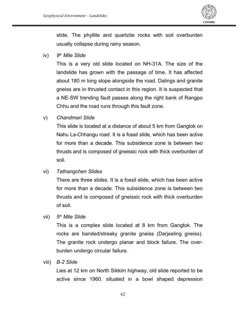
Geophysical Environment – Landslides
62
CISMHE
slide. The phyllite and quartzite rocks with soil overburden
usually collapse during rainy season. iv) 9th Mile Slide This is a very old slide located on NH-31A. The size of the
landslide has grown with the passage of time. It has affected about 180 m long slope alongside the road. Dalings and granite gneiss are in thrusted contact in this region. It is suspected that a NE-SW trending fault passes along the right bank of Rangpo Chhu and the road runs through this fault zone.
v) Chandmari Slide This slide is located at a distance of about 5 km from Gangtok on
Nahu La-Chhangu road. It is a fossil slide, which has been active for more than a decade. This subsidence zone is between two thrusts and is composed of gneissic rock with thick overburden of soil.
vi) Tathangchen Slides There are three slides. It is a fossil slide, which has been active
for more than a decade. This subsidence zone is between two thrusts and is composed of gneissic rock with thick overburden of soil.
vii) 5th Mile Slide This is a complex slide located at 8 km from Gangtok. The
rocks are banded/streaky granite gneiss (Darjeeling gneiss). The granite rock undergo planar and block failure. The over-burden undergo circular failure.
viii) B-2 Slide Lies at 12 km on North Sikkim highway, old slide reported to be
active since 1960. situated in a bowl shaped depression

Geophysical Environment – Landslides
63
CISMHE
between B-1 and B-2 nalas. This landslides involves both rock fall and debris flow. The rock types exposed in the area are granite gneiss which are intensively sheared.
ix) Chawang Slide
It is an old landslide cone on the right bank of Dikchu, where
settlements are developed. Due to heavy precipitation during
2005 this landslide cone undergone creep and circular failure.
This destroyed some of the houses and the road as well as the
agricultural fields developed on this slide
x) Slopes along Singtam-Dikchu road section
The Singtam-Dikchu road section on the left bank of Teesta
river has been affected by a number of slides and sinking zones
viz.
a) Sherwani Slide Zone : This slide is known as Sherwani slide
zone, is situated about 1 km away from Singtam. This is a rock-
debris slide whose crown portion extends 60 m above the road
level and slide materials have descended down to Teesta river
bed. The rocks are quartzitic phyllite or phyllitic quartzite. Rock-
cum-debris fall and debris flow are the characteristics.
This is a slide complex with several active scars and old
stabilised scars (Plate 2.1)
b) Ghatte Khola : This is a 250 m to 350 m long sinking zone
on the left bank of Ghatte Khola. The slopewash materials

Geophysical Environment – Landslides
64
CISMHE
composed of finer matrix (> 70%) and smaller clasts with
occasional big boulder undergo circular failure.
The thaw imparted by the weight of landslide cone damage the
retention wall (Plate 2.2). Human settlement is developed on
this slowly creeping slope (see Plate 2.2).
c) Elaichi Khola sliding/shooting boulder zone (Rock-debris
slide) : It is located about 6.5 km from Singtam. The rocks
exposed in this region are phyllitic quartzite and phyllite steeply
dipping (45o - 60o) towards north. They are well jointed. This
Khola represents a shear zone. The pulverized rock flows down
hill during the rainy season. Rectangular blocks also fall down
along the valley.
Part of the old landslide cone is stabilized by vegetation growth
on it and part of it suffer circular failure (Plate 2.3)
d) Ralap I and Ralap II : Near Ralap, two sliding/sinking zones
named as Ralap I and II are found respectively at 8.6 km and
9.3 km from Singtam. Phyllitic quartzite, phyllite and quartzite
are exposed in this area. They are well jointed and contain iron-
oxide stains. Block failure of the rocks and circular failure of the
loose materials are observed.
e) Singtel Sinking zone (200 m long) : Lies at 12.6 km from
Singtam near the village Singtel. The phyllitic quartzite and

Geophysical Environment – Landslides
65
CISMHE
quartzitic phyllite rocks are covered with boulders and soils. This
area is sinking as marked by hockey stick like configuration of tree
trunks (Plate 2.4). f) Mangkha Sinking Sliding Zone : Mangkha sinking sliding
zone affecting about 500 m long road sections is located at 13.3 km. This is a rock cum debris slide. The terrace at Mankha is also undergoing circular failure. The basement rocks are phyllitic quartzite. They are fractured and jointed. This is also characterized by fall of large boulders.
g) Sansari and Tintek Khola shooting boulder zones : These
are located at 21.5 km and 28.7 km, respectively from Singtam. The rock types in this region are well jointed quartzitic phyllite and phyllitic quartzite (Plate 2.5). Here, rock fall and debris slide takes place during monsoon season.
2.3.1.3 West Sikkim Landslide and slope failures cause serious problems in the West Sikkim. Every year, during the monsoon period, landslides disrupt the roads of the district. The areas between Dentam-Uttare, Kaluk-Dentam, Nayabazar-Sombarey, Legship-Gyalzing and Nayabazar-Legship are severely affected by landslides. In August, 2000, a devastating landslide occurred in Kyongsa near Gyalzing. Heavy rain during this period lead to slope failure that caused loss of life and property.

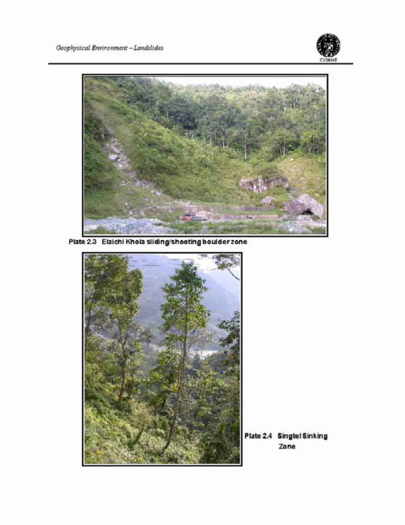

Geophysical Environment – Landslides
66
CISMHE
2.3.1.4 South Sikkim South Sikkim has experienced intensive landslide activity in the
past as the slopes are covered with large boulders. At present, slope
failure is observed along some new road cuttings. Besides these, in
some of the streams debris, through slope failure in the headwater
regions, is put into the channel and are carried into the main Teesta
channel. Some of the slides are slope failure near Payong, Kasur at
the right bank of Teesta valley, and Brang and Sulpukh in Rangit
valley.
2.4 CASE HISTORIES OF SOME IMPORTANT LANDSLIDES 2.4.1 The Rangpo-Dikling Landslide complex A devastating landslide took place on the July 23, 1993, along
the Rangpo-Dikling Road. This landslide resulted from the failure of
hillslope (Fig. 2.4) at 1.5 km (27o 11’15’’ and 88o 33’E) from Rangpo
and disrupted the traffic for a couple of days. Subsequently this slide
has been well studied by Sarkar and Deb (1998). This region is
characterized by several landslide scars and tongues.
The region extends from 350 m - 640 m. The slope dips at 42o-
50o and Daling series of rock is exposed in this region (Gansser,
1964). The lithology includes slates, green quartzites, phyllites,
chlorite sericite schists and chlorite quartz schists. These rocks are
traversed by quartz and quartzo-feldspathic (5 cm thick and 5 m long)
veins and are highly jointed. The rocks strike in NE-SW, NNE-SSW

Geophysical Environment – Landslides
67
CISMHE
and EES-WWN directions with varying dips (30o to 50o). Scattered
bushes, shrubs and bamboo cover the slope at places. Teak
plantation is also found at some places. The slope is terraced for
farming. During the rainy season, the soil covering the slope is
partially saturated. The landslide is triangular and elongated in shape.
The length of the scar is 800 m and its width varies from 25 m to 500
m. This is a debris slide and mud-rock flow. Total area affected is
20.8 ha.
2.4.1.1 Factors responsible for this landslide
The following factors were responsible for this landslide activity.
i) Local geology : The Rangpo landslide has precisely been
identified to be on the phyllite, with occasional bands of slate
and quartzite (see Fig.2.4). These rocks are highly jointed and
weathered. Rainwater seeps through these rocks and chemical
weathering forms kaolin, which acts as a lubricant for
further sliding of slope materials. Rangpo river, with high
discharge, causes toe erosion and thus the basal support of the
slope is reduced.
ii) The soil cover : The soil cover is usually 30-50 cm thick. It is
kaolinitic with high organic content, high water holding capacity
and volume expansion.
iii) Deforestation : The hill slopes are deforested. They have been
turned into cultivated terraces and settlements. Therefore, the


Geophysical Environment – Landslides
68
CISMHE
soil on this slope has lost cohesiveness and the slopes have
become vulnerable to erosion.
iv) Precipitation and Infiltration : Percolation of rainwater through
joints, cracks and fissures of bedrock and the pore-spaces of soil and regolith increases the pore-water pressure and changes the consistency and shear resistance of the slope materials (Sarkar and Deb, 1989 and references therein). The slope in the region being devoid of adequate vegetative cover, the material on the slope absorbs monsoon rain (>3000 mm) and leads to onset of rill cutting and gully erosion, thereby triggering slope failure.
v) Effects of Human Interference : Removal of basal support
through cutting of slopes for construction of the road between Rangpo and Dikling during 1980s is an important anthropogenic factor that triggered massive Rangpo landslide. Deforestation has further aggravated the induced erosion of the slope materials.
2.4.2 Chandmari- Tathangchen landslide complex In 1984 prominent slope failures occurred on the left and right banks of Chandmari jhora, Palace jhora, and Tathangchen jhora near Gangtok (Fig. 2.5). These slides affected the southeastern hill slope of the northeast-southwest trending Mintokang-Palace-Tashijing ridge. For this reason the southeastern slope of the hill, on which Gangtok city is situated, has a major stability problem, and has been a source of constant fear for the entire habitation on it.

Geophysical Environment – Landslides
69
CISMHE
Figure 2.6 shows the geology of the region. There is Daling Group of rocks between two thrusts trending NW-SE. Chandmari jhora flows along the eastern thrust. Therefore, the rocks on its left bank are banded gneiss/streaky gneiss (Darjeeling gneiss) and those on the right bank are Daling rocks. The foliation dips 43o – 55o eastward. The weathered and crushed rocks are overlained by thick soil cover. Large scale developmental activities viz. construction of roads and other super-structure vis-a-vis deforestation are also operative on this hill slope. Four different slides that occur in this complex (see Fig. 2.5) are : i) Chandmari Slide : This slide was active during 1975-76 and
thereafter, remained stable till 1984. During June, 1984 it was reactivated. In this subsidence zone highly crushed and weathered granite gneiss is overlained by thick soil cover. During the monsoon rain, the rock and the soil overburden collapsed. This landslide became an immediate concern because it damaged a number of houses, a school complex, a temple, a government vehicle workshop and a number of parked vehicles.
ii) Palace Jhora slide : This is an old slide which was caused by
toe-erosion near the confluence of the Palace Jhora with Rora Chhu. With the passage of time the headward erosion increased and the crown of the slide reached near the base of the road at the east of the palace. Therefore, the road undergoes subsidence.
iii) Tathangchen Minor Slide : Tathangchen minor slide is present
in a depressional area which is situated about 500 m northwest


Geophysical Environment – Landslides
70
CISMHE
of Palace Jhora slide. Sericite-chlorite schist constitue the
basement in this region. The rock units dip at 50o – 55o towards
the east. They are intensively weathered and covered with
regolithic soil. Planar failure along the foliation lead to valley-
ward movement of over-burden material and with weathered
bedrock during 1984 monsoon.
iv) Tathangchen Major slide : This landslide occurred in 1975. The
reactivation of the slide during the 1984 monsoon lead to its
lateral extension which ultimately affected areas further south.
An area of about 800-1,000 m length and 200-250 m width was
badly damaged. The debris from the active Chandmari slide,
that is situated in the east of this slide, rolled down the
Chandmari Jhora and caused toe erosion on the right bank.
Due to intensive toe-cutting Tathangchen hill slope failed. The
old landslide of 1975 was reactivated in 1984 and a new crack
developed upslope of the old scar (see Fig. 2.5). The debris
flown downstream and got deposited at the confluence with
Rora Chhu. Part of the sediment flux was carried downstream
by Rora Chhu.
2.4.2.1 Factors responsible for these landslides The Darjeeling gneiss is in thrusted contact with Dalings. The
phyllites, schists and gneisses are well jointed and crushed in this
thrust zone overlain by thick soil cover. This region receives intense
monsoon rain which percolates through the soil and weathered rock.
The region also experiences earthquake tremors (De and Kayal,

Geophysical Environment – Landslides
71
CISMHE
2004) which can trigger landslide activity. Beside these natural
causes, the construction of building and roads in the region and
deforestation are the anthropogenic factors responsible to reduce the
stability of the hill slope.
2.4.3 Landslide Complex in the region between Mangan to Tong Every year slope failures occur on the left bank of Teesta river
between Mangan to Tong. These slides occur along the streams
joining the Teesta river on its left bank. For this reason, North Sikkim
Highway is blocked particularly during the rainy season and the left
bank slope of Teesta along this highway is with major stability
problem, and has been a fear for the entire habitation on it.
Figure 2.7 shows the geology of the region. Rocks of the
Darjeeling Group are exposed in the region. Lithologically they are
Biotite-Muscovite Gneiss and Chungthang Formation rocks viz.
quartzite, calc-silicate-marble and graphite schist-gneiss. The foliation
dips at 21o – 35o towards NE therefore, failure takes place along
south bank of streams joining Teesta. At places, old terrace deposits
are covered with landslide cones. They also get reactivated due to
heavy precipitation in the region. The slides those occur in this
complex are:
i) Manul-I : This slide is located at 74.1 km on the North Sikkim
Highway. This is a 170 m long sliding and flood zone. The soil and
rock materials constitute a thick zone above the Biotite granite
overburden. This overburden material undergoes slow creep as


Geophysical Environment – Landslides
72
CISMHE
marked by hockey-stick like configuration of Alnus trees alongside the
road. This slide is active since 1983.
ii) Manul-II : This slide is located between 75 and 75.6 km on the
North Sikkim Highway. This is a 300 m long slide zone on the
Biotite Muscovite Schist (Plate 2.6). Boulder and powdered rock
material slide down along the stream gradient. This is a sliding
and sinking zone since 1983.
iii) Lanta Khola : This slide is located between 71.6 and 72.4 km on
the North Sikkim Highway. This is 800 m long and is
characterized by rock-cum-debris slide/flow (Plate 2.7). Thick
layer of fluvio-glacial non-cohesive material with large boulders
is present above schistose rocks at this site. Thick biotite bands
in the rocks lead to slippage and failure. Erosion of bank and
bed material at high river discharge/seepage above the crown is
the causative mechanism. This slide is active since 1978 and
has been a major concern because every year it blocks the
North Sikkim Highway.
iv) Myang Khola : The slide is characterized by rock fall on left
bank and debris slide/flow on right bank of Myang Khola. The
materials present in the landslide are quartzite blocks on left
bank and rock fragments with clayey material on right bank. The
cherty quartzite and granite gneiss are the basement rock. This
slide is characterized by rock falls along sub-parallel joint
planes and slides after heavy rainfall. The bed rock exposed
along the left bank of the Myang Khola undergo slippage

Geophysical Environment – Landslides
73
CISMHE
because it dips towards the valley. The rocks exposed at this
site are Biotite muscovite granite and quartzite. The attitude of
the quartzite beds is N20oE-S20oW, 48o → N70oE. This steam
has high discharge; the water flowing over the road interrupts
the traffic for some hours during the period of heavy rain (Plate
2.8). v) Ri Chhu : Thick layer of fluvio-glacial non-cohesive material with
large boulders present above Biotite muscovite granite, flows down the stream during the period of high discharge. Because of the high gradient of the stream the water rushes onto the road with high velocity (Plate 2.9). Therefore, the old bridge has collapsed and a new bridge has been built at a distance of only a few meters downstream. The materials carried down by the stream sometimes block the Teesta river as evidenced by a large bar with large angular boulders at its downstream side present at the confluence (Plate 2.10). Due to slow creep the protection wall of the road is deformed in the north bank of the stream (Plate 2.11).
vi) Tong Slide : This slide has developed only recently. An old
landslide cone covers a terrace (Plate 2.12). Due to road cutting and seepage the slope has collapsed recently.
2.4.3.1 Factors responsible for these landslides The biotite-muscovite bands in the granite gneiss are susceptible to chemical weathering. This region lies between MCT-I in the north and MCT-II in the south. Therefore, the rocks are sheared and crushed at places. In this region the left and right bank slopes of

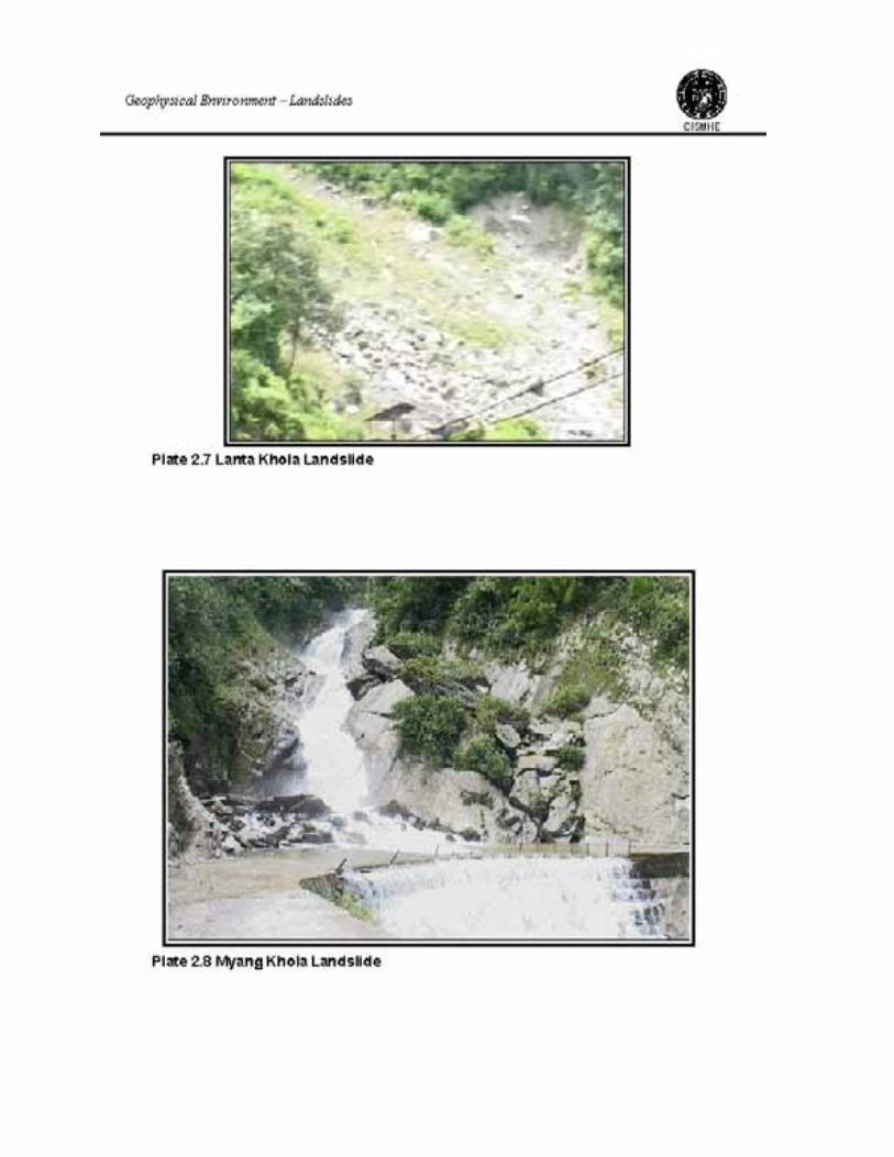


Geophysical Environment – Landslides
74
CISMHE
the Teesta river are very very steep. The precipitation is also very
high during monsoon period. Thick glacio-fluvial deposits and the
jointed and crushed bedrock provide channels for the percolation of
water. Therefore, during the rainy season this region experiences
immense landslide activity.
2.4.4 B2 Slide complex along Gangtok-Dikchu Road
It is situated at 12 km milestone on North Sikkim Highway. The
type of slide is slump associated with mudflow (Plate 2.13). Materials
in the landslide are slope-wash material and debris (Plate 2.14). The
granite gneiss is covered with silty and sandy soil with clay rich
horizons. The causative factors are toe erosion in the initial stage and
heavy precipitation, loss of shear strength caused by seepage. Biotite
rich bands undergo chemical weathering resulting clay minerals and
slumping/flow movement of clayey material results failure of the
slope. The B2 slide lies in the MCT zone (Fig. 2.8). It has three
stages. The intermediate stage is stable. The top crown is active due
to road cutting and heavy precipitation. The bottom stage is active
where the tongue of the intermediate landslide cone is collapsed (see
Plate 2.13 and 2.14). 2.4.5 Rangpo Slide
This slide is situated on the left bank of Teesta river on NH-31A
upstream of the Rangpo-Teesta confluence. The phyllitic quartzite
and slates at this site dip at 30o – 40o towards the river and are
covered by a mantle of weathered materials (Plate 2.15). During rainy

Geophysical Environment – Landslides
75
CISMHE
season, the percolating water removes the fine particles and increase
the pore pressure. This leads to rock fall due to loss of cohesion. 2.4.6 Lukhbir and Berrik Slides in West Bengal Lukhbir and Berrik landslides are in Darjeeling districts of West
Bengal. They are very important because they interrupt NH-31, the
only road route to Sikkim connecting Siliguri and Gangtok. At both the
sites Quartzites and carbonaceous phyllites are exposed at both
these sites. At the Berrik site there is a fault propagated fold (Plate
2.16). The carbonaceous phyllites undergo circular and block failure
along the roadside at the right bank of Teesta river.
2.4.7 Landslides along the Lachung Axis The rocks exposed in the Lachung axis are Kanchenjunga
augen gneiss, quartzites of Chungthang Formation, politic migmatites
and interbanded politic schists with metabasites, and tourmaline
granite. There are some dislocation zones present in this region.
Active landslide upstream of the Yumthang valley supplies sediment
into the valley (Plate 2.17). The vegetation cover developed on the
landslide cones provides stability to the slope. On the other hand,
slope failure due to toe cutting leads to destruction of vegetation
cover in the region. Glacier tongue on the right bank also supplies
large volume of unconsolidated rock fragments into the valley (Plate
2.18). These material also destroys the forest in the region and at
times lead to valley aggradation and change in river course.
Downstream of Yumthang, near Lachung, thick periglacial deposits

Fig. 2.8 B2 slide lies in the MCT zone

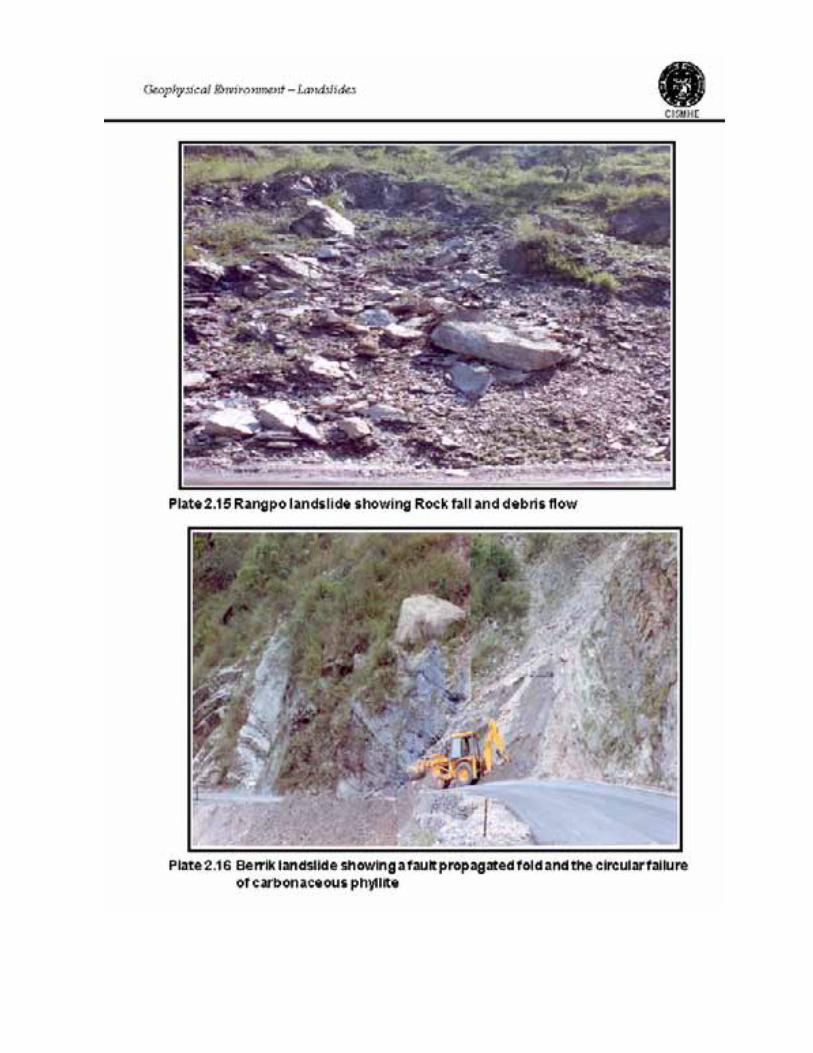

Geophysical Environment – Landslides
76
CISMHE
are preserved at several places (Plate 2.19). The collapse of these
deposits due to toe cutting increases sediment load in the river. This
may also lead to valley aggradation and subsequent outburst floods.
2.4.8 Landslides along Teesta upstream of Chungthang
The rock types exposed in this region are calc-silicate rocks
with interbanded quartzite, Kanchenjunga augen gneiss, tourmaline
granite, and politic migmatite and interbanded politic schists with
metabasites. Most part of the area is covered with glacial moraine,
periglacial deposits (terraces) and landslide cones.
Frost weathering upstream of Thangu has resulted in large
quantity of debris. Debris delivered to the rock-wall foot accumulated
initially as an extensive apron or series of talus cones (Plate 2.20).
Seasonal melt is a major influence which affects the form of cones
and their onward transfer processes. These unconsolidated angular
rock fragments can be carriedout down stream in the event of heavy
precipitation or glacial lake outburst. Immense landslide activity due to
heavy precipitation in the Higher Himalaya leads to slope failure on
eitherbank, thereby supplying huge sediment load into the main
channel (Plate 2.21). Road building and frost action downstream of
Thangu result in the collapse of old depositional landforms (Plate
2.22). This increases sediments in the Teesta channel and may lead
to aggradation and subsequent lake outburst flood as well as change
in river course.

Geophysical Environment – Landslides
77
CISMHE
2.5 ENVIRONMENTAL IMPACT OF THESE SLIDES
Most of the landslides along the NH-31A, such as Rangpo slide
in East Sikkim, disrupts the traffic. Similarly, the landslide complex
between Mangan to Tong also disrupts the traffic on North Sikkim
Highway every year. Due to the dumping of material into the river the
sediment flux in the rivers increases. Increase of sediment flux may
have negative impacts on the aquatic ecosystem. Occasional
blocking of the rivers may lead to flash floods. Some of the landslides
affect the cultivable lands, thus leading to the wastage of productive
soils. Some landsides in the city area, such as Tathangchen slide
complex, damages the houses and leads to loss of life. At places,
particularly at the south of MCT, rock falls are observed during the
earthquakes (Plate 2.23).
Landslide debris, resulting from the developmental activities,
accumulate as loose scree that kills vegetation, chokes streams, and
creates new instabilities (Haigh et al., 1987; Haigh 2002). The
absolute importance of human-triggered landslides in the total
landslide budget of the Himalayan mountains is debated. Road
construction and deforestation rank among the major triggers for
landslide initiation (Bruijnzeel and Brenner, 1989). Each year, as
much as 550 cubic meters of debris may fall on each kilometer of
road bed (Valdiya, 1987). While human activities trigger many small
superficial landslides, the bulk of the landslide sediments which reach
mountain river channels come from large, deep seated, landslides
created by river incision or tectonic uplift (Bruijnzeel and Brenner,
1989). The Himalaya are young and rapidly evolving mountain range


Geophysical Environment – Landslides
78
CISMHE
(Valdiya, 1998) and these mountains undergo, in geological terms,
very rapid tectonic uplift and this encourages equally rapid incision by
river systems. The vast, steep slope of the mountains are the result.
The very steepness of these slopes testifies to the fact that many lie
close to the margins of their own stability. Even undisturbed, each
monsoon brings down thousands of landslides from hillsides in a
mountain landscape that has self-organised to a condition close to
the limits of its own geomorphological stability.
Landslide is the pertinent natural problem, which is intensified
manifold by human interferences particularly in active mountainous
regions like Sikkim Himalaya. Softer and incompetent rock formation,
rocks that are hard but incompetent due to fractures and joints,
massive deforestation, inadequate drainage, cultivation on steeper
slopes, toe erosion by stream, heavy loading/construction of massive
structures on unstable ground and seismicity of the region are some
of the factors responsible for landslide. Rainfall intensity in Sikkim
Himalaya has been observed to trigger landslide activity. In Sikkim
the roads are disrupted every year, especially during monsoon
period, by landslides. The forests are also affected by landslide and
erosion, which erode valuable forestland, destroy plantations and
retards the growth of forest produce. The areas that are most affected
are the areas covered by softer rocks viz. phyllites and schists of
Daling Group. However, the areas where harder schist and even
gneisses occur are also affected to a minor extent. In these regions
the mica rich bands in the rocks lend the rock to massive failure.

Geophysical Environment – Landslides
79
CISMHE
It is also very important to note here that many of the major
landslides of Sikkim viz. North Rhenok Slide, Tathangchen-
Chandmari slide, B2 slide, Chowang slide, Rangrang slide, Runchu
slide, Narkhola and Karchi slide, Dentam-Uttare slides, Sombre slides
lie in the region of MCT (see Fig 2.1). The active landslides on the
MCT are resulted due to the combined effects of i) road building, ii)
heavy precipitation and iii) seismic activity between MBT and MCT.
In the planning and implementation of projects in the hilly areas
sustainable development must be given due importance. One aspect
of sustainable development in a mountainous region is proper
examination of the existing instabilities of the terrain and
consideration of appropriate development schemes so that the
resultant geo-environmental hazards are minimized. Therefore,
systematic investigations need to be carried out on regional to local
scales. Due attention must be given to the relationship between the
attitude of lithounits and road alignments. For instance, a valley ward
dipping bedding plane/foliation can lead to slope failure on the road
side, while the road on the stable slope where the bedding/foliation
plane dip into the hill, is never affected by landslide and subsequent
blockage of traffic or death toll (Plate 2.24). Landslide hazard
zonation map is to be prepared with an objective to delineate zones
with different damage potential. This will help in planning and
implementation of projects under the milieu of sustainable
development.
The remedial measures that are usually adopted are i) sealing
of cracks with bitumen, ii) construction of good outlet of rain water in


Geophysical Environment – Landslides
80
CISMHE
the form of catch water drains, iii) rock bolting by wire mesh with
boulders extending down to the river bed to check the toe erosion.
These measures can be adopted at selective localities. However,
where unstable geological structures (viz. highly jointed igneous and
metamorphic rocks) are dipping towards the roads or river channels
the roads must be diverted from such areas.
2.6 REMEDIAL MEASURES TO PREVENT LANDSLIDES
Landslides are problems that if not attended, grow with time. It is,
therefore, important that they are tackled at the earliest opportunity and
undue time is not lost. More often than not an immediate solution, even
if partly correct or unconventional may prove more economical in the
long run than the most perfect solution adopted after the problem has
grown with time.
The corrective measures for a landslide can broadly be divided
into four categories.
(a) Keeping the soil mass free of moisture
(b) Increasing shearing resistance of the soil
(c) Protection of toes of road embankments
(d) Training of streams to prevent damage.
2.6.1 Keeping soil free of moisture
The commonest way of doing this is to provide catchwater drains
of a suitable section above the road formation. In case the terrain
comprises of very steep slopes in such catchwater drains, it may be

Geophysical Environment – Landslides
81
CISMHE
economical to line them with black polyethene sheeting, brick or
stone.
Very often, when dealing with sand or silt mixed soils, the
problem of moisture is not confined to only surface water, but sub-
surface water also exists. In this case, open drains are dug. These are
filled back with well designed porous fill of graded gravel- sand
mixtures and they are closed at the top with polythene or a clay seal to
prevent surface water going in. It may be indicated that in retaining
walls or breast walls, little attention is often paid to back filling such
walls after construction. If the back fill is too porous, which is often the
case with rubble fills, the velocity of flow of water through such a fill is
very high, which causes undermining in the soil retained. This
undermining is easily repaired but the fine material lodges itself in the
fill, thus making it impervious for any further movement of moisture.
Excessive hydrostatic pressure is a common cause of failure of breast
walls and retaining walls.
A technique which has not been tried extensively in India but
which holds much promise is the provision of horizontal drains. For
want of accessibility to mechanical equipment’s at every site, this
measure may have practical difficulties. Well point de-watering had
been tried at some sites which consisted of jetting vertical pipes upto
required depth into which an airlift pump could be lowered. By pumping
compressed air into a series of such vertical pipes, occasional de-
watering of the soil could be done and this flow could be discharged
away from the site.

Geophysical Environment – Landslides
82
CISMHE
Bitumen mulching has also been tried at some locations and was found successful in keeping down surface percolation into the hill face, but it has exhibited that the face eventually cracks due to a rotational movement following toe erosion. 2.6.2 Increasing soil strength
Exclusion of moisture from the soil or rock mass prevents
decrease in dry soil strengths. The techniques covered here improve its ability to withstand shear stresses. When soil is clayey or silty clay, seasonal variation in moisture gives rise to serious stresses. Expansive clays assume a much higher volume and exert swell pressures on retaining structures, or on pavement. Equally destructive forces come into play if the soil dries out and shrinks away. Injection of cement or hydrated lime slurry into the soil mass under pressure forces the grout through paths of least resistance moving along fractures, bedding planes, sand lenses, seams, roots and fractures created by jetting slurry. It may be added that the grout could be lime cement sodium silicate solution, bitumen emulsion or cut back depending on the type of material to be strengthened. Fractured rock sets well with bitumen and cement, plastic clays with lime or cement, sands and silts with bitumen and sodium silicate. The action consists in providing a curtain against percolation of moisture, and in case of clays, improving their plasticity properties due to base exchange with the calcium ion of lime or cement.
2.6.3 Toe protection works
Toe protection works consist of rendering the face of hill in contact with forces of erosion non-erodable. This is commonly done

Geophysical Environment – Landslides
83
CISMHE
by erecting mass concrete, masonry or crated boulder walls. Slide is prevented from moving by a RCC mass concrete wall but at some locations, it has failed in overturning due to hydrostatic pressure owing to choking of drains on hill side . Mass concrete walls are also provided to prevent toe erosion. Dry stone walls in wire crate are suitable when placed on uncertain foundations. Unlike masonry wall which cracks due to differential settlement, these have a longer life. Masonry walls have failed due to rotational movement of slides. Selection and siting of toe protection works need care and experience.
2.6.4 River Training
River training works can be of several types.
(a) Training of subsidiary nallas joining main rivers.
These nallas should be provided with boulder check dams
upstream. These will prevent large scale movement of silt by
decreasing the slopes and the interference in the flow of main
streams will decrease. It may often be necessary to check
spillage of flood in the side streams by providing protective
bunds.
(b) Provision of groynes or guide bunds to prevent spilling of
main streams and preventing toe erosion.
Guide bunds have to be founded on firm soil-but it is
uneconomical to place groynes or spurs at the scour depth. In
such a case, it is often economical to site them suitably.
However these are required to be rebuild after the floods.

Geophysical Environment – Landslides
84
CISMHE
2.7 TYPICAL LANDSLIDE PROBLEM
The landslide problems being encountered in Sikkim have been
found to be mostly due to hydrological reasons. The case history of
one of the typical landslides occuring at 7th Mile Slide on Gangtok-
Kupup road describing its features, mechanism, treatment measures
recommended by experts of various organizations and by the
departmental authorities and those executed so far are outlined in the
following paragraphs.
2.7.1 Features
(a) This slide, falling in the 12 km of the above road, has been posing
subsidence problems since 1966. Ths length of the affected
stretch is about 400 m (1300 ft) and the average up-hill and down
hill slopes are 30o and 40o, respectively. The slope length from
crown to road level is 152 m (500 ft) and from road level to toe is
700 m (2,300 ft). A big nallah (known as MS 8/7 nallah) also flows
at the toe of this slide.
(b) The slide material involved consists of matrix of boulders of biotite
gneisses in silty soil. Though sheet rock has been exposed on the
Gangtok end of the slide, the depth of the moving mantle could
not be assessed/ determined. The down hill slopes are full of
springs and seepage. Heavy water flow has been noticed even a
few feet below the road formation. During the monsoons of 1967
to 1969, the formation was completely damaged and fresh
formation had to be cut every year.

Geophysical Environment – Landslides
85
CISMHE
2.7.2 Mechanism
(a) The annual rainfall in the area is about is about 5,000 mm (200
inches). During the monsoons the silty soil, in which the boulders
are embedded, gets completely saturated when creep sets in.
This also provides lubrication for the boulders to slide down due
to gravity, with the result that the whole mass starts flowing
resulting in subsidence.
(b) There are several small streams on the up-hill slopes of this
slide. The discharge from these streams and also the surface
run-off up hill of the shear line enter into the ground through the
shear line, providing further lubrication for the sliding planes.
(c) On the down hill, the toe of this slide is being eroded by frequent
floods in the MS 8/7 nallah. The hydrostatic and seepage’s
pressure developed have been further assisting the erosion of the
toe.
2.7.3 Treatment Measures
The following works were executed in consultation with the
Central Road Research Institute:
(a) A peripheral catch water drain above the crown of the slide was
constructed.
(b) Treatment of up-hill and down-hill slopes by spraying two coats
of cut back bitumen to prevent percolation of surface run off and
to provide cohesion at the surface.

Geophysical Environment – Landslides
86
CISMHE
(c) Breast wall in combination with a 1.8 m (6’) deep road side drain
to trap the springs below the formation.
(d) Road retaining structures in sausage work (dry stone masonry
filled crates in wire mesh).
The above work proved a success and the subsidence of
formation during the monsoon of 1970 to 1973 were minor. In the
monsoons of 1974, the road formation and catch water drains suffered
extensive damages, which were repaired. The slide has shown sign of
extension towards the Kupup end. One main reason for this was found
to be the ingress of the discharge from a stream flowing on this end of
the slide area which is being trapped and diverted away from the slide
area.
Therefore, in addition to the above measures, it was proposed to
provide toe walls so that the toe erosion problem is cut down. To
reduce the pressure on the toe walls it was also proposed to provide
trench drains on the down hill slopes to trap and lead the subsoil water.
Site Plan of the slide is given is given at Fig. 2.9.
2.7.4 Various forces to be considered
Relevant data in respect of geology, hydrology and seisomology
of the area is essential to determine the design parameaters and to
asses the forces acting on the structure subjected to land slide. Some
of the mainload / forces acting on the structures are described below.

Geophysical Environment – Landslides
87
CISMHE
2.7.4.1 Weight of Structure Weight of structure and imposed vertical loads act vertically
downwards though its centre of gravity.
2.7.4.2 Lateral earth pressure (i) When retaining soil surface is horizontal, pressure intensity (p)
at any depth ‘h’ is given by
p = wh
Lateral pressure ‘P’ therefore, per unit length of wall for dry and ideal
soil is given by :
P = wh2 acting at h/3 from base
(ii) When retaining surface is horizontal and wall carried super load
‘q’ per unit area, equivalent height of wall , he = q/w and
p = w (h+ he)
(iii) When structure is to carry superimposed load inclined at an
angle to the horizontal and direction of p is parallel to surcharge.
φφ
sin1sin1
+−
φφ
sin1sin1
+−
φφ
sin1sin1
+−
φφαα
φαα22
22
coscoscos
coscoscos
−+
−−p = wh. cos α

Fig.2.9 Site plan of 7th mile slide on Gangtok-Kupup road

Geophysical Environment – Landslides
88
CISMHE
Above formulae presuppose that moisture content has optimum
value, materials on the back are granular, non- cohesive and ideal,
but soils in actual practice do not behave in this manner. In order to
make correct assessment of lateral earth pressure, pressure
diagrams should be constructed from actual data. By plotting results
of various observations on graphs and interpolation of data, suitable
values of ‘p’ in terms of variable parameter ‘h’ can be obtained for
design calculations.
2.7.4.3 Wind pressure
Wind load may be assumed as 150 kg/ m2 acting horizontally at
h/2 from bottom of the superstructure on theoretical consideration for
the State of Sikkim
2.7.4.4 Hydrostatic pressure of water
If the back fill happens to be cohesive and the structure is
impinged by large quantity of water, structure will experience
Hydrostatic pressure of intensity,’ P’ given by
P = wAx
Where w is the specific weight of water, A is the surface area on
which pressure acts, and x is the distance of Centre of Gravity (CG)
vertically below such soil level.
In case of structures which have already been constructed for
ideal soils, and above conditions are encountered, suitable net work

Geophysical Environment – Landslides
89
CISMHE
of subsoil drains should be provided.
2.7.4.5 Hydrostatic uplift
If the structure is wholly or partly submerged in liquid, it will
experience upward force exerted by the liquid and its magnitude will
be equal to the weight of displaced liquid. This force acts at the point
known as center of buoyancy which coincides with CG of the
immersed portion of the structure.
Stilling basin and aprons designed for all relevant conditions
and loads at times fail due to this upward force known as buoyancy.
2.7.4.6 Seepage force
Seepage force ‘F’ is given by
F = wiza
Where, w is the density of water,
i is the hydraulic gradient
z is the thickness of soil mass through which water percolates and
a is the total cross sectional area through which seepage pressure
acts.
Amount of seepage is determined by discharge measurements.
These measurements have to be made with great precision and
repeated on numerous occasions at various stages. Geological
location of gauging sections at suitable intervals can render
evaluation of effects of under flow channels, faults or other

Geophysical Environment – Landslides
90
CISMHE
discontinuities that may intersect streams and kholas between
gauging stations.
2.7.4.7 Ice pressure
Any structure subjected to slow or freezing rain is normally
designed for snow load of at least 45 kg/m2. The amount of snow fall is
usually expressed in terms of its water equivalent, i.e. the depth of water
that would result from its melting. Forces exerted by snow are based
either on experience or empirical formulae because of complexities of
density, conversion to water, flowage and evaporation etc. The areas
where the soil freezes between 1.5 to 2 m alternate expansion and
contraction of the upper layer of the soil produces ice pressure due to
freezing and thawing of water in it. This poses serious problems for
roads and allied structures due to the freezing soil expansion because
of the formation of ice. When this expanded soil thaws, cavities are
formed. The solution of this problem partly lies in provision of adequate
drainage system.
2.7.4.8 Seismic forces
Seismic forces act at the CG of the body or at the CG of the
section of the body above any horizontal plane passing through the
structure. Both horizontal and vertical seismic forces must be
considered.
Horizontal seismic force ‘H’ is given by
H = ( a / g ) W = cW

Geophysical Environment – Landslides
91
CISMHE
Where, a is the ground or seismic acceleration such as the
acceleration of the earthquake wave
g is the acceleration due to gravity
W is the weight of structure or its components and
c is the seismic factor
2.7.4.9 Dynamic impact
An accurate evaluation of the impact on the roads and allied
structures is a complex process as it depends on wheel loads, speed
and surface conditions. When structures are subjected to moving or
rolling loads, impact effect are based on empirical formulae : e.g. for
bridges it is generally taken as 4.5 / (6+l) where ‘l’ the span in meters.
Structures on which it is expected that load “W” of slides is expected,
the structure should be designed for an intensity of 2 W/A and not
W/A. This is based on strain – energy relation. Design of retaining
walls, breast walls, and toe walls is based on various earth pressure
theories.
2.8 FLOOD PROBLEM
Flood problems in the predominantly hilly terrain of Sikkim are
mainly that of inundation of marginal lands on low river terraces and
erosion of land by rivers and hill streams. While the flooding due to
over bank spills is not serious and is confined to isolated patches
affecting a total area of 10,000 ha, land erosion poses a serious
threat to rural and urban population, strategic lines of communication,
public utilities, agricultural lands, plantations, forests and mineral

Geophysical Environment – Landslides
92
CISMHE
resources. Erosion of land has even more adverse effects on
environment and ecology not only in the affected areas but also in the
plains lower down where the heavy loads of debris are deposited in
the river beds and flood plains aggravating the intensity of flood and
disturbing the river regime.
The loss of land and the process of environmental degradation
are irreversible and therefore preventive and protective measures
have to be taken in right earnest. The cost of inaction can be
enormous in terms of loss of human lives and natural resources
besides set back to developmental programmes and economic
activity. These aspects have been considered in the context of very
limited availability of utilizable land in hilly areas and even more
limited range of options for development.
The average annual damages due to floods in the state are as
follows:
Area affected = 0.01 mha (max 0.02 mha)
Population affected = 0.005 million (max 0.1million)
Damage to Crops
Area = 0.001 mha (max 0.02)
Value = Rs. 0.415 crore (max Rs. 7.63 crore)
Damage to houses
No. = 427 (max 9746)
Value = Rs.0.054 crore (max Rs. 1.83 crore)
Cattle Lost = 91 (max 3260)
Human lives lost = 6 (max 107)
Damage to Public Utilities = Rs.1.94 Crore (max Rs. 28.15 crore)

Geophysical Environment – Landslides
93
CISMHE
The above data does not include the damage to roads
maintained by the Border Roads Organisation (BRO). The enormity of
the problem can be appreciated from the fact that they have to
remove about 650 cum of debris every year per kilometre of road
under their jurisdiction.
2.9 SOCIO-ECONOMIC IMPLICATIONS OF FLOODS AND LAND
EROSION/ SLIDES
While the flooding due to over bank spills is not very serious
and is confined to isolated patches affecting a total area of 10,000 ha,
land erosion poses a serious threat to rural and urban population,
strategic lines of communication, public utilities, agricultural lands,
plantations, forests and mineral resources. The erosion of land has
even more adverse effect on environment and ecology not only in the
affected areas but also in the plains lower down where the heavy
loads of debris are deposited in the river beds and floods plains
aggravating the intensity of flood and disturbing the river regime.
2.9.1 Flood Management works in Vogue 2.9.1.1 Sausage walls
The inundation of marginal lands by rivers and streams in the
state is limited to low river terraces, but the main problem is that of
bank erosion either due to direct river attack or due to sloughing of
saturated bank material. The protection works in such cases are
usually in the form of sausage walls with concrete lining in one or
more steps.

Geophysical Environment – Landslides
94
CISMHE
Where, a varies from 0.6 m to 0.9 m
h = as per site condition
h1 = 1/3 of c
c = a + h/3
Where the banks are high, slope protection works are often
necessary above the concrete lined walls. These are in the form of
sausage walls with out concrete lining.
2.9.1.2 Stream (Jhora) training works
Many hill streams erode the toe of their banks causing land
slides on either side. Training of such streams is done by providing
standard protection works along both the banks and in the bed.
While the bank protection in done by sausage work with 0.3m
thick concrete lining, bed protection is done by 1:2:4 concrete lining
over 1:4:8 concrete base laid over boulder soling. In order to take
care of low discharges, a semi circular pre cast RCC cunnet section is
provided in the middle of the bed. There are standards designs,
depending upon the channel size and discharge of the stream. One
of the typical design is as follows:
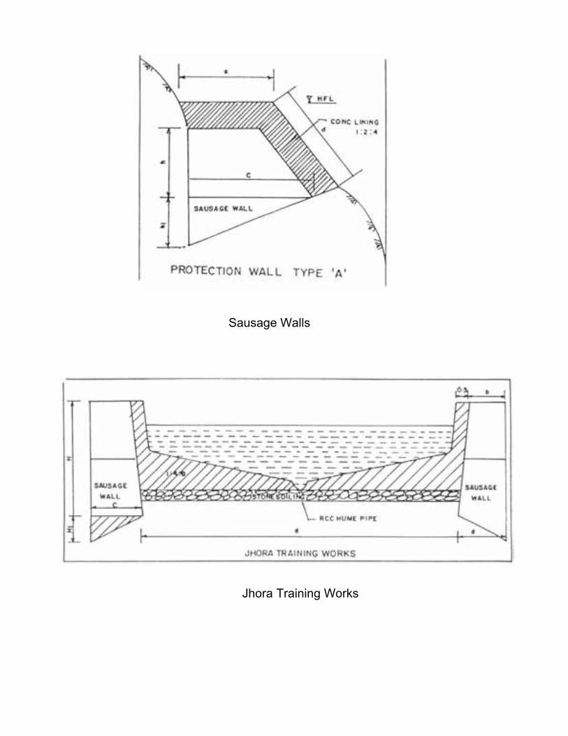
Sausage Walls
Jhora Training Works

Geophysical Environment – Landslides
95
CISMHE
Where, a varies from 1.0m to 7.0m
b =b + H/3
c =1.3 to 3.2 m
d = 0.9m
H = as per site condition
H1 = 1/3 of c
2.9.1.3 Catch water drain
The erosion of hill slopes and land slides are often caused due
to inadequate drainage. Such cases are conspicuous due to the
presence of numerous rills and gullies and signs of land sinking and
slides. Excessive flow of storm water and consequent expansion of
gullies down the hill slope causes damage to habitations, lines of
communication and public utilities. Preventive measures therefore
have to be taken in the form of catch water drains across the hill face
to safely discharge the monsoon run off into the nearest drainage
channel. Typical section of a catch water drain is as follows.
2.9.2 Performance of Flood Management Works
By and large stream (Jhora) training works, and catch water
drain perform well and meet the objective. Stream training works,
however, often suffer damage to the concrete lining in the bed due to
settlement of the stone soling or due to rolling of heavy boulders or
both. The side walls are rarely affected.

Catch Water Drain

Geophysical Environment – Landslides
96
CISMHE
Anti-erosion works to protect river banks also perform well since
the main ‘pucca’ wall is usually protected by sausage work near the
water edge.
The works which are most frequently damaged are the sausage
walls due to settlement of hand packed boulders. Damage is also
caused due to excessive active pressure from the sliding slope
material. Maximum damage to protection works, therefore, occurs in
active land slide zones. The hill slopes with thick over burden of
clayey soils or morainal material usually have slides in the form of
mud-cum-debris flows. Protection works in such cases are relatively
more susceptible than those in rock slide areas. In the latter case,
damages occur in the intial stages but get reduced over time as the
slide zone gradually gets stabilized. The works taken up by I&FC
Department are mostly in the potential land slide areas and relatively
few in active land slide areas. The works, therefore, perform better
than those of General Reserve Engineering Force (GREF) who have
to provide protection to the strategic road communication network
mostly in active land slide zones.
2.9.3 Formulation and Implementation of Schemes
Sikkim has active Panchayti Raj institutions. The panchayats
take active part in formulation and implementation of all rural
developmental schemes including flood management schemes. The
Government of Sikkim has laid down procedures which require, inter-
alia, all schemes to be formulated in consultation with the
Panchayats. For small schemes costing upto Rs.10.00 lakhs, the

Geophysical Environment – Landslides
97
CISMHE
Panchayats are also involved in the tendering process and award of
work to the contractors. Since the works are intended to protect the
life and property of the villagers, rural development works, valuable
lands under crops and plantations, the local people take keen interest
in the supervision during construction.
2.9.4 Evaluation of Flood Management Works
The Rashtriya Barh Ayog (RBA) has recommended that anti-
erosion works should not be taken up to protect agricultural land and
should only be taken up to protect towns, village abadies, public
utilities and strategic lines of communication. They have gone into the
problem of landslides in the context of heavy sediment loads in some
rivers, and the related problems of flooding and erratic behavior of
rivers. In this connection they have recommended certain regulatory
measures to minimise inflow of sediment load into the rivers. No
specific recommendations have been made for anti-erosion works in
hilly areas. There are, however, certain precedents to go by. These
provide a clear insight into the general approach of the Government
of India in this regard.
Various central teams, which visited the state from time to time
to assess the damages due to floods and to recommend Central
assistance for relief and restoration measures, have taken the
following aspects into consideration:
• Damage to houses, roads, bridges, irrigation canals/works, power
and telephone lines, drinking water pipelines, plantations and crops.

Geophysical Environment – Landslides
98
CISMHE
• Damage to rural development works
• Loss of humans lives
• Loss of cattle and poultry
• Damage to existing hydro-electric projects
• Land use and environment
Since most of the schemes are of minor nature and are
scattered over a vast hilly area their performance has been assessed
in general qualitative terms taking into consideration the following
main aspects:
i) Broad assessment of the extent of problem in qualitative
terms in respect of each scheme,
ii) The nature of works taken up under each scheme with
estimated cost and year of construction,
iii) Condition of the various structural components. Damage, if
any suffered during previous floods and apparent causes
thereof, and
iv) Weather or not the works have been effective in providing
the desired protection.
The evaluation studies in terms of above aspects for a few
important schemes in each district as undertaken by WAPCOS under
a separate project are given below.

Geophysical Environment – Landslides
99
CISMHE
2.9.4.1 South Sikkim (i) Jhora Training Work, Catch Water Drain and Anti-Erosion
works at Goshkhan Jhora at Namchi- Estimated Cost Rs. 55.43 lakhs Goshkhan Jhora drains the western side of Namchi town. All
the surface run-off from the Namchi-Namthang and Namchi-
Nayabazar roads and the Bazar area drains into the Jhora. The Jhora
has a wide valley and steep bed slopes. The banks are friable due to
highly sheared weak rocks at the base and the overlying clayey
material. There are many scars of previous land slides and active
gully formation on both banks. The Jhora carries a normal flood
discharge of the order of about 4 cumec. The upper parts of the Jhora
slopes have considerable urban habitations and a stretch of the
Namchi-Wok road. There are a few houses in the lower part of the
slope which are even more susceptible to slide.
The I&FC Department had earlier carried out training of the
Jhora in a length of about 400 metres. In view of the continued threat
to the urban and sub-urban population of Namchi Bazar and the lines
of communication the Department carried out further training of the
Jhora in a length of 550 metres. The works under this scheme under
reference are in the form of guide walls to protect the Jhora banks
and drop walls to minimise the impact of high monsoon flows on the
bed. In order to stablise the hill slopes against sliding breast walls
have also been built.
The immediate objectives of the protection works are :

Geophysical Environment – Landslides
100
CISMHE
a) Protection of urban and rural habitation of Namchi Bazar.
b) Protection of Namchi-Wok Road.
c) Prevention of gully information on steep hill slopes.
The training works have apparently performed well during the
monsoons of 2000 and 2001 since these are no signs of any damage
to any of the three components. These are also no signs of any fresh
erosion or sinking/sliding of the hill slopes in the protected area.
(ii) River Training Works on river Teesta at Melli- Estimated Cost Rs. 51.9 lakhs Melli Bazar township is situated on two natural terraces on the
right bank of the Teesta river. The upper bank is relatively stable due
to the presence of rock out crops at its base. The lower terrace is
prone to erosion due to toe-cutting by the river. The terraces and the
river bank are composed of morainal deposits of boulders and silty
clay. The bank slopes are steep being 0.5: 1 to 1:1.
The riverbed has a huge deposit of large boulders on the right
bank, which protects part of the bank against erosion during low and
medium floods. However, during high floods the bank is prone to
erosion. Remaining part of the bank extending beyond this boulder
deposit is exposed to river erosion even during low floods. During
high floods, the old retaining wall protecting the school playground
also comes under river attack.
Geophysical Environment – Landslides
101
CISMHE
The objective of the protection works is to prevent toe cutting
and slope protection. The works constructed are as follows:
i) Apron along the water edge in boulder sausages 1.5 m high
and 2.5 m wide at the top.
ii) Plum concrete wall 3.08 m high and 0.9 m wide at the top. This
wall is protected upto 1.5-m height by the apron.
iii) 2 m high sausage wall at higher elevation to protect the hill
slope against sliding.
iv) Plum concrete filling 0.3 m thick between the plum concrete wall
and sausage wall.
The works have faced two floods and are in good condition
except for some minor damage to the apron due to the impact of
rolling boulders. The damage to the apron is to be excepted since it is
meant to protect the main wall.
2.9.4.2 West Sikkim
(i) Jhora Training Work and Catch Water Drain and Anti-
Erosion Works below 16th km Sombarey Hilley Road- Estimated Cost Rs. 51.49 lakhs The works taken up during 1999-2000 had following main
components besides a large number of small components.
a) Protection works at Bhalu Jhora at Bharang.
b) Training works at Basbotey Jhora at Rumbuk.

Geophysical Environment – Landslides
102
CISMHE
c) Jhora Training works at Maley Dunga, Siktam Tikapur.
d) Jhora training works at lower Siktam.
It is understood from the Panchayat members that the schemes
had been formulated to protect the worst affected areas in
consultation with them. Since, the area under this slip is large being
of the order of 20 ha and required comprehensive protection
measures, the various components of the scheme were planned as
per the priorities decided by the Panchayat in consultation with the
affected people taking into consideration the limited availability of
funds. The Panchayat and local people were fully involved in the
implementation of the scheme. More importantly, they participated in
the process of tendering and award of work to the contractors and
construction supervision.
The works at Bhalu Jhroa (Bharang) and Basbotey Jhora, which
were inspected, are as per the standard design of the state
government. These are in the form of sausage walls in a total length
of 300 m. The objective of the schemes is to protect the village abadi,
road, plantations and agricultural crops. The works were taken up in
December, 1999 and completed in October, 2000. These have stood
two flood seasons and are in good condition. The works have
provided the desired protection.
(ii) River Training Works at Kalej Khola, Dentam – Estimated
cost Rs. 20.00 lakhs Kalej Khola has a wide channel with rocky outcrops and
boulders in the bed and the banks. Above the rocks and boulders, the

Geophysical Environment – Landslides
103
CISMHE
hill slope is steep with an angle of about 60o. The hill slope is
composed of friable material which is mainly a matrix of silty clay,
boulders and rock fragments.
During low floods, the Khola banks are well protected by the
armour of rock and boulders, but during medium and high floods the
toe of the hill gets eroded leading to land slides. The problem is
further aggravated due to erosion of the hill slopes by two Jhoras
which outfall into Kalej Khola. One of the Jhoras has since been
channelised and trained by the Forest Department and the other by
the Irrigation & Flood Control (I&FC) Department under funding from
NABARD. However, due to toe erosion by the Khola, the hill slope
was slowly sinking in an area of about 20ha. As a result, the Dentam-
Uttaray and Pelling-Dentam roads were under serious threat.
Besides, the cash crops of cardamom on the hill slopes was also
getting damaged. The protection works in the form of plum concrete
walls and sausage walls have effectively arrested the land
slides/sinking.
2.9.4.3 North Sikkim
(i) Jhora Training Works at Bojoghari- Estimated Cost Rs. 24.40 lakhs
The Jhora passes through the rural habitation of Bojoghari. In
recent years, the Jhora has eroded its banks causing damage to the
local habitations and Indira Byepass road. The threat to the road is
serious since it is also used by the army. The total length of the

Geophysical Environment – Landslides
104
CISMHE
sliding area is about 300 m. The Jhora has, therefore, been trained in
a length of 300 m above the road.
The works constructed under the schemes are PCC wall on the
sides and cement concrete lining in the bed. The structure has stood
the floods of 2000 and 2001 except for some damage to the concrete
lining in the bed. The works are generally in good condition and have
arrested the landslide/sinking of the hill slope.
(ii) AEW/JTW/CWD at Kabi Tingda - Estimated Cost Rs. 14.00
lakhs
The area of Rongdong- Tumlong village is under threat of
landslide/sinking due to toe erosion of hill slope by a local stream.
The hill slope has a large number of habitations of the village. The
erosion is posing threat to some houses, lines of communication,
cardamom plantations and agricultural fields. The length of the sliding
zone is about 200 m.
To protect the village habitation, the I&FC department has
constructed the works under seven different estimates as follows:
i) Catch Water drain and anti-erosion works at Phodong- Rs. 2.18
lakhs
ii) Catch Water drain and anti-erosion works at Kyonghu,
Phodong- Rs. 0.54 lakhs
iii) Catch Water drain and anti-erosion works at Phodong- Rs. 0.99
lakhs

Geophysical Environment – Landslides
105
CISMHE
iv) Catch Water drain and anti-erosion works at Yongyong- Rs.
1.42 lakhs
v) Renovation of Fauji Jhora- Rs. 2.50 lakhs
vi) Protection Works and catch water drain at Lapsi Dara- Rs.2.49
lakhs
vii) River training works at Longbu in Kabi- Rs. 3.51 lakhs
These works are said to be scattered over a large area and are
said to have been taken up on the specific request of the Panchayats.
The work mentioned at S. No. (vi) was randomly chosen for
evaluation.
The hill slopes in the vicinity to Kabi Tingda village have poor
drainage. Because of meager vegetative cover, the monsoon runoff
has carved out numerous rills and gullies. A local Jhora is also
eroding its banks. As a result, the village habitations including the
development works done by the Rural Development Department are
under serious threat of damage. In order to provide immediate
protection, the I&FC Department has built a catch water drain and
Jhora training works. These works costing Rs. 2.5 lakhs have
afforded benefits to a population of about 450.
(iii) Jhora Training Works of Rafong Khola at Mangan-
Estimated Cost Rs. 73.00 lakhs
Rafong Khola is a large hill stream which passes through the
marketing centre of Mangan town. The Khola has high banks on
either side with large number of residential and commercial building

Geophysical Environment – Landslides
106
CISMHE
on them. The Khola has a zig zag course with large out crops of rock
in the bed. As a result, the high monsoon flow gets deflected from
one bank to the other causing severe erosion. In recent years the
erosion has been particularly severe and is threatening the township,
especially the strategic lines of communications and various public
utilities like the water, pipes and sewer lines.
The I&FC Department has taken up the training of the Jhora.
The works are in the nature of sausage work in bed and bank with
concrete lining. The works were completed only after the flood
season of 2001.
2.9.4.4 East Sikkim
(i) Jhora Training Works and Catch Water Drain Near Rumtek School - Estimated Cost Rs.40.50 lakhs There are two prominent Jhoras one each on either side of the
school at Ramtek. The two Jhoras join below the school. In recent
years, the Jhoras have eroded their banks causing damage to some
of the school buildings. The primary school building located at a lower
level has been badly damaged and is presently not in use.
In order to protect the school, the I&FC Department has trained
the Jhoras. The works are in the nature of sausages in the bed and
banks with 10 cm thick cement concrete lining. Besides, hill slope
protection work has been done with sausage walls in one or two
steps depending upon the height of the slope considered prone to
sliding.

Geophysical Environment – Landslides
107
CISMHE
The Jhora training and slope protection works have prevented
the erosion and sinking of the hill slope and thereby prevented further
damage to the school buildings. Stabilisation of the hill slope has
facilitated construction of an irrigation channel. The school authorities
and the villagers have expressed satisfaction as to the utility and
benefits of the scheme.
(ii) Jhora Training Works at Lower Sichey - Estimated Cost Rs.19.63 lakhs The works under this estimate have the following three main
components.
1. JTW below tri-junction of Sichey Ranka at km 13 (Namgay Jhora).
2. Catch Water drain and protective works below IBP at lower Sichey
(Near Mandir)
3. Anti erosion works below IBP at lower Sichey.
First of the above three components was randomly chosen for
evaluation study.
The Namgay Jhora crosses the Ranka Sichey road at 4 places.
The scheme in question is located between the second and third
loops of the road (km 12 and km 13). Due to the fast pace of
urbanisation on both sides of the Jhora and extensive drainage
improvement works taken up in the town, the Jhora discharge is said
to have increased many fold in recent years. As a result, the Jhora is
threatening the urban habitations on either side especially the road
and other public utilities.

Geophysical Environment – Landslides
108
CISMHE
In 1999-2000, the I&FC Department carried out the training of
the Jhora between 12 km and 13 km of the road. The works are in the
form of 265 m of PCC wall and 380 m of sausage wall. The works
have stood the floods of 2001 and are in good condition.


Geophysical Environment – Glaciers
CISMHE
3.1 HIMALAYA AND GLACIERS
Himalayan snow and glaciers are apex natural water resource
reservoirs and release large quantity of freshwater year round. In
Himalaya, it is roughly estimated that the 10-20% of the area is covered
by glacier ice while an additional area ranging from 30-40% by seasonal
snow cover. Himalayan glaciers (including Tibet) cover around 100,000
km2 of geographical area. These fields store about 12000 km3 of fresh
water. These enormous snow and ice fields have a significant cooling
affect on their immediate neighbourhood and the region as a whole.
Some studies indicate that their cooling extends globally. The icy
conditions in the Himalaya rival those existing in polar regions and
therefore, it is sometimes referred as a 'third pole'. Thus, the extensive
Himalayan snow and ice fields act as a great refrigerator, cooling the
earth's environment.
The account of glaciers and glacial lakes given in this report is
based upon inputs from a number of similar studies done by other
institutes like ICIMOD, GSI, RRSSC (Nagpur) and work of Bahadur
(2004). In addition to these studies, an attempt was made at CISMHE
separately to study glacial hazards which was supplemented with
extensive field work.

Geophysical Environment – Glaciers
110
CISMHE
3.1.1 Glaciers
Glaciers are rivers of ice and are dynamic systems sensitive to
their surroundings and constantly change their shape and form.
Glaciers are classified based on various criteria e.g. morphological
(area-altitude), thermal (polar, temperate and sub-polar) and dynamic
(active – maritime) environment at low latitudes and passive - high
latitude or in continental environment.
3.1.2 Glacial Movement
A glacier is a huge flowing ices mass. The flow is an essential
property in defining a glacier. Usually a glacier develops under
conditions of low temperature caused by the cold climate, which in itself
is not sufficient to create a glacier. There are regions in which the
amount of the total depositing mass of snow exceeds the total mass of
snow melting during a year in both the polar and high mountain regions.
A stretch of such an area is defined as an accumulation area. Thus,
snow layers are piled up year after year in the accumulation area
because of the fact that the annual net mass balance is positive. As a
result of the overburden pressure due to their own weight, compression
occurs in the deeper snow layers. As a consequence, the density of the
snow layers increases whereby snow finally changes to ice below a
certain depth. At the critical density of approximately 0.83g cm–3, snow
becomes impermeable to air. The impermeable snow is called ice. Its
density ranges from 0.83 to a pure ice density of 0.917g cm–3. Snow has

Geophysical Environment – Glaciers
111
CISMHE
a density range from 0.01g cm–3 for fresh snow layers just after snowfall
to ice at a density of 0.83g cm–3. Perennial snow with high density is
called firn. When the thickness of ice exceeds a certain critical depth,
the ice mass starts to flow down along the slope by a plastic deformation
and slides along the ground driven by its own weight. Lower the altitude,
the warmer the climate. Below a critical altitude, the annual mass of
deposited snow melts completely. Snow disappears during the hot
season and may not accumulate year after year. Such an area in terms
of negative annual mass balance is defined as an ablation area.
A glacier is divided into two such areas, the accumulation area in
the upper apart of the glacier and the ablation area in the lower part. The
boundary line between them is defined as the equilibrium line where
the deposited snow mass is equal to the melting mass in a year. Ice
mass in the accumulation area flows down into the ablation area and
melts away. Such a dynamic mass circulation system is defined as a
glacier. A glacier sometimes changes in size and shape due to the
influence of climatic change. A glacier advances when the climate
changes to a cool summer and a heavy snowfall in winter and the
monsoon season. As the glacier advances, it expands and the terminus
shifts down to a lower altitude. On the contrary, a glacier retreats when
the climate changes to a warm summer and less snowfall. As the glacier
retreats, it shrinks and the terminus climbs up to a higher altitude. Thus,
climatic change results in a glacier shifting to another equilibrium size
and shape.

Geophysical Environment – Glaciers
112
CISMHE
The movement of glaciers is due to internal flow of ice and its
slippage over its bedrock. Normally they move a few centimeters per
day. Warm glaciers move more rapidly as compared to cold glaciers.
Increase in velocity results in extending flow and the glacier advances
and thins while a decrease in velocity leads to compressive flow and
glacier shrinks and thickens. Some glaciers surge due to a large and
rapid increase is basal slip.
Glacial mass balance is mainly controlled by changes in a
relatively thin ice layer (zone of accumulation and ablation). A positive
mass balance results in glacier advance while negative mass balance
results in glacier retreat. The glacier advance and retreat modify
landscape. It is controlled by pressure, temperature and other micro-
meteorological elements e.g. radiation, relative humidity, evaporation
and wind direction. Observations on mass balance are required for
several years for a representative value for any engineering venture.
3.1.3 Glacial Erosion
Glacier erosion takes place due to abrasion and bodily moving
rock fragments in the glacier mass. Direct evidence of erosion on
bedrock is in the form of striae, grooves, smoothing, rounding and sharp
truncation of internal rock structure. Large scenic features e.g. U-shaped
and hanging valleys, glaciers steps, excavated lakes, etc. Undercutting
of steep slopes takes place by glacier sapping and glacier milling takes

Geophysical Environment – Glaciers
113
CISMHE
place by circulation of melt-water in the glacier crevasses and
depressions.
Glaciers have enormous capacity to transport rock debris.
Generally sediments move slowly with speed of 1m/d in ice mass but
transport over glacier margin, debris flow, running water and wind
operate at much faster speed.
Depositional features, moraines, erratics outwash plains and
trains, ground moraine sheets, drumlin and various ice content features
e.g. Kettle holes, kames and esker. Glacio-aeolian deposits include
sand dune sheets and mantle of loess (dust). Glacial lake deposits are
used for dating palaeo-environment. Glacier lake outburst floods occur
due to breaking of moraine or glacier dammed lakes.
3.1.4 Classification of Glaciers
Himalayan glaciers are generally classified as longitudinal or
transverse glaciers. Longitudinal glaciers occupy structural valleys,
along low gradient slopes (6:1 or less) while the transverse glaciers
originate from small depressions and flow along steep slopes (gradient
2:1).
Glaciers in Western Himalaya receive more winter accumulations
due to westerly disturbances while those in Eastern Himalaya receive
more nourishment from the summer monsoon. In the Western

Geophysical Environment – Glaciers
114
CISMHE
Himalayan region, the average annual winter precipitation is about 80%
and 20% in summer season creating arid to semi-arid conditions. The
situation reverse in Eastern and North-Eastern region where the
average precipitation is 20% in winter and 80% in summer, resulting in
humid and per-humid conditions. The annual glacier melt is about 50
percent in the west, which decreases to about 10 percent in the
northeast region.
Rivers with large glaciers areas are less susceptible to the effects
of drought or excessive flooding due to the self regulating mechanism of
glacier systems as the glaciers release more water during dry-hot year
as compared to a wet-cold year due to more incident solar radiation.
3.2 RECESSION OF GLACIERS
The recession of glaciers is linked up with the warming of the
earth's climate. During Pleistocene (about 2 million years ago), the
glaciers occupied about 30% of the total area of the earth as against
10% at the present. The data on Himalayan glaciers is not sufficient to
produce a maximum ice surface reconstruction or to resolve the
Pleistocene glaciation. It is now well known that the climatic changes
lead to repeated glaciations. The most recent glaciation reached its
maximum advance about 20,000 years ago when the Himalayan snow
line was depressed from 600 to 1,000 meters lower than the present
elevation due to fall of temperatures by 5 to 8oC. Global warming has
already caused a significant glacier ice loss since the Little Ice Age (AD

Geophysical Environment – Glaciers
115
CISMHE
1,550-1,850) resulting in both glacier retreat and thinning (loss of ice
volume). Catastrophic natural processes triggered by these glacier
changes were responsible for considerable death and destruction
throughout the mountains. These processes included ice avalanches,
landslides and debris flows, outbursts from moraine-dammed lakes and
also outbursts from glacier dammed lakes. Glacier avalanches have
occurred where glaciers have retreated up steep rock slopes. Landslides
caused by debutressing due to glacier thinning lead to rapid, mobile rock
avalanches and non-catastrophic slope deformation. Sources of debris
flows are frequently moraine complexes exposed during glacier retreat,
which also may be ice-cored. Outbursts from moraine dammed lakes
result from the catastrophic breaching of the moraine dam - a process
which is commonly initiated by glacier avalanches - generated waves
that overtop the moraine. Himalayan and Trans-Himalayan glaciers are
in general state of retreat since AD 1,850. The average rate of retreat
ranges from less than 4 m/yr to more than 40 m/yr depending upon
location and the type of the glacier.
Glaciers are always active and their activity generates a lot of
fresh water and sediments. Over a period of time their erosional and
depositional landforms generate spots of great scenic beauty and
attraction to mankind. At times they generate huge natural hazards,
scaring and distressing all life forms. As the infrastructural facilities
increase in the mountain settlements, the mountain hazards damages
also increase. Therefore, there is need to monitor high altitude glaciated
region to understand the natural processes and the magnitude of natural

Geophysical Environment – Glaciers
116
CISMHE
hazards, for mitigation measures. Suitable blends of traditional and
modern concepts are needed, so that loss could be minimised and more
harmonious environmental conditions are created in the mountains. This
becomes even more important when global warming due to greenhouse
effect is knocking our doors and our present scientific knowledge of
glacier - climate relationship is insufficient to address the effect and
consequences of these climate changes on the high terrain.
3.3 GLACIAL STUDIES IN SIKKIM
Sikkim is a fully mountainous state of India, where the entire land
is in the form of rugged terrain including mountains and hills. The central
and northern mountain sectors are steeper than the southern sector.
The state is vulnerable to landslides and river erosion due to great
elevation differences, steeply sloping terrain, and fragile geological
conditions. In addition, the watersheds of the state are covered by some
major glaciers and glacial lakes, which are quite susceptible to
disastrous hazards due to Glacial Lake Outburst Floods (GLOFs). The
glaciers, some of which consist of a huge amount of perpetual snow and
ice, are found to create many glacial lakes. These glaciers as well as
glacial lakes are the sources of the headwaters of two main rivers in the
region, e.g. the Teesta and the Rangit rivers. The glaciers and glacial
lakes of in Sikkim Himalaya are nature’s renewable storehouse of fresh
water that benefits hundreds of millions of people downstream. Lakes at
elevations higher than 4,000 m are considered as glacial lakes. Most of
these lakes are located in the down valleys close to the glaciers. They

Geophysical Environment – Glaciers
117
CISMHE
are formed by the accumulation of vast amounts of water from the
melting of snow and ice cover and by blockage of end moraines. The
sudden break of a moraine dam may generate the discharge of large
volumes of water and debris causing disastrous floods downstream.
For the inventory of glaciers and glacial lakes, the methodology
used as per adopted by Mool et al. (2001a, b), and also based on the
research study carried out by the Temporary Technical Secretary (TTS)
for the World Glacier Inventory (WGI) of the Swiss Federal Institute of
Technology (ETH), Zurich (Muller et al. 1977 and the World Glacier
Monitoring Service [WGMS] 1989) and ICIMOD (2004).
3.4 OBJECTIVE OF THE STUDY
The main objective of the current study was to establish an
inventory of database on glaciers/glacial lakes and change due to global
warming affecting potential glacial lake outburst floods (GLOFs) and
associated hazards. The database would be very useful for planning and
also to establish GLOF hazard monitoring and early warning systems for
environmental risk mitigation.
3.5 GLACIERS
The glaciers are concentrated in the northwest and northeast
extremes of the state. The perpetual snow line is found above 5,300 m.
A number of glaciers descend from the northeastern slopes of Mt.
Geophysical Environment – Glaciers
118
CISMHE
Khangchendzonga into the Sikkim Himalaya in North and West Sikkim.
The glaciers in the northwest section are mostly valley glaciers and have
long dimensions, whereas the glaciers in the northeastern section are
small and isolated in the form of mountain glaciers. The longest one is
Zemu glacier, which covers 133 sq km which accounts for more than
30% of the glaciers of the state and extends down to 4,000 m from Mt.
Khangchendzonga. On the basis of satellite images of 1987 to 1989,
Kulkarni and Narain (1990) reported that the glacier cover an area of
about 426 sq km in the Sikkim Himalaya.
3.6 GLACIAL LAKES
As Sikkim Himalaya is characterized by of rugged terrain and
steep sloping high mountains without flat plains, the occurrence of lakes
on such a rugged terrain is least expected. However, the Sikkim
Himalaya harbours a number of lakes even though their sizes are not
very large. These lakes are fed by spring, river, as well as glacial melt
water. There are altogether 180 perennial lakes reported in different
altitudes. Some of them are of glacial origin. The details of the lake
origin are still unknown. Among the lakes, some of the lakes are
important from the view of tourist and recreational value. On the
Gangtok – Nathu La highway, 34 km from Gangtok, lies the Chhangu
(Tsomgo) Lake at an altitude of about 3,660 m in East Sikkim,
Khecheopalri lake is another well known lake that lies on a bifurcation of
the route between Gyalzing and Yuksom in West Sikkim. Menmoi Chho,
Green lake, and Samiti lake are some of the other beautiful lakes.

Geophysical Environment – Glaciers
119
CISMHE
3.7 DATA USED AND METHODOLOGY
The basic materials required for the compilation of an inventory of
glaciers and glacial lakes are Survey of India topographic maps at
1:50,000 scale and satellite images of different dates. In the present
study, mainly, the satellite images of the land observation satellites
(Landsat-4, 5 & 7), thematic mapper (TM) and enhanced thematic
mapper (ETM+), and the Indian Remote Sensing satellite series 1D (IRS-
1D) and Linear Imaging and Self-scanning Sensor (LISS-3) and
panchromatic sensor (PAN) of different dates were used to study the
activity of glaciers and for the identification of potentially dangerous
glacial lakes (Table 3.1). The combination of digital satellite data and the
Digital Elevation Model (DEM) of the area created from the digitized
contours from topographic maps of 1:50,000 were used for better and
more accurate results for the inventory of glaciers and glacial lakes.
Table 3.1 Database used for landuse/ landcover mapping of Teesta basin
Satellite Sensor Path/Row Date Data type & Bands IRS-1C LISS-II 107/051 Nov., 1990 Digital (1,2,3,4) IRS-1D LISS-III 107/051 19.01.2000 Digital (2,3,4,5) IRS-1D PAN 107/052 30.11.1999 Digital (A0) IRS-1D PAN 107/052 13.01.2002 Digital (B0) IRS-1D PAN 107/052 30.11.1999 Digital (C0) IRS-1D PAN 107/051 13.01.2002 Digital (D0) LANDSAT TM 139/41 10.11.1989 Digital (1,2,3,4) LANDSAT 7 ETM+ 139/41 26.12.2000 Digital (1,2,3,4,5,7) LANDSAT 7 PAN 139/41 26.12.2000 Digital

Geophysical Environment – Glaciers
120
CISMHE
3.7.1 Topographic Maps
The entire state of Sikkim is covered by the 20 topographic maps
published by the Survey of India. The index numbers and location of the
topographic maps of the period from 1950s to 1970s are given in the
Table 3.2.
Table 3.2 List of used topographic maps published by the Survey of India
Grid number Sheet No. (total 20 sheets)
77D 4, 8, 12 and 16
78A 1, 2, 3, 4, 5, 6, 7, 8, 9, 10, 11, 12, 13, 14, 15 and 16
The topographic maps mentioned in the Table 3.2 were used as a
base maps to georeference the satellite images.
3.7.2 Satellite Images The whole of Sikkim State is covered by a single image of
Landsat-7 ETM+ of Path 139 and Row 041. The Landsat- 7 ETM+
image scene has the facilities of 7 bands and one panchromatic scene.
The scene were viewed individually or in a combination of 3 bands at
one time for the identification of clean glacier, debris glacier, lakes, etc.
Sikkim state is covered in Path 107 and Row 51 and 52 of IRS-1D LISS-
III one full scene and four PAN full scenes (A-D). The digital format
resample, in 5.6 m-pixel size, IRS-1D PAN data have been used for the
study after merging PAN scene with LISS-3 scene. Different bands (1-7)
of Landsat-7 (ETM+) of December, 2000 are given in Figs. 3.1-3.3.
Subsets and colour composites of different band combinations of


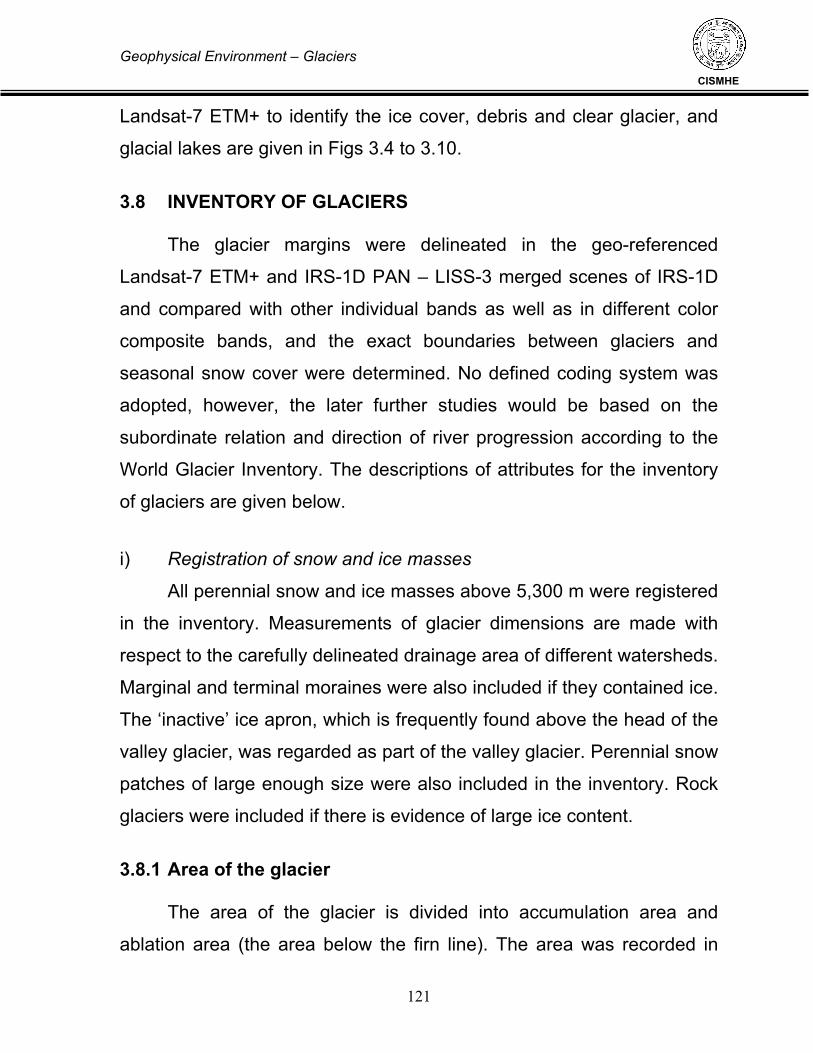
Geophysical Environment – Glaciers
121
CISMHE
Landsat-7 ETM+ to identify the ice cover, debris and clear glacier, and
glacial lakes are given in Figs 3.4 to 3.10.
3.8 INVENTORY OF GLACIERS The glacier margins were delineated in the geo-referenced
Landsat-7 ETM+ and IRS-1D PAN – LISS-3 merged scenes of IRS-1D
and compared with other individual bands as well as in different color
composite bands, and the exact boundaries between glaciers and
seasonal snow cover were determined. No defined coding system was
adopted, however, the later further studies would be based on the
subordinate relation and direction of river progression according to the
World Glacier Inventory. The descriptions of attributes for the inventory
of glaciers are given below.
i) Registration of snow and ice masses
All perennial snow and ice masses above 5,300 m were registered
in the inventory. Measurements of glacier dimensions are made with
respect to the carefully delineated drainage area of different watersheds.
Marginal and terminal moraines were also included if they contained ice.
The ‘inactive’ ice apron, which is frequently found above the head of the
valley glacier, was regarded as part of the valley glacier. Perennial snow
patches of large enough size were also included in the inventory. Rock
glaciers were included if there is evidence of large ice content.
3.8.1 Area of the glacier The area of the glacier is divided into accumulation area and
ablation area (the area below the firn line). The area was recorded in

Geophysical Environment – Glaciers
122
CISMHE
square kilometres. The delineated glacier area was digitized in the
‘GeoMedia Professional 5.2 and the database was used to calculate the
total area.
i) Length of the glacier
The length of the glacier was divided into three columns: total length, length of ablation, and the mean length. The total (maximum)
length refers to the longest distance of the glacier along the centreline.
The mean value of maximum lengths of glacier tributaries (or firn basins)
is the mean length.
ii) Mean width
The mean width was calculated by dividing the total area (sq km)
by the mean length (km).
iii) Orientation of the glacier The orientation of accumulation and ablation areas is represented
in eight cardinal directions (N, NE, E, SE, S, SW, W, and NW). Some of
the glaciers are capping just in the form of an apron on the peak, which
is inert and sloping in all directions, and is represented as ‘open’. The
orientations of both the areas (accumulation and ablation) are the same
for most of the glaciers.
iv) Elevation of the glacier Glacier elevation was divided into highest elevation (the highest
elevation of the crown of the glacier), mean elevation (the arithmetic
mean value of the highest glacier elevation and the lowest glacier
elevation), and lowest elevation.
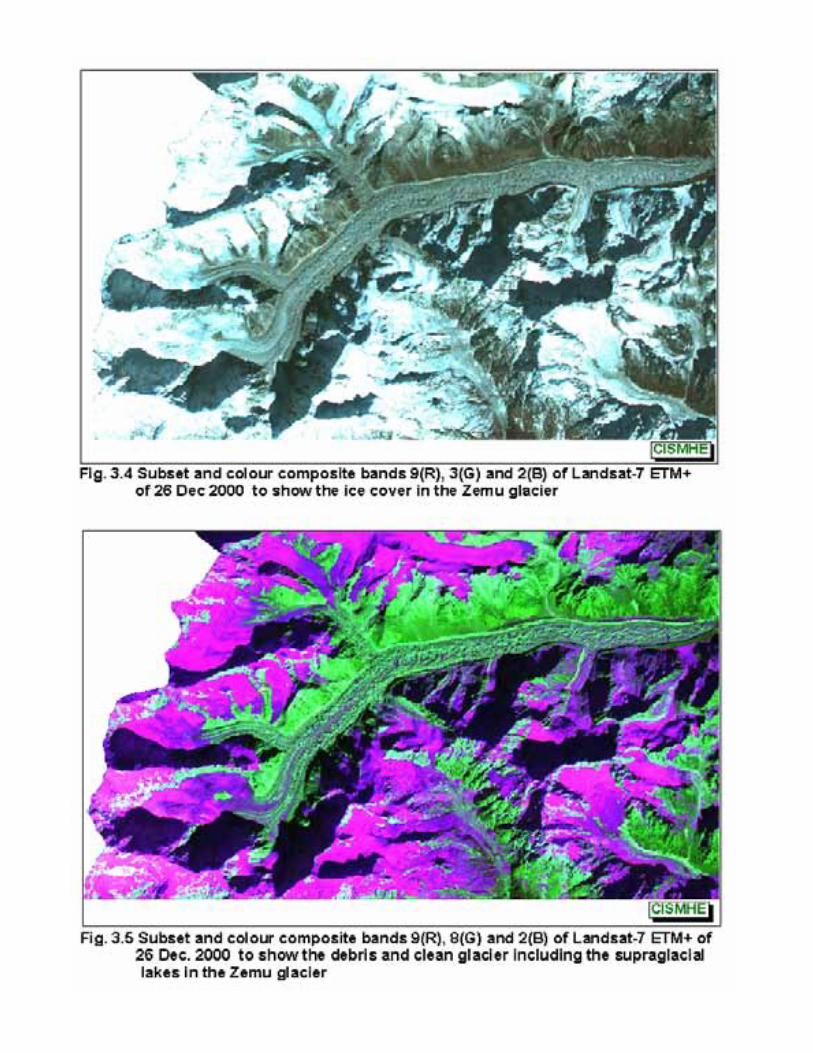

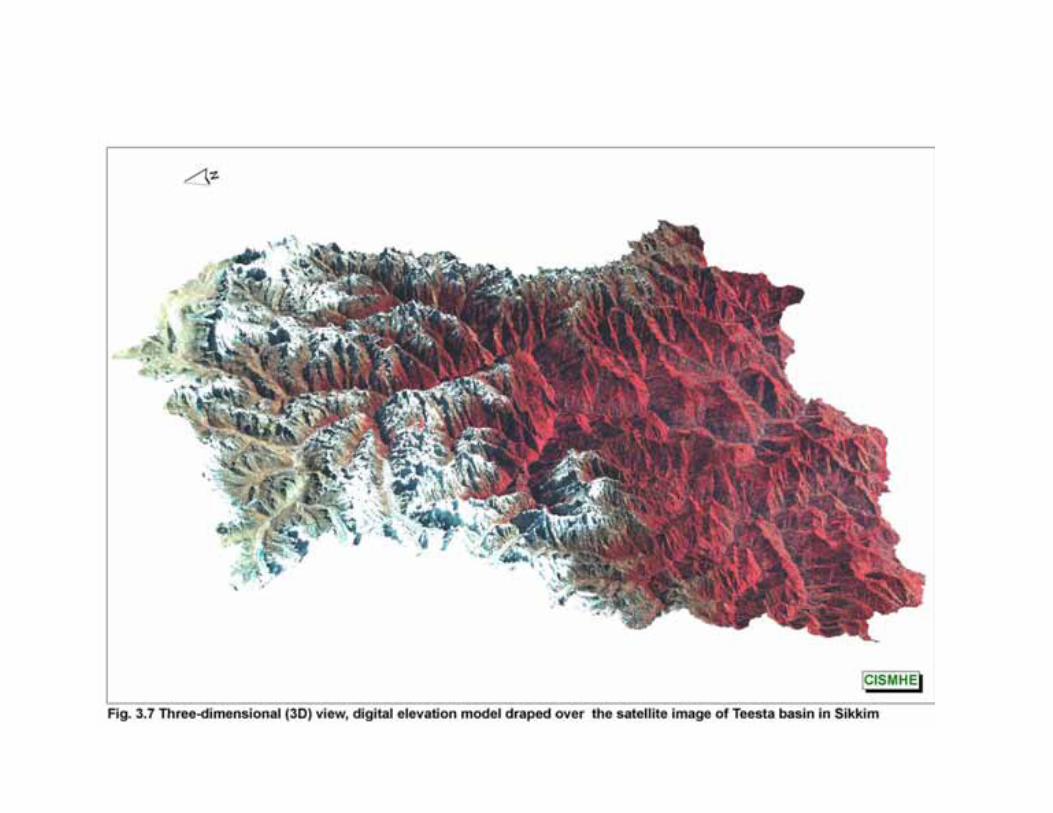


Geophysical Environment – Glaciers
123
CISMHE
3.9 INVENTORY OF GLACIAL LAKES
The glacial lakes on satellite image of IRS-1D PAN scenes,
Landsat-7 ETM+ of panchromatic mode and other individual bands of
both IRS-1D and Landsat-7 ETM+ and different colour combinations
were delineated and compared with other satellite images. All the glacial
lake boundaries are demarcated by screen digitizing in the
georeferenced satellite images of IRS-1D PAN scenes as well as
Landsat-7 ETM+ PAN image.
Rapid melting of big glaciers due to global climate changes in the
first half of 20th century has given rise to a number glacial lakes. In
recent times, due to the faster rate of ice and snow melting, the
accumulation of water in these lakes has been increasing rapidly.
Therefore, the isolated lakes above 3,500m are assumed to be the
remnants of the glacial lakes left due to the retreat of the glaciers.
The following characteristics of glacial lakes were recorded. i) Longitude and latitude Reference longitude and latitude are designated for the
approximate centre of the glacial lake by creating a digital point map
over the screen digitized glacial lakes.
ii) Area The area of the glacial lake was determined from the digital
database of the lake.

Geophysical Environment – Glaciers
124
CISMHE
iii) Length The length was measured along the long axis of the lake, and
represented in metre units.
iv) Width The width was calculated by dividing the area by the length of the
lake, down to two decimal place in hectare units.
v) Orientation The drainage direction of the glacial lake was specified as one of
eight cardinal directions (N, NE, E, SE, S, SW, W, and NW). For a
closed glacial lake, the orientation was specified according to the
direction of its longer axis.
vi) Altitude The altitude is registered by the water surface level of the lake in
metre.
3.9.1 Classification of lakes Genetically glacial lakes can be divided into the following. i) Glacial erosion lakes, including cirque lakes, trough valley lakes,
and erosion lakes
ii) Moraine-dammed lakes (also divided into neo end moraine and
paleo end moraine lakes), including end moraine lakes and lateral
moraine lakes

Geophysical Environment – Glaciers
125
CISMHE
iii) Blocking lakes formed through glaciers and other factors,
including the main glacier blocking the branch valley, the glacier branch
blocking the main valley, and the lakes formed through snow avalanche,
collapse, and debris flow blockade
iv) Ice surface and sub-glacial lakes 3.9.2 Stability Analysis
According to their stability, the glacial lakes are divided into three
types: stable, potential danger, and outburst (when there have been
previous bursts).
Glacial lakes are divided i.e. types of water drainage into drained
lakes and closed lakes according to the drainage condition. The former
refers to lakes from which water flows to the river and joins the river
system. In the latter, water does not flow into the river.
One important index for evaluating the stability of a glacial lake is its
contact relation with the glacier. So an item of distance from the upper
edge of the lake to the terminus of the glacier has been added and the
code of the corresponding glacier registered. Since an end moraine-
dammed lake is related to its originating glacier, this index is only referred
to end moraine-dammed lakes. As not enough field data exist, the
average depth of glacial lakes is difficult to establish in most cases.

Geophysical Environment – Glaciers
126
CISMHE
3.9.3 Types of Glaciers
Generally, six types of glacier were observed in the Sikkim
Himalaya—mountain glaciers, valley glaciers, cirque glaciers, niche
glaciers, ice caps, and ice aprons. The glaciers of uncertain or
miscellaneous compound basins, compound basin, or simple basin in
the form of a hanging glacier are considered as mountain glacier. The
major source of nourishment is snow and/or drift snow. Mountain
glaciers were dominant in distribution and the profile shows a hanging
nature. Other glaciers, except the valley glaciers are also a mountain
glacier, but differentiate as ice cap, cirque, niche, and ice apron. But the
thickness of ice of these glaciers is comparatively low. The number of
valley glaciers is comparatively low but the corresponding areas and ice
reserves are higher than those of mountain glaciers. If a valley glacier
continues up to a mountain glacier and is represented as a single unit,
then this part of the mountain glacier is also considered a valley glacier.
The area and ice reserves of the valley glaciers are generally large
owing to the fact that the ice thickness increases with increase in the
area of the glacier. Ice caps, cirque glaciers, niche glaciers, and ice
aprons are other types of hanging mountain glaciers, but they are
considered to be a different type due to their significance in size, shape,
form, and ice thickness. The most significant valley type glaciers are
fewer in number and characterized by compound basins, compound
basin, and simple basin. They are mainly nourished by snow and drift
snow at the headwaters and by snow and ice avalanches in the lower
valley. The adjoining part of the valley glacier at the headwater is

Geophysical Environment – Glaciers
127
CISMHE
characteristically a mountain glacier, but due to its continuation into a
valley glacier, the whole ice mass will be considered to be a valley
glacier. Hence, the area of the valley glacier is higher than the mountain
glaciers. The longitudinal profile of the valley glacier from crown to toe
shows an even or regular shape. As the headwater is steeper and has a
gentle slope in the lower reaches, the profile makes the curve concave
upwards. Due to the gentle slope at the lower reaches and the
accumulation of debris derived from the headwater, glacial lakes
develop in a supra- glacial and moraine-dammed lake. The stability of
such supra-glacial and moraine dammed glacial lakes is poor and there
is always chances of avalanches from mountain glaciers, which may
break the damming material and cause GLOFs.
3.10 GLACIERS OF SIKKIM HIMALAYA
The present inventory work is based on the IRS-1D LISS-3 scene,
PAN A-D scenes and Landsat-7 ETM+ scenes (see Fig. 3.4 – 3.10). The
glaciers of Sikkim Himalaya are distributed only in the upper reaches of
the Teesta basin. The glaciers of the Sikkim Himalaya extend from the
latitude of 27° 30’ to 28° 03’ 56” and the longitude of 88° 03’ 25” to 88°
53’ 26”. In all 271 glaciers could be delineated in the present study
covering an area of 518.97 sq km with an approximate ice reserve of
more than 60 km3 (Table 3.3, Fig. 3.11). However, as per the studies of
ICIMOD, there are 285 glaciers altogether covering an area of 576.433
sq km with an ice reserve of approximately 65 km3 (Table 3.4). Similar
on the basis satellite images of 1987-1989, Kulkarni and Narain (1990)

Geophysical Environment – Glaciers
128
CISMHE
reported that glaciers, cover an area of 426 sq km in Sikkim Himalaya,
whereas GSI studies (1999) reported the presence of 449 glaciers
covering an area of 705.54 sq km.
The glaciers of the Sikkim Himalaya are classified into Ice cap,
Valley glacier and Mounatin glacier. The mountain glaciers are further
classified into cirque, niche, and ice apron.
The number of mountain glaciers as per the recent studies of
ICIMOD, is highest (170) and other types of glaciers are less in number
as shown in the Table 3.3. For the classification of valley glaciers, the
headwater region of the valley glacier is a mountain glacier, while the
adjoining mountain glacier with a valley glacier is considered to be a
valley glacier. Hence the aerial extension of the valley glacier is very
high compared to other type of the glaciers as shown in the Table 3.3.
The ice caps, ice aprons, cirque glaciers, and niche glaciers have small
aerial extension with a thin ice sheet or ice thickness. The aerial
extension of these mountain glaciers are around 1% and the ice reserve
contributed by these glaciers are less than 1%. The glaciers on the
mountain slopes with the forms of miscellaneous, simple basin,
compound basin, and compound basins are higher in number and cover
161.67 sq. km of around 28%. The ice reserves contributed by these
glaciers are almost 14% in the Sikkim Himalaya (see Table 3.4).
The area occupied by the mountain glacier is generally high in
comparison to the other forms of mountain glacier. Again the area


Geophysical Environment – Glaciers
129
CISMHE
occupied by valley glaciers (68.65%) is quite high due to the addition of
the adjoining parts of the mountain glaciers. The valley glaciers cover
about 395.8 sq km with 68.65% of the ice reserve. Mountain glaciers
cover about 28% of the area and have 13.63% of the ice reserve. Other
types of glaciers cumulatively occupy 4% of the area and have less than
1% of the ice reserve.
Table 3.3 Glacier cover area inventory in Sikkim Himalaya Organisation Glacier cover (sq km) No. of glaciers
CISMHE (2000-2002) 518.97 270*
CISMHE (SOI Toposheets – 1970s) 661.50 N.A.
GSI (1970s) 705.54 449
ICIMOD (2000) 576.43 285
RRSSC, Nagpur (1998) 667.18 N.A.
SRSAC, 2001 691.00 281*
*This includes glaciers as well as permanent snow fields ypes of Glacier in the Sikkim Himalaya Table 3.4 Types of Glacier in the Sikkim Himalaya Types of Number Area Longest Shortest Ice reserve Glacier (km) (km) Count (%) (sq km) (%) (km3) (%) Mountain 170 59.65 161.67 28.04 8.57 0.02 8.8275 13.63 glaciers Niche glaciers 33 11.58 4.7 0.83 1.08 0.02 0.1168 0.18 Ice caps 25 8.77 6.27 1.09 1.18 0.04 0.1885 0.29 Valley glaciers 22 7.72 395.80 68.65 107.31 3.47 55.4176 85.55 Cirque glaciers 18 6.32 3.15 0.55 0.72 0.03 0.0766 0.12 Ice aprons 17 5.96 4.85 0.84 1.02 0.03 0.1525 0.24 Total 285 576.51 64.7795
Source: ICIMOD
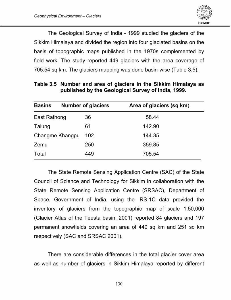
Geophysical Environment – Glaciers
130
CISMHE
The Geological Survey of India - 1999 studied the glaciers of the
Sikkim Himalaya and divided the region into four glaciated basins on the
basis of topographic maps published in the 1970s complemented by
field work. The study reported 449 glaciers with the area coverage of
705.54 sq km. The glaciers mapping was done basin-wise (Table 3.5).
Table 3.5 Number and area of glaciers in the Sikkim Himalaya as published by the Geological Survey of India, 1999.
Basins Number of glaciers Area of glaciers (sq km)
East Rathong 36 58.44
Talung 61 142.90
Changme Khangpu 102 144.35
Zemu 250 359.85
Total 449 705.54
The State Remote Sensing Application Centre (SAC) of the State
Council of Science and Technology for Sikkim in collaboration with the
State Remote Sensing Application Centre (SRSAC), Department of
Space, Government of India, using the IRS-1C data provided the
inventory of glaciers from the topographic map of scale 1:50,000
(Glacier Atlas of the Teesta basin, 2001) reported 84 glaciers and 197
permanent snowfields covering an area of 440 sq km and 251 sq km
respectively (SAC and SRSAC 2001).
There are considerable differences in the total glacier cover area
as well as number of glaciers in Sikkim Himalaya reported by different

Geophysical Environment – Glaciers
131
CISMHE
organization at different periods of time. One reason for this is the
difference in the year of satellite data used as the satellite data of earlier
years i.e. between 1970 and 1990 is of low resolution of about 76 m x
76m pixel size (Fig. 3.12), whereas the satellite data of later years is of
much better resolution i.e. with pixel resolution of up to 5.6 m. Therefore,
the decrease in glacier cover is partially due to data quality and also
may be due to glacial melting. Generally low resolution satellite images
of 1980s and early 1999s, has resulted in reporting or more area under
glacier cover because due to lower resolution, it is difficult to differentiate
glaciers from the adjacent landcover with accuracy, thereby resulting in
more glacier cover. Moreover, the data set of November-December
months only, gives the realistic picture of the glacier spread. However,
for better understanding of the glacier cover over the years, had to be
undertaken by these agencies/ organizations together after pooling their
resources and adopting the common and universal methodologies.
On the basis of satellite data of IRS-1B LISS-II of 1990, Jeyaram
et al. (1998) at RRSSC, Nagpur reported 65 glaciers covering an area of
667.18 sq km of Sikkim Himalaya and divided the glaciers of Teesta
basin in Sikkim in to seven glacier complexes viz. Chhombo, Yumthang,
Lambgo, Zemu, Talong, Rathong and Rel glacier complexes.
3.10.1 Zemu Glacier The Zemu glacier is the largest and longest glacier in the Sikkim
Himalaya, which occupies an area of around 107 sq km. The mean
length of the glacier is around 25.7 km with an ice reserve of 22 km3.
The crown and toe of the glacier ranges from 7,790 m to 4,070 m. The

Geophysical Environment – Glaciers
132
CISMHE
glacier flows from the eastern aspect of the Mt Khangchendzonga ridge,
which separates it from Nepal. The Zemu glacier flows as a valley
glacier flows from west to east with many minor glaciers from other
directions (Fig. 3.13). The major tributaries of the Zemu glacier are some
parts of the Hidden glacier, Tent peak glacier, Nepal gap glacier, Twin
glacier, Passaram glacier and Simvo glacier.
The glacier extends from 8,000 m to 4,000 m with an elevation
difference of 4,000 m along a distance of about 55 km. The elevation
rises abruptly within the distance of 10 km from the crown of the Zemu
glacier. The equilibrium line lies at round 6,000 m. As the glacier is
valley type, the length of the ablation is less than 8 km, whereas the
length of the accumulation is around 50 km. The profile of Zemu glacier
shows that the ablation part is very steep whereas the accumulation part
is gentler. The equilibrium line area shows an upward curve convex
whereas the overall curve shows upward concave indicating the maturity
of the profile.
3.10.2 Glacial Lakes of Sikkim Himalaya The inventory of glacial lakes is based on the satellite images of
Landsat-7 ETM+ and IRS-1D LISS-3 & PAN. The identified glacial lakes
are delineated and inventorised mainly from the merged satellite LISS-3
and PAN scenes of IRS-1D. Some of the important glacial lakes could
not be mapped from the topographic maps (see Figs 3.9 and 3.11), so
instead of mapping from the SOI topographic maps the glacial lakes
were mapped from the satellite data and were verified and confirmed


Geophysical Environment – Glaciers
133
CISMHE
from different individual bands as well as by combining the different
possible colour composite bands. The colour composite bands of 4,3,2,
9,8,2, and 9,3,2 were found useful and easy to differentiate between the
rock outcrop and glacier, clean glacier and debris glacier, snow and
cloud, and identification of lake. The lakes and glaciers were further
confirmed from the images of individual bands as well as with the
combination of bands of IRS-1D LISS-3 and also from band ratioing of
band 3 – band 2/ band 3 + band 2 (Fig. 3.14). The cloud free satellite
images used in the study are of 06 December 2000 (Landsat-7 ETM+)
and November, 2002 (IRS-1D).
The lakes associated with perennial snow and ice originates from
glaciers. But the isolated lakes found in the mountains and valleys far
from the glaciers may not have a glacial origin. The lakes are classified
into erosion lakes, valley trough lakes, cirque lakes, blocked lakes,
lateral and end moraine-dammed lakes, and supraglacial lakes.
3.10.3 Erosion lakes Glacial erosion lakes are the water bodies formed in a depression
after the glacier has retreated. They are stable lakes. Most of these
erosion lakes might have formed in the past glacial ice age and are
isolated and far away from the present glaciers (Figs 3.15 & 3.16).
3.10.4 Trough valley lakes The lakes, which are formed along the river valley due to eruption,
are known as valley trough lakes. Generally these lakes are formed in

Geophysical Environment – Glaciers
134
CISMHE
the wide and deep trough along the river due to glacial erosion. These
lakes are located in the downstream of the glacier. Any change in the
mother glacier will impact the valley trough lake downstream. The lake
Khora Chho, Chhora Chhobuk and Tso Chhobek shown in Fig. 3.17 are
trough valley type lakes in the Sikkim Himalaya.
3.10.5 Cirque lakes Cirque lakes are formed in separate, rounded, steep-walled recess
on a mountain due to the glacial erosion. Generally the cirque lakes are
smaller in size.
3.10.6 Blocked lakes Blocking lakes formed due to glaciers and other factors, including
the main glacier blocking the branch valley (Fig. 3.18), the glacier
branch blocking the main valley, and the lakes formed through snow
avalanche, collapse, and debris flow blockade from main or branch
valley. The two lakes located on either side of the Choktsering Chhu
glacier are formed due to the blocking by the moraine of the glacier.
3.10.7 Supra-glacial lakes
The supra-glacial lakes are small and change their position in the
glacier. The history of past GLOF events of moraine-dammed lakes
indicates that they are initially derived from supra-glacial lakes. If supra-
glacial lakes are situated at the toe of a valley glacier, larger in size, or
grouping rapidly to expand their size, then they are potentially dangerous


Geophysical Environment – Glaciers
135
CISMHE
and may burst out in the near future. The supra-glacial lakes develop
within the ice mass away from the moraine with dimensions of 50 to 100m.
These lakes may develop in any position of the glacier but the extension of
the lake is less than half the diameter of the valley glacier. Shifting,
merging, and draining of the lakes characterised the supra-glacial lakes.
The merging of lakes results in expansion of the lake area and storage of a
huge volume of water with a high potential energy. The tendency of a
glacial lake towards merging and expanding indicates the danger level of
GLOF. Group of supra-glacial lakes are formed in the northwestern part of
the Sikkim Himalaya as shown in the Figure 3.19.
3.10.8 Moraine-dammed lakes n the retreating process of a glacier, glacier ice tends to melt in the
lowest part of the glacier surrounded by lateral and end moraines. As a
result, many supra-glacial ponds are formed on the glacier tongue. These
ponds sometimes enlarge to become a large lake by interconnecting with
each other and have a tendency to deepen further. A moraine dammed
lake is thus born. The lake is filled with melt water and rainwater from the
drainage area behin d the lake and starts flowing from the outlet of the
lake even in the winter season when the flow is minimum. There are so
many moraine-dammed lakes in the Sikkim Himalaya and one example of
the moraine-dammed lake, which is formed on the tongue of the glacier is
depicted in Figs 3.16, 3.19 and 3.20.
There are two types of moraine: an ice-cored moraine and an ice-
free moraine. Before the ice body of the glacier completely melts away,

Geophysical Environment – Glaciers
136
CISMHE
glacier ice exists in the moraine and beneath the lake bottom. The ice
bodies cored in the moraine and beneath the lake are sometimes called
dead ice or fossil ice. As glacier ice continues to melt, the lake
becomes deeper and wider. Finally, when the ice contained in the
moraines and beneath the lake completely melts away; it contains only
the bedrock and the moraines.
3.10.9 Ice-dammed lakes
An ice-dammed lake is produced on the side(s) of a glacier, when an
advancing glacier happens to intercept a tributary/tributaries pouring into a
main glacier valley. A glacial lake is formed and maintained only up to a
certain stage of glacier fluctuation. If one follows the lifespan of an individual
glacier, it is found that the moraine-dammed glacial lakes build up and
disappear with the lapse of time. The moraine-dammed lakes disappear
once they are fully destroyed or when debris fills the lakes completely or the
mother glacier advances again to lower altitudes beyond the moraine-dam
position. Such glacial lakes are essentially ephemeral and are not stable
from the point of view of the life of glaciers. 3.10.10 Inventory and Characteristics
The glacial lakes of the Sikkim Himalaya extend from the latitude
of 27° 30’ to 28° 03’ 56” and the longitude of 88° 03’ 25” to 88° 53’ 26”.
There are altogether 313 glacial lakes throughout the Teesta basin of
the Sikkim Himalaya covering an area of 21.5 sq km (see Annexure-I).

Geophysical Environment – Glaciers
137
CISMHE
The number of glacial lakes in the Sikkim Himalaya as reported by
ICIMOD in 266 covering an area of 20.2 sq km (Table 3.6). The largest
number (153) of glacial lakes are erosion lakes. There are 43 moraine-
dammed lakes; among which one is a lateral moraine dammed lake.
There are 33 valley lakes, 19 cirque lakes, 15 blocked lakes and 3
supra-glacial lakes. There are other supra-glacial lakes in the moraine of
the glaciers, which are mostly frozen and some of it are quite small in
size to map. In general, the erosion lakes are isolated and far away from
the glaciers, moraine dammed lakes are close and associated with the
present glaciers, valley trough lakes are situated along the river valley
floor and some of it are quite close to the glacier end, blocked lakes are
formed due to landslide, ice avalanche, etc. from different valleys, and
the supraglacial lakes are situated in groups within the ice mass.
Table 3.6 Types of glacial lakes in the Sikkim Himalaya
Types of lake Number Area Largest Lake Count % (km2) (%) Blocked 15 5.64 1.56 7.72 0.65
Cirque 19 7.14 1.23 6.09 0.35 Erosion 153 57.52 6.04 29.90 0.26
Lateral moraine 1 0.38 0.01 0.05 0.01
Dammed End moraine 42 15.79 7.50 37.13 1.59
Supraglacial 3 1.13 0.07 0.35 0.03
Valley 33 12.41 3.79 18.76 1.06
Total 266 20.2
Source: ICIMOD
More than 70% of the lake area is covered by erosion lakes and
moraine-dammed lakes. The valley trough lake, blocked lake, cirque

Geophysical Environment – Glaciers
138
CISMHE
lake, and supra-glacial lakes occupy around 19%, 8%, 6% and 0.35%,
respectively. The total area occupied by the lakes is around 3.8 sq km,
which is around 0.054% of the total land cover (7,096 sq km) of the
Sikkim Himalaya.
The largest glacial lakes in the Sikkim Himalaya are the moraine
dammed Khangchung Chho lake and the Gurudongmar Chho lake 1,
which cover an area of about 1.64 sq km and 1.08 sq km, respectively
(Fig. 3.21). Both of these largest lakes flow toward the north.
The long dimension of the glacial lakes in the Sikkim Himalaya is
distributed randomly in all cardinal directions. The majority of glacial
lakes face towards the southwest. Few glacial lakes are also draining
towards the east and north. The largest glacial lake with an area more
than 1.5 sq km is draining towards northwest. The other large lake,
which has an area of more than one sq km is draining towards the north
(Table 3.7).
Table 3.7 Distribution of number and area with respect to the
aspect of the lakes
Orientation Area Number Longest Largest (km2) (metre) (km2)
East 1.50 14 1500 0.59 North 2.74 15 2680 1.07 Northeast 2.42 28 1750 0.65 Northwest 3.17 31 3050 1.59 South 1.96 41 1680 0.57 Southeast 2.72 40 1500 0.37 Southwest 4.22 74 1785 0.47 West 1.47 23 1030 0.28 Total 20.2 266

Geophysical Environment – Glaciers
139
CISMHE
The number of glacial lakes are maximum in Chhombo Chhu
watershed i.e. 69 covering lake area of 8.56 sq km. Incidently two of the
largest lakes, Khangchung Chho – the source of Teesta river and
Gurudongmar Chho are located in this source watershed of Teesta river
(Fig. 3.22). Yumthang Chhu watershed has 59 ha (0.50 sq km). Majority
of the glacial lakes are located in the altitudinal range of 4,000 m to
5,000 m, i.e. more than 62% of the lakes (196 in number out of total 316
lakes) are located in this elevation range (Fig. 3.23). However, 99 lakes
are located above 5,000 m, with lake area ranging from 0.09 ha to
164.24 ha (1.64 sq km). Four largest lakes with area more than
Khangchung Chho, Gurudongmar Lake 1, Gurudongmar Lake 2 and
Chho Lhamo. The last three mentioned drain toward north.
3.11 MAJOR LAKES Sikkim is very small in area even though there are many lakes and
most of it are fed by glaciers and considered as sacred and holy lakes.
They generally remain snow covered during winter season (Roy and
Thapa, 1998). The lakes are popularly called as Chhokha or Tso or
Chhona (in Bhutia), Chho (in Lepcha) and Pokhari or Jheel or Tal (in
Nepali).
i) Chhangu (Tsomgo) Lake It is situated at an altitude of 3,660 m on the Gangtok-Nathu La
Highway about 40 km away from Gangtok. The lake is oval in shape,
about 1 km long, and 15 metres deep and is considered sacred by the
local people. This lake remains frozen during the winter months till mid-
May.

Geophysical Environment – Glaciers
140
CISMHE
ii) Menmoi Chho The Menmoi Chho lake is around 0.22 sq km in area and 650 m
long. It is formed along the valley and is located about 20 km before
Chhangu lake. It lies between the mountains below the Jelepla Pass.
The lake is fed by melting snow and ice and the source of the Rangpo
Chhu. The lake is also famous for trout fish farming.
iii) Khecheopalri Lake The lake is around 0.067 sq km in area and 370 m long situated in the
center of the dense forest. The lake is cirque type and is considered as one
of the most sacred lakes by the Sikkimese people both by the Buddhists
and the Hindus (Jain et al. 1999 and 2000 and Jain, 2000). It is accessible
by a motorable road from Pemayangtse right up to the lake area.
iv) Green Lake Green lake is formed due to the damming of the left lateral
moraine of the Zemu glacier. The hollow enclosed between the covering
moraines of Zemu and the Green Lake does not exist anymore in the
form of a lake but in the form of the remnant of the lake basin.
v) Samiti Lake It is around 0.02 sq km in area and 200 m long. This lake is also of
glacial origin and lies in the Onglakthang valley. It is clearly visible from
the Geochala Pass.
vi) Chho Lhamo Lake This is blocked type lake, with an area of about 1.04 sq km and
11,750 m long. It is situated on the plateau close to the border of Sikkim

0
10
20
30
40
50
60
70
80
RangpoChhu
YumthangChhu
Chhombo Chhu
Zemu Chhu
Rathong Chhu
RangyoungChhu
Prek Chhu Lachen Chhu
LachungChhu
Dik Chhu Rel Chhu
Watersheds
No.
of L
akes
0
100
200
300
400
500
600
700
800
900
Are
a of
Lak
es (h
a)
No. of Lakes Area of Lakes (ha)
Fig. 3.22 Number and area (ha) of glacial lakes in different watersheds of Teesta basin in Sikkim

1 1 1
7
2
64
19
24
42
17
6
10
37
4
20
14
2
35
27
37
0
5
10
15
20
25
30
35
40
45
RangpoChhu
YumthangChhu
ChhomboChhu
Zemu Chuu
Rathong Chhu
Rangyoung Chhu
Prek Chhu Lachen Chhu
Lachung Chhu
Dik Chhu Rel Chhu
Sub-watersheds
No. o
f Lak
es
Below 3500m 3500-4000m 4000-5000m above 5000m
Fig. 3.23 Distribution of glacial lake in various altitudinal zones in different watersheds of Teesta basin in Sikkim
Geophysical Environment – Glaciers
141
CISMHE
and Tibet in Chhombo Chhu watershed, the source watershed of Teesta
river, China. The lake is of glacial origin and feed the Teesta river. The
lake water is frozen during winter.
vii) Gurudongmar Chho 1 It is one of the largest lake with an area of about 1.09 sq km and
1.8 km long. It is the north flowing moraine dammed lake and one of the
potentially dangerous glacial lakes in the Sikkim Himalaya.
viii) Dalle Lake It is typically rounded in shape and named as Dalle Lake. This is
Cirque type with an area of around 0.017 sq km and 100 m long.
ix) Lam Pokhari It is elongated in shape and named as Lam Pokhari (Lake). This is
Erosion type with an area of around 0.10 sq km and 600 m long.
x) Lachhmi Pokhari This is Cirque type Lake with an area of around 0.16 sq km and
450 m long.
xi) Chhangu (Tsomgo) Lake This is Erosion type Lake with an area of around 0.23 sq km and
985 m long.
3.11.1 Glacial Lake Outburst Floods Periodic or occasional release of large amounts of stored water in
a catastrophic outburst flood is widely referred to as a Glacial Lake

Geophysical Environment – Glaciers
142
CISMHE
Outburst Flood in the Himalaya. GLOF is a catastrophic discharge of
water under pressure from a glacier. GLOF events are severe geo-
morphological hazards and their floodwaters can wreak havoc on all
human structures located on their path. Much of the damage created
during GLOF events is associated with the large amounts of debris that
accompany the floodwaters. Damage to settlements and farmland can
take place at very great distances from the outburst source, for example,
in Pakistan the damage occurred 1,300 km from the outburst source
(WECS 1987).
3.11.2 Causes of Lake Creation i) Global warming
There is a growing concern that human activities may change the
climate of the globe. Past and continuing emissions of carbon dioxide
(CO2) and other gases will cause the temperature of the earth’s surface
to increase- this is popularly termed ‘global warming’ or the ‘greenhouse
effect’. The ‘greenhouse effect’ gives an extra temperature rise.
ii) Glacier retreat
An important factor in the formation of glacial lakes is the rising
global temperature (‘greenhouse effect’), which causes glacial retreat in
many mountain regions. During the so-called ‘Little Ice Age’ (AD 1550–
1850), many glaciers were longer than today. Moraines formed in front
of the glaciers at that time block the lakes nowadays. Glaciation and
inter-glaciation are natural processes that have occurred several times
during the last 10,000 years.

Geophysical Environment – Glaciers
143
CISMHE
As a general rule, it can be said that glaciers in the Himalaya have
retreated about one km since the Little Ice Age, a situation that provides
a large space for retaining melt water, leading to the formation of
moraine-dammed lakes (LIGG/WECS/NEA 1988). Röthlisberger and
Geyh (1985) conclude in their study on ‘glacier variations in the
Himalaya and Karakorum’ that a rapid retreat of nearly all glaciers with
small oscillation was found in the period from 1860/1900–1980.
3.11.3 Causes of Glacial Lake Water Level Rise
The causes of rise in water level in the glacial lake dammed by
moraines that endanger the lake to reach a breaching point are given
below.
• Rapid change in climatic conditions that increase solar radiation
causing rapid melting of glacier ice and snow with or without the
retreat of the glacier
• Intensive precipitation events
• Decrease in sufficient seepage across the moraine to balance the
inflow because of sedimentation of silt from the glacier runoff,
enhanced by the dust flow into the lake
• Blocking of ice conduits by sedimentation or by enhanced plastic
ice flow in the case of a glacial advance
• Thick layer of glacial ice (dead ice) weighed down by sediment
below the lake bottom, which stops subsurface infiltration or
seepage from the lake bottom.

Geophysical Environment – Glaciers
144
CISMHE
• Shrinking of the glacier tongue higher up, causing melt water that
previously left the glacier somewhere outside the moraine, where it
may have continued underground through talus, not to follow the
path of the glacier
• Blocking of an outlet by an advancing tributary glacier
• Landslide at the inner part of the moraine wall, or from slopes
above the lake level
• Melting of ice from an ice-core moraine wall
• Melting of ice due to subterranean thermal activities (volcanogenic,
tectonic)
• Inter-basin sub-surface flow of water from one lake to another due
to height difference and availability of flow path
3.11.4 Bursting Mechanisms
Different triggering mechanisms of GLOF events depend on the
nature of the damming materials, the position of the lake, the volume of
the water, the nature and position of the associated mother glacier,
physical and topographical conditions, and other physical conditions of
the surroundings.
3.11.5 Mechanism of Ice Core-Dammed Lake failure
Ice-core dammed (glacier-dammed) lakes drain mainly in two ways.
• through or underneath the ice
• over the ice

Geophysical Environment – Glaciers
145
CISMHE
Initiation of opening within or under the ice dam (glacier) occurs in six
ways.
• Flotation of the ice dam (a lake can only be drained sub-glacially if
it can lift the damming ice barrier sufficiently for the water to find its
way underneath)
• Pressure deformation (plastic yielding of the ice dam due to a
hydrostatic pressure difference between the lake water and the
adjacent less dense ice of the dam; outward progression of cracks
or crevasses under shear stress due to a combination of glacier
flow and high hydrostatic pressure)
• Melting of a tunnel through or under the ice
• Drainage associated with tectonic activity
• Water overflowing the ice dam generally along the lower margin
• Sub-glacial melting by volcanic heat
The bursting mechanism for ice core-dammed lakes can be highly
complex and involve most or some of the above-stated hypothesis.
Marcus (1960) considered ice core-dammed bursting as a set of
interdependent processes rather than one hypothesis. A landslide
adjacent to the lake and/ or subsequent partial abrasion on ice may lead
to overtopping as the water flows over, the glacier retreats, and the lake
fills rapidly, which may subsequently result in the draining of ice core
moraine-dammed lakes.

Geophysical Environment – Glaciers
146
CISMHE
3.11.6 Mechanisms of Moraine-Dammed Lake failure
Moraine-dammed lakes are generally drained by rapid incision of
the sediment barrier by outpouring waters. Once incision begins, the
hustling water flowing through the outlet can accelerate erosion and
enlargement of the outlet, setting off a catastrophic positive feedback
process resulting in the rapid release of huge amounts of sediment-
laden water. The onset of rapid incision of the barrier can be triggered
by waves generated by glacier calving or ice avalanching, or by an
increase in water level associated with glacial advance (examples
include an ice avalanche from Langmoche Glacier on 4 August 1985
and another on 3 September 1998 from Sabai Glacier).
Dam failure can occur due to the following reasons:
• melting ice core within the moraine dam,
• rock and/or ice avalanche into a dammed lake,
• settlement and/or piping within the moraine dam,
• sub- glacial drainage, and
• engineering works.
3.11.7 Surge Propagation
As GLOFs pose severe threats to humans and man-made
structures, it is important to make accurate estimates of the likely
magnitude of future floods. Several methods have been devised to
predict peak discharges, which are the most erosive and destructive

Geophysical Environment – Glaciers
147
CISMHE
phases of floods. The surge propagation hydrograph depends upon the
type of GLOF event, i.e. from moraine-dammed lake or from ice-
dammed lake.
3.11.8 Sediment Processes during a Glacial Lake Outburst Flood
During a GLOF, the flow velocity and discharge are exceptionally
high and it becomes practically impossible to carry out any
measurement.
3.11.9 Socio-economic effects of Glacial Lake Outburst Floods
The impact of a GLOF event downstream is quite extensive in
terms of damage to roads, bridges, trekking trials, villages, and
agricultural lands as well as the loss of human lives and other
infrastructures. The sociological impacts can be direct when human lives
are lost, or indirect when the agricultural lands are converted to debris
filled lands and the village has to be shifted. The records of past GLOF
events show that once every three to ten years, a GLOF has occurred in
Nepal with varying degrees of socio-economic impact. Therefore, proper
hazard assessment studies must be carried out in potentially
problematic basins to evaluate the likely economic loss and the most
appropriate method of mitigation activities.
The assessment of tangible benefits in respect to mitigation of
GLOFs is, however, difficult. Reduced damage is considered a benefit

Geophysical Environment – Glaciers
148
CISMHE
and can be quantified, but the frequency of the reduced damage is
difficult to ascertain due to lack of data. One cannot simply predict the
timing and occurrences of GLOFs. It is extremely difficult to simulate
numerically the flood level and velocities at a particular place.
At this stage, from brief studies of GLOFs throughout the world, it
appears that there are no simple direct means of estimating the
recurrence of GLOFs.
3.11.10 Potentially Dangerous Glacial Lakes
From an inventory of glacial lakes, on the basis of remote sensing
satellite images, the spatial and attribute database is developed. The
potentially dangerous glacial lakes were identified on the basis of
attribute database in relation to the mother glacier and other criteria. In
addition to the other factors, detailed geomorphic studies, type of the
glacial lake, size of the lake, and the relation of lakes with the mother
glacier are the prime factors for the identification of potentially
dangerous glacial lakes. In general, based on geo-morphological
characteristics, glacial lakes can be grouped into three types: glacial
erosion lakes, glacial cirque lakes, and moraine-dammed lakes. The
former two types of glacial lakes occupy the lowlands or emptying
cirques eroded by ancient glaciers. These glacial lakes are more or less
located away from present-day glaciers and the downstream banks are
usually made of bedrock or covered with a thinner layer of loose
sediment. Both of these glacial lakes do not generally pose an outburst
danger. On the other hand, the moraine-dammed glacial lakes have the
Geophysical Environment – Glaciers
149
CISMHE
potential for bursting. A standard index to define a lake that is a source
of potential danger because of possible bursting does not exist.
Moraine-dammed glacial lakes, which are still in contact or very
near to the glaciers, are usually dangerous. The present study defines
all the lakes formed by the activity of glaciers including in the past as
‘glacial lakes’. Moraine-dammed glacial lakes are usually dangerous.
These glacial lakes were partly formed between present-day glaciers
and Little Ice Age moraine. The depositions of Little Ice Age moraines
are usually about 300 years old, form high and narrow arch-shaped
ridges usually with a height of 20-150 m and often contain dead glacier
ice layers beneath them. These end moraines are loose and unstable in
nature. The advance and retreat of the glacier affect the hydrology
between the present-day glacier and the lake dammed by the moraines.
Sudden natural phenomena with a direct effect on a lake, like ice
avalanches or rock and lateral moraine material collapsing on a lake,
cause moraine breaches with subsequent lake outburst events. Such
phenomena have been well known in the past in several cases of
moraine-dammed lakes, although the mechanisms at play are not fully
understood.
3.11.11 Criteria for Identification The criteria for identifying the potentially dangerous glacial lakes
are based on field observations, processes and records of past events,
geo-morphological and geo-technical characteristics of the lake and
surroundings, and other physical conditions. The potentially dangerous

Geophysical Environment – Glaciers
150
CISMHE
lakes were identified based on the condition of lakes, dams, associated
mother glaciers, and topographic features around the lakes and glaciers.
i) Rise in lake water level In general, the lakes, which have a volume of more than 0.01 km3
are found to have past events. A lake, which has a larger volume than
this, is deeper, with the deeper part near the dam (lower part of lake)
rather than near the glacier tongue, and has rapid increase in lake water
volume is an indication that a lake is potentially dangerous.
ii) Activity of Supra-glacial Lakes Groups of closely spaced supra-glacial lakes of smaller size at
glacier tongues merge as time passes and form bigger lakes in Zemu
glacier, which is associated with many supra-glacial lakes.
The Sikkim Himalaya also, has many such types of supra-glacial
lakes in the form of groups (see Fig. 3.19). The supraglaical lakes are
more distinct and sufficiently large enough and eventually it will merge to
form a large lake of potential danger.
iii) Position of Lakes
The potentially dangerous lakes are generally at the lower part of
the ablation area of the glacier near to the end moraine, and the mother
glacier should be sufficiently large to create a potentially dangerous lake
environment. Regular monitoring needs to be carried out for such lakes
with the help of multi- temporal satellite images, aerial photographs, and
field observations.

Geophysical Environment – Glaciers
151
CISMHE
In general, the potentially dangerous status of moraine-dammed
lakes can be defined by the conditions of the damming material and the
nature of the mother glacier. The valley lakes with an area bigger than
0.1 sq km and a distance less than 0.5 km from the mother glacier of
considerable size are considered to be potentially dangerous. Cirque
lakes even smaller than 0.1 sq km associated (in contact or distance
less than 0.5 km) with steep hanging glaciers are considered to be
potentially dangerous. Even the smaller size steep hanging glacier may
pose a danger to the lake.
iv) Dam conditions The natural conditions of the moraine damming the lake determine
the lake stability. The lake stability will be less if the moraine dam has a
combination of the following characteristics:
• narrower in the crest area
• no drainage outflow or outlet not well defined
• steeper slope of the moraine walls
• ice cored
• very tall (from toe to crest)
• mass movement or potential mass movement in the inner slope
and/or outer slope
• breached and closed in the past and refilled again with water
• seepage flow at moraine walls
A moraine-dammed lake, which has breached and closed
subsequently in the past and has refilled again with water, can breach

Geophysical Environment – Glaciers
152
CISMHE
again. Lhonak Chho in the north-west of Sikkim burst out (Fig. 3.24).
The study of recent aerial photographs and satellite images shows a
very quick regaining of lake water volume. At present it is refilled again
with water and poses danger. Regular monitoring of such lakes is
necessary using multi-temporal satellite images.
Although there are no reports on the GLOF events in the Sikkim
Himalaya, many debris flow along the glacial lake valley are seen in the
satellite images. The erosion and deposition of debris along the valley
can be seen clearly from the satellite images.
v) Condition of Associated Mother Glacier
Generally, the bigger valley glaciers with tongues reaching an
elevation of below 5,000 m have well-developed glacial lakes. Even the
actively retreating and steep hanging glaciers on the banks of lakes may
be a potential cause of danger. The following general characteristics of
associated mother glaciers can create danger to moraine-dammed
lakes:
• hanging glacier in contact with the lake,
• bigger glacier area,
• fast retreating,
• debris cover at glacier tongue area,
• steep gradient at glacier tongue area,
• presence of crevasses and ponds at glacier tongue area,
• toppling/collapses of glacier masses at the glacier tongue,
• ice blocks draining to lake, and

Geophysical Environment – Glaciers
153
CISMHE
• hanging glacier in contact with the lake
vi) Physical conditions of the surroundings Besides moraines, mother glaciers, and lake conditions, and other
physical conditions of the surrounding area as given below may also
cause the lake to be potentially dangerous:
• potential rockfall/slide (mass movements) site around the lake
which can fall into the lake suddenly,
• snow avalanches of large size around the lake which can fall into
the lake suddenly,
• neo-tectonic and earthquake activities around or near the lake
area,
• climatic conditions of successive years being a relatively wet and
cold year followed by a hot and wet or hot and arid year,
• very recent moraines damming the lake at the tributary glaciers
that used to be just a part of a former complex of valley glacier
middle moraines as a result of the fast retreat of a complex mother
valley glacier, and
• sudden advance of a glacier towards the lower tributary or the
mother glacier having a well-developed lake at its tongue
3.11.12 Major Glacial Lakes Associated with the Glaciers
For identification of potentially dangerous glacial lakes, the glacial
lakes associated with glaciers like supra-glacial lakes and/or dammed by
lateral moraine or end moraine with an area larger than 0.02 sq km have

Geophysical Environment – Glaciers
154
CISMHE
been considered and they have been defined as major glacial lakes. The
area of the inventorised glacial lakes is larger than 0.003 sq km. There are
266 such glacial lakes in the Sikkim Himalaya. Among these glacial lakes,
55 of them have an area that is larger than 0.02 sq km and less than 1.4
km distance from the mother glacier. Twentyfour (24) major glacial lakes
are in contact with or within the glacier, 19 glacial lakes are within the
distance of 500 and the rest is within the distance of 1,400 m (Table 3.8).
Table 3.8 Major glacial lakes of Teesta basin in Sikkim Sl. Latitude and Longitude Lake Class Area Dist. from No. Name (sq m) glacier (m) 1. 27°32’01.48"N, 88°05’15.33"E ? Moraine-dammed 2,90,742 0
2. 27°33’52.64"N, 88°07’30.82"E ? Valley 99,727 500
3. 27°29’46.27"N, 88°14’11.89"E ? Blocked 33,086 1125
4. 27°42’40.05"N, 88°23’09.78"E ? Erosion 32,859 58
5. 27°45’36.69"N, 88°29’13.26"E Lamgepui Cho Moraine-dammed 99,114 0
6. 27°45’45.87"N, 88°22’01.78"E ? Supraglacial 25,129 0
7. 27°45’17.75"N, 88°15’55.96"E ? Supraglacial 24,577 0
8. 27°48’54.92"N, 88°16’19.93"E ? Moraine-dammed 24,828 0
9. 27°49’08.11"N, 88°15’47.65"E ? Blocked 1,30,341 232
10. 27°49’34.76"N, 88°15’22.96"E ? Moraine-dammed 95,476 0
11. 27°49’28.13"N, 88°15’07.27"E ? Moraine-dammed 36,342 0
12. 27°50’39.02"N, 88°14’02.71"E ? Blocked 1,46,479 329
13. 27°51’14.76"N, 88°14’40.23"E ? Moraine-dammed 1,47,034 0
14. 27°52’59.75"N, 88°15’09.68"E ? Erosion 1,63,915 490
15. 27°53’44.32"N, 88°11’33.33"E ? Moraine-dammed 1,15,446 0
16. 27°54’53.26"N, 88°12’04.89"E ? Moraine-dammed 5,92,231 0
17. 27°55’15.53"N, 88°09’51.43"E ? Moraine-dammed 3,95,971 0
18. 27°55’47.68"N, 88°11’38.66"E ? Moraine-dammed 20,112 179
19. 27°56’55.14"N, 88°13’14.19"E ? Erosion 50,325 143
20. 27°56’17.69"N, 88°16’07.37"E ? Erosion 73,116 163

Geophysical Environment – Glaciers
155
CISMHE
21. 27°56’40.94"N, 88°16’28.27"E ? Cirque 55,314 337
22. 27°56’24.76"N, 88°16’41.20"E ? Valley 25,994 988
23. 27°57’17.99"N, 88°17’54.44"E ? Erosion 33,705 307
24. 27°57’05.96"N, 88°18’27.78"E ? Moraine-dammed 3,73,345 366
25. 27°58’01.22"N, 88°21’06.54"E ? Moraine-dammed 32,900 541
26. 27°58’18.06"N, 88°20’50.24"E ? Moraine-dammed 41,649 0
27. 27°57’41.14"N, 88°22’01.75"E ? Valley 26,516 583
28. 27°58’00.18"N, 88°22’18.06"E ? Moraine-dammed 42,017 791
29. 27°58’18.30"N, 88°22’33.87"E ? Moraine-dammed 25,624 174
30. 27°58’16.20"N, 88°25’59.76"E Thang Chho1 Blocked 1,36,254 1060
31. 28°00’26.98"N, 88°29’50.13"E ? Moraine-dammed 3,51,703 0
32. 27°59’51.52"N, 88°29’01.35"E ? Valley 33,674 0
33. 28°00’32.65"N, 88°34’33.65"E La Chho Valley 2,69,253 1515
34. 28°00’59.42"N, 88°33’56.00"E ? Moraine-dammed 1,97,485 275
35. 28°02’25.43"N, 88°34’42.64"E ? Moraine-dammed 38,064 256
36. 28°03’28.51"N, 88°34’54.18"E ? Erosion 20,845 860
37. 27°59’34.95"N, 88°49’18.78"E Kangchung Moraine-dammed 15,88,660 0
38. 27°59’22.61"N, 88°44’32.75"E ? Cirque 97,372 456
39. 28°01’35.08"N, 88°42’58.63"E Gurudongmar Chho1 Moraine-dammed 10,67,899 600
40. 28°00’34.46"N, 88°42’16.28"E Chho Lhamo Blocked 6,50,773 1395
41. 27°58’34.80"N, 88°37’16.49"E ? Moraine-dammed 4,70,713 0
42. 27°57’44.41"N, 88°39’18.32"E ? Moraine-dammed 1,69,278 0
43. 27°52’24.48"N, 88°38’33.30"E ? Moraine-dammed 33,461 0
44. 27°48’55.15"N, 88°39’35.37"E ? Erosion 59,062 453
45. 27°49’03.98"N, 88°39’45.62"E ? Erosion 48,543 390
46. 27°55’18.08"N, 88°40’35.02"E Sebu Chho Moraine-dammed 3,38,963 0
47. 27°57’08.64"N, 88°42’39.72"E ? Valley 20,805 700
48. 27°58’11.23"N, 88°48’15.62"E ? Moraine-dammed 1,32,732 75
49. 27°57’53.28"N, 88°48’14.77"E ? Moraine-dammed 92,108 430
50. 27°52’11.07"N, 88°44’51.36"E ? Moraine-dammed 49,555 0
51. 27°49’38.52"N, 88°46’13.74"E ? Moraine-dammed 32,917 0
52. 27°52’28.29"N, 88°47’46.25"E ? Moraine-dammed 83,582 0
53. 27°52’27.23"N, 88°51’49.24"E ? Moraine-dammed 48,046 131
54. 27°51’56.13"N, 88°52’12.84"E ? Moraine-dammed 1,07,950 0
55. 27°51’41.49"N, 88°52’23.34"E ? Moraine-dammed 28,781 0

Geophysical Environment – Glaciers
156
CISMHE
Out of 55 major glacial lakes associated with glaciers, 32 glacial
lakes are moraine dammed lakes with an area ranging from 20,112 sq m
to 1,588,660 sq m, 8 glacial lakes are erosion lakes with an area ranging
from 20,845 sq m to 1,63,915 sq m, 5 glacial lakes are blocked lakes
with an area ranging from 33,086 sq m to 650,773 sq m, 6 lakes are
valley lakes with an area ranging from 20,805 sq m to 269,253 sq m, 2
lakes are supra-glacial lakes with an area of around 25,000 sq m, and 2
cirque lakes with an area ranging from 55,314 to 97,372 sq m. Most of
the major glacial lakes are moraine dammed lakes and cover around
57%. Other lakes cover less than 15%.
3.11.13 Potentially Dangerous Glacial Lakes
Based on the analysis of inventory data using different criteria and
the study of satellite images, 18 glacial lakes are identified as potentially
dangerous lakes in the Sikkim Himalaya. Out of these, there are three
glacial lakes (i.e., Chanson Chho, South Lhonak Chho and North
Lhonak Chho) that seem to have past outburst events and 11 glacial
lakes without a record of past GLOF events. The identified potentially
dangerous lakes are recommended for further detailed investigation and
field survey to understand their activity (Fig.3.25 and Table 3.9). Among
the identified potentially dangerous glacial lakes, 14 are moraine-
dammed lakes, two are blocked lakes and two are valley lakes.


Geophysical Environment – Glaciers
157
CISMHE
Table 3.9 Potentially dangerous glacial lakes requiring further studies and monitoring in different watersheds of Teesta basin in Sikkim
Sl. No
Lakes Lat and Long Class Remarks
1 South Lhonak
Chho 27o54’53.26”N 88o 12’04.89”E
Moraine-dammed Seems to have past GLOF event, steep hanging glacier, one side is bounded by rock other by moraine
2 North Lhonak Chho
27o55’.15.53”N 88o09’51.43”E
Moraine-dammed Seems to have past GLOF event, steep hanging glacier, one side is bounded by rock other by moraine
3 No name Lhonak Chho
27o53’44.32”N 88o11’33.33”E
Moraine-dammed High elevation, contact with steep hanging mother glacier.
4 Zemu Chho 27o56’54.73”N, 88o18’30.40”E
Moraine-Dammed Thin lateral moraine and steep hanging valley
5 Khora Chho 27o56’46.32”N 88o20’02’.47E
Valley Steep hanging valley About 2 km from upstream glacier
6 No name Langpo Chho
28o00’26.98”N 88o29’50.13”E
Moraine-dammed Thin lateral moraine and attach with steep hanging valley
7 Langpo Chho 27o51’.14.76”N 88o14’40.23”E
Moraine-dammed Thin lateral moraine, supraglacial lakes side by side
8 Pandon Chho 27o49’34.76”N 88o15’22.96”E
Moraine-dammed Thin lateral moraine, supraglacial lakes side by side
9 Chason Chho 27o49’08.11”N 88o15’22.96”E
Blocked Seems to have past GLOF event, steep hanging glacier, one side is bounded by rock other by moraine
10 Khangla Chho 27o32’01.48”N 88o05’15.33”E
Moraine-dammed Thin lateral moraine, supraglacial lakes, possibly of ice core, two mother hanging glaciers
11 La –Tso 28o00’59.42”N 88o33’56.00”E
Moraine-dammed Thin lateral moraine and steep hanging valley
12 La-Jheel 28o00’32.65”N 88o34’33.65”E
Valley Around 400m downstream of glacial lake (La-Tso )
13 Gyapji Chho 27o58’26’.32”N 88o37’07.00”E
Moraine-dammed Thin lateral moraine and attach with steep hanging valley
14 No Name –Chhombo Chho
27o57’36.55”N 88o39’05.07”E
Moraine dammed High elevation, contact with steep hanging mother glacier.
15 Gurudongmar 1 28o01’35.08”N 88o42’58.63”E
Moraine-dammed Around 600m downstream of glacial lake (Mashya -Tso)
16 Mashya -Tso 28o00’34.46”N 88o42’16.28”E
Blocked Blocked by glacier moraine and the distance of glacier is less than 200m.
17 Khangchung Chho
27o59’34.95”N 88o49’18.78”E
Moraine-dammed 3km and 600m associated with the supraglacial lakes at the toe and valley glacier
18 Phyakuchen Chho
27o51’56.13”N 88o52’12.84”E
Moraine-dammed Attach with hanging glacier

Geophysical Environment – Glaciers
158
CISMHE
3.11.14 Glacial lake outburst flood mitigation measures, monitoring and early warning systems
There are several possible methods for mitigating the impact of
glacial lake outburst flood (GLOF) surges, for monitoring, and for early
warning systems. The most important mitigation measure for reducing
GLOF risk is to reduce the volume of water in the lake in order to reduce
the peak surge discharge. Downstream in GLOF prone areas, measures
should be taken to protect infrastructure against the destructive forces of
the GLOF surge. There should be monitoring systems prior to, during,
and after construction of infrastructures and settlements in the
downstream area.
Careful evaluation by detailed studies of the lake, mother glaciers,
damming materials, and the surrounding conditions are essential in
choosing an appropriate method and in starting any mitigation measure.
Any measure taken must be such that it should not create or increase
the risk of a GLOF during and after the mitigation measures are in place.
Physical monitoring systems of the dam, lake, mother glacier, and the
surroundings are necessary at different stages during and after the
mitigation process.
3.11.15 Reducing the Volume of Lake Water
Possible peak surge discharge from a GLOF could be reduced by
reducing the volume of water in the lake. In general, any one or

Geophysical Environment – Glaciers
159
CISMHE
combination of the following methods may be applied for reducing the
volume of water in the lake:
i) controlled breaching,
ii) construction of an outlet control structure,
iii) pumping or siphoning out the water from the lake, and
iv) making a tunnel through the moraine barrier or under an ice
dam.
3.11.16 Preventative Measures around the Lake Area
Any existing and potential source of a larger snow and ice
avalanche, slide, or rock fall around the lake area, which has a direct
impact on the lake and dam has to be studied in detail. Preventative
measures have to be taken such as removing masses of loose rocks to
ensure there will be no avalanches into the lake.
3.11.17 Protecting infrastructure against the destructive forces of
the surge
The sudden hydrostatic and dynamic forces generated by a rapid
moving shock wave can be difficult to accommodate by conventionally
designed river structures such as diversion weirs, intakes, bridges,
settlements on the river banks, and so on. It will be necessary to build
bridges with appropriate flow capacities and spans at elevations higher
than those expected under GLOF events. Settlements should not be
built at or near low river terraces but at heights well above the riverbed

Geophysical Environment – Glaciers
160
CISMHE
in an area with GLOF potential. Slopes with potential or old landslides
and steep slopes on the banks of the river near settlements should be
stabilized. It is essential that appropriate warning devices for GLOF
events be developed in such areas.
3.11.18 Monitoring and early warning systems
A programme of monitoring GLOFs throughout the state of Sikkim
should be implemented using a multi-stage approach, multi-temporal
data sets, and multi-disciplinary professionals. Focus should first be on
the known potentially dangerous lakes and the river systems on which
infrastructure is developed. Monitoring, mitigation, and early warning
system programmes could involve several phases as follow.
• Detailed inventory and development of a spatial and attribute
digital database of the glaciers and glacial lakes using reliable
large-scale (1:25,000 to 1:10,000) topographic maps
• Updating of the inventory of glaciers and glacial lakes and
identification of potentially dangerous lakes using remote-sensing
data such as the Land Observation Satellite (LANDSAT) Thematic
Mapper (TM) and Enhanced Thematic Mapper plus (ETM+),
Indian Remote Sensing Satellite IRS-ResourceSat-1 Linear
Imaging and Self-scanning Sensor (LISS-IV), Cartosat-1 (Ortho
Rectified and Stereo) images, Système Probatoire d’Observation
de la Terre (SPOT) multi-spectral (XS), SPOT panchromatic (PAN)
(stereo), IKONOS, Quickbird and others.
Geophysical Environment – Glaciers
161
CISMHE
• Semi-detailed to detailed study of the glacial lakes, identification of
potentially dangerous lakes and the possible mechanism of a
GLOF using aerial photos
• Annual examination of medium- to high-resolution satellite images,
e.g. Landsat TM and ETM+, IRS1D, ResourceSat-1, SPOT, and
so on to assess changes in the different parameters of potentially
dangerous lakes and the surrounding terrain
• Brief over- flight reconnaissance with small format cameras to view
the lakes of concern more closely and to assess their potential for
bursting in the near future
• Field reconnaissance to establish clearly the potential for bursting
and to evaluate the need for preventative action
• Detailed studies of the potentially dangerous lakes by multi-
disciplinary professionals
• Implementation of appropriate mitigation measure(s) in the highly
potentially dangerous lakes
• Regular monitoring of the site during and after the appropriate
mitigation measure(s) should be carried out
• Development of a telecommunication and radio broadcasting
system integrated with on-site installed hydro- meteorological,
geophysical, and other necessary instruments at lakes of concern
and downstream as early warning mechanisms for minimizing the
impact of a GLOF
• Interaction/cooperation among all of the related government
departments/institutions/agencies/broadcasting media, and others

Geophysical Environment – Glaciers
162
CISMHE
for detailed studies, mitigation activities, and preparedness for
possible disasters arising from GLOF events.
As the mountain system is bestowed with all microclimates (from
dry-cold to wet-hot), it is one of the mega-biodiversity region for flora and
fauna, supporting a huge human population. This sensitive and fragile
region needs continuous monitoring to understand the physical
processes for effective utilization of its natural resources and timely
corrective measures to reduce the occurrence of natural disasters for
harmonious environmental conditions.


Geophysical Environment – Bibliography
163
CISMHE
BIBLIOGRAPHY
Acharya, S.K. (1989). The Daling Group: Its Nomenclature,
Tectonostratigraphy and Structural Grain: with notes on their
possible equivalents. Geol. Surv. Ind. 22: 5-13.
Acharya, S.K. and Shastry, M.V.A. (1979). Stratigraphy of Eastern
Himalaya. Geol. Surv. Ind. 41: 49-67.
Bahadur, J. (2004). Himalayan Snow and Glaciers: Associated
Environmental Problems, Progress and Prospects. Concept Publ.
Co., New Delhi.
Basu, S.R., De, S.K. (2003). Causes and Consequences of Landslides
in the Dargjeeling-Sikkim Himalayas, India, Geogr. Pol. 76, 2: 37-
52.
Bruijnzeel, L.A. and Brenner, C.N. (1989). Highland-lowland interactions
in the Ganges Brahmaputra river basin: a review of published
literature. ICIMOD (Kathmandu) Occasional Paper 11: 1-136.
Burchfiel, B.C., Zhiliang, C., Hodges, K.V., Yuping, L., Royden, L.H.,
Hangrong, D. and Jiene, X. (1992). The South Tibetan
Detachment system, Himalayan orogen: extension
contemporaneous with and parallel to shortening in a collisional
mountain belt. Geo. Soc. Amer. 269: 41.
Catlos, E.J., Dubey, C.S., Harrison, T.M., and Edwards, M.A. (2004).
Late Miocene movement within the Himalayan Main Central Thrust
shear zone, Sikkim, North-east India. J. Met. Geol. 22: 207-226.

Geophysical Environment – Bibliography
164
CISMHE
Catlos, E.J., Harrison, T.M., Dubey, C.S. and Edwards, M.A. (2002). P-
T-t constraints on the evolution of the Sikkim Himalaya. In: K.
Burke (ed). J. Asian Earth Sci., 20, 4A: 6-7.
Catlos, E.J., Harrison, T.M., Kohn, M.J. et al. (2001). Geochronologic
and thermobarometric constraints on the evolution of the Main
Central Thrust, Central Nepal, Himalaya. J. Geophy. Res. 106:
16177-16204.
Catlos, E.J., Harrison, T.M., Manning, C.E. et al. (2002a). Records of the
evolution of the Himalayan orogen from in situ Th-Pb ion
microprobe dating of monazite: Eastern Nepal and Garhwal. J.
Asian Earth Sci., 20: 459-479.
Choudhury, S.K. and Dutta, A.N. (1975). Geophys. Res. Bull. 13: 29-27.
Dasgupta, S., Mukhopadhayay, M. and Nandy, D.R. (1987). Active
transverse features in the central portion of the Himalaya,
Tectonophysics. 136: 255-264.
Dasgupta, S., Ganguly, J. and Neogi, S. (2004). Inverted metamorphic
sequence in the Sikkim Himalayas: crystallization history, P-T
gradient and implications, J. Met. Geol. 22: 395-412.
De, R. (1996). A microearthquake survey in the Himalayan Foredeep
region, north Bengal area. J. Himalayan Geol. 17: 71-79.
De, R. (2000). A microearthquake survey at the Main Boundary Thrust,
Sikkim Himalaya. J. Geophys. XXI(2):1-8.
De, R. and Kayal, J.R. (2004). Seismic activity at the MCT in Sikkim
Himalaya, Tectonophysics. 386: 243-248.
Dyhrenfurth, G.O. (1931). Himalaya; Unsere expedition, Berlin 342.
Dziewonski, A.M. et al. (1988). PEPI, 48: 18-46 and PEPI, 50: 127-154.

Geophysical Environment – Bibliography
165
CISMHE
Edwards, M.A., Catlos, E.J., Harrison, T.M., Dubey, C.S. (2002). We
seek him now, we sought him then: 70 years of constraints on the
STDS in Sikkim. In: K. Burke (ed). J. Asian Earth Sci. 20, 4A: 11-
12.
Ganser, A. (1964). Geology of the Himalayas, Wiley and Sons, New
York, 289.
Grujik, D., Casey, M., Davidson, C., Holister, L.S., Kudig, R., Pavlis, T.
and Schmid, S. (1996). Ductile extrusion of the Higher Himalayan
Crystalline in Bhutan: evidence from quartz microfabrics.
Tectonophysics. 260: 21-43.
GSI (1999). Inventory of the Himalayan glaciers, a contribution to the
International Hydrological Programme. Special Publ. No. 34.
GSI (2001). Geology and mineral resources of Districts of Sikkim. Geol.
Surv. Ind., Eastern Region. 1-44.
GSI, Gangtok (2000). In: Sikkim Soils, National Bureau of Soil Survey
and Land use planning Map, Nagpur, Sheet 4.
Haigh, M.J. (2002). Landslides, Systems and self-organised criticality,
In: S.K. Tandon and B. Thakur (eds.). Recent Advances in
Geomorphology, Quaternary Geology and Environmental
Geosciences: Indian Case Studies. 1-16.
Haigh, M.J., Rawat, J.S., Bartaraya, S.K. (1987). Impact of Hill roads on
downslope forest cover. Himal. Man. Nat. 11(4): 2-3.
Harrison, T.M., Ryerson, F.J., Le Fort, P., Yin, A., Lovera, O.M. and
Catlos, E.J. (1997a). A Late Miocene-Pliocene origin for central
Himalayan inverted metamorphism. Earth and Planetary Sci. Letts.
146: E1-E8.

Geophysical Environment – Bibliography
166
CISMHE
Hodges, K.V. and Silverberg, D.S. (1988). Thermal evolution of the
Greater Himalaya, Garhwal, India. Tectonics. 7: 583-600.
Hodges, K.V., Parrish, R.R. and Searle, M.P. (1996). Tectonic evolution
of the central Annapurna Range, Nepalese Himalayas. Tectonics.
15: 1264-1291.
Hooker, J.D. (1854). Himalayan Journals. London, v. i and ii.
Hubbard, M.S. (1989). Thermobarometric constraints on the thermal
history of the Main Central Thrust zone and Tibetan slab, Eastern
Nepal Himalaya. J. Met. Geol. 7:19-30.
ICIMOD. (2004). Inventory of Glaciers and Glacial Lakes and the
Identification of Potential Glacial Lake Outburst Floods (GLOFs)
Affected by Global Warming in the Mountains of Himalayan
Region. Tista Basin, Sikkim Himalaya.
Jeyaram, A., Krishnamuthry, Y.V.N., Srinivasan, D.S. and
Radhakrishnan, K. (1998). Analysis of Glaciers in Sikkim Himalaya
using Remote Sensing Techniques. In Sikkim: Perspectives for
Planning and Development. Sikkim Science Society, Tadong,
Sikkim.
Kayal, J.R. (2001). Microearthquake activity in some parts of the
Himalaya and the tectonic model, Tectonophysics. 339: 331-351.
Kulkarni, A.V. and Narain, A. (1990). Remote sensing based glacier
inventory in the Sikkim State. Scientific note, Marine and Water
Resources Division, Remote Sensing Applications Group Space
Applications Centre, Ahmedabad.
Lal, R.K., Mukherjee, S. and Ackermand, D. (1981). Deformation and
Barrovian metamorphisam at Takdah, Darjeeling (Eastern

Geophysical Environment – Bibliography
167
CISMHE
Himalaya). In: Metamorphic tectonites of the Himalaaya (ed.
Saklani, P.S.), Today and Tomorrow Publishers, New Delhi. 231-
278.
Le Fort, P. 1975. Himalaya: the collided range. Present knowledge
about the continental arc. Amer. J. Sci. 275A: 1-44.
LIGG/WECS/NEA (1988). Report on First Expedition to Glaciers and
Glacier Lakes in the Pumqu (Arun) and Poique (Bhote-Sun Kosi)
river basins, Xizang (Tibet), China. Sino-Nepalese Investigation of
Glacier Lake Outburst Floods in the Himalaya. Beijing, China:
Science Press
Lombardo, B., Pertusati, P. and Borghi, S. (1993). Geology and
tectonomagmatic evolution of the eastern Himalaya along the
Chomolungma-Makalu transect. In: Treloar, P.J. and Searle, M.P.
(eds.) Himalayan Tectonics. Geol. Soc. Lond. 74: 341-355.
Mallet, F.R. (1875). On the geology and mineral resources of the
Darjeeling District and western Duars. Mem. Geol. Surv. Ind. 11:1-
50.
Marcus, M.G. (1960). Periodic Drainage of Glacier-dammed Tulsequah
Lake, B.C. In Geographical Review, 31.
McClay, K.R. (1992). Thrust Tectonics, Chapman and Hall, London,
447.
Meigs, A.J., Burbank, D.W., and Beck, R.A. (1995). Middle-late Miocene
(>10 Ma) formation of the Main Boundary Thrust in the Western
Himalaya, Geology. 23: 423-426.
Metcalf, R.P. (1993). Pressure, temperature and time constraints on
metamorphism across the Main Central thrust zone and high

Geophysical Environment – Bibliography
168
CISMHE
Himalayan slab in the Garhwal Himalayas. In: Treloar, P.J. and
Searle, M.P. (eds.) Himalayan Tectonics. Geol. Soc. Lond. 74:
485-509.
Montgomery, C.W. (1995). Physical Geology. Wm.C. Brown Pub.,
London.
Mool, P.K. Bajracharya, S.R. and Joshi, S.P. (2001a). Inventory of
glaciers, glacial lakes, and glacial lake outburst flood monitoring
and early warning system in the Hindu Kush-Himalayan Region,
Nepal. ICIMOD, Kathmandu, Nepal.
Mool, P.K. Bajracharya, S.R. and Joshi, S.P. (2001b). Inventory of
glaciers, glacial lakes, and glacial lake outburst flood monitoring
and early warning system in the Hindu Kush-Himalayan Region,
Bhutan. ICIMOD, Kathmandu, Nepal.
Muller, F. Caflish T. and Muller, G. (1977). Instruction for Compilation
and Assemblage of Data for a World Glacier Inventory. Zurich:
Temporary Technical Secretariat for World Glacier Inventory,
Swiss Federal Institute of Technology, Zurich
Nandy, D.R. and Dasgupta, S. (1991). Physics Chemistry of Earth. In:
Sharma, K.K. (ed.). Pergamon Press. 18(I&II).
Narula, P.L., Acharyya, S.K. and Banerjee, J. (ed.) (2000).
Seismotectonic Atlas of India and its Environments. Geol. Surv.
India Spec. Pub. 37: 28-29.
Nath, S.K., Sengupta, P., Sengupta, S. and Chakrabarti, A. (2000). Site
response estimation using strong motion network: a step towards
microzonation of the Sikkim Himalaya. Curr. Sci. 79, 9: 1316-1326.

Geophysical Environment – Bibliography
169
CISMHE
Neogi, S., Dasgupta, S. and Fukuoka, M. (1998). High P-T
Polymetamorphism, Dehydration Melting, and Generation of
Migmatites and Granites in the Higher Himalayan Crystalline
Complex, Sikkim, India. J. Petrol. 39 61-99.
Pecher, A. (1989). The metamorphism in the Central Himalaya. J. Met.
Geol. 7: 31-41.
Ray, K.K. (1976). A review of the geology of the Darjeeling-Sikkim
Himalayas. Himalayan Geological Seminar, New Delhi. 13-17.
Ray, K.K. (1989). On the Problem of Lithostratigraphic Classification of
the Deformed Daling Group, its Equivalents and related rocks of
the Himalayas. Geol. Surv. Ind. 22: 1-4.
Ray, S. (1947). Zonal metamorphism in the eastern Himalayas and
some aspects of local geology. Quat. J. Geol. Min. Metal. Soc. Ind.
19: 117-140.
Ray, S.K. (2000). Culmination zones in Eastern Himalaya, Geol. Surv.
Ind. 55: 85-94.
Robinson, D.M., DeCelles, P.G., Garizone, C.N., Pearson, O.N.,
Harrison, T.M. and Catlos, E.J. (2003). Kinematic model for the
Main Central Thrust in Nepal. Geology. 31: 359-362.
Röthlisberger, F. and Geyh, M.A. (1985). Glacier Variations in
Himalayas and Karakorum. In Zeitshrift für Gletscherkunde und
Glazialgeologie, 21: 237–249.
SAC and SRSAC (2001). Glacier Atlas of Tista Basin (Sikkim
Himalayas). Space Applications Centre (ISRO) Ahmedabad and
State Remote Sensing Applications Centre (State Council of
Science and Technology for Sikkim) Gangtok.

Geophysical Environment – Bibliography
170
CISMHE
Sarkar, S. and Deb, R. (1998). Some considerations on recent
landslides at Rangpo. In: S.C. Rai, R.C. Sundriyal and E. Sharma
(eds.) Sikkim Perspectives for planning and development. Sikkim
Sci. Soc. 605-612.
Schwan, W. (1980). “Shortening structures in eastern and northwestern
Himalayan rocks”. In: P.S. Saklani (ed.), Current Trends in
Geology. Today and Tomorrows Printers & Publishers, New Delhi.
3:1-62.
Seeber, L. and Gornitz, V. (1983). River profiles along the Himalayan
arc as indicators of active tectonics. Tectonophysics. 92: 335-367.
Sinha Roy, S. (1975). Blueschist facies metamorphism in the Daling
rocks from a part of the Kalimpong and Sikkim Hills, Eastern
Himalayas, J. Geol. Soc. Ind. 16: 275-286.
Sinha Roy, S. (1977b). Metamorphism in a Himalayan thrust zone. Min.
Mag. 41: 528.
Sinha Roy, S. (1980). Terrace Systems in the Tista Valley of Sikkim-
Darjeeling Himalayas and the Adjoining Piedmont Region, Ind. J.
Earth. Sci. 7, 2: 146-161.
Sinha Roy, S. (1988). Metamorphic implications for intracontinetal
underthrusting: model for inverted metamorphism in the
Himalayas. Ind. Min. 42 (3, 4): 214-231.
Sinha Roy, S. and Bhargava, O.N. (1989). Metamorphism and
magmatism in the Himalaya. Geol. Surv. Ind. 26: 61-83.

Geophysical Environment – Bibliography
171
CISMHE
Sinha, K.K. (1993). Isoseismal Studies. In: Bihar Nepal Earthquake,
GSI. 31: 49-58. Sinha-Roy, S. (1982). Himalayan Main Central Thrust and its
implications for Himalayan inverted metamorphism.
Tectonophysics. 84: 197-224.
Srikantia, S.V. (1977). Sedimentary cycles in the Himalaya and their
significance on the orogenic evolution of the mountain belt. Colloq.
Intern., C.N.R.S., Paris. 268: 395-407.
Stephenson, B.J., Waters, D.J. and Searle, M.P. (2000). Inverted
metamorphism and the Main Central Thrust: field relations and
thermobarometric constraints from the Kishtwar Window, NW
Indian Himalaya. J. Met. Geol. 18: 571-590.
Valdiya, K.S. (1987). Environmental Geology: Indian Context. New
Delhi, Tata McGraw Hill. 536.
Valdiya, K.S. (1998). Dynamic Himalaya. Hyderabad Univ. Press. 178.
Vannay, J.C. and Hodges, K.V. (1996). Tectonometamorphic evolution
of the Himalayan metamorphic core between Annapurna and
Dhaualagiri, central Nepal, J. Met. Geol. 14: 635-656.
Verma, R.K., Roonwal, G.S., Kamble, V.P., Dutta, U., Kumar, N., Gupta,
Y., and Sood, S. (1995). Seismicity of Northwestern part of the
Himalayan Arc, Delhi Hardwar Ridge and Garhwal-Kumaun
Himalayan Region: A Synthesis of existing data, Mem. Geol. Soc.
Ind. 30: 83-99.
Wager, L.R. (1934). A review of the geology and some new
observations. In: Ruttledge, H. (ed.) Everest, 1933, H&S London.
312-335.

Geophysical Environment – Bibliography
172
CISMHE
Wager, L.R. (1939). The Lachi series of North Sikkim and the age of the
rocks forming Mount Everest. Rec. Geol. Surv. Ind., 72(2): 171-
188.
WECS (1987). Study of Glacier Lake Outburst Floods in the Nepal
Himalayas, Phase-I, Interim Report. WECS Report No.
4/1/200587/1/1, Seq. No. 251. Kathmandu, Nepal.
Yeats, R.S., Nakata, T., Farah, A. et al. (1992). The Himalayan Frontal
Fault System. Annales Tectonicae. 6: 85-98.
Yin, A. and Harrison, T.M (2000). Geologic evolution of the Himalayan
Tibet orogen. Ann. Rev. in Earth. Planet. Sci. 28: 211-280.


Geophysical Environment - Glaciers
CISMHE
PLATE – 3.1
Teesta River
Gurudongmar Chho
Chho Lhamo
Chhangu Lake

Geophysical Environment - Glaciers
CISMHE
PLATE – 3.2
Green Lake
Menmoi Chho
Mt. Khangchendzonga
Mt. Narsingh
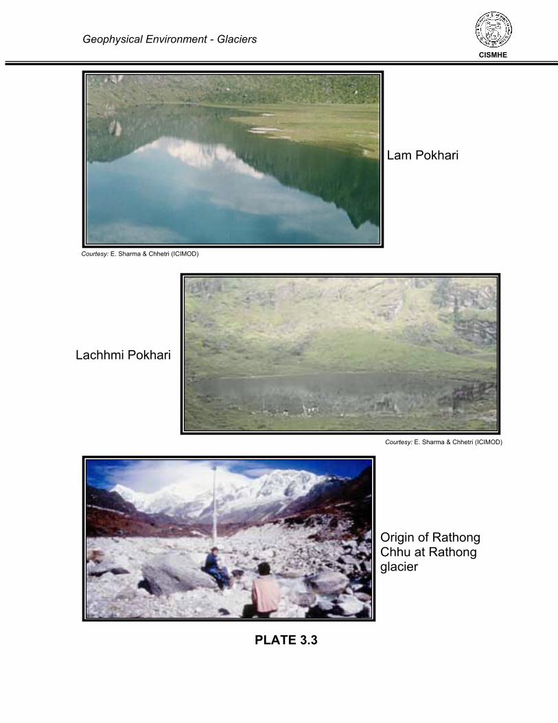
Geophysical Environment - Glaciers
CISMHE
PLATE 3.3
Lam Pokhari
Lachhmi Pokhari
Origin of Rathong Chhu at Rathong glacier
Courtesy: E. Sharma & Chhetri (ICIMOD)
Courtesy: E. Sharma & Chhetri (ICIMOD)

Geophysical Environment - Glaciers
CISMHE
PLATE – 3.4
Dalle Pokhari
Jore Pokhari
Khecheopalri Lake
Courtesy: E. Sharma & Chhetri (ICIMOD)
Courtesy: E. Sharma & Chhetri (ICIMOD)


Annexure-1 Glacial Lakes of Teesta basin in Sikkim
ID Lakes Name Area (sq m) Elevation District Watershed Longitude, Latitude1 No Name 36075.196 5190 m North Chhombo_Chhu 88:44:46 27:59:47 2 Naku_Chok_Tso 10,355.82 3970 m East Dik_Chhu 88:46:57 27:24:30 3 No Name 12,781.36 4300 m North Lachen_Chhu 88:31:33 27:40:47 4 Tosa Chho 205,618.39 4120 m North Lachung_Chhu 88:45:13 27:27:58 5 No Name 7,387.49 4240 m North_West Prek_Chhu 88:07:06 27:25:16 6 No Name 10,672.69 4100 m East Rangpo Chhu 88:46:46 27:23:47 7 Kishong Chho 189,417.31 4120 m North Rangyong_Chhu 88:27:19 27:43:19 8 Chhejo Pokhari 140,803.70 1820 m West Rathong_Chhu 88:11:25 27:21:00 9 no name 55,256.74 4610 m west Reli Chhu 88.14.00 27.29.41 10 No Name 14,294.88 4780 m North Yumthang_Chhu 88:50:28 27:41:26 11 No Name 8,691.93 4640 m North Zemu_Chhu 88:26:35 27:44:34 12 Gayum Chhona 259924.247 4993 m North Chhombo_Chhu 88:37:57 28:03:27 13 No Name 11,469.45 4360 m East Dik_Chhu 88:47:48 27:24:41 14 No Name 11,472.47 4540 m North Lachen_Chhu 88:30:55 27:42:14 15 No Name 32,709.24 4480 m North Lachung_Chhu 88:45:42 27:36:40 16 Chamliya Pokhari 116,733.80 4560 m North_West Prek_Chhu 88:11:28 27:34:52 17 No Name 10,798.08 4060 m East Rangpo Chhu 88:47:29 27:23:47 18 Laha Jheel 32,943.87 4320 m North Rangyong_Chhu 88:30:11 27:40:44 19 Lachhmi Pokhari 2 20,478.86 4380 m West Rathong_Chhu 88:04:43 27:25:37 20 no name 16,083 4660 m west Reli Chhu 21 No Name 10,444.20 4720 m North Yumthang_Chhu 88:49:55 27:43:03 22 Mukti Boul Jheel 33,508.84 4860 m North Zemu_Chhu 88:23:29 27:44:42 23 No Name 63214.88 5305 m North Chhombo_Chhu 88:48:13 27:59:65 24 Chho_Pinsum2 99,815.14 3980 m East Dik_Chhu 88:46:24 27:24:06 25 No Name 45,993.05 4100 m North Lachen_Chhu 88:32:03 27:41:07 26 No Name 25,495.00 4500 m North Lachung_Chhu 88:48:09 27:38:53 27 No Name 8,620.82 4520 m North_West Prek_Chhu 88:11:31 27:34:32 28 No Name 6,861.49 4000 m East Rangpo Chhu 88:46:47 27:23:32 29 No Name 8,569.22 4510 m North Rangyong_Chhu 88:30:37 27:40:39 30 Lachhmi Pokhari 1 12,229.04 4420 m West Rathong_Chhu 88:05:04 27:25:44 31 No Name 3,233.72 5280 m North Yumthang_Chhu 88:50:58 27:44:21 32 No Name 39,104.15 4540 m North Zemu_Chhu 88:26:06 27:44:42 33 No Name 51942.963 5305 m North Chhombo_Chhu 88:48:10 27:59:46 34 Chho_Pinsum1 24,087.12 3970 m East Dik_Chhu 88:46:12 27:24:15 35 No Name 76,399.66 4520 m North Lachen_Chhu 88:30:57 27:41:55 36 No Name 60,787.54 4620 m North Lachung_Chhu 88:50:09 27:40:20 37 No Name 10,504.06 4580 m North_West Prek_Chhu 88:11:01 27:34:32 38 No Name 29,433.15 4200 m East Rangpo Chhu 88:49:04 27:23:24 39 No Name 33,685.56 4280 m North Rangyong_Chhu 88:29:50 27:40:29 40 No Name 4,363.33 4350 m West Rathong_Chhu 88:04:47 27:25:27

41 No Name 25,181.81 4760 m North Yumthang_Chhu 88:50:12 27:44:32 42 No Name 2,292.40 4500 m North Zemu_Chhu 88:26:14 27:44:55 43 No Name 42880.495 5170 m North Chhombo_Chhu 88:45:00 27:59:55 44 Naku_Chho2 6,912.60 4160 m East Dik_Chhu 88:45:34 27:26:38 45 No Name 14,277.80 4480 m North Lachung_Chhu 88:48:55 27:14:03 46 No Name 14,163.70 4440 m North_West Prek_Chhu 88:10:65 27:33:59 47 Syebiruka Chho 128,366.55 4060 m East Rangpo Chhu 88:48:14 27:23:14 48 No Name 9,124.26 4470 m North Rangyong_Chhu 88:30:18 27:40:58 49 Lam Pokhari 26,837.45 4340 m West Rathong_Chhu 88:05:02 27:25:26 50 No Name 9,382.67 4720 m North Yumthang_Chhu 88:49:28 27:44:50 51 Lamgepui Chho 96,901.71 4560 m North Zemu_Chhu 88:29:12 27:45:34 52 No Name 20559.938 5140 m North Chhombo_Chhu 88:45:08 27:59:57 53 Naku Chho 108,423.01 4080 m East Dik_Chhu 88:45:19 27:26:32 54 No Name 59,617.04 4480 m North Lachung_Chhu 88:48:43 27:40:58 55 Sungmoteng Chho 23,095.44 4300 m North_West Prek_Chhu 88:11:23 27:33:41 56 Sherathang Chho 27,856.51 3880 m East Rangpo Chhu 88:48:47 27:23:02 57 No Name 44,769.86 4040 m North Rangyong_Chhu 88:29:46 27:39:55 58 Gounian Pokhari 5,340.34 4180 m West Rathong_Chhu 88:05:21 27:24:42 59 No Name 135,256.92 4740 m North Yumthang_Chhu 88:48:11 27:47:47 60 Thomphyan Tso 28,361.99 4700 m North Zemu_Chhu 88:24:54 27:47:10 61 Gurudongmar Lake2 689861.371 5300 m North Chhombo_Chhu 88:42:01 28:00:28 62 Pemthang_Chho3 39,894.45 4080 m East Dik_Chhu 88:45:36 27:25:34 63 No Name 5,800.86 3990 m North Lachung_Chhu 88:40:04 27:39:36 64 Nor Pokhari 29,770.96 4240 m North_West Prek_Chhu 88:12:05 27:30:28 65 No Name 60,304.66 4120 m East Rangpo Chhu 88:50:01 27:22:49 66 No Name 60,421.31 4040 m North Rangyong_Chhu 88:29:59 27:40:09 67 Sukhia Pokhari 5,643.50 4200 m West Rathong_Chhu 88:04:15 27:25:17 68 No Name 29,954.94 4340 m North Yumthang_Chhu 88:42:38 27:45:08 69 No Name 9,947.10 4720 m North Zemu_Chhu 88:26:44 27:48:27 70 Gyapji_Chho2 111982.838 4740 m North Chhombo_Chhu 88:35:44 27:58:11 71 Pemthang_Chho4 18,634.23 4080 m East Dik_Chhu 88:45:26 27:25:27 72 No Name 8,958.57 3940 m North Lachung_Chhu 88:40:08 27:39:43 73 Tinkone Pokhari 20,818.20 3980 m North_West Prek_Chhu 88:12:02 27:29:24 74 No Name 44,197.25 4060 m East Rangpo Chhu 88:49:45 27:22:50 75 Shingo Chho 287,670.86 4520 m North Rangyong_Chhu 88:30:54 27:40:18 76 No Name 155,170.95 4620 m North Yumthang_Chhu 88:39:32 27:48:55 77 No Name 12,081.57 4580 m North Zemu_Chhu 88:26:10 27:48:34 78 No Name 48209.49 4760 m North Chhombo_Chhu 88:36:23 27:55:29 79 Pemthang_Chho2 7,505.64 4080 m East Dik_Chhu 88:45:44 27:25:35 80 No Name 12,073.17 4220 m North Lachung_Chhu 88:40:40 27:39:43 81 Jokte Pokhari 10,255.46 4200 m North_West Prek_Chhu 88:09:54 27:29:58 82 Namnang Chho(Chho Sum)1 33,679.00 4400 m East Rangpo Chhu 88:51:18 27:22:48 83 No Name 14,389.88 4640 m North Rangyong_Chhu 88:26:06 27:43:53 84 No Name 160,539.10 5000 m North Yumthang_Chhu 88:48:26 27:50:29

85 No Name 4,454.33 4680 m North Zemu_Chhu 88:25:21 27:48:45 86 No Name 9812.87 4500 m North Chhombo_Chhu 88:38:23 27:47:00 87 No Name 7,269.52 4140 m East Dik_Chhu 88:47:10 27:25:05 88 No Nae 76,094.55 4200 m North Lachung_Chhu 88:41:14 27:40:07 89 Khangla Khang Tso 43,134.75 4680 m North_West Prek_Chhu 88:05:07 27:30:36 90 Namnang Chho(Chho Sum)2 38,992.03 4120 m East Rangpo Chhu 88:51:06 27:22:34 91 No Name 10,867.79 4400 m North Rangyong_Chhu 88:27:33 27:43:45 92 No Name 12,198.42 5030 m North Yumthang_Chhu 88:48:21 27:51:05 93 No Name 4,826.11 4500 m North Zemu_Chhu 88:28:10 27:48:51 94 No Name 3418.963 5060 m North Chhombo_Chhu 88:38:13 27:52:11 95 No Name 11,329.47 4200 m East Dik_Chhu 88:47:38 27:25:13 96 Chhunzomui Chhokha 237,301.37 4320 m North Lachung_Chhu 88:43:11 27:41:51 97 No Name 11,120.93 4750 m North_West Prek_Chhu 88:05:47 27:29:44 98 Tsomgo Chho 234,146.53 3740 m East Rangpo Chhu 88:46:00 27:22:28 99 No Name 10,098.24 3280 m North Rangyong_Chhu 88:25:59 27:42:03
100 Chhopup Chho 39,888.89 4760 m North Yumthang_Chhu 88:51:00 27:49:48 101 No Name 3,623.32 4670 m North Zemu_Chhu 88:27:48 27:48:54 102 No Name 4072.643 4920 m North Chhombo_Chhu 88:38:08 27:51:58 103 Ratechhungu_Chho 8,459.59 4420 m East Dik_Chhu 88:48:07 27:25:09 104 No Name 16,621.70 3840 m North Lachung_Chhu 88:40:58 27:42:31 105 No Name 27,169.72 4720 m North_West Prek_Chhu 88:04:14 27:29:59 106 Namnang Chho 69,856.42 4040 m East Rangpo Chhu 88:50:55 27:22:17 107 Chhopup Chho 2 57,783.65 4800 m North Yumthang_Chhu 88:51:13 27:49:33 108 No Name 17,472.80 4840 m North Zemu_Chhu 88:25:23 27:48:58 109 No Name 21239.671 5040 m North Chhombo_Chhu 88:37:48 27:52:20 110 Tamze_Chho(Hans_Pokhri) 66,968.75 3931 m East Dik_Chhu 88:46:23 27:25:58 111 Jockchen2 11,485.89 4060 m North Lachung_Chhu 88:40:44 27:43:08 112 No Name 4,398.91 4680 m North_West Prek_Chhu 88:04:26 27:30:02 113 No Name 7,215.13 4040 m East Rangpo Chhu 88:49:09 27:22:13 114 No Name 36,883.70 4920 m North Yumthang_Chhu 88:52:08 27:50:09 115 No Name 10,342.36 4500 m North Zemu_Chhu 88:28:02 27:49:02 116 No Name 22136.271 5040 m North Chhombo_Chhu 88:38:08 27:52:16 117 No Name 48,235.57 4480 m East Dik_Chhu 88:47:35 27:25:58 118 Jockchen 32,621.47 4280 m North Lachung_Chhu 88:40:40 27:43:20 119 No Name 2,312.69 4770 m North_West Prek_Chhu 88:04:19 27:30:01 120 No Name 250,690.11 3925 m East Rangpo Chhu 88:49:38 27:22:05 121 No Name 50,130.00 5320 m North Yumthang_Chhu 88:52:48 27:50:30 122 No Name 6,196.93 4620 m North Zemu_Chhu 88:27:48 27:49:01 123 No Name 21060.562 4920 m North Chhombo_Chhu 88:37:22 27:55:02 124 Chhu_Lu 13,036.79 4240 m East Dik_Chhu 88:47:11 27:26:17 125 No Name 40,335.06 3920 m North Lachung_Chhu 88:41:09 27:43:43 126 Khangla Chho 53,540.93 4860 m North_West Prek_Chhu 88:03:25 27:30:01 127 No Name 22,705.56 4040 m East Rangpo Chhu 88:49:12 27:22:07 128 Kasang Chho 56,953.72 4940 m North Yumthang_Chhu 88:52:14 27:50:51

129 No Name 10,172.86 4830 m North Zemu_Chhu 88:24:51 27:49:03 130 Burum Chokha 16426.159 4410 m North Chhombo_Chhu 88:36:14 27:47:34 131 Pemthang_Chho5 48,089.52 4080 m East Dik_Chhu 88:45:22 27:25:42 132 No Name 10,698.83 4620 m North Lachung_Chhu 88:46:40 27:44:14 133 No Name 6,624.68 4580 m North_West Prek_Chhu 88:03:07 27:29:44 134 No Name 8,732.63 4100 m East Rangpo Chhu 88:49:01 27:22:04 135 No Name 47,244.60 4980 m North Yumthang_Chhu 88:52:41 27:51:02 136 No Name 29,010.61 4740 m North Zemu_Chhu 88:26:15 27:49:05 137 No Name 6299.606 4440 m North Chhombo_Chhu 88:34:30 27:51:13 138 Pemthang_Chho1 74,087.43 4080 m East Dik_Chhu 88:45:41 27:25:46 139 No Name 8,300.03 4600 m North Lachung_Chhu 88:41:42 27:44:09 140 Khangla Chho 21,146.59 4450 m North_West Prek_Chhu 88:03:11 27:29:24 141 No Name 9,437.35 4040 m East Rangpo Chhu 88:48:48 27:22:04 142 No Name 19,068.21 4940 m North Yumthang_Chhu 88:52:28 27:51:04 143 No Name 30,040.50 4880 m North Zemu_Chhu 88:25:02 27:49:11 144 No Name 11912.156 4300 m North Chhombo_Chhu 88:34:39 27:51:27 145 No Name 18,116.42 4160 m East Dik_Chhu 88:46:04 27:26:26 146 No Name 10,045.90 4840 m North Lachung_Chhu 88:41:59 27:44:34 147 No Name 21,589.66 4540 m North_West Prek_Chhu 88:03:03 27:28:15 148 No Name 8,552.26 4040 m East Rangpo Chhu 88:49:20 27:22:03 149 No Name 15,336.71 4840 m North Yumthang_Chhu 88:52:02 27:51:36 150 No Name 6,462.73 4940 m North Zemu_Chhu 88:24:40 27:49:22 151 No Name 9222.369 4440 m North Chhombo_Chhu 88:35:08 27:52:56 152 No Name 19,003.63 4700 m North Lachung_Chhu 88:40:56 27:44:44 153 Mujur Pokhari 93,703.57 4250 m North_West Prek_Chhu 88:03:25 27:28:42 154 No Name 11,770.82 4080 m East Rangpo Chhu 88:48:55 27:21:58 155 No Name 130,357.90 4880 m North Yumthang_Chhu 88:51:54 27:15:50 156 No Name 56,733.76 5040 m North Zemu_Chhu 88:25:21 27:49:28 157 Shera_Phu 114983.029 4840 m North Chhombo_Chhu 88:37:09 27:55:19 158 No Name 18,291.75 4000 m North Lachung_Chhu 88:36:52 27:44:40 159 Khangla Chho 19,035.64 4450 m North_West Prek_Chhu 16:03:42 27:28:54 160 Elep Chho 1 44,603.19 4600 m East Rangpo Chhu 88:52:22 27:21:31 161 No Name 52,230.14 5080 m North Yumthang_Chhu 88:51:29 27:52:23 162 No Name 137,049.79 5280 m North Zemu_Chhu 88:19:15 27:49:49 163 No Name 34863.392 4720 m North Chhombo_Chhu 88:30:34 27:50:37 164 No Name 27,566.97 4000 m North Lachung_Chhu 88:37:39 27:45:33 165 No Name 6,070.81 4520 m North_West Prek_Chhu 88:04:26 27:28:36 166 Elep Chho 2 57,151.71 4600 m East Rangpo Chhu 88:52:37 27:21:25 167 No Name 9,435.93 4520 m North Yumthang_Chhu 88:49:59 27:51:10 168 Langpo Chho 109,946.27 5320 m North Zemu_Chhu 88:14:04 27:50:33 169 No Name 27957.702 4880 m North Chhombo_Chhu 88:30:38 27:51:00 170 No Name 9,625.98 4420 m North Lachung_Chhu 88:38:56 27:46:02 171 No Name 16,608.53 4045 m North_West Prek_Chhu 88:05:59 27:28:17 172 Elep Chho 3 35,752.32 4640 m East Rangpo Chhu 88:52:46 27:21:17

173 No Name 16,809.63 4600 m North Yumthang_Chhu 88:49:27 27:51:26 174 Goma Sechen Tso1 159,793.19 5240 m North Zemu_Chhu 88:15:13 27:52:50 175 No Name 44487.386 4540 m North Chhombo_Chhu 88:34:45 27:54:09 176 No Name 8,730.42 4420 m North Lachung_Chhu 88:38:53 27:46:00 177 No Name 6,433.11 4210 m North_West Prek_Chhu 88:13:28 27:28:50 178 Menmoi Chho 221,221.95 3660 m East Rangpo Chhu 88:49:34 27:20:56 179 No Name 108,532.22 4940 m North Yumthang_Chhu 88:47:30 27:52:23 180 Goma Sechen Tso2 84,323.63 5180 m North Zemu_Chhu 88:15:46 27:52:56 181 No Name 2497.533 4490 m North Chhombo_Chhu 88:34:07 27:54:09 182 No Name 37,477.81 4420 m North Lachung_Chhu 88:38:50 27:46:22 183 Dalle Pokhari 17,333.51 4280 m North_West Prek_Chhu 88:13:10 27:29:03 184 Chhokhya Chho 40,072.72 3960 m East Rangpo Chhu 88:50:36 27:18:30 185 Khang Kyong 502,396.46 5320 m North Yumthang_Chhu 88:45:51 27:53:40 186 Goma Sechen Tso3 108,450.65 5160 m North Zemu_Chhu 88:16:05 27:53:07 187 No Name 39158.367 4880 m North Chhombo_Chhu 88:30:25 27:51:00 188 No Name 4,915.67 4170 m North_West Prek_Chhu 88:13:43 27:28:35 189 No Name 23,510.13 3860 m East Rangpo Chhu 88:50:20 27:18:16 190 No Name 7,669.12 5300 m North Yumthang_Chhu 88:39:45 27:55:06 191 Goma Sechen Tso4 96,229.09 5140 m North Zemu_Chhu 88:15:49 27:53:32 192 No Name 7728.059 4720 m North Chhombo_Chhu 88:30:13 27:54:55 193 No Name 2,384.35 4465 m North_West Prek_Chhu 88:14:08 27:28:38 194 No Name 29,730.61 1640 m East Rangpo Chhu 88:40:45 27:11:11 195 Sebu Chho 1 72,518.41 4820 m North Yumthang_Chhu 88:40:59 27:55:21 196 No Nmae 22,556.16 5220 m North Zemu_Chhu 88:19:48 27:53:39 197 No Name 8338.876 4790 m North Chhombo_Chhu 88:30:08 27:55:06 198 No Name 3,436.82 4480 m North_West Prek_Chhu 88:14:13 27:28:43 199 Sebu Chho 2 147,218.75 4840 m North Yumthang_Chhu 88:40:25 27:55:08 200 No Nmae 29,641.64 5220 m North Zemu_Chhu 88:19:44 27:53:49 201 No Name 3100.503 4860 m North Chhombo_Chhu 88:30:24 27:55:01 202 No Name 3,004.03 4270 m North_West Prek_Chhu 88:14:06 27:28:17 203 No Name 28,088.40 5100 m North Yumthang_Chhu 88:40:10 27:55:41 204 S. Lhonak Chho 707,403.63 5300 m North Zemu_Chhu 88:12:14 27:54:45 205 Khangchung_Chho 1642411.686 5310 m North Chhombo_Chhu 88:49:02 27:59:28 206 No Name 2,152.37 4320 m North_West Prek_Chhu 88:14:08 27:28:14 207 No Name 10,647.71 5120 m North Yumthang_Chhu 88:40:07 27:55:52 208 N. Lhonak Chho 105,253.50 5540 m North Zemu_Chhu 88:10:22 27:55:08 209 No Name 17548.426 5230 m North Chhombo_Chhu 88:44:26 27:59:24 210 No Name 2,219.59 3900 m North_West Prek_Chhu 88:06:19 27:27:32 211 No Name 43,971.35 5170 m North Yumthang_Chhu 88:39:43 27:56:00 212 No Name 138,291.41 5180 m North Zemu_Chhu 88:19:00 27:55:12 213 Mashya_Tso 77974.139 5240 m North Chhombo_Chhu 88:45:57 27:59:37 214 No Name 10,722.73 4340 m North_West Prek_Chhu 88:04:25 27:27:00 215 No Name 5,941.20 4930 m North Yumthang_Chhu 88:41:11 27:56:06 216 No Name 19,743.31 5540 m North Zemu_Chhu 88:10:25 27:55:17

217 No Name 5139.293 4990 m North Chhombo_Chhu 88:39:09 27:57:43 218 No Name 13,542.96 4410 m North_West Prek_Chhu 88:04:35 27:26:51 219 No Name 5,458.51 4930 m North Yumthang_Chhu 88:41:12 27:56:00 220 No Name 91,317.53 5240 m North Zemu_Chhu 88:16:10 27:56:10 221 No Name 6987.067 4785 m North Chhombo_Chhu 88:39:06 27:57:49 222 Lachhimi Pokhari 161,008.10 4300 m North_West Prek_Chhu 88:05:08 27:26:14 223 No Name 3,285.06 5030 m North Yumthang_Chhu 88:41:14 27:56:42 224 Khora Chho 550,688.25 5160 m North Zemu_Chhu 88:20:03 27:56:47 225 No Name 4772.922 4790 m North Chhombo_Chhu 88:38:52 27:57:46 226 Thullo Lumle Pokhari 2 18,327.77 4440 m North_West Prek_Chhu 88:05:24 27:25:15 227 No Name 9,516.10 5020 m North Yumthang_Chhu 88:41:20 27:56:43 228 No Name 70,113.05 5240 m North Zemu_Chhu 88:16:29 27:56:33 229 Gurudongmar Lake1 1087435.095 5165 m North Chhombo_Chhu 88:42:47 28:01:29 230 Thullo Lumle Pokhari 1 7,651.30 4410 m North_West Prek_Chhu 88:05:13 27:25:56 231 No Name 4,407.33 5040 m North Yumthang_Chhu 88:41:16 27:56:51 232 No Name 332,720.35 5180 m North Zemu_Chhu 88:18:30 27:56:57 233 No Name 18482.737 5020 m North Chhombo_Chhu 88:38:07 27:57:49 234 Sano Jumle Pokhari 2 1,716.98 4340 m North_West Prek_Chhu 88:07:00 27:25:31 235 No Name 7,329.58 5050 m North Yumthang_Chhu 88:41:29 27:56:52 236 No Name 24,786.10 5180 m North Zemu_Chhu 88:19:28 27:56:45 237 Simala_Jheel2 46473.283 5640 m North Chhombo_Chhu 88:39:25 28:00:15 238 Sano Jumle Pokhari 1 3,409.02 4360 m North_West Prek_Chhu 88:07:02 27:25:34 239 No Name 6,306.75 5070 m North Yumthang_Chhu 88:41:27 27:57:00 240 Tso Chik 46,386.71 5460 m North Zemu_Chhu 88:13:17 27:56:47 241 Cheora_Tso 47952.534 4990 m North Chhombo_Chhu 88:41:18 28:02:41 242 Sukhe Pokhari 6,310.63 4060 m North_West Prek_Chhu 88:11:38 27:29:46 243 No Name 2,666.26 5110 m North Yumthang_Chhu 88:14:17 27:57:20 244 Chhora Chhobuk 111,494.21 5020 m North Zemu_Chhu 88:21:22 27:57:00 245 Chho_Lhamo1 1042844.868 5060 m North Chhombo_Chhu 88:45:31 28:00:39 246 Lam Pokhari 100,878.52 4280 m North_West Prek_Chhu 88:12:56 27:29:16 247 No Name 10,062.87 5250 m North Yumthang_Chhu 88:42:58 27:56:36 248 No Name 42,651.19 5220 m North Zemu_Chhu 88:17:55 27:57:08 249 Simala_Jheel1 132315.454 5540 m North Chhombo_Chhu 88:39:15 28:00:44 250 No Name 13,936.60 5320 m North Yumthang_Chhu 88:43:19 27:56:32 251 No Name 61,769.31 5160 m North Zemu_Chhu 88:24:05 27:57:15 252 Gurudongmar Lake3 1075692.87 5360 m North Chhombo_Chhu 88:42:55 28:00:21 253 No Name 16,636.96 5320 m North Yumthang_Chhu 88:43:21 27:56:52 254 Tso Chhobek 170,911.79 5020 m North Zemu_Chhu 88:21:39 27:57:19 255 Taga_Chho 13246.866 4815 m North Chhombo_Chhu 88:35:35 27:57:44 256 No Name 32,581.91 4920 m North Yumthang_Chhu 88:42:24 27:57:02 257 Bhut Pokhari 75,342.52 5180 m North Zemu_Chhu 88:23:27 27:57:26 258 Gongng_Tso 20535.932 4740 m North Chhombo_Chhu 88:34:09 27:57:32 259 No Name 6,546.95 5360 m North Yumthang_Chhu 88:43:52 27:56:21 260 No Name 13,211.40 5260 m North Zemu_Chhu 88:20:17 27:57:35
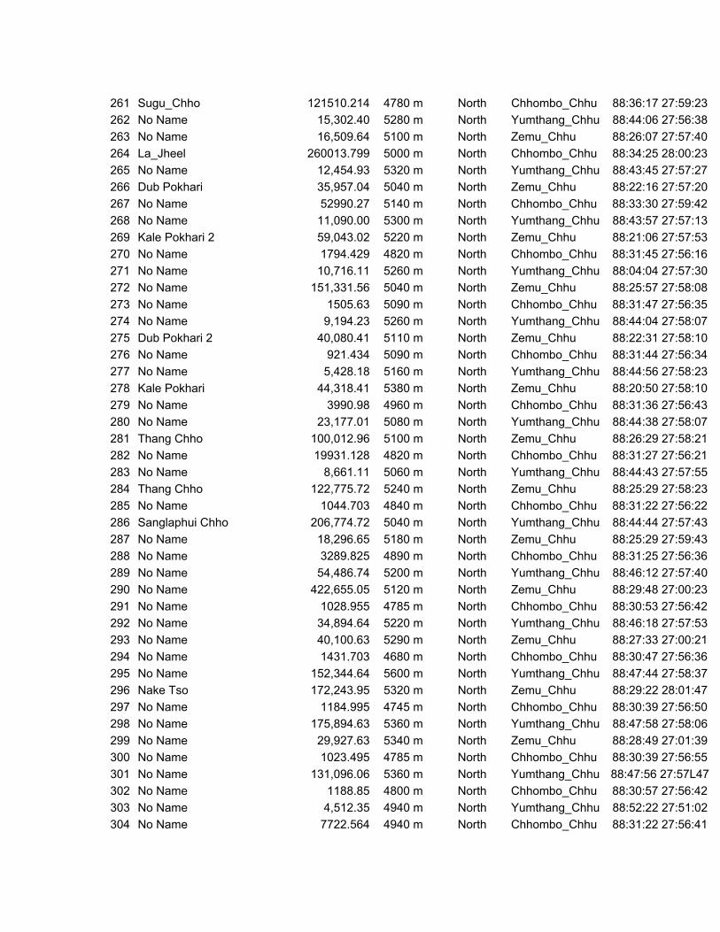
261 Sugu_Chho 121510.214 4780 m North Chhombo_Chhu 88:36:17 27:59:23 262 No Name 15,302.40 5280 m North Yumthang_Chhu 88:44:06 27:56:38 263 No Name 16,509.64 5100 m North Zemu_Chhu 88:26:07 27:57:40 264 La_Jheel 260013.799 5000 m North Chhombo_Chhu 88:34:25 28:00:23 265 No Name 12,454.93 5320 m North Yumthang_Chhu 88:43:45 27:57:27 266 Dub Pokhari 35,957.04 5040 m North Zemu_Chhu 88:22:16 27:57:20 267 No Name 52990.27 5140 m North Chhombo_Chhu 88:33:30 27:59:42 268 No Name 11,090.00 5300 m North Yumthang_Chhu 88:43:57 27:57:13 269 Kale Pokhari 2 59,043.02 5220 m North Zemu_Chhu 88:21:06 27:57:53 270 No Name 1794.429 4820 m North Chhombo_Chhu 88:31:45 27:56:16 271 No Name 10,716.11 5260 m North Yumthang_Chhu 88:04:04 27:57:30 272 No Name 151,331.56 5040 m North Zemu_Chhu 88:25:57 27:58:08 273 No Name 1505.63 5090 m North Chhombo_Chhu 88:31:47 27:56:35 274 No Name 9,194.23 5260 m North Yumthang_Chhu 88:44:04 27:58:07 275 Dub Pokhari 2 40,080.41 5110 m North Zemu_Chhu 88:22:31 27:58:10 276 No Name 921.434 5090 m North Chhombo_Chhu 88:31:44 27:56:34 277 No Name 5,428.18 5160 m North Yumthang_Chhu 88:44:56 27:58:23 278 Kale Pokhari 44,318.41 5380 m North Zemu_Chhu 88:20:50 27:58:10 279 No Name 3990.98 4960 m North Chhombo_Chhu 88:31:36 27:56:43 280 No Name 23,177.01 5080 m North Yumthang_Chhu 88:44:38 27:58:07 281 Thang Chho 100,012.96 5100 m North Zemu_Chhu 88:26:29 27:58:21 282 No Name 19931.128 4820 m North Chhombo_Chhu 88:31:27 27:56:21 283 No Name 8,661.11 5060 m North Yumthang_Chhu 88:44:43 27:57:55 284 Thang Chho 122,775.72 5240 m North Zemu_Chhu 88:25:29 27:58:23 285 No Name 1044.703 4840 m North Chhombo_Chhu 88:31:22 27:56:22 286 Sanglaphui Chho 206,774.72 5040 m North Yumthang_Chhu 88:44:44 27:57:43 287 No Name 18,296.65 5180 m North Zemu_Chhu 88:25:29 27:59:43 288 No Name 3289.825 4890 m North Chhombo_Chhu 88:31:25 27:56:36 289 No Name 54,486.74 5200 m North Yumthang_Chhu 88:46:12 27:57:40 290 No Name 422,655.05 5120 m North Zemu_Chhu 88:29:48 27:00:23 291 No Name 1028.955 4785 m North Chhombo_Chhu 88:30:53 27:56:42 292 No Name 34,894.64 5220 m North Yumthang_Chhu 88:46:18 27:57:53 293 No Name 40,100.63 5290 m North Zemu_Chhu 88:27:33 27:00:21 294 No Name 1431.703 4680 m North Chhombo_Chhu 88:30:47 27:56:36 295 No Name 152,344.64 5600 m North Yumthang_Chhu 88:47:44 27:58:37 296 Nake Tso 172,243.95 5320 m North Zemu_Chhu 88:29:22 28:01:47 297 No Name 1184.995 4745 m North Chhombo_Chhu 88:30:39 27:56:50 298 No Name 175,894.63 5360 m North Yumthang_Chhu 88:47:58 27:58:06 299 No Name 29,927.63 5340 m North Zemu_Chhu 88:28:49 27:01:39 300 No Name 1023.495 4785 m North Chhombo_Chhu 88:30:39 27:56:55 301 No Name 131,096.06 5360 m North Yumthang_Chhu 88:47:56 27:57L47 302 No Name 1188.85 4800 m North Chhombo_Chhu 88:30:57 27:56:42 303 No Name 4,512.35 4940 m North Yumthang_Chhu 88:52:22 27:51:02 304 No Name 7722.564 4940 m North Chhombo_Chhu 88:31:22 27:56:41

305 Sima Chhokha 139,410.57 4440 m North Yumthang_Chhu 88:50:05 27:43:48 306 No Name 7199.298 4740 m North Chhombo_Chhu 88:30:42 27:56:46 307 No Name 6,626.96 5020 m North Yumthang_Chhu 88:41:19 27:56:27 308 No Name 2237.502 4635 m North Chhombo_Chhu 88:30:22 27:57:33 309 No Name 3265.912 4650 m North Chhombo_Chhu 88:30:22 27:57:39 310 No Name 3564.794 4675 m North Chhombo_Chhu 88:30:22 27:57:45 311 Bhut Pokhari 160078.422 4920 m North Chhombo_Chhu 88:30:34 27:58:47 312 Chho Yummo 35528.537 5220 m North Chhombo_Chhu 88:34:33 28:02:15 313 Lha Tso 254055.398 5140 m North Chhombo_Chhu 88:33:49 28:00:48 314 Gyapji Chho1 551589.188 5000 m North Chhombo_Chhu 88:37:03 27:58:23 315 Mukti Boul Jheel 36063.226 5040 m North Chhombo_Chhu 88:36:37 28:01:27 316 Lungma Chho 56808.636 5440 m North Chhombo_Chhu 88:34:42 28:03:18


i
CISMHE
C O N T E N T S
VOLUME-I INTRODUCTORY VOLUME
CHAPTER 1 INTRODUCTION 1.1 STUDY AREA 1.2 PHYSICAL FEATURES 1.3 GEOLOGICAL SETTING 1.4 RIVER TEESTA 1.5 HYDRO-METEOROLOGY 1.6 DEVELOPMENT SCENARIO CHAPTER 2 CONCEPT AND METHODOLOGY 2.1 CARRYING CAPACITY 2.2 DEVELOPMENTAL PLANNING AND CARRYING CAPACITY 2.3 EXISTING ENVIRONMENTAL RESOURCE BASE CHAPTER 3 PROPOSED POWER DEVELOPMENT PROFILE OF TEESTA BASIN 3.1 POWER DEVELOPMENT SCENARIO 3.2 POWER REQUIREMENT 3.3 HYDRO POWER POTENTIAL IN TEESTA BASIN CHAPTER 4 TEESTA RIVER SYSTEM – THE STUDY AREA 4.1 INTRODUCTION 4.2 CHHOMBO CHHU/TEESTA RIVER UPSTREAM OF ZEMU CHHU-TEESTA CONFLUENCE 4.3 LACHUNG CHHU 4.4 ZEMU CHHU 4.5 TEESTA RIVER BETWEEN LACHEN AND CHUNGTHANG 4.6 CHUNGTHANG-MANGAN-CHAKUNG CHHU SUB-SYSTEM 4.7 TALUNG CHHU (RANGYONG CHHU) 4.8 RANGIT RIVER SUB-SYSTEM 4.9 DIK CHHU SUB-SYSTEM 4.10 RANGPO CHHU 4.11 TEESTA RIVER BETWEEN MANGAN AND SINGTAM 4.12 RANI KHOLA (RONGNI CHHU)

ii
CISMHE
4.13 TEESTA RIVER BETWEEN TEESTA-RANI KHOLA CONFLUENCE AND TEESTA-RANGPO CHHU CONFLUENCE
4.14 TEESTA RIVER PROFILE 4.15 IMPLICATIONS CHAPTER 5 NODAL POINTS OF WATER RESOURCE IN TEESTA BASIN 5.1 GEOMORPHIC PROFILE 5.2 NODAL POINTS OF WATER RESOURCE CHAPTER 6 TEESTA RIVER BASIN CHARACTERISTICS 6.1 INTRODUCTION 6.2 GEOMORPHOLOGICAL PROFILE OF TEESTA BASIN 6.3 RELIEF AND ASPECT 6.4 SLOPE 6.5 SOIL CHAPTER 7 REMOTE SENSING AND GIS STUDIES – LANDUSE/LANDCOVER MAPPING OF TEESTA BASIN 7.1 LANDUSE MAPPING 7.2 STUDY AREA 7.3 DATABASE 7.4 METHODOLOGY 7.5 CLASSIFICATION SCHEME 7.6 LANDUSE/ LANDCOVER 7.7 FOREST TYPE MAPPING BIBLIOGRAPHY ANNEXURE
VOLUME-II LAND ENVIRONMENT – GEOPHYSICAL ENVIRONMENT
CHAPTER 1 GEOLOGY AND SEISMICITY 1.1 GEOLOGICAL FRAMEWORK 1.2 STRATIGRAPHY 1.3 STRUCTURE, TECTONICS AND METAMORPHISM

iii
CISMHE
1.4 GEOMORPHOLOGY 1.5 MINERAL RESOURCES 1.6 SEISMICITY 1.7 GEOLOGICAL INVESTIGATIONS IN TEESTA BASIN IN SIKKIM 1.8 SPATIAL DISPOSITION OF STUDIED REGIONS ON THE SEISMOTECTONIC MAP OF SIKKIM 1.9 GEOLOGICAL SENSITIVITY AND VULNERABILITY CHAPTER 2 LANDSLIDES 2.1 INTRODUCTION 2.2 STATUS OF LANDSLIDES IN TEESTA BASIN 2.3 SOME EXISTING LANDSLIDES IN SIKKIM 2.4 CASE HISTORIES OF SOME IMPORTANT LANDSLIDES 2.5 ENVIRONMENTAL IMPACT OF THESE SLIDES 2.6 REMEDIAL MEASURES TO PREVENT LANDSLIDES 2.7 TYPICAL LANDSLIDE PROBLEM 2.8 FLOOD PROBLEM
2.9 SOCIO-ECONOMIC IMPLICATION OF FLOODS AND LAND EROSION/SLIDES
CHAPTER 3 GLACIERS 3.1 HIMALAYA AND GLACIERS 3.2 RECESSION OF GLACIERS 3.3 GLACIAL STUDIES IN SIKKIM 3.4 OBJECTIVE OF THE STUDY 3.5 GLACIERS 3.6 GLACIAL LAKES 3.7 DATA USED AND METHODOLOGY 3.8 INVENTORY OF GLACIERS 3.9 INVENTORY OF GLACIAL LAKES 3.10 GLACIERS OF SIKKIM HIMALAYA 3.11 MAJOR LAKES BIBLIOGRAPHY ANNEXURE

iv
CISMHE
VOLUME – III LAND ENVIRONMENT - SOIL
CHAPTER 1 INTRODUCTION CHAPTER 2 GEOGRAPHICAL SETTINGS 2.1 LOCATION AND EXTENT 2.2 GEOLOGY 2.3 GEOMORPHOLOGY 2.4 CLIMATE 2.5 DELINEATION OF WATERSHEDS CHAPTER 3 MORPHOMETRIC CHARACTERISTICS IN RANI KHOLA WATERSHED 3.1 ABSOLUTE RELIEF 3.2 RELATIVE RELIEF 3.3 DISSECTION INDEX 3.4 SLOPE CHAPTER 4 WATERSHEDS IN TEESTA BASIN 4.1 RANGPO CHHU WATERSHED 4.2 RANI KHOLA WATERSHED 4.3 TEESTA (LOWER PART) WATERSHED 4.4 DIK CHHU WATERSHED 4.5 TEESTA UPPER (LEFT BANK) WATERSHED 4.6 YUMTHANG CHHU WATERSHED 4.7 CHHOMBO CHHU WATERSHED 4.8 ZEMU CHHU WATERSHED 4.9 RANGYONG CHHU WATERSHED 4.10 TEESTA UPPER (RIGHT BANK) WATERSHED 4.11 PREK CHHU WATERSHED 4.12 REL CHHU WATERSHED 4.13 RATHONG CHHU WATERSHED 4.14 KALEJ KHOLA WATERSHED 4.15 RAMAM KHOLA WATERSHED 4.16 RANGIT RIVER WATERSHED

v
CISMHE
4.17 MANPUR KHOLA WATERSHED ANNEXURES
VOLUME – IV WATER ENVIRONMENT
CHAPTER 1 INTRODUCTION 1.1 OBJECTIVE OF THE STUDY 1.3 METHODOLOGY CHAPTER 2 SALIENT CHARACTERISTICS OF SIKKIM 2.1 LOCATION 2.2 PHYSIOGRAPHY 2.3 TOPOGRAPHY 2.4 THE TEESTA & ITS TRIBUTARIES 2.5 SOILS 2.6 DRAINAGE CHARACTERISTICS 2.7 DEVELOPMENT PROSPECTS CHAPTER 3 HYDRO-METEOROLOGY 3.1 GENERAL 3.2 CLIMATE 3.3 WATER REGIME 3.4 RAINGAUGE NETWORK 3.5 RAINFALL FEATURES 3.6 CLIMATOLOGICAL CHARACTERISTICS CHAPTER 4 HYDROLOGY 4.1 GENERAL 4.2 CATCHMENT AREA 4.3 ASSESSMENT OF SURFACE WATER RESOURCES 4.4 FLOOD HYDROLOGY 4.5 SEDIMENT LOAD
vi
CISMHE
CHAPTER 5 IRRIGATION 5.1 GENERAL 5.2 ULTIMATE AND CREATED IRRIGATION POTENTIAL 5.3 FINANCIAL PERFORMANCE OF I&CAD SECTOR 5.4 CENSUS OF MINOR IRRIGATION (1995-96) 5.5 MASTER PLAN FOR IRRIGATION DEVELOPMENT IN SIKKIM (1995) 5.6 PRESENT STATUS OF MINOR IRRIGATION SCHEMES 5.7 ORGANIZATIONAL STRUCTURE CHAPTER 6 LAND RESOURCE MANAGEMENT 6.1 GENERAL 6.2 LAND USE PATTERN 6.3 TEMPORAL TREND OF LAND USE IN THE STATE 6.4 DISTRICT WISE STATUS OF FALLOW LAND 6.5 LAND RESOURCE MANAGEMENT STRATEGY 6.6 PAST AND PRESENT EFFORTS ON LAND USE MANAGEMENT 6.7 SOIL CONSERVATION CHAPTER 7 AGRICULTURE 7.1 GENERAL 7.2 AREA UNDER CROPS, DRY AND WASTE LAND 7.3 LAND HOLDINGS 7.4 CROP CALENDER 7.5 CROPPING PATTERN 7.6 CROP WATER REQUIREMENT 7.7 NET IRRIGATION REQUIREMENT 7.8 GROSS IRRIGATION REQUIREMENT 7.9 AGRICULTURE PRODUCTION AND YIELD 7.10 STRATEGIES PROPOSED BY THE STATE FOR ADOPTION DURING TENTH FIVE YEAR PLAN 7.11 IMPROVED CULTIVATION PRACTICES 7.12 SUMMING UP CHAPTER 8 HORTICULTURE 8.1 GENERAL

vii
CISMHE
8.2 HORTICULTURE 8.3 FLORICULTURE 8.4 MEDICINAL AND AROMATIC PLANTS 8.5 BEEKEEPING 8.6 ORGANIC FARMING 8.7 ANIMAL HUSBANDRY 8.8 FISHERIES CHAPTER 9 DROUGHT- PRONE AREAS IN THE STATE 9.1 GENERAL 9.2 RAINFALL 9.3 REPORT OF THE SURVEY 9.4 PACKAGE OF SCHEMES FORMULATED BY DEPARTMENTAL COMMITTEE
CHAPTER 10 IRRIGATION AND WATER MANAGEMENT - PERSPECTIVE PLANNING
10.1 GENERAL 10.2 PRESENT STATUS OF IRRIGATION DEVELOPMENT 10.3 IDENTIFICATION OF MINOR IRRIGATION SCHEMES 10.4 DESIGN OF CANAL AND RELATED STRUCTURES 10.5 TYPICAL DESIGN OF MINOR IRRIGATION SCHEMES 10.6 OPERATION AND MAINTENANCE OF MINOR IRRIGATION SCHEMES 10.7 WATER RATES 10.9 PARTICIPATORY IRRIGATION MANAGEMENT IN THE STATE OF SIKKIM CHAPTER 11 CARRYING CAPACITY – PERSPECTIVE PLANNING 11.1 GENERAL 11.2 PERSPECTIVE PLANNING 11.3 PROJECTION OF NET SOWN AREA, GROSS CROPPED AREA AND IRRIGATED AREA 11.4 DOMESTIC WATER REQUIREMENT 11.5 IRRIGATION WATER REQUIREMENT 11.6 TOTAL WATER REQUIREMENT 11.7 AGRICULTURE PRODUCTION

viii
CISMHE
CHAPTER 12 FINDINGS AND STRATEGIC RECOMMENDATIONS 12.1 SALIENT CHARACTERISTICS 12.2 HYDROMETEOROLOGY 12.3 HYDROLOGY 12.4 IRRIGATION 12.5 LAND RESOURCE MANAGEMENT 12.6 AGRICULTURE 12.7 HORTICULTURE AND OTHER ALLIED AGRICULTURE
ACTIVITIES 12.8 DROUGHT PRONE AREAS 12.9 LAND SLIDES AND FLOOD MANAGEMENT 12.10 IRRIGATION AND WATER MANAGEMENT – PERSPECTIVE PLANNING 12.11 CARRYING CAPACITY – PERSPECTIVE PLANNING ANNEXURES
VOLUME – V AIR ENVIRONMENT
CHAPTER 1 CARRYING CAPACITY BASED DEVELOPMENT PLANNING PROCESS 1.1 INTRODUCTION 1.2 THE STUDY AREA – SIKKIM 1.3 OBJECTIVES 1.4 ASSIMILATIVE CAPACITY ASSESSMENT METHODOLOGY CHAPTER 2 APPROACH I- ESTIMATION OF ASSIMILATIVE CAPACITY
THROUGH VENTILATION COEFFICIENT 2.1 INTRODUCTION 2.2 METHODOLOGY AND DATA REQUIREMENT 2.3 RESULTS
ix
CISMHE
CHAPTER 3 APPROACH II- ASSESSMENT OF POLLUTION POTENTIAL USING AIR QUALITY MODELING
3.1 AIR QUALITY STUDIES USING MODELS 3.2 BASELINE ENVIRONMENTAL QUALITY OF AIR 3.3 MODEL DESCRIPTION 3.4 NORTH SIKKIM 3.5 SOUTH AND EAST REGIONS OF SIKKIM 3.6 GANGTOK 3.7 WEST SIKKIM CHAPTER 4 AIR QUALITY ASSESSMENT OF TEESTA RIVER BASIN IN SIKKIM
4.1 INTRODUCTION 4.2 METHODOLOGY 4.3 RESULTS 4.4 CONCLUSIONS
BIBLIOGRAPHY ANNEXURE
VOLUME – VI
BIOLOGICAL ENVIRONMENT
TERRESTRIAL AND AQUATIC RESOURCES
CHAPTER 1 FOREST TYPES & VEGETATION 1.1 TROPICAL MOIST DECIDUOUS FORESTS 1.2 SUB-TROPICAL FORESTS 1.3 MONTANE WET TEMPERATE FORESTS 1.4 SUB-ALPINE FOREST 1.5 ALPINE SCRUBS AND PASTURES 1.6 VEGETATION PROFILE CHAPTER 2 FLORISTICS 2.1 INTRODUCTION 2.2 PLANT EXPLORATIONS IN TEESTA BASIN

x
CISMHE
2.3 TAXONOMIC DIVERSTIY 2.4 PHYSIOGNOMIC DIVERSIT 2.5 PHYTOGEOGRAPHICAL AFFINITIES 2.6 ENDEMICS 2.7 THREATENED FLORA 2.8 RHODODENDRONS 2.9 PRIMULA SPP. 2.10 ORCHID DIVERSITY 2.11 ECONOMICALLY IMPORTANT PLANT SPECIES 2.12 FLORAL HOT SPOTS OF SIKKIM 2.13 PERSPECTIVE PLANNING CHAPTER 3 AQUATIC ENVIRONMENT AND WATER QUALITY 3.1 INTRODUCTION 3.2 METHODS 3.3 TEESTA RIVER 3.4 RANGPO CHHU 3.5 RANI KHOLA 3.6 RANGIT RIVER 3.7 RANGYONG CHHU 3.8 OTHER STREAMS OF TEESTA BASIN 3.9 CONCLUSION
3.10 LAKES 3.11 CONCLUSIONS CHAPTER 4 FISH FAUNA 4.1 INTRODUCTION 4.2 FISH COMPOSITION AND DISTRIBUTION 4.3 FISH MIGRATION IN SIKKIM 4.4 ENDEMIC AND THREATENED SPECIES 4.5 FISH INTRODUCTION IN SIKKIM 4.6 FISHERIES DEVELOPMENT IN SIKKIM 4.7 STRESSES ON FISH POPULATIONS IN SIKKIM 4.8 MITIGATION MEASURES CHAPTER 5 PROTECTED AREAS 5.1 INTRODUCTION
xi
CISMHE
5.2 KHANGCHENDZONGA BIOSPHERE RESERVE 5.3 KHANGCHENDZONGA NATIONAL PARK 5.4 MAENAM WILDLIFE SANCTUARY 5.5 SHINGBA RHODODENDRON SANCTUARY 5.6 KYONGNOSLA ALPINE SANCTUARY 5.7 BARSEY RHODODENDRON SANCTUARY 5.8 FAMBONG LHO WILDLIFE SANCTUARY 5.9 PANGOLAKHA WILDLIFE SANCTUARY 5.10 PROPOSED PROTECTED AREAS BIBLIOGRAPHY ANNEXURE
VOLUME – VII
BIOLOGICAL ENVIRONMENT FAUNAL ELEMENTS
CHAPTER 1.1 INTRODUCTION 1.2 STUDY AREA 1.3 METHODS 1.4 DATA ANALYSIS 1.5 RESULTS 1.6 HERPETOFAUNA 1.7 BUTTERFLIES 1.8 DETAILED STUDIES IN ZONE-I 1.9 DISCUSSION 1.10 LIMITATIONS OF THE STUDY 1.11 SUMMARY AND RECOMMENDATIONS BIBLIOGRAPHY ANNEXURES

xii
CISMHE
VOLUME – VIII
BIOLOGICAL ENVIRONMENT FOOD RESOURCES
CHAPTER 1.1 INTRODUCTION 1.2 METHODOLOGY 1.3 RESULTS AND DISCUSSION 1.4 CONCLUSION 1.5 SUMMARY AND RECOMMENDATIONS BIBLIOGRAPHY ANNEXURES
VOLUME – IX
SOCIO-ECONOMIC ENVIRONMENT INTRODUCTION CHAPTER 1 OCCUPATIONAL STRUCTURE OF THE INHABTANTS 1.0 INTRODUCTION 1.1 OCCUPATION PATTERN 1.2 TRENDS OF OCCUPATIONAL STRUCTURE OF THE PEOPLE 1.3 LAND AND ITS USES 1.4 LIVESTOCK ACTIVITIES 1.5 CONCLUSION CHAPTER 2 SOCIO-ECONOMIC CONDITIONS OF THE LIVESTOCK
FARMERS 2.0 INTRODUCTION 2.1 HOUSEHOLDS AND FAMILY SIZE 2.2 FAMILY SIZE AND LIVESTOCK POPULATION 2.3 SEX RATIO OF LIVESTOCK FARMERS 2.4 ECONOMICS OF LIVESTOCK FARMING
xiii
CISMHE
2.5 LIVESTOCK DEVELOPMENT 2.6 INCOME STRUCTURE OF INHABITANTS 2.7 INCOME FROM LIVESTOCK REARING 2.8 CONCLUSION CHAPTER 3 LIVESTOCK REARING AND FODDER AVAILABLITY 3.0 INTRODUCTION 3.1 LIVESTOCK REARING ZONES 3.2 GROWTH OF LIVESTOCK POPULATION 3.3 LIVESTOCK MIGRATORY TRACTS 3.4 LIVESTOCK FARMS AND THEIR LOCATION 3.5 AVAILABILITY OF GRAZING LAND 3.6 GREEN AND DRY FODDER 3.7 CROPS RESIDUES 3.8 REQUIREMENTS OF FEED AND FODDER AND PRESENT SITUATION 3.9 FEED AND FODDER: REQUIREMENT AND THEIR MANAGEMENT 3.10 CONCLUSION CHAPTER 4 LIVESTOCK PRODUCTS AND THEIR MARKETING 4.0 INTRODUCTION
4.1 DAIRY PRODUCTS 4.2 POULTRY AND EGGS PRODUCTION 4.3 WOOL PRODUCTION 4.4 MEAT PRODUCTION 4.5 ACHIEVEMENTS IN LIVESTOCK PRODUCTIONS 4.6 MARKETING OF LIVESTOCK PRODUCTS 4.7 LOCATION OF MILK COLLECTION CENTERS
4.8 PROBLEMS OF TRANSPORTING AND MARKETING OF LIVESTOCK PRODUCTS
4.9 MILK PRODUCERS’ CO-OPERATIVE SOCIETIES 4.10 CONCLUSION
CHAPTER 5 ANIMAL HUSBANDRY DEVELOPMENT 5.0 INTRODUCTION
5.1 ANIMAL HUSBANDRY DEVELOPMENTAL SCHEMES

xiv
CISMHE
5.2 DAIRY DEVELOPMENT SCHEMES 5.3 POULTRY DEVELOPMENT SCHEMES 5.4 CATTLE DEVELOPMENT SCHEMES 5.5 PIGGERY DEVELOPMENT SCHEMES 5.6 SHEEP AND GOATS DEVELOPMENT SCHEMES 5.7 YAK DEVELOPMENT SCHEMES 5.8 FEED AND FODDER DEVELOPMENT 5.9 VETERINARY SERVICES AND THEIR DISTRIBUTION 5.10 INVESTMENT IN PSU FOR LIVESTOCK DEVELOPMENT 5.11 LIVESTOCK INSURANCE 5.12 CONCLUSION
CHAPTER 6 LIVESTOCK REARING AND ITS PROBLEMS 6.0 INTRODUCTION 6.1 PHYSICAL PROBLEMS 6.2 DECLINE TRENDS OF LIVESTOCK POPULATION 6.3 POOR SUPPLY OF LIVESTOCK PRODUCTION 6.4 MAN MADE HAZARDS 6.5 CONCLUSION CHAPTER 7 MEASURES FOR LIVESTOCK FARMING 7.0 INTRODUCTION 7.1 INTRODUCTION TO MODERN TECHNOLOGY
7.2 INTRODUCTION OF CROSSBREED LIVESTOCK 7.3 IMPROVEMENT IN ANIMAL HEALTH CARE FACILITIES
7.4 CONCLUSION CHAPTER 8 CONCLUSION AND SUGGESTIONS BIBLIOGRAPHY ANNEXURES
VOLUME – X
SOCIO-CULTURAL ENVIRONMENT ACKNOWLEDGMENTS CHAPTER 1 INTRODUCTION 1.1 INTRODUCTION

xv
CISMHE
1.2 OBJECTIVE 1.3 METHODOLOGY CHAPTER 2 THE SOCIO-CULTURAL PROFILE OF NORTH DISTRICT, SIKKIM 2.1 ETHNIC DIVERSITY 2.2 RELIGION AND CULTURE 2.3 TRIBES AND COMMUNITIES 2.4 SOCIAL NORMS AND COMMUNITY BEHAVIOUR 2.5 CONFLICTING INTERESTS CHAPTER 3 THE SOCIO-CULTURAL PROFILE OF SOUTH DISTRICT, SIKKIM 3.1 ETHNIC DIVERSITY 3.2 RELIGION AND CULTURE 3.3 TRIBES AND COMMUNITIES 3.4 SOCIAL NORMS AND COMMUNITY BEHAVIOUR 3.5 CONFLICTING INTERESTS CHAPTER 4 SOCIO-ECONOMIC PROFILE OF SIKKIM 4.1 DEMOGRAPHIC PROFILE OF SIKKIM 4.2 THE AMENITIES AVAILABLE IN SIKKIM 4.3 THE CULTURAL PROFILE OF SIKKIM 4.4 QUALITY OF LIFE IN SIKKIM CHAPTER 5 OBSERVATIONS AND RECOMMENDATIONS 5.1 OBSERVATIONS
5.2 RECOMMENDATION FOR TEESTA STAGE-III 5.3 RECOMMENDATION FOR TEESTA STAGE-IV
5.4 RECOMMENDATION FOR TEESTA STAGE-VI BIBLIOGRAPHY ANNEXURES EXECUTIVE SUMMARY AND RECOMMENDATIONS