vol. 14 2005 interridge news - eprints.soton.ac.uk · geochemical studies of the sediment cover...
TRANSCRIPT

2005Vol. 14
Promoting international cooperation in ridge-crest studies
INTERRIDGE NEWS is published once a year by the InterRidge Office Leibniz Institute of Marine Sciences, IFM-GEOMAR, Wischhofstr. 1-3, 24148 Kiel, Germany.
Editor: Katja Freitag +49 431 600 2133 (tel) +49 431 600 2924 (fax)E-mail: [email protected] http://www.interridge.org
Principal Members FranceGermanyJapanUnited KingdomUnited States
Associate Members CanadaChinaIndiaKoreaNorwayPortugalSpain
Corresponding Members AustraliaAustriaBrazilDenmarkIcelandItalyMauritiusMexicoMoroccoNew ZealandPhilippinesRussiaSOPACSouth AfricaSwedenSwitzerland
INTERRIDGE NEWS
2005 InterRidge‘s first
EDUCATION OUTREACH PROGRAM launched!

11
INTERRIDGE NEWSINTERNATIONAL RESEARCH
Active source electromagnetic survey of hydrothermal venting areas at the Saldanha Massif, Mid-Atlantic Ridge - the CD 167/2004 cruise.
Z. Dzhatieva1, 5, M. Sinha1, F.A.M. Santos2 , S. Dean1, Á. Dias3, A.F. Marques3, N. Silva2, A. Maxey1, M. Ellis1, E. Morris1 and CD167 team1, 2, 3, 4
1National Oceanography Centre, Southampton, UK, E-mail: [email protected]; 2Centro de Geofisica, Universidade de Lisboa, Lisboa, Portugal; 3CREMINER, Universidade de Lisboa, Lisboa, Portugal; 4Department of Earth Science, University of Durham, UK; 5Shirshov Institute of Oceanology, RAS, Moscow, Russia.
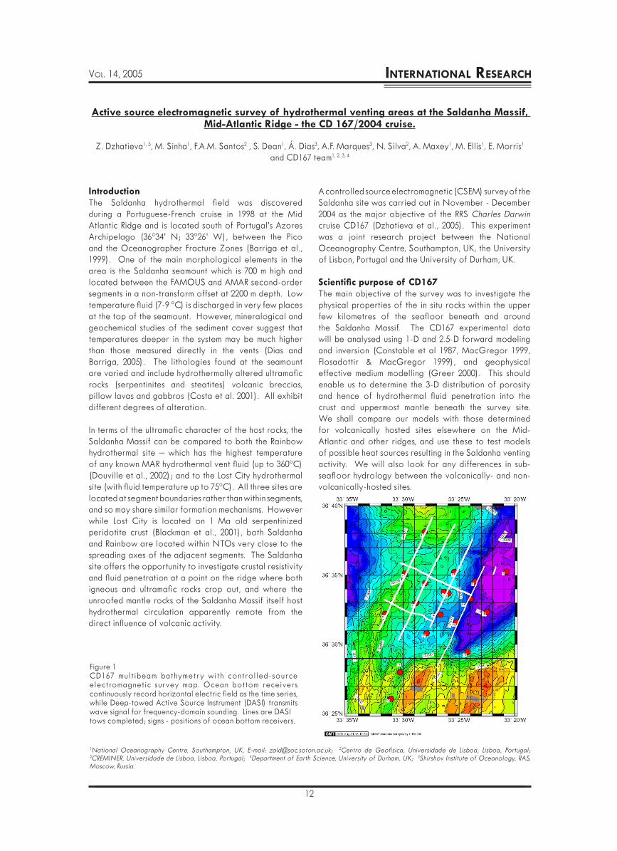
Figure 1CD167 multibeam bathymetry with controlled-source electromagnetic survey map. Ocean bottom receivers continuously record horizontal electric field as the time series, while Deep-towed Active Source Instrument (DASI) transmits wave signal for frequency-domain sounding. Lines are DASItows completed; signs - positions of ocean bottom receivers.
IntroductionThe Saldanha hydrothermal field was discovered during a Portuguese-French cruise in 1998 at the Mid Atlantic Ridge and is located south of Portugal’s Azores Archipelago (36º34’ N; 33º26’ W), between the Pico and the Oceanographer Fracture Zones (Barriga et al., 1999). One of the main morphological elements in the area is the Saldanha seamount which is 700 m high and located between the FAMOUS and AMAR second-order segments in a non-transform offset at 2200 m depth. Low temperature fluid (7-9 ºC) is discharged in very few places at the top of the seamount. However, mineralogical and geochemical studies of the sediment cover suggest that temperatures deeper in the system may be much higher than those measured directly in the vents (Dias and Barriga, 2005). The lithologies found at the seamount are varied and include hydrothermally altered ultramafic rocks (serpentinites and steatites) volcanic breccias, pillow lavas and gabbros (Costa et al. 2001). All exhibit different degrees of alteration.
In terms of the ultramafic character of the host rocks, the Saldanha Massif can be compared to both the Rainbow hydrothermal site – which has the highest temperature of any known MAR hydrothermal vent fluid (up to 360ºC) (Douville et al., 2002); and to the Lost City hydrothermal site (with fluid temperature up to 75ºC). All three sites are located at segment boundaries rather than within segments, and so may share similar formation mechanisms. However while Lost City is located on 1 Ma old serpentinized peridotite crust (Blackman et al., 2001), both Saldanha and Rainbow are located within NTOs very close to the spreading axes of the adjacent segments. The Saldanha site offers the opportunity to investigate crustal resistivity and fluid penetration at a point on the ridge where both igneous and ultramafic rocks crop out, and where the unroofed mantle rocks of the Saldanha Massif itself host hydrothermal circulation apparently remote from the direct influence of volcanic activity.
A controlled source electromagnetic (CSEM) survey of the Saldanha site was carried out in November - December 2004 as the major objective of the RRS Charles Darwin cruise CD167 (Dzhatieva et al., 2005). This experiment was a joint research project between the National Oceanography Centre, Southampton, UK, the University of Lisbon, Portugal and the University of Durham, UK.
Scientific purpose of CD167The main objective of the survey was to investigate the physical properties of the in situ rocks within the upper few kilometres of the seafloor beneath and around the Saldanha Massif. The CD167 experimental data will be analysed using 1-D and 2.5-D forward modeling and inversion (Constable et al 1987, MacGregor 1999, Flosadottir & MacGregor 1999), and geophysical effective medium modelling (Greer 2000). This should enable us to determine the 3-D distribution of porosity and hence of hydrothermal fluid penetration into the crust and uppermost mantle beneath the survey site. We shall compare our models with those determined for volcanically hosted sites elsewhere on the Mid-Atlantic and other ridges, and use these to test models of possible heat sources resulting in the Saldanha venting activity. We will also look for any differences in sub-seafloor hydrology between the volcanically- and non-volcanically-hosted sites.
12
VOL. 14, 2005 INTERNATIONAL RESEARCH

Figure 2Spectrogram for the approx. two-day recording of one of the Low-frequency ElectroMagnetic Underwater Recorders (LEMUR) presents a good signal to noise ratio. The large peak at about 339 dataset occurred when DASI was transmitting along line AA at 0.25 Hz on 13 December. There is some background noise, believed to be caused by both internal and external noises. The scale corresponds to the electric field amplitude.
The ocean bottom receivers used during CD167 record the horizontal electric field as the time series of two electric field components at the seafloor, using two orthogonal horizontal electric dipoles. Each dipole is 13 m long and supports low noise electrodes at the ends of the arms. The arms are weighted with glass rods to minimise motion due to water currents and also to keep the ends of the arms in contact with the seafloor. The sensors are able to measure an electric field signal of 10 picoVolts per metre over the frequency range 0.1 - 60 Hz. The receivers used were a combination of older, ‘Low-frequency Electro Magnetic Underwater Recorder’ (LEMUR) systems which each have a 1 Gb capacity hard disk and 128 Hz sampling rate and a new generation of LC-2000EM receivers, which have a high capacity digital data logger with a 125 Hz sampling rate. All receivers can operate at water depths of up to 6 km. The instrument positions on the seafloor were accurately determined by acoustic ranging and ship-board GPS.
Data CollectedDuring the CSEM survey the transmission lines were mostly towed at a frequency of 0.25 Hz to ensure deep penetration data across the entire survey area. Three profiles were made at 1 Hz, to provide a higher resolution of the resistivity structure in the upper crust. Since the source signal is a square wave, significant amounts of signal are emitted at the third and fifth harmonics. Therefore it should be possible to analyse signals at frequencies of 0.25, 0.75, 1.0, 1.25, 3, and 5 Hz.
Raw data files were initially processed by applying a Fast Fourier Transformation to obtain frequency domain representations. Plotted as a function of elapsed time, these produce spectrograms. Figure 2 shows an amplitude spectrogram for channel 2 of LEMUR 14. The spectrogram reveals distinct peaks which correspond to the DASI transmission frequencies during towing. Background noise levels at other frequencies and at times when no source transmissions are being received are low - this means that a good signal to noise ratio was obtained during the survey. After applying calibration and other corrections, we shall use the frequency domain CSEM dataset as the input to forward and inverse modelling.
SummaryDuring the 3-D CSEM survey the DASI system completed 66 km of electromagnetic survey, transmitting along eight tow tracks over the array of eighteen deployed receivers. Given the experiment geometry and suitable analysis, we expect to be able to construct images of the electrical structure of the Saldanha Massif area down to a depth of about 3 km.
To provide background data for the CSEM study, a set of three current meter moorings, which record current speed and direction, temperature and salinity were deployed across the survey area. Additional data on the
CD167 survey geometryThe survey geometry was designed to provide optimum spatial coverage of both radial and azimuthal field modes. During the survey the Deep-towed Active Source Instrument (DASI) system transmitted electromagnetic signals from a horizontal electric dipole antenna for frequency-domain sounding at 0.25 and 1 Hz. These signals were detected and measured by an array of 17 autonomous ocean-bottom geophysical recorders deployed in a 10 km2 grid centred on the Saldanha Massif.
Eight transmission lines were towed along a set of four N-S and two E-W tow lines across the survey area (Figure 1). This survey geometry gives source - receiver ranges of up to 14 km and so should provide information on the resistivity structure to a depth of about three kilometres beneath the seafloor.
Cruise instrumentationThe DASI transmitter emits a continuous wave signal for frequency-domain sounding over a range of 0.1 - 256 Hz, with most energy at the fundamental frequency and its third and fifth harmonic (Sinha 1990). The transmitting horizontal electric dipole antenna is 100 m long, neutrally buoyant, and streams behind the DASI vehicle. The antenna is earthed into seawater at both ends using copper cable electrodes placed at 30 m and 130 m behind the vehicle. All transmissions were made with a peak-to-peak current of approximately 200 A. Transmission parameters such as frequency and current are controlled from the ship via a fibre optic cable. The tow tracks of the DASI system were determined using ship-based ultra-short baseline navigation (USBL, Sonardyne) and ship GPS.
13
INTERRIDGE NEWSINTERNATIONAL RESEARCH

physical properties of the water column were obtained using 14 expendable bathythermographs (XBT) and a sound velocity meter profile. Between the start and end of the survey, gravity data were collected continuously, and total field magnetic data for part of the time, giving gravity and magnetic profiles across the ridge. During the cruise the whole survey area was remapped with Simrad EM12 swath bathymetry. To investigate the history of hydrothermal activity eleven short sediment gravity cores were collected on and around the Saldanha massif, with nine of these providing valuable material. Four dredges were attempted for hard rock samples from sites around the Massif, and two of these were retrieved with samples.
The data collected during CD167 should result in images of the electrical resistivity structure which, in turn, will be translated into constraints on pore space distribution and interconnectedness as well as pore fluid properties. We shall use these results to investigate whether the Saldanha vent site owes its existence to the presence of a deep fracture network, extending downwards into the underlying mantle rocks and to test models of possible hydrothermal heat sources.
AcknowledgementsWe thank the RRS Charles Darwin crew members and all SOES and UKORS staff involved for their successful and highly professional contributions. Many thanks to Dr. Mathilde Cannat for helping us with the EM12 data. The work was supported by the UK Natural Environment Research Council and the SHEAMA project POCTI/MAR/15281/1999.
ReferencesBarriga, F.J.A.S., 1999. Actividade hidrotermal no fundo
do mar dos Açores: estado da arte. F.C. Gulbenkian, Colóqio/Ciências, 23, 44-59.
Blackman D., J. Karson, D. Kelley et al., Seafloor Mapping and Sampling of the MAR 30°N Oceanic Core Complex – MARVEL 2000. InterRidge News, 2001, V.10, 33-35.
Constable, S.C., R.L. Parker, and C.G. Constable, 1987. Occam’s inversion – a practical algorithm for generating smooth models from electromagnetic data. Geophysics, 52, 289-300.
Dzhatieva, Z., M. Sinha, F. Santos, et al. On Preliminary results of active electromagnetic survey of Saldanha hydrothermal venting field MAR. International MoMAR Implementation Workshop, Lisbon, 2005.
Costa R., Estudo mineralógico e geoquímico da alteração hidrotermal das rochas vulcânicas e ultramáficas serpentinizadas do Monte Saldanha (RMA, segmento FAMOUS/AMAR. MSc Thesis, Faculdade de Ciências da Universidade de Lisboa,, 2001.
Dias. A., F.J.A.S. Barriga. Mineralogy and geochemistry of hydrothermal sediments from the serpentinite-hosted Saldanha hydrothermal field (36º34N; 33º26W) at MAR. Marine Geology 2005 (accepted)
Douville, E., J.-L. Charlou, E.H. Oelkers, P. Bienvenu, C.F. Jove Colon, J.P. Donval, Y. Fouquet, D. Prieur, P. Appriou, 2002. The Rainbow vent fluids (36º14N, MAR): the influence of ultramafic rocks and phase separation on trace metal content in Mid-Atlantic Ridge hydrothermal fluids. Chemical Geology 184, 37–48.
Flosadottir, A.H. and L.M. MacGregor, 1999. Induction Sources in the Ocean: A Model Code for Oceanic and Controlled Sources. EOS, Trans. Amer. Geophys. Union, Supplement, December 1999.
Greer, A., 2000. A joint effective medium method for geophysical properties of two-phase materials. In: S.C. Singh, P.J. Barton, and M.C. Sinha, Eds., Lithos Science Report, March 2000, pp 123-131, University of Cambridge.
MacGregor, L.M., 1999. Marine controlled-source electromagnetic sounding: Development of a regularised inversion 2-Dimensional resistivity structures. In: S.C. Singh, P.J. Barton, andM.C. Sinha, Eds., Lithos Science Report, March 1999, pp 103-109, University of Cambridge.
Sinha, M.C., 1999. Marine controlled-source EM sounding: practical considerations for survey design. The LITHOS Annual Scientific Report. S.C. Singh, M.C. Sinha and P.J. Barton. Cambridge, University of Cambridge: 95-101.
14
VOL. 14, 2005 INTERNATIONAL RESEARCH