vm cl tenure product description1.7...data schema data structure vicmap crown land tenure represents...
TRANSCRIPT

PRODUCT DESCRIPTION
VICMAP CROWN LAND
TENURE
Information Services.
Natural Resources Division,
Department of Sustainability and Environment
Product Description Version 1.7,
June 2007
Accessible either using the Standard data model Version 1.3
or the Basic data model Version 1.1

PRODUCT DESCRIPTION Information Services Natural Resources Division VICMAP CROWN LAND TENURE Version 1.7
VM CL Tenure Product Description1.7.doc
iiii
CONTENTS 1. PRODUCT DESCRIPTION........................................................................................................................... 3
CUSTODIAN ............................................................................................................................................................ 3 JURISDICTION ......................................................................................................................................................... 3 CONTACT INFORMATION......................................................................................................................................... 3
Custodian........................................................................................................................................................... 3 Supply requests .................................................................................................................................................. 3 E-mail enquiries ................................................................................................................................................ 3 General information .......................................................................................................................................... 3 Technical details................................................................................................................................................ 3 Internet site for information............................................................................................................................... 3
DESCRIPTION .......................................................................................................................................................... 4 Geographic extent.............................................................................................................................................. 4 Content .............................................................................................................................................................. 4 Structure ............................................................................................................................................................ 5 Reference systems .............................................................................................................................................. 5 Features of note ................................................................................................................................................. 5 Related data sets ................................................................................................................................................ 5 Reference tables................................................................................................................................................. 6
PRODUCTION AND/OR ACQUISITION METHODS........................................................................................................ 6 Original construction of the dataset .................................................................................................................. 6 On-going maintenance of the data set ............................................................................................................... 6
SOURCE OF INPUT DATA .......................................................................................................................................... 7 GENERALISATIONS WITHIN THE DATA .................................................................................................................... 7 DATA CREATION DATES.......................................................................................................................................... 7 MAINTENANCE AND UPDATE FREQUENCY ............................................................................................................... 7 STANDARDS AND SPECIFICATIONS ......................................................................................................................... 7 LEGISLATIVE REQUIREMENTS................................................................................................................................. 7 CURRENT DATA DEVELOPMENT................................................................................................................... 7 FUTURE PLANS ....................................................................................................................................................... 7 DATA SCHEMA ....................................................................................................................................................... 8
Data structure.................................................................................................................................................... 8 Spatial Data Integrity ...................................................................................................................................... 10
DATA MODEL ....................................................................................................................................................... 11 DATA DICTIONARY............................................................................................................................................... 11 BUSINESS REQUIREMENTS.................................................................................................................................... 12
Access constraints............................................................................................................................................ 12 Exclusion of Liability....................................................................................................................................... 12 Privacy Statement ............................................................................................................................................ 12
SUPPLY AND MEDIA FORMATS AVAILABLE ........................................................................................................... 12 Supply format................................................................................................................................................... 12 Media format ................................................................................................................................................... 14
DATA APPLICATION ....................................................................................................................................... 14 Fitness for purpose .......................................................................................................................................... 14 Areas of application......................................................................................................................................... 14
2. QUALITY OF VICMAP CROWN LAND TENURE ................................................................................ 15
LINEAGE/HISTORY ................................................................................................................................................ 15 DATA QUALITY STATEMENT ................................................................................................................................ 16
In-built procedures to ensure data conformity and accuracy.......................................................................... 16 Non-standard validation exercises undertaken to test conformity and accuracy ............................................ 16
SPATIAL ACCURACY............................................................................................................................................. 18 Positional accuracy ......................................................................................................................................... 18 Relative accuracy............................................................................................................................................. 18
FEATURE AND ATTRIBUTE ACCURACY................................................................................................................. 18 COMPLETENESS .................................................................................................................................................... 18 LOGICAL CONSISTENCY ....................................................................................................................................... 18 POST-PRODUCTION VALIDATION........................................................................................................................... 19

PRODUCT DESCRIPTION Information Services Natural Resources Division VICMAP CROWN LAND TENURE Version 1.7
VM CL Tenure Product Description1.7.doc
iiiiiiii
PROPOSED/REQUIRED QUALITY ASSURANCE APPLICATIONS ............................................................................... 19
3. METADATA.................................................................................................................................................. 20
4. PRICING........................................................................................................................................................ 20
5. ACCESS ......................................................................................................................................................... 20
APPENDIX A......................................................................................................................................................... 21
DATA DICTIONARY......................................................................................................................................... 21
LAYER TABLE STRUCTURE ........................................................................................................................... 21
CL_TENURE_VIEW (POLYGON) ................................................................................................................... 23 CL_TENURE ...................................................................................................................................................... 23 CL_TENURE_CAD_AREA_BDY..................................................................................................................... 24 GOV_ROAD_AREA_BDY ........................................................................................................................................ 25 GOV_ROAD_POLYGON ...................................................................................................................................... 25 GOV_ROAD_CHAIN............................................................................................................................................. 26 APIARY .............................................................................................................................................................. 27
APPENDIX B- DATA MODEL (STANDARD & BASIC) ................................................................................ 28
Production Data Model Classes ...................................................................................................................... 29 Class: spatial_feature...................................................................................................................................... 30 Feature Identification and Tracking................................................................................................................ 30 Class: feature_quality...................................................................................................................................... 31
GLOSSARY ........................................................................................................................................................... 34
PRODUCT DESCRIPTION Information Services VICMAP CROWN LAND TENURE Version 1.7
VM CL Tenure Product Description1.7.doc
3333
1. PRODUCT DESCRIPTION
CUSTODIAN Information Services, Natural Resources Division Department of Sustainability and Environment.
JURISDICTION State of Victoria.
CONTACT INFORMATION
Custodian
Information Services
Natural Resources Division
Department of Sustainability and Environment
Level 3
8 Nicholson Street EAST MELBOURNE Victoria 3002 Australia PO Box 500 East Melbourne 3002 Victoria Australia
Supply requests
• Vicmap Crown Land Tenure is available to Departmental users and,
• Our Vicmap Data Service Providers at www.land.vic.gov.au/vicmapdsp
• or for purchase online at www.land.vic.gov.au/vicmapdata for small areas only, for selected products.
E-mail enquiries
General information
Mark O’Brien phone +61 3 8636 2333 facsimile +61 3 8636 2813 Emil Skender phone +61 3 8636 2333 facsimile +61 3 8636 2813
Technical details
Pauline Kent phone +61 3 9637 9733 facsimile +61 3 9637 8500
Internet site for information
www.land.vic.gov.au/spatial
PRODUCT DESCRIPTION Information Services VICMAP CROWN LAND TENURE Version 1.7
VM CL Tenure Product Description1.7.doc
4444
DESCRIPTION
Geographic extent
Vicmap Crown Land Tenure covers the whole of Victoria.
With the exception of Government Roads that do not cover the Melbourne Metropolitan area.
Content
• Unique Feature Identifiers, date stamps and data quality information.
• Persistent Feature Identifiers, date stamps
• Tenure Identifiers
• Tenure Type Identifiers
• Tenure Code Identifiers
• LGA Code Identifiers
• Parish Code Identifiers (Government Road layer only)
• Dual Status Identifiers (Government Road layer only)
• Z-Level Identifiers for identifying Above, Below or Ground level Tenures.

PRODUCT DESCRIPTION Information Services VICMAP CROWN LAND TENURE Version 1.7
VM CL Tenure Product Description1.7.doc
5555
Structure
• Vector files, Polygon structure with associated line-work
• Topologically structured with Tenure polygon views vertically aligned to each other.
• The data is seamless across the State of Victoria
• Conforms to national data models ie ICSM
Reference systems
The foundation for all spatial information is the geodetic control network, upon which all other data is based. Geodetic Control is the fundamental basis of all Victorian spatial infrastructure, including all other Framework information data sets.
The preferred datum and projection under VGIS are :
• Geocentric Datum of Australia – 1994 Adjustment (GDA94)
− Degrees and decimals of a degree - GDA94 latitude/longitude, or
− Easting and Northings in metres - MGA94 Zone 54 or Zone 55 or VICGRID94.
The Geocentric Datum of Australia has been adopted as the preferred datum by all key agencies of the Australian spatial industry. While AGD66 continues to be accepted and supported in the short term, all spatial data users are urged to develop plans for transition of their systems to GDA94. (Links to official translation parameters and software are available over the web at www.land.vic.gov.au/gda
The native format and projection of Vicmap is in GDA94 in Latitude/Longitude. Data Service Providers will translate this to a number of common datums and projections. The current Vicmap DSP’s are listed at www.land.vic.gov.au/vicmapdsp.
Data users and producers should select the datum/projection/coordinate system most appropriate to their application. For example, VICGRID is better suited than AMG or MGA for whole-of-state of Victoria views, as it minimises distortions.
Features of note
• Unique Feature Identification (each feature is uniquely identified for change management) is managed through the use of two identifier attributes; namely the Persistent Feature identifier (PFI) and the Unique Feature Identifier (UFI).
• Updates are provided as whole file replacement or via Incremental Updating (that is, replacement files are added rather than the whole dataset changed).
• Temporal Data Management (features are date-stamped - data is retired but not deleted).
• Seamless storage of data across the state (non-tiled).
• Tenure, Government Road and Parcel Relationships held aspatially (Link table between Tenure and Parcel attribution tables).
• Under regular maintenance cycle with data supplied from authoritative sources.
Related data sets
Vicmap Crown Land Tenure is not yet part of the State of Victoria’s framework information. VGIS framework information datasets have been delivered into the following Vicmap Products identified below :
• Vicmap Address,
• Vicmap Admin,
• Vicmap Control- SMES,
• Vicmap Elevation,
• Vicmap Features.
• Vicmap Hydro,
• Vicmap Imagery- Satellite,
• Vicmap Position- GPSnet,
• Vicmap Property,
• Vicmap Reference,
• Vicmap Transport,
• Vicmap Vegetation
PRODUCT DESCRIPTION Information Services VICMAP CROWN LAND TENURE Version 1.7
VM CL Tenure Product Description1.7.doc
6666
Reference tables
Reference tables used in the production and maintenance of this data set include: Tenure_Type Tenure
Tenure_Code Dual_Status
LGA_Code Parish_Code
These reference tables are held by Information Services as ‘Oracle’ tables and are available in most database, spreadsheet and delimited formats.
PRODUCTION AND/OR ACQUISITION METHODS
Original construction of the dataset
• Preliminary compilation of the data was through the use of existing large-scale base mapping such as Regional Parish, Township & County Plans (validated as to accuracy and content and updated where required) where available.
• Larger scales (1:500, 1:2,500) were used in urban and town areas, smaller scales (1:10,000, 1:25,000 and 1:50,000) in less dense rural areas.
• Primary capture method was manual marking up of plans and then manual digitising of the marked-up compilations.
On-going maintenance of the data set
• Manual input via bearing & distance;
• Direct input of digital data;
• Manual manipulation to achieve optimum fit – principal directive is to retain the survey geometry, massaging the surrounding data to fit.
• Bulk loading of aspatial data.

PRODUCT DESCRIPTION Information Services VICMAP CROWN LAND TENURE Version 1.7
VM CL Tenure Product Description1.7.doc
7777
SOURCE OF INPUT DATA
• DSE Regional offices,
• Government Gazettes,
• Crown Land Registry,
• Natural Resource Division business units.
GENERALISATIONS WITHIN THE DATA The various Tenure layers can have the following relationships to the Parcel layer;
· 1:1 to Parcel,
· 1 to Many to Parcel,
· Many to 1 to Parcel or
· No direct relationship to Parcel, only direct relationship to Government roads (for example, Unused road licences).
DATA CREATION DATES Data is never deleted, only retired. All key features are tagged with the following attributes to enable an audit trail to be maintained and to facilitate incremental updating:
‘pfi_created (format dd-mm-yyyy hh:mm:ss) is the date/time stamped against each feature when it is created.
‘UFI_created’ (format dd-mm-yyyy hh:mm:ss) is the date/time stamped against each feature when its UFI is created.
‘UFI_superseded’ (format dd-mm-yyyy hh:mm:ss) is the date/time stamped against each feature when/if its UFI is superseded (feature attribute change).
MAINTENANCE AND UPDATE FREQUENCY The data set is current and fully maintained.
STANDARDS AND SPECIFICATIONS Business rules for LCMP_VMD Migration v3.doc
LEGISLATIVE REQUIREMENTS None are applicable.
CURRENT DATA DEVELOPMENT None planned.
FUTURE PLANS • Future upload of aspatial data reports for ease of maintenance.
• Further development of the proposed Reserve Management layer.
• Possible further development of Strata & Jetty Licences.

PRODUCT DESCRIPTION Information Services VICMAP CROWN LAND TENURE Version 1.7
VM CL Tenure Product Description1.7.doc
8888
DATA SCHEMA
Data structure
Vicmap Crown Land Tenure represents real world entities by means of a feature-based data model. Each feature instance reflects only selected properties of an entity type.
The object types below are the primitive components of data contained in the Vicmap Crown Land Tenure. These data objects are grouped together to form a hierarchy which is used for the capture and transfer of the data. The data is topologically structured and additional information about the features will be conveyed by attributes, which are held in attribute tables.
Polygons are used to represent formally bounded area features such as Licences, Leases, Permits, Consents and Reserve boundaries.
Lines are used to represent the boundaries defining such area features, they also provide the graphical definition of linear features such as Pipes and other Linear Tenure licences such as Telecommunications tower sites, Industrial commercial licences.
Points are used to locate symbols, eg. centroids within polygons and unconnected centroids, holding information about the Tenures. They also define the Apiary licence points. They also define the extent of all lines.
Attributes will only reflect selected characteristics of their feature.
PRODUCT DESCRIPTION Information Services VICMAP CROWN LAND TENURE Version 1.7
VM CL Tenure Product Description1.7.doc
9999
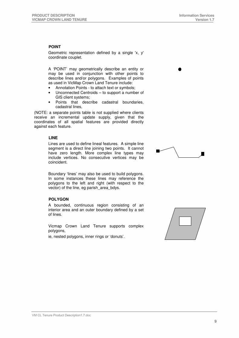
POINT
Geometric representation defined by a single 'x, y' coordinate couplet.
A ‘POINT’ may geometrically describe an entity or may be used in conjunction with other points to describe lines and/or polygons. Examples of points as used in VicMap Crown Land Tenure include:
• Annotation Points - to attach text or symbols;
• Unconnected Centroids – to support a number of GIS client systems;
• Points that describe cadastral boundaries, cadastral lines,
(NOTE: a separate points table is not supplied where clients receive an incremental update supply, given that the coordinates of all spatial features are provided directly against each feature.
LINE
Lines are used to define lineal features. A simple line segment is a direct line joining two points. It cannot have zero length. More complex line types may include vertices. No consecutive vertices may be coincident.
Boundary ‘lines’ may also be used to build polygons. In some instances these lines may reference the polygons to the left and right (with respect to the vector) of the line, eg parish_area_bdys.
POLYGON
A bounded, continuous region consisting of an interior area and an outer boundary defined by a set of lines.
Vicmap Crown Land Tenure supports complex polygons,
ie, nested polygons, inner rings or ‘donuts’.

PRODUCT DESCRIPTION Information Services VICMAP CROWN LAND TENURE Version 1.7
VM CL Tenure Product Description1.7.doc
10101010
Spatial Data Integrity
The spatial data will have no overshoots, undershoots, broken lines or other artefacts of the data capture process as illustrated below.
Undershoot in data:
Correct Representation Incorrect Representation
Overshoot in data:
Correct Representation Incorrect Representation
Broken line in data:
Correct Representation
Incorrect Representation
Artefacts:
spike spike
spike
In most cases, a sudden ‘spike’ in a lineal feature is likely to be an error in the data, an artefact resulting from digitising error or similar cause. However, there are frequent legitimate cases in property detail, where a lineal feature deliberately deviates from a straight linear position and appears to ‘spike’. As it is not possible to investigate whether any/all existing occurrences in the data set are the result of digitising errors or are legitimate cases, users are requested to report such occurrences to Information Services where they know that the depiction is incorrect.
Coincident features
There will be no coincident polygons, lines (whole or in part) or points of the same feature type in the data (also frequently known as “double digitising”). Differing features may contain coincident data. ie Tenure polygons that also form Parcel or Property polygons will be coincident (in these cases the

PRODUCT DESCRIPTION Information Services VICMAP CROWN LAND TENURE Version 1.7
VM CL Tenure Product Description1.7.doc
11111111
common data repeats for each feature class and is appropriately tagged and supplied as part of those features).
DATA MODEL Vicmap Crown Land Tenure is accessible using two different data models. These data models have
been developed in S-Designer Modelling tool and can be located on the Victorian Government website
www.land.vic.gov.au/spatial .
Vicmap Crown Land Tenure using the standard model
The standard model represents Vicmap Crown Land Tenure in its purist form. All of Vicmap Crown
Land Tenure’s tables and attributes with their inherent linkages are provided, but the customer must
perform all the table joins themselves to utilise the data. This model usage is generally suitable for
experienced GIS operators.
It is accessed via any of our Vicmap Data Service Providers at http:///www.land.vic.gov.au/vicmapdsp.
Vicmap Crown Land Tenure using the basic model
The Basic model of Vicmap Crown Land Tenure has joined the Tenure and Tenure Line attributes to
their respective spatial representations (either polygon or lines). It has also decoded numerous codes
within the table - Tenure type codes, Tenure codes, ACT (Parliamentary ACT), LGA codes & Parish
codes. This Basic model has created the links to the Vicmap Reference tables. Whilst this model will be
easier to use, there will still be a requirement for users to perform table joins to obtain relationships
between Parcels in Vicmap Property and Crown Land Tenure
It is accessed online via http://www.land.vic.gov.au/vicmapdata and available for areas up to locality/suburb in size.
DATA DICTIONARY The supporting documentation applicable to both formats of the Vicmap Crown Land Tenure models are also located on the Victorian Governments website www.land.vic.gov.au/spatial.
Refer to Appendix for further details on Data Dictionary.

PRODUCT DESCRIPTION Information Services VICMAP CROWN LAND TENURE Version 1.7
VM CL Tenure Product Description1.7.doc
12121212
BUSINESS REQUIREMENTS
Usage or availability restrictions Product/s will be provided under the terms and conditions of an annual licence.
Licence restrictions/conditions The Vicmap Crown Land Tenure product will be supplied under licence with an annual licence fee determined by the coverage. Details are recorded in a Schedule appended to the Licence. The Licensee may use the
Data only for internal business use. There is no transfer of title or ownership in the Data, and the
copyright and intellectual property in the Data remains the property of the State.
Access constraints
See www.land.vic.gov.au/spatial for standard Data Use Licence Conditions.
Subsidies are available under specific circumstances. - Contact SII for details.
Exclusion of Liability
Information Services make every effort to provide and maintain accurate, complete, useable and timely digital land information. However, some Vicmap Crown land Tenure versions may be preliminary in nature and presented prior to final review and approval by the Director of Natural Resource Division. The data and information are provided with the understanding that they are not guaranteed to be correct or complete. Users are cautioned to consider carefully the provisional nature of the data before using it for decisions that concern personal or public safety or the conduct of business that involves substantial monetary or operational consequences. Conclusions drawn from, or actions undertaken on the basis of this data are the sole responsibility of the user.
Information Services does not warrant that this Product Description and the data are free from errors or omissions. Also, Information Services shall not be in any way liable for any loss, damage or injury suffered by the licensed user of the data of this Product Description or any other person or organisation consequent upon or incidental to the existence of errors or omissions in the data or this Product Description.
Privacy Statement
The Vicmap product is protected by copyright under the Copyright Act 1968 (Commonwealth). The dataset is appropriately labelled with copyright information and the removal or degradation of this labelling is an offence under the Copyright Amendment (Digital Agenda) Act 2000 (Commonwealth) which came into operation on the 4 March 2001.
The use and distribution of the Vicmap product must comply with the Information Privacy Act 2000 (Vic) and the Privacy Act 1988 (Commonwealth). Significant changes to federal privacy laws will occur when the Privacy Amendment (Private Sector) Act 2000 (Commonwealth) comes into force on 21 December 2001. Users will have to comply with this legislation.
SUPPLY AND MEDIA FORMATS AVAILABLE
Supply format
• DXF File
• Intergraph.DGN
• ESRI ‘SHAPE’ files
• DWG (AutoCAD)
• MapInfo

PRODUCT DESCRIPTION Information Services VICMAP CROWN LAND TENURE Version 1.7
VM CL Tenure Product Description1.7.doc
13131313
• Incremental Update - (Refer to the Victorian Government website land.vic.gov.au/spatial for details regarding the IUF Model and supporting documentation.

PRODUCT DESCRIPTION Information Services VICMAP CROWN LAND TENURE Natural Resources Division Version 1.7 Appendix A
VM CL Tenure Product Description1.7.doc
14141414
Media format
• CD-ROM
• DVD
Projections • Native projection- Geocentric Datum of Australia – 1994 Adjustment (GDA94)
− Degrees and decimals of a degree - GDA94 latitude/longitude
• Others on request
Other formats, media and projections available upon application.
DATA APPLICATION
Fitness for purpose
Although some higher order accuracies occur in pockets, the data is primarily derived from mapping compiled at 1:480 and 1:500 (metropolitan Melbourne), 1:2,500, 1:10,000 and 1:25,000 scales. Use of the data is therefore logically suited to applications at the same or smaller scale to that of the source. Any enlargement or extrapolation of the data will result in proportionally increased visual displacement and/or errors of the same order of magnitude in any analytical outcomes.
Areas of application
• Identification of Crown land Tenure and management
• Strategic Planning
• Project planning
• Research systems
• Asset management
• Real Estate management
• Valuations analysis
• Property analysis / proximity search
• Graphical index
Note: Most applications will require the input of user-specific data, eg planning polygons, land use information, sales and/or valuation figures, etc.

PRODUCT DESCRIPTION Information Services VICMAP CROWN LAND TENURE Natural Resources Division Version 1.7 Appendix A
VM CL Tenure Product Description1.7.doc
15151515
2. QUALITY OF VICMAP CROWN LAND TENURE
LINEAGE/HISTORY Vicmap Crown Land Tenure is derived from what were originally two logically and physically separated databases, which is now known as Vicmap Property. Melbourne Water created a digital data set covering the Melbourne Metropolitan area. Survey and Mapping Victoria created a similar data set covering rural Victoria. Both data sets consisted of “spaghetti” line work (that is, unintelligent data).
The Metropolitan Base was created as a reference framework for Melbourne Water's Asset and reflected Melbourne Water's business needs by holding subdivisions at both the proposed and approved stages. It focused on rateable properties and placed less emphasis on the cadastral changes that did not relate to ‘property’. Primarily, the data was captured by manually digitising Melbourne Water's comprehensive series of 1:480 and 1:500 scale base maps. Digital capture commenced in 1984 and initial coverage was obtained in 1990.
Survey and Mapping’s rural data set reflected a more basic view of land administration, comprising transferable parcels of land. This project entailed a complete re-compilation of the source data, being original Parish plans, registered plans of subdivision and VicRoads survey plans. The process required the production of pencil-plot compilations at a chosen scale of 1:2,500 over towns and built- up areas (using survey-acquired control) and 1:25,000 for the balance of the state (using existing standard Vicmap 1:25,000 topographic mapping as control). In a small number of areas, where existing base mapping could be used or where compilation at 1:25,000 was impractical (eg along the Murray River and parts of South Gippsland), mapping at 1:10,000 was produced. Where other authorities’ (Local Government or Water Boards) mapping at similar or better scale and accuracy was found, it was adopted or upgraded and used in preference to producing new compilations. Apart from a small number of maps compiled directly to digits, these pencil plots were also hand-digitised. Digital capture of the balance of Victoria, beyond the Metropolitan area, started in 1983 with Statewide coverage being obtained in December 1994.
Both data sets were eventually brought under control of a single authority, that of the Office of Geographic Data Co-ordination (OGDC). Key challenges for OGDC were to provide a common structure to the data and to standardise the maintenance. Government restructures have since seen administration changes through Geographic Data Victoria (GDV) to Land Victoria, but management of the data has remained stable. Throughout this time, significant changes to the data (its structure, quality, content and maintenance) have occurred, one of the most noteworthy being the out-sourcing of data maintenance to a non-government agency. Whilst full control and administration of the data remains with Spatial Information Infrastructure, Vicmap Property is now maintained by LogicaCMG Pty. Ltd.
Over the past six years Vicmap Property has evolved as a fully maintained database within an Oracle environment that provides a graphical representation of virtually all land parcels within Victoria together with considerable attribute information associated with these parcels. The database currently includes some 95% of all Crown Land parcels as a result of an initial correlation with the LIMS Cadastral Mapping Program (LCMP) Parcel layer several years ago. Through these improvements implemented by Spatial Information Infrastructure, Vicmap Property has become accepted across all levels of government and the Utilities as a credible reference framework for asset recording and land administration in general.
The Crown Land Management mapping system (LCMP) has been in existence since the early 1990’s and has provided a key database in the management of Crown Land. Considerable effort has been made over the years to ensure the integrity of the details pertaining to Crown Land parcels and the various Private Use Tenure & Reserve boundaries held within the database. The spatial framework for the system has been the predecessor to Vicmap Property dating back to the early 1990’s and whilst

PRODUCT DESCRIPTION Information Services VICMAP CROWN LAND TENURE Natural Resources Division Version 1.7 Appendix A
VM CL Tenure Product Description1.7.doc
16161616
both systems were derived from the same source, considerable differences now exist between the two cadastral reference frameworks.
Some effort was also made several years ago to correlate, at least in part, the Crown Land parcels in Vicmap Property with the more authoritative data within the LCMP Parcel layer. Notwithstanding this effort, considerable differences still exist in terms of completeness and spatial representation (i.e. shape and position).
As a result of the two systems, there existed conflicting information with regards to Crown Parcels and also duplicative maintenance processes, at least in part. (i.e. Vicmap Property did not store the Tenure, Reserve and Government Road boundaries). With the widespread acceptance of Vicmap Property throughout Government and in particular it’s increased availability throughout DSE/DPI, it was resolved by Land Victoria to integrate the maintenance of Crown Land into the maintenance processes of Vicmap Property.
The LCMP Tenure layers, also known as “business layers”, consisted of the following: Aglic, Lease, General, Pipe, Reserve and Government Roads. Apiary is a point dataset that is maintained by Regional staff, but is also included as part of the Vicmap Crown Land Tenure product.
The inclusion of Crown Land Management’s Tenure, Reserve and Government Road boundaries into Vicmap was a Data Migration project that started in July 2003 and concluded in February 2004. The maintenance is now streamlined and provides a more comprehensive view of Crown Land and its management.
DATA QUALITY STATEMENT The magnitude of this data set, the complexity of its content, and the multiplicity of its sources in both initial construction and ongoing maintenance, means that there is still a great deal of non-compliant data to be found and corrected. Notwithstanding this, the quality of Vicmap Crown Land Tenure is highly compliant with its technical specification.
The diverse nature of the data sets from which Vicmap Crown Land Tenure was derived has set a significant challenge to Information Services to meet the rapid and continually changing nature of the requirements placed on this data set. To this end, not only is new data subject to rigid quality assurance, but increasing resources have been allocated to the task of ensuring that any anomalies or lower standards of the past are rectified.
In-built procedures to ensure data conformity and accuracy
The procedures listed below are undertaken as normal update/maintenance routines, to ensure conformity of the data to the technical specification:
• Virus check software for digitally-supplied input data;
• Procedure manual including input check-list to guide operator;
• Use of operator ‘pick-lists’ for standard inputs (eg tenure_type_code);
• Software application to confirm topology and form polygons;
• Validation of accepted types according to approved reference tables;
• 5% of all maintenance updates processed are separately audited by Crown Land Management to confirm accuracy, completeness and correctness in the capture process.
Non-standard validation exercises undertaken to test conformity and accuracy
The following non-standard exercises have been undertaken, at the date noted, to identify errors and non-conformities for remediation:

PRODUCT DESCRIPTION Information Services VICMAP CROWN LAND TENURE Natural Resources Division Version 1.7 Appendix A
VM CL Tenure Product Description1.7.doc
17171717
• 2003 – 2004, migration of Crown Land Tenure data to align with Vicmap Property boundaries.
• 2005, Data Quality reporting tool implemented, reports checked fortnightly.

PRODUCT DESCRIPTION Information Services VICMAP CROWN LAND TENURE Natural Resources Division Version 1.7 Appendix A
VM CL Tenure Product Description1.7.doc
18181818
SPATIAL ACCURACY
Positional accuracy
Vicmap Crown Land Tenure is classified as “BB” accuracy. That is, 90% of well-defined features are within 1mm (at plot scale) of their true position, eg 1:500 equates to +/- 0.5metre and 1:25,000 equates to +/- 25 metres. Anecdotal evidence suggests that the spatial accuracy of the major part of the data set (at all scales) is frequently better than BB.
Where subdivisions have been submitted in digital form, the “survey accurate” data has been used to extend the accuracy of the surrounding detail. This information has not been included in the precision attribute but a proposal is being considered to populate the precision value for every point that describes the cadastral boundaries (on which Vicmap Crown Land Tenure boundaries are based).
Relative accuracy
No “shift” of data as a means of “cartographic enhancement” to facilitate presentation has been employed for any real world feature.
FEATURE AND ATTRIBUTE ACCURACY For this product, feature and attribute accuracy is a measure of the degree to which the features and attribute values of spatial objects agree with the information on the source material. The allowable error in attribute accuracy ranges between a 1% (for new data additions) to 5% (for pre-maintenance contract data).
COMPLETENESS Reliability figures indicating completeness of content between the data set and real world:
Data feature Estimated completeness of content (%)*
Metropolitan Rural
Agricultural Licences 95 90
Leases 95 95
General Licences 95 80
Pipes 95 95
Reserves 90 90
Government Roads Not compiled 95
*The above figures are believed to be reasonable estimates of accuracy. They are anecdotal, sometimes supported by limited feature and/or attribute comparisons with other data sets. They have not been confirmed through statistical methodologies.
LOGICAL CONSISTENCY Logical consistency is a measure of the degree to which data complies with the technical specification. The allowable error in logical consistency ranges between 3% (new data additions) to 5% (pre-maintenance contract data). The test procedures are a mixture of software scripts and on-screen, visual checks.
PRODUCT DESCRIPTION Information Services VICMAP CROWN LAND TENURE Natural Resources Division Version 1.7 Appendix A
VM CL Tenure Product Description1.7.doc
19191919
POST-PRODUCTION VALIDATION The following post-production validation exercises have been undertaken to ensure that no detail has been lost as a result of the capture process:
• A (very) small number of points have been field validated for positional accuracy using “GPS”. All values, when related back to the base data, surpassed the requirements of ‘BB’ accuracy.
• Property descriptions are being extensively validated against local government records on an ongoing basis.
• Customer feedback provides an ongoing form of validation. Advice Improvement notices (M2 forms - Refer to Appendix A) specify issues Customers identify with the Vicmap Crown Land Tenure product and are forwarded to Information Services for investigation and, where required, rectification.
• Existing data content is checked for attribute accuracy; inconsistencies are being systematically identified and removed, eg plan number prefixes, plan number ranges.
PROPOSED/REQUIRED QUALITY ASSURANCE APPLICATIONS Information Services are continually improving and extending the quality and content of the base. Information Services in conjunction with SII, will continue to undertake and improve its Quality Assurance processes to ensure that they conform to Australian and International Standards, and continue to improve the quality of the data within the Products.

PRODUCT DESCRIPTION Information Services VICMAP CROWN LAND TENURE Natural Resources Division Version 1.7 Appendix A
VM CL Tenure Product Description1.7.doc
20202020
3. METADATA Metadata at Page 0 level has been created using a compliant metadata entry tool, and has been added to the Victorian Spatial Data Directory (VSDD). VSDD entries may be viewed via Land Victoria’s website at www.land.vic.gov.au/spatial or via the Australian Spatial Data Directory site at http://www.auslig.gov.au/asdd/.
The metadata complies with the Geospatial Information Metadata Guidelines for Victoria - part of the Victorian Geospatial Information Strategy 2000-2003. Page 1 and Page 2 metadata is pending definition of the elements for each Page level.
4. PRICING The Victorian government has a policy of full cost recovery for all products and services, unless there is a specific policy direction to the contrary. For this dataset, Information Services purely wants to cover the costs of maintenance.
The existing pricing policy for spatial information products is set out in the Victorian Geospatial Information Strategy 2000-2003 (VGIS). For details see the Land Channel website www.land.vic.gov.au/spatial. In brief, the pricing policy for Vicmap has two objectives:
• pricing should not be an impediment to use; and
• revenue should be adequate to provide for the maintenance and development of Vicmap, to the standard required by its users.
5. ACCESS Vicmap is distributed by Data Service Providers (DSPs), with DSE taking a wholesale role. The objective of this approach is to promote industry development, allowing DSE to focus on production and development while DSPs focus on marketing and sales. There is a small group of users who obtain Vicmap products directly from DSE, generally as a result of an existing contractual arrangement or agreement.
Some Vicmap data for small packet geographical areas can be accessed directly from the Land Channel website on http://www.land.vic.gov.au/vicmapdata. Customers wishing to access larger areas or with special requirements should contact a DSP. Multiple DSPs have been engaged to provide a competitive market. DSP’s are listed on the Land Channel website on http://www.land.vic.gov.au/dsp
All digital data issued to customers is subject to licence conditions. A copy of the terms and conditions of the Licence can be viewed on the Land Channel website at www.land.vic.gov.au/spatial under Products and then under Licence for use of Vicmap
In general the User Licence allows licensees to use the data within their own business but does not permit data to be provided to third parties. There is no transfer of intellectual property in the data to customers.
Commercial or DSP licences are separate to user licences.

PRODUCT DESCRIPTION Information Services VICMAP CROWN LAND TENURE Natural Resources Division Version 1.7 Appendix A
VM CL Tenure Product Description1.7.doc
21212121
APPENDIX A
DATA DICTIONARY
OVERVIEW OF TABLES AND THEIR INCLUDED FIELDS
Vicmap – CL Tenure is maintained under contract to Land Victoria by LogicaCMG Pty. Ltd. The data set is held in Oracle®, the spatial component of which is managed by ESRI’s ArcSDE®. This document sets out the layers, entities, attribute tables, and fields within these tables that comprise the Vicmap CL Tenure product data set. Those tables containing information are indicated below. It should be recognised however, that not all fields are populated at this time. The completion of any specific field varies depending on information availability and capture program. For update information access www.land.vic.gov.au/spatial under State Digital Map Base.
This table details the feature types; entity types and attributes applicable to each of the layers within the CL Tenure theme.
Layer Entity Attribute Relationships
LAYER TABLE STRUCTURE Table List
Table Name Comment
APIARY All points which represent Beefarm & Apiary licences.
CAD_AREA_BDY All cadastral boundaries, which make up properties and/or parcels
CAD_LINE CAD_LINE represents boundaries within the cadastral framework including easements
boundaries and government road boundaries.
CENTROID Spatial table containing centroid information related to the Parcel and Property polygons
CL_TENURE Aspatial table containing Crown Land Tenure identifiers
CL_TENURE_CAD_AREA_BDY
Link table between Crown Land Tenure View and Cad Area Bdy
CL_TENURE_PARCEL Link table between Parcel and Crown Land Tenure
CL_TENURE_VIEW Spatial Representation of Crown Land Tenure
GOV_ROAD_AREA_BDY Spatial representation of Government Road boundaries as lines
GOV_ROAD_CHAIN Link table between GOV_ROAD_POLYGON (polygon) and GOV_ROAD_AREA_BDY (lines)
GOV_ROAD_POLYGON Spatial representation of Government road network casements
PARCEL Aspatial table containing the Parcel Identifiers

PRODUCT DESCRIPTION Information Services VICMAP CROWN LAND TENURE Natural Resources Division Version 1.7 Appendix A
VM CL Tenure Product Description1.7.doc
22222222
Domain List
Domain Name Data Type Comment
CROWN_STATUS VARCHAR2(1) A code that identifies a characteristic of the crown description.
Valid codes are (C)rown land, Pre-(E)mptive Right, (K) Crown Special Survey, (M) Parcels identified by Further Description Only and (V)ested Land.
DESC_TYPE VARCHAR2(2) A code to identify the origin of the parcel identifier.
(12) for Multi Parcel, (14) for Crown Descriptions and (15) for Plan
Descriptions.
FEATURE_CODE VARCHAR2(6) Feature codes
See reference Table: VP_FEATURE.FCODE
FEATURE_QUALITY_ID
VARCHAR2(20) Feature Quality Identifier
FEATURE_TYPE VARCHAR2(6) Feature codes
See reference Table: VP_FEATURE.FCODE
JOB VARCHAR2(10)
LGA_CODE VARCHAR2(3) Local Government Area (LGA) code: See Reference Table: LGA.LGA_CODE
PARISH_CODE VARCHAR2(4) Parish codes
See Reference Table: PARISH.PARISH_CODE
PART VARCHAR2(1) A code to identify parcels that have been subject to transfers out to part. Valid Codes are (N)o and (P)art
PFI VARCHAR2(10) Persistent Feature Identifier is not changed when attribute values of the object are changed or minor changes to the geometry are made.
PFI_CREATED DATE Date Persistent Feature Identifier (PFI) was created.
PLAN_NUMBER VARCHAR2(9) A unique identifier for a plan registered on the Victorian On-line Titles System (VOTS), consisting of a plan type and number
See Reference Table: VP_PLAN.NUMBER
SOURCE VARCHAR2(2) 2 digit code representing cadastral co-ordinate capture source
See Reference Table: VP_POINTS_SOURCE
SPI VARCHAR2(18) Standard Parcel Identifier
STATUS VARCHAR2(1) A code that identifies whether the feature is (A)pproved or (P)roposed
TENURE_CODE VARCHAR2(3) The Tenure code associated with Crown Land Tenures. The range of the Tenure codes is from 100 - 999.
See Reference Table: CL_TENURE_CODE.TENURE_CODE
TENURE_ID VARCHAR2(7) A Unique Identifier for Crown Land Tenures sourced from Crown Land Management's Text database.
TENURE_TYPE VARCHAR2(2) Code that identifies the different types of Crown Land Tenure. Valid codes are (A)glic, (L)ease, (G)eneral, (P)ipeline, (RS) Reserve Status, and (RM) Reserve Management.
See Reference Table: CL_TENURE_TYPE_CODE.TENURE_TYPE_CODE
TOWNSHIP_CODE VARCHAR2(5) Township codes
See Reference Table: TOWNSHIP.TOWNSHIP_CODE
UFI
NUMBER(10) Unique Feature Identifier
UFI_CREATED DATE Date Unique Feature Identifier (UFI) was created.
UFI_SUPERSEDED DATE Date Unique Feature Identifier (UFI) was superseded.
YES_NO VARCHAR2(1) A flag indicating if the attribute contains these characteristics. Valid values are (Y)es or (N)o.
Z_LEVEL VARCHAR2(10) A property/parcel may be (B)elow ground, at (G)round level or (A)bove ground.

PRODUCT DESCRIPTION Information Services VICMAP CROWN LAND TENURE Natural Resources Division Version 1.7 Appendix A
VM CL Tenure Product Description1.7.doc
23232323
CL_TENURE_VIEW (POLYGON)
Summary information
Name CL_TENURE_VIEW
Code CL_TENURE_VIEW
Comment Spatial representation of CL Tenure
TABLE: CL_TENURE_VIEW
TABLE DESCRIPTION:
COLUMN NAME DATA TYPE Domain COLUMN DESCRIPTION
CENTROID_PFI VARCHAR2(10) PFI Foreign Key to Centroid table
FEATURE_QUALITY_ID VARCHAR2(20) FEATURE_QUALITY_ID
Data Quality Pointer
FEATURE_TYPE VARCHAR2(6) FEATURE_CODE
Code for feature type, gives full name, scale, and all display characteristics
PFI VARCHAR2(10) PFI Persistent Feature Identifier (PFI)
PFI_CREATED DATE PFI_CREATED The date the Persistent Feature Identifier was created.
UFI NUMBER(10) UFI Database wide Unique Feature Identifier; 6 char State database, 9 char local ID
UFI_CREATED DATE UFI_CREATED Date UFI created
UFI_OLD NUMBER(10) UFI UFI of feature prior to last edit
Z_LEVEL VARCHAR2(10) Z_LEVEL A unique code to identify the parcels proximity to surface level. Above Ground, Surface Level & Below Ground
KEYS in CL_TENURE_VIEW:
Key name Comment Primary
CL_TENURE_VIEW TRUE
INDEXES in CL_TENURE_VIEW:
Index name Comment Unique
Primary
For Key
Alt Key
PARCEL_VIEW_FK1 FALSE FALSE FALSE FALSE
PARCEL_VIEW_PK TRUE TRUE FALSE FALSE
CL_TENURE
Summary information
Name CL_TENURE
Code CL_TENURE
Comment Aspatial table containing Crown Land Tenure identifiers.
TABLE: CL_TENURE

PRODUCT DESCRIPTION Information Services VICMAP CROWN LAND TENURE Natural Resources Division Version 1.7 Appendix A
VM CL Tenure Product Description1.7.doc
24242424
TABLE DESCRIPTION:
COLUMN NAME DATA TYPE Domain COLUMN DESCRIPTION
FEATURE_QUALITY_ID VARCHAR2(20) FEATURE_QUALITY_ID
Data Quality Pointer
LGA_CODE VARCHAR2(3) LGA_CODE A unique code to identify the Local Government Area (LGA)that the Crown Land tenure nominally falls within.
PFI VARCHAR2(10) PFI Persistent Feature Identifier (PFI)
PFI_CREATED DATE PFI_CREATED The date the Persistent Feature
Identifier was created
TENURE_CODE VARCHAR2(3) TENURE_CODE The Tenure code associated with Crown Land Tenures. The range of the Tenure codes is from 100 - 999.
See Reference Table: CL_TENURE_CODE.TENURE_CODE
TENURE_ID VARCHAR2(7) A Unique Identifier for Crown Land Tenures sourced from Crown Land Management's Text database.
TENURE_TYPE VARCHAR2(2) TENURE_TYPE Code that identifies the different types of Crown Land Tenure. Valid codes are (A)glic, (L)ease, (G)eneral, (P)ipeline, (RS) Reserve Status, and
(RM) Reserve Management.
See Reference Table:
CL_TENURE_TYPE_CODE.TENURE_TYPE_CODE
UFI NUMBER(10) UFI Database wide Unique Feature Identifier; 6 char State database, 9 char local ID
UFI_CREATED DATE UFI_CREATED Date UFI created
UFI_OLD NUMBER(10) UFI UFI of feature prior to last edit
KEYS in CL_TENURE:
Key name Comment Primary
CL_TENURE TRUE
CL_TENURE_CAD_AREA_BDY
Summary information
Name CL_TENURE_CAD_AREA_BDY
Code CL_TENURE_CAD_AREA_BDY
Comment Link table between Crown Land Tenure View and Cad Area Bdy.
TABLE: CL_TENURE_CAD_AREA_BDY
TABLE DESCRIPTION:
COLUMN NAME DATA TYPE Domain COLUMN DESCRIPTION
BND_PFI VARCHAR2(10) PFI Foreign Key linking Lower
Geometric Entity (Polygon to Line)
UFI_CREATED DATE UFI_CREATED Date UFI created
VIEW_PFI VARCHAR2(10) PFI Foreign Key to Higher Geometric
INDEXES in CL_TENURE_CAD_AREA_BDY:

PRODUCT DESCRIPTION Information Services VICMAP CROWN LAND TENURE Natural Resources Division Version 1.7 Appendix A
VM CL Tenure Product Description1.7.doc
25252525
Index name Comment Unique
Primary
For Key
Alt Key
PARCEL_MAPPOLY_FK2 FALSE FALSE FALSE FALSE
PARCEL_MAPPOLY_FK1 FALSE FALSE FALSE FALSE
GOV_ROAD_AREA_BDY
Summary information
Name GOV_ROAD_AREA_BDY
Code GOV_ROAD_AREA_BDY
Comment Spatial Representation Of Government Road boundaries as lines.
TABLE: GOV_ROAD_AREA_BDY
TABLE DESCRIPTION:
COLUMN NAME DATA TYPE Domain COLUMN DESCRIPTION
FEATURE_QUALITY_ID VARCHAR2(20) FEATURE_QUALITY_ID
Data Quality Pointer
FEATURE_TYPE VARCHAR2(6) FEATURE_CODE Code for feature type, gives full name, scale, and all display characteristics
PFI VARCHAR2(10) PFI Persistent Feature Identifier (PFI)
PFI_CREATED DATE PFI_CREATED The date that the persistent Feature Identifier was created
UFI NUMBER(10) UFI Database wide Unique Feature identifier, 6 char State ID and 9 char local ID.
UFI_CREATED DATE UFI_CREATED Date UFI created
UFI_OLD NUMBER(10) UFI UFI of feature prior to last edit
KEYS in GOV_ROAD_AREA_BDY:
Key name Comment Primary
GOV_ROAD_AREA_BDY_KEY TRUE
INDEXES in GOV_ROAD_AREA_BDY:
Index name Comment Unique
Primary
For Key
Alt Key
PARISH_AREA_BDYS_PK TRUE TRUE FALSE FALSE
GOV_ROAD_POLYGON
Summary information
Name GOV_ROAD_POLYGON
Code GOV_ROAD_POLYGON
Comment Spatial representation of Government Road network easements.

PRODUCT DESCRIPTION Information Services VICMAP CROWN LAND TENURE Natural Resources Division Version 1.7 Appendix A
VM CL Tenure Product Description1.7.doc
26262626
TABLE: GOV_ROAD_POLYGON
TABLE DESCRIPTION:
COLUMN NAME DATA TYPE Domain COLUMN DESCRIPTION
DUAL_STATUS VARCHAR2(1) YES_NO Indicates if the Government road has dual status: Valid values are (Y)es or (N)o.
FEATURE_QUALITY_ID VARCHAR2(20) FEATURE_QUALITY_ID
Data Quality Pointer
FEATURE_TYPE VARCHAR2(6) FEATURE_CODE Code for feature type, gives full name, scale, and all display characteristics
PARISH_CODE VARCHAR2(4) PARISH_CODE 4 digit parish code identifying the Parish (range2001-4005)
PFI VARCHAR2(10) PFI Persistent Feature Identifier (PFI)
PFI_CREATED DATE PFI_CREATED The date the Persistent Feature Identifier was created
UFI NUMBER(10) UFI Database wide Unique Feature Identifier; 6 char State database, 9 char local ID
UFI_CREATED DATE UFI_CREATED Date UFI created
UFI_OLD NUMBER(10) UFI UFI of feature prior to last edit
KEYS in GOV_ROAD_POLYGON:
Key name Comment Primary
GOV_ROAD_KEY TRUE
INDEXES in GOV_ROAD_POLYGON:
Index name Comment Unique
Primary
For Key
Alt Key
PARCEL_VIEW_FK1 FALSE FALSE FALSE FALSE
PARCEL_VIEW_PK TRUE TRUE FALSE FALSE
GOV_ROAD_CHAIN
Summary information
Name GOV_ROAD_CHAIN
Code GOV_ROAD_CHAIN
Comment Link table between GOV_ROAD_POLYGON (polygon) and GOV_ROAD_AREA_BDY (lines).
TABLE: GOV_ROAD_CHAIN
TABLE DESCRIPTION:
COLUMN NAME DATA TYPE Domain COLUMN DESCRIPTION
BND_PFI VARCHAR2(10) PFI Foreign key linking to the boundary (line) spatial layer
POLYGON_PFI VARCHAR2(10) PFI Foreign key linking to the Government Road Polygon
UFI_CREATED DATE UFI_CREATED Date UFI created

PRODUCT DESCRIPTION Information Services VICMAP CROWN LAND TENURE Natural Resources Division Version 1.7 Appendix A
VM CL Tenure Product Description1.7.doc
27272727
APIARY
Summary information
Name APIARY
Code APIARY
Comment Aspatial table containing Crown Land Tenure identifiers for Apiary sites.
TABLE: CL_TENURE
TABLE DESCRIPTION:
COLUMN NAME DATA TYPE Domain COLUMN DESCRIPTION
PFI VARCHAR2(10) PFI Persistent Feature Identifier (PFI)
TENURE_ID VARCHAR2(7) A Unique Identifier for Crown Land Tenures sourced from Crown Land Management's Text database.
TENURE_CODE VARCHAR2(3) TENURE_CODE The Tenure code associated with Crown Land Tenures. The range of the Tenure codes is from 100 - 999.
See Reference Table: CL_TENURE_CODE.TENURE_CODE
RADIUS NUMBER (4) A permanent Beefarm & Range licence has a radius of 1600m and a Temporary Apiary right has a radius of 800m.
UFI_CREATED DATE UFI_CREATED Date UFI created

PRODUCT DESCRIPTION Information Services VICMAP CROWN LAND TENURE Natural Resources Division Version 1.7 Appendix A
VM CL Tenure Product Description1.7.doc
28282828
APPENDIX B- DATA MODEL (STANDARD & BASIC)
Refer to property_crown_land_tenure_v1.3 pdf file for Standard model diagram.
Refer to property_crown_land_tenure_v1.0 pdf file for Basic model diagram.
Refer to property_crown_land_tenure_v1_report pdf file for data dictionary.

PRODUCT DESCRIPTION Information Services VICMAP CROWN LAND TENURE Natural Resources Division Version 1.7 Appendix A
VM CL Tenure Product Description1.7.doc
29292929
Identifiers
The data model caters for unique identifiers to conform to the ICSM standard (PFI + retire_date_ufi) and also provide support for the existing unique identifier for the SDRN database (UFI). Therefore the Primary Key of (PFI + retire_date_ufi) and a supplementary unique key (UFI), is provided for all spatial objects.
All PFI’s for spatial objects are drawn from the same domain (Numeric), therefore ensuring that all spatial features have consistent identification without hidden meaning within the domain.
Theme
The logical data model is divided into subject areas or themes. Each of the logical themes is arranged in suitable generalised hierarchies of like features ie. Hydrography, Infrastructure, Transport,
As a general rule, features within a theme are grouped into layers, based on the similarity of their attributes.
Theme – Layer – Entity Relationship
The table below details the entities associated with the Vicmap Crown Land Tenure Theme/Layer.
Production Data Model Classes
Topology Storage
Spatial entities are stored in layers according to their basic primitive geometry type, being one of the following: -
LINE AND CENTROID (UNFORMED POLYGONS)
LINE AND CENTROID (FORMED POLYGONS)
LINE AND POINT (LINE - NODE )
POINT
TEXT
To cater for this data storage model, extended topology based attributes are stored on the basic primitive type entities to enable re-building of higher level objects for editing and data extraction activities. These extended attributes are in addition to the standard attributes common to all spatial features.
Common Attributes
The data model supports common attributes for each spatial feature entity in the VICMAP data model plus those attributes needed to support the edit environment and to ensure that the future integrity and development of the model are viable.

PRODUCT DESCRIPTION Information Services VICMAP CROWN LAND TENURE Natural Resources Division Version 1.7 Appendix A
VM CL Tenure Product Description1.7.doc
30303030
Class: spatial_feature
Definition: Definition: Definition: Definition: A spatial feature within the dataset Features: Features: Features: Features: Spatial
Name Definition Data Type Key Mandatory Unique
PFI VICMAP Digital unique identifier for a feature over time (common to all versions of a single feature)
number yes yes
UFI VICMAP Digital unique identifier for a feature
Number yes yes yes
feature_type_code feature code to identify feature type
Character yes
named_feature_id Feature Name Identifier for the feature
number
feature_quality_id Identifier for the feature quality record
number yes
Create_date_pfi Date the PFI originally created
date yes
Superceded_pfi PFI of feature before merge or split operation
number
create_date_ufi Date the ufi was created on
date yes
Feature Identification and Tracking
Feature identification is managed through the use of two identifier attributes, the Persistent Feature identifier (PFI) and the Unique Feature Identifier (UFI).
The PFI is a sequential number allocated to new features at creation and remains with the feature throughout all editing actions. Over time the PFI itself will not be unique within the database as edit actions result in splitting and merging of features.
The UFI attribute will be assigned to new or edited features as maintenance occurs. The UFI attribute will always be unique.

PRODUCT DESCRIPTION Information Services VICMAP CROWN LAND TENURE Natural Resources Division Version 1.7 Appendix A
VM CL Tenure Product Description1.7.doc
31313131
Land Victoria PFI /UFI Applications
The following incremental update attributes are required with behaviour as described:
• PFI – a sequential number applied across the whole VDRT database.
A new PFI is assigned in the following instances:
1. Creation of a new feature, i.e. when a new object is added to the database.
2. When two or more existing features are merged, the final merged feature assumes a new PFI. The old PFIs of the features making up the merged feature are retired.
3. When a feature is split into two or more new features. Each of the new features are assigned a new PFI. The PFI of the original feature is retired.
PFIs do not change when a feature is edited in any other way. i.e. when the following edits are undertaken on features:- 1. Attributes of a feature are modified 2. Physical or spatial representation of a feature is modified.
• UFI - a unique sequential number applied across the whole VDRT database. New UFIs are created on a feature whenever edits are undertaken on the feature.
• Create_date_UFI, The date that a UFI is created on a feature
• Retire_date_UFI, The date that a feature is retired. A feature is retired when any physical change, attribute change, or deletion of a feature occurs.
• Superceded_UFI; This is the UFI of a feature prior to the last edit of the feature
Incremental Update Attributes:
The following Attributes for the new Incremental Update Model for VDRT are:
Attribute Data Type Description
PFI Number Persistent Feature Identifier
Create_date_PFI Date Date that PFI originally created
Retire_date_PFI Date Date that PFI retired as a result of merge, split, or feature discontinuance (deletion)
Superceded_PFI Number PFI of feature before merge or split operation
Create_Type_code Varchar Type of action that caused creation of feature
UFI Number Unique Feature Identifier – assigned at every feature creation or edit
Create_date_UFI Date Date that UFI created
Retire_date_UFI Date Date that UFI retired
Superceded_UFI Number Value of UFI on the feature prior to last edit
Change_Type_code Varchar Type of edit undertaken on feature at last edit
Class: feature_quality
Definition: Defines accuracy and other quality information pertaining to this spatial feature
Features: Aspatial
Name Definition Data Type Code List
Key Mandatory
id IDENTIFIER FOR THE FEATURE
QUALITY RECORD number yes yes
PRODUCT DESCRIPTION Information Services VICMAP CROWN LAND TENURE Natural Resources Division Version 1.7 Appendix A
VM CL Tenure Product Description1.7.doc
32323232
feat_reli_date reliability date for spatial features
date yes
attr_reli_date reliability date attribute date yes
plan_accuracy plan accuracy real yes
elevation_accuracy elevation accuracy real yes
data_sour_code Source Code number yes
scale VICMAP Digital data scale indicating position accuracy
number yes
create_date Date the record was created on date yes
Feature Quality Class AttributesFeature Quality Class AttributesFeature Quality Class AttributesFeature Quality Class Attributes

PRODUCT DESCRIPTION Information Services VICMAP CROWN LAND TENURE Natural Resources Division Version 1.7 Appendix A
VM CL Tenure Product Description1.7.doc
33333333
The Advice Improvement Notice

PRODUCT DESCRIPTION Information Services VICMAP CROWN LAND TENURE Natural Resources Division Version 1.7 Appendix A
VM CL Tenure Product Description1.7.doc
34343434
GLOSSARY Aglic
All Agricultural licence boundaries, including Grazing licences, Water Frontages and Unused road licences, as defined by CLM Regional staff, are included in this layer. The Agricultural licence boundaries have been reconciled against Departmental records. Every record has a legal description attached where possible and a "Tenure number" is recorded in the TENURE_ID field where the area is licensed. The "Tenure number" is used as a key into the Crown Land Management text system (PORTAL) for further details about the Licensee.
The layer is based on the Parcel for Crown land. Agricultural licences may include: Part, Whole or Multiple Crown land Parcels. The boundaries of these have been verified by regional staff against Text data and Regional plans and Files.
Apiary
All Apiary licence centre points, including Bee farm and Range licences and Temporary Apiary rights, as defined by CLM Regional staff, are included in this layer. The Apiary licence boundaries have been reconciled against Departmental records. All records have a "Tenure number" recorded in the TENURE_ID field where the area is licensed. The "Tenure number" is used as a key into the Crown Land Management text system (PORTAL) for further details about the Licensee.
Apiary contains point features defining CLM Bee farm and Range licences and Temporary Apiary rights. The points of these licences have been verified by regional staff against Crown Land Management Text data and Regional plans and Files. This layer is maintained by CLM Regional staff and is another point layer to the Vicmap CL tenure layers.
Approved Parcel
A parcel that has been recorded in either the VOTS as a registered parcel or the Crown Register as a crown owned piece of land.
Aspatial data
Non-spatial data that is usually referenced to spatial data, for example, attributes.
Definition from Association for Geographic Information GIS Dictionary at www.geo.ed.ac.uk/agidexe
Attribute
A particular characteristic or property of an entity. Attributes can be spatial (or locational) and aspatial (or non-locational).
AT
A Crown special description for a localised administrative area identified and surveyed by the State’s early government surveyors as a further breakdown to a larger urban area, eg AT HAWTHORN, PARISH OF BOROONDARA.
Attribute Value
The value assigned to an attribute for a specific feature instance.
Cadastre, Cadastral Base
A public register usually recording the quantity, value and ownership of land parcels in a country or jurisdiction.
AUSLIG at www.auslig.gov.au
CL TENURE
The name given collectively to the following layers; (A)glic, (L)ease, (G)eneral, (P)ipeline, (RS) Reserve Status, and (RM) Reserve Management.

PRODUCT DESCRIPTION Information Services VICMAP CROWN LAND TENURE Natural Resources Division Version 1.7 Appendix A
VM CL Tenure Product Description1.7.doc
35353535
Crown Land
All land owned and held by the State.
Crown Land Management
The group within the previous Land Stewardship & Biodiversity unit (now the Natural Resources Division) responsible for policy, strategy and management associated with all use of Crown Land. Crown Land Management have staff in Regional offices that maintains the Crown Land tenure database and coordinates land use planning and native title issues.
Data
The base level of information stored in electronic databases. Generally, “raw” data has not been value-added.
AUSLIG at www.auslig.gov.au
Entity
A real world phenomenon not divided into phenomena of the same kind.
Feature instance
An abstraction of an entity. The description of a feature instance encompasses only selected properties of that entity. Feature instances can also be referred to as features.
Feature Type
A class of real world phenomena with common properties.
Feature class
A group of feature instances defined by a set of rules and having common attributes and relationships that are properties of the corresponding real world phenomena. Within the Oracle tables that comprise Vicmap Digital Property, classes may refer to “link” tables, which establish direct relationships between the point and/or line and/or polygon structures that may be used as spatial objects.
The feature structure of the feature based data model can be summarised as:
feature instance = [spatial object + attribute object]
Where:
Spatial Object is the addition of all of the locational attributes of the feature instance and may comprise geometrical objects such as points, lines and polygons. Spatial objects carry a spatial address that consists of one or more couplets (x, y) or triplets (x, y, z) of coordinates. In the feature based data model topological relationships will be carried as part of the spatial object whenever the transfer formats support them.
Attribute Object is the addition of non-locational information about a feature instance. These data identify the feature class and the aspatial attributes of a specific instance of the feature type. The attribute object is composed of one or more attributes.
GDA94
The Geocentric Datum of Australia 1994 is based on the Australian Fiducial Network (AFN) which fits into a global geodetic framework. The AFN comprises eight highly accurate survey marks across Australia each with a permanently tracking Global Positioning System (GPS) receiver. It has been established by AUSLIG for geodetic surveying and scientific purposes.
GIS
Geographic Information System. A spatial database which is manipulated with a set of spatial operators or commands.
Government Road
A Government road is a road that has been proclaimed as road in Government Gazettes.

PRODUCT DESCRIPTION Information Services VICMAP CROWN LAND TENURE Natural Resources Division Version 1.7 Appendix A
VM CL Tenure Product Description1.7.doc
36363636
All government roads as determined on parish plans and as defined by CLM Regional staff, are included in this layer. The government road boundaries have been reconciled against Departmental records. The layer is based on the Parcel view.
This layer is frequently used by Departmental officers to determine whether the status of road is government or freehold. Any questions about government road status that can not be resolved at the Regional level are typically resolved by research at the Crown land Registry office (CLR).
The Melbourne Metropolitan area does not currently have Government Roads coverage.
Incremental Update Format (IUF)
A system based on extensible mark-up language (XML) whereby maintenance updates are provided as change only, add/modify/delete incremental update files, between nominated dates/times.
Information Services
Natural Resources Division, Information Services Group (restructured in July 2006 from Asset & Information Management – Information Management Group.)
Land Registry
The group within Land Victoria responsible for providing systems for Victoria’s property market including; the Land Titles Office, Valuer Generals Office, Surveyor Generals Office and Landata.
Land Victoria
A Division within the Department of Sustainable Environment, Land Victoria comprises three main line businesses: Crown Land Management, Land Information Group, and Land Registry. Its role is to develop, maintain and market Victoria’s land information and management and to manage Victoria’s Crown Land.
Land Information Group
The body within Land Victoria responsible for geospatial policy for the State and for providing and maintaining a statewide geospatial infrastructure (includes the Victorian Geodetic Framework and Vicmap Digital). The group is now called Spatial Information Infrastructure.
Lease
All private use leases for commercial purpose boundaries, as defined by CLM Regional staff, are included in this layer. The Lease boundaries have been reconciled against Departmental records. Every record has a "Tenure number" recorded in the TENURE_ID field where the area is licensed. The "Tenure number" is used as a key into the Crown land Management text system (PORTAL) for further details about the Licensee.
The layer is based on the Parcel for Crown land. Leases may include: Part, Whole or Multiple Crown land Parcels. The boundaries of these have been verified by regional staff against Crown land Management Text data and Regional plans and Files.
Licence
All Miscellaneous or General licences, permits and consents (with the exclusion of some jetties and telecommunications towers), as defined by CLM Regional staff, are included in this layer. The Miscellaneous or General licences, permits and consents boundaries have been reconciled against Departmental records. Every record has a "Tenure number" is recorded in the TENURE_ID field where the area is licensed. The "Tenure number" is used as a key into the Crown land Management text system (PORTAL) for further details about the Licensee.
The layer is based on the Parcel cadastral map base for Crown land. Permits and consents may include: Part, Whole or Multiple Crown land Parcels. The boundaries of these have been verified by regional staff against Crown land Management Text data and Regional plans and Files

PRODUCT DESCRIPTION Information Services VICMAP CROWN LAND TENURE Natural Resources Division Version 1.7 Appendix A
VM CL Tenure Product Description1.7.doc
37373737
LogicaCMG
A mapping and land information company chosen by Tender by Spatial Information Infrastructure to maintain Vicmap Property
Metadata
Metadata, defined as ‘information about information’, provides fundamental information management tools at three levels:
• Discovery: enabling users to locate and evaluate information.
• Management: enabling custodians to better manage their spatial information.
• Utilisation: enabling users to access and manipulate information by means of automated / distributed systems.
Oracle
Relational Data Base Management System used by both Land Victoria’s Land Information Group and
DATAflow to store and manage Vicmap Digital data.
Parcel
The smallest area of land capable of sale without further approval to subdivide. It may consist of more than one piece.
Definition from Draft AS4271.Y ‘Geographic Information – Data Dictionary Part Y: Cadastre’
The smallest unit of land able to be transferred within Victoria’s cadastral system – usually has one proprietor or owner – is described by its parcel description (either lot/plan or allotment/section/parish). Parcel description are not unique, ie two parcels can have the same parcel descriptions.
Definition from ’LAND CHANNEL – VICMAP DISPLAY – GLOSSARY’
Parish
A Crown description for a larger administrative area identified and surveyed by the State’s early government surveyors as a means of rational sub-division, settlement and alienation of Crown Land, eg PARISH OF ULUPNA.
Persistent Feature identifier (PFI)
Unique Feature Identification (each feature is uniquely identified for change management) is managed through the use of two identifier attributes; namely the Persistent Feature identifier (PFI) and the Unique Feature Identifier (UFI).
See also Unique Feature Identifier(UFI)
Polygon
A bounded, continuous region consisting of an interior area and an outer boundary defined by a set of lines.
Portal
Positional Accuracy
Statistical estimate of the degree to which planimetric coordinates of features agree with their real world values.
Property
Land, usually contiguous, under one ownership, and of a common class and tenure. (Where “contiguous”, sometimes ignores intervening roads and reserves).
Definition from Draft AS4271.Y ‘Geographic Information – Data Dictionary Part Y: Cadastre’
The description applied to land under common occupation particularly for the purpose of rating, billing or habitation. Properties are typically described by street address or a ‘rate assessment number’ allocated by an authority, eg local government or utility. A property can consist of one parcel (eg a

PRODUCT DESCRIPTION Information Services VICMAP CROWN LAND TENURE Natural Resources Division Version 1.7 Appendix A
VM CL Tenure Product Description1.7.doc
38383838
suburban house block); many parcels (eg a farm); or part of a parcel (eg a shop in a development). Council’s view of property is usually seen as being definitive and is described by a Council Property Number (CPN).
Definition from ’LAND CHANNEL – VICMAP DISPLAY – GLOSSARY’
Proposed Parcel
A parcel, within a plan of subdivision, that has been submitted for certification to Local Government. The parcel will remain as proposed until such time as this parcel becomes registered within VOTS.
Reserve
Land set aside for a specific use.
Definition from Draft AS4271.Y ‘Geographic Information – Data Dictionary Part Y: Cadastre’
All gazetted reserves over Crown land, as defined by CLM Regional staff, are included in this layer. The Reserve boundaries have been reconciled against Departmental records. All records have a "Tenure number" recorded in the TENURE_ID field where the area is reserved. The "Tenure number" is used as a key into the Crown Land Management text system (PORTAL) for further details about the Reserve, its Manager and Gazettal details.
This layer contains the approved gazetted reserves over Crown land. Reserves may include: part, whole, or multiple Crown land Parcels. The Reserve layer contains records to define the extent of approved gazetted reserves over Crown land. The layer is based on the Parcel for Crown land. The boundaries of these have been verified by regional staff against Crown Land Management Text data and Regional plans and Files.
Road Casement
A corridor of land set aside for access purposes.
Definition from Draft AS4271.Y ‘Geographic Information – Data Dictionary Part Y: Cadastre’
Definition from ’LAND CHANNEL – VICMAP DISPLAY – GLOSSARY’
Spatial Data Engine (SDE)
An ESRI product. Software used by Land Victoria’s Land Information Group to manage the spatial component of its Unified Data Store, which includes copies of the whole of the Vicmap Digital product suite.
SDE
Spatial Data Engine – an ESRI product
Software used by Land Victoria’s Land Information Group to manage the spatial component of it’s Unified Data Store, which includes copies of the whole of the Vicmap Digital product suite.
TENURE-CODE
The Tenure code associated with Crown land Tenures. It is essentially a code given to various types of Tenures depending on which Government Act they were issued under. The range of the Tenure codes is from 100 – 999. See Reference table: CL_TENURE_CODE.TENURE_CODE.
TENURE-ID
A unique identifier for Crown land Tenures sourced from Crown land Management’s Text database.
TENURE-TYPE
The code that identifies the different types of Crown Land Tenure. Valid codes are (A)glic, (L)ease, (G)eneral, (P)ipeline, (RS) Reserve Status, and (RM) Reserve Management. See Reference Table: CL_TENURE_TYPE_CODE.TENURE_TYPE_CODE.
Title
A certified document sealed by the Registrar-General certifying that and estate of freehold land is vested in the registered proprietor subject to registered encumbrances, liens, estates, or interests endorsed thereon.
Definition from Draft AS4271.Y ‘Geographic Information – Data Dictionary Part Y: Cadastre’
PRODUCT DESCRIPTION Information Services VICMAP CROWN LAND TENURE Natural Resources Division Version 1.7 Appendix A
VM CL Tenure Product Description1.7.doc
39393939
The document issued by the land Registry (a part of Land Victoria) in registering a proprietor’s land ownership details – issued a unique volume/folio number. A title can relate to one parcel, many parcels or an interest in a parcel, eg 1/250
th interest in a parcel(s).
Definition from ’LAND CHANNEL – VICMAP DISPLAY – GLOSSARY’
Township
A localised administrative area used in the formal sub-division and identification of Crown Land and in determination of general location, eg TOWNSHIP OF KIATA. Township boundaries are formally defined under the Land Act through Government gazettal. They usually defined areas originally identified and surveyed for the establishment and settlement of towns, where smaller parcels of land (allotments) were marked for alienation or reservation as housing, education, religion, recreation, infrastructure and related sites.
Unique Feature identifier (UFI)
Unique Feature Identification (each feature is uniquely identified for change management) is managed through the use of two identifier attributes; namely the Persistent Feature identifier (PFI) and the Unique Feature Identifier (UFI).
See also Persistent Feature Identifier (PFI)
VGIS
The objective of the Victorian Geospatial Information Strategy (VGIS) is to contribute to Victoria’s development, wealth creation and environment protection by:
• developing and maintaining a comprehensive spatial information resource the infrastructure; and
• driving, to the fullest extent, the value and capability of this spatial information resource into
Victoria's information systems and processes the benefit.
underlying foundation to Victoria's primary mapping and geographic information systems.
Vicmap products are produced and managed by Land Victoria, Department of Sustainability and Environment. Further Information- www.land.vic.gov.au/spatial
Victorian On-line Titles System (VOTS)
Victorian Online Titles System, the electronic business operating system within Land Registry, provides a secure online register. The register comprises Certificates of Title, plans of subdivision and other documents that comprise the State’s official land and property records. The State Government guarantees every Certificate of Title in the Register.