virginia department of transportation … department of transportation environmental division 1401...
TRANSCRIPT

R O U T E 2 9 B Y PA S S P R O J E C T
PRELIMINARY NOISEANALYSIS DRAFT REPORT
Prepared for:
Virginia Department of Transportation
Environmental Division
1401 East Broad Street
Richmond, VA 23219
V I R G I N I A D E P A R T M E N T O F T R A N S P O R T A T I O N
STATE PROJEC T: 0029-002-844, P101; UPC 102419
From: Route 250 Bypass
To: U.S. Route 29 North of South Fork Rivanna River
Albemarle County and City of Charlottesville, Virginia
A U G U S T 2 0 1 2

Virginia Department of Transportation Route 29 Bypass Project
State Project No.: 0029-002-844, P101; UPC 102419 From: Route 250 Bypass
To: U.S. Route 29 North of South Fork Rivanna River Albemarle County and City of Charlottesville, Virginia
PRELIMINARY NOISE ANALYSIS DRAFT REPORT
Submitted to:
Virginia Department of Transportation
Environmental Division 1401 East Broad Street Richmond, VA 23219
Submitted by:
4951 Lake Brook Drive, Suite 275 Glen Allen, VA 23060
August 2012

TABLE OF CONTENTS I. Executive Summary ..........................................................................................................1 II. Introduction.......................................................................................................................2 III. Noise Analysis Methodology, Terminology and Criteria.................................................2 IV. Validation and Existing Conditions ..................................................................................5 V. Evaluation of Design Year Noise Levels & Noise Impact Assessment ...........................6 VI. Noise Abatement Evaluation ..........................................................................................12 VII. Construction Noise..........................................................................................................17 VIII. Public Involvement/Local Officials Coordination..........................................................18 IX. Noise Contours................................................................................................................19 X. Conclusion ......................................................................................................................20
TABLES
Table 1 – Hourly Weighted Sound Levels db(A) for Various Land Use Activity Categories Table 2 – Route 29 Bypass Project - (2012) Noise Monitoring and Validation Results Table 3A – Route 29 Bypass Project – Sound Level Summary Table 3B – Route 29 Bypass Project – Sound Level Summary Table 4 – Route 29 Bypass Project – Optimized Barrier Analysis – CNE B Table 5 – Route 29 Bypass Project – Optimized Barrier Analysis – CNE C Table 6 – Route 29 Bypass Project – Optimized Barrier Analysis – CNE D Table 7 – Route 29 Bypass Project – Optimized Barrier Analysis – CNE F Table 8 – Route 29 Bypass Project – Optimized Barrier Analysis – CNE G Table 9 – Route 29 Bypass Project – Optimized Barrier Analysis – CNE H Table 10 – Route 29 Bypass Project – Optimized Barrier Analysis – CNE J Table 11 – Route 29 Bypass Project – Optimized Barrier Analysis – CNE K Table 12 – Route 29 Bypass Project – Optimized Barrier Analysis – CNE P Table 13 – Route 29 Bypass Project – CNE Noise Barrier Summary Table 14 – Route 29 Bypass Project – CNE Specific Noise Contours
FIGURES Figure 1 – Regional Location Map Figure 2– Project Specific Index Map Figures 3-9 – Project Specific CNE Mapping
APPENDICES Appendix A – Noise Meter Calibration Certificates Appendix B – Noise Monitoring Data Forms Appendix C – Metrosonics Printouts Appendix D – Traffic Data Summary Appendix E – HB 2577 Documentation Appendix F – Warranted, Feasible, & Reasonable Worksheets Appendix G – References Appendix H – List of Preparers & Reviewers

Route 29 Bypass Project Preliminary Noise Analysis Albemarle County and the City of Charlottesville, VA
1
I. Executive Summary The proposed project would provide a new four-lane divided, limited access highway to the west of existing Route 29. The proposed project is approximately 6.24 miles long, and would extend from the Route 250 Bypass and the North Grounds of the University of Virginia on the south end to existing Route 29 north of the South Fork Rivanna River on the north end. A connector road into the North Grounds of the University of Virginia, located on the south side of the Route 250 Bypass, which was previously a part of the project, has already been constructed (Leonard Sandridge Road). Access to the new highway would be via interchanges at both ends, with no intermediate access points to crossroads or adjacent properties. The typical cross section would include 12-foot-wide lanes, with shoulders and a variable-width graded median. Figure 1 shows the location of the project. This report documents the Existing and Design Year Build noise levels associated with the Route 29 Bypass Project. Noise monitoring for the project was performed at eighteen (18) locations during typical, weekday conditions. The monitoring in Common Noise Environments (CNEs) B, C, D, F, G, H, J, K, M and N was performed throughout the day to accurately determine ambient, non-roadway conditions, since no roads in the general vicinity contribute to the overall ambient noise level. Noise modeling was conducted for these and numerous additional sites to gain a thorough understanding of the existing noise environment and to determine how the proposed improvements would affect the noise levels throughout the project area. Project field views were performed to examine the project area, as well as to document major sources of acoustic shielding (e.g., terrain lines, and building rows, etc.) adjacent to the project corridor. Coordination was performed with Albemarle County in June 2012 to determine if any areas of development are occurring that may not show in project mapping. For reporting purposes, the project was divided into areas of common noise environment, referred to as CNEs. Noise modeling was completed for Existing (2012) and Design Year Build (2040) conditions. Design Year Build (2040) noise levels were predicted at each monitored and modeled receptor site under the proposed improvements. As identified in Tables 3A and 3B, by the sound level ranges listed in Column 7, Design Year Build (2040) noise levels are projected to approach or exceed the FHWA/VDOT NAC within nine CNEs. In total, 56 residential land uses and athletic fields associated with the Agnor Hurt Elementary School and the Jack Jouett Middle School would be impacted and warrant noise abatement consideration as part of this analysis. Noise abatement evaluations conclude that noise abatement is not recommended for any CNEs within the project area. The noise evaluation is preliminary and a more detailed review will be completed during the final design stage. As such, noise barriers that are found to be feasible and reasonable during the preliminary noise analysis may not be found to be feasible and reasonable during the final design noise analysis. Conversely, noise barriers that were not considered feasible and reasonable may meet the established criteria and be recommended for construction. Conceptual roadway design and topography were used for this analysis, whereas the final design noise analysis will use specific, detailed information corresponding to the refined alignment.

Route 29 Bypass Project Preliminary Noise Analysis Albemarle County and the City of Charlottesville, VA
2
II. Introduction Impacts associated with noise are often a prime concern when evaluating roadway improvement projects. Roadway construction at a new location or improvements to the existing transportation network may cause impacts to the noise-sensitive environment located adjacent to the project corridor. For this reason, FHWA and VDOT have established a noise analysis methodology and associated noise level criteria to assess the potential noise impacts associated with the construction and use of transportation projects. The Route 29 Bypass, project study area begins at the Route 250 Bypass and the North Grounds of the University of Virginia on the south end to existing Route 29 north of the South Fork Rivanna River on the north end This draft report details the steps involved in the preliminary noise analysis for the Route 29 Bypass, including noise monitoring/modeling methodologies, results, impact evaluation, and noise abatement optimization. Any determinations made in this report should be considered preliminary in nature. This analysis was based on conceptual, design and topographic information. Commitments on noise impacts and abatement will not be finalized until the final design noise analysis has been completed. The purpose of the preliminary noise analysis is to identify areas of potential abatement that will require further study in final design, not to make firm noise abatement commitments. Commitments on noise abatement will only be made during the final design phase of the project. The findings of the Preliminary Noise Analysis are based on preliminary engineering information that was available at the time of this study. Efforts were made to accurately portray the design components in the computer model. To account for unavailable data, professional judgment was used where necessary. The proposed engineering designs and profiles were referenced and utilized to build the computer noise model. Additional plan sheets were referenced to account for proposed cut and fill areas along the proposed alignment. Base mapping and field views were used to further identify noise-sensitive land use areas and terrain features that could affect noise levels within the project corridor. The Design Year Build (2040) conditions model was created by adding the proposed roadway improvements to the existing computer model and accounting for proposed roadway changes in vertical and horizontal alignment. Design and topographic features contained in the noise model are considered preliminary, thus additional analyses will be conducted in final design with more detailed information. III. Noise Analysis Methodology, Terminology and Criteria To determine the degree of highway noise impact, NAC have been established for a number of different land use categories, as shown in Table 1. The majority of the land use areas within the project corridor are considered Category B; however, several Category C land use areas are also present. Category B receptors are comprised of and limited to residential areas. Coordination occurred with Albemarle County in June 2012 to confirm that no new areas of residential
Route 29 Bypass Project Preliminary Noise Analysis Albemarle County and the City of Charlottesville, VA
3
development are programmed within 500 feet of the project corridor. Category C land use areas represent the following: active sport areas, amphitheaters, auditoriums, campgrounds, cemeteries, day care centers, hospitals, libraries, medical facilities, parks, picnic areas, places of worship, playgrounds, public meeting rooms, public or non-profit institutional structures, radio studios, recording studios, recreation areas, Section 4(f) sites, schools, television studios, trails, and trail crossings. Category D addresses interior noise levels associated with hospitals, libraries, schools, medical facilities, places of worship, public or nonprofit institutions, etc. While there are several schools located within the project corridor, they were not assessed for interior noise levels. The associated athletic fields were evaluated for potential noise impacts, since they represent the absolute worst-case use area on the property. The only location that was assessed for interior noise level impacts was in the southern portion of the project area on the University of Virginia Campus. To assess potential interior noise impacts, modeling sites are placed in close proximity to the existing structure. The standard noise reduction for masonry construction with modern windows is 25 dBA when comparing exterior versus interior sound levels. Both exterior and interior sound levels will be quoted in Table 3A and 3B for Category D land uses. Category F land uses area also present in the project area and include activities such as agriculture, airports, bus yards, industrial, maintenance facilities, utilities, etc. These areas are considered less sensitive to noise, due to the nature of the activity that takes place there and have a much higher NAC associated with them. The findings in this preliminary noise analysis report are based on conceptual engineering information. Professional judgment may have been used in certain areas where gaps in engineering have occurred or proposed future terrain was not readily available. This corridor will be re-analyzed in the final design phase of the project with detailed, specific engineering information related to the proposed project alternative and the supporting data. The NAC are given in terms of an hourly, A-weighted, equivalent sound level. The A-weighted sound level frequency is used for human use areas because it is comprised of the sound level frequencies that are most easily distinguished by the human ear, out of the entire sound level spectrum. Highway traffic noise is categorized as a linear noise source, where varying noise levels occur at a fixed point during a single vehicle pass by. It is acceptable to characterize these fluctuating noise levels with a single number known as the equivalent noise level (Leq). The Leq is the value of a steady sound level that would represent the same sound energy as the actual time-varying sound evaluated over the same time period. For highway noise assessments, Leq is typically evaluated over a one-hour period. Noise abatement determination is based on VDOT’s three-phased approach. The first phase (Phase 1) distinguishes if a sensitive receptor, within a project corridor, warrants highway traffic noise abatement. The following describes the Phase 1 warranted criterion, as discussed in VDOT policy. Receptors that satisfy either condition warrant consideration of highway traffic noise abatement.
Predicted highway traffic noise levels (for the design year) approach or exceed the

Route 29 Bypass Project Preliminary Noise Analysis Albemarle County and the City of Charlottesville, VA
4
highway traffic noise abatement criteria in Table 1. “Approach” has been defined by VDOT as 1 dB(A) below the noise abatement criteria. ~or~ A substantial noise increase has been defined by VDOT as a 10 dB(A) increase above existing noise levels for all noise-sensitive exterior activity categories. A 10 dB(A) increase in noise reflects the generally accepted range of a perceived doubling of the loudness.
Phase 2 and Phase 3 of the three-phased approach will be discussed in the noise abatement evaluation, located in Section VI of this report. The identification of noise-sensitive land use areas and the location of the proposed project guided the selection of noise monitoring locations along the project corridor. In order to determine the existing noise conditions within the project area, noise monitoring was conducted at eighteen (18) representative noise sensitive receptor sites (A1 through P1). Figures 3-9 identify the limits of proposed project area and the locations of the noise monitoring sites. Monitoring was performed at each of the selected noise sensitive receptors using Metrosonics dB-3080 dosimeters. Readings were taken on the A-weighted scale and reported in decibels (dB(A)). Prior to noise monitoring, noise meters were calibrated using a Metrosonics cl-304 acoustical calibrator. The noise monitoring equipment meets all requirements of the American National Standard Specifications for Type 2 Sound Level Meters, ANSI S1.4-1983 (R1991), as defined by FHWA. Noise monitoring was conducted in accordance with the methodologies contained in FHWA-PD-96-046, Measurement of Highway-Related Noise (FHWA, May 1996). Noise monitoring was conducted on June 29, 2012. The data collected was used to evaluate the fluctuation of traffic noise during the loudest hours of a typical weekday. The receptor sites were selected based on their proximity to the existing roadway network and the proposed project alternative. Existing, ambient noise levels are variable and can change over time, therefore re-monitoring of the corridor will occur in the final design phase as well. Short-term noise monitoring was conducted at each receptor site for at least ten-minutes and longer when practical. Short-term noise monitoring is not a process to determine design year noise impacts or barrier locations. Short-term noise monitoring provides a level of consistency between what is present in real-world situations and how that is represented in the computer noise model. Short-term monitoring does not need to occur within every CNE to validate the computer noise model. Several CNEs (B, C, D, F, G, H, I, J, K, M and N) had very little, if any roadway noise influence. Therefore, the monitored noise levels at these sites represent a typical ambient noise level for existing conditions. During the short-term monitoring phase, noise levels were recorded at 10-second intervals for the duration of each test. Data collected by the sound analyzers included time, average noise level (Lav), maximum noise level (Lmax), and instantaneous peak noise level (Lpk) for each recorded interval. Additional data collected at each monitoring location included atmospheric conditions, wind speed, background noise sources, and unusual/atypical noise events. Traffic data (vehicle volume and speed) were also recorded on all roadways visible from the monitoring sites and

Route 29 Bypass Project Preliminary Noise Analysis Albemarle County and the City of Charlottesville, VA
5
substantially contributed to the overall noise levels. Traffic was grouped into one of three categories: cars, medium trucks, and heavy trucks, per VDOT procedures. Combined, all of these data were used during the noise model validation process for these receptor sites. The methodologies applied to the noise analysis for the Route 29 Bypass Project are in accordance with VDOT’s “Highway Traffic Noise Impact Analysis Guidance Manual”, effective July 13, 2011, updated September 2011. VDOT guidelines are based on Title 23 of the Code of Federal Regulations, Part 772 and the Federal Highway Administration’s Procedures for Abatement of Highway Traffic Noise and Construction Noise, (23 CFR 772). IV. Validation and Existing Conditions Computer modeling is the accepted technique for predicting Existing and Design Year noise levels associated with traffic-induced noise. Currently, the FHWA Traffic Noise Model (TNM) 2.5 computer-modeling program is the approved highway noise prediction model. The TNM has been established as a reliable tool for representing noise generated by highway traffic. The information applied to the modeling effort includes the following: highway design files (existing and proposed design), traffic data, roadway cross-sections, and surveying of terrain. Base mapping, aerial photography, and field views were used to identify noise-sensitive land use areas within the corridor and any terrain features that may shield roadway noise. The majorities of the land use areas in the project area are residential are categorized as Category B land use areas. The modeling process begins with model validation, per VDOT requirements. For the purposes of this analysis, CNEs A, E, L, O and P contained monitoring sites that require noise model validation. All the remaining sites have little, to no existing roadway influence and represent ambient conditions for their respective CNE. Noise model validation in CNEs A, E, L, O and P was accomplished by comparing the monitored noise levels with noise levels generated by the computer model, using the traffic volume, speeds and composition that were witnessed during the monitoring effort. This comparison ensures that reported changes in noise levels between Existing and Design Year conditions are due to changes in traffic conditions and not to discrepancies between monitoring and modeling techniques. A difference of three decibels (3 dB(A) or less between the monitored and modeled level is considered acceptable, since this is the limit of change detectable by the typical human ear. Table 2 provides a summary of the model validation for the Existing (2012) monitored conditions. Column 6 represents the difference between the monitored level (Column 4) and the level produced by the noise model (Column 5). Since all of the analyzed receptors show less, or equal to, a 3 dB(A) difference between the monitored and modeled noise levels, the model is considered an accurate representation of existing conditions throughout the Route 29 Bypass project area. The validated noise model was the base noise model used for portions of the preliminary noise analysis. The majority of the Route 29 project proposed alignment is on new location. Therefore, the monitored sites along this proposed project are representative of existing conditions for the area. Additional modeling sites were added to the validated and build conditions computer model to more thoroughly predict impacts throughout the project area. In total, an additional 71 modeling sites were added to both models to predict existing and future noise levels throughout the project corridor. Additional noise modeling was performed for
Route 29 Bypass Project Preliminary Noise Analysis Albemarle County and the City of Charlottesville, VA
6
existing conditions using traffic data derived by traffic engineers in the preliminary analysis (Appendix D). This modeling step was performed to evaluate existing “worst-case” conditions associated with existing worst-case traffic volumes and composition. Column 5 of Tables 3A and 3B provides a summary of worst-case existing noise levels, based on supplied worst-case existing traffic volumes and/or monitored, ambient conditions. Using these existing noise levels, the noise impact criterion was determined at each receptor site, based on either the “absolute” criteria shown in Table 1 or VDOT’s “substantial increase” above existing conditions criterion. For ease of review, the impact criterion for each receptor site can be seen in Column 6 of Tables 3A and 3B. Traffic noise levels were predicted at all noise-sensitive land use areas along existing Route 29, the Route 250 Bypass and along the proposed project, using the latest version of the FHWA TNM 2.5. Existing worst-case (2012) noise levels were determined by incorporating field reconnaissance of the existing transportation network into the noise model. For the purposes of this noise analysis, it was determined through field verification that the majority of the project area is dominated by ambient, background noise. The traffic data supplied by traffic engineers, including volumes, speeds and composition, were added to the noise model to predict existing, worst-case noise levels throughout the project corridor. The traffic data used in the preliminary noise analysis has been determined to be valid for the final design noise analysis. Posted and free-flow roadway speeds were identified during the field view and were also incorporated into the noise model. Analysis locations were grouped into Common Noise Environments (CNEs), which are groupings of receptor sites that, by location, form distinct communities within the project area and have a common noise environment. These areas were used to evaluate traffic noise impacts and potential noise abatement options to residential developments or communities as a whole, and to assess the feasibility and reasonableness of potential noise abatement measures for specific communities. Where residential communities or groupings of noise-sensitive land use areas exist, both noise monitoring and noise modeling-only sites were grouped into a CNE. A detailed discussion of each CNE and its respective, predicted sound levels is contained in Section V of this report. V. Evaluation of Design Year Noise Levels & Noise Impact Assessment Following the development of the existing conditions model and the prediction of Existing (worst-case) noise levels, the assessment continued with the projection of Design Year Build (2040) noise levels. This task was accomplished by accounting for the proposed project improvements and applying Design Year (2040) traffic volumes and composition to the validated computer model. Design Year Build (2040) noise levels were predicted with the improvements in place and in use. Design and topographic features contained in the noise model are considered conceptual, thus additional analyses will be conducted in final design with more detailed information. The next step in the noise analysis was to project Design Year Build (2040) noise levels and to determine if receptors approach or exceed the NAC. If the criteria are approached or exceeded at

Route 29 Bypass Project Preliminary Noise Analysis Albemarle County and the City of Charlottesville, VA
7
any receptor, noise abatement will be considered and evaluated in an attempt to reduce Design Year noise levels. The noise levels associated with the Design Year Build (2040) modeling analysis are summarized in Column 7 of Tables 3A and 3B. Several receptor sites within the project area represent residential land uses that have been acquired or will be acquired as part of this project. Those land uses have not been included in the impact totals or the abatement evaluations. As shown, Design Year Build (2040) noise levels are projected to approach or exceed the NAC within nine CNEs, representing 56 residential land use areas and two athletic fields associated with the Agnor Hurt Elementary School and the Jack Jouett Middle School. The information applied to the Design Year modeling effort included the following: proposed roadway improvements and traffic data derived from modeling efforts for Design Year Build (2040) conditions. Base mapping and field views were used to further identify noise-sensitive land use areas and terrain that shields noise levels considerably within the project corridor. The Design Year Build (2040) conditions model was created by adding the proposed roadway improvements to the existing computer model and accounting for proposed roadway changes in vertical and horizontal alignment. Design Year (2040) traffic volumes, vehicle composition, and speeds were assigned to all existing and proposed roadways. All traffic data used in the noise analyses were derived from traffic engineering studies for the project (Appendix D). Due to the nature of the proposed improvements, Design Year Build (2040) noise levels are anticipated to increase from the Existing Year (2012) noise levels. The addition of the proposed project to an area that is currently lacking highway traffic noise is the reason for this increase in nose levels. The following paragraphs discuss the predicted sound levels for each of the CNEs within the Route 29 Bypass project area. CNE A CNE A is located in the northern portion of the project area, along the northbound travel lanes of Route 29 (Seminole Trail). CNE A contains three monitoring sites (A1-A3) and four “modeling-only” receptor sites (MA1-MA4), as shown in Figure 3, which represent the noise-sensitive land use areas along Ashwood Boulevard, Ridgewood Circle and Rubin Lane. Existing worst-case noise levels range from 49-63 dB(A), as shown in Column 5 of Table 3A. The dominant noise source within CNE A is Route 29 and all receptors have existing worst-case noise levels that are currently below the NAC. Design Year Build (2040) sound levels were predicted to remain relatively consistent are predicted to range from 51-64 dB(A), with no noise impacts predicted within CNE A. Since sound levels do not exceed the NAC, noise abatement is not warranted and will not be discussed further. CNE B CNE B is located in the northern portion of the project area, east of the Rivanna River and west of Woodburn Road. CNE B contains one monitoring site (B1) and four “modeling-only” receptor sites (MB1-MB4), as shown in Figures 4 and 5, which represent most of the noise-sensitive land use areas along Woodburn Road and Woodburn Court. CNE B is comprised of

Route 29 Bypass Project Preliminary Noise Analysis Albemarle County and the City of Charlottesville, VA
8
mostly single-family (Category B) residential and land use areas. Existing, worst-case noise levels within CNE B are approximately 51 dB(A), as shown in Column 5 of Table 3A. The dominant noise source within CNE B is ambient and background noise sources. Very few vehicles were witnessed on Woodburn Road during the monitoring effort and therefore it was determined that Woodburn Road does not contribute to the overall noise level in a major capacity. Design Year Build (2040) sound levels were predicted to range from 56-63 dB(A), with noise impacts predicted at seven residences within CNE B. Since sound levels exceed the NAC, consideration of noise abatement is warranted and will be discussed in the following section of this report. CNE C CNE C is located in the northern portion of the project area, immediately north of Berkman Drive and east of the proposed project alternative. CNE C contains one monitoring site (C1) and 13 “modeling-only” receptor sites (MC1-MC13), as shown in Figure 5, that represent noise-sensitive land use areas along Woodburn Road, Berkman Drive and athletic fields associated with the Agnor Hurt Elementary School. Existing worst-case noise levels are approximately 44 dB(A), as shown in Column 5 of Table 3A. There are three multi-story, multi-family housing units represented by receptor sites MC3, MC4 and MC5. For the building closest to the proposed project alternative, the first-story, second-story and third-story balconies were evaluated for potential noise impacts, per VDOT procedures. Design Year Build (2040) sound levels were predicted to range from 53-64 dB(A), with noise impacts predicted at four residential units within CNE C and the athletic fields associated with the Agnor Hurt Elementary School. Since sound levels exceed the NAC, consideration of noise abatement is warranted and will be discussed in the following section of this report. CNE D CNE D is located in the northern portion of the project area, immediately along Squirrel Path. CNE D contains one monitoring site (D1) and two “modeling-only” receptor sites (MD1-MD2), as shown in Figure 5, that represent noise-sensitive land use areas along Squirrel Path and Earlysville Road. Receptor site D1 represents two acquired properties as part of the project; therefore it will not be utilized for predicting future sound levels. Existing worst-case noise levels are approximately 48 dB(A), as shown in Column 5 of Table 3A. CNE D has minimal influence from noise sources other than ambient background sources. Design Year Build (2040) sound levels were predicted to range from 55-61 dB(A), with noise impacts predicted at four residences within CNE D. Since sound levels exceed the NAC, consideration of noise abatement is warranted and will be discussed in the following section of this report. CNE E CNE E is located in the northern portion of the project area, immediately east of CNE D. CNE E contains one monitoring site (E1) and two “modeling-only” receptor sites (ME1-ME2), as shown in Figure 5, that represent noise-sensitive land use areas along Triangle Court and Rio Road West. Existing worst-case noise levels range from 54-58 dB(A), as shown in Column 5 of Table 3A. CNE E does receive some moderate influence from Rio Road; therefore it was added to the

Route 29 Bypass Project Preliminary Noise Analysis Albemarle County and the City of Charlottesville, VA
9
noise model. Design Year Build (2040) sound levels were predicted to range from 55-57 dB(A), with no noise impacts predicted within CNE E. As part of the project, traffic is being funneled onto the proposed alignment and is being shifted from the local roadway network, thus the design year noise levels are comparable to existing sound levels. Since sound levels do not exceed the NAC, noise abatement is not warranted and will not be discussed further. CNE F CNE F is located in the portion of the project area between Hydraulic Road and Lambs Road. CNE F contains three “modeling-only” receptor sites (MF1-MF3), as shown in Figure 6, which represent noise-sensitive land use areas along Roslyn Heights Road. Existing worst-case noise levels are approximately 44 dB(A), as shown in Column 5 of Table 3A. This noise level was determined by the closest monitoring receptor with similar characteristics. Monitoring site (G2) is situated closely to CNE F and shares most of the same acoustic traits. CNE F has minimal influence from noise sources other than ambient background sources. Design Year Build (2040) sound levels were predicted to range from 50-58 dB(A), with noise impacts predicted at two residences within CNE F. Since sound levels exceed the NAC, consideration of noise abatement is warranted and will be discussed in the following section of this report. CNE G CNE G is located in the portion of the project area between Lambs Road and Roslyn Ridge Road. CNE G contains two monitoring sites (G1-G2) and three “modeling-only” receptor sites (MG1-MG3), as shown in Figure 6, which represent noise-sensitive land use areas along Roslyn Ridge Road, Roslyn Forest Lane and Lambs Road. Existing worst-case noise levels range from 44-47 dB(A), as shown in Column 5 of Table 3A. CNE G has minimal influence from nearby roadways and is considered typical of ambient conditions. Design Year Build (2040) sound levels were predicted to range from 50-58 dB(A), with noise impacts predicted at one residence within CNE G. Since sound levels exceed the NAC, consideration of noise abatement is warranted and will be discussed in the following section of this report. CNE H CNE H is located in the central portion of the project area west of Lambs Road. CNE H contains one monitoring site (H1) and ten “modeling-only” receptor sites (MH1-MH10), as shown in Figure 6, which represent lands associated with the Jack Jouett Middle School and the Mary Greer Elementary School. Existing worst-case noise levels are approximately 43 dB(A), as shown in Column 5 of Table 3A. CNE H also has minimal influence from nearby roadways and is considered typical of ambient conditions. Design Year Build (2040) sound levels were predicted to range from 51-63 dB(A), with noise impacts predicted at the athletic field associated with the Jack Jouett Middle School. Additional modeling sites were added in a grid pattern, per VDOT procedures, to determine depth of impact and to aid in calculating reasonableness for the consideration of noise abatement. The resulting abatement analysis will be discussed in the following section of this report.

Route 29 Bypass Project Preliminary Noise Analysis Albemarle County and the City of Charlottesville, VA
10
CNE I CNE I is located in the central portion of the project area along Ingleridge Farm Road. CNE I contains one “modeling-only” receptor sites (MI1), as shown in Figure 7, which represent one residential land use. Existing worst-case noise levels are approximately 45 dB(A), as shown in Column 5 of Table 3A. CNE I also has minimal influence from nearby roadways and is considered typical of ambient conditions. Design Year Build (2040) sound levels were predicted to be 54 dB(A), with no noise impacts predicted. Since sound levels do not exceed the NAC within CNE I, noise abatement is not warranted and will not be discussed further. CNE J CNE J is located in the portion of the project area, north of Barracks Road and just east of the proposed project alternative. CNE J contains two monitoring sites (J1-J2) and three “modeling-only” receptor sites (MJ1-MJ3), as shown in Figure 7, which represent noise-sensitive land use areas along Magnolia Drive and Montvue Drive. Receptor sites J1 and MJ2 represent four acquired properties as part of the project; therefore they will not be utilized for predicting future sound levels. Existing worst-case noise levels range from 44-45 dB(A), as shown in Column 5 of Table 3A. CNE J has minimal influence from Barracks Road and is considered typical of ambient conditions. Design Year Build (2040) sound levels were predicted to range from 55-61 dB(A), with noise impacts predicted at 10 residences within CNE J. Since sound levels exceed the NAC, consideration of noise abatement is warranted and will be discussed in the following section of this report. CNE K CNE K is located in the central portion of the project area in the vicinity of Falcon Drive. CNE K contains one monitoring site (K1) and three “modeling-only” receptor sites (MK1-MK3), as shown in Figures 7 and 8, which represent noise-sensitive land use areas along Falcon Drive, Roslyn Forest Lane and Lambs Road. CNE K is bisected by the proposed project alternative, but has similar exposure to existing and proposed traffic noise. Therefore, CNE K is being discussed as one common noise environment. Existing worst-case noise levels within CNE K are approximately 45 dB(A), as shown in Column 5 of Table 3A. Design Year Build (2040) sound levels were predicted to range from 52-58 dB(A), with noise impacts predicted at seven residences within CNE K. Since sound levels exceed the NAC, consideration of noise abatement is warranted and will be discussed in the following section of this report. CNE L CNE L is located in the portion of the project area north of Ivy Road and west of the existing Route 250 Bypass. CNE L contains two monitoring sites (L1-L2) and two “modeling-only” receptor sites (ML1-ML2), as shown in Figure 8, which represent noise-sensitive land use areas associated with the Saint Anne’s Belfield School. Existing worst-case noise levels range from 46-70 dB(A), as shown in Column 5 of Table 3B. Two receptor sites (L2 and ML2) currently exceed the NAC. Existing noise levels are highest at the athletic fields in closest proximity to the Route 250 Bypass. Design Year Build (2040) sound levels were predicted to range from 53-

Route 29 Bypass Project Preliminary Noise Analysis Albemarle County and the City of Charlottesville, VA
11
64 dB(A), with no noise impacts predicted within CNE L. The main reason for the decrease in sound levels is the southern shift of the Route 250 Bypass travel lanes. In this area, the lanes that carry the majority of the traffic are being shifted approximately 300 feet further away from the school. The grid system was not used in CNE L since the worst-case outdoor use areas were not impacted. Since sound levels do not exceed the NAC, noise abatement is not warranted and will be not discussed further. CNE M CNE M is located in the southern portion of the project area, along Harvest Drive and the University Village Condominiums. CNE M contains one monitoring site (M1) and six “modeling-only” receptor sites (MM1-MM6), as shown in Figure 8, which represent eighteen residential land uses and balconies for the condominiums’ first through fifth floors. Existing worst-case noise levels range from 52-53 dB(A), as shown in Column 5 of Table 3B. CNE M has minimal influence from nearby roadways and is considered typical of ambient conditions. Design Year Build (2040) sound levels were predicted to range from 55-61 dB(A), with no noise impacts predicted. Since sound levels do not exceed the NAC within CNE M, noise abatement is not warranted and will not be discussed further. CNE N CNE N is located in the southern portion of the project area, south of Ivy Road. CNE N contains three “modeling-only” receptor sites (MN1-MN3), as shown in Figure 8, which represent seven residential land uses along Old Farm Road. Existing worst-case noise levels range from 57-61 dB(A), as shown in Column 5 of Table 3B. The dominant noise source within CNE N is Ivy Road. Design Year Build (2040) sound levels were predicted to range from 58-63 dB(A), with no noise impacts predicted. Since sound levels do not exceed the NAC within CNE N, noise abatement is not warranted and will not be discussed further. CNE O CNE O is located in the southern portion of the project area, south of the Route 250 Bypass and east of the newly constructed Leonard Sandridge Road. CNE O contains one monitoring site (O1) and two “modeling-only” receptor sites (MO1-MO2), as shown in Figure 9, which represent various institutional buildings associated with the Darden School at the University of Virginia. Existing worst-case noise levels range from 54-56 dB(A), as shown in Column 5 of Table 3B. Design Year Build (2040) exterior sound levels were predicted to range from 56-62 dB(A). CNE O is comprised of category Since sound levels do not exceed the NAC within CNE O, noise abatement is not warranted and will not be discussed further. CNE P CNE P is located in the southern portion of the project area, north of the Route 250 Bypass. CNE P contains one monitoring site (P1) and ten “modeling-only” receptor sites (MP1-MP10), as shown in Figures 8 and 9, which represent noise-sensitive land use areas along Woodhurst Road, Westminster Road, Chaucer Road and Surrey Road. The Route 250 Bypass is in cut in this

Route 29 Bypass Project Preliminary Noise Analysis Albemarle County and the City of Charlottesville, VA
12
vicinity, therefore the noise levels experienced are lower. Existing worst-case noise levels within CNE P range from 52-69 dB(A), as shown in Column 5 of Table 3B. Two receptor sites (MP3 and MP5) currently exceed the NAC. Design Year Build (2040) sound levels were predicted to range from 55-67 dB(A), with noise impacts predicted at three residences within CNE P. The slight reduction in design year noise levels is due to the alignment of the Route 250 Bypass being moved further away from the residences within CNE P. Since sound levels exceed the NAC, consideration of noise abatement is warranted and will be discussed in the following section. VI. Noise Abatement Evaluation Design Year Build (2040) noise levels are projected to approach or exceed the NAC within nine CNEs, representing 59 residential land uses and lands associated with the Jack Jouett Middle School. Therefore, per FHWA/VDOT procedures, noise abatement considerations are warranted, as discussed above for Phase 1 of VDOT’s three-phased approach, for the impacted properties within CNEs B, C, D, F, G, H, J, K and P. Phase 2 and Phase 3 of VDOT’s three-phased approach to considering noise abatement and determining the feasibility and reasonableness of noise barriers are discussed below in detail.
Phase 2: Feasibility Criteria for Noise Barriers At least a 5 dB(A) highway traffic noise reduction at impacted receptors. Per 23 CFR 772, FHWA requires the highway agency to determine the number of impacted receptors required to achieve at least 5 dB(A) of reduction. VDOT requires that fifty percent (50%) or more of the impacted receptors experience 5 dB(A) or more of insertion loss to be feasible; and The determination that it is possible to design and construct the noise abatement measure. The factors related to the design and construction include: safety, barrier height, topography, drainage, utilities, and maintenance of the abatement measure, maintenance access to adjacent properties, and general access to adjacent properties (i.e., arterial widening projects).
FHWA and VDOT guidelines recommend a variety of abatement measures that should be considered in response to transportation-related noise impacts. While noise barriers and/or earth berms are generally the most effective form of noise abatement, additional abatement measures exist that have the potential to provide considerable noise reductions, under certain circumstances. A brief depiction of VDOT-approved noise abatement is below:
Construction of noise barriers, including acquisition of property rights, either within or outside the highway right-of-way. In this location, landscaping is not a viable noise abatement measure.

Route 29 Bypass Project Preliminary Noise Analysis Albemarle County and the City of Charlottesville, VA
13
Traffic management measures including, but not limited to, traffic control devices and signing for prohibition of certain vehicle types, time-use restrictions for certain vehicle types, modified speed limits, and exclusive lane designations.
Alteration of horizontal and vertical alignments.
Acquisition of real property or interests therein (predominantly unimproved property) to serve as a buffer zone to preempt development that would be adversely impacted by traffic noise. This measure may be included in Type I projects only.
Noise insulation of Activity Category D land use facilities listed in Table 1. Post-installation maintenance and operational costs for noise insulation are not eligible for Federal-aid funding.
Additionally, the Noise Policy Code of Virginia (HB 2577, as amended by HB 2025) requires that whenever the Commonwealth Transportation Board or VDOT plan for or undertake any highway construction or improvement project and such project includes or may include the requirement for the mitigation of traffic noise impacts, first consideration should be given to the use of noise reducing design and low noise pavement materials and techniques in lieu of construction of noise walls or sound barriers. However, low noise pavement materials and techniques can only be considered if VDOT participates in a federally approved Quiet Pavement Pilot Program. Vegetative screening, such as the planting of appropriate conifers, in such a design would be utilized to act as a visual screen if visual screening is required. Correspondence related to HB 2577 is contained in Appendix E. Noise walls and earth berms are often included in the highway design in response to identified noise impacts. The effectiveness of a free-standing (post and panel) noise barrier and an earth berm of equivalent height are relatively consistent; however, an earth berm is often perceived as a more aesthetically pleasing option. Therefore, where possible, earth berms are typically the preferred form of noise abatement. The use of earth berms is not always an option, however, due to the excessive space they require adjacent to the roadway corridor. At a standard slope of 2:1, every one foot of berm height would require approximately four feet of horizontal width. This requirement becomes more complex on roadway improvement projects where residential properties often abut the proposed roadway corridor. In these situations, implementation of earth berms can require considerable property acquisition to accommodate noise abatement. Due to limited right-of-way throughout the proposed roadway corridor and the potential impact to (and acquisition of) adjacent residential properties and local roadways that would be required to provide berms, earth berms were not considered a viable abatement option for this project. Therefore, noise barriers were evaluated in an attempt to reduce Design Year Build (2040) noise levels below criteria, however, other options may be deemed appropriate in the final design phase of the project. Phase 3: Reasonableness Criteria for Noise Barriers

Route 29 Bypass Project Preliminary Noise Analysis Albemarle County and the City of Charlottesville, VA
14
A determination of noise barrier reasonableness includes the consideration of the parameters listed below. All of the reasonableness factors must collectively be achieved in order for a noise abatement measure to be deemed reasonable.
Viewpoints of the benefited receptors VDOT shall solicit the viewpoints of all benefited receptors through certified mailings and obtain enough responses to document a decision as to whether or not there is a desire for the proposed noise abatement measure. Fifty percent (50%) or more of the respondents shall be required to favor the noise abatement measure in determining reasonableness.
Cost-effectiveness VDOT’s noise barrier cost effectiveness value is based upon a Maximum Square Footage of Abatement per Benefited Receptor (MaxSF/BR) value of 1,600. This MaxSF/BR criterion shall be applied as part of the noise barrier reasonableness determination. It replaces the previously used “Cost per Benefited Receptor” criteria.
Noise Reduction Design Goals The design goal is a reasonableness factor indicating a specific reduction in noise levels that VDOT uses to identify that a noise abatement measure effectively reduces noise. The design goal establishes a criterion selected by VDOT that noise abatement must achieve. The design goal is not the same as acoustic feasibility, which is the minimum level of effectiveness of a noise abatement measure. Acoustic feasibility indicates that the noise abatement measure can, at a minimum, achieve a discernible reduction in noise levels.
The effectiveness of a noise barrier is measured by examining the barrier’s capability to reduce Design Year noise levels. Noise reduction is measured by comparing Design Year pre-and post-barrier noise levels. This difference between unabated and abated noise levels is known as “insertion loss” (IL). It is important to optimize the noise barrier design to achieve the most effective noise barrier in terms of both noise reduction (insertion losses) and cost. Although at least a 5 dB(A) reduction is required to meet the feasibility criteria, the following tiered noise barrier abatement goals should be used to govern barrier design and optimization.
Reduction of future highway traffic noise by 7 dB(A) at one (1) or more of the impacted receptor sites (required criterion).
Reduction of future highway traffic noise levels to the low-60-decibel range when practical (desirable). Reduction of future highway traffic noise levels to existing noise levels when practical (desirable).
The following discussion presents potential abatement evaluation for CNEs B, C, D, F, G, H, J, K and P within Route 29 Bypass project study area. Where a noise barrier was evaluated, the effectiveness was measured in terms of achievable IL. All barriers in the project area were evaluated at heights ranging from 12-28 feet, at four-foot increments. Tables 4-12 show the Design Year Build (2040) sound levels (Column 4), the abated sound levels (Column 5), and the

Route 29 Bypass Project
Preliminary Noise Analysis
Albemarle County and the City of Charlottesville, VA
15
net insertion losses (Column 6) for the minimum height barrier that was determined to be
feasible, if at all, for each CNE. Additionally, barrier summary information, such as average
height, length, barrier square footage and the number of benefitted residences are shown on
Table 13. The purpose of this preliminary noise analysis is to identify areas of potential
abatement that will require further study in final design, not to make firm noise abatement
commitments. Commitments on noise abatement will only be made during the final design
phase of the project.
CNE B
A post-and-panel sound barrier system was evaluated to mitigate predicted impacts with CNE B.
As shown in Figures 4 and 5, a conceptual barrier was evaluated along the proposed Route 29
Bypass southbound edge-of-shoulder. The evaluated barrier for CNE B totals 3,575 feet in
length and achieves feasible (>5dB(A)) reductions at an average height of approximately 16 feet,
as shown in Table 4. This barrier effectively benefits five residences, thus its MaxSF/BR is
11,502, which exceeds VDOT’s allowable criteria. Considering all factors, the conceptual
barrier for CNE B is feasible, but not reasonable per VDOT criteria.
CNE C
A post-and-panel sound barrier system was evaluated to mitigate predicted impacts with CNE C.
As shown in Figure 5, a conceptual barrier was evaluated along the proposed Route 29 Bypass
northbound edge-of-shoulder. Considering the multi-story balconies, and using the “grid
system” for the school property, the evaluated barrier for CNE C totals 1,929 feet in length and
was evaluated up to 28 feet, in height, as shown in Table 5. This barrier does not achieve
feasible reductions, therefore is it not recommended for further considerations at this time.
Reevaluation of this area will be performed during the final design phase with more detailed
information. Considering all factors, the conceptual barrier for CNE C is not feasible, per VDOT
criteria.
CNE D
A post-and-panel sound barrier system was evaluated to mitigate predicted impacts with CNE D.
As shown in Figure 5, a conceptual barrier was evaluated along the proposed Route 29 Bypass
southbound edge-of-shoulder. The evaluated barrier for CNE D totals 1,178 feet in length and
achieves feasible (>5dB(A)) reductions at an average height of approximately 12 feet, as shown
in Table 6. This barrier effectively benefits four residential units, thus its MaxSF/BR is 3,523,
which exceeds VDOT’s allowable criteria. Considering all factors, the conceptual barrier for
CNE D is feasible, but not reasonable per VDOT criteria.
CNE F
A post-and-panel sound barrier system was evaluated to mitigate predicted impacts with CNE F.
As shown in Figure 6, a conceptual barrier was evaluated along the proposed Route 29 Bypass
northbound edge-of-shoulder. The evaluated barrier for CNE F totals 1,387 feet in length and
achieves feasible (>5dB(A)) reductions at an average height of approximately 16 feet, as shown
in Table 7. This barrier effectively benefits two residential units, thus its MaxSF/BR is 11,162,

Route 29 Bypass Project Preliminary Noise Analysis Albemarle County and the City of Charlottesville, VA
16
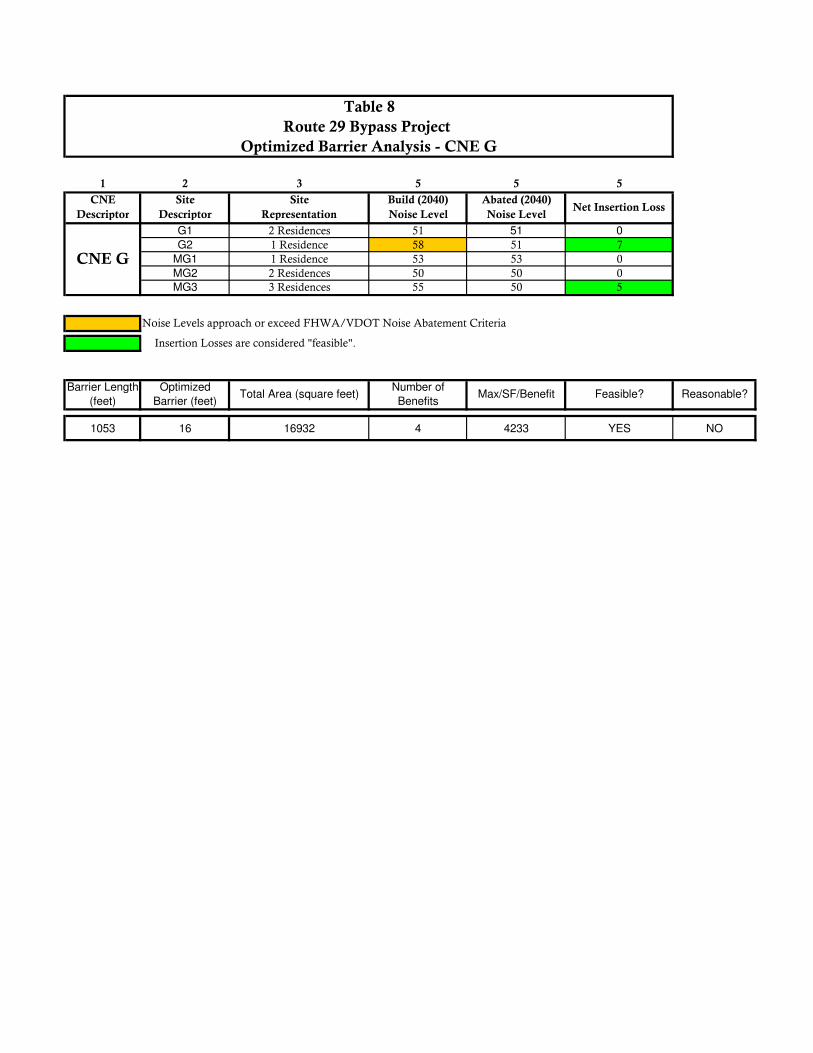
which exceeds VDOT’s allowable criteria. Considering all factors, the conceptual barrier for CNE F is feasible, but not reasonable per VDOT criteria. CNE G A post-and-panel sound barrier system was evaluated to mitigate predicted impacts within CNE G. As shown in Figure 6, a conceptual barrier was evaluated along the proposed Route 29 Bypass southbound edge-of-shoulder from Roslyn Ridge Road to Lambs Road. The evaluated barrier for CNE G totals 1,053 feet in length and achieves feasible (>5dB(A)) reductions at an average height of approximately 16 feet, as shown in Table 8. This barrier effectively benefits four residential units, thus its MaxSF/BR is 4,233, which exceeds VDOT’s allowable criteria. Considering all factors, the conceptual barrier for CNE G is feasible, but not reasonable per VDOT criteria. CNE H A post-and-panel sound barrier system was evaluated to mitigate predicted impacts within CNE H. The impacts within CNE H are associated with Jack Jouett Middle School; therefore the “grid” system has been used for the noise abatement evaluation, per VDOT guidance. As shown in Figure 6, a conceptual barrier was evaluated along the southbound shoulder or the proposed alignment. The evaluated barrier for CNE H totals 1,112 feet in length and achieves feasible (>5dB(A)) reductions at an average height of approximately 16 feet, as shown in Table 9. This barrier effectively benefits the school and eight grid units, thus its MaxSF/BR is 1,988, which exceeds VDOT’s allowable criteria. Considering all factors, the conceptual barrier for CNE H is feasible, but not reasonable per VDOT criteria. CNE J A post-and-panel sound barrier system was evaluated to mitigate predicted impacts within CNE J. As shown in Figure 7, a conceptual barrier was evaluated along the southbound edge-of-shoulder of the proposed alignment. The evaluated barrier for CNE J totals 2,162 feet in length and achieves feasible (>5dB(A)) reductions at an average height of approximately 16 feet, as shown in Table 10. This barrier effectively benefits three residential units, thus its MaxSF/BR is 11,593, which exceeds VDOT’s allowable criteria. Considering all factors, the conceptual barrier for CNE J is feasible, but not reasonable per VDOT criteria. CNE K A two-barrier post-and-panel sound barrier system was evaluated to mitigate predicted impacts within CNE K. The residences within CNE K have similar exposure to existing and future predicted sound levels. Therefore, CNE K was not divided into separate CNEs even though it is bisected by the proposed alignment. Two barriers were evaluated for CNE K; one on each side of the proposed project alignment. As shown in Figures 7 and 8, the conceptual barriers were evaluated along the northbound and southbound edge-of-shoulders. The southbound barrier for CNE K totals 1,630 feet in length and achieves feasible (>5dB(A)) reductions at an average height of approximately 20 feet, as shown in Table 11. This barrier effectively benefits six

Route 29 Bypass Project Preliminary Noise Analysis Albemarle County and the City of Charlottesville, VA
17
residential units, thus its MaxSF/BR is 5,488, which exceeds VDOT’s allowable criteria. Considering all factors, this conceptual barrier for CNE K is feasible, but not reasonable per VDOT criteria. The northbound barrier for CNE K is designed to protect the impacted residence represented by receptor site MK3. This conceptual barrier for CNE K totals 856 feet in length and does not achieve feasible (>5dB(A)) reductions up to 28 feet in height, as shown in Table 11. Considering all factors, this conceptual barrier for CNE K is not feasible, and will not be discussed further. CNE P A post-and-panel sound barrier system was evaluated to mitigate predicted impacts within CNE P. As shown in Figures 8 and 9, a conceptual barrier was evaluated along the Route 250 Bypass westbound lanes and transitions on to the off ramp edge-of-shoulder. The evaluated barrier for CNE P totals 1,755 feet in length and achieves feasible (>5dB(A)) reductions at an average height of approximately 12 feet, as shown in Table 12. This barrier effectively benefits eight residential units, thus its MaxSF/BR is 2,625, which exceeds VDOT’s allowable criteria. Considering all factors, the conceptual barrier for CNE P is feasible, but not reasonable per VDOT criteria. All of the evaluated noise barriers for this project are shown on Figures 3-9. These noise barriers or barrier systems have been evaluated in accordance with VDOT’s three-phased approach on noise abatement. A summary of the evaluated barriers for the project can be seen in Table 13. The number of benefited units, evaluated noise barrier length, average height, area and estimated costs are summarized in the table. None of the conceptual barriers are considered feasible and reasonable at this time. The conclusions found in this report regarding noise abatement are preliminary. The project corridor will be evaluated with final roadway geometry in the final design phase and final commitments on noise abatement will not be made until that time. VII. Construction Noise VDOT is also concerned with noise generated during the construction phase of the proposed project. The degree of noise impact will vary, as it is directly related to the number and types of equipment used and the proximity to the noise-sensitive land use areas within the project corridor. Based on a review of the project area, no considerable, long-term construction-related noise impacts are anticipated. Any noise impacts that do occur as a result of roadway construction measures are anticipated to be temporary in nature and will cease upon completion of the project construction phase. The following will be utilized to help minimize potential construction-related noise impacts. A detailed discussion of VDOT’s construction noise policy can be viewed in Section 107.16(b) 3 Noise, VDOT’s Road and Bridge Specifications (VDOT, 2007).

Route 29 Bypass Project Preliminary Noise Analysis Albemarle County and the City of Charlottesville, VA
18
The Contractor’s operations shall be performed so that exterior noise levels measured during a noise-sensitive activity shall not exceed 80 decibels. Such noise level measurements shall be taken at a point on the perimeter of the construction limit that is closest to the adjoining property on which a noise-sensitive activity is occurring. A noise-sensitive activity is any activity for which lowered noise levels are essential if the activity is to serve its intended purpose and not present an unreasonable public nuisance. Such activities include, but are not limited to, those associated with residences, hospitals, nursing homes, churches, schools, libraries, parks, and recreational areas.
VDOT may monitor construction-related noise. If construction noise levels exceed 80 decibels during noise sensitive activities, the Contractor shall take corrective action before proceeding with operations. The Contractor shall be responsible for costs associated with the abatement of construction noise and the delay of operations attributable to noncompliance with these requirements.
VDOT may prohibit or restrict to certain portions of the project any work that produces objectionable noise between 10 P.M. and 6 A.M. If other hours are established by local ordinance, the local ordinance shall govern.
Equipment shall in no way be altered so as to result in noise levels that are greater than those produced by the original equipment.
When feasible, the Contractor shall establish haul routes that direct his vehicles away from developed areas and ensure that noise from hauling operations is kept to a minimum.
These requirements shall not be applicable if the noise produced by sources other than the Contractor’s operation at the point of reception is greater than the noise from the Contractor’s operation at the same point.
VIII. Public Involvement/Local Officials Coordination FHWA and VDOT policies require that VDOT provide certain information to local officials within whose jurisdiction the highway project is located in order to minimize future traffic noise impacts of Type I projects on currently undeveloped lands. Type I projects involve highway improvements with noise analysis. This must include information on noise-compatible land-use planning, noise impact zones in undeveloped land in the highway project corridor and federal participation in Type II projects (noise abatement only). This section of the report provides that information, as well as information about VDOT’s noise abatement program. VDOT’s current noise policy outlines VDOT’s approach to communication with local officials and provides information and resources on highway noise and noise-compatible land-use planning. VDOT’s intention is to assist local officials in planning the uses of undeveloped land adjacent to highways to minimize the potential impacts of highway traffic noise.
Route 29 Bypass Project Preliminary Noise Analysis Albemarle County and the City of Charlottesville, VA
19
Entering the Quiet Zone is a brochure that provides general information and examples to elected officials, planners, developers, and the general public about the problem of traffic noise and effective responses to it. A link to this brochure on FHWA’s website is provided: http://www.fhwa.dot.gov/environment/noise/noise_compatible_planning/federal_approach/land_use/qz00.cfm A wide variety of administrative strategies may be used to minimize or eliminate potential highway noise impacts, thereby preventing the need or desire for costly noise abatement structures such as noise barriers in future years. There are five broad categories of such strategies:
■ Zoning, ■ Other legal restrictions (subdivision control, building codes, health codes), ■ Municipal ownership or control of the land, ■ Financial incentives for compatible development, and ■ Educational and advisory services.
The Audible Landscape: A Manual for Highway and Land Use is a well-written and comprehensive guide addressing these noise-compatible land-use planning strategies, with significant detailed information. This document is available through FHWA’s Website, at http://www.fhwa.dot.gov/environment/noise/noise_compatible_planning/federal_approach/audible_landscape/al00.cfm IX. Noise Contours Noise level contours are lines of equal noise exposure that typically parallel roadway alignments and are often times useful to local officials in undeveloped corridors. Highway traffic noise is considered a linear noise source and sound levels can drop considerably over distance. The degree that sound levels decrease can vary based on a number of different factors including objects that shield the roadway noise, terrain features and ground cover type (e.g., pavement, grass or snow). The use of noise level contours have become increasingly popular over the last several years, as they have been implemented in planning programs for undeveloped areas with roadway noise influence. Through conscious planning efforts and noise contour generation, municipal officials can restrict future development inside the noise impact zone (i.e., the area within the 66-dB(A) noise contour). The only area where the 66-dB(A) line is predicted is in CNE P. Figure 9, shows the approximate 66-dB(A) noise level contours for the Design Year (2040) build scenario, for CNE P, when considering the proposed project alternative and the Design Year (2040) traffic volumes, speeds and composition. Table 14 shows the approximate distance of the 66a-dB(A) contour line from the center line of the proposed conceptual design for CNE P. Also required under the revised 2011 FHWA and VDOT noise policies is information on the noise impact zones adjacent to project roadways in undeveloped lands. To determine these zones, noise levels are computed at various distances from the edge of the project roadways in each of the undeveloped areas of the project study area. Then, the distances from the edge of the roadway to the NAC sound levels are determined through interpolation. Distances vary in the project corridor due to changes in traffic volumes or terrain features. Any noise sensitive sites

Route 29 Bypass Project Preliminary Noise Analysis Albemarle County and the City of Charlottesville, VA
20
within the zones shown in Figures 3-9, should be considered noise impacted if no barrier is present to reduce sound levels. X. Conclusion In summary, the results of the noise analysis for the Route 29 Bypass Project indicate that Design Year Build (2040) noise levels exceed the NAC within nine of the evaluated CNEs for the project area. As identified in Tables 3A and 3B, by the sound level ranges listed in Column 7, Design Year Build (2040) noise levels are projected to approach or exceed the FHWA/VDOT NAC at approximately 56 residential land use areas and the lands associated with the Agnor Hurt Elementary and Jack Jouett Middle School and thus warrant noise abatement consideration. Noise abatement evaluations conclude that noise abatement is warranted, feasible but not reasonable for CNEs B, D, F, G, H, J, K and P as shown on Figures 3-9. The findings in this report are based on conceptual information. Firm commitments on noise abatement will not be made until the final design phase of the project.

TABLES

Land Use
Activity Category
Lands on which serenty and quiet are of extraordinary significance and serve
an important public need and where the preservation of those qualities is
essential if the area is to continue to serve its intended purpose.
B 67 (Exterior) Residential
Active sport areas, amphitheaters, auditoriums, campgrounds, cemeteries,
day care centers, hospitals, libraries, medical facilities, parks, picnic areas,
places of worship, playgrounds, public meeting rooms, public or non-profit
institutional structures, radio studios, recreation areas, Section 4(f) sites,
schools, television studios, trails and trail crossings.
Auditoriums, day care centers, hospitals, libraries, medical facilities, places
D 52 (Interior) of worship, public meeting rooms, public or nonprofit institutional structures,
radio stations, recording studios, schools and television studios.
Hotels, motels, offices, restaurants/bars and other developed lands,
properties or activities not included in A, B or C.
Agriculture, airports, bus yards, emergency services, industrial, logging,
maintenance facilities, manufacturing, mining, rail yards, retail facilities,
shipyards, utilities (water resources, water treatment, electrical) and
warehousing.
G --
Description of Land Use Activity CategoryLeq(h)
57 (Exterior)A
Undeveloped lands that are not permitted.
--F
Table 1
Hourly Weighted Sound Levels db(A) for Various Land Use
Activity Categories*
E 72 (Exterior)
C 67 (Exterior)

1 2 3 4 5 6 7
CNE Receptor Site Existing, Monitored TNM Modeled Difference Validates?
Designation Number Noise Level Noise Level (Mod.-Mon.)
A1 6 Residences 56.1 58.5 2.4 Yes
A2 3 Residences 48.6 50.5 1.9 Yes
A3 3 Residences 55.1 52.8 -2.3 Yes
CNE E E1 4 Residences 58.1 59.5 1.4 Yes
CNE L L2 Ste. Anne's Belfield School 61.6 63.6 2 Yes
CNE O O1 UVA Darden School 50.7 50.3 -0.4 Yes
CNE P P1 4 Residences 63.7 61.1 -2.6 Yes
Table 2
Route 29 Byapss Project - (2012) Noise Monitoring and Validation Results
CNE A
Site Representation

1 2 3 4 5 6 7
A1 6 Residences 56 63 66 64
A2 3 Residences 49 58 66 60
A3 3 Residences 55 51 61 56
MA1 6 Residences -- 55 65 57
MA2 4 Residences -- 49 59 51
MA3 2 Residences -- 57 66 60MA4 2 Residences -- 53 63 56
B1 3 Residences 51 51 61 58
MB1 4 Residences -- 51 61 63
MB2 2 Residences -- 51 61 58
MB3 5 Residences -- 51 61 56MB4 3 Residences -- 51 61 63
C1 Agnor Hurt Elementary 44 44 54 57
MC1 2 Residences -- 44 54 64
MC2 2 Residences -- 44 54 62
MC3 6 Residences (1st Story) -- 44 54 55
MC4 6 Residences (2nd Story) -- 44 54 57
MC5 6 Residences (3rd Story) -- 44 54 55
MC6 Agnor Hurt Elementary -- 44 54 56
MC7 Agnor Hurt Elementary -- 44 54 55
MC8 Agnor Hurt Elementary -- 44 54 55
MC9 Agnor Hurt Elementary -- 44 54 55
MC10 Agnor Hurt Elementary -- 44 54 54
MC11 Agnor Hurt Elementary -- 44 54 54
MC12 Agnor Hurt Elementary -- 44 54 54MC13 Agnor Hurt Elementary -- 44 54 53
D1 2 Residences 48 48 58 Acquired Property
MD1 4 Residences -- 48 58 55MD2 4 Residences -- 48 58 61
E1 4 Residences 58 54 64 55
ME1 5 Residences -- 55 65 57ME2 4 Residences -- 58 66 57
MF1 1 Residence -- 44 54 54
MF2 1 Residence -- 44 54 58MF3 1 Residence -- 44 54 50
G1 2 Residences 47 47 57 51
G2 1 Residence 44 44 54 58
MG1 1 Residence -- 44 54 53
MG2 2 Residences 47 57 50MG3 3 Residences 47 57 55
H1 Jack Jouett Middle School 43 43 53 60
MH1 Mary Greer Elementary School -- 43 53 51
MH2 1 Unit -- 43 53 59
MH3 1 Unit -- 43 53 62
MH4 1 Unit -- 43 53 63
MH5 1 Unit -- 43 53 62
MH6 1 Unit -- 43 53 55
MH7 1 Unit -- 43 53 57
MH8 1 Unit -- 43 53 58
MH9 1 Unit -- 43 53 58MH10 1 Unit -- 43 53 59
CNE I MI1 1 Residence -- 45 55 54
J1 3 Residences 45 45 55 Acquired Property
J2 3 Residences 44 44 54 58
MJ1 3 Residences -- 45 55 61
MJ2 1 Residence -- 45 55 Acquired PropertyMJ3 4 Residences -- 44 54 55
K1 3 Residences 45 45 55 56
MK1 3 Residences -- 45 55 52
MK2 3 Residences -- 45 55 56MK3 1 Residence -- 45 55 58
Noise Levels approach or exceed the "absolute" FHWA/VDOT Noise Abatement Criteria (67 dBA)
CNE C
Existing (2012) Worst-
case Noise Level
Noise
Abatement
Criteria
CNE J
CNE B
Build (2040) Noise
Level
CNE K
Table 3A
Route 29 Bypass Project
Sound Level Summary
CNE A
CNE
Descriptor
Site
DescriptorSite Representation
Existing (2012)
Monitored Noise Level
Noise Levels approach or exceed the "substantial increase" FHWA/VDOT Noise Abatement Criteria (+10 dBA over existing)
CNE D
CNE H
CNE F
CNE E
CNE G

1 2 3 4 5 6 7
L1 Ste. Anne's Belfield School 46 46 56 53
L2 Ste. Anne's Belfield School 62 70 66 64
ML1 Ste. Anne's Belfield School -- 64 66 57ML2 Ste. Anne's Belfield School -- 69 66 57
M1 6 Residences 48 52 62 55
MM1 12 Residences -- 53 63 55
MM2 University Village Condos 1st Story -- 53 63 60
MM3 University Village Condos 2nd Story -- 53 63 60
MM4 University Village Condos 3rd Story -- 53 63 61
MM5 University Village Condos 4th Story -- 53 63 61MM6 University Village Condos 5th Story -- 53 63 61
MN1 2 Residences -- 57 66 58
MN2 3 Residences -- 58 66 60
MN3 2 Residences -- 61 66 63
O1 U. of Virginia Darden 51 56 (31)* 52 Interior 62 (37)*
MO1 U. of Virginia Darden -- 55 (30)* 52 Interior 56 (31)*
MO2 U. of Virginia Darden -- 54 (29)* 52 Interior 56 (31)*
P1 3 Residences 64 65 66 60
MP1 2 Residences -- 52 62 55
MP2 3 Residences -- 59 66 57
MP3 3 Residences -- 66 66 62
MP4 3 Residences -- 63 66 62
MP5 3 Residences -- 69 66 67
MP6 4 Residences -- 65 66 65
MP7 5 Residences -- 58 66 58
MP8 2 Residences -- 63 66 63
MP9 3 Residences -- 57 66 57
MP10 2 Residences -- 57 66 58
Noise Levels approach or exceed the "absolute" FHWA/VDOT Noise Abatement Criteria (67 dBA)
Noise Levels approach or exceed the "substantial increase" FHWA/VDOT Noise Abatement Criteria (+10 dBA over existing)
CNE L
CNE M
CNE N
CNE O
CNE P
Sound Level Summary continued
CNE
Descriptor
* () Designates predicted interior sound levels for Category D land uses based on 25 dBA insertion losses for modern contstruction materials.
Noise
Abatement
Criteria
Build (2040) Noise
Level
Site
DescriptorSite Representation
Existing (2012)
Monitored Noise Level
Existing (2012) Worst-
case Noise Level
Route 29 Bypass Project
Table 3B

1 2 3 4 5 6
CNE Site Site Build (2040) Abated (2040)
Descriptor Descriptor Representation Noise Level Noise Level
B1 3 Residences 58 57 1
MB1 4 Residences 63 62 1
MB2 2 Residences 58 51 7
MB3 5 Residences 56 54 2
MB4 3 Residences 63 54 9
Noise Levels approach or exceed FHWA/VDOT Noise Abatement Criteria
3575 16 57512 5 11502 YES NO
Max/SF/Benefit Feasible? Reasonable?Barrier Length (feet)Optimized Barrier
(feet)Total Area (square feet) Number of Benefits
Insertion Losses are considered "feasible".
Net Insertion
Loss
Table 4
Route 29 Bypass Project
Optimized Barrier Analysis - CNE B
CNE B

1 2 3 5 5 5
CNE Site Site Build (2040) Abated (2040)
Descriptor Descriptor Representation Noise Level Noise Level
C1 Agnor Hurt Elementary 57 52 5
MC1 2 Residences 64 58 6
MC2 2 Residences 62 59 3
MC3 6 Residences (1st Story) 55 51 4
MC4 6 Residences (2nd Story) 57 54 3
MC5 6 Residences (3rd Story) 55 54 1
MC6 Agnor Hurt Elementary 56 52 4
MC7 Agnor Hurt Elementary 55 51 4
MC8 Agnor Hurt Elementary 55 51 4
MC9 Agnor Hurt Elementary 55 51 4
MC10 Agnor Hurt Elementary 54 50 4
MC11 Agnor Hurt Elementary 54 50 4
MC12 Agnor Hurt Elementary 54 50 4
MC13 Agnor Hurt Elementary 53 50 3
Noise Levels approach or exceed FHWA/VDOT Noise Abatement Criteria
1929 28 54713 3 18238 NO N/A
Max/SF/Benefit Feasible? Reasonable?Barrier Length
(feet)
Optimized Barrier
(feet)Total Area (square feet) Number of Benefits
Table 5
Route 29 Bypass Project
Optimized Barrier Analysis - CNE C
Insertion Losses are considered "feasible".
Net Insertion Loss
CNE C

1 2 3 5 5 5
CNE Site Site Build (2040) Abated (2040)
Descriptor Descriptor Representation Noise Level Noise Level
D1 Acquired Property N/A N/A N/A
MD1 4 Residences 55 51 4
MD2 4 Residences 61 52 9
Noise Levels approach or exceed FHWA/VDOT Noise Abatement Criteria
1178 12 14090 4 3523 YES NO
Reasonable?
Route 29 Bypass Project
Optimized Barrier Analysis - CNE D
Table 6
Barrier Length
(feet)
Optimized Barrier
(feet)Total Area (square feet)
Number of
BenefitsMax/SF/Benefit Feasible?
Insertion Losses are considered "feasible".
CNE D
Net Insertion Loss

1 2 3 5 5 5
CNE Site Site Build (2040) Abated (2040)
Descriptor Descriptor Representation Noise Level Noise Level
MF1 1 Residence 54 48 6
MF2 1 Residence 58 49 9
MF3 1 Residence 50 50 0
Noise Levels approach or exceed FHWA/VDOT Noise Abatement Criteria
1387 16 22324 2 11162 YES NO
Insertion Losses are considered "feasible".
Net Insertion Loss
Table 7
Route 29 Bypass
Optimized Barrier Analysis - CNE F
CNE F
Max/SF/Benefit Feasible? Reasonable?Barrier Length
(feet)
Optimized Barrier
(feet)Total Area (square feet)
Number of
Benefits
1 2 3 5 5 5
CNE Site Site Build (2040) Abated (2040)
Descriptor Descriptor Representation Noise Level Noise Level
G1 2 Residences 51 51 0
G2 1 Residence 58 51 7
MG1 1 Residence 53 53 0
MG2 2 Residences 50 50 0
MG3 3 Residences 55 50 5
Noise Levels approach or exceed FHWA/VDOT Noise Abatement Criteria
1053 16 16932 4 4233 YES NO
CNE G
Table 8
Route 29 Bypass Project
Optimized Barrier Analysis - CNE G
Net Insertion Loss
Insertion Losses are considered "feasible".
Barrier Length
(feet)
Optimized
Barrier (feet)Total Area (square feet)
Number of
BenefitsMax/SF/Benefit Feasible? Reasonable?
1 2 3 5 5 5
CNE Site Site Build (2040) Abated (2040)
Descriptor Descriptor Representation Noise Level Noise Level
H1 Jack Jouett Middle School 60 53 7
MH10 Mary Greer Elementary School 51 51 0
MH2 1 Unit 59 53 6
MH3 1 Unit 62 53 9
MH4 1 Unit 63 54 9
MH5 1 Unit 62 54 8
MH6 1 Unit 55 51 4
MH7 1 Unit 57 51 6
MH8 1 Unit 58 51 7
MH9 1 Unit 58 52 6
MH10 1 Unit 59 53 6
Noise Levels approach or exceed FHWA/VDOT Noise Abatement Criteria
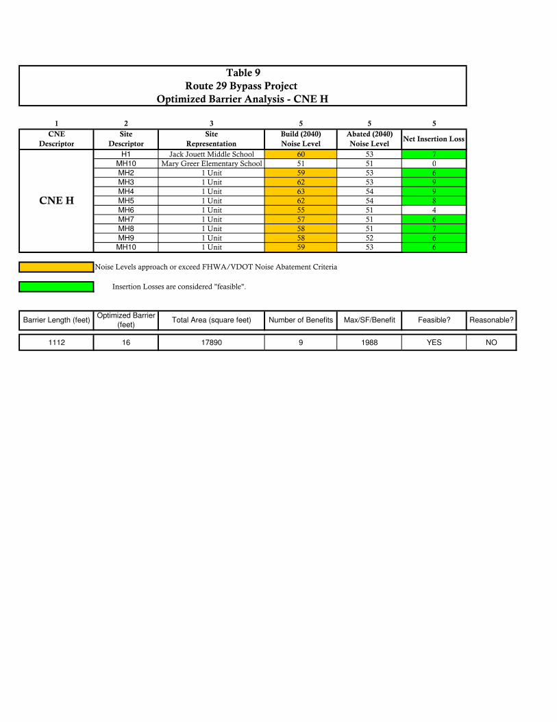
1112 16 17890 9 1988 YES NO
Table 9
Route 29 Bypass Project
Optimized Barrier Analysis - CNE H
Net Insertion Loss
Insertion Losses are considered "feasible".
CNE H
Barrier Length (feet)Optimized Barrier
(feet)Total Area (square feet) Number of Benefits Max/SF/Benefit Feasible? Reasonable?
1 2 3 5 5 5
CNE Site Site Build (2040) Abated (2040)
Descriptor Descriptor Representation Noise Level Noise Level
J1 Acquired Property N/A N/A N/A
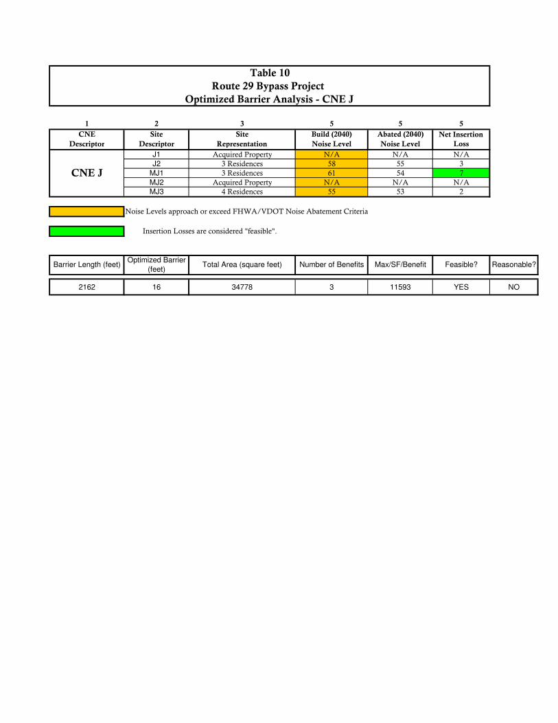
J2 3 Residences 58 55 3
MJ1 3 Residences 61 54 7
MJ2 Acquired Property N/A N/A N/A
MJ3 4 Residences 55 53 2
Noise Levels approach or exceed FHWA/VDOT Noise Abatement Criteria
2162 16 34778 3 11593 YES NO
Max/SF/Benefit Feasible? Reasonable?Barrier Length (feet)Optimized Barrier
(feet)Total Area (square feet) Number of Benefits
Insertion Losses are considered "feasible".
CNE J
Table 10
Route 29 Bypass Project
Optimized Barrier Analysis - CNE J
Net Insertion
Loss

1 2 3 5 5 5
CNE Site Site Build (2040) Abated (2040)
Descriptor Descriptor Representation Noise Level Noise Level
K1 3 Residences 56 51 5
MK1 3 Residences 52 50 2
MK2 3 Residences 56 51 5
1 2 3 5 5 5
CNE Site Site Build (2040) Abated (2040)
Descriptor Descriptor Representation Noise Level Noise Level
CNE K-2 MK3 1 Residence 58 57 1
Noise Levels approach or exceed FHWA/VDOT Noise Abatement Criteria
CNE K-1
1630 20 32927 6 5488 YES NO
CNE K-2
856 28 24262 0 N/A NO NO
Insertion Losses are considered "feasible".
CNE K-1
Table 11
Route 29 Bypass Project
Optimized Barrier Analysis - CNE K
Net Insertion
Loss
Barrier Length (feet)Optimized Barrier
(feet)Total Area (square feet) Number of Benefits Max/SF/Benefit Feasible? Reasonable?
Net Insertion
Loss
Max/SF/Benefit Feasible? Reasonable?Barrier Length (feet)Optimized Barrier
(feet)Total Area (square feet) Number of Benefits

1 2 3 5 5 5
CNE Site Site Build (2040) Abated (2040)
Descriptor Descriptor Representation Noise Level Noise Level
P1 3 Residences 60 59 1
MP1 2 Residences 55 55 0
MP2 3 Residences 57 56 1
MP3 3 Residences 62 61 1
MP4 3 Residences 62 60 2
MP5 3 Residences 67 56 11
MP6 4 Residences 65 64 1
MP7 5 Residences 58 53 5
MP8 2 Residences 63 60 3
MP9 3 Residences 57 56 1
MP10 2 Residences 58 56 2
Noise Levels approach or exceed FHWA/VDOT Noise Abatement Criteria
1755 12 21000 8 2625 YES NO
Insertion Losses are considered "feasible".
Table 12
Route 29 Bypass Project
Optimized Barrier Analysis - CNE P
Net Insertion
Loss
CNE P
Max/SF/Benefit Feasible? Reasonable?Barrier Length (feet)Optimized Barrier
(feet)Total Area (square feet) Number of Benefits
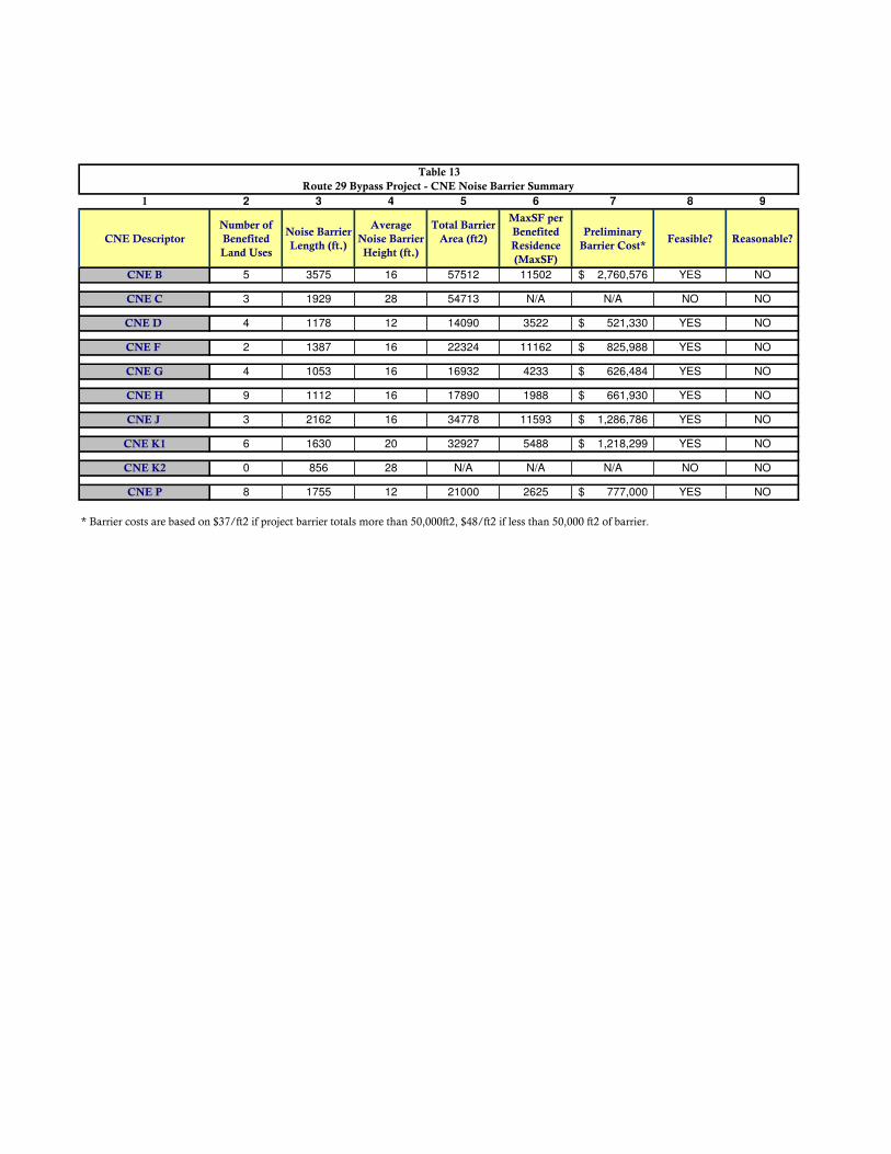
1 2 3 4 5 6 7 8 9
CNE Descriptor
Number of
Benefited
Land Uses
Noise Barrier
Length (ft.)
Average
Noise Barrier
Height (ft.)
Total Barrier
Area (ft2)
MaxSF per
Benefited
Residence
(MaxSF)
Preliminary
Barrier Cost*Feasible? Reasonable?
CNE B 5 3575 16 57512 11502 2,760,576$ YES NO
CNE C 3 1929 28 54713 N/A N/A NO NO
CNE D 4 1178 12 14090 3522 521,330$ YES NO
CNE F 2 1387 16 22324 11162 825,988$ YES NO
CNE G 4 1053 16 16932 4233 626,484$ YES NO
CNE H 9 1112 16 17890 1988 661,930$ YES NO
CNE J 3 2162 16 34778 11593 1,286,786$ YES NO
CNE K1 6 1630 20 32927 5488 1,218,299$ YES NO
CNE K2 0 856 28 N/A N/A N/A NO NO
CNE P 8 1755 12 21000 2625 777,000$ YES NO
* Barrier costs are based on $37/ft2 if project barrier totals more than 50,000ft2, $48/ft2 if less than 50,000 ft2 of barrier.
Table 13
Route 29 Bypass Project - CNE Noise Barrier Summary

CNE Distance (feet)
CNE P 145
TABLE 14
Route 29 Bypass Project
66 dB(A)
Distance from Centerline of Proposed Design to
CNE Specific Noise Contours
Design Year (2040) Noise Level Contours

FIGURES

§̈¦81
§̈¦64
§̈¦66
Virginia
WVWV
NCNC
MDMD
DEDE
PAPA
§̈¦95
§̈¦40
§̈¦70
§̈¦95
.´
A l b e m a r l eA l b e m a r l eC o u n t yC o u n t y
ST20
ST20
£¤250
£¤29
§̈¦64
Charlottesville Bypass ProjectState Project #0029-002-844, P101;
UPC 102419
Albemarle County andCity of Charlottesville, Virginia
Virginia Department of Transportation
´0 1,100 2,200 3,300 4,400 Feet
043
77
_h
b_
Ch
arlo
tte
svill
e_
Byp
ass
_cu
t_sh
ee
t_o
verv
iew
_JJ
W_
04
354
8/3
/20
12
1:1
5:4
4 P
M
Figure 2Figure 2

!? Monitoring / Modeling Receptor
!? Modeling Receptor
CNE Boundary§̈¦81
§̈¦64
§̈¦66
Virginia
WVWV
NCNC
MDMD
DEDE
PAPA
§̈¦95
§̈¦40
§̈¦70
§̈¦95
.´
£¤29
£¤250£¤250 £¤29 £¤29 ST20
A l b e m a r l eA l b e m a r l eC o u n t yC o u n t y
Charlottesville Bypass ProjectState Project #0029-002-844, P101;
UPC 102419
Albemarle County andCity of Charlottesville, Virginia
Virginia Department of Transportation
´0 200 400 600 800 Feet
0 48 96 144 192 Meters
043
54
_h
b_
Ch
arlo
tte
svill
e_
Byp
ass
_11
x17
_cu
t_sh
ee
ts_J
JW_
04
33
6 8
/3/2
01
2 1
1:5
7:1
9 A
M
Figure 3Figure 3

Evaluated Barrier
!? Modeling Receptor
CNE Boundary§̈¦81
§̈¦64
§̈¦66
Virginia
WVWV
NCNC
MDMD
DEDE
PAPA
§̈¦95
§̈¦40
§̈¦70
§̈¦95
.´
£¤29
£¤250£¤250 £¤29 £¤29 ST20
A l b e m a r l eA l b e m a r l eC o u n t yC o u n t y
Charlottesville Bypass ProjectState Project #0029-002-844, P101;
UPC 102419
Albemarle County andCity of Charlottesville, Virginia
Virginia Department of Transportation
´0 200 400 600 800 Feet
0 48 96 144 192 Meters
043
54
_h
b_
Ch
arlo
tte
svill
e_
Byp
ass
_11
x17
_cu
t_sh
ee
ts_J
JW_
04
33
6 8
/3/2
01
2 1
1:5
7:1
9 A
M
Figure 4Figure 4
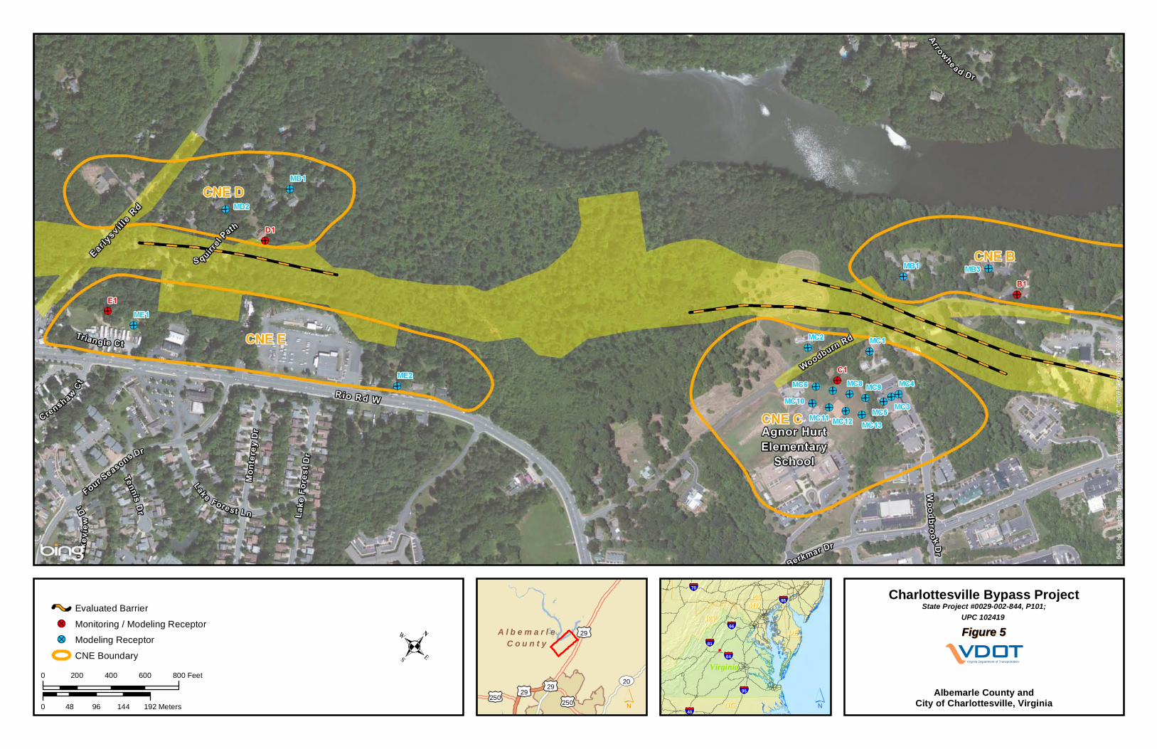
Evaluated Barrier
!? Monitoring / Modeling Receptor
!? Modeling Receptor
CNE Boundary§̈¦81
§̈¦64
§̈¦66
Virginia
WVWV
NCNC
MDMD
DEDE
PAPA
§̈¦95
§̈¦40
§̈¦70
§̈¦95
.´
£¤29
£¤250£¤250 £¤29 £¤29 ST20
A l b e m a r l eA l b e m a r l eC o u n t yC o u n t y
Charlottesville Bypass ProjectState Project #0029-002-844, P101;
UPC 102419
Albemarle County andCity of Charlottesville, Virginia
Virginia Department of Transportation
´0 200 400 600 800 Feet
0 48 96 144 192 Meters
043
54
_h
b_
Ch
arlo
tte
svill
e_
Byp
ass
_11
x17
_cu
t_sh
ee
ts_J
JW_
04
33
6 8
/3/2
01
2 1
1:5
7:1
9 A
M
Figure 5Figure 5
Evaluated Barrier
!? Monitoring / Modeling Receptor
!? Modeling Receptor
CNE Boundary§̈¦81
§̈¦64
§̈¦66
Virginia
WVWV
NCNC
MDMD
DEDE
PAPA
§̈¦95
§̈¦40
§̈¦70
§̈¦95
.´
£¤29
£¤250£¤250 £¤29 £¤29 ST20
A l b e m a r l eA l b e m a r l eC o u n t yC o u n t y
Charlottesville Bypass ProjectState Project #0029-002-844, P101;
UPC 102419
Albemarle County andCity of Charlottesville, Virginia
Virginia Department of Transportation
´0 200 400 600 800 Feet
0 48 96 144 192 Meters
043
54
_h
b_
Ch
arlo
tte
svill
e_
Byp
ass
_11
x17
_cu
t_sh
ee
ts_J
JW_
04
33
6 8
/3/2
01
2 1
1:5
7:1
9 A
M
Figure 6Figure 6
Evaluated Barrier
!? Monitoring / Modeling Receptor
!? Modeling Receptor
CNE Boundary§̈¦81
§̈¦64
§̈¦66
Virginia
WVWV
NCNC
MDMD
DEDE
PAPA
§̈¦95
§̈¦40
§̈¦70
§̈¦95
.´
£¤29
£¤250£¤250 £¤29 £¤29 ST20
A l b e m a r l eA l b e m a r l eC o u n t yC o u n t y
Charlottesville Bypass ProjectState Project #0029-002-844, P101;
UPC 102419
Albemarle County andCity of Charlottesville, Virginia
Virginia Department of Transportation
´0 200 400 600 800 Feet
0 48 96 144 192 Meters
043
54
_h
b_
Ch
arlo
tte
svill
e_
Byp
ass
_11
x17
_cu
t_sh
ee
ts_J
JW_
04
33
6 8
/3/2
01
2 1
1:5
7:1
9 A
M
Figure 7Figure 7

Evaluated Barrier
!? Monitoring / Modeling Receptor
!? Modeling Receptor
CNE Boundary§̈¦81
§̈¦64
§̈¦66
Virginia
WVWV
NCNC
MDMD
DEDE
PAPA
§̈¦95
§̈¦40
§̈¦70
§̈¦95
.´
£¤29
£¤250£¤250 £¤29 £¤29 ST20
A l b e m a r l eA l b e m a r l eC o u n t yC o u n t y
Charlottesville Bypass ProjectState Project #0029-002-844, P101;
UPC 102419
Albemarle County andCity of Charlottesville, Virginia
Virginia Department of Transportation
´0 200 400 600 800 Feet
0 48 96 144 192 Meters
043
54
_h
b_
Ch
arlo
tte
svill
e_
Byp
ass
_11
x17
_cu
t_sh
ee
ts_J
JW_
04
33
6 8
/3/2
01
2 1
1:5
7:1
9 A
M
Figure 8Figure 8
66dBA Noise Contour
Evaluated Barrier
!? Monitoring / Modeling Receptor
!? Modeling Receptor
CNE Boundary§̈¦81
§̈¦64
§̈¦66
Virginia
WVWV
NCNC
MDMD
DEDE
PAPA
§̈¦95
§̈¦40
§̈¦70
§̈¦95
.´
£¤29
£¤250£¤250 £¤29 £¤29 ST20
A l b e m a r l eA l b e m a r l eC o u n t yC o u n t y
Charlottesville Bypass ProjectState Project #0029-002-844, P101;
UPC 102419
Albemarle County andCity of Charlottesville, Virginia
Virginia Department of Transportation
´0 200 400 600 800 Feet
0 48 96 144 192 Meters
043
54
_h
b_
Ch
arlo
tte
svill
e_
Byp
ass
_11
x17
_cu
t_sh
ee
ts_J
JW_
04
33
6 8
/3/2
01
2 1
1:5
7:1
9 A
M
Figure 9Figure 9
Appendix A
NOISE METER CALIBRATION CERTIFICATES
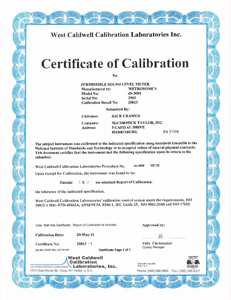


Appendix B
NOISE MONITORING DATA FORMS

Site # A1
Done By: TRH
Meter: 3908
Start End
Date 6/28/2012 6/28/2012
Time 5:15 PM 5:30 PM
Traffic NB/EB SB/WB
Cars 563 407
MT 7 10
HT 8 6
Buses Site Photo
Motorcycles
Total
Notes:
Approximately 200 feet from corridor.
Wind Speed (mph)Temp. (°F)
Humidity (%)
Charlottesville Bypass Project
McCormick Taylor, Inc
North
Description : Somer Chase Apartments - End unit

Site # A2
Done By: AJN
Meter: 3907
Start End
Date 6/28/2012 6/28/2012
Time 5:15 PM 5:30 PM
Traffic NB/EB SB/WB
Cars 563 407
MT 7 10
HT 8 6
Buses Site Photo
Motorcycles
Total
Notes: Mobile home located in Northwest corner
of Ridgewood Circle.
Approximately 300 feet from corridor.
Wind Speed (mph)Temp. (°F)
Humidity (%)
Charlottesville Bypass Project
McCormick Taylor, Inc
North
Description : Ridgewood Circle - Trailer Park

Site # A3
Done By: 3903
Meter: RVH
Start End
Date 6/28/2012 6/28/2012
Time 5:15 PM 5:30 PM
Traffic NB/EB SB/WB
Cars
MT
HT
Buses Site Photo
Motorcycles
Total
Notes:
Approximately 100 feet from corridor.
Wind Speed (mph)Temp. (°F)
Humidity (%)
Charlottesville Bypass Project
McCormick Taylor, Inc
North
Description : 2310 Ravenswood Court

Site # B1
Done By: AJN
Meter: 3907
Start End
Date 6/28/2012 6/28/2012
Time 2:50 PM 3:05 PM
Traffic NB/EB SB/WB
Cars
MT
HT
Buses Site Photo
Motorcycles
Total
Notes:
Approximately 400 feet from corridor.
Wind Speed (mph)Temp. (°F)
Humidity (%)
Charlottesville Bypass Project
McCormick Taylor, Inc
North
Description : 644 Woodburn Court

Site # C1
Done By: DAH
Meter: 3905
Start End
Date 6/28/2012 6/28/2012
Time 2:50 PM 3:05 PM
Traffic NB/EB SB/WB
Cars
MT
HT
Buses Site Photo
Motorcycles
Total
Notes:
Approximately 400 feet from corridor.
Wind Speed (mph)Temp. (°F)
Humidity (%)
Charlottesville Bypass Project
McCormick Taylor, Inc
North
Description : Agnor Hurt Elementary School

Site # D1
Done By: 3908
Meter: TRH
Start End
Date 6/28/2012 6/28/2012
Time 2:50 PM 3:05 PM
Traffic NB/EB SB/WB
Cars
MT
HT
Buses Site Photo
Motorcycles
Total
Notes:
Moped: 2:51; 2:53; 2:54
Approximately 100 feet from corridor.
Wind Speed (mph)Temp. (°F)
Humidity (%)
Charlottesville Bypass Project
McCormick Taylor, Inc
North
Description : 312 Squirrel Path
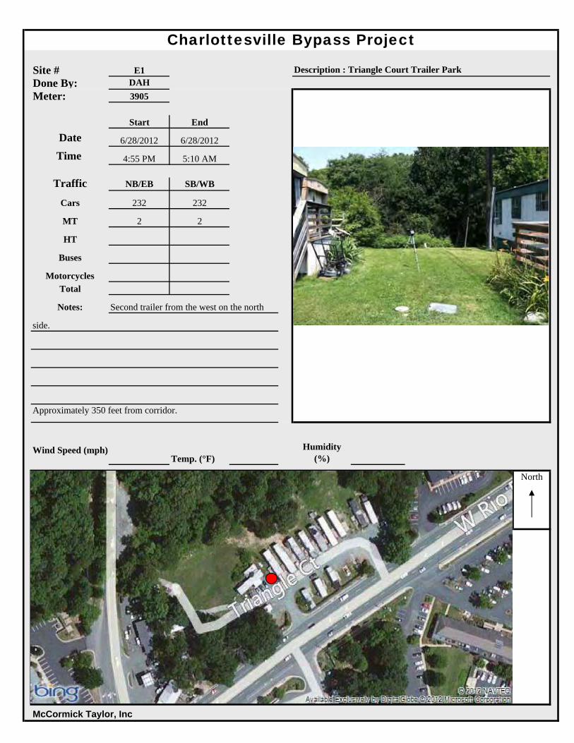
Site # E1
Done By: DAH
Meter: 3905
Start End
Date 6/28/2012 6/28/2012
Time 4:55 PM 5:10 AM
Traffic NB/EB SB/WB
Cars 232 232
MT 2 2
HT
Buses Site Photo
Motorcycles
Total
Notes: Second trailer from the west on the north
side.
Approximately 350 feet from corridor.
Wind Speed (mph)Temp. (°F)
Humidity (%)
Charlottesville Bypass Project
McCormick Taylor, Inc
North
Description : Triangle Court Trailer Park

Site # F1
Done By: RVH
Meter: 3903
Start End
Date 6/28/2012 6/28/2012
Time 2:50 PM 3:05 PM
Traffic NB/EB SB/WB
Cars
MT
HT
Buses Site Photo
Motorcycles
Total
Notes:
Approximately 300 feet from corridor.
Wind Speed (mph)Temp. (°F)
Humidity (%)
Charlottesville Bypass Project
McCormick Taylor, Inc
North
Description : 95 Rosslyn Forest Lane

Site # G1
Done By: AJN
Meter: 3907
Start End
Date 6/28/2012 6/28/2012
Time 3:55 PM 4:10 PM
Traffic NB/EB SB/WB
Cars
MT
HT
Buses Site Photo
Motorcycles
Total
Notes:
Approximately 400 feet from corridor.
Wind Speed (mph)Temp. (°F)
Humidity (%)
Charlottesville Bypass Project
McCormick Taylor, Inc
North
Description : 1995 Lambs Road

Site # H1
Done By: DAH
Meter: 3905
Start End
Date 6/28/2012 6/28/2012
Time 3:55 PM 4:10 PM
Traffic NB/EB SB/WB
Cars
MT
HT
Buses Site Photo
Motorcycles
Total
Notes: School located off of Lambs Lane.
Approximately 250 feet from corridor.
Wind Speed (mph)Temp. (°F)
Humidity (%)
Charlottesville Bypass Project
McCormick Taylor, Inc
North
Description : Jack Jouett Middle School

Site # J1
Done By: TRH
Meter: 3908
Start End
Date 6/28/2012 6/28/2012
Time 3:55 PM 4:10 PM
Traffic NB/EB SB/WB
Cars
MT
HT
Buses Site Photo
Motorcycles
Total
Notes:
Low Prop Plane: 4:11 PM
Approximately 100 feet from corridor.
Wind Speed (mph)Temp. (°F)
Humidity (%)
Charlottesville Bypass Project
McCormick Taylor, Inc
North
Description : 219 Montvue Drive

Site # J2
Done By: RVH
Meter: 3903
Start End
Date 6/28/2012 6/28/2012
Time 3:55 PM 4:10 PM
Traffic NB/EB SB/WB
Cars
MT
HT
Buses Site Photo
Motorcycles
Total
Notes:
Approximately 300 feet from corridor.
Wind Speed (mph)Temp. (°F)
Humidity (%)
Charlottesville Bypass Project
McCormick Taylor, Inc
North
Description : 2804 Magnolia Drive

Site # K1
Done By: DAH
Meter: 3903
Start End
Date 6/28/2012 6/28/2012
Time 7:55 PM 8:10 PM
Traffic NB/EB SB/WB
Cars
MT
HT
Buses Site Photo
Motorcycles
Total
Notes:
Plane: 8:10 PM
Approximately 400 feet from corridor.
Wind Speed (mph)Temp. (°F)
Humidity (%)
Charlottesville Bypass Project
McCormick Taylor, Inc
North
Description : 109 Falcon Drive

Site # L1
Done By: AJN
Meter: 3907
Start End
Date 6/28/2012 6/28/2012
Time 6:23 PM 6:38 PM
Traffic NB/EB SB/WB
Cars
MT
HT
Buses Site Photo
Motorcycles
Total
Notes:
Softball practice nearby, shouting adds ~1-2 dB(A)
Plane: 6:32 PM
Approximately 600 feet from corridor.
Wind Speed (mph)Temp. (°F)
Humidity (%)
Charlottesville Bypass Project
McCormick Taylor, Inc
North
Description : St. Anne's Belfield School

Site # L2
Done By: DAH
Meter: 3905
Start End
Date 6/28/2012 6/28/2012
Time 6:23 PM 6:38 PM
Traffic NB/EB SB/WB
Cars
MT
HT
Buses Site Photo
Motorcycles
Total
Notes:
Cars: 6:24, 6:26, 6:27, 6:32, 6:33, 6:38
Approximately 200 feet from corridor.
Wind Speed (mph)Temp. (°F)
Humidity (%)
Charlottesville Bypass Project
McCormick Taylor, Inc
North
Description : St. Anne's Belfield School

Site # M1
Done By: TRH
Meter: 3908
Start End
Date 6/28/2012 6/28/2012
Time 7:05 PM 7:20 PM
Traffic NB/EB SB/WB
Cars
MT
HT
Buses Site Photo
Motorcycles
Total
Notes:
Approximately 800 feet from corridor.
Wind Speed (mph)Temp. (°F)
Humidity (%)
Charlottesville Bypass Project
McCormick Taylor, Inc
North
Description : Harvest Drive - NW Apartment Unit

Site # N1
Done By: RVH
Meter: 3903
Start End
Date 6/28/2012 6/28/2012
Time 7:05 PM 7:20 PM
Traffic NB/EB SB/WB
Cars
MT
HT
Buses Site Photo
Motorcycles
Total
Notes:
Approximately 300 feet from corridor.
Wind Speed (mph)Temp. (°F)
Humidity (%)
Charlottesville Bypass Project
McCormick Taylor, Inc
North
Description : 7 Old Farm Drive

Site # O1
Done By: AJN
Meter: 3907
Start End
Date 6/28/2012 6/28/2012
Time 7:12 PM 7:15 PM
Traffic NB/EB SB/WB
Cars 189 432
MT 2 8
HT 4 5
Buses Site Photo
Motorcycles
Total
Notes:
Approximately 200 feet from corridor.
Wind Speed (mph)Temp. (°F)
Humidity (%)
Charlottesville Bypass Project
McCormick Taylor, Inc
North
Description : UVA Campus - Darden School Parking Garage

Site # P1
Done By: DAH
Meter: 3905
Start End
Date 6/28/2012 6/28/2012
Time 7:12 PM 7:27 PM
Traffic NB/EB SB/WB
Cars
MT
HT
Buses Site Photo
Motorcycles
Total
Notes:
Approximately 100 feet from corridor.
Wind Speed (mph)Temp. (°F)
Humidity (%)
Charlottesville Bypass Project
McCormick Taylor, Inc
North
Description : 322 Westminster Road
Appendix C
METROSONICS PRINTOUTS NOISE MONITORING DATA

A1*********************************************************************Filename...............3908Test Location.......... Employee Name.......... Employee Number........ Department............. Calibrator Type........ Calibrator Cal. Date... *********************************************************************
METROSONICS db-3080 V1.12 SERIAL # 3908REPORT PRINTED ON 06/29/12 at 13:22:57
User ID: ______________________________
LOGGING STARTED......06/28/12 at 17:06:40TOTAL LOGGING TIME...0 DAYS 00:16:55LOGGING STOPPED......06/28/12 at 17:23:35TOTAL INTERVALS......102INTERVAL LENGTH......00:00:10
AUTO STOP............NOCLOCK SYNCH..........YESRESPONSE RATE........SLOWFILTER...............A WT.
PRE-TEST CALIBRATION TIME....06/28/12 AT 13:59:41PRE-TEST CALIBRATION RANGE...38.9 TO 138.9 dBPOST-TEST CALIBRATION NOT DONECUTOFF USED FOR TIME HISTORY Lav...NONE
<<< SUMMARY REPORT FOR TEST NUMBER 4 OF 5 >>>
EXCHANGE RATE..........3dBCUTOFFS................ 80dB 90dBCEILING................115dBDOSE CRITERION LEVEL... 90dBDOSE CRITERION LENGTH.. 8 HOURS
Lav............ 56.1dBLav ( 80)...... 38.9dBLav ( 90)...... 38.9dBSEL............ 86.0dB
TWA............ 41.6dBTWA ( 80)...... 38.9dBTWA ( 90)...... 38.9dB
Lmax........... 70.0dB 06/28/12 at 17:13:07Lpk............UNDER RANGETIME OVER 115dB...00:00:00.00
Page 1

A1DOSE ( 80)........ 0.00%PROJ. DOSE ( 80).. 0.00%DOSE ( 90)........ 0.00%PROJ. DOSE ( 90).. 0.00%
<<< TIME HISTORY REPORT FOR TEST NUMBER 4 OF 5 >>>
TIME Lav Lmax Lpk L(10.0) L(99.9) dBA dBA dBC dBA dBA06/28/1217:06:40 56.4 60.0 UNDER 59.9 50.917:06:50 50.0 51.7 UNDER 51.9 48.917:07:00 52.7 55.1 UNDER 54.9 49.917:07:10 56.0 60.6 UNDER 59.9 52.917:07:20 56.4 59.9 UNDER 58.9 53.917:07:30 54.5 55.1 UNDER 55.9 53.917:07:40 54.5 56.1 UNDER 55.9 53.917:07:50 59.6 62.6 UNDER 62.9 55.917:08:00 57.6 60.9 UNDER 59.9 53.917:08:10 52.9 54.3 UNDER 54.9 50.917:08:20 57.3 61.4 UNDER 61.9 49.917:08:30 51.9 53.8 UNDER 53.9 49.917:08:40 56.0 61.4 UNDER 61.9 49.917:08:50 54.7 60.8 UNDER 59.9 47.917:09:00 46.7 47.9 UNDER 47.9 45.917:09:10 54.0 56.8 UNDER 56.9 48.917:09:20 56.4 58.9 UNDER 58.9 54.917:09:30 55.2 56.9 UNDER 56.9 53.917:09:40 55.3 57.2 UNDER 56.9 53.917:09:50 54.8 56.1 UNDER 55.9 53.917:10:00 55.2 55.8 UNDER 55.9 54.917:10:10 53.1 55.5 UNDER 55.9 48.917:10:20 49.0 54.6 UNDER 51.9 46.917:10:30 62.7 65.3 UNDER 65.9 54.917:10:40 55.7 62.2 UNDER 59.9 51.917:10:50 48.8 51.7 UNDER 50.9 46.917:11:00 58.7 62.2 UNDER 61.9 49.917:11:10 54.5 57.3 UNDER 55.9 53.917:11:20 57.4 60.5 UNDER 59.9 53.917:11:30 56.8 59.0 UNDER 58.9 55.917:11:40 57.5 59.7 UNDER 59.9 55.917:11:50 57.3 59.4 UNDER 59.9 54.917:12:00 55.6 57.4 UNDER 57.9 53.917:12:10 53.2 55.0 UNDER 54.9 52.917:12:20 55.1 58.6 UNDER 58.9 48.917:12:30 49.2 52.9 UNDER 51.9 47.917:12:40 59.7 65.1 UNDER 64.9 51.917:12:50 52.8 53.9 UNDER 53.9 51.917:13:00 63.8 70.0 UNDER 69.9 53.917:13:10 55.9 62.2 UNDER 59.9 50.917:13:20 57.0 59.5 UNDER 59.9 50.917:13:30 57.7 59.8 UNDER 59.9 55.917:13:40 54.0 55.4 UNDER 54.9 53.917:13:50 52.1 54.3 UNDER 54.9 49.917:14:00 50.7 54.3 UNDER 54.9 47.917:14:10 50.0 53.0 UNDER 52.9 48.917:14:20 53.2 57.0 UNDER 56.9 48.917:14:30 54.6 57.5 UNDER 57.9 49.917:14:40 57.4 63.4 UNDER 62.9 50.917:14:50 57.8 62.6 UNDER 61.9 51.917:15:00 57.7 61.8 UNDER 60.9 52.917:15:10 55.2 57.0 UNDER 56.9 53.9
Page 2

A117:15:20 54.8 56.4 UNDER 56.9 53.917:15:30 56.2 57.0 UNDER 56.9 55.917:15:40 55.8 56.6 UNDER 56.9 53.917:15:50 54.5 55.5 UNDER 55.9 52.917:16:00 53.5 56.5 UNDER 54.9 51.917:16:10 55.9 58.2 UNDER 57.9 52.917:16:20 54.2 56.9 UNDER 56.9 50.917:16:30 49.0 50.6 UNDER 49.9 47.917:16:40 54.8 61.0 UNDER 59.9 49.917:16:50 58.9 61.5 UNDER 61.9 53.917:17:00 54.7 56.6 UNDER 55.9 53.917:17:10 59.0 61.8 UNDER 61.9 55.917:17:20 55.6 56.3 UNDER 56.9 54.917:17:30 56.7 58.7 UNDER 58.9 54.917:17:40 55.7 56.7 UNDER 56.9 54.917:17:50 53.7 55.0 UNDER 54.9 52.917:18:00 51.3 52.8 UNDER 52.9 49.917:18:10 53.1 55.2 UNDER 54.9 51.917:18:20 52.4 54.3 UNDER 54.9 50.917:18:30 53.1 54.3 UNDER 54.9 50.917:18:40 57.7 66.3 UNDER 61.9 53.917:18:50 61.7 66.5 UNDER 66.9 55.917:19:00 55.2 56.6 UNDER 56.9 53.917:19:10 53.6 55.4 UNDER 54.9 52.917:19:20 56.6 58.9 UNDER 58.9 52.917:19:30 51.7 54.2 UNDER 53.9 50.917:19:40 54.7 57.4 UNDER 57.9 51.917:19:50 56.6 58.6 UNDER 57.9 54.917:20:00 56.7 59.6 UNDER 58.9 55.917:20:10 55.6 56.6 UNDER 56.9 53.917:20:20 54.1 55.7 UNDER 54.9 53.917:20:30 57.6 62.1 UNDER 61.9 53.917:20:40 54.7 58.6 UNDER 56.9 53.917:20:50 53.3 55.8 UNDER 55.9 51.917:21:00 59.3 63.2 UNDER 62.9 53.917:21:10 55.4 58.6 UNDER 56.9 54.917:21:20 54.6 56.2 UNDER 56.9 52.917:21:30 54.6 57.9 UNDER 55.9 53.917:21:40 54.4 57.9 UNDER 57.9 49.917:21:50 52.2 54.5 UNDER 54.9 49.917:22:00 48.7 51.6 UNDER 50.9 47.917:22:10 52.5 54.2 UNDER 53.9 47.917:22:20 52.8 55.8 UNDER 55.9 49.917:22:30 55.4 57.5 UNDER 57.9 54.917:22:40 56.8 60.7 UNDER 59.9 52.917:22:50 56.1 60.8 UNDER 60.9 51.917:23:00 54.4 56.0 UNDER 55.9 51.917:23:10 59.4 63.4 UNDER 62.9 54.917:23:20 59.3 62.1 UNDER 60.9 57.917:23:30 54.5 57.5 UNDER 57.9 51.9
Page 3
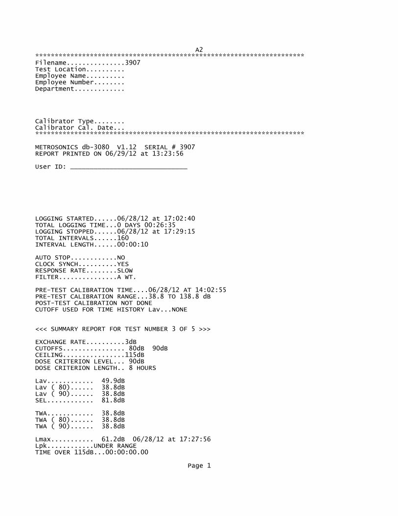
A2*********************************************************************Filename...............3907Test Location.......... Employee Name.......... Employee Number........ Department............. Calibrator Type........ Calibrator Cal. Date... *********************************************************************
METROSONICS db-3080 V1.12 SERIAL # 3907REPORT PRINTED ON 06/29/12 at 13:23:56
User ID: ______________________________
LOGGING STARTED......06/28/12 at 17:02:40TOTAL LOGGING TIME...0 DAYS 00:26:35LOGGING STOPPED......06/28/12 at 17:29:15TOTAL INTERVALS......160INTERVAL LENGTH......00:00:10
AUTO STOP............NOCLOCK SYNCH..........YESRESPONSE RATE........SLOWFILTER...............A WT.
PRE-TEST CALIBRATION TIME....06/28/12 AT 14:02:55PRE-TEST CALIBRATION RANGE...38.8 TO 138.8 dBPOST-TEST CALIBRATION NOT DONECUTOFF USED FOR TIME HISTORY Lav...NONE
<<< SUMMARY REPORT FOR TEST NUMBER 3 OF 5 >>>
EXCHANGE RATE..........3dBCUTOFFS................ 80dB 90dBCEILING................115dBDOSE CRITERION LEVEL... 90dBDOSE CRITERION LENGTH.. 8 HOURS
Lav............ 49.9dBLav ( 80)...... 38.8dBLav ( 90)...... 38.8dBSEL............ 81.8dB
TWA............ 38.8dBTWA ( 80)...... 38.8dBTWA ( 90)...... 38.8dB
Lmax........... 61.2dB 06/28/12 at 17:27:56Lpk............UNDER RANGETIME OVER 115dB...00:00:00.00
Page 1

A2DOSE ( 80)........ 0.00%PROJ. DOSE ( 80).. 0.00%DOSE ( 90)........ 0.00%PROJ. DOSE ( 90).. 0.00%
<<< TIME HISTORY REPORT FOR TEST NUMBER 3 OF 5 >>>
TIME Lav Lmax Lpk L(10.0) L(99.9) dBA dBA dBC dBA dBA06/28/1217:02:40 48.6 50.6 UNDER 50.8 46.817:02:50 49.2 50.5 UNDER 50.8 48.817:03:00 51.6 52.5 UNDER 52.8 50.817:03:10 50.6 51.0 UNDER 50.8 50.817:03:20 50.8 52.9 UNDER 52.8 49.817:03:30 50.7 52.5 UNDER 52.8 48.817:03:40 48.0 48.6 UNDER 48.8 47.817:03:50 50.8 53.8 UNDER 52.8 47.817:04:00 53.6 55.9 UNDER 55.8 51.817:04:10 51.8 54.9 UNDER 54.8 47.817:04:20 48.1 49.7 UNDER 49.8 47.817:04:30 48.4 50.1 UNDER 49.8 46.817:04:40 48.8 49.7 UNDER 49.8 47.817:04:50 49.4 49.7 UNDER 49.8 48.817:05:00 49.3 49.7 UNDER 49.8 48.817:05:10 49.6 49.8 UNDER 49.8 49.817:05:20 48.5 49.3 UNDER 49.8 47.817:05:30 47.1 47.5 UNDER 47.8 46.817:05:40 47.1 47.7 UNDER 47.8 46.817:05:50 46.9 47.7 UNDER 47.8 45.817:06:00 44.9 45.7 UNDER 45.8 44.817:06:10 44.1 44.9 UNDER 44.8 43.817:06:20 46.6 48.3 UNDER 48.8 44.817:06:30 48.6 48.9 UNDER 48.8 48.817:06:40 48.8 49.6 UNDER 49.8 48.817:06:50 50.2 50.5 UNDER 50.8 49.817:07:00 50.0 50.2 UNDER 50.8 49.817:07:10 49.9 51.3 UNDER 50.8 49.817:07:20 49.1 49.7 UNDER 49.8 48.817:07:30 49.4 50.6 UNDER 50.8 48.817:07:40 49.6 50.5 UNDER 50.8 48.817:07:50 48.4 49.7 UNDER 49.8 46.817:08:00 45.7 46.9 UNDER 46.8 45.817:08:10 46.3 46.9 UNDER 46.8 45.817:08:20 47.1 47.7 UNDER 47.8 46.817:08:30 47.9 48.9 UNDER 48.8 47.817:08:40 48.7 49.9 UNDER 49.8 48.817:08:50 50.4 51.1 UNDER 50.8 49.817:09:00 51.0 51.6 UNDER 51.8 49.817:09:10 49.1 49.7 UNDER 49.8 48.817:09:20 48.9 49.5 UNDER 49.8 48.817:09:30 48.5 49.3 UNDER 49.8 47.817:09:40 49.2 50.6 UNDER 50.8 48.817:09:50 47.8 50.0 UNDER 49.8 45.817:10:00 45.4 45.7 UNDER 45.8 45.817:10:10 46.6 48.0 UNDER 47.8 45.817:10:20 48.8 50.5 UNDER 49.8 47.817:10:30 49.9 51.3 UNDER 51.8 48.817:10:40 48.7 49.0 UNDER 48.8 48.817:10:50 49.0 49.7 UNDER 49.8 48.817:11:00 50.2 50.5 UNDER 50.8 49.817:11:10 49.4 50.1 UNDER 49.8 48.8
Page 2

A217:11:20 48.0 48.9 UNDER 48.8 47.817:11:30 47.5 47.8 UNDER 47.8 46.817:11:40 46.8 47.3 UNDER 47.8 46.817:11:50 47.1 47.6 UNDER 47.8 46.817:12:00 45.5 46.5 UNDER 46.8 44.817:12:10 47.7 48.9 UNDER 48.8 45.817:12:20 48.9 49.3 UNDER 49.8 48.817:12:30 48.8 49.0 UNDER 48.8 48.817:12:40 49.3 49.7 UNDER 49.8 48.817:12:50 49.2 49.4 UNDER 49.8 48.817:13:00 49.2 49.7 UNDER 49.8 48.817:13:10 48.8 49.3 UNDER 49.8 48.817:13:20 47.7 48.4 UNDER 48.8 47.817:13:30 47.4 47.8 UNDER 47.8 47.817:13:40 47.4 47.7 UNDER 47.8 46.817:13:50 46.9 47.3 UNDER 47.8 46.817:14:00 45.6 46.6 UNDER 46.8 44.817:14:10 46.2 47.3 UNDER 46.8 45.817:14:20 49.4 50.2 UNDER 50.8 47.817:14:30 49.7 50.0 UNDER 50.8 49.817:14:40 49.7 50.1 UNDER 49.8 49.817:14:50 50.5 50.8 UNDER 50.8 50.817:15:00 50.7 52.0 UNDER 51.8 50.817:15:10 52.9 57.3 UNDER 55.8 49.817:15:20 48.5 49.5 UNDER 49.8 48.817:15:30 48.4 48.9 UNDER 48.8 48.817:15:40 47.7 48.5 UNDER 48.8 46.817:15:50 46.5 47.3 UNDER 46.8 45.817:16:00 46.8 47.3 UNDER 47.8 46.817:16:10 47.1 48.1 UNDER 47.8 46.817:16:20 49.9 50.9 UNDER 50.8 48.817:16:30 50.8 51.8 UNDER 51.8 49.817:16:40 50.4 50.9 UNDER 50.8 49.817:16:50 49.2 50.0 UNDER 49.8 48.817:17:00 48.2 48.7 UNDER 48.8 47.817:17:10 48.6 49.2 UNDER 49.8 48.817:17:20 49.1 49.7 UNDER 49.8 48.817:17:30 47.8 49.6 UNDER 49.8 46.817:17:40 46.4 46.9 UNDER 46.8 45.817:17:50 45.0 45.4 UNDER 45.8 44.817:18:00 44.4 45.1 UNDER 44.8 43.817:18:10 45.9 48.1 UNDER 47.8 43.817:18:20 48.6 49.7 UNDER 49.8 48.817:18:30 50.6 51.6 UNDER 51.8 49.817:18:40 51.6 52.4 UNDER 52.8 51.817:18:50 54.2 55.4 UNDER 55.8 52.817:19:00 52.6 54.8 UNDER 54.8 50.817:19:10 49.8 50.8 UNDER 50.8 48.817:19:20 48.3 49.0 UNDER 48.8 47.817:19:30 48.0 48.5 UNDER 48.8 47.817:19:40 46.1 47.3 UNDER 46.8 44.817:19:50 44.6 45.7 UNDER 45.8 44.817:20:00 45.9 46.9 UNDER 46.8 44.817:20:10 47.2 47.7 UNDER 47.8 46.817:20:20 48.4 49.5 UNDER 49.8 47.817:20:30 49.7 50.0 UNDER 49.8 49.817:20:40 49.8 50.1 UNDER 50.8 49.817:20:50 50.0 50.5 UNDER 50.8 49.817:21:00 49.3 50.2 UNDER 50.8 48.817:21:10 48.1 48.4 UNDER 48.8 47.817:21:20 48.1 48.5 UNDER 48.8 47.817:21:30 48.2 49.3 UNDER 48.8 47.817:21:40 46.8 47.7 UNDER 47.8 44.8
Page 3

A217:21:50 45.0 46.1 UNDER 46.8 44.817:22:00 46.3 46.9 UNDER 46.8 45.817:22:10 46.5 48.9 UNDER 47.8 45.817:22:20 50.0 51.1 UNDER 50.8 48.817:22:30 51.4 52.9 UNDER 52.8 50.817:22:40 55.2 58.5 UNDER 57.8 52.817:22:50 54.6 57.6 UNDER 56.8 52.817:23:00 52.7 54.5 UNDER 54.8 50.817:23:10 50.9 52.0 UNDER 51.8 49.817:23:20 49.5 50.8 UNDER 50.8 48.817:23:30 47.7 50.2 UNDER 49.8 46.817:23:40 46.5 48.0 UNDER 47.8 45.817:23:50 45.8 47.0 UNDER 46.8 44.817:24:00 46.6 47.6 UNDER 47.8 45.817:24:10 47.9 48.7 UNDER 48.8 47.817:24:20 48.4 48.9 UNDER 48.8 48.817:24:30 49.3 50.5 UNDER 50.8 48.817:24:40 49.9 51.0 UNDER 50.8 48.817:24:50 53.9 56.1 UNDER 55.8 50.817:25:00 52.1 54.1 UNDER 53.8 49.817:25:10 49.1 49.7 UNDER 49.8 48.817:25:20 49.7 50.3 UNDER 50.8 48.817:25:30 55.7 58.3 UNDER 57.8 50.817:25:40 50.6 54.0 UNDER 53.8 45.817:25:50 46.5 48.3 UNDER 47.8 45.817:26:00 48.7 49.7 UNDER 49.8 47.817:26:10 50.3 51.2 UNDER 50.8 49.817:26:20 51.3 52.1 UNDER 51.8 50.817:26:30 50.7 51.3 UNDER 51.8 50.817:26:40 51.2 51.6 UNDER 51.8 50.817:26:50 50.6 51.1 UNDER 50.8 50.817:27:00 50.3 50.7 UNDER 50.8 50.817:27:10 52.4 54.9 UNDER 54.8 49.817:27:20 49.7 50.8 UNDER 50.8 48.817:27:30 50.2 51.4 UNDER 50.8 49.817:27:40 56.5 60.7 UNDER 59.8 49.817:27:50 58.0 61.2 UNDER 59.8 55.817:28:00 56.2 60.5 UNDER 58.8 50.817:28:10 50.6 51.4 UNDER 51.8 49.817:28:20 51.6 52.5 UNDER 52.8 51.817:28:30 51.4 52.1 UNDER 51.8 50.817:28:40 51.0 51.5 UNDER 51.8 50.817:28:50 50.7 52.6 UNDER 52.8 48.817:29:00 48.5 50.0 UNDER 49.8 48.817:29:10 49.7 54.1 UNDER 51.8 48.8
Page 4

A3*********************************************************************Filename...............3903Test Location.......... Employee Name.......... Employee Number........ Department............. Calibrator Type........ Calibrator Cal. Date... *********************************************************************
METROSONICS db-3080 V1.12 SERIAL # 3903REPORT PRINTED ON 06/29/12 at 13:26:55
User ID: ______________________________
LOGGING STARTED......06/28/12 at 16:55:30TOTAL LOGGING TIME...0 DAYS 00:27:52LOGGING STOPPED......06/28/12 at 17:23:22TOTAL INTERVALS......168INTERVAL LENGTH......00:00:10
AUTO STOP............NOCLOCK SYNCH..........YESRESPONSE RATE........SLOWFILTER...............A WT.
PRE-TEST CALIBRATION TIME....06/28/12 AT 13:58:19PRE-TEST CALIBRATION RANGE...39.5 TO 139.5 dBPOST-TEST CALIBRATION NOT DONECUTOFF USED FOR TIME HISTORY Lav...NONE
<<< SUMMARY REPORT FOR TEST NUMBER 3 OF 5 >>>
EXCHANGE RATE..........3dBCUTOFFS................ 80dB 90dBCEILING................115dBDOSE CRITERION LEVEL... 90dBDOSE CRITERION LENGTH.. 8 HOURS
Lav............ 55.3dBLav ( 80)...... 39.5dBLav ( 90)...... 39.5dBSEL............ 87.4dB
TWA............ 42.9dBTWA ( 80)...... 39.5dBTWA ( 90)...... 39.5dB
Lmax........... 64.0dB 06/28/12 at 16:58:11Lpk............UNDER RANGETIME OVER 115dB...00:00:00.00
Page 1

A3DOSE ( 80)........ 0.00%PROJ. DOSE ( 80).. 0.00%DOSE ( 90)........ 0.00%PROJ. DOSE ( 90).. 0.00%
<<< TIME HISTORY REPORT FOR TEST NUMBER 3 OF 5 >>>
TIME Lav Lmax Lpk L(10.0) L(99.9) dBA dBA dBC dBA dBA06/28/1216:55:30 53.9 54.4 UNDER 54.5 52.516:55:40 53.9 54.4 UNDER 54.5 53.516:55:50 54.2 54.8 UNDER 54.5 53.516:56:00 56.2 61.6 UNDER 58.5 54.516:56:10 57.1 61.4 UNDER 58.5 55.516:56:20 55.9 56.9 UNDER 56.5 55.516:56:30 55.7 56.8 UNDER 56.5 55.516:56:40 56.7 57.7 UNDER 57.5 55.516:56:50 56.1 57.6 UNDER 56.5 54.516:57:00 54.6 56.4 UNDER 55.5 53.516:57:10 53.8 54.3 UNDER 54.5 53.516:57:20 54.5 55.1 UNDER 54.5 53.516:57:30 55.1 55.3 UNDER 55.5 54.516:57:40 55.2 55.5 UNDER 55.5 54.516:57:50 57.1 58.4 UNDER 58.5 55.516:58:00 59.5 61.6 UNDER 60.5 57.516:58:10 59.9 64.0 UNDER 62.5 57.516:58:20 59.0 62.3 UNDER 61.5 56.516:58:30 55.2 56.0 UNDER 55.5 54.516:58:40 58.0 59.6 UNDER 59.5 55.516:58:50 55.5 56.8 UNDER 56.5 54.516:59:00 54.6 55.2 UNDER 55.5 53.516:59:10 53.9 54.4 UNDER 54.5 53.516:59:20 54.7 55.1 UNDER 54.5 54.516:59:30 54.9 55.5 UNDER 55.5 54.516:59:40 56.8 58.4 UNDER 58.5 55.516:59:50 55.7 56.4 UNDER 56.5 55.517:00:00 55.2 55.7 UNDER 55.5 54.517:00:10 55.2 55.6 UNDER 55.5 55.517:00:20 55.1 55.2 UNDER 55.5 54.517:00:30 55.3 55.6 UNDER 55.5 54.517:00:40 55.6 56.0 UNDER 56.5 55.517:00:50 54.7 55.5 UNDER 55.5 54.517:01:00 53.8 54.5 UNDER 54.5 53.517:01:10 55.2 57.2 UNDER 56.5 54.517:01:20 56.7 58.4 UNDER 58.5 55.517:01:30 55.1 55.6 UNDER 55.5 54.517:01:40 54.1 54.4 UNDER 54.5 53.517:01:50 54.4 54.8 UNDER 54.5 54.517:02:00 54.7 55.6 UNDER 55.5 53.517:02:10 53.3 54.0 UNDER 54.5 52.517:02:20 54.0 54.5 UNDER 54.5 53.517:02:30 55.4 55.6 UNDER 55.5 54.517:02:40 55.9 56.4 UNDER 56.5 55.517:02:50 55.0 56.4 UNDER 56.5 54.517:03:00 53.8 54.8 UNDER 54.5 53.517:03:10 54.2 54.8 UNDER 54.5 53.517:03:20 54.2 54.4 UNDER 54.5 54.517:03:30 53.9 54.4 UNDER 54.5 53.517:03:40 53.6 53.9 UNDER 53.5 53.517:03:50 54.4 54.8 UNDER 54.5 53.517:04:00 54.7 54.8 UNDER 54.5 54.5
Page 2

A317:04:10 55.1 55.6 UNDER 55.5 54.517:04:20 56.7 57.6 UNDER 57.5 55.517:04:30 57.0 57.8 UNDER 57.5 55.517:04:40 55.8 56.3 UNDER 56.5 55.517:04:50 55.2 56.0 UNDER 56.5 54.517:05:00 53.8 54.4 UNDER 54.5 53.517:05:10 54.0 54.4 UNDER 54.5 53.517:05:20 54.3 54.8 UNDER 54.5 53.517:05:30 54.5 54.8 UNDER 54.5 54.517:05:40 55.6 59.7 UNDER 58.5 54.517:05:50 54.9 55.6 UNDER 55.5 54.517:06:00 54.8 56.0 UNDER 55.5 53.517:06:10 53.6 54.7 UNDER 54.5 53.517:06:20 56.5 57.2 UNDER 57.5 54.517:06:30 57.2 58.3 UNDER 58.5 56.517:06:40 55.2 57.0 UNDER 56.5 54.517:06:50 54.7 55.2 UNDER 55.5 54.517:07:00 54.1 54.6 UNDER 54.5 53.517:07:10 54.3 54.7 UNDER 54.5 54.517:07:20 54.1 54.4 UNDER 54.5 54.517:07:30 54.0 54.4 UNDER 54.5 53.517:07:40 53.8 54.0 UNDER 54.5 53.517:07:50 55.2 57.6 UNDER 57.5 53.517:08:00 55.6 56.8 UNDER 56.5 55.517:08:10 54.8 55.9 UNDER 55.5 54.517:08:20 54.8 55.6 UNDER 55.5 54.517:08:30 56.0 56.8 UNDER 56.5 55.517:08:40 55.7 56.8 UNDER 56.5 54.517:08:50 54.2 54.8 UNDER 54.5 53.517:09:00 53.9 54.8 UNDER 54.5 53.517:09:10 54.5 55.4 UNDER 55.5 53.517:09:20 54.3 55.2 UNDER 54.5 53.517:09:30 54.2 55.2 UNDER 54.5 53.517:09:40 54.6 56.0 UNDER 55.5 53.517:09:50 55.5 56.4 UNDER 56.5 54.517:10:00 55.6 58.4 UNDER 56.5 54.517:10:10 54.5 55.2 UNDER 55.5 53.517:10:20 54.9 55.6 UNDER 55.5 54.517:10:30 56.7 60.4 UNDER 58.5 55.517:10:40 55.7 56.9 UNDER 56.5 55.517:10:50 54.7 55.4 UNDER 55.5 54.517:11:00 54.5 54.8 UNDER 54.5 54.517:11:10 54.1 54.4 UNDER 54.5 54.517:11:20 54.3 54.5 UNDER 54.5 53.517:11:30 53.9 54.0 UNDER 54.5 53.517:11:40 53.8 54.0 UNDER 54.5 53.517:11:50 54.3 54.8 UNDER 54.5 54.517:12:00 55.6 56.4 UNDER 56.5 54.517:12:10 55.4 55.6 UNDER 55.5 54.517:12:20 55.9 56.5 UNDER 56.5 55.517:12:30 56.1 56.7 UNDER 56.5 55.517:12:40 55.4 56.7 UNDER 56.5 54.517:12:50 54.1 54.4 UNDER 54.5 54.517:13:00 54.4 54.8 UNDER 54.5 54.517:13:10 54.3 54.5 UNDER 54.5 54.517:13:20 54.8 55.2 UNDER 55.5 54.517:13:30 54.8 55.2 UNDER 55.5 54.517:13:40 55.6 56.4 UNDER 56.5 54.517:13:50 57.0 58.0 UNDER 57.5 56.517:14:00 55.4 56.3 UNDER 56.5 55.517:14:10 55.0 55.2 UNDER 55.5 54.517:14:20 54.9 55.2 UNDER 55.5 54.517:14:30 56.8 58.8 UNDER 58.5 55.5
Page 3

A317:14:40 55.4 56.4 UNDER 55.5 54.517:14:50 56.1 57.2 UNDER 57.5 55.517:15:00 55.9 57.2 UNDER 57.5 54.517:15:10 54.7 56.0 UNDER 55.5 54.517:15:20 55.0 56.4 UNDER 56.5 54.517:15:30 55.0 56.1 UNDER 56.5 53.517:15:40 54.6 57.6 UNDER 55.5 54.517:15:50 55.6 56.8 UNDER 56.5 55.517:16:00 55.3 55.6 UNDER 55.5 55.517:16:10 56.0 57.2 UNDER 56.5 55.517:16:20 55.9 57.2 UNDER 56.5 55.517:16:30 55.6 56.3 UNDER 56.5 54.517:16:40 54.0 54.8 UNDER 54.5 53.517:16:50 53.7 54.0 UNDER 53.5 53.517:17:00 54.5 54.8 UNDER 54.5 54.517:17:10 54.9 55.2 UNDER 55.5 54.517:17:20 54.7 54.8 UNDER 54.5 54.517:17:30 54.3 54.8 UNDER 54.5 54.517:17:40 54.9 55.2 UNDER 55.5 54.517:17:50 55.0 55.2 UNDER 55.5 54.517:18:00 55.7 56.0 UNDER 56.5 55.517:18:10 55.0 55.6 UNDER 55.5 54.517:18:20 55.5 56.0 UNDER 55.5 55.517:18:30 55.0 55.6 UNDER 55.5 54.517:18:40 54.1 54.4 UNDER 54.5 53.517:18:50 54.0 54.4 UNDER 54.5 53.517:19:00 54.1 54.4 UNDER 54.5 53.517:19:10 54.1 54.4 UNDER 54.5 54.517:19:20 53.8 54.4 UNDER 54.5 53.517:19:30 54.4 55.6 UNDER 55.5 53.517:19:40 55.4 56.0 UNDER 55.5 54.517:19:50 57.0 58.4 UNDER 58.5 55.517:20:00 56.8 58.8 UNDER 58.5 54.517:20:10 55.7 56.7 UNDER 56.5 55.517:20:20 56.9 57.6 UNDER 57.5 55.517:20:30 55.7 57.2 UNDER 57.5 54.517:20:40 54.4 54.8 UNDER 54.5 53.517:20:50 54.3 54.8 UNDER 54.5 53.517:21:00 54.7 56.0 UNDER 55.5 53.517:21:10 53.7 54.8 UNDER 54.5 53.517:21:20 53.2 54.0 UNDER 54.5 52.517:21:30 53.8 54.0 UNDER 54.5 53.517:21:40 53.9 54.8 UNDER 54.5 53.517:21:50 54.9 55.3 UNDER 55.5 54.517:22:00 54.9 56.3 UNDER 55.5 54.517:22:10 59.3 63.6 UNDER 62.5 56.517:22:20 57.1 59.2 UNDER 58.5 54.517:22:30 56.0 58.0 UNDER 57.5 52.517:22:40 53.8 58.0 UNDER 55.5 52.517:22:50 52.4 53.2 UNDER 52.5 51.517:23:00 53.0 53.9 UNDER 53.5 52.517:23:10 52.2 52.8 UNDER 52.5 51.517:23:20 52.2 52.4 UNDER 52.5 52.5
Page 4

B1*********************************************************************Filename...............3907Test Location.......... Employee Name.......... Employee Number........ Department............. Calibrator Type........ Calibrator Cal. Date... *********************************************************************
METROSONICS db-3080 V1.12 SERIAL # 3907REPORT PRINTED ON 06/29/12 at 13:28:14
User ID: ______________________________
LOGGING STARTED......06/28/12 at 14:44:10TOTAL LOGGING TIME...0 DAYS 00:15:33LOGGING STOPPED......06/28/12 at 14:59:43TOTAL INTERVALS......94INTERVAL LENGTH......00:00:10
AUTO STOP............NOCLOCK SYNCH..........YESRESPONSE RATE........SLOWFILTER...............A WT.
PRE-TEST CALIBRATION TIME....06/28/12 AT 14:02:55PRE-TEST CALIBRATION RANGE...38.8 TO 138.8 dBPOST-TEST CALIBRATION NOT DONECUTOFF USED FOR TIME HISTORY Lav...NONE
<<< SUMMARY REPORT FOR TEST NUMBER 1 OF 5 >>>
EXCHANGE RATE..........3dBCUTOFFS................ 80dB 90dBCEILING................115dBDOSE CRITERION LEVEL... 90dBDOSE CRITERION LENGTH.. 8 HOURS
Lav............ 51.0dBLav ( 80)...... 38.8dBLav ( 90)...... 38.8dBSEL............ 80.6dB
TWA............ 38.8dBTWA ( 80)...... 38.8dBTWA ( 90)...... 38.8dB
Lmax........... 67.3dB 06/28/12 at 14:47:18Lpk............UNDER RANGETIME OVER 115dB...00:00:00.00
Page 1

B1DOSE ( 80)........ 0.00%PROJ. DOSE ( 80).. 0.00%DOSE ( 90)........ 0.00%PROJ. DOSE ( 90).. 0.00%
<<< TIME HISTORY REPORT FOR TEST NUMBER 1 OF 5 >>>
TIME Lav Lmax Lpk L(10.0) L(99.9) dBA dBA dBC dBA dBA06/28/1214:44:10 42.9 43.7 UNDER 43.8 42.814:44:20 43.7 45.2 UNDER 44.8 42.814:44:30 43.0 44.5 UNDER 43.8 42.814:44:40 43.7 46.4 UNDER 44.8 42.814:44:50 44.5 47.1 UNDER 46.8 42.814:45:00 43.0 45.0 UNDER 44.8 42.814:45:10 44.5 48.9 UNDER 46.8 42.814:45:20 42.7 44.9 UNDER 44.8 41.814:45:30 44.8 46.9 UNDER 46.8 42.814:45:40 49.5 55.3 UNDER 52.8 45.814:45:50 54.2 57.6 UNDER 57.8 45.814:46:00 44.0 45.7 UNDER 45.8 42.814:46:10 45.4 48.5 UNDER 48.8 43.814:46:20 45.2 48.1 UNDER 47.8 42.814:46:30 41.9 42.5 UNDER 42.8 41.814:46:40 42.4 42.9 UNDER 42.8 42.814:46:50 46.4 50.5 UNDER 49.8 42.814:47:00 55.7 61.3 UNDER 60.8 50.814:47:10 65.2 67.3 UNDER 66.8 61.814:47:20 59.0 65.3 UNDER 63.8 51.814:47:30 47.9 51.7 UNDER 50.8 44.814:47:40 42.4 45.3 UNDER 43.8 41.814:47:50 42.1 43.6 UNDER 42.8 41.814:48:00 41.0 41.8 UNDER 41.8 40.814:48:10 41.5 42.6 UNDER 42.8 40.814:48:20 44.2 44.9 UNDER 44.8 42.814:48:30 44.7 46.3 UNDER 45.8 43.814:48:40 43.1 45.8 UNDER 45.8 40.814:48:50 41.2 42.5 UNDER 41.8 40.814:49:00 41.4 43.1 UNDER 42.8 40.814:49:10 45.5 48.8 UNDER 48.8 40.814:49:20 56.0 62.5 UNDER 61.8 46.814:49:30 50.3 58.5 UNDER 55.8 42.814:49:40 42.6 43.3 UNDER 43.8 42.814:49:50 43.6 44.6 UNDER 44.8 42.814:50:00 42.5 44.5 UNDER 43.8 40.814:50:10 42.0 43.3 UNDER 42.8 41.814:50:20 41.0 41.7 UNDER 41.8 40.814:50:30 41.8 42.5 UNDER 42.8 40.814:50:40 51.5 58.1 UNDER 56.8 41.814:50:50 55.5 60.6 UNDER 60.8 46.814:51:00 43.8 46.1 UNDER 45.8 42.814:51:10 43.8 47.5 UNDER 46.8 42.814:51:20 50.3 56.0 UNDER 53.8 44.814:51:30 60.8 63.5 UNDER 62.8 56.814:51:40 56.2 62.7 UNDER 61.8 47.814:51:50 47.8 52.5 UNDER 50.8 43.814:52:00 42.6 43.3 UNDER 43.8 40.814:52:10 40.7 41.3 UNDER 41.8 40.814:52:20 40.5 41.2 UNDER 40.8 40.814:52:30 41.6 47.2 UNDER 44.8 39.814:52:40 40.7 42.6 UNDER 42.8 40.8
Page 2

B114:52:50 41.1 44.0 UNDER 43.8 40.814:53:00 47.9 52.1 UNDER 51.8 43.814:53:10 59.6 64.1 UNDER 63.8 51.814:53:20 45.1 51.3 UNDER 48.8 40.814:53:30 40.0 42.5 UNDER 40.8 39.814:53:40 39.3 39.7 UNDER 39.8 39.814:53:50 39.2 39.4 UNDER 39.8 39.814:54:00 39.3 39.4 UNDER 39.8 38.814:54:10 39.6 39.9 UNDER 39.8 39.814:54:20 40.5 41.7 UNDER 41.8 39.814:54:30 47.6 52.5 UNDER 51.8 41.814:54:40 45.2 50.1 UNDER 49.8 40.814:54:50 40.0 43.3 UNDER 40.8 39.814:55:00 40.5 42.3 UNDER 40.8 39.814:55:10 40.7 42.9 UNDER 42.8 39.814:55:20 40.2 40.9 UNDER 40.8 39.814:55:30 39.7 40.8 UNDER 40.8 39.814:55:40 39.3 39.7 UNDER 39.8 39.814:55:50 39.2 39.3 UNDER 39.8 38.814:56:00 39.2 39.7 UNDER 39.8 38.814:56:10 40.3 41.3 UNDER 41.8 39.814:56:20 40.2 42.0 UNDER 40.8 39.814:56:30 42.4 46.9 UNDER 45.8 39.814:56:40 51.2 58.5 UNDER 56.8 44.814:56:50 61.6 66.3 UNDER 65.8 51.814:57:00 48.1 50.9 UNDER 50.8 44.814:57:10 43.5 44.1 UNDER 44.8 41.814:57:20 42.6 44.1 UNDER 43.8 41.814:57:30 41.9 42.7 UNDER 42.8 41.814:57:40 41.2 42.3 UNDER 41.8 40.814:57:50 43.6 45.7 UNDER 44.8 41.814:58:00 42.3 44.1 UNDER 43.8 41.814:58:10 42.3 43.7 UNDER 43.8 41.814:58:20 43.9 46.1 UNDER 45.8 42.814:58:30 47.1 49.7 UNDER 49.8 43.814:58:40 43.8 45.0 UNDER 44.8 41.814:58:50 43.3 45.0 UNDER 44.8 41.814:59:00 41.8 44.0 UNDER 43.8 40.814:59:10 42.0 42.5 UNDER 42.8 41.814:59:20 44.6 49.7 UNDER 46.8 42.814:59:30 41.5 42.2 UNDER 42.8 40.814:59:40 43.9 47.3 UNDER 46.8 41.8
Page 3

C1*********************************************************************Filename...............3905Test Location.......... Employee Name.......... Employee Number........ Department............. Calibrator Type........ Calibrator Cal. Date... *********************************************************************
METROSONICS db-3080 V1.20 SERIAL # 3905REPORT PRINTED ON 06/29/12 at 13:35:42
User ID: ______________________________
LOGGING STARTED......06/28/12 at 14:43:40TOTAL LOGGING TIME...0 DAYS 00:16:44LOGGING STOPPED......06/28/12 at 15:00:24TOTAL INTERVALS......101INTERVAL LENGTH......00:00:10
AUTO STOP............NOCLOCK SYNCH..........YESRESPONSE RATE........SLOWFILTER...............A WT.
PRE-TEST CALIBRATION TIME....06/28/12 AT 14:02:42PRE-TEST CALIBRATION RANGE...40.3 TO 140.3 dBPOST-TEST CALIBRATION NOT DONECUTOFF USED FOR TIME HISTORY Lav...NONE
<<< SUMMARY REPORT FOR TEST NUMBER 1 OF 5 >>>
EXCHANGE RATE..........3dBCUTOFFS................ 80dB 90dBCEILING................115dBDOSE CRITERION LEVEL... 90dBDOSE CRITERION LENGTH.. 8 HOURS
Lav............ 44.3dBLav ( 80)...... 40.3dBLav ( 90)...... 40.3dBSEL............ 74.2dB
TWA............ 40.3dBTWA ( 80)...... 40.3dBTWA ( 90)...... 40.3dB
Lmax........... 57.6dB 06/28/12 at 14:46:13Lpk............UNDER RANGETIME OVER 115dB...00:00:00.00
Page 1

C1DOSE ( 80)........ 0.00%PROJ. DOSE ( 80).. 0.00%DOSE ( 90)........ 0.00%PROJ. DOSE ( 90).. 0.00%
<<< TIME HISTORY REPORT FOR TEST NUMBER 1 OF 5 >>>
TIME Lav Lmax Lpk L(10.0) L(99.9) dBA dBA dBC dBA dBA06/28/1214:43:40 43.7 45.6 UNDER 45.3 42.314:43:50 42.4 43.2 UNDER 42.3 42.314:44:00 42.0 42.2 UNDER 42.3 41.314:44:10 43.9 45.6 UNDER 44.3 42.314:44:20 42.2 42.7 UNDER 42.3 41.314:44:30 43.4 44.4 UNDER 44.3 42.314:44:40 43.6 44.6 UNDER 44.3 42.314:44:50 42.6 43.5 UNDER 43.3 42.314:45:00 43.3 44.8 UNDER 44.3 42.314:45:10 43.1 43.6 UNDER 43.3 42.314:45:20 44.0 45.2 UNDER 44.3 43.314:45:30 44.8 47.4 UNDER 46.3 43.314:45:40 47.3 48.8 UNDER 48.3 45.314:45:50 48.6 49.5 UNDER 49.3 45.314:46:00 52.2 54.2 UNDER 53.3 49.314:46:10 54.2 57.6 UNDER 56.3 48.314:46:20 45.6 48.0 UNDER 46.3 44.314:46:30 43.1 44.6 UNDER 44.3 42.314:46:40 42.2 42.7 UNDER 42.3 41.314:46:50 42.0 42.5 UNDER 42.3 41.314:47:00 42.0 42.4 UNDER 42.3 41.314:47:10 41.6 42.1 UNDER 42.3 41.314:47:20 41.7 42.0 UNDER 42.3 41.314:47:30 42.3 42.7 UNDER 42.3 41.314:47:40 42.3 42.9 UNDER 42.3 41.314:47:50 41.7 42.1 UNDER 42.3 41.314:48:00 42.8 44.0 UNDER 43.3 42.314:48:10 43.2 43.7 UNDER 43.3 42.314:48:20 43.9 45.4 UNDER 45.3 42.314:48:30 42.6 44.0 UNDER 43.3 42.314:48:40 41.9 42.2 UNDER 42.3 41.314:48:50 41.2 41.5 UNDER 41.3 41.314:49:00 41.2 41.6 UNDER 41.3 40.314:49:10 41.2 41.5 UNDER 41.3 41.314:49:20 41.1 41.3 UNDER 41.3 40.314:49:30 41.0 41.2 UNDER 41.3 40.314:49:40 41.4 42.0 UNDER 41.3 40.314:49:50 41.9 42.1 UNDER 42.3 41.314:50:00 42.0 44.4 UNDER 43.3 41.314:50:10 41.4 42.1 UNDER 41.3 41.314:50:20 42.9 44.8 UNDER 44.3 40.314:50:30 43.3 44.8 UNDER 44.3 42.314:50:40 42.3 43.0 UNDER 42.3 41.314:50:50 42.7 45.5 UNDER 43.3 42.314:51:00 48.2 52.0 UNDER 51.3 44.314:51:10 49.4 51.4 UNDER 51.3 46.314:51:20 45.0 46.6 UNDER 46.3 43.314:51:30 45.2 46.8 UNDER 46.3 43.314:51:40 43.1 44.0 UNDER 43.3 42.314:51:50 44.7 46.0 UNDER 45.3 42.314:52:00 46.5 48.8 UNDER 48.3 42.314:52:10 48.3 51.6 UNDER 51.3 44.3
Page 2

C114:52:20 42.3 43.7 UNDER 43.3 41.314:52:30 42.2 42.9 UNDER 42.3 41.314:52:40 41.9 43.2 UNDER 42.3 41.314:52:50 41.2 41.7 UNDER 41.3 40.314:53:00 41.1 42.0 UNDER 41.3 40.314:53:10 41.2 42.0 UNDER 41.3 40.314:53:20 41.4 42.4 UNDER 42.3 40.314:53:30 43.5 44.4 UNDER 44.3 42.314:53:40 42.6 43.6 UNDER 43.3 42.314:53:50 41.5 42.4 UNDER 42.3 41.314:54:00 41.3 42.4 UNDER 42.3 40.314:54:10 41.3 42.4 UNDER 42.3 40.314:54:20 41.3 41.9 UNDER 41.3 41.314:54:30 41.8 42.6 UNDER 42.3 41.314:54:40 41.4 42.4 UNDER 42.3 40.314:54:50 41.4 43.1 UNDER 42.3 41.314:55:00 41.9 42.7 UNDER 42.3 41.314:55:10 41.9 43.1 UNDER 42.3 41.314:55:20 41.3 41.6 UNDER 41.3 41.314:55:30 41.5 42.4 UNDER 42.3 40.314:55:40 41.5 42.0 UNDER 41.3 41.314:55:50 41.3 41.8 UNDER 41.3 41.314:56:00 42.5 43.7 UNDER 43.3 41.314:56:10 42.6 44.0 UNDER 43.3 41.314:56:20 46.6 48.2 UNDER 47.3 43.314:56:30 43.3 46.0 UNDER 45.3 41.314:56:40 41.9 43.0 UNDER 42.3 41.314:56:50 41.7 42.4 UNDER 42.3 41.314:57:00 41.2 41.6 UNDER 41.3 40.314:57:10 41.2 41.6 UNDER 41.3 40.314:57:20 42.2 43.6 UNDER 43.3 41.314:57:30 42.1 43.0 UNDER 42.3 41.314:57:40 42.3 43.2 UNDER 43.3 41.314:57:50 42.2 43.4 UNDER 43.3 41.314:58:00 42.2 42.8 UNDER 42.3 41.314:58:10 42.3 42.8 UNDER 42.3 42.314:58:20 42.4 43.2 UNDER 43.3 42.314:58:30 42.3 42.7 UNDER 42.3 42.314:58:40 43.1 45.3 UNDER 44.3 42.314:58:50 45.1 47.6 UNDER 46.3 43.314:59:00 43.3 44.1 UNDER 44.3 42.314:59:10 43.2 44.0 UNDER 43.3 42.314:59:20 43.1 43.4 UNDER 43.3 42.314:59:30 43.9 46.0 UNDER 45.3 42.314:59:40 45.9 47.3 UNDER 47.3 43.314:59:50 47.3 50.0 UNDER 49.3 44.315:00:00 49.5 52.5 UNDER 52.3 46.315:00:10 47.0 48.5 UNDER 48.3 44.315:00:20 45.4 53.2 UNDER 46.3 43.3
Page 3

D1*********************************************************************Filename...............3908Test Location.......... Employee Name.......... Employee Number........ Department............. Calibrator Type........ Calibrator Cal. Date... *********************************************************************
METROSONICS db-3080 V1.12 SERIAL # 3908REPORT PRINTED ON 06/29/12 at 13:42:42
User ID: ______________________________
LOGGING STARTED......06/28/12 at 14:41:50TOTAL LOGGING TIME...0 DAYS 00:19:31LOGGING STOPPED......06/28/12 at 15:01:21TOTAL INTERVALS......118INTERVAL LENGTH......00:00:10
AUTO STOP............NOCLOCK SYNCH..........YESRESPONSE RATE........SLOWFILTER...............A WT.
PRE-TEST CALIBRATION TIME....06/28/12 AT 13:59:41PRE-TEST CALIBRATION RANGE...38.9 TO 138.9 dBPOST-TEST CALIBRATION NOT DONECUTOFF USED FOR TIME HISTORY Lav...NONE
<<< SUMMARY REPORT FOR TEST NUMBER 2 OF 5 >>>
EXCHANGE RATE..........3dBCUTOFFS................ 80dB 90dBCEILING................115dBDOSE CRITERION LEVEL... 90dBDOSE CRITERION LENGTH.. 8 HOURS
Lav............ 48.3dBLav ( 80)...... 38.9dBLav ( 90)...... 38.9dBSEL............ 78.9dB
TWA............ 38.9dBTWA ( 80)...... 38.9dBTWA ( 90)...... 38.9dB
Lmax........... 74.1dB 06/28/12 at 14:45:42Lpk............UNDER RANGETIME OVER 115dB...00:00:00.00
Page 1
D1DOSE ( 80)........ 0.00%PROJ. DOSE ( 80).. 0.00%DOSE ( 90)........ 0.00%PROJ. DOSE ( 90).. 0.00%
<<< TIME HISTORY REPORT FOR TEST NUMBER 2 OF 5 >>>
TIME Lav Lmax Lpk L(10.0) L(99.9) dBA dBA dBC dBA dBA06/28/1214:41:50 49.8 50.6 UNDER 50.9 49.914:42:00 50.3 51.0 UNDER 50.9 49.914:42:10 50.9 55.9 UNDER 53.9 48.914:42:20 55.1 61.3 UNDER 58.9 48.914:42:30 49.1 51.0 UNDER 50.9 45.914:42:40 43.4 45.5 UNDER 44.9 42.914:42:50 44.0 45.9 UNDER 45.9 42.914:43:00 46.7 47.5 UNDER 47.9 45.914:43:10 43.4 45.3 UNDER 45.9 41.914:43:20 42.1 43.8 UNDER 43.9 41.914:43:30 44.3 46.5 UNDER 45.9 43.914:43:40 43.5 44.6 UNDER 44.9 42.914:43:50 42.7 43.4 UNDER 43.9 41.914:44:00 43.4 45.0 UNDER 44.9 42.914:44:10 43.6 44.4 UNDER 44.9 43.914:44:20 43.9 45.1 UNDER 45.9 43.914:44:30 45.1 46.9 UNDER 46.9 43.914:44:40 47.9 49.3 UNDER 48.9 46.914:44:50 47.0 48.2 UNDER 47.9 46.914:45:00 46.0 47.0 UNDER 46.9 43.914:45:10 43.3 45.0 UNDER 44.9 42.914:45:20 46.2 47.4 UNDER 47.9 44.914:45:30 48.7 52.2 UNDER 50.9 47.914:45:40 65.1 74.1 UNDER 71.9 45.914:45:50 44.1 49.0 UNDER 46.9 42.914:46:00 45.6 50.1 UNDER 47.9 43.914:46:10 43.7 47.5 UNDER 45.9 42.914:46:20 46.9 48.2 UNDER 47.9 45.914:46:30 46.0 48.2 UNDER 48.9 43.914:46:40 45.0 47.0 UNDER 46.9 43.914:46:50 43.8 45.0 UNDER 44.9 43.914:47:00 44.9 46.2 UNDER 45.9 42.914:47:10 46.3 49.0 UNDER 48.9 43.914:47:20 45.0 46.5 UNDER 46.9 42.914:47:30 42.4 43.8 UNDER 43.9 41.914:47:40 45.5 46.2 UNDER 46.9 44.914:47:50 46.7 48.0 UNDER 47.9 45.914:48:00 45.8 48.2 UNDER 47.9 42.914:48:10 43.4 44.6 UNDER 44.9 42.914:48:20 45.7 46.5 UNDER 46.9 44.914:48:30 45.1 46.5 UNDER 46.9 44.914:48:40 44.2 45.4 UNDER 44.9 43.914:48:50 43.7 45.0 UNDER 44.9 42.914:49:00 44.2 45.3 UNDER 45.9 42.914:49:10 43.5 45.3 UNDER 45.9 42.914:49:20 44.6 45.8 UNDER 45.9 43.914:49:30 43.0 45.0 UNDER 44.9 41.914:49:40 42.9 43.8 UNDER 43.9 41.914:49:50 41.3 42.2 UNDER 41.9 40.914:50:00 41.6 42.6 UNDER 42.9 40.914:50:10 46.2 47.8 UNDER 47.9 42.914:50:20 46.4 47.5 UNDER 47.9 45.9
Page 2
D114:50:30 46.4 47.7 UNDER 47.9 45.914:50:40 46.2 46.9 UNDER 46.9 44.914:50:50 45.3 46.2 UNDER 45.9 44.914:51:00 44.2 45.1 UNDER 44.9 43.914:51:10 42.1 43.0 UNDER 42.9 41.914:51:20 42.6 43.4 UNDER 43.9 42.914:51:30 45.7 47.2 UNDER 47.9 42.914:51:40 46.3 47.5 UNDER 47.9 44.914:51:50 43.4 44.1 UNDER 43.9 42.914:52:00 43.8 44.9 UNDER 44.9 43.914:52:10 41.4 42.7 UNDER 42.9 41.914:52:20 44.9 46.3 UNDER 46.9 42.914:52:30 44.0 45.4 UNDER 45.9 42.914:52:40 45.6 46.9 UNDER 46.9 44.914:52:50 46.7 48.5 UNDER 47.9 45.914:53:00 45.3 48.3 UNDER 47.9 42.914:53:10 41.3 42.4 UNDER 42.9 40.914:53:20 43.1 45.7 UNDER 44.9 41.914:53:30 44.0 45.9 UNDER 45.9 42.914:53:40 44.2 45.0 UNDER 45.9 43.914:53:50 44.7 46.4 UNDER 45.9 43.914:54:00 47.2 48.1 UNDER 47.9 46.914:54:10 47.1 48.1 UNDER 47.9 45.914:54:20 49.4 51.7 UNDER 51.9 45.914:54:30 44.9 47.4 UNDER 46.9 43.914:54:40 46.2 49.3 UNDER 48.9 44.914:54:50 46.3 48.6 UNDER 47.9 45.914:55:00 46.8 48.1 UNDER 47.9 44.914:55:10 46.7 47.4 UNDER 47.9 45.914:55:20 45.3 46.7 UNDER 46.9 43.914:55:30 43.6 45.3 UNDER 44.9 42.914:55:40 45.4 46.2 UNDER 46.9 44.914:55:50 46.2 47.3 UNDER 47.9 44.914:56:00 44.0 46.3 UNDER 45.9 42.914:56:10 42.0 43.3 UNDER 42.9 41.914:56:20 42.3 43.1 UNDER 43.9 41.914:56:30 53.7 58.5 UNDER 58.9 42.914:56:40 50.2 55.0 UNDER 53.9 47.914:56:50 46.2 48.5 UNDER 48.9 43.914:57:00 43.6 44.5 UNDER 43.9 43.914:57:10 48.3 50.2 UNDER 50.9 44.914:57:20 46.0 47.8 UNDER 47.9 44.914:57:30 44.5 45.2 UNDER 45.9 43.914:57:40 45.6 47.1 UNDER 46.9 44.914:57:50 45.1 45.9 UNDER 45.9 44.914:58:00 44.2 45.0 UNDER 44.9 43.914:58:10 41.9 43.9 UNDER 43.9 40.914:58:20 41.2 42.7 UNDER 42.9 40.914:58:30 43.6 44.7 UNDER 44.9 42.914:58:40 43.7 44.5 UNDER 44.9 43.914:58:50 47.3 48.7 UNDER 48.9 44.914:59:00 46.9 48.2 UNDER 47.9 45.914:59:10 45.5 46.5 UNDER 46.9 44.914:59:20 47.4 49.3 UNDER 49.9 45.914:59:30 49.9 52.5 UNDER 52.9 47.914:59:40 46.6 47.4 UNDER 47.9 46.914:59:50 45.7 46.5 UNDER 46.9 44.915:00:00 44.8 45.8 UNDER 45.9 42.915:00:10 44.0 45.4 UNDER 45.9 42.915:00:20 43.7 45.4 UNDER 45.9 41.915:00:30 41.2 41.9 UNDER 41.9 40.915:00:40 44.6 46.5 UNDER 46.9 41.915:00:50 48.3 51.4 UNDER 49.9 46.9
Page 3

D115:01:00 48.0 51.4 UNDER 51.9 45.915:01:10 45.9 48.9 UNDER 47.9 44.915:01:20 46.7 46.9 UNDER 46.9 46.9
Page 4

E1*********************************************************************Filename...............3905Test Location.......... Employee Name.......... Employee Number........ Department............. Calibrator Type........ Calibrator Cal. Date... *********************************************************************
METROSONICS db-3080 V1.20 SERIAL # 3905REPORT PRINTED ON 06/29/12 at 13:44:21
User ID: ______________________________
LOGGING STARTED......06/28/12 at 16:47:30TOTAL LOGGING TIME...0 DAYS 00:17:15LOGGING STOPPED......06/28/12 at 17:04:45TOTAL INTERVALS......104INTERVAL LENGTH......00:00:10
AUTO STOP............NOCLOCK SYNCH..........YESRESPONSE RATE........SLOWFILTER...............A WT.
PRE-TEST CALIBRATION TIME....06/28/12 AT 14:02:42PRE-TEST CALIBRATION RANGE...40.3 TO 140.3 dBPOST-TEST CALIBRATION NOT DONECUTOFF USED FOR TIME HISTORY Lav...NONE
<<< SUMMARY REPORT FOR TEST NUMBER 3 OF 5 >>>
EXCHANGE RATE..........3dBCUTOFFS................ 80dB 90dBCEILING................115dBDOSE CRITERION LEVEL... 90dBDOSE CRITERION LENGTH.. 8 HOURS
Lav............ 58.1dBLav ( 80)...... 40.3dBLav ( 90)...... 40.3dBSEL............ 88.2dB
TWA............ 43.7dBTWA ( 80)...... 40.3dBTWA ( 90)...... 40.3dB
Lmax........... 72.4dB 06/28/12 at 17:00:19Lpk............UNDER RANGETIME OVER 115dB...00:00:00.00
Page 1

E1DOSE ( 80)........ 0.00%PROJ. DOSE ( 80).. 0.00%DOSE ( 90)........ 0.00%PROJ. DOSE ( 90).. 0.00%
<<< TIME HISTORY REPORT FOR TEST NUMBER 3 OF 5 >>>
TIME Lav Lmax Lpk L(10.0) L(99.9) dBA dBA dBC dBA dBA06/28/1216:47:30 54.0 58.1 UNDER 56.3 52.316:47:40 56.0 61.6 UNDER 58.3 53.316:47:50 53.8 57.2 UNDER 56.3 52.316:48:00 52.3 55.1 UNDER 53.3 51.316:48:10 56.2 60.8 UNDER 59.3 52.316:48:20 55.2 58.8 UNDER 57.3 52.316:48:30 63.2 67.6 UNDER 67.3 57.316:48:40 59.8 64.7 UNDER 62.3 57.316:48:50 56.5 59.6 UNDER 58.3 54.316:49:00 55.5 59.0 UNDER 57.3 53.316:49:10 56.3 59.6 UNDER 58.3 53.316:49:20 55.6 57.8 UNDER 57.3 53.316:49:30 55.5 58.8 UNDER 58.3 51.316:49:40 52.6 55.2 UNDER 54.3 51.316:49:50 56.9 59.6 UNDER 58.3 53.316:50:00 55.3 59.5 UNDER 58.3 51.316:50:10 54.6 57.6 UNDER 56.3 51.316:50:20 54.0 56.5 UNDER 56.3 52.316:50:30 56.2 61.5 UNDER 59.3 52.316:50:40 59.4 61.7 UNDER 60.3 57.316:50:50 56.7 58.9 UNDER 57.3 54.316:51:00 56.9 59.6 UNDER 58.3 53.316:51:10 59.9 66.0 UNDER 65.3 54.316:51:20 59.0 63.3 UNDER 62.3 54.316:51:30 57.8 62.5 UNDER 61.3 54.316:51:40 55.5 57.1 UNDER 56.3 52.316:51:50 53.5 57.6 UNDER 56.3 50.316:52:00 55.1 56.9 UNDER 56.3 51.316:52:10 56.8 59.7 UNDER 59.3 53.316:52:20 53.8 56.4 UNDER 54.3 52.316:52:30 59.8 61.6 UNDER 61.3 55.316:52:40 61.2 62.8 UNDER 62.3 59.316:52:50 58.0 60.8 UNDER 60.3 54.316:53:00 60.8 66.0 UNDER 64.3 54.316:53:10 56.2 58.4 UNDER 58.3 53.316:53:20 56.2 57.8 UNDER 57.3 53.316:53:30 56.4 57.6 UNDER 57.3 53.316:53:40 54.9 58.0 UNDER 57.3 52.316:53:50 53.6 56.0 UNDER 55.3 52.316:54:00 55.1 57.3 UNDER 56.3 53.316:54:10 57.2 58.4 UNDER 58.3 55.316:54:20 58.7 61.0 UNDER 60.3 56.316:54:30 59.0 61.1 UNDER 60.3 56.316:54:40 55.6 58.0 UNDER 57.3 51.316:54:50 53.9 58.0 UNDER 57.3 51.316:55:00 54.4 56.8 UNDER 56.3 51.316:55:10 62.5 68.9 UNDER 67.3 53.316:55:20 54.3 58.1 UNDER 56.3 51.316:55:30 53.6 55.8 UNDER 55.3 51.316:55:40 54.1 56.6 UNDER 55.3 51.316:55:50 55.5 58.0 UNDER 57.3 52.316:56:00 57.1 58.4 UNDER 58.3 55.3
Page 2

E116:56:10 59.5 62.3 UNDER 61.3 57.316:56:20 60.3 63.2 UNDER 62.3 53.316:56:30 54.9 58.9 UNDER 58.3 52.316:56:40 54.4 58.0 UNDER 57.3 51.316:56:50 57.7 59.1 UNDER 58.3 52.316:57:00 60.4 64.4 UNDER 63.3 55.316:57:10 53.9 56.9 UNDER 56.3 52.316:57:20 53.4 55.7 UNDER 55.3 51.316:57:30 56.0 58.8 UNDER 58.3 54.316:57:40 58.2 60.5 UNDER 60.3 55.316:57:50 58.9 60.4 UNDER 60.3 57.316:58:00 59.1 60.8 UNDER 60.3 57.316:58:10 55.0 58.7 UNDER 58.3 51.316:58:20 51.4 52.8 UNDER 52.3 50.316:58:30 54.1 56.8 UNDER 56.3 51.316:58:40 56.9 59.0 UNDER 58.3 53.316:58:50 56.7 60.0 UNDER 59.3 53.316:59:00 56.6 58.8 UNDER 58.3 52.316:59:10 55.6 58.0 UNDER 57.3 53.316:59:20 58.3 61.8 UNDER 61.3 55.316:59:30 58.3 60.8 UNDER 60.3 56.316:59:40 63.6 67.4 UNDER 66.3 55.316:59:50 59.4 61.6 UNDER 60.3 55.317:00:00 58.5 60.3 UNDER 59.3 56.317:00:10 67.9 72.4 UNDER 71.3 59.317:00:20 66.9 71.4 UNDER 70.3 59.317:00:30 59.4 63.6 UNDER 62.3 56.317:00:40 54.6 56.4 UNDER 56.3 52.317:00:50 55.9 58.7 UNDER 57.3 54.317:01:00 58.5 60.8 UNDER 60.3 56.317:01:10 55.2 56.6 UNDER 56.3 54.317:01:20 56.4 58.8 UNDER 58.3 54.317:01:30 58.2 60.1 UNDER 59.3 56.317:01:40 57.2 59.2 UNDER 58.3 55.317:01:50 56.9 58.8 UNDER 58.3 52.317:02:00 53.0 55.2 UNDER 54.3 51.317:02:10 52.4 53.6 UNDER 52.3 51.317:02:20 57.4 59.2 UNDER 58.3 53.317:02:30 55.2 57.6 UNDER 56.3 52.317:02:40 53.1 54.0 UNDER 53.3 52.317:02:50 54.7 58.4 UNDER 58.3 52.317:03:00 56.1 57.2 UNDER 56.3 54.317:03:10 56.3 57.9 UNDER 57.3 55.317:03:20 57.9 60.8 UNDER 60.3 54.317:03:30 57.8 59.6 UNDER 58.3 55.317:03:40 58.9 63.0 UNDER 62.3 55.317:03:50 54.4 57.2 UNDER 56.3 52.317:04:00 61.9 64.0 UNDER 63.3 57.317:04:10 60.4 63.2 UNDER 62.3 57.317:04:20 56.8 62.4 UNDER 59.3 54.317:04:30 59.6 64.0 UNDER 63.3 55.317:04:40 56.2 58.8 UNDER 57.3 54.3
Page 3

F1*********************************************************************Filename...............3903Test Location.......... Employee Name.......... Employee Number........ Department............. Calibrator Type........ Calibrator Cal. Date... *********************************************************************
METROSONICS db-3080 V1.12 SERIAL # 3903REPORT PRINTED ON 06/29/12 at 13:58:20
User ID: ______________________________
LOGGING STARTED......06/28/12 at 14:40:10TOTAL LOGGING TIME...0 DAYS 00:18:44LOGGING STOPPED......06/28/12 at 14:58:54TOTAL INTERVALS......113INTERVAL LENGTH......00:00:10
AUTO STOP............NOCLOCK SYNCH..........YESRESPONSE RATE........SLOWFILTER...............A WT.
PRE-TEST CALIBRATION TIME....06/28/12 AT 13:58:19PRE-TEST CALIBRATION RANGE...39.5 TO 139.5 dBPOST-TEST CALIBRATION NOT DONECUTOFF USED FOR TIME HISTORY Lav...NONE
<<< SUMMARY REPORT FOR TEST NUMBER 1 OF 5 >>>
EXCHANGE RATE..........3dBCUTOFFS................ 80dB 90dBCEILING................115dBDOSE CRITERION LEVEL... 90dBDOSE CRITERION LENGTH.. 8 HOURS
Lav............ 43.4dBLav ( 80)...... 39.5dBLav ( 90)...... 39.5dBSEL............ 73.8dB
TWA............ 39.5dBTWA ( 80)...... 39.5dBTWA ( 90)...... 39.5dB
Lmax........... 66.2dB 06/28/12 at 14:58:34Lpk............UNDER RANGETIME OVER 115dB...00:00:00.00
Page 1

F1DOSE ( 80)........ 0.00%PROJ. DOSE ( 80).. 0.00%DOSE ( 90)........ 0.00%PROJ. DOSE ( 90).. 0.00%
<<< TIME HISTORY REPORT FOR TEST NUMBER 1 OF 5 >>>
TIME Lav Lmax Lpk L(10.0) L(99.9) dBA dBA dBC dBA dBA06/28/1214:40:10 46.0 50.0 UNDER 48.5 41.514:40:20 40.9 41.2 UNDER 41.5 40.514:40:30 40.9 41.2 UNDER 41.5 40.514:40:40 41.1 41.6 UNDER 41.5 40.514:40:50 42.3 43.2 UNDER 42.5 41.514:41:00 43.0 43.6 UNDER 43.5 42.514:41:10 44.0 45.6 UNDER 45.5 42.514:41:20 45.6 47.6 UNDER 47.5 43.514:41:30 43.0 44.3 UNDER 44.5 42.514:41:40 42.0 42.4 UNDER 42.5 41.514:41:50 40.9 41.6 UNDER 41.5 40.514:42:00 40.6 41.2 UNDER 40.5 40.514:42:10 41.1 42.0 UNDER 41.5 40.514:42:20 40.9 42.2 UNDER 42.5 40.514:42:30 40.6 40.8 UNDER 40.5 40.514:42:40 40.7 41.0 UNDER 40.5 40.514:42:50 40.7 41.2 UNDER 40.5 40.514:43:00 40.5 40.8 UNDER 40.5 40.514:43:10 40.3 40.4 UNDER 40.5 40.514:43:20 40.2 40.4 UNDER 40.5 40.514:43:30 40.2 40.4 UNDER 40.5 40.514:43:40 40.7 41.2 UNDER 41.5 40.514:43:50 40.7 41.1 UNDER 40.5 40.514:44:00 41.0 42.0 UNDER 41.5 40.514:44:10 41.2 42.4 UNDER 41.5 40.514:44:20 40.9 41.7 UNDER 41.5 40.514:44:30 40.7 41.6 UNDER 41.5 40.514:44:40 41.3 42.1 UNDER 42.5 40.514:44:50 40.9 42.0 UNDER 41.5 40.514:45:00 40.6 41.0 UNDER 40.5 40.514:45:10 40.4 41.0 UNDER 40.5 40.514:45:20 40.5 40.8 UNDER 40.5 40.514:45:30 40.7 41.5 UNDER 41.5 40.514:45:40 40.6 41.6 UNDER 41.5 40.514:45:50 41.0 41.6 UNDER 41.5 40.514:46:00 42.2 43.6 UNDER 43.5 40.514:46:10 43.4 44.0 UNDER 43.5 43.514:46:20 42.8 43.2 UNDER 42.5 42.514:46:30 42.5 43.2 UNDER 42.5 42.514:46:40 42.5 44.0 UNDER 43.5 41.514:46:50 42.5 43.6 UNDER 43.5 41.514:47:00 41.6 42.4 UNDER 42.5 41.514:47:10 41.6 42.0 UNDER 41.5 41.514:47:20 41.6 42.0 UNDER 41.5 41.514:47:30 41.7 42.4 UNDER 42.5 41.514:47:40 40.8 41.2 UNDER 41.5 40.514:47:50 40.7 41.1 UNDER 40.5 40.514:48:00 41.2 41.6 UNDER 41.5 40.514:48:10 41.4 41.6 UNDER 41.5 41.514:48:20 41.7 43.2 UNDER 42.5 41.514:48:30 42.2 45.3 UNDER 43.5 40.514:48:40 43.8 46.0 UNDER 45.5 41.5
Page 2

F114:48:50 41.9 42.6 UNDER 42.5 41.514:49:00 41.5 42.0 UNDER 42.5 41.514:49:10 40.6 41.2 UNDER 40.5 40.514:49:20 40.5 41.6 UNDER 41.5 40.514:49:30 41.0 41.6 UNDER 41.5 40.514:49:40 40.6 41.2 UNDER 40.5 40.514:49:50 40.3 40.4 UNDER 40.5 40.514:50:00 40.1 40.3 UNDER 40.5 40.514:50:10 40.2 40.4 UNDER 40.5 39.514:50:20 40.0 40.1 UNDER 40.5 39.514:50:30 40.1 40.4 UNDER 40.5 39.514:50:40 40.2 40.4 UNDER 40.5 40.514:50:50 40.5 40.8 UNDER 40.5 40.514:51:00 40.4 40.7 UNDER 40.5 40.514:51:10 40.4 40.6 UNDER 40.5 40.514:51:20 40.3 40.4 UNDER 40.5 40.514:51:30 40.6 40.8 UNDER 40.5 40.514:51:40 41.2 45.3 UNDER 42.5 40.514:51:50 43.0 46.7 UNDER 46.5 40.514:52:00 41.6 42.4 UNDER 42.5 40.514:52:10 41.4 41.7 UNDER 41.5 40.514:52:20 40.7 41.2 UNDER 41.5 40.514:52:30 40.6 40.9 UNDER 40.5 40.514:52:40 40.4 40.7 UNDER 40.5 40.514:52:50 40.4 40.8 UNDER 40.5 40.514:53:00 40.5 40.9 UNDER 40.5 40.514:53:10 41.7 42.1 UNDER 42.5 40.514:53:20 42.2 42.5 UNDER 42.5 41.514:53:30 42.1 42.4 UNDER 42.5 41.514:53:40 42.3 43.2 UNDER 42.5 42.514:53:50 46.1 51.2 UNDER 49.5 42.514:54:00 44.2 48.7 UNDER 46.5 41.514:54:10 41.1 42.8 UNDER 42.5 40.514:54:20 41.0 41.8 UNDER 41.5 40.514:54:30 40.6 40.8 UNDER 40.5 40.514:54:40 40.1 40.4 UNDER 40.5 39.514:54:50 40.0 40.2 UNDER 40.5 39.514:55:00 40.0 40.3 UNDER 40.5 40.514:55:10 40.0 40.1 UNDER 40.5 39.514:55:20 39.9 40.0 UNDER 40.5 39.514:55:30 39.9 40.0 UNDER 40.5 39.514:55:40 39.7 40.0 UNDER 40.5 39.514:55:50 39.9 40.4 UNDER 40.5 39.514:56:00 39.6 39.8 UNDER 39.5 39.514:56:10 39.6 39.8 UNDER 39.5 39.514:56:20 39.6 40.0 UNDER 39.5 39.514:56:30 39.9 40.1 UNDER 40.5 39.514:56:40 39.8 40.0 UNDER 40.5 39.514:56:50 40.1 40.4 UNDER 40.5 39.514:57:00 39.9 40.0 UNDER 40.5 39.514:57:10 40.0 40.2 UNDER 40.5 39.514:57:20 39.9 40.0 UNDER 40.5 39.514:57:30 39.9 40.0 UNDER 40.5 39.514:57:40 39.9 40.2 UNDER 40.5 39.514:57:50 40.5 41.2 UNDER 40.5 40.514:58:00 40.0 40.3 UNDER 40.5 39.514:58:10 39.8 40.0 UNDER 40.5 39.514:58:20 42.5 47.5 UNDER 46.5 39.514:58:30 57.0 66.2 UNDER 62.5 40.514:58:40 56.0 62.0 UNDER 60.5 42.514:58:50 52.1 54.8 UNDER 54.5 43.5
Page 3
G1*********************************************************************Filename...............3907Test Location.......... Employee Name.......... Employee Number........ Department............. Calibrator Type........ Calibrator Cal. Date... *********************************************************************
METROSONICS db-3080 V1.12 SERIAL # 3907REPORT PRINTED ON 06/29/12 at 13:59:00
User ID: ______________________________
LOGGING STARTED......06/28/12 at 15:49:20TOTAL LOGGING TIME...0 DAYS 00:15:16LOGGING STOPPED......06/28/12 at 16:04:36TOTAL INTERVALS......92INTERVAL LENGTH......00:00:10
AUTO STOP............NOCLOCK SYNCH..........YESRESPONSE RATE........SLOWFILTER...............A WT.
PRE-TEST CALIBRATION TIME....06/28/12 AT 14:02:55PRE-TEST CALIBRATION RANGE...38.8 TO 138.8 dBPOST-TEST CALIBRATION NOT DONECUTOFF USED FOR TIME HISTORY Lav...NONE
<<< SUMMARY REPORT FOR TEST NUMBER 2 OF 5 >>>
EXCHANGE RATE..........3dBCUTOFFS................ 80dB 90dBCEILING................115dBDOSE CRITERION LEVEL... 90dBDOSE CRITERION LENGTH.. 8 HOURS
Lav............ 47.4dBLav ( 80)...... 38.8dBLav ( 90)...... 38.8dBSEL............ 76.9dB
TWA............ 38.8dBTWA ( 80)...... 38.8dBTWA ( 90)...... 38.8dB
Lmax........... 62.3dB 06/28/12 at 15:56:19Lpk............UNDER RANGETIME OVER 115dB...00:00:00.00
Page 1
G1DOSE ( 80)........ 0.00%PROJ. DOSE ( 80).. 0.00%DOSE ( 90)........ 0.00%PROJ. DOSE ( 90).. 0.00%
<<< TIME HISTORY REPORT FOR TEST NUMBER 2 OF 5 >>>
TIME Lav Lmax Lpk L(10.0) L(99.9) dBA dBA dBC dBA dBA06/28/1215:49:20 44.2 47.3 UNDER 45.8 42.815:49:30 42.2 42.9 UNDER 42.8 42.815:49:40 42.2 42.6 UNDER 42.8 41.815:49:50 42.9 43.7 UNDER 43.8 42.815:50:00 42.5 42.8 UNDER 42.8 42.815:50:10 43.0 43.7 UNDER 43.8 42.815:50:20 42.3 42.8 UNDER 42.8 42.815:50:30 42.7 43.0 UNDER 42.8 42.815:50:40 43.0 43.4 UNDER 43.8 42.815:50:50 43.1 43.6 UNDER 43.8 42.815:51:00 42.8 43.6 UNDER 43.8 42.815:51:10 42.4 42.9 UNDER 42.8 42.815:51:20 42.9 43.3 UNDER 43.8 42.815:51:30 42.2 42.8 UNDER 42.8 41.815:51:40 42.4 43.4 UNDER 43.8 41.815:51:50 42.4 43.1 UNDER 42.8 41.815:52:00 42.3 42.9 UNDER 42.8 41.815:52:10 42.2 42.5 UNDER 42.8 41.815:52:20 41.8 42.2 UNDER 42.8 41.815:52:30 41.8 42.4 UNDER 42.8 41.815:52:40 42.5 43.6 UNDER 43.8 42.815:52:50 43.4 43.9 UNDER 43.8 43.815:53:00 42.6 43.5 UNDER 43.8 41.815:53:10 42.1 42.3 UNDER 42.8 41.815:53:20 42.0 42.2 UNDER 42.8 41.815:53:30 41.6 42.2 UNDER 42.8 41.815:53:40 40.9 41.3 UNDER 41.8 40.815:53:50 41.0 41.6 UNDER 41.8 40.815:54:00 41.3 41.7 UNDER 41.8 40.815:54:10 42.1 43.3 UNDER 42.8 41.815:54:20 43.7 44.2 UNDER 44.8 43.815:54:30 43.6 44.5 UNDER 44.8 42.815:54:40 43.6 44.9 UNDER 44.8 42.815:54:50 44.0 45.6 UNDER 45.8 42.815:55:00 43.8 45.0 UNDER 44.8 43.815:55:10 42.5 43.2 UNDER 42.8 42.815:55:20 43.2 44.9 UNDER 44.8 42.815:55:30 47.5 50.6 UNDER 49.8 43.815:55:40 51.9 54.1 UNDER 53.8 48.815:55:50 54.6 57.7 UNDER 55.8 52.815:56:00 54.3 57.7 UNDER 57.8 48.815:56:10 57.8 62.3 UNDER 61.8 48.815:56:20 56.3 62.2 UNDER 61.8 45.815:56:30 44.3 45.5 UNDER 44.8 43.815:56:40 44.4 46.5 UNDER 45.8 43.815:56:50 53.9 59.5 UNDER 58.8 44.815:57:00 43.8 44.9 UNDER 44.8 42.815:57:10 43.2 44.1 UNDER 43.8 42.815:57:20 42.1 43.4 UNDER 42.8 41.815:57:30 42.0 42.9 UNDER 42.8 41.815:57:40 41.8 42.5 UNDER 42.8 41.815:57:50 42.2 42.9 UNDER 42.8 41.8
Page 2

G115:58:00 42.8 44.2 UNDER 43.8 41.815:58:10 42.0 43.2 UNDER 42.8 41.815:58:20 41.5 42.1 UNDER 41.8 40.815:58:30 41.7 42.5 UNDER 42.8 40.815:58:40 42.2 42.9 UNDER 42.8 41.815:58:50 42.3 44.5 UNDER 43.8 41.815:59:00 42.1 43.2 UNDER 42.8 41.815:59:10 42.4 44.2 UNDER 43.8 41.815:59:20 42.1 43.1 UNDER 42.8 41.815:59:30 42.0 42.5 UNDER 42.8 41.815:59:40 42.5 43.3 UNDER 42.8 42.815:59:50 42.2 42.9 UNDER 42.8 41.816:00:00 42.5 42.8 UNDER 42.8 42.816:00:10 41.8 42.1 UNDER 42.8 41.816:00:20 41.9 42.2 UNDER 42.8 41.816:00:30 42.0 42.3 UNDER 42.8 41.816:00:40 42.0 42.5 UNDER 42.8 41.816:00:50 41.9 42.1 UNDER 42.8 41.816:01:00 44.1 49.2 UNDER 47.8 41.816:01:10 49.5 54.0 UNDER 53.8 42.816:01:20 42.5 43.3 UNDER 42.8 42.816:01:30 52.6 57.3 UNDER 56.8 43.816:01:40 44.5 48.9 UNDER 47.8 42.816:01:50 41.8 42.1 UNDER 42.8 41.816:02:00 41.7 41.9 UNDER 41.8 41.816:02:10 41.9 42.5 UNDER 42.8 41.816:02:20 47.8 54.5 UNDER 51.8 42.816:02:30 55.6 58.4 UNDER 57.8 51.816:02:40 49.0 55.7 UNDER 53.8 43.816:02:50 42.8 43.3 UNDER 43.8 42.816:03:00 52.9 61.7 UNDER 58.8 42.816:03:10 54.0 61.5 UNDER 59.8 42.816:03:20 42.0 42.6 UNDER 42.8 41.816:03:30 42.0 42.7 UNDER 42.8 41.816:03:40 41.3 42.1 UNDER 41.8 40.816:03:50 44.4 48.9 UNDER 46.8 41.816:04:00 55.4 60.9 UNDER 59.8 44.816:04:10 42.5 44.0 UNDER 43.8 41.816:04:20 41.7 42.5 UNDER 42.8 40.816:04:30 46.4 53.7 UNDER 51.8 41.8
Page 3

G1*********************************************************************Filename...............3907Test Location.......... Employee Name.......... Employee Number........ Department............. Calibrator Type........ Calibrator Cal. Date... *********************************************************************
METROSONICS db-3080 V1.12 SERIAL # 3907REPORT PRINTED ON 06/29/12 at 13:59:00
User ID: ______________________________
LOGGING STARTED......06/28/12 at 15:49:20TOTAL LOGGING TIME...0 DAYS 00:15:16LOGGING STOPPED......06/28/12 at 16:04:36TOTAL INTERVALS......92INTERVAL LENGTH......00:00:10
AUTO STOP............NOCLOCK SYNCH..........YESRESPONSE RATE........SLOWFILTER...............A WT.
PRE-TEST CALIBRATION TIME....06/28/12 AT 14:02:55PRE-TEST CALIBRATION RANGE...38.8 TO 138.8 dBPOST-TEST CALIBRATION NOT DONECUTOFF USED FOR TIME HISTORY Lav...NONE
<<< SUMMARY REPORT FOR TEST NUMBER 2 OF 5 >>>
EXCHANGE RATE..........3dBCUTOFFS................ 80dB 90dBCEILING................115dBDOSE CRITERION LEVEL... 90dBDOSE CRITERION LENGTH.. 8 HOURS
Lav............ 47.4dBLav ( 80)...... 38.8dBLav ( 90)...... 38.8dBSEL............ 76.9dB
TWA............ 38.8dBTWA ( 80)...... 38.8dBTWA ( 90)...... 38.8dB
Lmax........... 62.3dB 06/28/12 at 15:56:19Lpk............UNDER RANGETIME OVER 115dB...00:00:00.00
Page 1

G1DOSE ( 80)........ 0.00%PROJ. DOSE ( 80).. 0.00%DOSE ( 90)........ 0.00%PROJ. DOSE ( 90).. 0.00%
<<< TIME HISTORY REPORT FOR TEST NUMBER 2 OF 5 >>>
TIME Lav Lmax Lpk L(10.0) L(99.9) dBA dBA dBC dBA dBA06/28/1215:49:20 44.2 47.3 UNDER 45.8 42.815:49:30 42.2 42.9 UNDER 42.8 42.815:49:40 42.2 42.6 UNDER 42.8 41.815:49:50 42.9 43.7 UNDER 43.8 42.815:50:00 42.5 42.8 UNDER 42.8 42.815:50:10 43.0 43.7 UNDER 43.8 42.815:50:20 42.3 42.8 UNDER 42.8 42.815:50:30 42.7 43.0 UNDER 42.8 42.815:50:40 43.0 43.4 UNDER 43.8 42.815:50:50 43.1 43.6 UNDER 43.8 42.815:51:00 42.8 43.6 UNDER 43.8 42.815:51:10 42.4 42.9 UNDER 42.8 42.815:51:20 42.9 43.3 UNDER 43.8 42.815:51:30 42.2 42.8 UNDER 42.8 41.815:51:40 42.4 43.4 UNDER 43.8 41.815:51:50 42.4 43.1 UNDER 42.8 41.815:52:00 42.3 42.9 UNDER 42.8 41.815:52:10 42.2 42.5 UNDER 42.8 41.815:52:20 41.8 42.2 UNDER 42.8 41.815:52:30 41.8 42.4 UNDER 42.8 41.815:52:40 42.5 43.6 UNDER 43.8 42.815:52:50 43.4 43.9 UNDER 43.8 43.815:53:00 42.6 43.5 UNDER 43.8 41.815:53:10 42.1 42.3 UNDER 42.8 41.815:53:20 42.0 42.2 UNDER 42.8 41.815:53:30 41.6 42.2 UNDER 42.8 41.815:53:40 40.9 41.3 UNDER 41.8 40.815:53:50 41.0 41.6 UNDER 41.8 40.815:54:00 41.3 41.7 UNDER 41.8 40.815:54:10 42.1 43.3 UNDER 42.8 41.815:54:20 43.7 44.2 UNDER 44.8 43.815:54:30 43.6 44.5 UNDER 44.8 42.815:54:40 43.6 44.9 UNDER 44.8 42.815:54:50 44.0 45.6 UNDER 45.8 42.815:55:00 43.8 45.0 UNDER 44.8 43.815:55:10 42.5 43.2 UNDER 42.8 42.815:55:20 43.2 44.9 UNDER 44.8 42.815:55:30 47.5 50.6 UNDER 49.8 43.815:55:40 51.9 54.1 UNDER 53.8 48.815:55:50 54.6 57.7 UNDER 55.8 52.815:56:00 54.3 57.7 UNDER 57.8 48.815:56:10 57.8 62.3 UNDER 61.8 48.815:56:20 56.3 62.2 UNDER 61.8 45.815:56:30 44.3 45.5 UNDER 44.8 43.815:56:40 44.4 46.5 UNDER 45.8 43.815:56:50 53.9 59.5 UNDER 58.8 44.815:57:00 43.8 44.9 UNDER 44.8 42.815:57:10 43.2 44.1 UNDER 43.8 42.815:57:20 42.1 43.4 UNDER 42.8 41.815:57:30 42.0 42.9 UNDER 42.8 41.815:57:40 41.8 42.5 UNDER 42.8 41.815:57:50 42.2 42.9 UNDER 42.8 41.8
Page 2
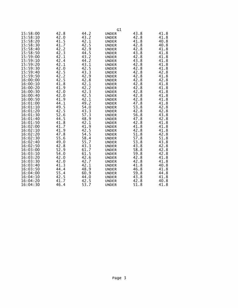
G115:58:00 42.8 44.2 UNDER 43.8 41.815:58:10 42.0 43.2 UNDER 42.8 41.815:58:20 41.5 42.1 UNDER 41.8 40.815:58:30 41.7 42.5 UNDER 42.8 40.815:58:40 42.2 42.9 UNDER 42.8 41.815:58:50 42.3 44.5 UNDER 43.8 41.815:59:00 42.1 43.2 UNDER 42.8 41.815:59:10 42.4 44.2 UNDER 43.8 41.815:59:20 42.1 43.1 UNDER 42.8 41.815:59:30 42.0 42.5 UNDER 42.8 41.815:59:40 42.5 43.3 UNDER 42.8 42.815:59:50 42.2 42.9 UNDER 42.8 41.816:00:00 42.5 42.8 UNDER 42.8 42.816:00:10 41.8 42.1 UNDER 42.8 41.816:00:20 41.9 42.2 UNDER 42.8 41.816:00:30 42.0 42.3 UNDER 42.8 41.816:00:40 42.0 42.5 UNDER 42.8 41.816:00:50 41.9 42.1 UNDER 42.8 41.816:01:00 44.1 49.2 UNDER 47.8 41.816:01:10 49.5 54.0 UNDER 53.8 42.816:01:20 42.5 43.3 UNDER 42.8 42.816:01:30 52.6 57.3 UNDER 56.8 43.816:01:40 44.5 48.9 UNDER 47.8 42.816:01:50 41.8 42.1 UNDER 42.8 41.816:02:00 41.7 41.9 UNDER 41.8 41.816:02:10 41.9 42.5 UNDER 42.8 41.816:02:20 47.8 54.5 UNDER 51.8 42.816:02:30 55.6 58.4 UNDER 57.8 51.816:02:40 49.0 55.7 UNDER 53.8 43.816:02:50 42.8 43.3 UNDER 43.8 42.816:03:00 52.9 61.7 UNDER 58.8 42.816:03:10 54.0 61.5 UNDER 59.8 42.816:03:20 42.0 42.6 UNDER 42.8 41.816:03:30 42.0 42.7 UNDER 42.8 41.816:03:40 41.3 42.1 UNDER 41.8 40.816:03:50 44.4 48.9 UNDER 46.8 41.816:04:00 55.4 60.9 UNDER 59.8 44.816:04:10 42.5 44.0 UNDER 43.8 41.816:04:20 41.7 42.5 UNDER 42.8 40.816:04:30 46.4 53.7 UNDER 51.8 41.8
Page 3

H1*********************************************************************Filename...............3905Test Location.......... Employee Name.......... Employee Number........ Department............. Calibrator Type........ Calibrator Cal. Date... *********************************************************************
METROSONICS db-3080 V1.20 SERIAL # 3905REPORT PRINTED ON 06/29/12 at 14:00:30
User ID: ______________________________
LOGGING STARTED......06/28/12 at 15:49:00TOTAL LOGGING TIME...0 DAYS 00:16:33LOGGING STOPPED......06/28/12 at 16:05:33TOTAL INTERVALS......100INTERVAL LENGTH......00:00:10
AUTO STOP............NOCLOCK SYNCH..........YESRESPONSE RATE........SLOWFILTER...............A WT.
PRE-TEST CALIBRATION TIME....06/28/12 AT 14:02:42PRE-TEST CALIBRATION RANGE...40.3 TO 140.3 dBPOST-TEST CALIBRATION NOT DONECUTOFF USED FOR TIME HISTORY Lav...NONE
<<< SUMMARY REPORT FOR TEST NUMBER 2 OF 5 >>>
EXCHANGE RATE..........3dBCUTOFFS................ 80dB 90dBCEILING................115dBDOSE CRITERION LEVEL... 90dBDOSE CRITERION LENGTH.. 8 HOURS
Lav............ 42.7dBLav ( 80)...... 40.3dBLav ( 90)...... 40.3dBSEL............ 72.5dB
TWA............ 40.3dBTWA ( 80)...... 40.3dBTWA ( 90)...... 40.3dB
Lmax........... 54.0dB 06/28/12 at 15:55:12Lpk............UNDER RANGETIME OVER 115dB...00:00:00.00
Page 1

H1DOSE ( 80)........ 0.00%PROJ. DOSE ( 80).. 0.00%DOSE ( 90)........ 0.00%PROJ. DOSE ( 90).. 0.00%
<<< TIME HISTORY REPORT FOR TEST NUMBER 2 OF 5 >>>
TIME Lav Lmax Lpk L(10.0) L(99.9) dBA dBA dBC dBA dBA06/28/1215:49:00 41.1 42.0 UNDER 41.3 40.315:49:10 40.7 41.0 UNDER 40.3 40.315:49:20 40.7 41.2 UNDER 40.3 40.315:49:30 40.7 41.0 UNDER 40.3 40.315:49:40 40.7 40.9 UNDER 40.3 40.315:49:50 40.7 41.1 UNDER 40.3 40.315:50:00 40.7 41.1 UNDER 40.3 40.315:50:10 40.6 40.8 UNDER 40.3 40.315:50:20 40.5 40.8 UNDER 40.3 40.315:50:30 40.7 40.8 UNDER 40.3 40.315:50:40 40.8 41.2 UNDER 41.3 40.315:50:50 40.7 41.1 UNDER 40.3 40.315:51:00 40.7 40.8 UNDER 40.3 40.315:51:10 40.8 40.9 UNDER 40.3 40.315:51:20 41.1 41.6 UNDER 41.3 40.315:51:30 41.2 41.6 UNDER 41.3 40.315:51:40 41.4 41.6 UNDER 41.3 41.315:51:50 41.2 42.0 UNDER 41.3 41.315:52:00 41.2 41.9 UNDER 41.3 40.315:52:10 40.8 41.1 UNDER 40.3 40.315:52:20 40.8 41.2 UNDER 41.3 40.315:52:30 40.8 41.0 UNDER 40.3 40.315:52:40 41.0 41.2 UNDER 41.3 40.315:52:50 40.9 41.2 UNDER 41.3 40.315:53:00 40.8 41.2 UNDER 41.3 40.315:53:10 41.3 42.0 UNDER 41.3 40.315:53:20 41.3 41.6 UNDER 41.3 40.315:53:30 41.5 42.1 UNDER 42.3 41.315:53:40 41.5 42.3 UNDER 42.3 41.315:53:50 43.5 44.7 UNDER 44.3 42.315:54:00 44.4 45.6 UNDER 45.3 43.315:54:10 43.7 45.2 UNDER 44.3 42.315:54:20 42.2 43.2 UNDER 42.3 41.315:54:30 42.1 42.6 UNDER 42.3 41.315:54:40 42.5 43.6 UNDER 43.3 41.315:54:50 43.7 44.8 UNDER 44.3 42.315:55:00 48.3 52.8 UNDER 51.3 43.315:55:10 51.0 54.0 UNDER 53.3 48.315:55:20 50.4 53.6 UNDER 52.3 48.315:55:30 47.4 52.0 UNDER 50.3 44.315:55:40 43.1 46.0 UNDER 44.3 41.315:55:50 41.6 42.8 UNDER 42.3 40.315:56:00 41.4 42.4 UNDER 41.3 40.315:56:10 41.5 42.5 UNDER 42.3 40.315:56:20 41.5 42.4 UNDER 42.3 40.315:56:30 43.4 45.2 UNDER 44.3 41.315:56:40 44.5 47.6 UNDER 46.3 41.315:56:50 44.8 47.6 UNDER 47.3 41.315:57:00 41.6 42.3 UNDER 42.3 41.315:57:10 42.0 43.3 UNDER 42.3 41.315:57:20 41.2 42.8 UNDER 42.3 40.315:57:30 41.4 43.2 UNDER 42.3 40.3
Page 2

H115:57:40 43.4 45.7 UNDER 45.3 41.315:57:50 41.9 43.1 UNDER 42.3 41.315:58:00 42.5 43.6 UNDER 43.3 41.315:58:10 42.7 43.2 UNDER 42.3 42.315:58:20 42.8 43.8 UNDER 43.3 42.315:58:30 42.7 43.8 UNDER 43.3 42.315:58:40 45.1 50.0 UNDER 47.3 42.315:58:50 46.8 50.4 UNDER 49.3 43.315:59:00 42.3 43.2 UNDER 42.3 41.315:59:10 41.4 41.6 UNDER 41.3 41.315:59:20 42.8 46.0 UNDER 44.3 41.315:59:30 41.0 41.8 UNDER 41.3 40.315:59:40 41.3 42.4 UNDER 41.3 40.315:59:50 40.8 41.2 UNDER 41.3 40.316:00:00 41.2 41.6 UNDER 41.3 40.316:00:10 40.9 41.2 UNDER 41.3 40.316:00:20 40.8 41.0 UNDER 40.3 40.316:00:30 41.1 41.6 UNDER 41.3 40.316:00:40 41.2 42.1 UNDER 41.3 40.316:00:50 40.9 41.2 UNDER 41.3 40.316:01:00 41.1 41.4 UNDER 41.3 40.316:01:10 41.1 41.3 UNDER 41.3 40.316:01:20 40.9 41.1 UNDER 41.3 40.316:01:30 40.9 41.2 UNDER 41.3 40.316:01:40 41.3 41.6 UNDER 41.3 40.316:01:50 41.8 42.0 UNDER 42.3 41.316:02:00 43.5 49.0 UNDER 48.3 41.316:02:10 45.2 47.8 UNDER 47.3 42.316:02:20 42.3 43.6 UNDER 43.3 41.316:02:30 41.9 42.8 UNDER 42.3 41.316:02:40 41.3 41.9 UNDER 41.3 41.316:02:50 40.7 41.1 UNDER 40.3 40.316:03:00 40.4 40.7 UNDER 40.3 40.316:03:10 40.6 41.1 UNDER 40.3 40.316:03:20 40.8 41.1 UNDER 41.3 40.316:03:30 40.8 41.1 UNDER 40.3 40.316:03:40 40.6 40.8 UNDER 40.3 40.316:03:50 40.7 41.0 UNDER 40.3 40.316:04:00 40.7 41.0 UNDER 40.3 40.316:04:10 40.9 42.0 UNDER 41.3 40.316:04:20 44.5 48.0 UNDER 46.3 41.316:04:30 41.1 41.6 UNDER 41.3 40.316:04:40 41.9 43.2 UNDER 42.3 41.316:04:50 41.5 42.0 UNDER 41.3 41.316:05:00 41.7 43.6 UNDER 42.3 41.316:05:10 41.1 42.2 UNDER 41.3 40.316:05:20 41.5 42.7 UNDER 42.3 40.316:05:30 42.0 42.4 UNDER 42.3 41.3
Page 3

J1*********************************************************************Filename...............3908Test Location.......... Employee Name.......... Employee Number........ Department............. Calibrator Type........ Calibrator Cal. Date... *********************************************************************
METROSONICS db-3080 V1.12 SERIAL # 3908REPORT PRINTED ON 06/29/12 at 14:01:47
User ID: ______________________________
LOGGING STARTED......06/28/12 at 15:47:00TOTAL LOGGING TIME...0 DAYS 00:20:06LOGGING STOPPED......06/28/12 at 16:07:06TOTAL INTERVALS......121INTERVAL LENGTH......00:00:10
AUTO STOP............NOCLOCK SYNCH..........YESRESPONSE RATE........SLOWFILTER...............A WT.
PRE-TEST CALIBRATION TIME....06/28/12 AT 13:59:41PRE-TEST CALIBRATION RANGE...38.9 TO 138.9 dBPOST-TEST CALIBRATION NOT DONECUTOFF USED FOR TIME HISTORY Lav...NONE
<<< SUMMARY REPORT FOR TEST NUMBER 3 OF 5 >>>
EXCHANGE RATE..........3dBCUTOFFS................ 80dB 90dBCEILING................115dBDOSE CRITERION LEVEL... 90dBDOSE CRITERION LENGTH.. 8 HOURS
Lav............ 45.1dBLav ( 80)...... 38.9dBLav ( 90)...... 38.9dBSEL............ 75.8dB
TWA............ 38.9dBTWA ( 80)...... 38.9dBTWA ( 90)...... 38.9dB
Lmax........... 61.4dB 06/28/12 at 16:05:26Lpk............UNDER RANGETIME OVER 115dB...00:00:00.00
Page 1

J1DOSE ( 80)........ 0.00%PROJ. DOSE ( 80).. 0.00%DOSE ( 90)........ 0.00%PROJ. DOSE ( 90).. 0.00%
<<< TIME HISTORY REPORT FOR TEST NUMBER 3 OF 5 >>>
TIME Lav Lmax Lpk L(10.0) L(99.9) dBA dBA dBC dBA dBA06/28/1215:47:00 42.9 47.3 UNDER 45.9 41.915:47:10 41.2 43.0 UNDER 42.9 40.915:47:20 41.8 42.8 UNDER 42.9 41.915:47:30 42.1 44.2 UNDER 43.9 40.915:47:40 41.1 42.6 UNDER 42.9 40.915:47:50 41.5 42.9 UNDER 42.9 40.915:48:00 41.5 42.9 UNDER 42.9 41.915:48:10 46.7 53.4 UNDER 51.9 40.915:48:20 45.9 50.2 UNDER 49.9 41.915:48:30 44.1 47.8 UNDER 46.9 41.915:48:40 43.4 45.3 UNDER 44.9 40.915:48:50 41.4 43.4 UNDER 42.9 40.915:49:00 40.9 42.1 UNDER 41.9 40.915:49:10 43.1 48.2 UNDER 46.9 40.915:49:20 41.6 43.0 UNDER 42.9 40.915:49:30 43.0 45.8 UNDER 44.9 41.915:49:40 41.0 42.1 UNDER 41.9 40.915:49:50 42.0 44.3 UNDER 43.9 40.915:50:00 42.0 44.8 UNDER 43.9 40.915:50:10 42.6 45.4 UNDER 44.9 40.915:50:20 41.6 42.9 UNDER 42.9 40.915:50:30 41.3 43.0 UNDER 42.9 40.915:50:40 40.9 42.6 UNDER 42.9 40.915:50:50 42.0 43.7 UNDER 43.9 40.915:51:00 42.9 46.2 UNDER 45.9 40.915:51:10 44.6 48.2 UNDER 46.9 41.915:51:20 45.0 47.3 UNDER 46.9 41.915:51:30 47.4 49.8 UNDER 49.9 44.915:51:40 42.5 45.4 UNDER 44.9 40.915:51:50 41.7 43.3 UNDER 42.9 40.915:52:00 43.9 45.4 UNDER 44.9 42.915:52:10 50.9 56.3 UNDER 55.9 44.915:52:20 52.6 56.2 UNDER 55.9 43.915:52:30 42.6 44.1 UNDER 43.9 41.915:52:40 41.5 42.0 UNDER 41.9 41.915:52:50 41.4 42.2 UNDER 42.9 40.915:53:00 43.0 46.2 UNDER 45.9 40.915:53:10 48.2 53.2 UNDER 49.9 44.915:53:20 52.0 55.0 UNDER 54.9 49.915:53:30 50.4 53.5 UNDER 52.9 46.915:53:40 48.7 51.5 UNDER 50.9 45.915:53:50 45.0 47.8 UNDER 46.9 43.915:54:00 42.8 45.5 UNDER 43.9 41.915:54:10 44.3 49.6 UNDER 46.9 41.915:54:20 41.5 43.4 UNDER 42.9 40.915:54:30 42.4 44.2 UNDER 43.9 41.915:54:40 42.0 44.2 UNDER 43.9 40.915:54:50 42.0 43.0 UNDER 42.9 40.915:55:00 42.3 43.2 UNDER 42.9 41.915:55:10 42.2 43.2 UNDER 43.9 41.915:55:20 42.0 43.0 UNDER 42.9 40.915:55:30 41.6 43.4 UNDER 42.9 40.9
Page 2

J115:55:40 42.3 44.8 UNDER 43.9 41.915:55:50 42.5 45.4 UNDER 44.9 40.915:56:00 42.4 44.6 UNDER 43.9 40.915:56:10 43.4 47.0 UNDER 45.9 41.915:56:20 42.2 43.4 UNDER 42.9 41.915:56:30 42.1 43.0 UNDER 42.9 41.915:56:40 41.9 42.6 UNDER 42.9 41.915:56:50 42.0 44.6 UNDER 43.9 41.915:57:00 42.7 44.6 UNDER 43.9 41.915:57:10 42.8 44.7 UNDER 44.9 41.915:57:20 42.1 43.7 UNDER 43.9 41.915:57:30 41.8 43.1 UNDER 42.9 40.915:57:40 41.2 42.2 UNDER 41.9 40.915:57:50 41.0 42.2 UNDER 41.9 40.915:58:00 41.7 42.9 UNDER 42.9 40.915:58:10 41.0 42.2 UNDER 41.9 40.915:58:20 40.8 41.7 UNDER 41.9 40.915:58:30 41.1 42.7 UNDER 41.9 40.915:58:40 41.5 43.3 UNDER 42.9 40.915:58:50 42.4 44.4 UNDER 43.9 41.915:59:00 42.7 46.6 UNDER 44.9 40.915:59:10 41.9 44.1 UNDER 43.9 40.915:59:20 41.5 42.6 UNDER 42.9 40.915:59:30 42.5 46.1 UNDER 44.9 40.915:59:40 42.0 45.4 UNDER 44.9 40.915:59:50 41.6 44.9 UNDER 43.9 40.916:00:00 40.9 41.8 UNDER 41.9 40.916:00:10 42.2 46.5 UNDER 45.9 40.916:00:20 42.1 43.0 UNDER 42.9 41.916:00:30 42.1 43.8 UNDER 42.9 41.916:00:40 42.4 44.2 UNDER 43.9 41.916:00:50 42.3 44.6 UNDER 43.9 40.916:01:00 40.3 41.0 UNDER 40.9 39.916:01:10 40.5 42.2 UNDER 41.9 39.916:01:20 40.3 41.3 UNDER 41.9 39.916:01:30 40.2 40.6 UNDER 40.9 39.916:01:40 41.9 44.2 UNDER 43.9 40.916:01:50 41.6 43.0 UNDER 42.9 40.916:02:00 40.7 43.8 UNDER 41.9 39.916:02:10 40.5 41.8 UNDER 41.9 39.916:02:20 40.9 42.1 UNDER 41.9 40.916:02:30 42.2 44.6 UNDER 43.9 41.916:02:40 41.6 42.2 UNDER 42.9 41.916:02:50 41.8 42.8 UNDER 42.9 41.916:03:00 40.8 41.9 UNDER 41.9 40.916:03:10 40.9 41.2 UNDER 41.9 40.916:03:20 41.9 43.0 UNDER 42.9 40.916:03:30 41.9 43.0 UNDER 42.9 41.916:03:40 41.4 42.3 UNDER 41.9 40.916:03:50 42.1 43.3 UNDER 42.9 41.916:04:00 42.7 43.8 UNDER 43.9 41.916:04:10 42.2 43.8 UNDER 43.9 41.916:04:20 42.5 43.6 UNDER 43.9 41.916:04:30 41.9 43.7 UNDER 43.9 41.916:04:40 41.9 44.1 UNDER 42.9 41.916:04:50 47.5 50.1 UNDER 49.9 44.916:05:00 48.1 50.7 UNDER 50.9 44.916:05:10 54.5 58.1 UNDER 57.9 48.916:05:20 57.1 61.4 UNDER 59.9 51.916:05:30 54.2 60.3 UNDER 58.9 47.916:05:40 48.8 50.9 UNDER 50.9 47.916:05:50 47.5 51.8 UNDER 50.9 43.916:06:00 47.3 55.4 UNDER 52.9 42.9
Page 3

J116:06:10 43.6 49.4 UNDER 46.9 41.916:06:20 41.1 41.8 UNDER 41.9 40.916:06:30 41.0 41.3 UNDER 41.9 40.916:06:40 40.9 41.5 UNDER 41.9 40.916:06:50 42.4 46.2 UNDER 44.9 40.916:07:00 46.6 49.3 UNDER 48.9 44.9
Page 4

J2*********************************************************************Filename...............3903Test Location.......... Employee Name.......... Employee Number........ Department............. Calibrator Type........ Calibrator Cal. Date... *********************************************************************
METROSONICS db-3080 V1.12 SERIAL # 3903REPORT PRINTED ON 06/29/12 at 14:02:53
User ID: ______________________________
LOGGING STARTED......06/28/12 at 15:45:20TOTAL LOGGING TIME...0 DAYS 00:18:18LOGGING STOPPED......06/28/12 at 16:03:38TOTAL INTERVALS......110INTERVAL LENGTH......00:00:10
AUTO STOP............NOCLOCK SYNCH..........YESRESPONSE RATE........SLOWFILTER...............A WT.
PRE-TEST CALIBRATION TIME....06/28/12 AT 13:58:19PRE-TEST CALIBRATION RANGE...39.5 TO 139.5 dBPOST-TEST CALIBRATION NOT DONECUTOFF USED FOR TIME HISTORY Lav...NONE
<<< SUMMARY REPORT FOR TEST NUMBER 2 OF 5 >>>
EXCHANGE RATE..........3dBCUTOFFS................ 80dB 90dBCEILING................115dBDOSE CRITERION LEVEL... 90dBDOSE CRITERION LENGTH.. 8 HOURS
Lav............ 43.9dBLav ( 80)...... 39.5dBLav ( 90)...... 39.5dBSEL............ 74.3dB
TWA............ 39.5dBTWA ( 80)...... 39.5dBTWA ( 90)...... 39.5dB
Lmax........... 55.2dB 06/28/12 at 15:53:23Lpk............UNDER RANGETIME OVER 115dB...00:00:00.00
Page 1
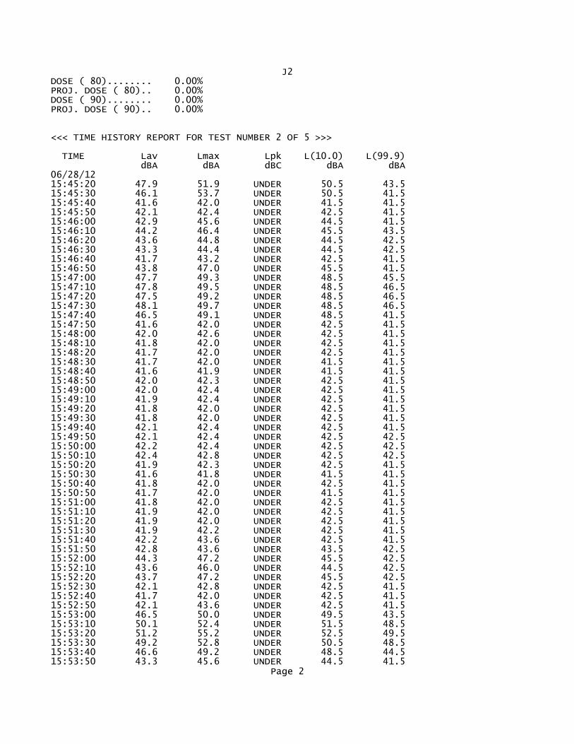
J2DOSE ( 80)........ 0.00%PROJ. DOSE ( 80).. 0.00%DOSE ( 90)........ 0.00%PROJ. DOSE ( 90).. 0.00%
<<< TIME HISTORY REPORT FOR TEST NUMBER 2 OF 5 >>>
TIME Lav Lmax Lpk L(10.0) L(99.9) dBA dBA dBC dBA dBA06/28/1215:45:20 47.9 51.9 UNDER 50.5 43.515:45:30 46.1 53.7 UNDER 50.5 41.515:45:40 41.6 42.0 UNDER 41.5 41.515:45:50 42.1 42.4 UNDER 42.5 41.515:46:00 42.9 45.6 UNDER 44.5 41.515:46:10 44.2 46.4 UNDER 45.5 43.515:46:20 43.6 44.8 UNDER 44.5 42.515:46:30 43.3 44.4 UNDER 44.5 42.515:46:40 41.7 43.2 UNDER 42.5 41.515:46:50 43.8 47.0 UNDER 45.5 41.515:47:00 47.7 49.3 UNDER 48.5 45.515:47:10 47.8 49.5 UNDER 48.5 46.515:47:20 47.5 49.2 UNDER 48.5 46.515:47:30 48.1 49.7 UNDER 48.5 46.515:47:40 46.5 49.1 UNDER 48.5 41.515:47:50 41.6 42.0 UNDER 42.5 41.515:48:00 42.0 42.6 UNDER 42.5 41.515:48:10 41.8 42.0 UNDER 42.5 41.515:48:20 41.7 42.0 UNDER 42.5 41.515:48:30 41.7 42.0 UNDER 41.5 41.515:48:40 41.6 41.9 UNDER 41.5 41.515:48:50 42.0 42.3 UNDER 42.5 41.515:49:00 42.0 42.4 UNDER 42.5 41.515:49:10 41.9 42.4 UNDER 42.5 41.515:49:20 41.8 42.0 UNDER 42.5 41.515:49:30 41.8 42.0 UNDER 42.5 41.515:49:40 42.1 42.4 UNDER 42.5 41.515:49:50 42.1 42.4 UNDER 42.5 42.515:50:00 42.2 42.4 UNDER 42.5 42.515:50:10 42.4 42.8 UNDER 42.5 42.515:50:20 41.9 42.3 UNDER 42.5 41.515:50:30 41.6 41.8 UNDER 41.5 41.515:50:40 41.8 42.0 UNDER 42.5 41.515:50:50 41.7 42.0 UNDER 41.5 41.515:51:00 41.8 42.0 UNDER 42.5 41.515:51:10 41.9 42.0 UNDER 42.5 41.515:51:20 41.9 42.0 UNDER 42.5 41.515:51:30 41.9 42.2 UNDER 42.5 41.515:51:40 42.2 43.6 UNDER 42.5 41.515:51:50 42.8 43.6 UNDER 43.5 42.515:52:00 44.3 47.2 UNDER 45.5 42.515:52:10 43.6 46.0 UNDER 44.5 42.515:52:20 43.7 47.2 UNDER 45.5 42.515:52:30 42.1 42.8 UNDER 42.5 41.515:52:40 41.7 42.0 UNDER 42.5 41.515:52:50 42.1 43.6 UNDER 42.5 41.515:53:00 46.5 50.0 UNDER 49.5 43.515:53:10 50.1 52.4 UNDER 51.5 48.515:53:20 51.2 55.2 UNDER 52.5 49.515:53:30 49.2 52.8 UNDER 50.5 48.515:53:40 46.6 49.2 UNDER 48.5 44.515:53:50 43.3 45.6 UNDER 44.5 41.5
Page 2

J215:54:00 43.4 46.1 UNDER 45.5 41.515:54:10 42.9 45.6 UNDER 44.5 42.515:54:20 44.1 47.2 UNDER 46.5 41.515:54:30 43.1 45.2 UNDER 44.5 41.515:54:40 43.6 46.4 UNDER 45.5 41.515:54:50 43.6 46.8 UNDER 45.5 42.515:55:00 42.2 43.5 UNDER 42.5 41.515:55:10 42.8 43.7 UNDER 43.5 42.515:55:20 45.2 48.0 UNDER 47.5 42.515:55:30 44.6 48.0 UNDER 46.5 42.515:55:40 45.3 48.4 UNDER 47.5 42.515:55:50 44.7 48.0 UNDER 46.5 42.515:56:00 44.9 47.6 UNDER 47.5 43.515:56:10 44.0 47.0 UNDER 46.5 42.515:56:20 45.3 49.2 UNDER 47.5 42.515:56:30 44.5 48.4 UNDER 46.5 42.515:56:40 44.5 47.8 UNDER 46.5 43.515:56:50 44.6 47.3 UNDER 46.5 42.515:57:00 44.5 47.8 UNDER 47.5 42.515:57:10 43.5 46.1 UNDER 45.5 42.515:57:20 44.1 46.3 UNDER 45.5 43.515:57:30 43.1 44.8 UNDER 43.5 42.515:57:40 42.5 43.6 UNDER 43.5 41.515:57:50 42.8 45.6 UNDER 44.5 41.515:58:00 42.0 43.6 UNDER 42.5 41.515:58:10 44.0 46.4 UNDER 45.5 42.515:58:20 42.5 45.5 UNDER 44.5 40.515:58:30 42.4 45.3 UNDER 43.5 41.515:58:40 43.7 46.9 UNDER 46.5 41.515:58:50 44.3 47.1 UNDER 45.5 41.515:59:00 42.7 44.9 UNDER 43.5 41.515:59:10 43.0 44.4 UNDER 44.5 41.515:59:20 42.0 44.2 UNDER 43.5 40.515:59:30 42.5 45.2 UNDER 44.5 40.515:59:40 42.1 44.0 UNDER 42.5 41.515:59:50 42.7 46.0 UNDER 45.5 40.516:00:00 43.2 46.8 UNDER 45.5 40.516:00:10 43.0 46.3 UNDER 44.5 41.516:00:20 43.9 48.1 UNDER 47.5 41.516:00:30 42.7 45.5 UNDER 44.5 41.516:00:40 42.3 44.4 UNDER 43.5 41.516:00:50 42.6 44.4 UNDER 43.5 41.516:01:00 42.0 43.8 UNDER 43.5 41.516:01:10 43.0 45.6 UNDER 44.5 41.516:01:20 42.6 46.0 UNDER 44.5 41.516:01:30 41.3 43.0 UNDER 42.5 40.516:01:40 42.5 45.6 UNDER 44.5 41.516:01:50 41.4 42.8 UNDER 41.5 41.516:02:00 42.9 45.4 UNDER 44.5 41.516:02:10 41.9 43.2 UNDER 42.5 41.516:02:20 42.4 46.0 UNDER 43.5 41.516:02:30 43.1 46.8 UNDER 45.5 41.516:02:40 41.4 42.0 UNDER 42.5 41.516:02:50 42.1 44.8 UNDER 43.5 41.516:03:00 43.0 45.6 UNDER 44.5 41.516:03:10 42.8 45.7 UNDER 44.5 41.516:03:20 44.4 48.8 UNDER 47.5 41.516:03:30 43.0 47.1 UNDER 44.5 40.5
Page 3

K1*********************************************************************Filename...............3903Test Location.......... Employee Name.......... Employee Number........ Department............. Calibrator Type........ Calibrator Cal. Date... *********************************************************************
METROSONICS db-3080 V1.12 SERIAL # 3903REPORT PRINTED ON 06/29/12 at 14:05:06
User ID: ______________________________
LOGGING STARTED......06/28/12 at 19:55:20TOTAL LOGGING TIME...0 DAYS 00:16:51LOGGING STOPPED......06/28/12 at 20:12:11TOTAL INTERVALS......102INTERVAL LENGTH......00:00:10
AUTO STOP............NOCLOCK SYNCH..........YESRESPONSE RATE........SLOWFILTER...............A WT.
PRE-TEST CALIBRATION TIME....06/28/12 AT 13:58:19PRE-TEST CALIBRATION RANGE...39.5 TO 139.5 dBPOST-TEST CALIBRATION NOT DONECUTOFF USED FOR TIME HISTORY Lav...NONE
<<< SUMMARY REPORT FOR TEST NUMBER 5 OF 5 >>>
EXCHANGE RATE..........3dBCUTOFFS................ 80dB 90dBCEILING................115dBDOSE CRITERION LEVEL... 90dBDOSE CRITERION LENGTH.. 8 HOURS
Lav............ 44.9dBLav ( 80)...... 39.5dBLav ( 90)...... 39.5dBSEL............ 74.8dB
TWA............ 39.5dBTWA ( 80)...... 39.5dBTWA ( 90)...... 39.5dB
Lmax........... 62.8dB 06/28/12 at 20:09:48Lpk............UNDER RANGETIME OVER 115dB...00:00:00.00
Page 1

K1DOSE ( 80)........ 0.00%PROJ. DOSE ( 80).. 0.00%DOSE ( 90)........ 0.00%PROJ. DOSE ( 90).. 0.00%
<<< TIME HISTORY REPORT FOR TEST NUMBER 5 OF 5 >>>
TIME Lav Lmax Lpk L(10.0) L(99.9) dBA dBA dBC dBA dBA06/28/1219:55:20 45.8 49.2 UNDER 48.5 41.519:55:30 41.9 43.6 UNDER 42.5 41.519:55:40 42.1 43.8 UNDER 43.5 40.519:55:50 41.3 42.8 UNDER 42.5 40.519:56:00 40.8 41.6 UNDER 41.5 40.519:56:10 40.5 40.8 UNDER 40.5 40.519:56:20 40.5 40.8 UNDER 40.5 40.519:56:30 40.4 40.8 UNDER 40.5 40.519:56:40 41.2 44.0 UNDER 43.5 40.519:56:50 40.5 41.9 UNDER 41.5 40.519:57:00 41.5 43.6 UNDER 42.5 40.519:57:10 40.6 40.8 UNDER 40.5 40.519:57:20 40.6 41.6 UNDER 41.5 40.519:57:30 40.0 40.4 UNDER 40.5 40.519:57:40 40.3 40.8 UNDER 40.5 40.519:57:50 40.7 41.0 UNDER 40.5 40.519:58:00 40.6 41.2 UNDER 40.5 40.519:58:10 40.2 41.2 UNDER 40.5 40.519:58:20 40.3 41.2 UNDER 40.5 40.519:58:30 40.5 41.2 UNDER 40.5 40.519:58:40 41.7 42.0 UNDER 42.5 41.519:58:50 42.0 43.4 UNDER 43.5 40.519:59:00 40.8 41.4 UNDER 41.5 40.519:59:10 41.3 42.8 UNDER 42.5 40.519:59:20 41.8 42.3 UNDER 42.5 41.519:59:30 41.2 41.5 UNDER 41.5 40.519:59:40 41.5 41.7 UNDER 41.5 41.519:59:50 41.0 41.2 UNDER 41.5 40.520:00:00 41.0 41.3 UNDER 41.5 40.520:00:10 40.9 41.2 UNDER 41.5 40.520:00:20 41.0 41.2 UNDER 41.5 40.520:00:30 40.9 41.2 UNDER 41.5 40.520:00:40 41.3 42.3 UNDER 41.5 40.520:00:50 41.0 41.6 UNDER 41.5 40.520:01:00 41.0 41.6 UNDER 41.5 40.520:01:10 41.3 41.6 UNDER 41.5 40.520:01:20 40.8 41.2 UNDER 40.5 40.520:01:30 40.7 40.8 UNDER 40.5 40.520:01:40 40.7 41.2 UNDER 40.5 40.520:01:50 41.0 43.2 UNDER 41.5 40.520:02:00 42.7 48.1 UNDER 45.5 40.520:02:10 42.3 48.0 UNDER 45.5 40.520:02:20 40.7 40.8 UNDER 40.5 40.520:02:30 40.7 40.9 UNDER 40.5 40.520:02:40 41.1 41.6 UNDER 41.5 40.520:02:50 41.1 41.6 UNDER 41.5 40.520:03:00 41.0 41.8 UNDER 41.5 40.520:03:10 41.1 41.8 UNDER 41.5 40.520:03:20 41.2 41.9 UNDER 41.5 40.520:03:30 42.1 45.2 UNDER 44.5 41.520:03:40 41.7 43.2 UNDER 42.5 40.520:03:50 40.7 40.8 UNDER 40.5 40.5
Page 2

K120:04:00 40.9 41.6 UNDER 41.5 40.520:04:10 40.7 40.9 UNDER 40.5 40.520:04:20 40.8 41.1 UNDER 40.5 40.520:04:30 41.3 43.7 UNDER 42.5 40.520:04:40 40.9 41.6 UNDER 41.5 40.520:04:50 40.4 40.9 UNDER 40.5 40.520:05:00 40.1 40.4 UNDER 40.5 39.520:05:10 40.0 40.0 UNDER 40.5 39.520:05:20 39.9 40.1 UNDER 40.5 39.520:05:30 40.0 40.3 UNDER 40.5 39.520:05:40 40.4 40.7 UNDER 40.5 40.520:05:50 40.8 41.2 UNDER 41.5 40.520:06:00 41.1 41.7 UNDER 41.5 40.520:06:10 40.5 42.0 UNDER 40.5 40.520:06:20 40.3 41.2 UNDER 40.5 40.520:06:30 40.0 40.2 UNDER 40.5 40.520:06:40 40.0 40.4 UNDER 40.5 39.520:06:50 40.0 40.1 UNDER 40.5 39.520:07:00 40.6 43.4 UNDER 41.5 39.520:07:10 40.4 40.8 UNDER 40.5 40.520:07:20 41.0 42.8 UNDER 42.5 40.520:07:30 40.7 41.2 UNDER 40.5 40.520:07:40 40.4 40.8 UNDER 40.5 40.520:07:50 40.3 40.5 UNDER 40.5 40.520:08:00 40.8 43.6 UNDER 42.5 39.520:08:10 43.4 47.6 UNDER 46.5 40.520:08:20 44.1 48.8 UNDER 47.5 40.520:08:30 45.5 49.2 UNDER 48.5 40.520:08:40 44.9 48.8 UNDER 48.5 40.520:08:50 44.9 50.0 UNDER 48.5 40.520:09:00 45.1 49.2 UNDER 48.5 40.520:09:10 45.2 50.8 UNDER 49.5 40.520:09:20 47.5 51.6 UNDER 50.5 43.520:09:30 50.2 54.0 UNDER 52.5 44.520:09:40 59.6 62.8 UNDER 61.5 51.520:09:50 57.4 60.4 UNDER 60.5 51.520:10:00 50.0 53.2 UNDER 52.5 47.520:10:10 45.9 52.7 UNDER 49.5 42.520:10:20 42.5 44.4 UNDER 43.5 41.520:10:30 41.8 43.2 UNDER 42.5 40.520:10:40 40.7 43.9 UNDER 41.5 40.520:10:50 40.6 42.8 UNDER 41.5 40.520:11:00 40.6 43.1 UNDER 41.5 39.520:11:10 40.1 40.8 UNDER 40.5 39.520:11:20 40.3 40.8 UNDER 40.5 40.520:11:30 40.1 40.7 UNDER 40.5 39.520:11:40 40.0 41.6 UNDER 40.5 39.520:11:50 39.7 40.0 UNDER 40.5 39.520:12:00 40.1 41.4 UNDER 40.5 39.520:12:10 40.4 40.8 UNDER 40.5 39.5
Page 3

L1*********************************************************************Filename...............3907Test Location.......... Employee Name.......... Employee Number........ Department............. Calibrator Type........ Calibrator Cal. Date... *********************************************************************
METROSONICS db-3080 V1.12 SERIAL # 3907REPORT PRINTED ON 06/29/12 at 14:05:34
User ID: ______________________________
LOGGING STARTED......06/28/12 at 18:17:50TOTAL LOGGING TIME...0 DAYS 00:15:11LOGGING STOPPED......06/28/12 at 18:33:01TOTAL INTERVALS......92INTERVAL LENGTH......00:00:10
AUTO STOP............NOCLOCK SYNCH..........YESRESPONSE RATE........SLOWFILTER...............A WT.
PRE-TEST CALIBRATION TIME....06/28/12 AT 14:02:55PRE-TEST CALIBRATION RANGE...38.8 TO 138.8 dBPOST-TEST CALIBRATION NOT DONECUTOFF USED FOR TIME HISTORY Lav...NONE
<<< SUMMARY REPORT FOR TEST NUMBER 4 OF 5 >>>
EXCHANGE RATE..........3dBCUTOFFS................ 80dB 90dBCEILING................115dBDOSE CRITERION LEVEL... 90dBDOSE CRITERION LENGTH.. 8 HOURS
Lav............ 46.1dBLav ( 80)...... 38.8dBLav ( 90)...... 38.8dBSEL............ 75.6dB
TWA............ 38.8dBTWA ( 80)...... 38.8dBTWA ( 90)...... 38.8dB
Lmax........... 60.1dB 06/28/12 at 18:27:12Lpk............UNDER RANGETIME OVER 115dB...00:00:00.00
Page 1

L1DOSE ( 80)........ 0.00%PROJ. DOSE ( 80).. 0.00%DOSE ( 90)........ 0.00%PROJ. DOSE ( 90).. 0.00%
<<< TIME HISTORY REPORT FOR TEST NUMBER 4 OF 5 >>>
TIME Lav Lmax Lpk L(10.0) L(99.9) dBA dBA dBC dBA dBA06/28/1218:17:50 44.8 45.7 UNDER 45.8 44.818:18:00 43.8 45.7 UNDER 44.8 42.818:18:10 44.5 49.0 UNDER 46.8 42.818:18:20 43.9 46.3 UNDER 45.8 42.818:18:30 42.9 44.6 UNDER 43.8 42.818:18:40 44.6 45.7 UNDER 45.8 43.818:18:50 44.3 47.0 UNDER 46.8 43.818:19:00 42.6 43.2 UNDER 42.8 42.818:19:10 43.9 46.3 UNDER 45.8 42.818:19:20 43.3 44.8 UNDER 44.8 42.818:19:30 43.2 44.3 UNDER 44.8 42.818:19:40 43.5 44.3 UNDER 44.8 42.818:19:50 44.0 44.5 UNDER 44.8 43.818:20:00 45.5 48.1 UNDER 47.8 44.818:20:10 44.8 47.7 UNDER 46.8 43.818:20:20 43.7 45.0 UNDER 44.8 42.818:20:30 42.9 43.3 UNDER 43.8 42.818:20:40 43.0 43.7 UNDER 43.8 42.818:20:50 43.1 43.7 UNDER 43.8 42.818:21:00 43.4 44.2 UNDER 44.8 42.818:21:10 43.4 44.3 UNDER 44.8 42.818:21:20 43.7 44.3 UNDER 44.8 43.818:21:30 43.8 44.9 UNDER 44.8 42.818:21:40 43.9 45.1 UNDER 44.8 42.818:21:50 43.8 45.3 UNDER 44.8 42.818:22:00 46.4 51.7 UNDER 48.8 43.818:22:10 44.0 46.1 UNDER 44.8 42.818:22:20 44.4 46.8 UNDER 46.8 42.818:22:30 43.9 46.1 UNDER 45.8 42.818:22:40 44.4 47.5 UNDER 46.8 42.818:22:50 43.3 44.5 UNDER 43.8 42.818:23:00 42.7 43.3 UNDER 43.8 42.818:23:10 44.0 49.6 UNDER 46.8 42.818:23:20 42.7 44.1 UNDER 43.8 41.818:23:30 42.6 43.2 UNDER 42.8 42.818:23:40 42.6 43.7 UNDER 42.8 42.818:23:50 43.1 44.1 UNDER 43.8 42.818:24:00 45.4 48.7 UNDER 47.8 43.818:24:10 47.4 51.7 UNDER 51.8 44.818:24:20 44.1 45.3 UNDER 44.8 42.818:24:30 43.0 44.5 UNDER 43.8 42.818:24:40 42.8 44.9 UNDER 44.8 41.818:24:50 43.1 44.2 UNDER 43.8 42.818:25:00 42.8 43.7 UNDER 43.8 42.818:25:10 42.8 44.9 UNDER 43.8 42.818:25:20 42.4 42.9 UNDER 42.8 41.818:25:30 43.2 45.3 UNDER 44.8 41.818:25:40 42.3 44.4 UNDER 43.8 41.818:25:50 43.4 46.2 UNDER 45.8 41.818:26:00 43.1 44.0 UNDER 43.8 42.818:26:10 45.5 51.7 UNDER 48.8 42.818:26:20 44.7 48.1 UNDER 46.8 42.8
Page 2

L118:26:30 47.1 52.2 UNDER 49.8 42.818:26:40 48.5 53.2 UNDER 51.8 43.818:26:50 51.5 54.1 UNDER 53.8 48.818:27:00 53.8 57.1 UNDER 55.8 49.818:27:10 56.7 60.1 UNDER 58.8 53.818:27:20 55.0 57.8 UNDER 57.8 50.818:27:30 52.5 58.1 UNDER 55.8 48.818:27:40 48.0 49.8 UNDER 49.8 45.818:27:50 46.7 48.9 UNDER 48.8 44.818:28:00 50.2 56.7 UNDER 55.8 44.818:28:10 46.5 52.6 UNDER 49.8 43.818:28:20 43.1 43.7 UNDER 43.8 42.818:28:30 44.0 46.9 UNDER 45.8 42.818:28:40 47.7 54.2 UNDER 50.8 42.818:28:50 44.2 45.3 UNDER 44.8 43.818:29:00 45.5 47.8 UNDER 47.8 43.818:29:10 45.5 46.7 UNDER 46.8 44.818:29:20 45.4 49.3 UNDER 48.8 42.818:29:30 42.8 43.3 UNDER 43.8 42.818:29:40 42.3 43.5 UNDER 42.8 41.818:29:50 42.2 43.3 UNDER 42.8 41.818:30:00 44.8 48.9 UNDER 47.8 42.818:30:10 42.6 43.6 UNDER 43.8 42.818:30:20 42.7 43.5 UNDER 43.8 42.818:30:30 42.6 43.1 UNDER 42.8 42.818:30:40 43.4 46.5 UNDER 45.8 42.818:30:50 42.6 43.3 UNDER 43.8 42.818:31:00 42.6 43.6 UNDER 42.8 42.818:31:10 44.2 48.1 UNDER 46.8 42.818:31:20 43.3 44.5 UNDER 44.8 42.818:31:30 43.0 44.7 UNDER 43.8 42.818:31:40 42.9 43.7 UNDER 43.8 42.818:31:50 43.0 43.7 UNDER 43.8 42.818:32:00 43.7 45.4 UNDER 44.8 42.818:32:10 44.2 46.9 UNDER 45.8 43.818:32:20 43.7 44.2 UNDER 44.8 43.818:32:30 47.3 54.1 UNDER 51.8 43.818:32:40 46.0 48.8 UNDER 47.8 44.818:32:50 46.4 50.5 UNDER 48.8 44.818:33:00 47.0 47.8 UNDER 47.8 46.8
Page 3

L2*********************************************************************Filename...............3905Test Location.......... Employee Name.......... Employee Number........ Department............. Calibrator Type........ Calibrator Cal. Date... *********************************************************************
METROSONICS db-3080 V1.20 SERIAL # 3905REPORT PRINTED ON 06/29/12 at 14:08:13
User ID: ______________________________
LOGGING STARTED......06/28/12 at 18:17:20TOTAL LOGGING TIME...0 DAYS 00:16:13LOGGING STOPPED......06/28/12 at 18:33:33TOTAL INTERVALS......98INTERVAL LENGTH......00:00:10
AUTO STOP............NOCLOCK SYNCH..........YESRESPONSE RATE........SLOWFILTER...............A WT.
PRE-TEST CALIBRATION TIME....06/28/12 AT 14:02:42PRE-TEST CALIBRATION RANGE...40.3 TO 140.3 dBPOST-TEST CALIBRATION NOT DONECUTOFF USED FOR TIME HISTORY Lav...NONE
<<< SUMMARY REPORT FOR TEST NUMBER 4 OF 5 >>>
EXCHANGE RATE..........3dBCUTOFFS................ 80dB 90dBCEILING................115dBDOSE CRITERION LEVEL... 90dBDOSE CRITERION LENGTH.. 8 HOURS
Lav............ 61.6dBLav ( 80)...... 40.3dBLav ( 90)...... 40.3dBSEL............ 91.4dB
TWA............ 46.9dBTWA ( 80)...... 40.3dBTWA ( 90)...... 40.3dB
Lmax........... 68.9dB 06/28/12 at 18:19:19Lpk............UNDER RANGETIME OVER 115dB...00:00:00.00
Page 1

L2DOSE ( 80)........ 0.00%PROJ. DOSE ( 80).. 0.00%DOSE ( 90)........ 0.00%PROJ. DOSE ( 90).. 0.00%
<<< TIME HISTORY REPORT FOR TEST NUMBER 4 OF 5 >>>
TIME Lav Lmax Lpk L(10.0) L(99.9) dBA dBA dBC dBA dBA06/28/1218:17:20 61.4 62.4 UNDER 62.3 60.318:17:30 62.4 64.0 UNDER 63.3 60.318:17:40 61.2 62.4 UNDER 62.3 59.318:17:50 57.2 59.7 UNDER 59.3 54.318:18:00 57.3 59.2 UNDER 58.3 56.318:18:10 57.9 58.8 UNDER 58.3 56.318:18:20 58.8 60.7 UNDER 60.3 56.318:18:30 58.2 61.9 UNDER 60.3 54.318:18:40 61.8 62.8 UNDER 62.3 60.318:18:50 59.6 60.8 UNDER 60.3 58.318:19:00 61.8 62.8 UNDER 62.3 59.318:19:10 65.5 68.9 UNDER 68.3 61.318:19:20 64.8 68.6 UNDER 67.3 61.318:19:30 61.0 62.8 UNDER 62.3 59.318:19:40 61.8 62.9 UNDER 62.3 60.318:19:50 63.2 66.0 UNDER 65.3 61.318:20:00 63.7 65.6 UNDER 65.3 61.318:20:10 61.6 64.1 UNDER 63.3 59.318:20:20 61.3 62.0 UNDER 61.3 60.318:20:30 63.1 66.8 UNDER 65.3 61.318:20:40 65.3 67.2 UNDER 67.3 62.318:20:50 62.0 64.9 UNDER 64.3 60.318:21:00 62.9 64.5 UNDER 63.3 62.318:21:10 63.4 64.8 UNDER 64.3 62.318:21:20 62.6 64.0 UNDER 63.3 61.318:21:30 61.6 63.2 UNDER 63.3 59.318:21:40 57.7 59.2 UNDER 58.3 56.318:21:50 59.8 61.2 UNDER 61.3 57.318:22:00 58.6 60.4 UNDER 60.3 54.318:22:10 58.7 61.0 UNDER 60.3 54.318:22:20 60.5 62.0 UNDER 62.3 58.318:22:30 58.3 58.9 UNDER 58.3 57.318:22:40 61.3 66.2 UNDER 65.3 57.318:22:50 63.2 66.2 UNDER 65.3 61.318:23:00 61.4 62.8 UNDER 62.3 59.318:23:10 59.0 60.6 UNDER 60.3 57.318:23:20 63.7 65.9 UNDER 65.3 58.318:23:30 62.9 64.3 UNDER 64.3 60.318:23:40 62.3 63.8 UNDER 63.3 59.318:23:50 62.2 64.0 UNDER 63.3 60.318:24:00 61.8 62.5 UNDER 62.3 61.318:24:10 59.7 62.0 UNDER 61.3 57.318:24:20 58.9 60.3 UNDER 60.3 56.318:24:30 59.2 60.2 UNDER 60.3 57.318:24:40 58.8 61.2 UNDER 60.3 57.318:24:50 60.7 62.8 UNDER 62.3 58.318:25:00 60.0 62.8 UNDER 61.3 57.318:25:10 61.7 64.0 UNDER 63.3 55.318:25:20 58.9 61.0 UNDER 60.3 54.318:25:30 62.0 62.7 UNDER 62.3 60.318:25:40 61.7 63.5 UNDER 63.3 59.318:25:50 62.2 63.2 UNDER 62.3 60.3
Page 2

L218:26:00 62.8 64.8 UNDER 64.3 60.318:26:10 62.1 63.2 UNDER 63.3 59.318:26:20 60.1 62.9 UNDER 62.3 58.318:26:30 64.7 67.0 UNDER 66.3 62.318:26:40 62.2 64.8 UNDER 63.3 60.318:26:50 61.1 62.8 UNDER 62.3 59.318:27:00 60.6 61.7 UNDER 61.3 59.318:27:10 59.8 61.2 UNDER 61.3 58.318:27:20 58.5 60.4 UNDER 60.3 57.318:27:30 61.9 63.2 UNDER 62.3 58.318:27:40 61.9 62.9 UNDER 62.3 60.318:27:50 64.4 67.6 UNDER 67.3 59.318:28:00 59.2 60.9 UNDER 60.3 56.318:28:10 58.6 60.8 UNDER 60.3 56.318:28:20 62.6 64.9 UNDER 64.3 59.318:28:30 61.1 61.6 UNDER 61.3 60.318:28:40 62.3 64.9 UNDER 64.3 60.318:28:50 60.3 64.1 UNDER 63.3 56.318:29:00 59.4 61.2 UNDER 60.3 57.318:29:10 63.4 65.2 UNDER 64.3 61.318:29:20 63.3 65.2 UNDER 65.3 61.318:29:30 62.1 64.5 UNDER 64.3 59.318:29:40 60.2 62.0 UNDER 62.3 57.318:29:50 57.8 58.8 UNDER 58.3 56.318:30:00 58.5 60.0 UNDER 59.3 56.318:30:10 59.2 61.1 UNDER 60.3 58.318:30:20 61.0 62.3 UNDER 62.3 58.318:30:30 58.2 60.8 UNDER 60.3 55.318:30:40 62.3 63.2 UNDER 63.3 60.318:30:50 61.6 62.5 UNDER 62.3 60.318:31:00 62.4 63.0 UNDER 62.3 61.318:31:10 62.2 63.7 UNDER 63.3 61.318:31:20 65.0 66.8 UNDER 66.3 61.318:31:30 63.2 64.8 UNDER 64.3 57.318:31:40 56.7 57.7 UNDER 57.3 55.318:31:50 57.7 60.0 UNDER 59.3 56.318:32:00 59.4 63.2 UNDER 62.3 55.318:32:10 62.4 64.4 UNDER 63.3 60.318:32:20 61.9 64.8 UNDER 63.3 60.318:32:30 63.6 65.2 UNDER 65.3 61.318:32:40 60.9 63.2 UNDER 62.3 58.318:32:50 63.4 65.2 UNDER 64.3 60.318:33:00 62.3 63.5 UNDER 63.3 59.318:33:10 60.8 62.3 UNDER 62.3 59.318:33:20 61.5 63.8 UNDER 63.3 58.318:33:30 60.5 61.9 UNDER 61.3 59.3
Page 3

M1*********************************************************************Filename...............3908Test Location.......... Employee Name.......... Employee Number........ Department............. Calibrator Type........ Calibrator Cal. Date... *********************************************************************
METROSONICS db-3080 V1.12 SERIAL # 3908REPORT PRINTED ON 06/29/12 at 14:09:29
User ID: ______________________________
LOGGING STARTED......06/28/12 at 18:56:30TOTAL LOGGING TIME...0 DAYS 00:17:54LOGGING STOPPED......06/28/12 at 19:14:24TOTAL INTERVALS......108INTERVAL LENGTH......00:00:10
AUTO STOP............NOCLOCK SYNCH..........YESRESPONSE RATE........SLOWFILTER...............A WT.
PRE-TEST CALIBRATION TIME....06/28/12 AT 13:59:41PRE-TEST CALIBRATION RANGE...38.9 TO 138.9 dBPOST-TEST CALIBRATION NOT DONECUTOFF USED FOR TIME HISTORY Lav...NONE
<<< SUMMARY REPORT FOR TEST NUMBER 5 OF 5 >>>
EXCHANGE RATE..........3dBCUTOFFS................ 80dB 90dBCEILING................115dBDOSE CRITERION LEVEL... 90dBDOSE CRITERION LENGTH.. 8 HOURS
Lav............ 47.8dBLav ( 80)...... 38.9dBLav ( 90)...... 38.9dBSEL............ 78.0dB
TWA............ 38.9dBTWA ( 80)...... 38.9dBTWA ( 90)...... 38.9dB
Lmax........... 60.1dB 06/28/12 at 19:10:34Lpk............UNDER RANGETIME OVER 115dB...00:00:00.00
Page 1

M1DOSE ( 80)........ 0.00%PROJ. DOSE ( 80).. 0.00%DOSE ( 90)........ 0.00%PROJ. DOSE ( 90).. 0.00%
<<< TIME HISTORY REPORT FOR TEST NUMBER 5 OF 5 >>>
TIME Lav Lmax Lpk L(10.0) L(99.9) dBA dBA dBC dBA dBA06/28/1218:56:30 51.5 59.0 UNDER 55.9 47.918:56:40 48.9 49.0 UNDER 49.9 48.918:56:50 48.7 49.0 UNDER 49.9 48.918:57:00 48.7 49.0 UNDER 48.9 48.918:57:10 49.0 49.7 UNDER 49.9 48.918:57:20 49.4 50.5 UNDER 49.9 48.918:57:30 48.9 49.0 UNDER 49.9 48.918:57:40 49.1 49.4 UNDER 49.9 48.918:57:50 49.1 49.6 UNDER 49.9 48.918:58:00 49.8 53.7 UNDER 51.9 48.918:58:10 49.2 49.4 UNDER 49.9 49.918:58:20 47.2 50.2 UNDER 49.9 45.918:58:30 46.1 47.7 UNDER 47.9 45.918:58:40 45.4 46.0 UNDER 45.9 45.918:58:50 45.1 45.4 UNDER 45.9 44.918:59:00 44.9 45.4 UNDER 45.9 44.918:59:10 44.8 45.4 UNDER 45.9 44.918:59:20 44.9 45.2 UNDER 45.9 44.918:59:30 44.7 45.4 UNDER 45.9 43.918:59:40 44.8 45.4 UNDER 45.9 43.918:59:50 45.0 45.4 UNDER 45.9 44.919:00:00 44.9 45.8 UNDER 45.9 44.919:00:10 44.6 45.2 UNDER 45.9 44.919:00:20 44.9 45.3 UNDER 45.9 44.919:00:30 45.3 47.0 UNDER 46.9 44.919:00:40 45.3 46.6 UNDER 46.9 44.919:00:50 45.1 47.0 UNDER 46.9 43.919:01:00 45.2 46.5 UNDER 46.9 43.919:01:10 45.5 46.2 UNDER 46.9 44.919:01:20 46.5 47.0 UNDER 47.9 46.919:01:30 48.3 50.1 UNDER 49.9 45.919:01:40 49.7 50.2 UNDER 50.9 49.919:01:50 49.9 50.3 UNDER 50.9 49.919:02:00 49.4 49.8 UNDER 49.9 49.919:02:10 49.4 49.7 UNDER 49.9 49.919:02:20 49.2 49.4 UNDER 49.9 49.919:02:30 49.4 49.8 UNDER 49.9 49.919:02:40 49.5 49.8 UNDER 49.9 49.919:02:50 49.9 50.2 UNDER 50.9 49.919:03:00 49.8 50.2 UNDER 50.9 49.919:03:10 49.6 50.1 UNDER 49.9 49.919:03:20 49.8 50.4 UNDER 50.9 49.919:03:30 49.5 50.0 UNDER 49.9 49.919:03:40 50.0 50.6 UNDER 50.9 49.919:03:50 49.6 49.8 UNDER 49.9 49.919:04:00 49.4 49.7 UNDER 49.9 49.919:04:10 49.4 49.8 UNDER 49.9 49.919:04:20 49.5 50.3 UNDER 50.9 49.919:04:30 49.7 50.1 UNDER 49.9 49.919:04:40 48.6 50.2 UNDER 49.9 45.919:04:50 46.0 47.3 UNDER 47.9 45.919:05:00 46.5 47.0 UNDER 46.9 45.9
Page 2

M119:05:10 45.9 46.6 UNDER 46.9 45.919:05:20 46.1 47.0 UNDER 46.9 45.919:05:30 45.1 45.7 UNDER 45.9 44.919:05:40 44.7 45.0 UNDER 44.9 44.919:05:50 44.9 45.4 UNDER 45.9 44.919:06:00 45.2 45.6 UNDER 45.9 45.919:06:10 46.1 46.8 UNDER 46.9 45.919:06:20 46.4 47.4 UNDER 47.9 45.919:06:30 49.5 51.4 UNDER 50.9 47.919:06:40 46.2 48.1 UNDER 47.9 45.919:06:50 45.3 45.8 UNDER 45.9 44.919:07:00 45.9 46.2 UNDER 46.9 45.919:07:10 45.4 46.0 UNDER 45.9 45.919:07:20 44.9 46.5 UNDER 45.9 44.919:07:30 45.1 47.2 UNDER 46.9 44.919:07:40 44.9 45.9 UNDER 45.9 44.919:07:50 44.5 45.2 UNDER 44.9 44.919:08:00 45.2 45.8 UNDER 45.9 44.919:08:10 48.4 51.4 UNDER 50.9 45.919:08:20 49.3 50.2 UNDER 50.9 47.919:08:30 49.6 50.2 UNDER 49.9 49.919:08:40 49.3 50.1 UNDER 49.9 49.919:08:50 49.0 49.4 UNDER 49.9 48.919:09:00 49.1 49.4 UNDER 49.9 48.919:09:10 49.2 49.4 UNDER 49.9 48.919:09:20 49.4 49.7 UNDER 49.9 49.919:09:30 49.3 49.6 UNDER 49.9 49.919:09:40 49.3 49.7 UNDER 49.9 49.919:09:50 49.4 50.2 UNDER 49.9 48.919:10:00 49.0 51.0 UNDER 49.9 48.919:10:10 49.1 50.2 UNDER 49.9 48.919:10:20 49.1 50.6 UNDER 50.9 48.919:10:30 52.5 60.1 UNDER 56.9 48.919:10:40 49.6 50.2 UNDER 50.9 49.919:10:50 49.4 49.8 UNDER 49.9 49.919:11:00 49.2 50.5 UNDER 49.9 48.919:11:10 46.5 49.4 UNDER 47.9 45.919:11:20 45.7 46.6 UNDER 46.9 45.919:11:30 45.2 45.7 UNDER 45.9 44.919:11:40 45.6 45.8 UNDER 45.9 45.919:11:50 45.3 45.9 UNDER 45.9 45.919:12:00 45.8 46.2 UNDER 46.9 45.919:12:10 45.4 46.1 UNDER 45.9 44.919:12:20 46.5 48.1 UNDER 47.9 45.919:12:30 45.6 45.8 UNDER 45.9 45.919:12:40 46.1 46.6 UNDER 46.9 45.919:12:50 46.0 47.0 UNDER 46.9 45.919:13:00 45.3 46.1 UNDER 45.9 44.919:13:10 45.8 46.6 UNDER 46.9 45.919:13:20 45.7 46.1 UNDER 46.9 45.919:13:30 45.1 45.4 UNDER 45.9 44.919:13:40 44.9 45.3 UNDER 45.9 44.919:13:50 44.7 45.0 UNDER 45.9 44.919:14:00 45.6 50.9 UNDER 48.9 43.919:14:10 44.4 45.4 UNDER 45.9 43.919:14:20 45.9 47.7 UNDER 47.9 44.9
Page 3

O1*********************************************************************Filename...............3907Test Location.......... Employee Name.......... Employee Number........ Department............. Calibrator Type........ Calibrator Cal. Date... *********************************************************************
METROSONICS db-3080 V1.12 SERIAL # 3907REPORT PRINTED ON 06/29/12 at 14:12:18
User ID: ______________________________
LOGGING STARTED......06/28/12 at 19:05:40TOTAL LOGGING TIME...0 DAYS 00:15:33LOGGING STOPPED......06/28/12 at 19:21:13TOTAL INTERVALS......94INTERVAL LENGTH......00:00:10
AUTO STOP............NOCLOCK SYNCH..........YESRESPONSE RATE........SLOWFILTER...............A WT.
PRE-TEST CALIBRATION TIME....06/28/12 AT 14:02:55PRE-TEST CALIBRATION RANGE...38.8 TO 138.8 dBPOST-TEST CALIBRATION NOT DONECUTOFF USED FOR TIME HISTORY Lav...NONE
<<< SUMMARY REPORT FOR TEST NUMBER 5 OF 5 >>>
EXCHANGE RATE..........3dBCUTOFFS................ 80dB 90dBCEILING................115dBDOSE CRITERION LEVEL... 90dBDOSE CRITERION LENGTH.. 8 HOURS
Lav............ 50.7dBLav ( 80)...... 38.8dBLav ( 90)...... 38.8dBSEL............ 80.3dB
TWA............ 38.8dBTWA ( 80)...... 38.8dBTWA ( 90)...... 38.8dB
Lmax........... 56.7dB 06/28/12 at 19:18:44Lpk............UNDER RANGETIME OVER 115dB...00:00:00.00
Page 1
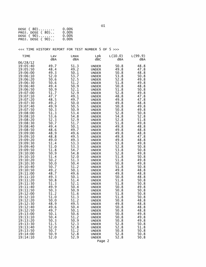
O1DOSE ( 80)........ 0.00%PROJ. DOSE ( 80).. 0.00%DOSE ( 90)........ 0.00%PROJ. DOSE ( 90).. 0.00%
<<< TIME HISTORY REPORT FOR TEST NUMBER 5 OF 5 >>>
TIME Lav Lmax Lpk L(10.0) L(99.9) dBA dBA dBC dBA dBA06/28/1219:05:40 49.7 51.3 UNDER 50.8 48.819:05:50 48.4 49.2 UNDER 49.8 47.819:06:00 49.3 50.1 UNDER 50.8 48.819:06:10 52.0 53.7 UNDER 53.8 50.819:06:20 50.6 52.5 UNDER 52.8 49.819:06:30 50.6 51.2 UNDER 51.8 49.819:06:40 49.4 50.9 UNDER 50.8 48.819:06:50 50.9 52.1 UNDER 51.8 50.819:07:00 51.7 52.9 UNDER 52.8 49.819:07:10 47.7 49.1 UNDER 48.8 47.819:07:20 48.5 49.7 UNDER 49.8 47.819:07:30 49.2 50.0 UNDER 49.8 48.819:07:40 49.9 50.5 UNDER 50.8 49.819:07:50 50.3 50.9 UNDER 50.8 49.819:08:00 51.3 53.4 UNDER 52.8 50.819:08:10 53.6 54.8 UNDER 54.8 52.819:08:20 52.3 52.9 UNDER 52.8 51.819:08:30 50.7 51.7 UNDER 51.8 49.819:08:40 49.4 50.1 UNDER 49.8 48.819:08:50 48.6 49.7 UNDER 49.8 48.819:09:00 48.9 49.6 UNDER 49.8 48.819:09:10 48.8 49.5 UNDER 49.8 47.819:09:20 49.0 49.3 UNDER 49.8 48.819:09:30 51.4 53.3 UNDER 53.8 49.819:09:40 51.0 53.3 UNDER 52.8 50.819:09:50 51.8 54.7 UNDER 53.8 50.819:10:00 50.9 54.8 UNDER 52.8 49.819:10:10 51.4 52.0 UNDER 51.8 50.819:10:20 50.2 51.3 UNDER 51.8 49.819:10:30 50.0 50.4 UNDER 50.8 49.819:10:40 50.7 51.2 UNDER 51.8 50.819:10:50 49.2 50.1 UNDER 49.8 48.819:11:00 48.7 49.6 UNDER 49.8 48.819:11:10 49.3 50.1 UNDER 50.8 48.819:11:20 50.8 51.4 UNDER 51.8 50.819:11:30 51.3 52.1 UNDER 51.8 50.819:11:40 49.9 50.4 UNDER 50.8 49.819:11:50 50.3 50.9 UNDER 50.8 50.819:12:00 51.2 51.6 UNDER 51.8 50.819:12:10 51.0 51.3 UNDER 51.8 50.819:12:20 50.0 51.2 UNDER 50.8 48.819:12:30 48.9 49.5 UNDER 49.8 48.819:12:40 49.6 50.4 UNDER 50.8 48.819:12:50 49.7 50.1 UNDER 50.8 48.819:13:00 50.1 50.6 UNDER 50.8 49.819:13:10 50.4 51.2 UNDER 50.8 49.819:13:20 50.3 50.9 UNDER 50.8 49.819:13:30 51.5 52.3 UNDER 52.8 50.819:13:40 52.0 52.8 UNDER 52.8 51.819:13:50 50.7 51.2 UNDER 50.8 50.819:14:00 50.9 52.8 UNDER 52.8 50.819:14:10 52.0 52.9 UNDER 52.8 50.8
Page 2
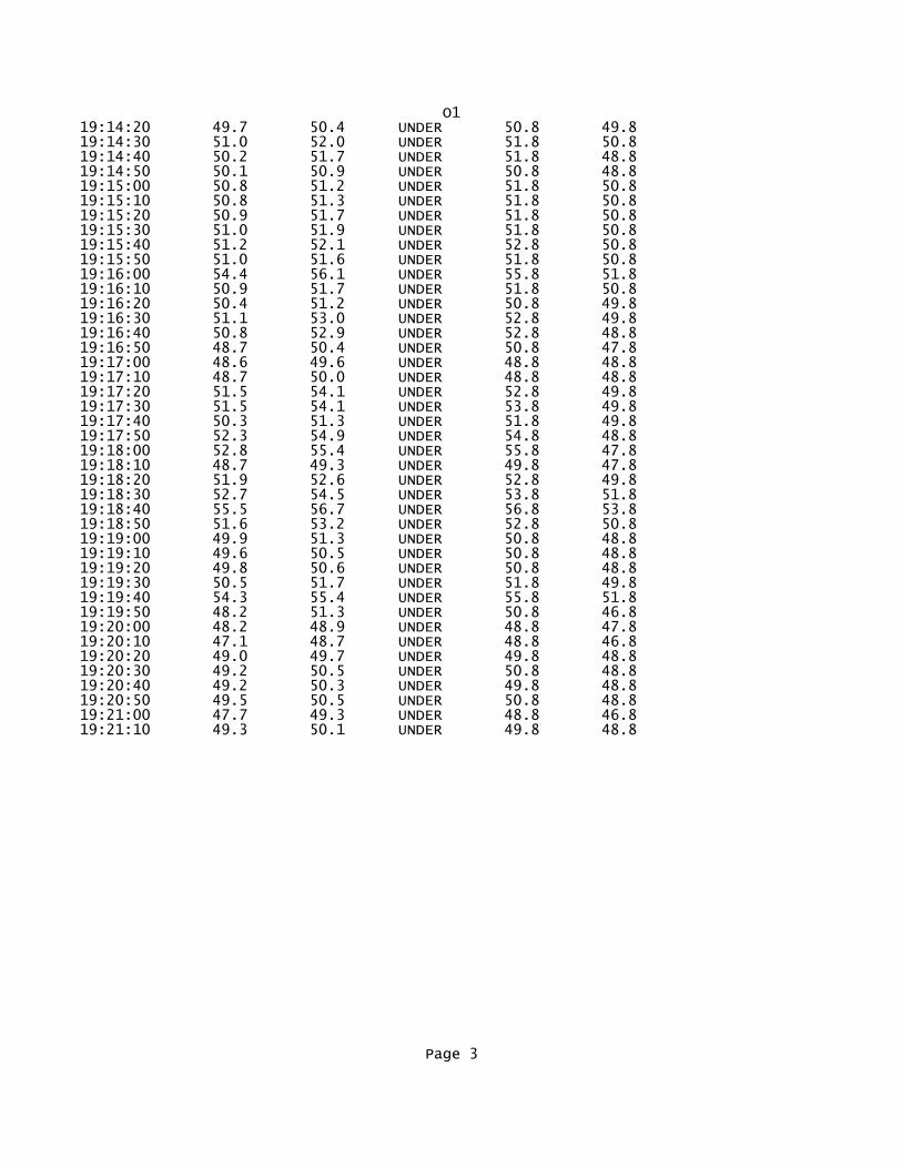
O119:14:20 49.7 50.4 UNDER 50.8 49.819:14:30 51.0 52.0 UNDER 51.8 50.819:14:40 50.2 51.7 UNDER 51.8 48.819:14:50 50.1 50.9 UNDER 50.8 48.819:15:00 50.8 51.2 UNDER 51.8 50.819:15:10 50.8 51.3 UNDER 51.8 50.819:15:20 50.9 51.7 UNDER 51.8 50.819:15:30 51.0 51.9 UNDER 51.8 50.819:15:40 51.2 52.1 UNDER 52.8 50.819:15:50 51.0 51.6 UNDER 51.8 50.819:16:00 54.4 56.1 UNDER 55.8 51.819:16:10 50.9 51.7 UNDER 51.8 50.819:16:20 50.4 51.2 UNDER 50.8 49.819:16:30 51.1 53.0 UNDER 52.8 49.819:16:40 50.8 52.9 UNDER 52.8 48.819:16:50 48.7 50.4 UNDER 50.8 47.819:17:00 48.6 49.6 UNDER 48.8 48.819:17:10 48.7 50.0 UNDER 48.8 48.819:17:20 51.5 54.1 UNDER 52.8 49.819:17:30 51.5 54.1 UNDER 53.8 49.819:17:40 50.3 51.3 UNDER 51.8 49.819:17:50 52.3 54.9 UNDER 54.8 48.819:18:00 52.8 55.4 UNDER 55.8 47.819:18:10 48.7 49.3 UNDER 49.8 47.819:18:20 51.9 52.6 UNDER 52.8 49.819:18:30 52.7 54.5 UNDER 53.8 51.819:18:40 55.5 56.7 UNDER 56.8 53.819:18:50 51.6 53.2 UNDER 52.8 50.819:19:00 49.9 51.3 UNDER 50.8 48.819:19:10 49.6 50.5 UNDER 50.8 48.819:19:20 49.8 50.6 UNDER 50.8 48.819:19:30 50.5 51.7 UNDER 51.8 49.819:19:40 54.3 55.4 UNDER 55.8 51.819:19:50 48.2 51.3 UNDER 50.8 46.819:20:00 48.2 48.9 UNDER 48.8 47.819:20:10 47.1 48.7 UNDER 48.8 46.819:20:20 49.0 49.7 UNDER 49.8 48.819:20:30 49.2 50.5 UNDER 50.8 48.819:20:40 49.2 50.3 UNDER 49.8 48.819:20:50 49.5 50.5 UNDER 50.8 48.819:21:00 47.7 49.3 UNDER 48.8 46.819:21:10 49.3 50.1 UNDER 49.8 48.8
Page 3

P1*********************************************************************Filename...............3905Test Location.......... Employee Name.......... Employee Number........ Department............. Calibrator Type........ Calibrator Cal. Date... *********************************************************************
METROSONICS db-3080 V1.20 SERIAL # 3905REPORT PRINTED ON 06/29/12 at 14:12:50
User ID: ______________________________
LOGGING STARTED......06/28/12 at 19:05:40TOTAL LOGGING TIME...0 DAYS 00:15:46LOGGING STOPPED......06/28/12 at 19:21:26TOTAL INTERVALS......95INTERVAL LENGTH......00:00:10
AUTO STOP............NOCLOCK SYNCH..........YESRESPONSE RATE........SLOWFILTER...............A WT.
PRE-TEST CALIBRATION TIME....06/28/12 AT 14:02:42PRE-TEST CALIBRATION RANGE...40.3 TO 140.3 dBPOST-TEST CALIBRATION NOT DONECUTOFF USED FOR TIME HISTORY Lav...NONE
<<< SUMMARY REPORT FOR TEST NUMBER 5 OF 5 >>>
EXCHANGE RATE..........3dBCUTOFFS................ 80dB 90dBCEILING................115dBDOSE CRITERION LEVEL... 90dBDOSE CRITERION LENGTH.. 8 HOURS
Lav............ 64.5dBLav ( 80)...... 40.3dBLav ( 90)...... 40.3dBSEL............ 94.2dB
TWA............ 49.7dBTWA ( 80)...... 40.3dBTWA ( 90)...... 40.3dB
Lmax........... 73.5dB 06/28/12 at 19:06:15Lpk............UNDER RANGETIME OVER 115dB...00:00:00.00
Page 1

P1DOSE ( 80)........ 0.00%PROJ. DOSE ( 80).. 0.00%DOSE ( 90)........ 0.00%PROJ. DOSE ( 90).. 0.00%
<<< TIME HISTORY REPORT FOR TEST NUMBER 5 OF 5 >>>
TIME Lav Lmax Lpk L(10.0) L(99.9) dBA dBA dBC dBA dBA06/28/1219:05:40 66.5 69.1 UNDER 68.3 64.319:05:50 64.6 67.2 UNDER 66.3 61.319:06:00 67.2 69.0 UNDER 68.3 63.319:06:10 69.3 73.5 UNDER 72.3 65.319:06:20 61.7 66.0 UNDER 65.3 55.319:06:30 58.8 62.3 UNDER 62.3 55.319:06:40 60.9 64.7 UNDER 64.3 55.319:06:50 64.4 66.8 UNDER 66.3 62.319:07:00 64.7 66.4 UNDER 66.3 62.319:07:10 67.5 70.2 UNDER 69.3 63.319:07:20 69.1 71.6 UNDER 71.3 63.319:07:30 67.1 68.7 UNDER 68.3 64.319:07:40 62.4 64.4 UNDER 64.3 60.319:07:50 61.4 64.0 UNDER 63.3 59.319:08:00 54.5 60.0 UNDER 58.3 49.319:08:10 56.1 58.8 UNDER 58.3 50.319:08:20 59.8 63.4 UNDER 62.3 54.319:08:30 54.4 57.2 UNDER 56.3 50.319:08:40 62.9 66.5 UNDER 66.3 56.319:08:50 66.3 68.1 UNDER 68.3 62.319:09:00 66.6 68.4 UNDER 68.3 63.319:09:10 63.5 67.5 UNDER 66.3 57.319:09:20 65.5 68.0 UNDER 67.3 58.319:09:30 63.6 68.0 UNDER 67.3 55.319:09:40 57.0 60.8 UNDER 59.3 54.319:09:50 63.5 66.0 UNDER 65.3 59.319:10:00 58.5 60.6 UNDER 60.3 52.319:10:10 56.7 60.5 UNDER 60.3 52.319:10:20 62.4 66.0 UNDER 65.3 56.319:10:30 67.0 68.6 UNDER 68.3 65.319:10:40 66.7 68.4 UNDER 68.3 64.319:10:50 65.1 66.4 UNDER 66.3 62.319:11:00 65.5 68.3 UNDER 68.3 63.319:11:10 65.0 68.0 UNDER 67.3 60.319:11:20 65.8 67.2 UNDER 66.3 63.319:11:30 64.9 67.1 UNDER 66.3 57.319:11:40 54.4 56.9 UNDER 56.3 52.319:11:50 55.3 58.5 UNDER 57.3 52.319:12:00 60.6 62.0 UNDER 61.3 58.319:12:10 61.4 63.6 UNDER 63.3 58.319:12:20 64.6 67.0 UNDER 66.3 61.319:12:30 64.1 66.0 UNDER 65.3 62.319:12:40 64.8 66.5 UNDER 66.3 62.319:12:50 67.9 69.1 UNDER 68.3 65.319:13:00 64.4 66.4 UNDER 65.3 62.319:13:10 64.6 66.4 UNDER 66.3 63.319:13:20 64.2 66.4 UNDER 66.3 61.319:13:30 62.9 64.7 UNDER 64.3 55.319:13:40 57.1 58.4 UNDER 58.3 53.319:13:50 60.3 62.3 UNDER 62.3 57.319:14:00 64.3 67.2 UNDER 66.3 57.319:14:10 66.2 68.6 UNDER 68.3 62.3
Page 2

P119:14:20 64.6 66.8 UNDER 65.3 62.319:14:30 66.2 68.0 UNDER 67.3 63.319:14:40 66.3 68.8 UNDER 68.3 63.319:14:50 64.4 66.4 UNDER 65.3 62.319:15:00 65.8 66.8 UNDER 66.3 64.319:15:10 65.9 68.8 UNDER 68.3 63.319:15:20 65.5 68.8 UNDER 67.3 63.319:15:30 64.0 66.8 UNDER 66.3 60.319:15:40 65.2 68.8 UNDER 68.3 61.319:15:50 65.9 69.2 UNDER 69.3 62.319:16:00 60.9 65.6 UNDER 63.3 56.319:16:10 59.3 62.0 UNDER 61.3 57.319:16:20 62.7 64.5 UNDER 64.3 58.319:16:30 64.2 66.2 UNDER 66.3 60.319:16:40 63.7 65.6 UNDER 64.3 61.319:16:50 63.4 65.2 UNDER 65.3 60.319:17:00 59.6 62.4 UNDER 62.3 56.319:17:10 57.0 59.6 UNDER 59.3 53.319:17:20 62.3 65.2 UNDER 64.3 57.319:17:30 66.9 69.9 UNDER 69.3 62.319:17:40 66.4 68.2 UNDER 67.3 63.319:17:50 69.6 71.1 UNDER 70.3 67.319:18:00 66.9 70.0 UNDER 69.3 63.319:18:10 66.4 67.8 UNDER 67.3 63.319:18:20 63.9 67.6 UNDER 66.3 62.319:18:30 65.2 67.8 UNDER 67.3 62.319:18:40 61.6 64.4 UNDER 64.3 58.319:18:50 63.8 67.6 UNDER 66.3 60.319:19:00 63.2 68.1 UNDER 67.3 54.319:19:10 58.8 62.0 UNDER 61.3 53.319:19:20 59.4 61.7 UNDER 61.3 56.319:19:30 64.7 67.2 UNDER 67.3 60.319:19:40 64.6 67.4 UNDER 67.3 61.319:19:50 64.3 65.8 UNDER 65.3 62.319:20:00 65.9 68.2 UNDER 68.3 62.319:20:10 60.8 64.8 UNDER 64.3 55.319:20:20 65.2 67.2 UNDER 66.3 61.319:20:30 63.3 67.2 UNDER 67.3 54.319:20:40 56.6 58.5 UNDER 58.3 55.319:20:50 58.2 59.6 UNDER 59.3 56.319:21:00 67.6 72.3 UNDER 72.3 57.319:21:10 68.3 72.0 UNDER 71.3 64.319:21:20 67.3 68.0 UNDER 68.3 66.3
Page 3

Appendix D
TRAFFIC DATA SUMMARY

ADT % Trucks ADT % Trucks ADT % Trucks ADT % Trucks ADT % Trucks67 Route 250 Bypass WB (btwn Hydraulic Rd & Emmet St) 11,500 2.0% 12,314 0.02 11,927 2.0% 16,364 0.02 15,977 0.02
68 Route 250 Bypass EB (btwn Hydraulic Rd & Emmet St) 11,500 2.0% 12,314 0.02 11,927 2.0% 16,364 0.02 15,977 0.02
69 Route 250 Bypass WB (btwn Emmet St & Barracks Rd) 19,000 3.0% 20,717 0.03 13,026 3.0% 29,329 0.03 20,315 0.03
70 Route 250 Bypass EB (btwn Emmet St & Barracks Rd) 19,000 3.0% 20,717 0.03 13,026 3.0% 29,329 0.03 20,315 0.03
77 L. Sandbridge Rd NB, south of 29 500 3.0% 503 3.0% 1,236 3.0% 3,028 3.0% 3,761 3.0%
78 L. Sandbridge Rd SB, south of 29 500 3.0% 503 3.0% 1,236 3.0% 3,028 3.0% 3,761 3.0%
109 Route 250 Bypass WB (btwn Barracks Rd & Prop Route 29 Bypass) 24,000 3.0% 25,888 3.0% 17,122 3.0% 35,325 3.0% 26,559 3.0%
110 Route 250 Bypass EB (btwn Bararcks Rd & Prop Route 29 Bypass) 24,000 3.0% 25,888 3.0% 17,122 3.0% 35,325 3.0% 26,559 3.0%
111 29 NB south of the Bypass (between Fontaine and Ivy) 21,000 7.0% 23,115 7.0% 24,162 7.0% 33,702 7.0% 34,750 7.0%
112 29 SB south of the Bypass (between Fontaine and Ivy) 21,000 7.0% 23,115 7.0% 24,162 7.0% 33,702 7.0% 34,750 7.0%
113 Ivy Rd EB (btwn Rt 250 Bypass & Alderman Rd) 8,000 1.0% 7,711 1.0% 7,171 1.0% 6,261 1.0% 5,721 1.0%
114 Ivy Rd WB (btwn Rt 250 Bypass & Alderman Rd) 8,000 1.0% 7,711 1.0% 7,171 1.0% 6,261 1.0% 5,721 1.0%
115 Ivy Rd WB (btwn Rt 846 & Golf Course Dr) 7,000 2.0% 7,518 2.0% 7,638 2.0% 10,118 2.0% 10,238 2.0%
116 Ivy Rd EB (btwn Rt 846 & Golf Course Dr) 7,000 2.0% 7,518 2.0% 7,638 2.0% 10,118 2.0% 10,238 2.0%
117 Old Ivy Rd EB (btwn Crestwood Rd & Harvest Dr) 2,750 1.0% 2,773 1.0% 2,703 1.0% 2,860 1.0% 2,790 1.0%
118 Old Ivy Rd WB (btwn Crestwood Rd & Harvest Dr) 2,750 1.0% 2,773 1.0% 2,703 1.0% 2,860 1.0% 2,790 1.0%
119 Proposed Bypass NB (South Terminus to North Terminus) 8,900 3.0% 13,899 3.0%
120 Proposed Bypass SB (North Terminus to South Terminus) 8,900 3.0% 13,899 3.0%
152 AB-AC: Off-Ramp from 29 NB to L. Sandridge Rd (diamond) 557 3.0% 762 3.0%
163 AB-AJ: 29 NB to Proposed Bypass NB (flyover) 8,144 3.0% 10,135 3.0%
153 AC-AD: On-Ramp from L. Sandridge Rd to 250 NB (diamond) 394 3.0% 1,930 3.0%
154 AA-AD: 250 Bypass NB (thru lanes) from 29 NB Bypass diverge to On-Ramp from L. Sandridge Rd 16,920 3.0% 24,537 3.0%
157 AE-AH: 250 Bypass SB (thru lanes) from Off-Ramp to L. Sandridge Rd to 29 SB Bypass merge 16,498 3.0% 23,047 3.0%
158 AH-AG: 250 Bypass SB (thru lanes) from 29 SB Bypass merge to On-Ramp from L. Sandridge Rd 24,901 3.0% 34,301 3.0%
155 AE-AF: Off-Ramp from 250 SB to L. Sandridge Rd (diamond) 799 3.0% 3,435 3.0%
156 AF-AG: On-Ramp from L. Sandridge Rd to 29 SB (diamond) 708 3.0% 1,144 3.0%
164 AI-AH: Proposed Bypass SB to 29 SB (flyover) 8,403 3.0% 11,254 3.0%
151 AA-AB: 250 NB to Split 8,701 3.0% 10,897 3.0%
159 AC-AF: L. Sandridge Rd NB, between Ramps 1,112 3.0% 3,066 3.0%
160 AF-AC: L. Sandridge Rd SB, between Ramps 946 3.0% 4,238 3.0%
161 AF-AJ: L. Sandridge Rd NB ramp to Proposed Bypass NB 843 3.0% 3,728 3.0%
162 AI-AF: Proposed Bypass SB ramp to L. Sandridge Rd SB 586 3.0% 2,609 3.0%
109 Route 250 SB/WB Mainline (btwn Ivy Rd & Barracks Rd) - Ex & NB 24,000 3.0% 25,888 3.0% 35,325 3.0%
151 Route 250 SB/WB Mainline (btwn Ivy Rd & 29 Bypass) - Build 25,609 3.0% 35,445 3.0%
110 Route 250 NB/EB Mainline (btwn Ivy Rd & L. Sandridge Rd) - Ex & NB 24,000 3.0% 25,888 3.0% 35,325 3.0%
110 Route 250 NB/EB Mainline (btwn L. Sandridge Rd & Barracks Rd) - Ex & NB 24,000 3.0% 25,888 3.0% 35,325 3.0%
158 Route 250 NB/EB Mainline (btwn Ivy Rd & 29 Bypass) - Build 25,621 3.0% 35,434 3.0%
191 Route 250 SB Off-Ramp (loop) to Ivy Rd 6,315 1.0% 6,341 1.0% 5,706 1.0% 6,631 1.0% 6,073 1.0%
192 Route 250 SB On-Ramp from Ivy Rd 3,353 1.0% 3,612 1.0% 4,011 1.0% 5,058 1.0% 5,516 1.0%
193 Route 250 NB Off-Ramp to Ivy Rd 3,353 1.0% 3,612 1.0% 4,010 1.0% 5,057 1.0% 5,516 1.0%
194 Route 250 NB On-Ramp (loop) from Ivy Rd 6,314 1.0% 6,341 1.0% 5,706 1.0% 6,631 1.0% 6,073 1.0%
119 Proposed Bypass NB (South Terminus to North Terminus) 8,900 3.0% 13,899 3.0%
120 Proposed Bypass SB (North Terminus to South Terminus) 8,900 3.0% 13,899 3.0%
136 Ramp 136: Prop Bypass NB to US 29 SB 972 3.0% 4,464 3.0%
135 Ramp 135: Prop Bypass NB to US 29 NB 7,993 3.0% 9,424 3.0%
133 Ramp 133: US 29 SB to Prop Bypass SB 7,965 3.0% 9,321 3.0%
134 Ramp 134: US 29 NB to Prop Bypass SB (left-exit ramp) 1,003 3.0% 4,565 3.0%
2 29 NB, north of Prop Bypass (south of Hollymead) 24,000 3.0% 25,547 3.0% 29,704 3.0% 33,272 3.0% 37,429 3.0%
1 29 SB, north of Prop Bypass (south of Hollymead) 24,000 3.0% 25,547 3.0% 29,704 3.0% 33,272 3.0% 37,429 3.0%
3 29 Seminole Tr: Polo Grounds Rd to Prop. Bypass (NB) 24,000 3.0% 26,089 3.0% 22,255 3.0% 36,539 3.0% 32,705 3.0%
4 29 Seminole Tr: Polo Grounds Rd to Prop. Bypass (SB) 24,000 3.0% 26,089 3.0% 22,255 3.0% 36,539 3.0% 32,705 3.0%
130 29 Seminole Tr between ramps (NB) 8,900 3.0% 13,899 3.0%
131 29 Seminole Tr between ramps (SB) 21,441 3.0% 28,085 3.0%
109 29/250: Prop Bypass to Barracks Road (SB) 24,000 3.0% 25,888 3.0% 17,122 3.0% 35,325 3.0% 26,559 3.0%
70 29/250: Barracks Road to Emmet Street (NB) 19,000 3.0% 20,717 3.0% 13,026 3.0% 29,329 3.0% 20,315 3.0%
69 29/250: Barracks Road to Emmet Street (SB) 19,000 3.0% 20,717 3.0% 13,026 3.0% 29,329 3.0% 20,315 3.0%
21 29 Seminole Tr: US 250 to Angus Rd (NB) 26,000 3.0% 28,827 3.0% 18,671 3.0% 42,939 3.0% 32,783 3.0%
22 29 Seminole Tr: US 250 to Angus Rd (SB) 26,000 3.0% 28,827 3.0% 18,671 3.0% 42,939 3.0% 32,783 3.0%
19 29 Seminole Tr: Angus Rd to Hydraulic Rd (NB) 26,000 3.0% 28,609 3.0% 18,506 3.0% 41,646 3.0% 31,544 3.0%
20 29 Seminole Tr: Angus Rd to Hydraulic Rd (SB) 26,000 3.0% 28,609 3.0% 18,506 3.0% 41,646 3.0% 31,544 3.0%
17 29 Seminole Tr: Hydraulic Rd to Greenbrier Dr (NB) 28,500 3.0% 30,692 3.0% 22,902 3.0% 41,642 3.0% 33,852 3.0%
18 29 Seminole Tr: Hydraulic Rd to Greenbrier Dr (SB) 28,500 3.0% 30,692 3.0% 22,902 3.0% 41,642 3.0% 33,852 3.0%
15 29 Seminole Tr: Greenbrier Dr to Dominion Dr (NB) 28,500 3.0% 30,780 3.0% 20,063 3.0% 42,180 3.0% 31,463 3.0%
16 29 Seminole Tr: Greenbrier Dr to Dominion Dr (SB) 28,500 3.0% 30,780 3.0% 20,063 3.0% 42,180 3.0% 31,463 3.0%
13 29 Seminole Tr: Dominion Dr to Berkmar Dr (NB) 28,500 3.0% 30,446 3.0% 19,519 3.0% 40,158 3.0% 29,231 3.0%
14 29 Seminole Tr: Dominion Dr to Berkmar Dr (SB) 28,500 3.0% 30,446 3.0% 19,519 3.0% 40,158 3.0% 29,231 3.0%
11 29 Seminole Tr: Berkmar Dr to Rio Rd (NB) 24,000 3.0% 25,498 3.0% 18,108 3.0% 32,973 3.0% 25,583 3.0%
12 29 Seminole Tr: Berkmar Dr to Rio Rd (SB) 24,000 3.0% 25,498 3.0% 18,108 3.0% 32,973 3.0% 25,583 3.0%
9 29 Seminole Tr: Rio Rd to Woodbrook Dr (NB) 24,000 3.0% 26,753 3.0% 20,522 3.0% 40,528 3.0% 34,297 3.0%
10 29 Seminole Tr: Rio Rd to Woodbrook Dr (SB) 24,000 3.0% 26,753 3.0% 20,522 3.0% 40,528 3.0% 34,297 3.0%
7 29 Seminole Tr: Woodbrook to Carrsbrook/Hilton Hghts (NB) 24,000 3.0% 26,389 3.0% 20,267 3.0% 38,339 3.0% 32,217 3.0%
8 29 Seminole Tr: Woodbrook to Carrsbrook/Hilton Hghts (SB) 24,000 3.0% 26,389 3.0% 20,267 3.0% 38,339 3.0% 32,217 3.0%
5 29 Seminole Tr: Carrsbrook/Hilton Hghts to Polo Grounds (NB) 24,000 3.0% 26,307 3.0% 20,230 3.0% 37,832 3.0% 31,755 3.0%
6 29 Seminole Tr: Carrsbrook/Hilton Hghts to Polo Grounds (SB) 24,000 3.0% 26,307 3.0% 20,230 3.0% 37,832 3.0% 31,755 3.0%
3 29 Seminole Tr: Polo Grounds Rd to Prop. Bypass (NB) 24,000 3.0% 26,089 3.0% 22,255 3.0% 36,539 3.0% 32,705 3.0%
4 29 Seminole Tr: Polo Grounds Rd to Prop. Bypass (SB) 24,000 3.0% 26,089 3.0% 22,255 3.0% 36,539 3.0% 32,705 3.0%
Table 2 - Route 29 Bypass - Average Daily Traffic (ADT) Summary
2011 Existing 2015 No-BuildLink DescriptionSegment
2015 Build 2040 No-Build 2040 Build
Ro
ute
29 B
yp
ass C
orr
ido
rE
xis
tin
g R
ou
te 2
9

ADT % T % of ADT Total Vol Total Truck cars MT HT % of ADT Total Vol Total Truck cars MT HT
84 Barracks Road EB (Btwn Garth Rd & Georgetown Rd) K5 3,200 1.0% 10.1% 324 3 321 1 2 9.6% 306 3 303 1 2
83 Barracks Road WB (Btwn Garth Rd & Georgetown Rd) K6 3,200 1.0% 7.5% 239 2 237 1 1 11.0% 350 4 347 1 3
99 Lambs Road NB (Btwn Hydraulic Rd & Ivy Ridge Rd) K10 2,450 1.0% 5.1% 126 1 125 0 1 11.5% 282 3 279 1 2
100 Lambs Road SB (Btwn Hydraulic Rd & Ivy Ridge Rd) K9 2,450 1.0% 12.9% 316 3 313 1 2 6.0% 146 1 145 0 1
Roslyn Ridge Rd [NOT IN MODEL] 160 1.0% 10.0% 16 0 16 0 0 10.0% 16 0 16 0 0
105 Earlysville Rd NB (Btwn Hydraulic Rd & Woodland Rd) K10 6,000 1.0% 5.1% 308 3 305 1 2 11.5% 690 7 683 2 5
106 Earlysville Rd SB (Btwn Hydraulic Rd & Woodland Rd) K9 6,000 1.0% 12.9% 775 8 767 2 6 6.0% 358 4 354 1 3
Woodburn Road [NOT IN MODEL] 840 1.0% 10.0% 84 1 83 0 1 10.0% 84 1 83 0 1
Parallel Routes
41 Berkmar Drive NB (Btwn Woodbrook Dr & Hilton Heights Rd) K10 4,550 3.0% 5.1% 233 7 226 2 5 11.5% 523 16 507 4 12
42 Berkmar Drive SB (Btwn Woodbrook Dr & Hilton Heights Rd) K9 4,550 3.0% 12.9% 588 18 570 4 14 6.0% 271 8 263 2 6
45 Berkmar Drive SB (btwn Woodbrook Dr & Rio Road) K9 9,500 3.0% 12.9% 1,227 37 1,190 9 28 6.0% 567 17 550 4 13
46 Berkmar Drive NB (btwn Woodbrook Dr & Rio Road) K10 9,500 1.0% 5.1% 487 5 482 1 4 11.5% 1,092 11 1,081 3 8
51 Rio Road EB (btwn 4 Seasons Dr & Berkmar Dr) K5 8,500 1.0% 10.1% 860 9 851 2 7 9.6% 813 8 805 2 6
52 Rio Road WB (btwn 4 Seasons Dr & Berkmar Dr) K6 8,500 1.0% 7.5% 635 6 629 2 4 11.0% 931 9 922 2 7
101 Hydraulic Road SB (Btwn Earlysville Rd & Lambs Rd) K5 10,500 1.0% 10.1% 1,063 11 1,052 3 8 9.6% 1,005 10 995 3 7
102 Hydraulic Road NB (Btwn Earlysville Rd & Lambs Rd) K6 10,500 1.0% 7.5% 784 8 776 2 6 11.0% 1,150 12 1,139 3 9
103 Rio Rd EB (Btwn Earlysville Rd & 4 Seasons Dr) K5 8,500 1.0% 10.1% 860 9 851 2 7 9.6% 813 8 805 2 6
104 Rio Rd WB (Btwn Earlysville Rd & 4 Seasons Dr) K6 8,500 1.0% 7.5% 635 6 629 2 4 11.0% 931 9 922 2 7
MT = Medium Truck (2 axles with 6 wheels)
HT = Heavy Truck (3 or more axles)
Assume 25% of trucks are MT, and the rest are HT
AM Peak Hour is 8:00 AM to 9:00 AM
PM Peak Hour is 5:00 PM to 6:00 PM
Blue Text indicates segments added (2012-07-11)
Segment Link DescriptionPM Peak HourDiurnal
Curve
Charlottesville Bypass Traffic - Cross Streets
2011 Existing AM Peak Hour
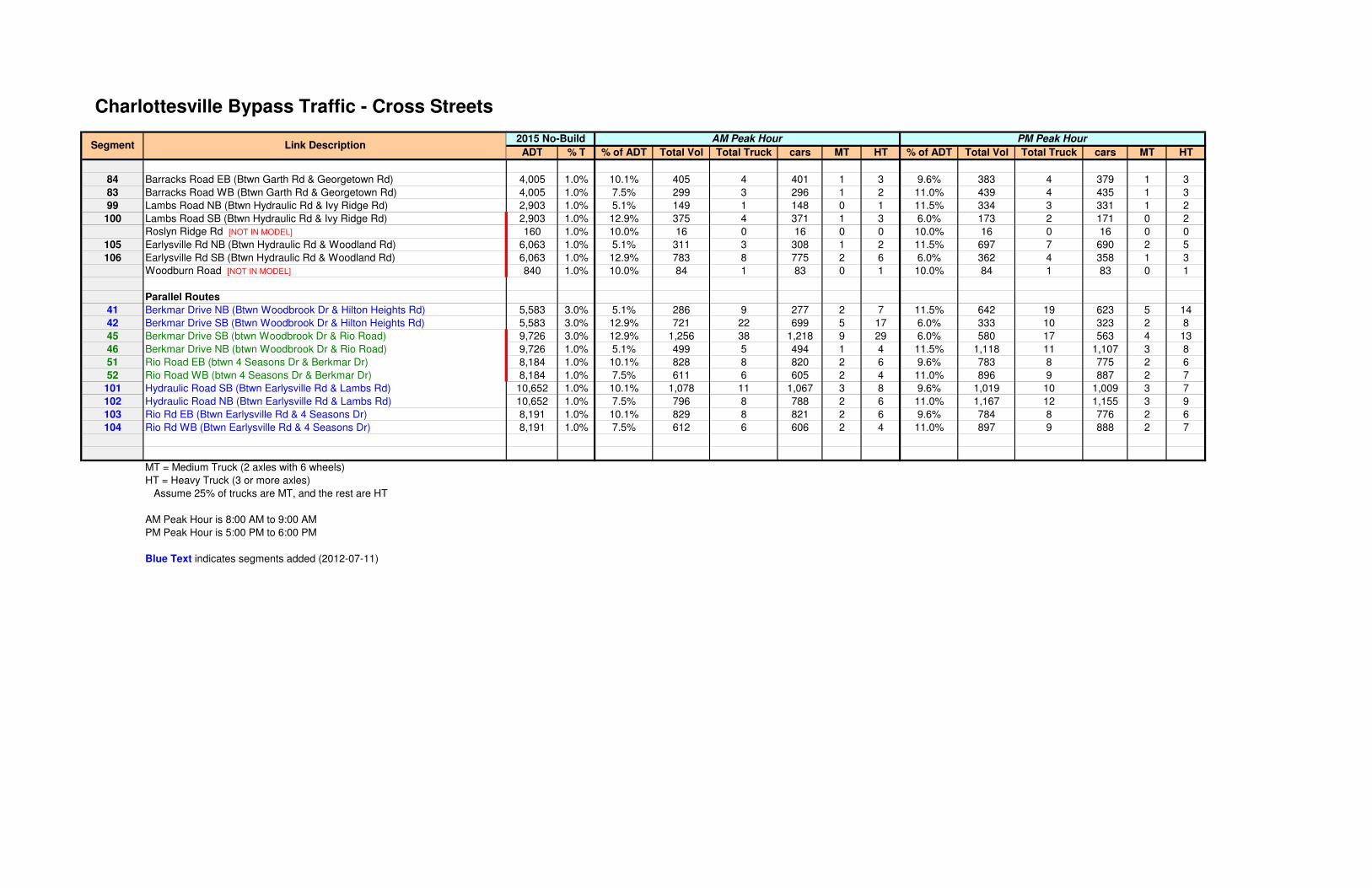
84 Barracks Road EB (Btwn Garth Rd & Georgetown Rd)
83 Barracks Road WB (Btwn Garth Rd & Georgetown Rd)
99 Lambs Road NB (Btwn Hydraulic Rd & Ivy Ridge Rd)
100 Lambs Road SB (Btwn Hydraulic Rd & Ivy Ridge Rd)
Roslyn Ridge Rd [NOT IN MODEL]
105 Earlysville Rd NB (Btwn Hydraulic Rd & Woodland Rd)
106 Earlysville Rd SB (Btwn Hydraulic Rd & Woodland Rd)
Woodburn Road [NOT IN MODEL]
Parallel Routes
41 Berkmar Drive NB (Btwn Woodbrook Dr & Hilton Heights Rd)
42 Berkmar Drive SB (Btwn Woodbrook Dr & Hilton Heights Rd)
45 Berkmar Drive SB (btwn Woodbrook Dr & Rio Road)
46 Berkmar Drive NB (btwn Woodbrook Dr & Rio Road)
51 Rio Road EB (btwn 4 Seasons Dr & Berkmar Dr)
52 Rio Road WB (btwn 4 Seasons Dr & Berkmar Dr)
101 Hydraulic Road SB (Btwn Earlysville Rd & Lambs Rd)
102 Hydraulic Road NB (Btwn Earlysville Rd & Lambs Rd)
103 Rio Rd EB (Btwn Earlysville Rd & 4 Seasons Dr)
104 Rio Rd WB (Btwn Earlysville Rd & 4 Seasons Dr)
MT = Medium Truck (2 axles with 6 wheels)
HT = Heavy Truck (3 or more axles)
Assume 25% of trucks are MT, and the rest are HT
AM Peak Hour is 8:00 AM to 9:00 AM
PM Peak Hour is 5:00 PM to 6:00 PM
Blue Text indicates segments added (2012-07-11)
Segment Link Description
Charlottesville Bypass Traffic - Cross Streets
ADT % T % of ADT Total Vol Total Truck cars MT HT % of ADT Total Vol Total Truck cars MT HT
4,005 1.0% 10.1% 405 4 401 1 3 9.6% 383 4 379 1 3
4,005 1.0% 7.5% 299 3 296 1 2 11.0% 439 4 435 1 3
2,903 1.0% 5.1% 149 1 148 0 1 11.5% 334 3 331 1 2
2,903 1.0% 12.9% 375 4 371 1 3 6.0% 173 2 171 0 2
160 1.0% 10.0% 16 0 16 0 0 10.0% 16 0 16 0 0
6,063 1.0% 5.1% 311 3 308 1 2 11.5% 697 7 690 2 5
6,063 1.0% 12.9% 783 8 775 2 6 6.0% 362 4 358 1 3
840 1.0% 10.0% 84 1 83 0 1 10.0% 84 1 83 0 1
5,583 3.0% 5.1% 286 9 277 2 7 11.5% 642 19 623 5 14
5,583 3.0% 12.9% 721 22 699 5 17 6.0% 333 10 323 2 8
9,726 3.0% 12.9% 1,256 38 1,218 9 29 6.0% 580 17 563 4 13
9,726 1.0% 5.1% 499 5 494 1 4 11.5% 1,118 11 1,107 3 8
8,184 1.0% 10.1% 828 8 820 2 6 9.6% 783 8 775 2 6
8,184 1.0% 7.5% 611 6 605 2 4 11.0% 896 9 887 2 7
10,652 1.0% 10.1% 1,078 11 1,067 3 8 9.6% 1,019 10 1,009 3 7
10,652 1.0% 7.5% 796 8 788 2 6 11.0% 1,167 12 1,155 3 9
8,191 1.0% 10.1% 829 8 821 2 6 9.6% 784 8 776 2 6
8,191 1.0% 7.5% 612 6 606 2 4 11.0% 897 9 888 2 7
PM Peak Hour2015 No-Build AM Peak Hour
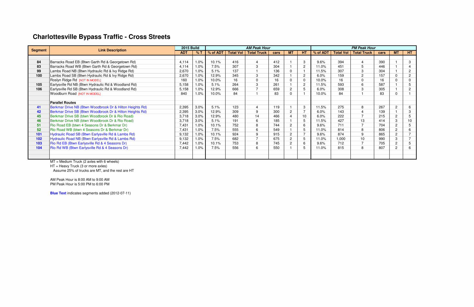
84 Barracks Road EB (Btwn Garth Rd & Georgetown Rd)
83 Barracks Road WB (Btwn Garth Rd & Georgetown Rd)
99 Lambs Road NB (Btwn Hydraulic Rd & Ivy Ridge Rd)
100 Lambs Road SB (Btwn Hydraulic Rd & Ivy Ridge Rd)
Roslyn Ridge Rd [NOT IN MODEL]
105 Earlysville Rd NB (Btwn Hydraulic Rd & Woodland Rd)
106 Earlysville Rd SB (Btwn Hydraulic Rd & Woodland Rd)
Woodburn Road [NOT IN MODEL]
Parallel Routes
41 Berkmar Drive NB (Btwn Woodbrook Dr & Hilton Heights Rd)
42 Berkmar Drive SB (Btwn Woodbrook Dr & Hilton Heights Rd)
45 Berkmar Drive SB (btwn Woodbrook Dr & Rio Road)
46 Berkmar Drive NB (btwn Woodbrook Dr & Rio Road)
51 Rio Road EB (btwn 4 Seasons Dr & Berkmar Dr)
52 Rio Road WB (btwn 4 Seasons Dr & Berkmar Dr)
101 Hydraulic Road SB (Btwn Earlysville Rd & Lambs Rd)
102 Hydraulic Road NB (Btwn Earlysville Rd & Lambs Rd)
103 Rio Rd EB (Btwn Earlysville Rd & 4 Seasons Dr)
104 Rio Rd WB (Btwn Earlysville Rd & 4 Seasons Dr)
MT = Medium Truck (2 axles with 6 wheels)
HT = Heavy Truck (3 or more axles)
Assume 25% of trucks are MT, and the rest are HT
AM Peak Hour is 8:00 AM to 9:00 AM
PM Peak Hour is 5:00 PM to 6:00 PM
Blue Text indicates segments added (2012-07-11)
Segment Link Description
Charlottesville Bypass Traffic - Cross Streets
ADT % T % of ADT Total Vol Total Truck cars MT HT % of ADT Total Vol Total Truck cars MT HT
4,114 1.0% 10.1% 416 4 412 1 3 9.6% 394 4 390 1 3
4,114 1.0% 7.5% 307 3 304 1 2 11.0% 451 5 446 1 4
2,670 1.0% 5.1% 137 1 136 0 1 11.5% 307 3 304 1 2
2,670 1.0% 12.9% 345 3 342 1 2 6.0% 159 2 157 0 2
160 1.0% 10.0% 16 0 16 0 0 10.0% 16 0 16 0 0
5,158 1.0% 5.1% 264 3 261 1 2 11.5% 593 6 587 1 5
5,158 1.0% 12.9% 666 7 659 2 5 6.0% 308 3 305 1 2
840 1.0% 10.0% 84 1 83 0 1 10.0% 84 1 83 0 1
2,395 3.0% 5.1% 123 4 119 1 3 11.5% 275 8 267 2 6
2,395 3.0% 12.9% 309 9 300 2 7 6.0% 143 4 139 1 3
3,718 3.0% 12.9% 480 14 466 4 10 6.0% 222 7 215 2 5
3,718 3.0% 5.1% 191 6 185 1 5 11.5% 427 13 414 3 10
7,431 1.0% 10.1% 752 8 744 2 6 9.6% 711 7 704 2 5
7,431 1.0% 7.5% 555 6 549 1 5 11.0% 814 8 806 2 6
9,132 1.0% 10.1% 924 9 915 2 7 9.6% 874 9 865 2 7
9,132 1.0% 7.5% 682 7 675 2 5 11.0% 1,000 10 990 3 7
7,442 1.0% 10.1% 753 8 745 2 6 9.6% 712 7 705 2 5
7,442 1.0% 7.5% 556 6 550 1 5 11.0% 815 8 807 2 6
PM Peak Hour2015 Build AM Peak Hour

84 Barracks Road EB (Btwn Garth Rd & Georgetown Rd)
83 Barracks Road WB (Btwn Garth Rd & Georgetown Rd)
99 Lambs Road NB (Btwn Hydraulic Rd & Ivy Ridge Rd)
100 Lambs Road SB (Btwn Hydraulic Rd & Ivy Ridge Rd)
Roslyn Ridge Rd [NOT IN MODEL]
105 Earlysville Rd NB (Btwn Hydraulic Rd & Woodland Rd)
106 Earlysville Rd SB (Btwn Hydraulic Rd & Woodland Rd)
Woodburn Road [NOT IN MODEL]
Parallel Routes
41 Berkmar Drive NB (Btwn Woodbrook Dr & Hilton Heights Rd)
42 Berkmar Drive SB (Btwn Woodbrook Dr & Hilton Heights Rd)
45 Berkmar Drive SB (btwn Woodbrook Dr & Rio Road)
46 Berkmar Drive NB (btwn Woodbrook Dr & Rio Road)
51 Rio Road EB (btwn 4 Seasons Dr & Berkmar Dr)
52 Rio Road WB (btwn 4 Seasons Dr & Berkmar Dr)
101 Hydraulic Road SB (Btwn Earlysville Rd & Lambs Rd)
102 Hydraulic Road NB (Btwn Earlysville Rd & Lambs Rd)
103 Rio Rd EB (Btwn Earlysville Rd & 4 Seasons Dr)
104 Rio Rd WB (Btwn Earlysville Rd & 4 Seasons Dr)
MT = Medium Truck (2 axles with 6 wheels)
HT = Heavy Truck (3 or more axles)
Assume 25% of trucks are MT, and the rest are HT
AM Peak Hour is 8:00 AM to 9:00 AM
PM Peak Hour is 5:00 PM to 6:00 PM
Blue Text indicates segments added (2012-07-11)
Segment Link Description
Charlottesville Bypass Traffic - Cross Streets
ADT % T % of ADT Total Vol Total Truck cars MT HT % of ADT Total Vol Total Truck cars MT HT
8,055 1.0% 10.1% 815 8 807 2 6 9.6% 771 8 763 2 6
8,055 1.0% 7.5% 602 6 596 2 4 11.0% 882 9 873 2 7
5,153 1.0% 5.1% 264 3 261 1 2 11.5% 592 6 586 1 5
5,153 1.0% 12.9% 666 7 659 2 5 6.0% 307 3 304 1 2
160 1.0% 10.0% 16 0 16 0 0 10.0% 16 0 16 0 0
6,375 1.0% 5.1% 327 3 324 1 2 11.5% 733 7 726 2 5
6,375 1.0% 12.9% 823 8 815 2 6 6.0% 380 4 376 1 3
840 1.0% 10.0% 84 1 83 0 1 10.0% 84 1 83 0 1
10,745 3.0% 5.1% 551 17 534 4 13 11.5% 1,235 37 1,198 9 28
10,745 3.0% 12.9% 1,388 42 1,346 10 32 6.0% 641 19 622 5 14
10,839 3.0% 12.9% 1,400 42 1,358 11 31 6.0% 646 19 627 5 14
10,839 1.0% 5.1% 556 6 550 1 5 11.5% 1,246 12 1,234 3 9
6,571 1.0% 10.1% 665 7 658 2 5 9.6% 629 6 623 2 4
6,571 1.0% 7.5% 491 5 486 1 4 11.0% 720 7 713 2 5
11,415 1.0% 10.1% 1,155 12 1,143 3 9 9.6% 1,092 11 1,081 3 8
11,415 1.0% 7.5% 853 9 844 2 7 11.0% 1,250 13 1,238 3 10
6,616 1.0% 10.1% 670 7 663 2 5 9.6% 633 6 627 2 4
6,616 1.0% 7.5% 494 5 489 1 4 11.0% 725 7 718 2 5
2040 No-Build AM Peak Hour PM Peak Hour

84 Barracks Road EB (Btwn Garth Rd & Georgetown Rd)
83 Barracks Road WB (Btwn Garth Rd & Georgetown Rd)
99 Lambs Road NB (Btwn Hydraulic Rd & Ivy Ridge Rd)
100 Lambs Road SB (Btwn Hydraulic Rd & Ivy Ridge Rd)
Roslyn Ridge Rd [NOT IN MODEL]
105 Earlysville Rd NB (Btwn Hydraulic Rd & Woodland Rd)
106 Earlysville Rd SB (Btwn Hydraulic Rd & Woodland Rd)
Woodburn Road [NOT IN MODEL]
Parallel Routes
41 Berkmar Drive NB (Btwn Woodbrook Dr & Hilton Heights Rd)
42 Berkmar Drive SB (Btwn Woodbrook Dr & Hilton Heights Rd)
45 Berkmar Drive SB (btwn Woodbrook Dr & Rio Road)
46 Berkmar Drive NB (btwn Woodbrook Dr & Rio Road)
51 Rio Road EB (btwn 4 Seasons Dr & Berkmar Dr)
52 Rio Road WB (btwn 4 Seasons Dr & Berkmar Dr)
101 Hydraulic Road SB (Btwn Earlysville Rd & Lambs Rd)
102 Hydraulic Road NB (Btwn Earlysville Rd & Lambs Rd)
103 Rio Rd EB (Btwn Earlysville Rd & 4 Seasons Dr)
104 Rio Rd WB (Btwn Earlysville Rd & 4 Seasons Dr)
MT = Medium Truck (2 axles with 6 wheels)
HT = Heavy Truck (3 or more axles)
Assume 25% of trucks are MT, and the rest are HT
AM Peak Hour is 8:00 AM to 9:00 AM
PM Peak Hour is 5:00 PM to 6:00 PM
Blue Text indicates segments added (2012-07-11)
Segment Link Description
Charlottesville Bypass Traffic - Cross Streets
ADT % T % of ADT Total Vol Total Truck cars MT HT % of ADT Total Vol Total Truck cars MT HT
8,164 1.0% 10.1% 826 8 818 2 6 9.6% 781 8 773 2 6
8,164 1.0% 7.5% 610 6 604 2 4 11.0% 894 9 885 2 7
4,920 1.0% 5.1% 252 3 249 1 2 11.5% 566 6 560 1 5
4,920 1.0% 12.9% 636 6 630 2 4 6.0% 293 3 290 1 2
160 1.0% 10.0% 16 0 16 0 0 10.0% 16 0 16 0 0
5,471 1.0% 5.1% 281 3 278 1 2 11.5% 629 6 623 2 4
5,471 1.0% 12.9% 707 7 700 2 5 6.0% 326 3 323 1 2
840 1.0% 10.0% 84 1 83 0 1 10.0% 84 1 83 0 1
4,610 3.0% 5.1% 236 7 229 2 5 11.5% 530 16 514 4 12
4,610 3.0% 12.9% 595 18 577 4 14 6.0% 275 8 267 2 6
4,830 3.0% 12.9% 624 19 605 5 14 6.0% 288 9 279 2 7
4,830 3.0% 5.1% 248 7 241 2 5 11.5% 555 17 538 4 13
5,819 1.0% 10.1% 589 6 583 1 5 9.6% 557 6 551 1 5
5,819 1.0% 7.5% 435 4 431 1 3 11.0% 637 6 631 2 4
9,895 1.0% 10.1% 1,002 10 992 3 7 9.6% 947 9 938 2 7
9,895 1.0% 7.5% 739 7 732 2 5 11.0% 1,084 11 1,073 3 8
5,867 1.0% 10.1% 594 6 588 1 5 9.6% 561 6 555 1 5
5,867 1.0% 7.5% 438 4 434 1 3 11.0% 643 6 637 2 4
2040 Build AM Peak Hour PM Peak Hour

ADT % T % of ADT Total Vol Total Truck cars MT HT % of ADT Total Vol Total Truck cars MT HT
119 Proposed Bypass NB (South Terminus to North Terminus) K2
120 Proposed Bypass SB (North Terminus to South Terminus) K1
136 Ramp 136: Prop Bypass NB to US 29 SB K2
135 Ramp 135: Prop Bypass NB to US 29 NB K2
133 Ramp 133: US 29 SB to Prop Bypass SB K1
134 Ramp 134: US 29 NB to Prop Bypass SB (left-exit ramp) K1
2 29 NB, north of Prop Bypass (south of Hollymead) K1 24,000 3.0% 6.2% 1,480 44 1,436 11 33 9.3% 2,228 67 2,161 17 50
1 29 SB, north of Prop Bypass (south of Hollymead) K2 24,000 3.0% 7.2% 1,728 52 1,676 13 39 7.8% 1,865 56 1,809 14 42
3 29 Seminole Tr: Polo Grounds Rd to Prop. Bypass (NB) K2 24,000 3.0% 7.2% 1,728 52 1,676 13 39 7.8% 1,865 56 1,809 14 42
4 29 Seminole Tr: Polo Grounds Rd to Prop. Bypass (SB) K1 24,000 3.0% 6.2% 1,480 44 1,436 11 33 9.3% 2,228 67 2,161 17 50
130 29 Seminole Tr between ramps (NB) K1
131 29 Seminole Tr between ramps (SB) K2
MT = Medium Truck (2 axles with 6 wheels)
HT = Heavy Truck (3 or more axles)
Assume 25% of trucks are MT, and the rest are HT
AM Peak Hour is 8:00 AM to 9:00 AM
PM Peak Hour is 5:00 PM to 6:00 PM
Link DescriptionDiurnal
Curve
Charlottesville Bypass Traffic - Northern
Terminus Area2011 Existing AM Peak Hour PM Peak Hour
Segment

119 Proposed Bypass NB (South Terminus to North Terminus)
120 Proposed Bypass SB (North Terminus to South Terminus)
136 Ramp 136: Prop Bypass NB to US 29 SB
135 Ramp 135: Prop Bypass NB to US 29 NB
133 Ramp 133: US 29 SB to Prop Bypass SB
134 Ramp 134: US 29 NB to Prop Bypass SB (left-exit ramp)
2 29 NB, north of Prop Bypass (south of Hollymead)
1 29 SB, north of Prop Bypass (south of Hollymead)
3 29 Seminole Tr: Polo Grounds Rd to Prop. Bypass (NB)
4 29 Seminole Tr: Polo Grounds Rd to Prop. Bypass (SB)
130 29 Seminole Tr between ramps (NB)
131 29 Seminole Tr between ramps (SB)
MT = Medium Truck (2 axles with 6 wheels)
HT = Heavy Truck (3 or more axles)
Assume 25% of trucks are MT, and the rest are HT
AM Peak Hour is 8:00 AM to 9:00 AM
PM Peak Hour is 5:00 PM to 6:00 PM
Link Description
Charlottesville Bypass Traffic - Northern
Terminus Area
SegmentADT % T % of ADT Total Vol Total Truck cars MT HT % of ADT Total Vol Total Truck cars MT HT
25,547 3.0% 6.2% 1,576 47 1,529 12 35 9.3% 2,371 71 2,300 18 53
25,547 3.0% 7.2% 1,840 55 1,785 14 41 7.8% 1,986 60 1,926 15 45
26,089 3.0% 7.2% 1,879 56 1,823 14 42 7.8% 2,028 61 1,967 15 46
26,089 3.0% 6.2% 1,609 48 1,561 12 36 9.3% 2,422 73 2,349 18 55
2015 No-Build AM Peak Hour PM Peak Hour

119 Proposed Bypass NB (South Terminus to North Terminus)
120 Proposed Bypass SB (North Terminus to South Terminus)
136 Ramp 136: Prop Bypass NB to US 29 SB
135 Ramp 135: Prop Bypass NB to US 29 NB
133 Ramp 133: US 29 SB to Prop Bypass SB
134 Ramp 134: US 29 NB to Prop Bypass SB (left-exit ramp)
2 29 NB, north of Prop Bypass (south of Hollymead)
1 29 SB, north of Prop Bypass (south of Hollymead)
3 29 Seminole Tr: Polo Grounds Rd to Prop. Bypass (NB)
4 29 Seminole Tr: Polo Grounds Rd to Prop. Bypass (SB)
130 29 Seminole Tr between ramps (NB)
131 29 Seminole Tr between ramps (SB)
MT = Medium Truck (2 axles with 6 wheels)
HT = Heavy Truck (3 or more axles)
Assume 25% of trucks are MT, and the rest are HT
AM Peak Hour is 8:00 AM to 9:00 AM
PM Peak Hour is 5:00 PM to 6:00 PM
Link Description
Charlottesville Bypass Traffic - Northern
Terminus Area
SegmentADT % T % of ADT Total Vol Total Truck cars MT HT % of ADT Total Vol Total Truck cars MT HT
8,900 3.0% 7.2% 641 19 622 5 14 7.8% 692 21 671 5 16
8,900 3.0% 6.2% 549 16 533 4 12 9.3% 826 25 801 6 19
972 3.0% 7.2% 70 2 68 1 1 7.8% 76 2 74 1 1
7,993 3.0% 7.2% 576 17 559 4 13 7.8% 621 19 602 5 14
7,965 3.0% 6.2% 491 15 476 4 11 9.3% 739 22 717 6 16
1,003 3.0% 6.2% 62 2 60 0 2 9.3% 93 3 90 1 2
29,704 3.0% 6.2% 1,832 55 1,777 14 41 9.3% 2,757 83 2,674 21 62
29,704 3.0% 7.2% 2,139 64 2,075 16 48 7.8% 2,309 69 2,240 17 52
22,255 3.0% 7.2% 1,603 48 1,555 12 36 7.8% 1,730 52 1,678 13 39
22,255 3.0% 6.2% 1,373 41 1,332 10 31 9.3% 2,066 62 2,004 15 47
8,900 3.0% 6.2% 549 16 533 4 12 9.3% 826 25 801 6 19
21,441 3.0% 7.2% 1,544 46 1,498 12 34 7.8% 1,667 50 1,617 13 37
2015 Build AM Peak Hour PM Peak Hour

119 Proposed Bypass NB (South Terminus to North Terminus)
120 Proposed Bypass SB (North Terminus to South Terminus)
136 Ramp 136: Prop Bypass NB to US 29 SB
135 Ramp 135: Prop Bypass NB to US 29 NB
133 Ramp 133: US 29 SB to Prop Bypass SB
134 Ramp 134: US 29 NB to Prop Bypass SB (left-exit ramp)
2 29 NB, north of Prop Bypass (south of Hollymead)
1 29 SB, north of Prop Bypass (south of Hollymead)
3 29 Seminole Tr: Polo Grounds Rd to Prop. Bypass (NB)
4 29 Seminole Tr: Polo Grounds Rd to Prop. Bypass (SB)
130 29 Seminole Tr between ramps (NB)
131 29 Seminole Tr between ramps (SB)
MT = Medium Truck (2 axles with 6 wheels)
HT = Heavy Truck (3 or more axles)
Assume 25% of trucks are MT, and the rest are HT
AM Peak Hour is 8:00 AM to 9:00 AM
PM Peak Hour is 5:00 PM to 6:00 PM
Link Description
Charlottesville Bypass Traffic - Northern
Terminus Area
SegmentADT % T % of ADT Total Vol Total Truck cars MT HT % of ADT Total Vol Total Truck cars MT HT
33,272 3.0% 6.2% 2,052 62 1,990 15 47 9.3% 3,088 93 2,995 23 70
33,272 3.0% 7.2% 2,396 72 2,324 18 54 7.8% 2,586 78 2,508 19 59
36,539 3.0% 7.2% 2,631 79 2,552 20 59 7.8% 2,840 85 2,755 21 64
36,539 3.0% 6.2% 2,254 68 2,186 17 51 9.3% 3,392 102 3,290 25 77
2040 No-Build AM Peak Hour PM Peak Hour

119 Proposed Bypass NB (South Terminus to North Terminus)
120 Proposed Bypass SB (North Terminus to South Terminus)
136 Ramp 136: Prop Bypass NB to US 29 SB
135 Ramp 135: Prop Bypass NB to US 29 NB
133 Ramp 133: US 29 SB to Prop Bypass SB
134 Ramp 134: US 29 NB to Prop Bypass SB (left-exit ramp)
2 29 NB, north of Prop Bypass (south of Hollymead)
1 29 SB, north of Prop Bypass (south of Hollymead)
3 29 Seminole Tr: Polo Grounds Rd to Prop. Bypass (NB)
4 29 Seminole Tr: Polo Grounds Rd to Prop. Bypass (SB)
130 29 Seminole Tr between ramps (NB)
131 29 Seminole Tr between ramps (SB)
MT = Medium Truck (2 axles with 6 wheels)
HT = Heavy Truck (3 or more axles)
Assume 25% of trucks are MT, and the rest are HT
AM Peak Hour is 8:00 AM to 9:00 AM
PM Peak Hour is 5:00 PM to 6:00 PM
Link Description
Charlottesville Bypass Traffic - Northern
Terminus Area
SegmentADT % T % of ADT Total Vol Total Truck cars MT HT % of ADT Total Vol Total Truck cars MT HT
13,899 3.0% 7.2% 1,001 30 971 8 22 7.8% 1,080 32 1,048 8 24
13,899 3.0% 6.2% 857 26 831 6 20 9.3% 1,290 39 1,251 10 29
4,464 3.0% 7.2% 321 10 311 2 8 7.8% 347 10 337 3 7
9,424 3.0% 7.2% 679 20 659 5 15 7.8% 732 22 710 5 17
9,321 3.0% 6.2% 575 17 558 4 13 9.3% 865 26 839 6 20
4,565 3.0% 6.2% 282 8 274 2 6 9.3% 424 13 411 3 10
37,429 3.0% 6.2% 2,309 69 2,240 17 52 9.3% 3,474 104 3,370 26 78
37,429 3.0% 7.2% 2,696 81 2,615 20 61 7.8% 2,909 87 2,822 22 65
32,705 3.0% 7.2% 2,355 71 2,284 18 53 7.8% 2,542 76 2,466 19 57
32,705 3.0% 6.2% 2,017 61 1,956 15 46 9.3% 3,036 91 2,945 23 68
13,899 3.0% 6.2% 857 26 831 6 20 9.3% 1,290 39 1,251 10 29
28,085 3.0% 7.2% 2,023 61 1,962 15 46 7.8% 2,183 65 2,118 16 49
2040 Build AM Peak Hour PM Peak Hour

ADT Total Vol cars MT HT Total Vol cars MT HT
110 29/250: Prop Bypass to Barracks Road (NB) K5 24,000 2,429 2,356 18 55 2,296 2,227 17 52
109 29/250: Prop Bypass to Barracks Road (SB) K6 24,000 1,793 1,739 13 41 2,629 2,550 20 59
70 29/250: Barracks Road to Emmet Street (NB) K5 19,000 1,923 1,865 14 44 1,818 1,763 14 41
69 29/250: Barracks Road to Emmet Street (SB) K6 19,000 1,419 1,376 11 32 2,081 2,019 16 46
21 29 Seminole Tr: US 250 to Angus Rd (NB) K2 26,000 1,872 1,816 14 42 2,021 1,960 15 46
22 29 Seminole Tr: US 250 to Angus Rd (SB) K1 26,000 1,604 1,556 12 36 2,413 2,341 18 54
19 29 Seminole Tr: Angus Rd to Hydraulic Rd (NB) K2 26,000 1,872 1,816 14 42 2,021 1,960 15 46
20 29 Seminole Tr: Angus Rd to Hydraulic Rd (SB) K1 26,000 1,604 1,556 12 36 2,413 2,341 18 54
17 29 Seminole Tr: Hydraulic Rd to Greenbrier Dr (NB) K2 28,500 2,052 1,990 15 47 2,215 2,149 17 49
18 29 Seminole Tr: Hydraulic Rd to Greenbrier Dr (SB) K1 28,500 1,758 1,705 13 40 2,645 2,566 20 59
15 29 Seminole Tr: Greenbrier Dr to Dominion Dr (NB) K2 28,500 2,052 1,990 15 47 2,215 2,149 17 49
16 29 Seminole Tr: Greenbrier Dr to Dominion Dr (SB) K1 28,500 1,758 1,705 13 40 2,645 2,566 20 59
13 29 Seminole Tr: Dominion Dr to Berkmar Dr (NB) K2 28,500 2,052 1,990 15 47 2,215 2,149 17 49
14 29 Seminole Tr: Dominion Dr to Berkmar Dr (SB) K1 28,500 1,758 1,705 13 40 2,645 2,566 20 59
11 29 Seminole Tr: Berkmar Dr to Rio Rd (NB) K2 24,000 1,728 1,676 13 39 1,865 1,809 14 42
12 29 Seminole Tr: Berkmar Dr to Rio Rd (SB) K1 24,000 1,480 1,436 11 33 2,228 2,161 17 50
9 29 Seminole Tr: Rio Rd to Woodbrook Dr (NB) K2 24,000 1,728 1,676 13 39 1,865 1,809 14 42
10 29 Seminole Tr: Rio Rd to Woodbrook Dr (SB) K1 24,000 1,480 1,436 11 33 2,228 2,161 17 50
7 29 Seminole Tr: Woodbrook to Carrsbrook/Hilton Hghts (NB) K2 24,000 1,728 1,676 13 39 1,865 1,809 14 42
8 29 Seminole Tr: Woodbrook to Carrsbrook/Hilton Hghts (SB) K1 24,000 1,480 1,436 11 33 2,228 2,161 17 50
5 29 Seminole Tr: Carrsbrook/Hilton Hghts to Polo Grounds (NB) K2 24,000 1,728 1,676 13 39 1,865 1,809 14 42
6 29 Seminole Tr: Carrsbrook/Hilton Hghts to Polo Grounds (SB) K1 24,000 1,480 1,436 11 33 2,228 2,161 17 50
3 29 Seminole Tr: Polo Grounds Rd to Prop. Bypass (NB) K2 24,000 1,728 1,676 13 39 1,865 1,809 14 42
4 29 Seminole Tr: Polo Grounds Rd to Prop. Bypass (SB) K1 24,000 1,480 1,436 11 33 2,228 2,161 17 50
MT = Medium Truck (2 axles with 6 wheels)
HT = Heavy Truck (3 or more axles)
Assume 25% of trucks are MT, and the rest are HT
AM Peak Hour is 8:00 AM to 9:00 AM
PM Peak Hour is 5:00 PM to 6:00 PM
Segment Link DescriptionPM Peak HourDiurnal
Curve
Charlottesville Bypass Traffic - Existing Route
29AM Peak Hour
2011 Existing

110 29/250: Prop Bypass to Barracks Road (NB)
109 29/250: Prop Bypass to Barracks Road (SB)
70 29/250: Barracks Road to Emmet Street (NB)
69 29/250: Barracks Road to Emmet Street (SB)
21 29 Seminole Tr: US 250 to Angus Rd (NB)
22 29 Seminole Tr: US 250 to Angus Rd (SB)
19 29 Seminole Tr: Angus Rd to Hydraulic Rd (NB)
20 29 Seminole Tr: Angus Rd to Hydraulic Rd (SB)
17 29 Seminole Tr: Hydraulic Rd to Greenbrier Dr (NB)
18 29 Seminole Tr: Hydraulic Rd to Greenbrier Dr (SB)
15 29 Seminole Tr: Greenbrier Dr to Dominion Dr (NB)
16 29 Seminole Tr: Greenbrier Dr to Dominion Dr (SB)
13 29 Seminole Tr: Dominion Dr to Berkmar Dr (NB)
14 29 Seminole Tr: Dominion Dr to Berkmar Dr (SB)
11 29 Seminole Tr: Berkmar Dr to Rio Rd (NB)
12 29 Seminole Tr: Berkmar Dr to Rio Rd (SB)
9 29 Seminole Tr: Rio Rd to Woodbrook Dr (NB)
10 29 Seminole Tr: Rio Rd to Woodbrook Dr (SB)
7 29 Seminole Tr: Woodbrook to Carrsbrook/Hilton Hghts (NB)
8 29 Seminole Tr: Woodbrook to Carrsbrook/Hilton Hghts (SB)
5 29 Seminole Tr: Carrsbrook/Hilton Hghts to Polo Grounds (NB)
6 29 Seminole Tr: Carrsbrook/Hilton Hghts to Polo Grounds (SB)
3 29 Seminole Tr: Polo Grounds Rd to Prop. Bypass (NB)
4 29 Seminole Tr: Polo Grounds Rd to Prop. Bypass (SB)
MT = Medium Truck (2 axles with 6 wheels)
HT = Heavy Truck (3 or more axles)
Assume 25% of trucks are MT, and the rest are HT
AM Peak Hour is 8:00 AM to 9:00 AM
PM Peak Hour is 5:00 PM to 6:00 PM
Segment Link Description
Charlottesville Bypass Traffic - Existing Route
29
ADT Total Vol cars MT HT Total Vol cars MT HT
25,888 2,620 2,541 20 59 2,477 2,403 19 55
25,888 1,934 1,876 15 43 2,835 2,750 21 64
20,717 2,097 2,034 16 47 1,982 1,923 15 44
20,717 1,547 1,501 12 34 2,269 2,201 17 51
28,827 2,076 2,014 16 46 2,241 2,174 17 50
28,827 1,778 1,725 13 40 2,676 2,596 20 60
28,609 2,060 1,998 15 47 2,224 2,157 17 50
28,609 1,765 1,712 13 40 2,655 2,575 20 60
30,692 2,210 2,144 17 49 2,386 2,314 18 54
30,692 1,893 1,836 14 43 2,849 2,764 21 64
30,780 2,217 2,150 17 50 2,392 2,320 18 54
30,780 1,899 1,842 14 43 2,857 2,771 21 65
30,446 2,193 2,127 16 50 2,366 2,295 18 53
30,446 1,878 1,822 14 42 2,826 2,741 21 64
25,498 1,836 1,781 14 41 1,982 1,923 15 44
25,498 1,573 1,526 12 35 2,367 2,296 18 53
26,753 1,927 1,869 14 44 2,079 2,017 16 46
26,753 1,650 1,601 12 38 2,483 2,409 19 55
26,389 1,900 1,843 14 43 2,051 1,989 15 47
26,389 1,628 1,579 12 37 2,449 2,376 18 55
26,307 1,895 1,838 14 43 2,045 1,984 15 46
26,307 1,623 1,574 12 37 2,442 2,369 18 55
26,089 1,879 1,823 14 42 2,028 1,967 15 46
26,089 1,609 1,561 12 36 2,422 2,349 18 55
PM Peak HourAM Peak Hour
2015 No-Build
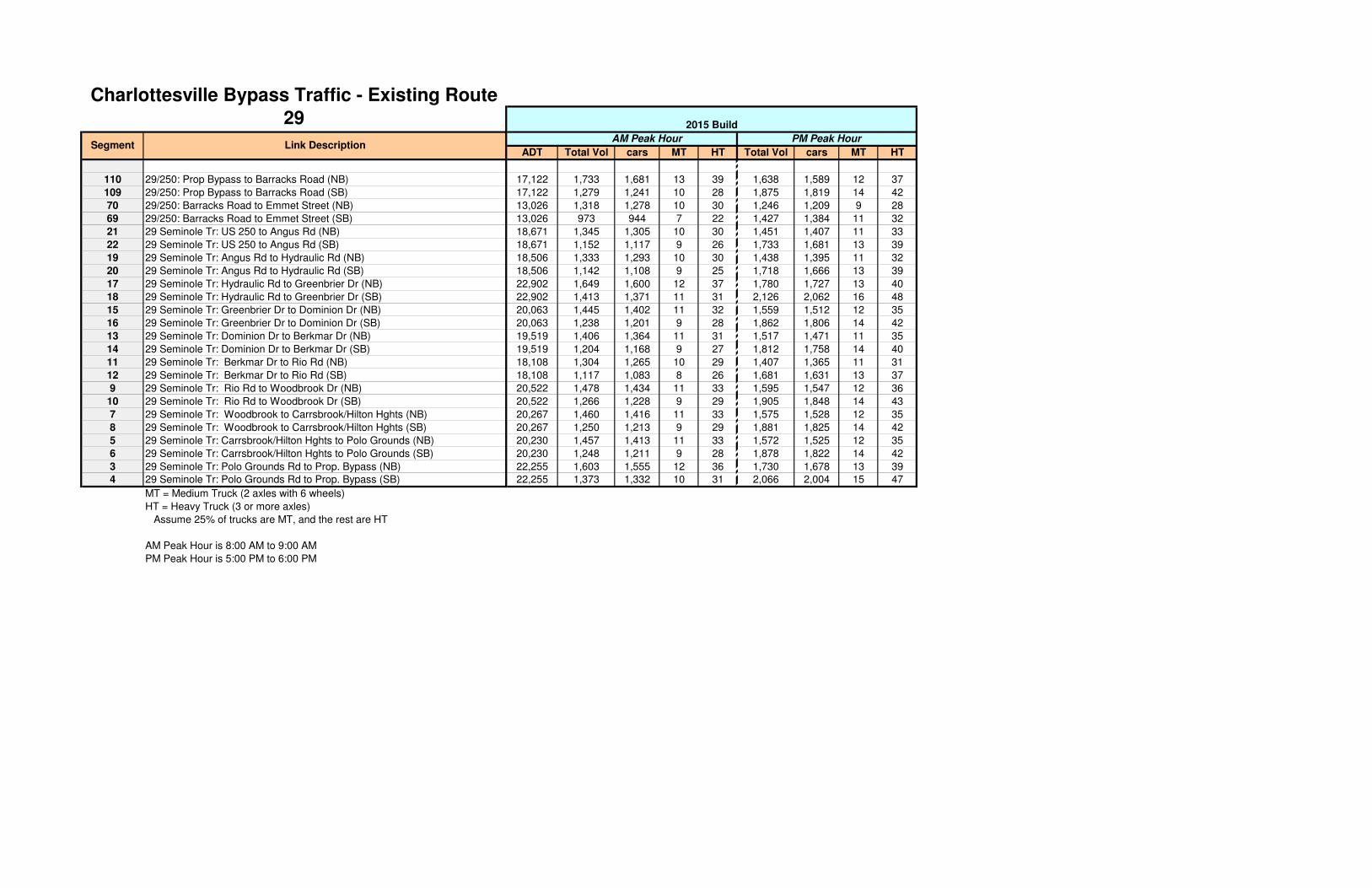
110 29/250: Prop Bypass to Barracks Road (NB)
109 29/250: Prop Bypass to Barracks Road (SB)
70 29/250: Barracks Road to Emmet Street (NB)
69 29/250: Barracks Road to Emmet Street (SB)
21 29 Seminole Tr: US 250 to Angus Rd (NB)
22 29 Seminole Tr: US 250 to Angus Rd (SB)
19 29 Seminole Tr: Angus Rd to Hydraulic Rd (NB)
20 29 Seminole Tr: Angus Rd to Hydraulic Rd (SB)
17 29 Seminole Tr: Hydraulic Rd to Greenbrier Dr (NB)
18 29 Seminole Tr: Hydraulic Rd to Greenbrier Dr (SB)
15 29 Seminole Tr: Greenbrier Dr to Dominion Dr (NB)
16 29 Seminole Tr: Greenbrier Dr to Dominion Dr (SB)
13 29 Seminole Tr: Dominion Dr to Berkmar Dr (NB)
14 29 Seminole Tr: Dominion Dr to Berkmar Dr (SB)
11 29 Seminole Tr: Berkmar Dr to Rio Rd (NB)
12 29 Seminole Tr: Berkmar Dr to Rio Rd (SB)
9 29 Seminole Tr: Rio Rd to Woodbrook Dr (NB)
10 29 Seminole Tr: Rio Rd to Woodbrook Dr (SB)
7 29 Seminole Tr: Woodbrook to Carrsbrook/Hilton Hghts (NB)
8 29 Seminole Tr: Woodbrook to Carrsbrook/Hilton Hghts (SB)
5 29 Seminole Tr: Carrsbrook/Hilton Hghts to Polo Grounds (NB)
6 29 Seminole Tr: Carrsbrook/Hilton Hghts to Polo Grounds (SB)
3 29 Seminole Tr: Polo Grounds Rd to Prop. Bypass (NB)
4 29 Seminole Tr: Polo Grounds Rd to Prop. Bypass (SB)
MT = Medium Truck (2 axles with 6 wheels)
HT = Heavy Truck (3 or more axles)
Assume 25% of trucks are MT, and the rest are HT
AM Peak Hour is 8:00 AM to 9:00 AM
PM Peak Hour is 5:00 PM to 6:00 PM
Segment Link Description
Charlottesville Bypass Traffic - Existing Route
29
ADT Total Vol cars MT HT Total Vol cars MT HT
17,122 1,733 1,681 13 39 1,638 1,589 12 37
17,122 1,279 1,241 10 28 1,875 1,819 14 42
13,026 1,318 1,278 10 30 1,246 1,209 9 28
13,026 973 944 7 22 1,427 1,384 11 32
18,671 1,345 1,305 10 30 1,451 1,407 11 33
18,671 1,152 1,117 9 26 1,733 1,681 13 39
18,506 1,333 1,293 10 30 1,438 1,395 11 32
18,506 1,142 1,108 9 25 1,718 1,666 13 39
22,902 1,649 1,600 12 37 1,780 1,727 13 40
22,902 1,413 1,371 11 31 2,126 2,062 16 48
20,063 1,445 1,402 11 32 1,559 1,512 12 35
20,063 1,238 1,201 9 28 1,862 1,806 14 42
19,519 1,406 1,364 11 31 1,517 1,471 11 35
19,519 1,204 1,168 9 27 1,812 1,758 14 40
18,108 1,304 1,265 10 29 1,407 1,365 11 31
18,108 1,117 1,083 8 26 1,681 1,631 13 37
20,522 1,478 1,434 11 33 1,595 1,547 12 36
20,522 1,266 1,228 9 29 1,905 1,848 14 43
20,267 1,460 1,416 11 33 1,575 1,528 12 35
20,267 1,250 1,213 9 29 1,881 1,825 14 42
20,230 1,457 1,413 11 33 1,572 1,525 12 35
20,230 1,248 1,211 9 28 1,878 1,822 14 42
22,255 1,603 1,555 12 36 1,730 1,678 13 39
22,255 1,373 1,332 10 31 2,066 2,004 15 47
PM Peak HourAM Peak Hour
2015 Build

110 29/250: Prop Bypass to Barracks Road (NB)
109 29/250: Prop Bypass to Barracks Road (SB)
70 29/250: Barracks Road to Emmet Street (NB)
69 29/250: Barracks Road to Emmet Street (SB)
21 29 Seminole Tr: US 250 to Angus Rd (NB)
22 29 Seminole Tr: US 250 to Angus Rd (SB)
19 29 Seminole Tr: Angus Rd to Hydraulic Rd (NB)
20 29 Seminole Tr: Angus Rd to Hydraulic Rd (SB)
17 29 Seminole Tr: Hydraulic Rd to Greenbrier Dr (NB)
18 29 Seminole Tr: Hydraulic Rd to Greenbrier Dr (SB)
15 29 Seminole Tr: Greenbrier Dr to Dominion Dr (NB)
16 29 Seminole Tr: Greenbrier Dr to Dominion Dr (SB)
13 29 Seminole Tr: Dominion Dr to Berkmar Dr (NB)
14 29 Seminole Tr: Dominion Dr to Berkmar Dr (SB)
11 29 Seminole Tr: Berkmar Dr to Rio Rd (NB)
12 29 Seminole Tr: Berkmar Dr to Rio Rd (SB)
9 29 Seminole Tr: Rio Rd to Woodbrook Dr (NB)
10 29 Seminole Tr: Rio Rd to Woodbrook Dr (SB)
7 29 Seminole Tr: Woodbrook to Carrsbrook/Hilton Hghts (NB)
8 29 Seminole Tr: Woodbrook to Carrsbrook/Hilton Hghts (SB)
5 29 Seminole Tr: Carrsbrook/Hilton Hghts to Polo Grounds (NB)
6 29 Seminole Tr: Carrsbrook/Hilton Hghts to Polo Grounds (SB)
3 29 Seminole Tr: Polo Grounds Rd to Prop. Bypass (NB)
4 29 Seminole Tr: Polo Grounds Rd to Prop. Bypass (SB)
MT = Medium Truck (2 axles with 6 wheels)
HT = Heavy Truck (3 or more axles)
Assume 25% of trucks are MT, and the rest are HT
AM Peak Hour is 8:00 AM to 9:00 AM
PM Peak Hour is 5:00 PM to 6:00 PM
Segment Link Description
Charlottesville Bypass Traffic - Existing Route
29
ADT Total Vol cars MT HT Total Vol cars MT HT
35,325 3,576 3,469 27 80 3,380 3,279 25 76
35,325 2,639 2,560 20 59 3,869 3,753 29 87
29,329 2,969 2,880 22 67 2,806 2,722 21 63
29,329 2,191 2,125 16 50 3,212 3,116 24 72
42,939 3,092 2,999 23 70 3,337 3,237 25 75
42,939 2,649 2,570 20 59 3,986 3,866 30 90
41,646 2,999 2,909 22 68 3,237 3,140 24 73
41,646 2,569 2,492 19 58 3,866 3,750 29 87
41,642 2,999 2,909 22 68 3,237 3,140 24 73
41,642 2,569 2,492 19 58 3,865 3,749 29 87
42,180 3,038 2,947 23 68 3,278 3,180 25 73
42,180 2,602 2,524 20 58 3,915 3,798 29 88
40,158 2,892 2,805 22 65 3,121 3,027 23 71
40,158 2,477 2,403 19 55 3,727 3,615 28 84
32,973 2,375 2,304 18 53 2,563 2,486 19 58
32,973 2,034 1,973 15 46 3,061 2,969 23 69
40,528 2,919 2,831 22 66 3,150 3,056 24 71
40,528 2,500 2,425 19 56 3,762 3,649 28 85
38,339 2,761 2,678 21 62 2,980 2,891 22 67
38,339 2,365 2,294 18 53 3,559 3,452 27 80
37,832 2,725 2,643 20 62 2,941 2,853 22 66
37,832 2,334 2,264 18 52 3,512 3,407 26 79
36,539 2,631 2,552 20 59 2,840 2,755 21 64
36,539 2,254 2,186 17 51 3,392 3,290 25 77
AM Peak Hour PM Peak Hour
2040 No-Build

110 29/250: Prop Bypass to Barracks Road (NB)
109 29/250: Prop Bypass to Barracks Road (SB)
70 29/250: Barracks Road to Emmet Street (NB)
69 29/250: Barracks Road to Emmet Street (SB)
21 29 Seminole Tr: US 250 to Angus Rd (NB)
22 29 Seminole Tr: US 250 to Angus Rd (SB)
19 29 Seminole Tr: Angus Rd to Hydraulic Rd (NB)
20 29 Seminole Tr: Angus Rd to Hydraulic Rd (SB)
17 29 Seminole Tr: Hydraulic Rd to Greenbrier Dr (NB)
18 29 Seminole Tr: Hydraulic Rd to Greenbrier Dr (SB)
15 29 Seminole Tr: Greenbrier Dr to Dominion Dr (NB)
16 29 Seminole Tr: Greenbrier Dr to Dominion Dr (SB)
13 29 Seminole Tr: Dominion Dr to Berkmar Dr (NB)
14 29 Seminole Tr: Dominion Dr to Berkmar Dr (SB)
11 29 Seminole Tr: Berkmar Dr to Rio Rd (NB)
12 29 Seminole Tr: Berkmar Dr to Rio Rd (SB)
9 29 Seminole Tr: Rio Rd to Woodbrook Dr (NB)
10 29 Seminole Tr: Rio Rd to Woodbrook Dr (SB)
7 29 Seminole Tr: Woodbrook to Carrsbrook/Hilton Hghts (NB)
8 29 Seminole Tr: Woodbrook to Carrsbrook/Hilton Hghts (SB)
5 29 Seminole Tr: Carrsbrook/Hilton Hghts to Polo Grounds (NB)
6 29 Seminole Tr: Carrsbrook/Hilton Hghts to Polo Grounds (SB)
3 29 Seminole Tr: Polo Grounds Rd to Prop. Bypass (NB)
4 29 Seminole Tr: Polo Grounds Rd to Prop. Bypass (SB)
MT = Medium Truck (2 axles with 6 wheels)
HT = Heavy Truck (3 or more axles)
Assume 25% of trucks are MT, and the rest are HT
AM Peak Hour is 8:00 AM to 9:00 AM
PM Peak Hour is 5:00 PM to 6:00 PM
Segment Link Description
Charlottesville Bypass Traffic - Existing Route
29
ADT Total Vol cars MT HT Total Vol cars MT HT
26,559 2,688 2,607 20 61 2,541 2,465 19 57
26,559 1,984 1,924 15 45 2,909 2,822 22 65
20,315 2,056 1,994 15 47 1,944 1,886 15 43
20,315 1,517 1,471 11 35 2,225 2,158 17 50
32,783 2,361 2,290 18 53 2,548 2,472 19 57
32,783 2,022 1,961 15 46 3,043 2,952 23 68
31,544 2,272 2,204 17 51 2,452 2,378 18 56
31,544 1,946 1,888 15 43 2,928 2,840 22 66
33,852 2,438 2,365 18 55 2,631 2,552 20 59
33,852 2,088 2,025 16 47 3,142 3,048 24 70
31,463 2,266 2,198 17 51 2,445 2,372 18 55
31,463 1,941 1,883 15 43 2,920 2,832 22 66
29,231 2,105 2,042 16 47 2,272 2,204 17 51
29,231 1,803 1,749 14 40 2,713 2,632 20 61
25,583 1,842 1,787 14 41 1,988 1,928 15 45
25,583 1,578 1,531 12 35 2,375 2,304 18 53
34,297 2,470 2,396 19 55 2,666 2,586 20 60
34,297 2,116 2,053 16 47 3,183 3,088 24 71
32,217 2,320 2,250 17 53 2,504 2,429 19 56
32,217 1,987 1,927 15 45 2,990 2,900 22 68
31,755 2,287 2,218 17 52 2,468 2,394 19 55
31,755 1,959 1,900 15 44 2,948 2,860 22 66
32,705 2,355 2,284 18 53 2,542 2,466 19 57
32,705 2,017 1,956 15 46 3,036 2,945 23 68
AM Peak Hour PM Peak Hour
2040 Build

ADT % T % of ADT Total Vol Total Truck cars MT HT % of ADT Total Vol Total Truck cars MT HT
67 Route 250 Bypass WB (btwn Hydraulic Rd & Emmet St) K8 11,500 0.02 0 857 17 840 4 13 0 1,030 21 1,009 5 16
68 Route 250 Bypass EB (btwn Hydraulic Rd & Emmet St) K7 11,500 0.02 0 1,028 21 1,007 5 16 0 957 19 938 5 14
69 Route 250 Bypass WB (btwn Emmet St & Barracks Rd) K6 19,000 0.03 0 1,419 43 1,376 11 32 0 2,081 62 2,019 16 46
70 Route 250 Bypass EB (btwn Emmet St & Barracks Rd) K5 19,000 0.03 0 1,923 58 1,865 14 44 0 1,818 55 1,763 14 41
77 L. Sandbridge Rd NB, south of 29 K9 500 3.0% 12.9% 65 2 63 0 2 6.0% 30 1 29 0 1
78 L. Sandbridge Rd SB, south of 29 K10 500 3.0% 5.1% 26 1 25 0 1 11.5% 57 2 55 0 2
109 Route 250 Bypass WB (btwn Barracks Rd & Prop Route 29 Bypass) K6 24,000 3.0% 7.5% 1,793 54 1,739 13 41 11.0% 2,629 79 2,550 20 59
110 Route 250 Bypass EB (btwn Bararcks Rd & Prop Route 29 Bypass) K5 24,000 3.0% 10.1% 2,429 73 2,356 18 55 9.6% 2,296 69 2,227 17 52
111 29 NB south of the Bypass (between Fontaine and Ivy) K5 21,000 7.0% 10.1% 2,126 149 1,977 37 112 9.6% 2,009 141 1,868 35 106
112 29 SB south of the Bypass (between Fontaine and Ivy) K6 21,000 7.0% 7.5% 1,569 110 1,459 27 83 11.0% 2,300 161 2,139 40 121
113 Ivy Rd EB (btwn Rt 250 Bypass & Alderman Rd) K5 8,000 1.0% 10.1% 810 8 802 2 6 9.6% 765 8 757 2 6
114 Ivy Rd WB (btwn Rt 250 Bypass & Alderman Rd) K6 8,000 1.0% 7.5% 598 6 592 1 5 11.0% 876 9 867 2 7
115 Ivy Rd WB (btwn Rt 846 & Golf Course Dr) K6 7,000 2.0% 7.5% 523 10 513 3 7 11.0% 767 15 752 4 11
116 Ivy Rd EB (btwn Rt 846 & Golf Course Dr) K5 7,000 2.0% 10.1% 709 14 695 4 10 9.6% 670 13 657 3 10
117 Old Ivy Rd EB (btwn Crestwood Rd & Harvest Dr) K5 2,750 1.0% 10.1% 278 3 275 1 2 9.6% 263 3 260 1 2
118 Old Ivy Rd WB (btwn Crestwood Rd & Harvest Dr) K6 2,750 1.0% 7.5% 205 2 203 1 1 11.0% 301 3 298 1 2
119 Proposed Bypass NB (South Terminus to North Terminus) K2
120 Proposed Bypass SB (North Terminus to South Terminus) K1
152 AB-AC: Off-Ramp from 29 NB to L. Sandridge Rd (diamond) K2
163 AB-AJ: 29 NB to Proposed Bypass NB (flyover) K2
153 AC-AD: On-Ramp from L. Sandridge Rd to 250 NB (diamond) K2
154 AA-AD: 250 Bypass NB (thru lanes) from 29 NB Bypass diverge to On-Ramp from L. Sandridge RdK5
157 AE-AH: 250 Bypass SB (thru lanes) from Off-Ramp to L. Sandridge Rd to 29 SB Bypass mergeK6
158 AH-AG: 250 Bypass SB (thru lanes) from 29 SB Bypass merge to On-Ramp from L. Sandridge RdK6
155 AE-AF: Off-Ramp from 250 SB to L. Sandridge Rd (diamond) K1
156 AF-AG: On-Ramp from L. Sandridge Rd to 29 SB (diamond) K1
164 AI-AH: Proposed Bypass SB to 29 SB (flyover) K1
151 AA-AB: 250 NB to Split K2
159 AC-AF: L. Sandridge Rd NB, between Ramps K2
160 AF-AC: L. Sandridge Rd SB, between Ramps K1
161 AF-AJ: L. Sandridge Rd NB ramp to Proposed Bypass NB K2
162 AI-AF: Proposed Bypass SB ramp to L. Sandridge Rd SB K1
109 Route 250 SB/WB Mainline (btwn Ivy Rd & Barracks Rd) - Ex & NB K6 24,000 3.0% 7.5% 1,793 54 1,739 13 41 11.0% 2,629 79 2,550 20 59
151 Route 250 SB/WB Mainline (btwn Ivy Rd & 29 Bypass) - Build K2
110 Route 250 NB/EB Mainline (btwn Ivy Rd & L. Sandridge Rd) - Ex & NB K5 24,000 3.0% 10.1% 2,429 73 2,356 18 55 9.6% 2,296 69 2,227 17 52
110 Route 250 NB/EB Mainline (btwn L. Sandridge Rd & Barracks Rd) - Ex & NB K5 24,000 3.0% 10.1% 2,429 73 2,356 18 55 9.6% 2,296 69 2,227 17 52
158 Route 250 NB/EB Mainline (btwn Ivy Rd & 29 Bypass) - Build K6
191 Route 250 SB Off-Ramp (loop) to Ivy Rd K6 6,315 1.0% 7.5% 472 5 467 1 4 11.0% 692 7 685 2 5
192 Route 250 SB On-Ramp from Ivy Rd K6 3,353 1.0% 7.5% 250 3 248 1 2 11.0% 367 4 363 1 3
193 Route 250 NB Off-Ramp to Ivy Rd K5 3,353 1.0% 10.1% 339 3 336 1 2 9.6% 321 3 318 1 2
194 Route 250 NB On-Ramp (loop) from Ivy Rd K5 6,314 1.0% 10.1% 639 6 633 2 4 9.6% 604 6 598 2 4
MT = Medium Truck (2 axles with 6 wheels)
HT = Heavy Truck (3 or more axles)
Assume 25% of trucks are MT, and the rest are HT
AM Peak Hour is 8:00 AM to 9:00 AM
PM Peak Hour is 5:00 PM to 6:00 PM
Blue Text indicates segments added (2012-07-11)
SegmentDiurnal
Curve
Charlottesville Bypass Traffic - Southern Terminus
Area2011 Existing AM Peak Hour PM Peak Hour
Link Description

67 Route 250 Bypass WB (btwn Hydraulic Rd & Emmet St)
68 Route 250 Bypass EB (btwn Hydraulic Rd & Emmet St)
69 Route 250 Bypass WB (btwn Emmet St & Barracks Rd)
70 Route 250 Bypass EB (btwn Emmet St & Barracks Rd)
77 L. Sandbridge Rd NB, south of 29
78 L. Sandbridge Rd SB, south of 29
109 Route 250 Bypass WB (btwn Barracks Rd & Prop Route 29 Bypass)
110 Route 250 Bypass EB (btwn Bararcks Rd & Prop Route 29 Bypass)
111 29 NB south of the Bypass (between Fontaine and Ivy)
112 29 SB south of the Bypass (between Fontaine and Ivy)
113 Ivy Rd EB (btwn Rt 250 Bypass & Alderman Rd)
114 Ivy Rd WB (btwn Rt 250 Bypass & Alderman Rd)
115 Ivy Rd WB (btwn Rt 846 & Golf Course Dr)
116 Ivy Rd EB (btwn Rt 846 & Golf Course Dr)
117 Old Ivy Rd EB (btwn Crestwood Rd & Harvest Dr)
118 Old Ivy Rd WB (btwn Crestwood Rd & Harvest Dr)
119 Proposed Bypass NB (South Terminus to North Terminus)
120 Proposed Bypass SB (North Terminus to South Terminus)
152 AB-AC: Off-Ramp from 29 NB to L. Sandridge Rd (diamond)
163 AB-AJ: 29 NB to Proposed Bypass NB (flyover)
153 AC-AD: On-Ramp from L. Sandridge Rd to 250 NB (diamond)
154 AA-AD: 250 Bypass NB (thru lanes) from 29 NB Bypass diverge to On-Ramp from L. Sandridge Rd
157 AE-AH: 250 Bypass SB (thru lanes) from Off-Ramp to L. Sandridge Rd to 29 SB Bypass merge
158 AH-AG: 250 Bypass SB (thru lanes) from 29 SB Bypass merge to On-Ramp from L. Sandridge Rd
155 AE-AF: Off-Ramp from 250 SB to L. Sandridge Rd (diamond)
156 AF-AG: On-Ramp from L. Sandridge Rd to 29 SB (diamond)
164 AI-AH: Proposed Bypass SB to 29 SB (flyover)
151 AA-AB: 250 NB to Split
159 AC-AF: L. Sandridge Rd NB, between Ramps
160 AF-AC: L. Sandridge Rd SB, between Ramps
161 AF-AJ: L. Sandridge Rd NB ramp to Proposed Bypass NB
162 AI-AF: Proposed Bypass SB ramp to L. Sandridge Rd SB
109 Route 250 SB/WB Mainline (btwn Ivy Rd & Barracks Rd) - Ex & NB
151 Route 250 SB/WB Mainline (btwn Ivy Rd & 29 Bypass) - Build
110 Route 250 NB/EB Mainline (btwn Ivy Rd & L. Sandridge Rd) - Ex & NB
110 Route 250 NB/EB Mainline (btwn L. Sandridge Rd & Barracks Rd) - Ex & NB
158 Route 250 NB/EB Mainline (btwn Ivy Rd & 29 Bypass) - Build
191 Route 250 SB Off-Ramp (loop) to Ivy Rd
192 Route 250 SB On-Ramp from Ivy Rd
193 Route 250 NB Off-Ramp to Ivy Rd
194 Route 250 NB On-Ramp (loop) from Ivy Rd
MT = Medium Truck (2 axles with 6 wheels)
HT = Heavy Truck (3 or more axles)
Assume 25% of trucks are MT, and the rest are HT
AM Peak Hour is 8:00 AM to 9:00 AM
PM Peak Hour is 5:00 PM to 6:00 PM
Blue Text indicates segments added (2012-07-11)
Segment
Charlottesville Bypass Traffic - Southern Terminus
Area
Link DescriptionADT % T % of ADT Total Vol Total Truck cars MT HT % of ADT Total Vol Total Truck cars MT HT
12,314 0.02 0 918 18 900 5 13 0 1,103 22 1,081 6 16
12,314 0.02 0 1,101 22 1,079 6 16 0 1,024 20 1,004 5 15
20,717 0.03 0 1,547 46 1,501 12 34 0 2,269 68 2,201 17 51
20,717 0.03 0 2,097 63 2,034 16 47 0 1,982 59 1,923 15 44
503 3.0% 12.9% 65 2 63 0 2 6.0% 30 1 29 0 1
503 3.0% 5.1% 26 1 25 0 1 11.5% 58 2 56 0 2
25,888 3.0% 7.5% 1,934 58 1,876 15 43 11.0% 2,835 85 2,750 21 64
25,888 3.0% 10.1% 2,620 79 2,541 20 59 9.6% 2,477 74 2,403 19 55
23,115 7.0% 10.1% 2,340 164 2,176 41 123 9.6% 2,212 155 2,057 39 116
23,115 7.0% 7.5% 1,727 121 1,606 30 91 11.0% 2,532 177 2,355 44 133
7,711 1.0% 10.1% 780 8 772 2 6 9.6% 738 7 731 2 5
7,711 1.0% 7.5% 576 6 570 1 5 11.0% 845 8 837 2 6
7,518 2.0% 7.5% 562 11 551 3 8 11.0% 823 16 807 4 12
7,518 2.0% 10.1% 761 15 746 4 11 9.6% 719 14 705 4 10
2,773 1.0% 10.1% 281 3 278 1 2 9.6% 265 3 262 1 2
2,773 1.0% 7.5% 207 2 205 1 1 11.0% 304 3 301 1 2
25,888 3.0% 7.5% 1,934 58 1,876 15 43 11.0% 2,835 85 2,750 21 64
25,888 3.0% 10.1% 2,620 79 2,541 20 59 9.6% 2,477 74 2,403 19 55
25,888 3.0% 10.1% 2,620 79 2,541 20 59 9.6% 2,477 74 2,403 19 55
6,341 1.0% 7.5% 474 5 469 1 4 11.0% 695 7 688 2 5
3,612 1.0% 7.5% 270 3 267 1 2 11.0% 396 4 392 1 3
3,612 1.0% 10.1% 366 4 362 1 3 9.6% 346 3 343 1 2
6,341 1.0% 10.1% 642 6 636 2 4 9.6% 607 6 601 2 4
2015 No-Build AM Peak Hour PM Peak Hour
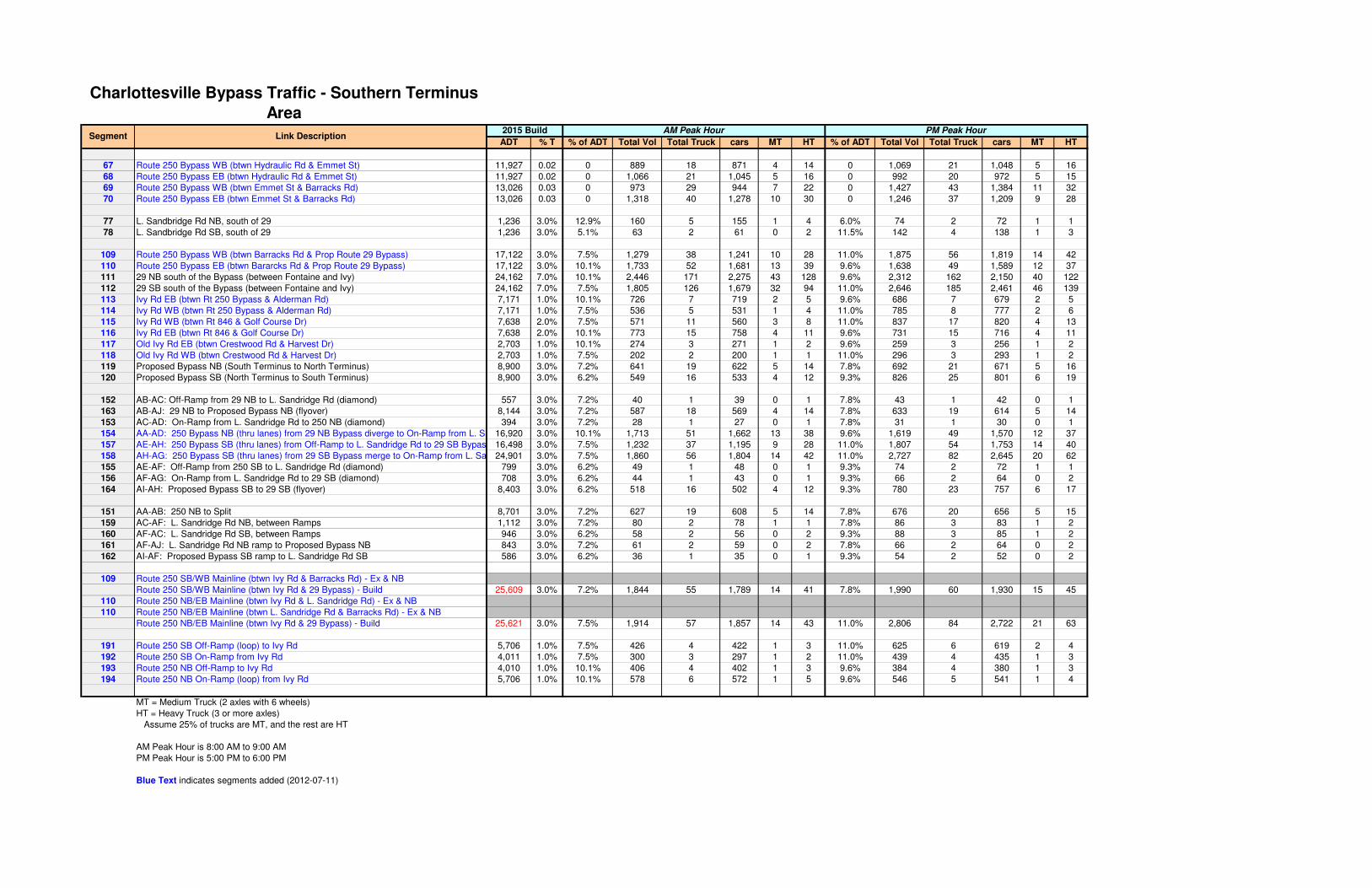
67 Route 250 Bypass WB (btwn Hydraulic Rd & Emmet St)
68 Route 250 Bypass EB (btwn Hydraulic Rd & Emmet St)
69 Route 250 Bypass WB (btwn Emmet St & Barracks Rd)
70 Route 250 Bypass EB (btwn Emmet St & Barracks Rd)
77 L. Sandbridge Rd NB, south of 29
78 L. Sandbridge Rd SB, south of 29
109 Route 250 Bypass WB (btwn Barracks Rd & Prop Route 29 Bypass)
110 Route 250 Bypass EB (btwn Bararcks Rd & Prop Route 29 Bypass)
111 29 NB south of the Bypass (between Fontaine and Ivy)
112 29 SB south of the Bypass (between Fontaine and Ivy)
113 Ivy Rd EB (btwn Rt 250 Bypass & Alderman Rd)
114 Ivy Rd WB (btwn Rt 250 Bypass & Alderman Rd)
115 Ivy Rd WB (btwn Rt 846 & Golf Course Dr)
116 Ivy Rd EB (btwn Rt 846 & Golf Course Dr)
117 Old Ivy Rd EB (btwn Crestwood Rd & Harvest Dr)
118 Old Ivy Rd WB (btwn Crestwood Rd & Harvest Dr)
119 Proposed Bypass NB (South Terminus to North Terminus)
120 Proposed Bypass SB (North Terminus to South Terminus)
152 AB-AC: Off-Ramp from 29 NB to L. Sandridge Rd (diamond)
163 AB-AJ: 29 NB to Proposed Bypass NB (flyover)
153 AC-AD: On-Ramp from L. Sandridge Rd to 250 NB (diamond)
154 AA-AD: 250 Bypass NB (thru lanes) from 29 NB Bypass diverge to On-Ramp from L. Sandridge Rd
157 AE-AH: 250 Bypass SB (thru lanes) from Off-Ramp to L. Sandridge Rd to 29 SB Bypass merge
158 AH-AG: 250 Bypass SB (thru lanes) from 29 SB Bypass merge to On-Ramp from L. Sandridge Rd
155 AE-AF: Off-Ramp from 250 SB to L. Sandridge Rd (diamond)
156 AF-AG: On-Ramp from L. Sandridge Rd to 29 SB (diamond)
164 AI-AH: Proposed Bypass SB to 29 SB (flyover)
151 AA-AB: 250 NB to Split
159 AC-AF: L. Sandridge Rd NB, between Ramps
160 AF-AC: L. Sandridge Rd SB, between Ramps
161 AF-AJ: L. Sandridge Rd NB ramp to Proposed Bypass NB
162 AI-AF: Proposed Bypass SB ramp to L. Sandridge Rd SB
109 Route 250 SB/WB Mainline (btwn Ivy Rd & Barracks Rd) - Ex & NB
151 Route 250 SB/WB Mainline (btwn Ivy Rd & 29 Bypass) - Build
110 Route 250 NB/EB Mainline (btwn Ivy Rd & L. Sandridge Rd) - Ex & NB
110 Route 250 NB/EB Mainline (btwn L. Sandridge Rd & Barracks Rd) - Ex & NB
158 Route 250 NB/EB Mainline (btwn Ivy Rd & 29 Bypass) - Build
191 Route 250 SB Off-Ramp (loop) to Ivy Rd
192 Route 250 SB On-Ramp from Ivy Rd
193 Route 250 NB Off-Ramp to Ivy Rd
194 Route 250 NB On-Ramp (loop) from Ivy Rd
MT = Medium Truck (2 axles with 6 wheels)
HT = Heavy Truck (3 or more axles)
Assume 25% of trucks are MT, and the rest are HT
AM Peak Hour is 8:00 AM to 9:00 AM
PM Peak Hour is 5:00 PM to 6:00 PM
Blue Text indicates segments added (2012-07-11)
Segment
Charlottesville Bypass Traffic - Southern Terminus
Area
Link DescriptionADT % T % of ADT Total Vol Total Truck cars MT HT % of ADT Total Vol Total Truck cars MT HT
11,927 0.02 0 889 18 871 4 14 0 1,069 21 1,048 5 16
11,927 0.02 0 1,066 21 1,045 5 16 0 992 20 972 5 15
13,026 0.03 0 973 29 944 7 22 0 1,427 43 1,384 11 32
13,026 0.03 0 1,318 40 1,278 10 30 0 1,246 37 1,209 9 28
1,236 3.0% 12.9% 160 5 155 1 4 6.0% 74 2 72 1 1
1,236 3.0% 5.1% 63 2 61 0 2 11.5% 142 4 138 1 3
17,122 3.0% 7.5% 1,279 38 1,241 10 28 11.0% 1,875 56 1,819 14 42
17,122 3.0% 10.1% 1,733 52 1,681 13 39 9.6% 1,638 49 1,589 12 37
24,162 7.0% 10.1% 2,446 171 2,275 43 128 9.6% 2,312 162 2,150 40 122
24,162 7.0% 7.5% 1,805 126 1,679 32 94 11.0% 2,646 185 2,461 46 139
7,171 1.0% 10.1% 726 7 719 2 5 9.6% 686 7 679 2 5
7,171 1.0% 7.5% 536 5 531 1 4 11.0% 785 8 777 2 6
7,638 2.0% 7.5% 571 11 560 3 8 11.0% 837 17 820 4 13
7,638 2.0% 10.1% 773 15 758 4 11 9.6% 731 15 716 4 11
2,703 1.0% 10.1% 274 3 271 1 2 9.6% 259 3 256 1 2
2,703 1.0% 7.5% 202 2 200 1 1 11.0% 296 3 293 1 2
8,900 3.0% 7.2% 641 19 622 5 14 7.8% 692 21 671 5 16
8,900 3.0% 6.2% 549 16 533 4 12 9.3% 826 25 801 6 19
557 3.0% 7.2% 40 1 39 0 1 7.8% 43 1 42 0 1
8,144 3.0% 7.2% 587 18 569 4 14 7.8% 633 19 614 5 14
394 3.0% 7.2% 28 1 27 0 1 7.8% 31 1 30 0 1
16,920 3.0% 10.1% 1,713 51 1,662 13 38 9.6% 1,619 49 1,570 12 37
16,498 3.0% 7.5% 1,232 37 1,195 9 28 11.0% 1,807 54 1,753 14 40
24,901 3.0% 7.5% 1,860 56 1,804 14 42 11.0% 2,727 82 2,645 20 62
799 3.0% 6.2% 49 1 48 0 1 9.3% 74 2 72 1 1
708 3.0% 6.2% 44 1 43 0 1 9.3% 66 2 64 0 2
8,403 3.0% 6.2% 518 16 502 4 12 9.3% 780 23 757 6 17
8,701 3.0% 7.2% 627 19 608 5 14 7.8% 676 20 656 5 15
1,112 3.0% 7.2% 80 2 78 1 1 7.8% 86 3 83 1 2
946 3.0% 6.2% 58 2 56 0 2 9.3% 88 3 85 1 2
843 3.0% 7.2% 61 2 59 0 2 7.8% 66 2 64 0 2
586 3.0% 6.2% 36 1 35 0 1 9.3% 54 2 52 0 2
25,609 3.0% 7.2% 1,844 55 1,789 14 41 7.8% 1,990 60 1,930 15 45
25,621 3.0% 7.5% 1,914 57 1,857 14 43 11.0% 2,806 84 2,722 21 63
5,706 1.0% 7.5% 426 4 422 1 3 11.0% 625 6 619 2 4
4,011 1.0% 7.5% 300 3 297 1 2 11.0% 439 4 435 1 3
4,010 1.0% 10.1% 406 4 402 1 3 9.6% 384 4 380 1 3
5,706 1.0% 10.1% 578 6 572 1 5 9.6% 546 5 541 1 4
2015 Build AM Peak Hour PM Peak Hour

67 Route 250 Bypass WB (btwn Hydraulic Rd & Emmet St)
68 Route 250 Bypass EB (btwn Hydraulic Rd & Emmet St)
69 Route 250 Bypass WB (btwn Emmet St & Barracks Rd)
70 Route 250 Bypass EB (btwn Emmet St & Barracks Rd)
77 L. Sandbridge Rd NB, south of 29
78 L. Sandbridge Rd SB, south of 29
109 Route 250 Bypass WB (btwn Barracks Rd & Prop Route 29 Bypass)
110 Route 250 Bypass EB (btwn Bararcks Rd & Prop Route 29 Bypass)
111 29 NB south of the Bypass (between Fontaine and Ivy)
112 29 SB south of the Bypass (between Fontaine and Ivy)
113 Ivy Rd EB (btwn Rt 250 Bypass & Alderman Rd)
114 Ivy Rd WB (btwn Rt 250 Bypass & Alderman Rd)
115 Ivy Rd WB (btwn Rt 846 & Golf Course Dr)
116 Ivy Rd EB (btwn Rt 846 & Golf Course Dr)
117 Old Ivy Rd EB (btwn Crestwood Rd & Harvest Dr)
118 Old Ivy Rd WB (btwn Crestwood Rd & Harvest Dr)
119 Proposed Bypass NB (South Terminus to North Terminus)
120 Proposed Bypass SB (North Terminus to South Terminus)
152 AB-AC: Off-Ramp from 29 NB to L. Sandridge Rd (diamond)
163 AB-AJ: 29 NB to Proposed Bypass NB (flyover)
153 AC-AD: On-Ramp from L. Sandridge Rd to 250 NB (diamond)
154 AA-AD: 250 Bypass NB (thru lanes) from 29 NB Bypass diverge to On-Ramp from L. Sandridge Rd
157 AE-AH: 250 Bypass SB (thru lanes) from Off-Ramp to L. Sandridge Rd to 29 SB Bypass merge
158 AH-AG: 250 Bypass SB (thru lanes) from 29 SB Bypass merge to On-Ramp from L. Sandridge Rd
155 AE-AF: Off-Ramp from 250 SB to L. Sandridge Rd (diamond)
156 AF-AG: On-Ramp from L. Sandridge Rd to 29 SB (diamond)
164 AI-AH: Proposed Bypass SB to 29 SB (flyover)
151 AA-AB: 250 NB to Split
159 AC-AF: L. Sandridge Rd NB, between Ramps
160 AF-AC: L. Sandridge Rd SB, between Ramps
161 AF-AJ: L. Sandridge Rd NB ramp to Proposed Bypass NB
162 AI-AF: Proposed Bypass SB ramp to L. Sandridge Rd SB
109 Route 250 SB/WB Mainline (btwn Ivy Rd & Barracks Rd) - Ex & NB
151 Route 250 SB/WB Mainline (btwn Ivy Rd & 29 Bypass) - Build
110 Route 250 NB/EB Mainline (btwn Ivy Rd & L. Sandridge Rd) - Ex & NB
110 Route 250 NB/EB Mainline (btwn L. Sandridge Rd & Barracks Rd) - Ex & NB
158 Route 250 NB/EB Mainline (btwn Ivy Rd & 29 Bypass) - Build
191 Route 250 SB Off-Ramp (loop) to Ivy Rd
192 Route 250 SB On-Ramp from Ivy Rd
193 Route 250 NB Off-Ramp to Ivy Rd
194 Route 250 NB On-Ramp (loop) from Ivy Rd
MT = Medium Truck (2 axles with 6 wheels)
HT = Heavy Truck (3 or more axles)
Assume 25% of trucks are MT, and the rest are HT
AM Peak Hour is 8:00 AM to 9:00 AM
PM Peak Hour is 5:00 PM to 6:00 PM
Blue Text indicates segments added (2012-07-11)
Segment
Charlottesville Bypass Traffic - Southern Terminus
Area
Link DescriptionADT % T % of ADT Total Vol Total Truck cars MT HT % of ADT Total Vol Total Truck cars MT HT
16,364 0.02 0 1,220 24 1,196 6 18 0 1,466 29 1,437 7 22
16,364 0.02 0 1,463 29 1,434 7 22 0 1,361 27 1,334 7 20
29,329 0.03 0 2,191 66 2,125 16 50 0 3,212 96 3,116 24 72
29,329 0.03 0 2,969 89 2,880 22 67 0 2,806 84 2,722 21 63
3,028 3.0% 12.9% 391 12 379 3 9 6.0% 181 5 176 1 4
3,028 3.0% 5.1% 155 5 150 1 4 11.5% 348 10 338 3 7
35,325 3.0% 7.5% 2,639 79 2,560 20 59 11.0% 3,869 116 3,753 29 87
35,325 3.0% 10.1% 3,576 107 3,469 27 80 9.6% 3,380 101 3,279 25 76
33,702 7.0% 10.1% 3,411 239 3,172 60 179 9.6% 3,225 226 2,999 56 170
33,702 7.0% 7.5% 2,517 176 2,341 44 132 11.0% 3,691 258 3,433 65 193
6,261 1.0% 10.1% 634 6 628 2 4 9.6% 599 6 593 1 5
6,261 1.0% 7.5% 468 5 463 1 4 11.0% 686 7 679 2 5
10,118 2.0% 7.5% 756 15 741 4 11 11.0% 1,108 22 1,086 6 16
10,118 2.0% 10.1% 1,024 20 1,004 5 15 9.6% 968 19 949 5 14
2,860 1.0% 10.1% 289 3 286 1 2 9.6% 274 3 271 1 2
2,860 1.0% 7.5% 214 2 212 1 1 11.0% 313 3 310 1 2
35,325 3.0% 7.5% 2,639 79 2,560 20 59 11.0% 3,869 116 3,753 29 87
35,325 3.0% 10.1% 3,576 107 3,469 27 80 9.6% 3,380 101 3,279 25 76
35,325 3.0% 10.1% 3,576 107 3,469 27 80 9.6% 3,380 101 3,279 25 76
6,631 1.0% 7.5% 495 5 490 1 4 11.0% 726 7 719 2 5
5,058 1.0% 7.5% 378 4 374 1 3 11.0% 554 6 548 1 5
5,057 1.0% 10.1% 512 5 507 1 4 9.6% 484 5 479 1 4
6,631 1.0% 10.1% 671 7 664 2 5 9.6% 634 6 628 2 4
2040 No-Build AM Peak Hour PM Peak Hour

67 Route 250 Bypass WB (btwn Hydraulic Rd & Emmet St)
68 Route 250 Bypass EB (btwn Hydraulic Rd & Emmet St)
69 Route 250 Bypass WB (btwn Emmet St & Barracks Rd)
70 Route 250 Bypass EB (btwn Emmet St & Barracks Rd)
77 L. Sandbridge Rd NB, south of 29
78 L. Sandbridge Rd SB, south of 29
109 Route 250 Bypass WB (btwn Barracks Rd & Prop Route 29 Bypass)
110 Route 250 Bypass EB (btwn Bararcks Rd & Prop Route 29 Bypass)
111 29 NB south of the Bypass (between Fontaine and Ivy)
112 29 SB south of the Bypass (between Fontaine and Ivy)
113 Ivy Rd EB (btwn Rt 250 Bypass & Alderman Rd)
114 Ivy Rd WB (btwn Rt 250 Bypass & Alderman Rd)
115 Ivy Rd WB (btwn Rt 846 & Golf Course Dr)
116 Ivy Rd EB (btwn Rt 846 & Golf Course Dr)
117 Old Ivy Rd EB (btwn Crestwood Rd & Harvest Dr)
118 Old Ivy Rd WB (btwn Crestwood Rd & Harvest Dr)
119 Proposed Bypass NB (South Terminus to North Terminus)
120 Proposed Bypass SB (North Terminus to South Terminus)
152 AB-AC: Off-Ramp from 29 NB to L. Sandridge Rd (diamond)
163 AB-AJ: 29 NB to Proposed Bypass NB (flyover)
153 AC-AD: On-Ramp from L. Sandridge Rd to 250 NB (diamond)
154 AA-AD: 250 Bypass NB (thru lanes) from 29 NB Bypass diverge to On-Ramp from L. Sandridge Rd
157 AE-AH: 250 Bypass SB (thru lanes) from Off-Ramp to L. Sandridge Rd to 29 SB Bypass merge
158 AH-AG: 250 Bypass SB (thru lanes) from 29 SB Bypass merge to On-Ramp from L. Sandridge Rd
155 AE-AF: Off-Ramp from 250 SB to L. Sandridge Rd (diamond)
156 AF-AG: On-Ramp from L. Sandridge Rd to 29 SB (diamond)
164 AI-AH: Proposed Bypass SB to 29 SB (flyover)
151 AA-AB: 250 NB to Split
159 AC-AF: L. Sandridge Rd NB, between Ramps
160 AF-AC: L. Sandridge Rd SB, between Ramps
161 AF-AJ: L. Sandridge Rd NB ramp to Proposed Bypass NB
162 AI-AF: Proposed Bypass SB ramp to L. Sandridge Rd SB
109 Route 250 SB/WB Mainline (btwn Ivy Rd & Barracks Rd) - Ex & NB
151 Route 250 SB/WB Mainline (btwn Ivy Rd & 29 Bypass) - Build
110 Route 250 NB/EB Mainline (btwn Ivy Rd & L. Sandridge Rd) - Ex & NB
110 Route 250 NB/EB Mainline (btwn L. Sandridge Rd & Barracks Rd) - Ex & NB
158 Route 250 NB/EB Mainline (btwn Ivy Rd & 29 Bypass) - Build
191 Route 250 SB Off-Ramp (loop) to Ivy Rd
192 Route 250 SB On-Ramp from Ivy Rd
193 Route 250 NB Off-Ramp to Ivy Rd
194 Route 250 NB On-Ramp (loop) from Ivy Rd
MT = Medium Truck (2 axles with 6 wheels)
HT = Heavy Truck (3 or more axles)
Assume 25% of trucks are MT, and the rest are HT
AM Peak Hour is 8:00 AM to 9:00 AM
PM Peak Hour is 5:00 PM to 6:00 PM
Blue Text indicates segments added (2012-07-11)
Segment
Charlottesville Bypass Traffic - Southern Terminus
Area
Link DescriptionADT % T % of ADT Total Vol Total Truck cars MT HT % of ADT Total Vol cars MT HT
15,977 0.02 0 1,191 24 1,167 6 18 0 1,431 1,402 7 22
15,977 0.02 0 1,428 29 1,399 7 22 0 1,329 1,302 7 20
20,315 0.03 0 1,517 46 1,471 11 35 0 2,225 2,158 17 50
20,315 0.03 0 2,056 62 1,994 15 47 0 1,944 1,886 15 43
3,761 3.0% 12.9% 486 15 471 4 11 6.0% 224 217 2 5
3,761 3.0% 5.1% 193 6 187 1 5 11.5% 432 419 3 10
26,559 3.0% 7.5% 1,984 60 1,924 15 45 11.0% 2,909 2,822 22 65
26,559 3.0% 10.1% 2,688 81 2,607 20 61 9.6% 2,541 2,465 19 57
34,750 7.0% 10.1% 3,517 246 3,271 62 184 9.6% 3,325 3,092 58 175
34,750 7.0% 7.5% 2,596 182 2,414 45 137 11.0% 3,806 3,540 67 199
5,721 1.0% 10.1% 579 6 573 1 5 9.6% 547 542 1 4
5,721 1.0% 7.5% 427 4 423 1 3 11.0% 627 621 2 4
10,238 2.0% 7.5% 765 15 750 4 11 11.0% 1,121 1,099 6 16
10,238 2.0% 10.1% 1,036 21 1,015 5 16 9.6% 980 960 5 15
2,790 1.0% 10.1% 282 3 279 1 2 9.6% 267 264 1 2
2,790 1.0% 7.5% 208 2 206 1 1 11.0% 306 303 1 2
13,899 3.0% 7.2% 1,001 30 971 8 22 7.8% 1,080 1,048 8 24
13,899 3.0% 6.2% 857 26 831 6 20 9.3% 1,290 1,251 10 29
762 3.0% 7.2% 55 2 53 0 2 7.8% 59 57 0 2
10,135 3.0% 7.2% 730 22 708 5 17 7.8% 788 764 6 18
1,930 3.0% 7.2% 139 4 135 1 3 7.8% 150 146 1 4
24,537 3.0% 10.1% 2,484 75 2,409 19 56 9.6% 2,348 2,278 18 52
23,047 3.0% 7.5% 1,721 52 1,669 13 39 11.0% 2,524 2,448 19 57
34,301 3.0% 7.5% 2,562 77 2,485 19 58 11.0% 3,757 3,644 28 85
3,435 3.0% 6.2% 212 6 206 2 4 9.3% 319 309 2 8
1,144 3.0% 6.2% 71 2 69 1 1 9.3% 106 103 1 2
11,254 3.0% 6.2% 694 21 673 5 16 9.3% 1,045 1,014 8 23
10,897 3.0% 7.2% 785 24 761 6 18 7.8% 847 822 6 19
3,066 3.0% 7.2% 221 7 214 2 5 7.8% 238 231 2 5
4,238 3.0% 6.2% 261 8 253 2 6 9.3% 393 381 3 9
3,728 3.0% 7.2% 268 8 260 2 6 7.8% 290 281 2 7
2,609 3.0% 6.2% 161 5 156 1 4 9.3% 242 235 2 5
35,445 3.0% 7.2% 2,553 77 2,476 19 58 7.8% 2,755 2,672 21 62
35,434 3.0% 7.5% 2,647 79 2,568 20 59 11.0% 3,881 3,765 29 87
6,073 1.0% 7.5% 454 5 449 1 4 11.0% 665 658 2 5
5,516 1.0% 7.5% 412 4 408 1 3 11.0% 604 598 2 4
5,516 1.0% 10.1% 558 6 552 1 5 9.6% 528 523 1 4
6,073 1.0% 10.1% 615 6 609 2 4 9.6% 581 575 1 5
2040 Build AM Peak Hour PM Peak Hour

Appendix E
HB 2577 DOCUMENTATION

DEPARTMENT OF TRANSPORTATION 1401 EAST BROAD STREET
RICHMOND, VIRGINIA 23219-2000 Gregory A. Whirley Acting Commissioner
VirginiaDOT.org
WE KEEP VIRGINIA MOVING
August 1, 2012
MEMORANDUM
TO: Harold Jones, Design Manager
FROM: Angel Deem, Location Studies Program Manager
SUBJECT: Route 29 Bypass; Albemarle County; UPC 102419
The 2009 General Assembly passed Chapter 120 (HB 2577), which amends the Code of Virginia
by adding in Article 15 of Chapter 1 of Title 33.1 a section numbered 33.1-223.2:21, relating to
highway noise abatement.
House Bill 2577 States: Requires that whenever the CTB or the Department plan for or
undertake any highway construction or improvement project and such project includes or may
include the requirement for the mitigation of traffic noise impacts, consideration should be given
to the use of noise reducing design and low noise pavement materials and techniques in lieu of
construction of noise walls or sound barriers. Landscaping in such a design would be utilized to
act as a visual screen if visual screening is required.
In an effort to honor the intent of HB 2577 we are asking for your input (per Chapter VI of
Materials Division’s Manual of Instruction and Section 2B-3 Determination of Roadway Design
of the VDOT Road Design manual (pages 2B-5 and 2B-6)). As part of the Noise Technical
Report and technical files, we are seeking your professional opinion by providing comments for
the project noted above. Please distribute this memorandum to the appropriate District staff and
combine all responses into one response.
Should you have any questions, please contact me at (804) 371-6768. Thank you for your time
and consideration regarding this request.
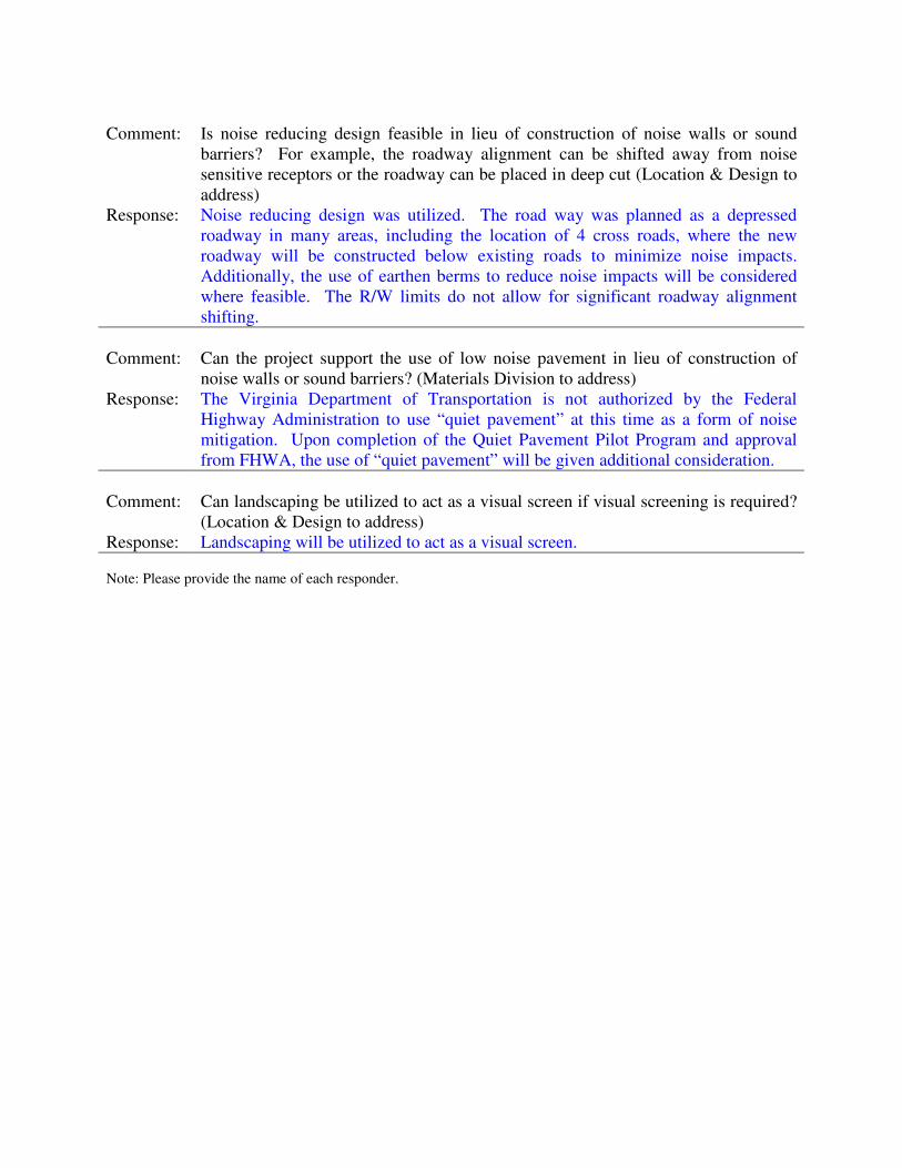
Comment: Is noise reducing design feasible in lieu of construction of noise walls or sound
barriers? For example, the roadway alignment can be shifted away from noise
sensitive receptors or the roadway can be placed in deep cut (Location & Design to
address)
Response: Noise reducing design was utilized. The road way was planned as a depressed
roadway in many areas, including the location of 4 cross roads, where the new
roadway will be constructed below existing roads to minimize noise impacts.
Additionally, the use of earthen berms to reduce noise impacts will be considered
where feasible. The R/W limits do not allow for significant roadway alignment
shifting.
Comment: Can the project support the use of low noise pavement in lieu of construction of
noise walls or sound barriers? (Materials Division to address)
Response: The Virginia Department of Transportation is not authorized by the Federal
Highway Administration to use “quiet pavement” at this time as a form of noise
mitigation. Upon completion of the Quiet Pavement Pilot Program and approval
from FHWA, the use of “quiet pavement” will be given additional consideration.
Comment: Can landscaping be utilized to act as a visual screen if visual screening is required?
(Location & Design to address)
Response: Landscaping will be utilized to act as a visual screen.
Note: Please provide the name of each responder.

Appendix F
WARRANTED, FEASIBLE & REASONABLE WORKSHEETS

Date:
Project No. and UPC:
County:
District:
Barrier System ID:
Community Name and/or CNE#
Noise Abatement Category(s)
Design phase:
Warranted
1 Community Documentation (if applicable)
a.
NA
b.
NA
2 Criteria requiring consideration of noise abatement
b. Project causes a substantial noise increase of 10 dB(A) or more? Yes
Feasibility
1 Impacted receptor units
a. Number of impacted receptor units: 7
b. Number of impacted receptor units receiving 5 dB(A) or more insertion loss (IL): 3
c. Percentage of impacted receptor units receiving 5 dB(A) or more IL 43%
d. Is the percentage 50 or greater? No
2No
3 Will placement of the noise barrier restrict access to vehicular or pedestrian travel? No
4 Will placement of the noise barrier conflict with existing utility locations? No
Project causes design year noise levels to approach or exceed the Noise Abatement
Criteria? Yes
a.
c.
NA
CNE B
B
VDOT Highway Traffic Noise Abatement
Warranted, Feasible, and Reasonable Worksheet
6-Aug-12
0029-002-844, P101; UPC 102419
Albemarle
Note: Not all questions apply depending on the design phase which may cause differing answers between
preliminary and final design phase. Answers to the questions may change depending on the design phase of
the project.
Preliminary design
Date community was permitted. (Per 23CFR 772 this is the date the building permit was
issued).
Date of approval for the Categorical Exclusion (CE), Record of Decision (ROD), or
Finding of No Significant Impact (FONSI):
Will placement of the noise barrier cause engineering or safety conflicts, e.g drainage
issues or site distance issues?
Does the date in 1.a precede the date in 1.b? If yes, proceed to Warranted Item 2. If no,
consideration of noise abatement is not warranted. Proceed to “Decision” block and
answer “no” to warranted question. As the reason for this decision, state that “Community
was permitted after the date of approval of CE, ROD, or FONSI, as appropriate.”
CNE B

Reasonableness
1 Surface Area (Square foot)-Benefit Factors
a. 57,512 SF
b. 3
c. 2
d. 5
e. Surface Area per benefited receptor unit. (ft2/BR) 11,502 SF/BR
f.
No
g.
Yes
2 Additional Noise Barrier Details
a. Length of the proposed noise barrier. (ft) 3,575 ft
b. Height range of the proposed noise barrier. (ft) 14-18
c. Average height of the proposed noise barrier. (ft) 16 ft
d. Cost per square foot. ($/ft2) $37/SF
e. Total Barrier Cost ($) $2,127,944
f. Barrier Material Absorptive
3 Community Desires Related to the Barrier
Decision
Is the Noise Barrier(s) WARRANTED? Yes
Is the Noise Barrier(s) FEASIBLE? Yes
Is the Noise Barrier(s) REASONABLE? No
Additional Reasons for Decision:
Community Solicitation to be completed upon FHWA/VDOT concurrence.
Do at least 50 percent of the benefited receptor unit owner(s) and renters desire the noise
barrier? If yes, continue to "decision" block. If no, the barrier can be considered not to be
reasonable. Proceed to “decision” block and answer “no” to reasonableness question. As
the reason for this decision, state that “The majority of the impacted receptor unit owners
do not desire the barrier.”
Is (1e) less than or equal to the maximum square feet per benefited receptor (MaxSF/BR)
value of 1600?
Total number of benefited receptors.
Impacted noise sensitive receptor(s) receiving 5 dB(A) IL or more.
Does the barrier provide an IL of at least 7 dB(A) for at least one impacted receptor in the
design year?
Non-impacted noise sensitive receptor(s) receiving 5 dB(A) IL or more.
Surface Area (Total square foot) of the proposed noise barrier. (ft2)

Date:
Project No. and UPC:
County:
District:
Barrier System ID:
Community Name and/or CNE#
Noise Abatement Category(s)
Design phase:
Warranted
1 Community Documentation (if applicable)
a.
NA
b.
NA
2 Criteria requiring consideration of noise abatement
b. Project causes a substantial noise increase of 10 dB(A) or more? Yes
Feasibility
1 Impacted receptor units
a. Number of impacted receptor units: 30
b. Number of impacted receptor units receiving 5 dB(A) or more insertion loss (IL): 3
c. Percentage of impacted receptor units receiving 5 dB(A) or more IL 10%
d. Is the percentage 50 or greater? No
2No
3 Will placement of the noise barrier restrict access to vehicular or pedestrian travel? No
4 Will placement of the noise barrier conflict with existing utility locations? No
Preliminary design
Date community was permitted. (Per 23CFR 772 this is the date the building permit was
issued).
Date of approval for the Categorical Exclusion (CE), Record of Decision (ROD), or
Finding of No Significant Impact (FONSI):
Will placement of the noise barrier cause engineering or safety conflicts, e.g drainage
issues or site distance issues?
Does the date in 1.a precede the date in 1.b? If yes, proceed to Warranted Item 2. If no,
consideration of noise abatement is not warranted. Proceed to “Decision” block and
answer “no” to warranted question. As the reason for this decision, state that “Community
was permitted after the date of approval of CE, ROD, or FONSI, as appropriate.”
CNE C
CNE C
B and C
VDOT Highway Traffic Noise Abatement
Warranted, Feasible, and Reasonable Worksheet
6-Aug-12
0029-002-844, P101; UPC 102419
Albemarle
Note: Not all questions apply depending on the design phase which may cause differing answers between
preliminary and final design phase. Answers to the questions may change depending on the design phase of
the project.
Project causes design year noise levels to approach or exceed the Noise Abatement
Criteria? Yes
a.
c.
NA

Reasonableness
1 Surface Area (Square foot)-Benefit Factors
a. 54,713 SF
b. 3
c. 0
d. 3
e. Surface Area per benefited receptor unit. (ft2/BR) 18,238 SF/BR
f.
No
g.
No
2 Additional Noise Barrier Details
a. Length of the proposed noise barrier. (ft) 1,929 ft
b. Height range of the proposed noise barrier. (ft) 26-28
c. Average height of the proposed noise barrier. (ft) 28 ft
d. Cost per square foot. ($/ft2) $37/SF
e. Total Barrier Cost ($) $2,024,381
f. Barrier Material Absorptive
3 Community Desires Related to the Barrier
Decision
Is the Noise Barrier(s) WARRANTED? Yes
Is the Noise Barrier(s) FEASIBLE? No
Is the Noise Barrier(s) REASONABLE? No
Additional Reasons for Decision:
Does the barrier provide an IL of at least 7 dB(A) for at least one impacted receptor in the
design year?
Non-impacted noise sensitive receptor(s) receiving 5 dB(A) IL or more.
Surface Area (Total square foot) of the proposed noise barrier. (ft2)
Do at least 50 percent of the benefited receptor unit owner(s) and renters desire the noise
barrier? If yes, continue to "decision" block. If no, the barrier can be considered not to be
reasonable. Proceed to “decision” block and answer “no” to reasonableness question. As
the reason for this decision, state that “The majority of the impacted receptor unit owners
do not desire the barrier.”
Is (1e) less than or equal to the maximum square feet per benefited receptor (MaxSF/BR)
value of 1600?
Total number of benefited receptors.
Impacted noise sensitive receptor(s) receiving 5 dB(A) IL or more.
Community Solicitation to be completed upon FHWA/VDOT concurrence.

Date:
Project No. and UPC:
County:
District:
Barrier System ID:
Community Name and/or CNE#
Noise Abatement Category(s)
Design phase:
Warranted
1 Community Documentation (if applicable)
a.
NA
b.
NA
2 Criteria requiring consideration of noise abatement
b. Project causes a substantial noise increase of 10 dB(A) or more? Yes
Feasibility
1 Impacted receptor units
a. Number of impacted receptor units: 4
b. Number of impacted receptor units receiving 5 dB(A) or more insertion loss (IL): 4
c. Percentage of impacted receptor units receiving 5 dB(A) or more IL 100%
d. Is the percentage 50 or greater? Yes
2No
3 Will placement of the noise barrier restrict access to vehicular or pedestrian travel? No
4 Will placement of the noise barrier conflict with existing utility locations? No
Project causes design year noise levels to approach or exceed the Noise Abatement
Criteria? Yes
a.
c.
NA
CNE D
B
VDOT Highway Traffic Noise Abatement
Warranted, Feasible, and Reasonable Worksheet
6-Aug-12
0029-002-844, P101; UPC 102419
Albemarle
Note: Not all questions apply depending on the design phase which may cause differing answers between
preliminary and final design phase. Answers to the questions may change depending on the design phase of
the project.
Preliminary design
Date community was permitted. (Per 23CFR 772 this is the date the building permit was
issued).
Date of approval for the Categorical Exclusion (CE), Record of Decision (ROD), or
Finding of No Significant Impact (FONSI):
Will placement of the noise barrier cause engineering or safety conflicts, e.g drainage
issues or site distance issues?
Does the date in 1.a precede the date in 1.b? If yes, proceed to Warranted Item 2. If no,
consideration of noise abatement is not warranted. Proceed to “Decision” block and
answer “no” to warranted question. As the reason for this decision, state that “Community
was permitted after the date of approval of CE, ROD, or FONSI, as appropriate.”
CNE D

Reasonableness
1 Surface Area (Square foot)-Benefit Factors
a. 14,090 SF
b. 4
c. 0
d. 4
e. Surface Area per benefited receptor unit. (ft2/BR) 3,523 SF/BR
f.
No
g.
Yes
2 Additional Noise Barrier Details
a. Length of the proposed noise barrier. (ft) 1,178 ft
b. Height range of the proposed noise barrier. (ft) 10-14
c. Average height of the proposed noise barrier. (ft) 12 ft
d. Cost per square foot. ($/ft2) $37/SF
e. Total Barrier Cost ($) $521,330
f. Barrier Material Absorptive
3 Community Desires Related to the Barrier
Decision
Is the Noise Barrier(s) WARRANTED? Yes
Is the Noise Barrier(s) FEASIBLE? Yes
Is the Noise Barrier(s) REASONABLE? No
Additional Reasons for Decision:
Community Solicitation to be completed upon FHWA/VDOT concurrence.
Do at least 50 percent of the benefited receptor unit owner(s) and renters desire the noise
barrier? If yes, continue to "decision" block. If no, the barrier can be considered not to be
reasonable. Proceed to “decision” block and answer “no” to reasonableness question. As
the reason for this decision, state that “The majority of the impacted receptor unit owners
do not desire the barrier.”
Is (1e) less than or equal to the maximum square feet per benefited receptor (MaxSF/BR)
value of 1600?
Total number of benefited receptors.
Impacted noise sensitive receptor(s) receiving 5 dB(A) IL or more.
Does the barrier provide an IL of at least 7 dB(A) for at least one impacted receptor in the
design year?
Non-impacted noise sensitive receptor(s) receiving 5 dB(A) IL or more.
Surface Area (Total square foot) of the proposed noise barrier. (ft2)

Date:
Project No. and UPC:
County:
District:
Barrier System ID:
Community Name and/or CNE#
Noise Abatement Category(s)
Design phase:
Warranted
1 Community Documentation (if applicable)
a.
NA
b.
NA
2 Criteria requiring consideration of noise abatement
b. Project causes a substantial noise increase of 10 dB(A) or more? Yes
Feasibility
1 Impacted receptor units
a. Number of impacted receptor units: 2
b. Number of impacted receptor units receiving 5 dB(A) or more insertion loss (IL): 2
c. Percentage of impacted receptor units receiving 5 dB(A) or more IL 100%
d. Is the percentage 50 or greater? Yes
2No
3 Will placement of the noise barrier restrict access to vehicular or pedestrian travel? No
4 Will placement of the noise barrier conflict with existing utility locations? No
Preliminary design
Date community was permitted. (Per 23CFR 772 this is the date the building permit was
issued).
Date of approval for the Categorical Exclusion (CE), Record of Decision (ROD), or
Finding of No Significant Impact (FONSI):
Will placement of the noise barrier cause engineering or safety conflicts, e.g drainage
issues or site distance issues?
Does the date in 1.a precede the date in 1.b? If yes, proceed to Warranted Item 2. If no,
consideration of noise abatement is not warranted. Proceed to “Decision” block and
answer “no” to warranted question. As the reason for this decision, state that “Community
was permitted after the date of approval of CE, ROD, or FONSI, as appropriate.”
CNE F
CNE F
B
VDOT Highway Traffic Noise Abatement
Warranted, Feasible, and Reasonable Worksheet
6-Aug-12
0029-002-844, P101; UPC 102419
Albemarle
Note: Not all questions apply depending on the design phase which may cause differing answers between
preliminary and final design phase. Answers to the questions may change depending on the design phase of
the project.
Project causes design year noise levels to approach or exceed the Noise Abatement
Criteria? Yes
a.
c.
NA

Reasonableness
1 Surface Area (Square foot)-Benefit Factors
a. 22,324 SF
b. 2
c. 0
d. 2
e. Surface Area per benefited receptor unit. (ft2/BR) 11,162 SF/BR
f.
No
g.
Yes
2 Additional Noise Barrier Details
a. Length of the proposed noise barrier. (ft) 1,387 ft
b. Height range of the proposed noise barrier. (ft) -16 ft
c. Average height of the proposed noise barrier. (ft) 16 ft
d. Cost per square foot. ($/ft2) $37/SF
e. Total Barrier Cost ($) $825,988
f. Barrier Material Absorptive
3 Community Desires Related to the Barrier
Decision
Is the Noise Barrier(s) WARRANTED? Yes
Is the Noise Barrier(s) FEASIBLE? Yes
Is the Noise Barrier(s) REASONABLE? No
Additional Reasons for Decision:
Does the barrier provide an IL of at least 7 dB(A) for at least one impacted receptor in the
design year?
Non-impacted noise sensitive receptor(s) receiving 5 dB(A) IL or more.
Surface Area (Total square foot) of the proposed noise barrier. (ft2)
Do at least 50 percent of the benefited receptor unit owner(s) and renters desire the noise
barrier? If yes, continue to "decision" block. If no, the barrier can be considered not to be
reasonable. Proceed to “decision” block and answer “no” to reasonableness question. As
the reason for this decision, state that “The majority of the impacted receptor unit owners
do not desire the barrier.”
Is (1e) less than or equal to the maximum square feet per benefited receptor (MaxSF/BR)
value of 1600?
Total number of benefited receptors.
Impacted noise sensitive receptor(s) receiving 5 dB(A) IL or more.
Community Solicitation to be completed upon FHWA/VDOT concurrence.

Date:
Project No. and UPC:
County:
District:
Barrier System ID:
Community Name and/or CNE#
Noise Abatement Category(s)
Design phase:
Warranted
1 Community Documentation (if applicable)
a.
NA
b.
NA
2 Criteria requiring consideration of noise abatement
b. Project causes a substantial noise increase of 10 dB(A) or more? Yes
Feasibility
1 Impacted receptor units
a. Number of impacted receptor units: 1
b. Number of impacted receptor units receiving 5 dB(A) or more insertion loss (IL): 1
c. Percentage of impacted receptor units receiving 5 dB(A) or more IL 100%
d. Is the percentage 50 or greater? Yes
2No
3 Will placement of the noise barrier restrict access to vehicular or pedestrian travel? No
4 Will placement of the noise barrier conflict with existing utility locations? No
Project causes design year noise levels to approach or exceed the Noise Abatement
Criteria? Yes
a.
c.
NA
CNE G
B
VDOT Highway Traffic Noise Abatement
Warranted, Feasible, and Reasonable Worksheet
6-Aug-12
0029-002-844, P101; UPC 102419
Albemarle
Note: Not all questions apply depending on the design phase which may cause differing answers between
preliminary and final design phase. Answers to the questions may change depending on the design phase of
the project.
Preliminary design
Date community was permitted. (Per 23CFR 772 this is the date the building permit was
issued).
Date of approval for the Categorical Exclusion (CE), Record of Decision (ROD), or
Finding of No Significant Impact (FONSI):
Will placement of the noise barrier cause engineering or safety conflicts, e.g drainage
issues or site distance issues?
Does the date in 1.a precede the date in 1.b? If yes, proceed to Warranted Item 2. If no,
consideration of noise abatement is not warranted. Proceed to “Decision” block and
answer “no” to warranted question. As the reason for this decision, state that “Community
was permitted after the date of approval of CE, ROD, or FONSI, as appropriate.”
CNE G

Reasonableness
1 Surface Area (Square foot)-Benefit Factors
a. 16,932 SF
b. 1
c. 3
d. 4
e. Surface Area per benefited receptor unit. (ft2/BR) 4,233 SF/BR
f.
No
g.
Yes
2 Additional Noise Barrier Details
a. Length of the proposed noise barrier. (ft) 1,053 ft
b. Height range of the proposed noise barrier. (ft) -16 ft
c. Average height of the proposed noise barrier. (ft) 16 ft
d. Cost per square foot. ($/ft2) $37/SF
e. Total Barrier Cost ($) $626,484
f. Barrier Material Absorptive
3 Community Desires Related to the Barrier
Decision
Is the Noise Barrier(s) WARRANTED? Yes
Is the Noise Barrier(s) FEASIBLE? Yes
Is the Noise Barrier(s) REASONABLE? No
Additional Reasons for Decision:
Community Solicitation to be completed upon FHWA/VDOT concurrence.
Do at least 50 percent of the benefited receptor unit owner(s) and renters desire the noise
barrier? If yes, continue to "decision" block. If no, the barrier can be considered not to be
reasonable. Proceed to “decision” block and answer “no” to reasonableness question. As
the reason for this decision, state that “The majority of the impacted receptor unit owners
do not desire the barrier.”
Is (1e) less than or equal to the maximum square feet per benefited receptor (MaxSF/BR)
value of 1600?
Total number of benefited receptors.
Impacted noise sensitive receptor(s) receiving 5 dB(A) IL or more.
Does the barrier provide an IL of at least 7 dB(A) for at least one impacted receptor in the
design year?
Non-impacted noise sensitive receptor(s) receiving 5 dB(A) IL or more.
Surface Area (Total square foot) of the proposed noise barrier. (ft2)

Date:
Project No. and UPC:
County:
District:
Barrier System ID:
Community Name and/or CNE#
Noise Abatement Category(s)
Design phase:
Warranted
1 Community Documentation (if applicable)
a.
NA
b.
NA
2 Criteria requiring consideration of noise abatement
b. Project causes a substantial noise increase of 10 dB(A) or more? Yes
Feasibility
1 Impacted receptor units
a. Number of impacted receptor units: 10
b. Number of impacted receptor units receiving 5 dB(A) or more insertion loss (IL): 9
c. Percentage of impacted receptor units receiving 5 dB(A) or more IL 90%
d. Is the percentage 50 or greater? Yes
2No
3 Will placement of the noise barrier restrict access to vehicular or pedestrian travel? No
4 Will placement of the noise barrier conflict with existing utility locations? No
Project causes design year noise levels to approach or exceed the Noise Abatement
Criteria? Yes
a.
c.
NA
CNE H
C
VDOT Highway Traffic Noise Abatement
Warranted, Feasible, and Reasonable Worksheet
6-Aug-12
0029-002-844, P101; UPC 102419
Albemarle
Note: Not all questions apply depending on the design phase which may cause differing answers between
preliminary and final design phase. Answers to the questions may change depending on the design phase of
the project.
Preliminary design
Date community was permitted. (Per 23CFR 772 this is the date the building permit was
issued).
Date of approval for the Categorical Exclusion (CE), Record of Decision (ROD), or
Finding of No Significant Impact (FONSI):
Will placement of the noise barrier cause engineering or safety conflicts, e.g drainage
issues or site distance issues?
Does the date in 1.a precede the date in 1.b? If yes, proceed to Warranted Item 2. If no,
consideration of noise abatement is not warranted. Proceed to “Decision” block and
answer “no” to warranted question. As the reason for this decision, state that “Community
was permitted after the date of approval of CE, ROD, or FONSI, as appropriate.”
CNE H

Reasonableness
1 Surface Area (Square foot)-Benefit Factors
a. 17,890 SF
b. 9
c. 0
d. 9
e. Surface Area per benefited receptor unit. (ft2/BR) 1,988 SF/BR
f.
No
g.
Yes
2 Additional Noise Barrier Details
a. Length of the proposed noise barrier. (ft) 1,112 ft
b. Height range of the proposed noise barrier. (ft) -16 ft
c. Average height of the proposed noise barrier. (ft) 16 ft
d. Cost per square foot. ($/ft2) $37/SF
e. Total Barrier Cost ($) $661,930
f. Barrier Material Absorptive
3 Community Desires Related to the Barrier
Decision
Is the Noise Barrier(s) WARRANTED? Yes
Is the Noise Barrier(s) FEASIBLE? Yes
Is the Noise Barrier(s) REASONABLE? No
Additional Reasons for Decision:
Community Solicitation to be completed upon FHWA/VDOT concurrence.
Do at least 50 percent of the benefited receptor unit owner(s) and renters desire the noise
barrier? If yes, continue to "decision" block. If no, the barrier can be considered not to be
reasonable. Proceed to “decision” block and answer “no” to reasonableness question. As
the reason for this decision, state that “The majority of the impacted receptor unit owners
do not desire the barrier.”
Is (1e) less than or equal to the maximum square feet per benefited receptor (MaxSF/BR)
value of 1600?
Total number of benefited receptors.
Impacted noise sensitive receptor(s) receiving 5 dB(A) IL or more.
Does the barrier provide an IL of at least 7 dB(A) for at least one impacted receptor in the
design year?
Non-impacted noise sensitive receptor(s) receiving 5 dB(A) IL or more.
Surface Area (Total square foot) of the proposed noise barrier. (ft2)

Date:
Project No. and UPC:
County:
District:
Barrier System ID:
Community Name and/or CNE#
Noise Abatement Category(s)
Design phase:
Warranted
1 Community Documentation (if applicable)
a.
NA
b.
NA
2 Criteria requiring consideration of noise abatement
b. Project causes a substantial noise increase of 10 dB(A) or more? Yes
Feasibility
1 Impacted receptor units
a. Number of impacted receptor units: 3
b. Number of impacted receptor units receiving 5 dB(A) or more insertion loss (IL): 3
c. Percentage of impacted receptor units receiving 5 dB(A) or more IL 100%
d. Is the percentage 50 or greater? Yes
2No
3 Will placement of the noise barrier restrict access to vehicular or pedestrian travel? No
4 Will placement of the noise barrier conflict with existing utility locations? No
Preliminary design
Date community was permitted. (Per 23CFR 772 this is the date the building permit was
issued).
Date of approval for the Categorical Exclusion (CE), Record of Decision (ROD), or
Finding of No Significant Impact (FONSI):
Will placement of the noise barrier cause engineering or safety conflicts, e.g drainage
issues or site distance issues?
Does the date in 1.a precede the date in 1.b? If yes, proceed to Warranted Item 2. If no,
consideration of noise abatement is not warranted. Proceed to “Decision” block and
answer “no” to warranted question. As the reason for this decision, state that “Community
was permitted after the date of approval of CE, ROD, or FONSI, as appropriate.”
CNE J
CNE J
B
VDOT Highway Traffic Noise Abatement
Warranted, Feasible, and Reasonable Worksheet
6-Aug-12
0029-002-844, P101; UPC 102419
Albemarle
Note: Not all questions apply depending on the design phase which may cause differing answers between
preliminary and final design phase. Answers to the questions may change depending on the design phase of
the project.
Project causes design year noise levels to approach or exceed the Noise Abatement
Criteria? Yes
a.
c.
NA

Reasonableness
1 Surface Area (Square foot)-Benefit Factors
a. 34,778 SF
b. 3
c. 0
d. 3
e. Surface Area per benefited receptor unit. (ft2/BR) 11,593 SF/BR
f.
No
g.
Yes
2 Additional Noise Barrier Details
a. Length of the proposed noise barrier. (ft) 2,162 ft
b. Height range of the proposed noise barrier. (ft) -16 ft
c. Average height of the proposed noise barrier. (ft) 16 ft
d. Cost per square foot. ($/ft2) $37/SF
e. Total Barrier Cost ($) $1,286,786
f. Barrier Material Absorptive
3 Community Desires Related to the Barrier
Decision
Is the Noise Barrier(s) WARRANTED? Yes
Is the Noise Barrier(s) FEASIBLE? Yes
Is the Noise Barrier(s) REASONABLE? No
Additional Reasons for Decision:
Does the barrier provide an IL of at least 7 dB(A) for at least one impacted receptor in the
design year?
Non-impacted noise sensitive receptor(s) receiving 5 dB(A) IL or more.
Surface Area (Total square foot) of the proposed noise barrier. (ft2)
Do at least 50 percent of the benefited receptor unit owner(s) and renters desire the noise
barrier? If yes, continue to "decision" block. If no, the barrier can be considered not to be
reasonable. Proceed to “decision” block and answer “no” to reasonableness question. As
the reason for this decision, state that “The majority of the impacted receptor unit owners
do not desire the barrier.”
Is (1e) less than or equal to the maximum square feet per benefited receptor (MaxSF/BR)
value of 1600?
Total number of benefited receptors.
Impacted noise sensitive receptor(s) receiving 5 dB(A) IL or more.
Community Solicitation to be completed upon FHWA/VDOT concurrence.

Date:
Project No. and UPC:
County:
District:
Barrier System ID:
Community Name and/or CNE#
Noise Abatement Category(s)
Design phase:
Warranted
1 Community Documentation (if applicable)
a.
NA
b.
NA
2 Criteria requiring consideration of noise abatement
b. Project causes a substantial noise increase of 10 dB(A) or more? Yes
Feasibility
1 Impacted receptor units
a. Number of impacted receptor units: 6
b. Number of impacted receptor units receiving 5 dB(A) or more insertion loss (IL): 6
c. Percentage of impacted receptor units receiving 5 dB(A) or more IL 100%
d. Is the percentage 50 or greater? Yes
2No
3 Will placement of the noise barrier restrict access to vehicular or pedestrian travel? No
4 Will placement of the noise barrier conflict with existing utility locations? No
Project causes design year noise levels to approach or exceed the Noise Abatement
Criteria? Yes
a.
c.
NA
CNE K1
B
VDOT Highway Traffic Noise Abatement
Warranted, Feasible, and Reasonable Worksheet
6-Aug-12
0029-002-844, P101; UPC 102419
Albemarle
Note: Not all questions apply depending on the design phase which may cause differing answers between
preliminary and final design phase. Answers to the questions may change depending on the design phase of
the project.
Preliminary design
Date community was permitted. (Per 23CFR 772 this is the date the building permit was
issued).
Date of approval for the Categorical Exclusion (CE), Record of Decision (ROD), or
Finding of No Significant Impact (FONSI):
Will placement of the noise barrier cause engineering or safety conflicts, e.g drainage
issues or site distance issues?
Does the date in 1.a precede the date in 1.b? If yes, proceed to Warranted Item 2. If no,
consideration of noise abatement is not warranted. Proceed to “Decision” block and
answer “no” to warranted question. As the reason for this decision, state that “Community
was permitted after the date of approval of CE, ROD, or FONSI, as appropriate.”
CNE K1

Reasonableness
1 Surface Area (Square foot)-Benefit Factors
a. 32,927 SF
b. 6
c. 0
d. 6
e. Surface Area per benefited receptor unit. (ft2/BR) 5,488 SF/BR
f.
No
g.
No
2 Additional Noise Barrier Details
a. Length of the proposed noise barrier. (ft) 1,630 ft
b. Height range of the proposed noise barrier. (ft) -20 ft
c. Average height of the proposed noise barrier. (ft) 20 ft
d. Cost per square foot. ($/ft2) $37/SF
e. Total Barrier Cost ($) $1,218,299
f. Barrier Material Absorptive
3 Community Desires Related to the Barrier
Decision
Is the Noise Barrier(s) WARRANTED? Yes
Is the Noise Barrier(s) FEASIBLE? Yes
Is the Noise Barrier(s) REASONABLE? No
Additional Reasons for Decision:
Community Solicitation to be completed upon FHWA/VDOT concurrence.
Do at least 50 percent of the benefited receptor unit owner(s) and renters desire the noise
barrier? If yes, continue to "decision" block. If no, the barrier can be considered not to be
reasonable. Proceed to “decision” block and answer “no” to reasonableness question. As
the reason for this decision, state that “The majority of the impacted receptor unit owners
do not desire the barrier.”
Is (1e) less than or equal to the maximum square feet per benefited receptor (MaxSF/BR)
value of 1600?
Total number of benefited receptors.
Impacted noise sensitive receptor(s) receiving 5 dB(A) IL or more.
Does the barrier provide an IL of at least 7 dB(A) for at least one impacted receptor in the
design year?
Non-impacted noise sensitive receptor(s) receiving 5 dB(A) IL or more.
Surface Area (Total square foot) of the proposed noise barrier. (ft2)

Date:
Project No. and UPC:
County:
District:
Barrier System ID:
Community Name and/or CNE#
Noise Abatement Category(s)
Design phase:
Warranted
1 Community Documentation (if applicable)
a.
NA
b.
NA
2 Criteria requiring consideration of noise abatement
b. Project causes a substantial noise increase of 10 dB(A) or more? Yes
Feasibility
1 Impacted receptor units
a. Number of impacted receptor units: 1
b. Number of impacted receptor units receiving 5 dB(A) or more insertion loss (IL): 0
c. Percentage of impacted receptor units receiving 5 dB(A) or more IL 0%
d. Is the percentage 50 or greater? No
2No
3 Will placement of the noise barrier restrict access to vehicular or pedestrian travel? No
4 Will placement of the noise barrier conflict with existing utility locations? No
Project causes design year noise levels to approach or exceed the Noise Abatement
Criteria? Yes
a.
c.
NA
CNE K2
B
VDOT Highway Traffic Noise Abatement
Warranted, Feasible, and Reasonable Worksheet
6-Aug-12
0029-002-844, P101; UPC 102419
Albemarle
Note: Not all questions apply depending on the design phase which may cause differing answers between
preliminary and final design phase. Answers to the questions may change depending on the design phase of
the project.
Preliminary design
Date community was permitted. (Per 23CFR 772 this is the date the building permit was
issued).
Date of approval for the Categorical Exclusion (CE), Record of Decision (ROD), or
Finding of No Significant Impact (FONSI):
Will placement of the noise barrier cause engineering or safety conflicts, e.g drainage
issues or site distance issues?
Does the date in 1.a precede the date in 1.b? If yes, proceed to Warranted Item 2. If no,
consideration of noise abatement is not warranted. Proceed to “Decision” block and
answer “no” to warranted question. As the reason for this decision, state that “Community
was permitted after the date of approval of CE, ROD, or FONSI, as appropriate.”
CNE K2
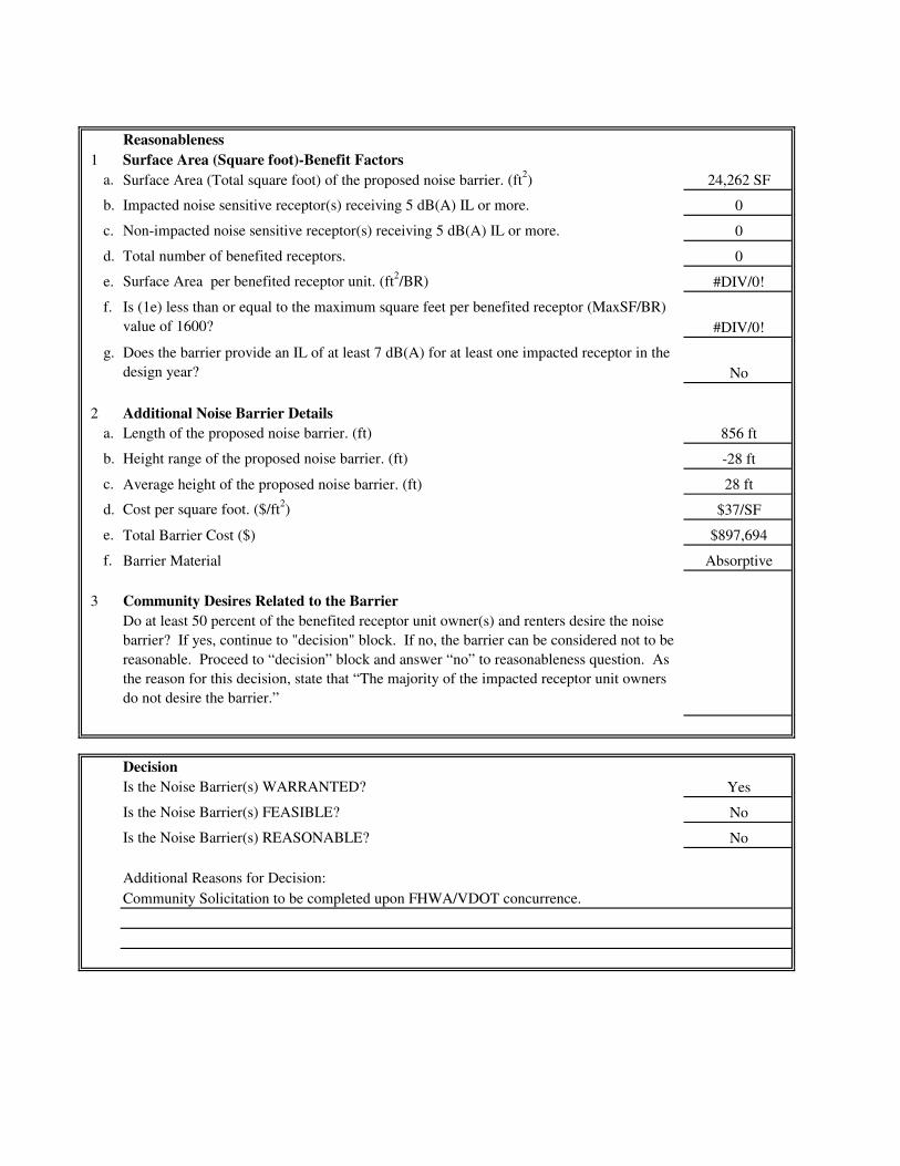
Reasonableness
1 Surface Area (Square foot)-Benefit Factors
a. 24,262 SF
b. 0
c. 0
d. 0
e. Surface Area per benefited receptor unit. (ft2/BR) #DIV/0!
f.
#DIV/0!
g.
No
2 Additional Noise Barrier Details
a. Length of the proposed noise barrier. (ft) 856 ft
b. Height range of the proposed noise barrier. (ft) -28 ft
c. Average height of the proposed noise barrier. (ft) 28 ft
d. Cost per square foot. ($/ft2) $37/SF
e. Total Barrier Cost ($) $897,694
f. Barrier Material Absorptive
3 Community Desires Related to the Barrier
Decision
Is the Noise Barrier(s) WARRANTED? Yes
Is the Noise Barrier(s) FEASIBLE? No
Is the Noise Barrier(s) REASONABLE? No
Additional Reasons for Decision:
Community Solicitation to be completed upon FHWA/VDOT concurrence.
Do at least 50 percent of the benefited receptor unit owner(s) and renters desire the noise
barrier? If yes, continue to "decision" block. If no, the barrier can be considered not to be
reasonable. Proceed to “decision” block and answer “no” to reasonableness question. As
the reason for this decision, state that “The majority of the impacted receptor unit owners
do not desire the barrier.”
Is (1e) less than or equal to the maximum square feet per benefited receptor (MaxSF/BR)
value of 1600?
Total number of benefited receptors.
Impacted noise sensitive receptor(s) receiving 5 dB(A) IL or more.
Does the barrier provide an IL of at least 7 dB(A) for at least one impacted receptor in the
design year?
Non-impacted noise sensitive receptor(s) receiving 5 dB(A) IL or more.
Surface Area (Total square foot) of the proposed noise barrier. (ft2)

Date:
Project No. and UPC:
County:
District:
Barrier System ID:
Community Name and/or CNE#
Noise Abatement Category(s)
Design phase:
Warranted
1 Community Documentation (if applicable)
a.
NA
b.
NA
2 Criteria requiring consideration of noise abatement
b. Project causes a substantial noise increase of 10 dB(A) or more? Yes
Feasibility
1 Impacted receptor units
a. Number of impacted receptor units: 3
b. Number of impacted receptor units receiving 5 dB(A) or more insertion loss (IL): 3
c. Percentage of impacted receptor units receiving 5 dB(A) or more IL 100%
d. Is the percentage 50 or greater? Yes
2No
3 Will placement of the noise barrier restrict access to vehicular or pedestrian travel? No
4 Will placement of the noise barrier conflict with existing utility locations? No
Preliminary design
Date community was permitted. (Per 23CFR 772 this is the date the building permit was
issued).
Date of approval for the Categorical Exclusion (CE), Record of Decision (ROD), or
Finding of No Significant Impact (FONSI):
Will placement of the noise barrier cause engineering or safety conflicts, e.g drainage
issues or site distance issues?
Does the date in 1.a precede the date in 1.b? If yes, proceed to Warranted Item 2. If no,
consideration of noise abatement is not warranted. Proceed to “Decision” block and
answer “no” to warranted question. As the reason for this decision, state that “Community
was permitted after the date of approval of CE, ROD, or FONSI, as appropriate.”
CNE P
CNE P
B
VDOT Highway Traffic Noise Abatement
Warranted, Feasible, and Reasonable Worksheet
6-Aug-12
0029-002-844, P101; UPC 102419
Albemarle
Note: Not all questions apply depending on the design phase which may cause differing answers between
preliminary and final design phase. Answers to the questions may change depending on the design phase of
the project.
Project causes design year noise levels to approach or exceed the Noise Abatement
Criteria? Yes
a.
c.
NA

Reasonableness
1 Surface Area (Square foot)-Benefit Factors
a. 21,000 SF
b. 3
c. 5
d. 8
e. Surface Area per benefited receptor unit. (ft2/BR) 2,625 SF/BR
f.
No
g.
Yes
2 Additional Noise Barrier Details
a. Length of the proposed noise barrier. (ft) 1,755 ft
b. Height range of the proposed noise barrier. (ft) -12 ft
c. Average height of the proposed noise barrier. (ft) 12 ft
d. Cost per square foot. ($/ft2) $37/SF
e. Total Barrier Cost ($) $777,000
f. Barrier Material Absorptive
3 Community Desires Related to the Barrier
Decision
Is the Noise Barrier(s) WARRANTED? Yes
Is the Noise Barrier(s) FEASIBLE? Yes
Is the Noise Barrier(s) REASONABLE? No
Additional Reasons for Decision:
Does the barrier provide an IL of at least 7 dB(A) for at least one impacted receptor in the
design year?
Non-impacted noise sensitive receptor(s) receiving 5 dB(A) IL or more.
Surface Area (Total square foot) of the proposed noise barrier. (ft2)
Do at least 50 percent of the benefited receptor unit owner(s) and renters desire the noise
barrier? If yes, continue to "decision" block. If no, the barrier can be considered not to be
reasonable. Proceed to “decision” block and answer “no” to reasonableness question. As
the reason for this decision, state that “The majority of the impacted receptor unit owners
do not desire the barrier.”
Is (1e) less than or equal to the maximum square feet per benefited receptor (MaxSF/BR)
value of 1600?
Total number of benefited receptors.
Impacted noise sensitive receptor(s) receiving 5 dB(A) IL or more.
Community Solicitation to be completed upon FHWA/VDOT concurrence.

Appendix G
REFERENCES

References
• Virginia Department of Transportation, Highway Traffic Noise Impact Analysis Guidance Manual, approved March 15, 2011, effective July 13, 2011, updated September 16, 2011.
• Virginia Department of Transportation, Section 107.14(b) 3 Noise (VDOT, 2002). • Virginia State Noise Abatement Policy. • Federal Highway Administration, Federal Aid Policy Guide 23 CFR 772, U.S.
Government Printing Office, updated December 9, 1991. • U.S. Department of Transportation, Federal Highway Administration, “FHWA
Traffic Noise Model User’s Guide,” FHWA Report No. FHWA-PD-96-009, January 1998.
• U.S. Department of Transportation, Federal Highway Administration, “Highway
Traffic Noise Analysis and Abatement Policy and Guidance,” June 1995.
• U.S. Department of Transportation, Federal Highway Administration, “Measurement of Highway-Related Noise,” FHWA Report No. FHWA-PD-96-046, May 1996.

Appendix H
LIST OF PREPARERS & REVIEWERS

List of Preparers / Reviewers McCormick Taylor, Inc. Josh J. Wilson Senior Acoustical Scientist Education: B.S., Geo-Environmental Studies M.S., Geo-Environmental Studies Professional Experience: 11.3 Years Role: Project Coordination, Noise Modeling, and Report Preparation Rich A. Butala Contract Manager Education: B.S., Environmental Resource Management Professional Experience: 24.5 Years Role: QA/QC Jack A. Cramer Air Quality and Acoustical Scientist Education: B.S., Geo-Environmental Studies Professional Experience: 12.2 Years Role: Report Preparation Brennan Snyder Collier Senior Environmental Planner, Associate. Education: B.A., Interdisciplinary Studies – Environmental Science B.A., Geology Professional Experience: 15.3 Years Role: QA/QC Virginia Department of Transportation Paul Kohler VDOT Noise Abatement Section Manager Education: B.S. Terrestrial Ecology Professional Experience: 19.5 Years Role: Technical Analysis Reviewer LJ Muchenje, P.E. VDOT Noise Abatement Engineer Education: B.S. Mechanical Engineering Professional Experience: 5 Years Role: Technical Analysis Reviewer