· web viewthe twister touched down near long lake, snapping or uprooting hundreds of trees as it...
TRANSCRIPT
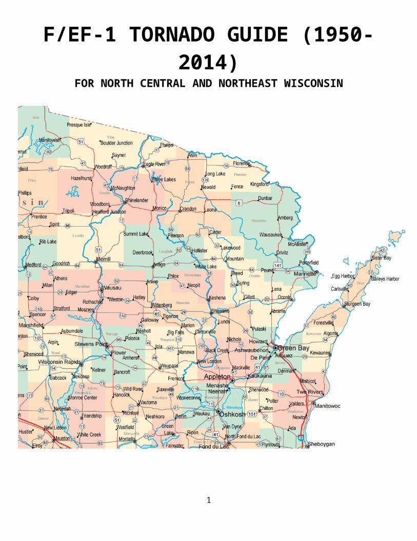
F/EF-1 TORNADO GUIDE (1950-2014)FOR NORTH CENTRAL AND NORTHEAST WISCONSIN
1
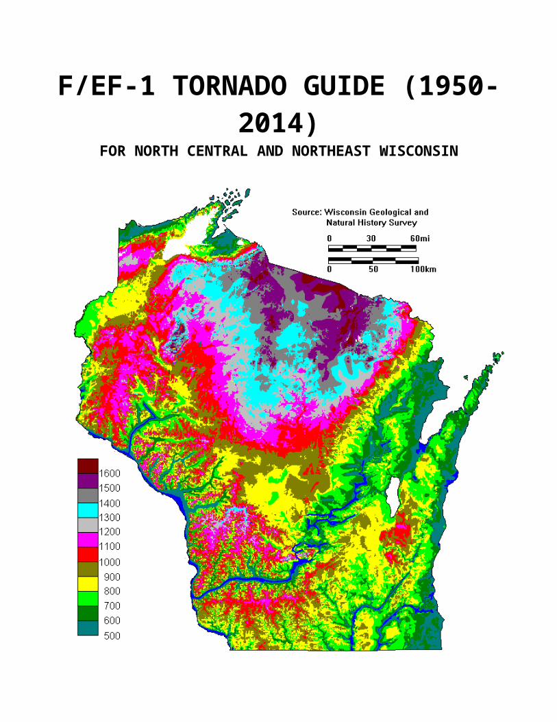
F/EF-1 TORNADO GUIDE (1950-2014)FOR NORTH CENTRAL AND NORTHEAST WISCONSIN
2
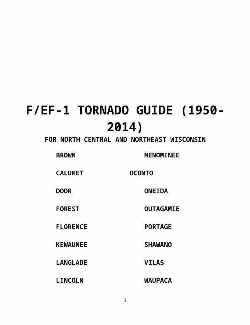
F/EF-1 TORNADO GUIDE (1950-2014)FOR NORTH CENTRAL AND NORTHEAST WISCONSIN
BROWN MENOMINEE
CALUMET OCONTO
DOOR ONEIDA
FOREST OUTAGAMIE
FLORENCE PORTAGE
KEWAUNEE SHAWANO
LANGLADE VILAS
LINCOLN WAUPACA
MANITOWOC WAUSHARA
MARATHON WINNEBAGO
MARINETTE WOOD
3
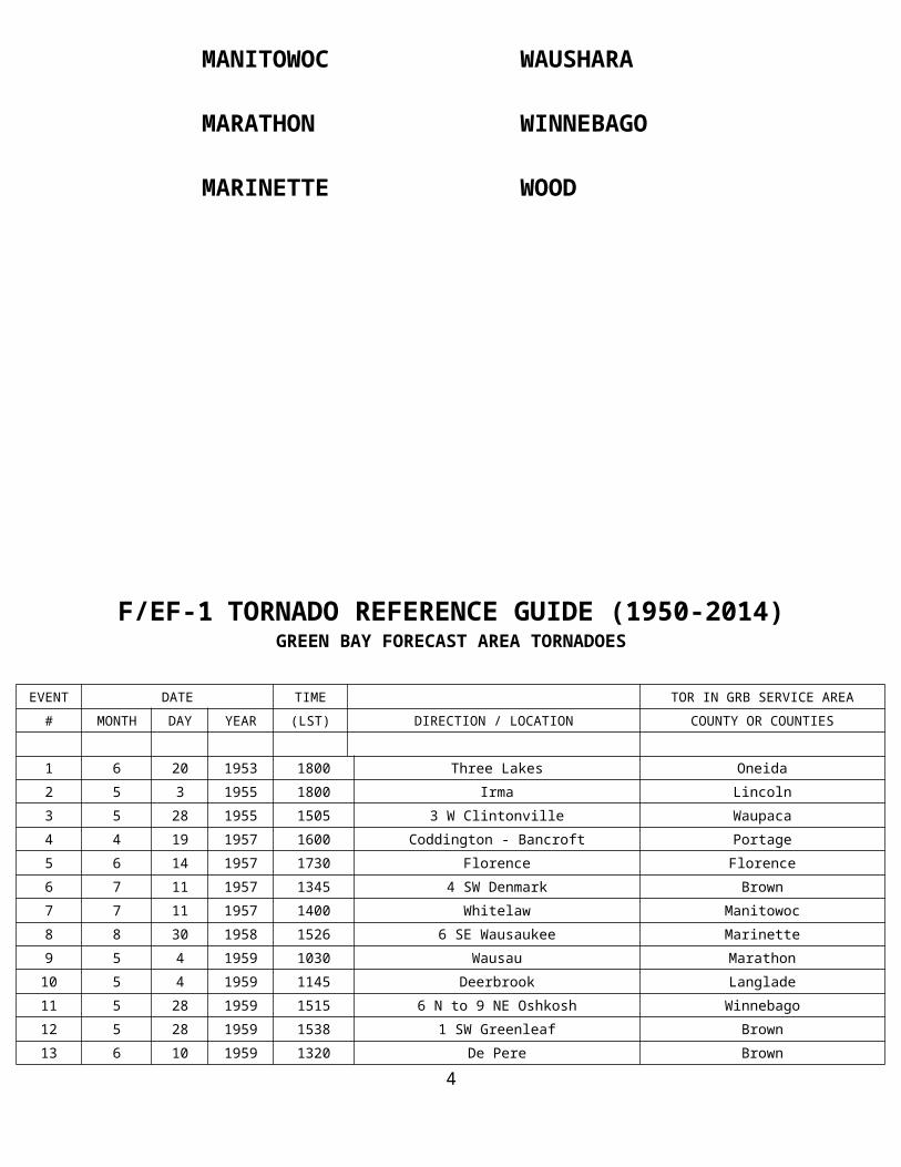
F/EF-1 TORNADO REFERENCE GUIDE (1950-2014)GREEN BAY FORECAST AREA TORNADOES
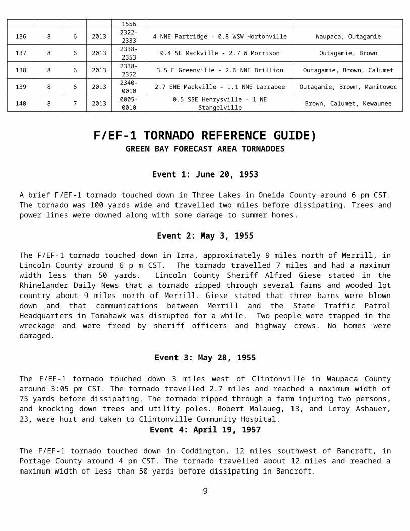
EVENT DATE TIME TOR IN GRB SERVICE AREA
# MONTH DAY YEAR (LST) DIRECTION / LOCATION COUNTY OR COUNTIES
1 6 20 1953 1800 Three Lakes Oneida
2 5 3 1955 1800 Irma Lincoln
3 5 28 1955 1505 3 W Clintonville Waupaca
4 4 19 1957 1600 Coddington - Bancroft Portage
5 6 14 1957 1730 Florence Florence
6 7 11 1957 1345 4 SW Denmark Brown
7 7 11 1957 1400 Whitelaw Manitowoc
8 8 30 1958 1526 6 SE Wausaukee Marinette
9 5 4 1959 1030 Wausau Marathon
10 5 4 1959 1145 Deerbrook Langlade
11 5 28 1959 1515 6 N to 9 NE Oshkosh Winnebago
12 5 28 1959 1538 1 SW Greenleaf Brown
13 6 10 1959 1320 De Pere Brown
14 4 24 1960 1600 7 SW Valders Manitowoc
15 5 21 1960 1730 15 W Oshkosh Winnebago
16 9 3 1961 0100 Athens Marathon
17 9 3 1961 1700 12 W Merrill Lincoln
18 6 23 1962 1630-1635 2 W Champion Brown
19 9 19 1963 1800 Laona Forest
20 5 4 1964 1800-1810 10 SW St. Germain to near St. Germain Oneida, Vilas
21 6 9 1964 1455 Belle Plaine Shawano
22 7 10 1966 2200 Plainfield - Wautoma Waushara
23 7 1 1967 0045 3 E Kiel Manitowoc
24 7 2 1967 1400 Brillion Calumet
25 6 30 1968 0445 3 S Pembine Marinette
26 8 5 1968 1400 3 NW Seymour Outagamie
27 6 26 1969 1630 2 W Manitowish Waters - 3 SW Presque Is. Vilas
28 6 26 1969 1700 Skanawank - Pelican Lake Lincoln
29 7 2 1969 1620 3 SW Luxemburg - Ellisville Kewaunee
30 4 22 1970 2110 2 NE Poland - 4 SE Luxemburg Brown, Kewaunee
31 7 7 1970 1900 Winchester - Boulder Junction - Conover Vilas
32 7 14 1970 1230 Marion Waupaca
33 7 14 1970 1400 McAllister Marinette
34 7 30 1970 1205 4 W Suamico Brown
35 12 1 1970 0700 Hull Portage
F/EF-1 TORNADO REFERENCE GUIDE (1950-2014)4
GREEN BAY FORECAST AREA TORNADOES
EVENT DATE TIME TOR IN GRB SERVICE AREA
# MONTH DAY YEAR (LST) DIRECTION / LOCATION COUNTY OR COUNTIES
36 5 18 1971 1640-1704 Adams-Friendship - Hancock Waushara
37 6 6 1971 2315 5 SW Oshkosh Winnebago
38 6 13 1971 1630 8 NW Oshkosh Winnebago
39 6 18 1971 1345 5 W Marinette Marinette
40 7 8 1971 0200 Wisconsin Rapids Wood
41 8 21 1972 1510 Goodwin - Two Rivers Manitowoc
42 3 11 1973 1030 2 E Calumetville Calumet
43 5 9 1973 1550 2 N Reedsville Manitowoc
44 6 3 1973 1815 2 NE Amberg Marinette
45 6 18 1973 1100 2 W Athens Marathon
46 7 12 1973 300 Boulder Junction - Sayner Vilas
47 7 12 1973 0730 Jacksonport Door
48 7 12 1973 0800 4 W Freedom Outagamie
49 6 9 1974 1445 Bancroft Portage
50 6 14 1974 1610 5 NW Gillett Oconto
51 6 12 1976 2100 Amherst Portage
52 6 13 1976 1840-1920 4 W Wisconsin Rapids - 3 NE Stevens Point Portage
53 6 13 1976 2000-2100 2 W Hogarty - Elton Langlade, Marathon
54 6 13 1976 2000 5 E Seymour Outagamie
55 6 13 1976 2015 Oconto Falls Oconto
56 6 13 1976 2045 9 E Merrill to 11 NW Antigo Langlade, Lincoln
57 7 30 1977 2245 0.5 N Forest Junction - 3 W Denmark Brown
58 5 8 1978 1650-1700 1.5 SW - 2.5 SE Luxemburg Kewaunee
59 6 16 1979 1530-1545 2 N - 2 NE Irma Lincoln
60 6 20 1979 1345 3 S Oshkosh Winnebago
61 6 20 1979 1430 Goodman Marinette
62 8 4 1979 1000 Manitowoc Manitowoc
63 8 9 1979 1856 Green Bay - northeast Brown
64 5 30 1980 1430 4 S Shawano Shawano
65 5 30 1980 1520 Oconto Oconto
66 5 30 1980 1605-1614 Black Creek Outagamie
67 6 14 1980 1230 5 NW Manawa - Manawa Waupaca
68 6 14 1980 1325 1 E Rhinelander - Lake Thompson Oneida
69 7 5 1980 0030 Valders Manitowoc
70 9 20 1980 2315 Mattoon Shawano
F/EF-1 TORNADO REFERENCE GUIDE (1950-2014)GREEN BAY FORECAST AREA TORNADOES
5
EVENT DATE TIME TOR IN GRB SERVICE AREA
6
# MONTH DAY YEAR (LST) DIRECTION / LOCATION COUNTY OR COUNTIES
71 6 13 1981 2040 1 N Hazelhurst Oneida
72 6 13 1981 2045 Sayner - 3 NE Sayner Vilas
73 3 30 1982 1405-1440 Armenia - 3 SW Stevens Point Portage, Wood
74 7 15 1982 1915 Mayflower Lake Marathon
75 7 3 1983 0439 Eagle River Vilas
76 7 3 1983 1900 Birnamwood Shawano
77 7 19 1983 1925 Stockbridge Harbor Calumet
78 6 26 1984 1655 13 N Wausau - Texas Marathon
79 6 26 1984 1900 Caroline Shawano
80 7 24 1986 1415 Saint Germain Vilas
81 7 2 1987 1710-1715 Pike Lake Marathon
82 7 12 1987 1127-1130 1 S Francis Creek Manitowoc
83 8 14 1987 1740-1743 1 W Menasha Winnebago
84 5 8 1988 1706-1712 2 SE Wautoma - 1 S Mount Morris Waushara
85 7 29 1988 2030 Eagle River Vilas
86 8 1 1988 1852 1 W Saint Germain Vilas
87 8 4 1988 1435-1445 1 E Reedsville - 2 N Cato Manitowoc
88 5 24 1989 2010-2015 3 S Oshkosh Winnebago
89 5 24 1989 2105 4 WNW Chilton Calumet
90 6 12 1990 1835 2 W Stratford Marathon
91 6 14 1991 1155 8 WNW Merrill Lincoln
92 4 20 1992 1600-1620 2 SW Arpin - Bakerville Wood
93 5 16 1992 1430 5 N Junction City Portage
94 5 16 1992 1830 2.5 NE Northland Waupaca
95 5 16 1992 1920-1930 Kaukauna - 2 SW Wrightstown Outagamie, Brown
96 7 19 1992 1554 2 WSW Stratford Marathon
97 10 8 1992 1648 5 NE Wild Rose Waushara
98 10 8 1992 1712 4 NE Blaine Portage
99 4 26 1994 1455-1505 1.5 N Conover - 3 SE Land O'Lakes Vilas
100 7 8 1994 1400 3 NW Elderon Marathon
101 7 8 1994 1416 3 SE Aniwa Shawano
102 8 27 1994 2107 Hancock Waushara
103 8 27 1994 2141-2150 1.5 S Wausaukee - 3 SE Wausaukee Marinette
104 7 14 1995 1640-1647 Phelps Vilas
105 7 18 1996 1620-1630 1.5 SW - 3 SSE Tomahawk Lincoln
F/EF-1 TORNADO REFERENCE GUIDE (1950-2014)GREEN BAY FORECAST AREA TORNADOES
EVENT DATE TIME TOR IN GRB SERVICE AREA# MONTH DAY YEAR (LST) DIRECTION / LOCATION COUNTY OR COUNTIES
7
106 7 18 1996 1805-1807 1.1 S - 1.6 SE Jericho Calumet
107 8 7 1996 0146-0147 1 N - 1.2 NE Stratford Marathon
108 8 7 1996 0219-0221 0.44 SW Shantytown - Shantytown Marathon
109 7 16 1997 1509-1511 2 NE - 1.8 NE Ringle Marathon
110 5 31 1998 0120-0124 0.5 N Stockbridge - 2 NE Stockbridge Calumet
111 5 1 2001 2055-2100 0.4 NNE - NE Minocqua Oneida
112 4 18 2002 1813-1827 3 SE Stratford - 6 NW Mosinee Marathon
113 9 2 2002 1735-1743 6 NW Wausau - 4 NE Wausau Marathon
114 9 30 2002 1810-1811 5.5 SSE - 5.5 SE Spread Eagle Florence
115 8 3 2003 1359-1403 0.3 W - 0.2 ENE Potter Calumet
116 6 23 2004 1846-1848 3 NNW Almond - 3 NNE Almond Portage
117 6 23 2004 1853-1856 3 SE Blaine - 5 ESE Blaine Portage
118 6 23 2004 2000-2008 Little Chute - Kaukauna Outagamie
119 7 13 2004 1440-1452 1.4 NW Clark Mills to 2.8 SE Clark Mills Manitowoc
120 8 18 2005 1945 6 ENE - 6.8 ENE Wrightstown Brown
121 8 18 2005 2035 6.5 SSW - 5.7 S Manitowoc Manitowoc
122 6 7 2007 1637-1640 0.5 W -2.5 ENE Cedarville Marinette
123 6 7 2007 1716-1720 3.5 W Harmony to 1.2 N Harmony Marinette
124 7 19 2008 2144-2145 3.8 WNW to 3.4 WNW Menasha Winnebago
125 5 4 2010 1810-1812 2.7 SE Zittau to 2.7 W Winchester Winnebago
126 8 20 2010 1520-1522 2 SE- 2.7 ESE Greenleaf Brown
127 4 10 2010 1735-1742 2 NW Coloma – 4 ESE Hancock Adams, Waushara
128 4 10 2011 1750-1758 5 S Parish Langlade
129 4 10 2011 1806-1843 1 SW Saxeville – 1 SE Hortonville Waushara, Waupaca, Outagamie
130 4 10 2011 1853-1904 0.3 NW Poy Sippi – 2.3 WSW Winchester Waushara, Winnebago
131 4 10 2011 1903-1908 4.2 WNW – 3.2 N Armstrong Creek Forest
132 4 10 2011 1953-1955 1.2 NNE Askeaton – 1.4 S Greenleaf Brown
133 4 10 2011 1959-2001 1.6 NW Quinney – 1.5 SSE Stockbridge Calumet
134 5 22 2011 1703-1720 5.5 SSE Cranmoor – 4.8 SE Arnott Wood, Portage
135 8 19 2011 1545-1556 2.9 NW – 5.2 ESE Wausaukee Marinette
136 8 6 2013 2322-2333 4 NNE Partridge - 0.8 WSW Hortonville Waupaca, Outagamie
137 8 6 2013 2338-2353 0.4 SE Mackville - 2.7 W Morrison Outagamie, Brown
138 8 6 2013 2338-2352 3.5 E Greenville - 2.6 NNE Brillion Outagamie, Brown, Calumet
139 8 6 2013 2340-0010 2.7 ENE Mackville – 1.1 NNE Larrabee Outagamie, Brown, Manitowoc
140 8 7 2013 0005-0010 0.5 SSE Henrysville – 1 NE Stangelville Brown, Calumet, Kewaunee
F/EF-1 TORNADO REFERENCE GUIDE)GREEN BAY FORECAST AREA TORNADOES
Event 1: June 20, 1953
A brief F/EF-1 tornado touched down in Three Lakes in Oneida County around 6 pm CST. The tornado was 100 yards wide and travelled two miles before dissipating. Trees and power lines were downed along with some damage to summer homes.
8
Event 2: May 3, 1955
The F/EF-1 tornado touched down in Irma, approximately 9 miles north of Merrill, in Lincoln County around 6 p m CST. The tornado travelled 7 miles and had a maximum width less than 50 yards. Lincoln County Sheriff Alfred Giese stated in the Rhinelander Daily News that a tornado ripped through several farms and wooded lot country about 9 miles north of Merrill. Giese stated that three barns were blown down and that communications between Merrill and the State Traffic Patrol Headquarters in Tomahawk was disrupted for a while. Two people were trapped in the wreckage and were freed by sheriff officers and highway crews. No homes were damaged.
Event 3: May 28, 1955
The F/EF-1 tornado touched down 3 miles west of Clintonville in Waupaca County around 3:05 pm CST. The tornado travelled 2.7 miles and reached a maximum width of 75 yards before dissipating. The tornado ripped through a farm injuring two persons, and knocking down trees and utility poles. Robert Malaueg, 13, and Leroy Ashauer, 23, were hurt and taken to Clintonville Community Hospital.
Event 4: April 19, 1957
The F/EF-1 tornado touched down in Coddington, 12 miles southwest of Bancroft, in Portage County around 4 pm CST. The tornado travelled about 12 miles and reached a maximum width of less than 50 yards before dissipating in Bancroft.
Event 5: June 14, 1957
The F/EF-1 tornado touched down at Florence in Florence County around 5:30 pm CST. The tornado travelled approximately 8 miles and reached a maximum width of 100 yards before dissipating.
Event 6: July 11, 1957
The F/EF-1 tornado touched down 4 miles southwest of Denmark in Brown County around 1:45 pm CST. There was no documentation on the path width or distance travelled. A tornado also touched down in Manitowoc County fifteen minutes later.
Event 7: July 11, 1957
The F/EF-1 tornado was first reported to touch down two and a half miles southeast of White Law in Manitowoc County around 2 pm CST. The tornado struck the Bernard Vogel farm, picking up 9 trees thirty feet high and pounded them into the ground. The tornado also broke windows and gouged the side of the house. A female neighbor of Bernard Vogel, who was seeking shelter, was pinned up to the wall of a silo as she was running towards the house.
Event 8: August 30, 1958
The F/EF-1 tornado was reported 6 miles southeast of Wausaukee in Marinette County around 3:26 pm CST. The tornado was 100 yards wide and travelled a mile before dissipating.
F/EF-1 TORNADO REFERENCE GUIDE)GREEN BAY FORECAST AREA TORNADOES
Event 9: May 4, 1959
The F/EF-1 tornado was reported to touch down near Wausau in Marathon County around 10:30 am CST. The tornado was 200 yards wide and travelled a mile before dissipating near Wausau.
Event 10: May 4, 19599
The F/EF-1 tornado struck Deerbrook in Langlade County around 11:45 am CST. The tornado was 100 yards wide and was on the ground for a mile.
Event 11: May 28, 1959
The F/EF-1 tornado struck 6 miles north of Oshkosh in Winnebago County around 3:15 pm CST. The tornado travelled nine miles before dissipating 9 miles northeast of Oshkosh.
Event 12: May 28, 1959
The F/EF-1 tornado was spotted one mile southwest of Greenleaf in Brown County around 3:38 pm CST.
Event 13: June 10, 1959
The F/EF-1 tornado touched down near De Pere in Brown County around 1:20 pm CST. The tornado travelled about a mile and was less than twenty yards wide.
Event 14: April 24, 1960
The F/EF-1 tornado touched down 7 miles southwest of Valders in Manitowoc County around 4 pm CST. The tornado was less than 50 yards wide and travelled about a mile before dissipating.
Event 15: May 21, 1960
The F/EF-1 tornado touched down fifteen miles west of Oshkosh in Winnebago County around 5:30 pm CST.
Event 16: September 3, 1961
The F/EF-1 tornado touched down near Athens in Marathon County around 1 am CST. The tornado was 35 yards wide and was on the ground for 2 miles.
Event 17: September 3, 1961
The F/EF-1 tornado touched down 12 miles west of Merrill in Lincoln County around 5 pm CST. The tornado was 50 yards wide and was on the ground for a mile.
Event 18: June 23, 1962
The F/EF-1 tornado touched down 2 miles west of Champion in eastern Brown County around 4:30 pm CST. According to the local storm report for June of 1962, the tornado became or originated as a waterspout near Point Sauble as the storm was picking up water at times. The tornado/waterspout had a maximum width of less than 50 yards and travelled 3 miles before dissipating at 4:35 pm CST.
Event 19: September 19, 1963
The F/EF-1 tornado tore through the village of Laona in Forest County around 6 pm CST. The tornado was less than 50 yards wide and travelled one mile before dissipating.
F/EF-1 TORNADO REFERENCE GUIDE)GREEN BAY FORECAST AREA TORNADOES
Event 20: May 4, 1964
The F/EF-1 tornado was first reported 10 miles southwest of St. Germain in Oneida County around 6 pm CST. The tornado travelled just over 7 miles before dissipating near St. Germain at 6:10 pm CST in Vilas County. The tornado had a maximum width of 125 yards. The local storm report indicated the tornado touched down twice and crossed over the Big St. Germain drawing water to a height of 200 feet. There was considerable damage to resorts and woods in the path of the tornado.
10
Event 21: June 9, 1964
The F/EF-1 tornado was sighted in Belle Plaine in Shawano County around 2:55 pm CST. The Adams Beach area was hit the hardest according to newspaper reports.
Event 22: July 10, 1966
The F/EF-1 tornado was first reported to touch down in Plainfield in Waushara County around 10 pm CST. The tornado was 100 yards wide and travelled approximately fifteen and a half miles before dissipating at Wautoma.
Event 23: July 1, 1967
The F/EF-1 tornado struck 3 miles east of Kiel in Manitowoc County around 12:45 am CST. The tornado was 50 yards wide and travelled a half mile before dissipating.
Event 24: July 2, 1967
The city of Brillion in Calumet County was struck by an F/EF-1 tornado around 2 pm CST. The local storm report indicated a touchdown in the city of Brillion. The tornado was 35 yards wide and travelled a mile before dissipating.
Event 25: June 30, 1968
The F/EF-1 tornado touched down on the Zern property 3 miles south of Pembine in Marinette County around 4:45 am CST. The tornado was 100 yards wide and travelled on the ground for a half mile. Trees and a garage were destroyed by the tornado.
Event 26: August 5, 1968
The F/EF-1 tornado touched down 3 miles northwest of Seymour in Outagamie County around 2 pm CST. The tornado was 150 yards wide and was on the ground for two miles before dissipating. Nine barns and farm buildings were destroyed.
Event 27: June 26, 1969
According to the local storm report, the F/EF-1 tornado skipped northeast through the forests of Price, southeast Iron and western Vilas Counties. The tornado struck Vilas County from 2 miles west of Manitowish Waters around 4:30 pm CST and moved to three miles southwest of Presque Isle. Most of the damage occurred around Manitowish Waters.
Event 28: June 26, 1969
The F/EF-1 tornado travelled 22 miles across Clark, Taylor and Lincoln Counties. The tornado did major damage from the Withee area in northern Clark County around 4:10 pm CST. Two persons were injured and about ten farms sustained damage. Major damage from the tornado was reported at the Taylor County Airport near Medford around 4:30 pm CST. Seven planes and one hangar suffered severe damage. The tornado entered western Lincoln County and travelled to near Pelican Lake around 5 pm CST before dissipating. Five more farms suffered serious damage in northeast Lincoln County. Tree and wire damage termed “worst ever” by utilities in the northern resort areas.
F/EF-1 TORNADO REFERENCE GUIDE)GREEN BAY FORECAST AREA TORNADOES
Event 29: July 2, 1969
The F/EF-1 tornado traveled just over 7 miles across Kewaunee County, from 3 miles southwest of Luxemburg through the Ellisville area around 4:20 pm CST. The tornado had a maximum width of 100 yards. Several farms were damaged by the tornado.
Event 30: April 22, 1970
11
The F/EF-1 tornado developed 2 miles northeast of Poland in extreme eastern Brown County around 9:10 pm CST. The tornado was 500 yards wide and travelled just over 7 miles to near Luxemburg before dissipating. Several farms were damaged and leveled the Kewaunee County Fair Grandstand at Luxemburg.
Event 31: July 7, 1970
The F/EF-1 tornado developed across Iron County in northwest Wisconsin. The tornado traveled east southeastward for nearly 38 miles across Vilas County around 7 pm CST. The tornado travelled from Winchester to Boulder Junction to Conover. Extensive damage to woods and lake property were noted in the path of the tornado.
Event 32: July 14, 1970
The F/EF-1 tornado briefly touched down in Marion in Waupaca County around 12:30 pm CST. The tornado was less than 50 yards wide and travelled approximately a half mile. The tornado ripped a door off a factory, flipping over a car and damaging trucks and signs in Marion.
Event 33: July 14, 1970
The F/EF-1 tornado was reported in Mc Allister in Marinette County around 2 pm CST. The tornado was less than 50 yards wide and travelled a mile. The tornado damaged a home and uprooted several trees.
Event 34: July 30, 1970
A brief tornado touchdown (F/EF-1) occurred 4 miles west of Suamico in Brown County. The tornado was 33 yards wide and travelled a mile before dissipating. According to the local storm report, the tornado struck in open country.
Event 35: December 1, 1970
A rare tornado event occurred across north central and northeast Wisconsin on this date. In all, there were four tornadoes on this date, including an F/EF-3. What made this event even more unusual was the time of day with all four tornadoes reported between 7 am and 10:45 am in the morning. The F/EF-1 tornado touched down on the Richard Rutta farm in the town of Hall north of Stevens Point in Portage County. The tornado was 200 yards wide and travelled nearly 3 miles before dissipating.
Event 36: May 18, 1971
The F/EF-1 tornado was first sighted northeast of Adams and Friendship in Adams County around 4:40 pm CST. The tornado travelled 15 miles as it moved across Highway 21 and then to Hancock in western Waushara County before dissipating around 5:04 pm CST. The tornado reached a maximum width of 100 yards. After crossing Highway 21, the tornado destroyed two house trailers injuring five people and smashed a barn. In Hancock, a large metal warehouse was severely damaged with sheet metal scattered a half mile downwind.
F/EF-1 TORNADO REFERENCE GUIDE)GREEN BAY FORECAST AREA TORNADOES
Event 37: June 6, 1971
The F/EF-1 tornado was reported 5 miles southwest of Oshkosh in Winnebago County around 11:15 pm CST. The tornado was 50 yards wide and travelled nearly 4 miles before it dissipated. The tornado demolished one barn and damaged several others on highway 26 about five miles southwest of Oshkosh.
12
Event 38: June 13, 1971
The public reported the tornado 8 miles northwest of Oshkosh in Winnebago County around 4:30 pm CST. The F/EF-1 tornado was 50 yards wide and only travelled a quarter of a mile. Many trees were down in small grove eight miles northwest of Oshkosh.
Event 39: June 18, 1971
The F/EF-1 tornado struck about 5 miles west of Marinette in Marinette County, near Highway 64 and Right O Way Road around 1:45 pm CST. The tornado was 100 yards wide and travelled just over four miles before it dissipated. Many trees were uprooted and several resort and farm buildings were damaged.
Event 40: July 8, 1971
The F/EF-1 tornado moved through open country just north of Wisconsin Rapids in Wood County around 2 am CST. The tornado was 75 yards wide and travelled about two miles before it dissipated. One house trailer moved off its foundation while there was damage to trees in the area.
Event 41: August 21, 1972
The F/EF-1 tornado touched down near Goodwin in Manitowoc County around 3:10 pm CST. The tornado was 50 yards wide and travelled approximately 12 miles to Two Rivers. The tornado struck the Van Koevering residence, uprooting five large trees in the yard. Tree and wire damage occurred along Highway 147 one mile south of Mishicot and near Highway 42 and near Shambeau Road near Two Rivers. The tornado moved eastward out over Lake Michigan.
Event 42: March 11, 1973
An early season F/EF-1 struck Calumet County, 2 miles east of Calumetville around 10:30 am CST. The tornado was 50 yards wide and travelled two miles before dissipating.
Event 43: May 9, 1973
The F/EF-1 was reported 2 miles north of Reedsville in Manitowoc County around 3:50 pm CST. The tornado was 50 yards wide and travelled about two miles before dissipating. Several outbuildings were destroyed on the John Zimmerman farm on Highway 32. Damage was also reported on the Sullivan and Fenlon farms.
Event 44: June 3, 1973
The F/EF-1 tornado first touched down just north of Amberg in Marinette County around 6:15 pm CST. The tornado was 100 yards wide and moved four and a half miles across Marinette County before dissipating. The tornado upended several house trailers and destroyed several wooden structures at the Sparkling Springs Campground just north of Amberg. Several acres of trees were leveled at the campsite and northeastward to Assembly of God Church in Beecher Township.
F/EF-1 TORNADO REFERENCE GUIDE)GREEN BAY FORECAST AREA TORNADOES
Event 45: June 18, 1973
The F/EF-1 tornado touched down on the Brunke Farm 2 miles west of Athens in Marathon County around 11 am CST. The tornado was 200 yards wide and travelled east for two miles before dissipating.
Event 46: July 12, 197313
The F/EF-1 tornado was struck touchdown just south of Boulder Junction in Vilas County around 3 am CST. The tornado was 100 yards wide and travelled 19.5 miles before dissipating near Sayner in Vilas County. Scattered damage to the woods was reported along the path of the tornado
Event 47: July 12, 1973
The F/EF-1 tornado touched down in Jacksonport in Door County around 7:30 am CST. The tornado was 100 yards wide and travelled 3 miles. Scattered damage was reported west and south of Jacksonport. As many as six waterspouts were reported by one observer off Jacksonport. A seiche caused a drop of two feet in water level locally about fifteen minutes after passage of the storms.
Event 48: July 12, 1973
The F/EF-1 tornado developed 4 miles west of Freedom in Outagamie County around 8 am CST. The tornado was 100 yards wide and travelled one mile. Farm buildings were destroyed on the Ken Geiger farm 4 miles west of Freedom.
Event 49: June 9, 1974
The tornado formed in Adams County and then the F/EF-1 tornado moved into southwest Portage County where it touched down briefly on the Sawyer Farm Route 1, Bancroft around 2:45 pm CST. The tornado was 30 yards wide and travelled two and a half miles. The tornado damaged a barn, a chicken coop and a porch on house. Only minor tree damage was noted.
Event 50: June 14, 1974
On the afternoon of June 14th, the F/EF-1 tornado touched down 5 miles northwest of Gillett in Oconto County around 4:10 pm CST. The tornado was 30 yards wide and travelled only a quarter of a mile. The tornado downed trees and power lines and threw a chopper wagon thirty yards.
Event 51: June 12, 1976
The F/EF-1 tornado touched down near Amherst in Portage County around 9 pm CST. The tornado was 50 yards wide and travelled around a quarter of a mile. The Amherst High School roof was ripped off.
Event 52: June 13, 1976
The F/EF-1 tornado formed 4 miles west of Wisconsin Rapids in Wood County around 6:40 pm CST. The tornado continued to move east northeast to three miles northeast of Stevens Point near the intersection of Highway 51 and Business 51 before dissipating around 7:20 pm CST three miles northeast of Stevens Point. The tornado traveled nineteen miles and reached a maximum width of 100 yards. Many trees were flattened. In Stevens Point, scattered damage was reported just north of the city and a roof was blown off an apartment complex. Several other buildings also suffered damage. Two people in the apartment complex were injured from fallen debris.
F/EF-1 TORNADO REFERENCE GUIDE)GREEN BAY FORECAST AREA TORNADOES
Event 53: June 13, 1976
The F/EF-1 tornado hit first about two miles west of Hogarty in Marathon County around 8 pm CST. The tornado skipped along and moved east northeast into extreme southwest Langlade County near Elmhurst and then continued to near Elton before dissipating at 8:10 pm. The tornado was 50 yards wide and travelled 21.3 miles. Some sheds were destroyed while windows of some buildings were damaged. Tree limbs and power lines were downed by the tornado.
14
Event 54: June 13, 1976
The tornado (F/EF-1) developed near county highway H and Highway 54 about five miles east of Seymour in Outagamie County around 8 pm CST. The tornado was 50 yards wide and travelled a half mile. Three barns were destroyed.
Event 55: June 13, 1976
The F/EF-1 tornado developed just west of Oconto Falls in Oconto County around 8:15 pm CST. The tornado was 50 yards wide and travelled less than a quarter of a mile. The damage from the tornado included: a barn was destroyed, a farm house was damaged, trees and power lines were down and a good portion of an orchard was destroyed.
Event 56: June 13, 1976
The F/EF-1 tornado first reached the ground near Highway 64 in extreme southeast Lincoln County around 8:45 pm CST. The tornado then moved into western Langlade County about 3 miles north of Highway 64. The tornado skipped along to near county Highway I about 11 miles northwest of Antigo where it was last reported. The tornado was 50 yards wide and travelled nearly eleven miles. The only report of damage was some downed trees.
Event 57: July 30, 1977
The F/EF-1 tornado initially developed a half mile west of Forest Junction in Brown County around 10:45 pm CST, destroying a rural farm including a large barn, milk house and several small sheds. The tornado was 100 yards and travelled twelve miles before dissipating in Denmark. In Denmark, a roof of an apartment building was blown off, a couple of garages were destroyed and some farm machinery was toppled.
Event 58: May 8, 1978
The F/EF-1 tornado developed a mile and a half southwest of Luxemburg in Kewaunee County around 4:50 pm CST, and then moved to two and a half miles southeast of Luxemburg before dissipating around 5 pm CST. Two buildings were destroyed a mile and a half west of Luxemburg on Highway 54. A large pole building was destroyed two and a half miles southeast of Luxemburg.
Event 59: June 16, 1979
The F/EF-1 tornado developed 2 miles north of Irma in Lincoln County around 3:30 pm CST. The tornado moved to 2 miles northeast of Irma before dissipating at 3:45 pm CST.
Event 60: June 20, 1979
The F/EF-1 tornado touched down 3 miles south of Oshkosh in Winnebago County around 1:45 pm CST. The tornado on this date followed almost the same path as another more destructive twister that hit the city in April 1974. The tornado destroyed two mobile homes and severely damaged five others. Four people were hospitalized due to the injuries they suffered from the tornado.
F/EF-1 TORNADO REFERENCE GUIDE)GREEN BAY FORECAST AREA TORNADOES
Event 61: June 20, 1979
Goodman in Marinette County was hit by the F/EF-1 tornado around 2:30 pm CST. The tornado tore the roof off Louisiana Pacific Corps Seaway Division. Clarence Richards, personnel manager said 100 to 125 people were working inside the building when the tornado struck. Company officials said some of the workers were trapped when the roof collapsed. Only one injury was reported. There was no documentation on path length or width of the tornado.
15
Event 62: August 4, 1979
The tornado (F/EF-1) struck near Manitowoc in Manitowoc County around 10 am CST. Several buildings on a farm were destroyed. There was no documentation on path length or width of the tornado.
Event 63: August 9, 1979
The northeast side of Green Bay in Brown County was struck by the F/EF-1 tornado around 6:56 pm CST. There was no documentation on path length or width of the tornado.
Event 64: May 30, 1980
The F/EF-1 tornado touched down at Highway187 four miles south of Shawano in Shawano County around 2:30 pm CST. The tornado was 50 yards wide and travelled 2 miles before dissipating. A house trailer was destroyed and scattered debris two miles to the northeast.
Event 65: May 30, 1980
The F/EF-1 tornado touched down at Highway 22 and Highway J near Oconto in Oconto County around 3:20 pm CST. The tornado was 50 yards wide and travelled one mile. Several buildings and cars were damaged as well as twisting off several trees.
Event 66: May 30, 1980
The F/EF-1 tornado touched down about 2 miles outside of Black Creek in Outagamie County around 4:05 pm CST. The tornado travelled east around 4 miles before dissipating around 4:14 pm CST two miles east of Black Creek. An intermittent four mile path 50 yards wide resulted in damage to several garages in Black Creek.
Event 67: June 14, 1980
The tornado (F/EF-1) developed about 5 miles northwest of Manawa at Highway 161 near County Highway E in Waupaca County around 12:30 pm CST. The tornado crossed Highway 161 and then turned eastward and dissipated near Manawa. The tornado was 50 yards wide and travelled five miles before dissipating. Several residents in the area took several spectacular photographs of the twister.
Event 68: June 14, 1980
A small tornado (F/EF-1) formed at Highway C one mile east of Rhinelander in Oneida County at 1:25 pm CST. The tornado was 50 yards wide and travelled eastward for a mile and a half before the tornado dissipated over Lake Thompson. A falling tree injured one person seriously and two other injuries were noted in a trailer court. One house and three trailers and several rural buildings suffered damage.
Event 69: July 5, 1980
The F/EF-1 tornado struck the farm of Warren Otto just south of Valders in Manitowoc County around 12:30 am CST. There was no documentation on path length or width of the tornado. The tornado destroyed a barn and machine shed, and farm machinery on the Warren Otto farm. Other farm buildings in the area also sustained minor damage.
F/EF-1 TORNADO REFERENCE GUIDE)GREEN BAY FORECAST AREA TORNADOES
Event 70: September 20, 1980
The Mattoon area of Shawano County was struck by the F/EF-1 tornado around 11:15 pm CST. The tornado was 35 yards wide and travelled a half mile before dissipating. Several buildings were damaged by the tornado.
Event 71: June 13, 1981
16
The F/EF-1 tornado touched down at the Timber Ridge Country Club on Route 51 one mile north of Hazelhurst in Oneida County around 8:40 pm. There was no documentation on path length or width of the tornado. The tornado destroyed about one thousand trees.
Event 72: June 13, 1981
The F/EF-1 tornado touched down at County Highway N about a half mile north Sayner. The tornado moved east for three miles through the dense forest and cross the intersection of Highway N and Highway G then dissipated. The tornado damaged electric lines, telephone poles and trees. The tornado was fifty yards wide.
Event 73: March 30, 1982
The tornado initially touched down in the township of Armenia in Juneau County where it destroyed a house and 3 nearby mobile homes. Two occupants of the house were injured. The F/EF-1 tornado then moved northeast to just southeast of Nekoosa in Wood County around 2:05 pm CST. The tornado traveled intermittently on a 28 mile path before dissipating 3 miles southwest of Stevens Point in Portage County around 2:40 pm CST.
Event 74: July 15, 1982
The F/EF-1 tornado swept southeast from May Flower Lake into rural areas at the south end of the lake in Marathon County around 7:15 pm CST. The tornado was 50 yards wide and travelled three quarters of a mile. Several trees were downed and one residence was damaged.
Event 75: July 3, 1983
The Eagle River Municipal Airport in Vilas County was hit by the F/EF-1 tornado at 4:39 am CST. The tornado was 20 yards wide and travelled a half mile before dissipating. Two single engine planes were destroyed and thirteen others were damaged. Five eighths inch ropes holding the planes down were shredded. One plane cart wheeled four hundred feet.
Event 76: July 3, 1983
The F/EF-1 tornado touched down in Birnamwood in Shawano County around 7 pm CST. The tornado was 50 yards wide and travelled a half mile.
Event 77: July 19, 1983
The tornado (F/EF-1) touched down at Stockbridge Harbor in Calumet County around 7:25 pm CST. The tornado smashed a shed roof and damaged two homes near Lake Shore Drive. The tornado turned east southeast damaging two garages and a barn on Military Road and then Hickory Hill Road where the roof of a mobile home was destroyed. The tornado was 100 yards wide and travelled 2 miles before dissipating.
Event 78: June 26, 1984
The F/EF-1 tornado touched 13 miles north of Wausau in Marathon County around 4:55 pm CST. The tornado was 100 yards wide and skipped eastward for 8 miles before dissipating in the town of Texas. The tornado damaged four homes and three farm buildings. It also destroyed a few sheds and uprooted trees.
F/EF-1 TORNADO REFERENCE GUIDE)GREEN BAY FORECAST AREA TORNADOES
Event 79: June 26, 1984
The F/EF-1 tornado touched down on the west side of Caroline in Shawano County around 7 pm CST. The tornado was 50 yards wide and travelled 4 miles before dissipating east of Caroline. On the west side of Caroline, the tornado flattened sheds and knocking over several large trees and gravestones in a cemetery. A church roof was ripped off on the east side of Caroline. The entire town was without power for three hours.
17
Event 80: July 24, 1986
The F/EF-1 tornado briefly touched down around 2:15 pm CST on South Shore Drive near Little St. Germain Lake near St. Germain in Vilas County. The tornado was 50 yards wide and travelled a quarter of a mile. Five buildings, some garages, some boats and docks were damaged. A dozen trees were snapped off at the base.
Event 81: July 2, 1987
A brief tornado touched down just east of Pike Lake in Marathon County around 5:10 pm CST. The F/EF-1 tornado was 75 yards wide and travelled two tenths of a mile before dissipating around 5:15 pm CST. Numerous trees were twisted and knocked down causing damage to seven homes, a boat trailer and one boat foundation.
Event 82: July 12, 1987
The F/EF-1 tornado touched down one mile south of Francis Creek in Manitowoc County around 11:27 am CST. The tornado was 75 yards wide and travelled two tenths of a mile before dissipating around 11:30 am CST. One house and a garage were destroyed. A barn, shed and several trees were also damaged. Debris from the house was found as far as several miles away.
Event 83: August 14, 1987
Considerable damage from the F/EF-1 tornado occurred one mile west of Menasha in Winnebago County between 5:40 and 5:43 pm CST. The tornado was 100 yards wide and travelled a quarter of a mile. Most of the damage occurred at a warehouse where siding and a roof were twisted and ripped away. Two 100 square foot cement slabs were also torn from the building. Trees and power lines were downed as well.
Event 84: May 8, 1988
In Waushara County, the F/EF-1 tornado travelled 5 miles from one mile south of Mount Morris to 3 miles northeast of Wild Rose between 5:06 and 5:12 pm CST. The tornado was 100 yards wide. Damage to structures and trees were reported along Silver Lake.
Event 85: July 29, 1988
The brief tornado touched down in the Eagle River in Vilas County around 8:30 pm CST. The tornado was 50 yards wide and only travelled a tenth of a mile. The F/EF-1 tornado damaged the Northland Pines High School in Eagle River. Winds accompanying the storm downed signs and trees in the Eagle River area.
Event 86: August 1, 1988
The F/EF-1 tornado touched one mile west of St. Germain in Vilas County around 6:52 pm CST. The tornado was 50 yards wide and travelled one mile. The tornado caused falling trees to damage cars and buildings one mile west of St. Germain. Another tornado (F/EF-0) was reported at 7:22 pm CST two miles southeast of Eagle River.
F/EF-1 TORNADO REFERENCE GUIDE)GREEN BAY FORECAST AREA TORNADOES
Event 87: August 4, 1988
The F/EF-1 tornado developed one mile east of Reedsville in Manitowoc County around 2:35 pm CST. The tornado was 25 yards wide and travelled 4 miles before dissipating two miles north of Cato around 2:45 pm CST. Two barns, one shed and several trees were damaged by the tornado.
Event 88: May 24, 1989
18
The F/EF-1 tornado touched down 3 miles south of Oshkosh in Winnebago County between 8:10 and 8:15 pm CST. The tornado was 50 yards wide and travelled 1.2 miles before dissipating.
Event 89: May 24, 1989
The F/EF-1 tornado touched down 4 miles west northwest of Chilton in Calumet County around 9:05 pm CST. The tornado was 50 yards wide and was on the ground for a quarter of a mile.
Event 90: June 12, 1990
The F/EF-1 tornado hit a farm 2 miles west of Stratford in Marathon County around 6:35 pm CST. The tornado was 25 yards wide and was only on the ground for a tenth of a mile. According to newspaper reports, there was damage to some farm structures.
Event 91: June 14, 1991
The tornado touched down 8 miles west northwest of Merrill in Lincoln County around 11:55 am CST. The F/EF-1 tornado was 50 yards wide and was on the ground for a mile. The tornado destroyed several trees, a barn and damaged a roof and porch of a house.
Event 92: April 20, 1992:
The F/EF-1 tornado formed 2 miles southwest of Arpin in Wood County around 4 pm CST. The tornado was 25 yards wide and travelled 9.5 miles before dissipating a half mile south of Bethel or near Bakerville around 4:20 pm CST. Damage included: a shed was knocked down near Arpin, a mobile home was picked up and twisted around near Bethel and some roof damage was reported at Bakerville.
Event 93: May 16, 1992
The F/EF-1 tornado touched down 5 miles north of Junction City in Portage County around 2:30 pm CST. The tornado was 400 yards wide and travelled 1.3 miles before dissipating. The tornado damaged three homes, two sheds, and a mobile home roof 5 miles north of Junction City.
Event 94: May 16: 1992
In Waupaca County, the F/EF-1 tornado touched down two and a half miles northeast of Northland around 6:30 pm CST. The tornado was 100 yards wide and was on the ground for a mile and a half. Many trees and three homes were damaged by the tornado.
Event 95: May 16: 1992
The F/EF-1 tornado formed near Lamers and Clancy Roads near Kaukauna in Outagamie County around 7:20 pm CST. The tornado was 100 yards wide and travelled several miles into extreme southwest Brown County where the it dissipated 2 miles southwest of Wrightstown around 7:30 pm CST. Numerous trees were down, some of which landed on houses.
F/EF-1 TORNADO REFERENCE GUIDE)GREEN BAY FORECAST AREA TORNADOES
Event 96: July 19, 1992
The F/EF-1 tornado formed 2 miles west southwest of Stratford in Marathon County around 3:54 pm CST. The tornado was 400 yards wide and was on the ground for only a quarter of a mile. The damage from the tornado included: a destroyed barn, two houses and one garage damaged while several trees were downed.
19
Event 97: October 8, 1992
The F/EF-1 tornado touched down in the Gilbert Lakes area about 5 miles northeast of Wild Rose in Waushara County around 4:48 pm CST. The tornado was 400 yards wide and was on the ground for a mile. Fifteen homes and buildings were damaged. 500 oak and pine trees were also damaged.
Event 98: October 8, 1992 The F/EF-1 tornado touched down about 4 miles northeast of Blaine in Portage County and moved through the township of Lanark around 5:12 pm CST. The tornado was 100 yards wide and was on the ground for 2 miles. Ten homes and buildings were damaged, a barn and garage destroyed and numerous trees were knocked down.
Event 99: April 26, 1994
The F/EF-1 tornado touched down a mile and a half north of Conover in Vilas County around 2:55 pm CST. The tornado was 150 yards wide and travelled four and a half miles before dissipating 3 miles southeast of Land O’ Lakes around 3:05 pm CST. The tornado damaged a house just north of Conover and leveled hundreds of trees along its four and a half mile path into the Nicolet National Forest.
Event 100: July 8, 1994
The F/EF-1 tornado touched 3 miles northwest of Elderon in Marathon County around 2 pm CST. The tornado was 75 yards wide and only travelled two tenths of a mile. The tornado moved a garage off its foundation and wrecked a house roof and shed three miles northwest of Elderon.
Event 101: July 8, 1994
The F/EF-1 tornado formed three miles southeast of Aniwa in Shawano County around 2:16 pm CST. The tornado was 75 yards wide. The tornado only travelled two tenths of a mile. The tornado destroyed a garage and toppled trees three miles southeast of Aniwa.
Event 102: August 27, 1994
The F/EF-1 tornado formed in Hancock in Waushara County around 9:07 pm CST. The tornado was 75 yards wide and was on the ground for a mile and a half.
Event 103: August 27, 1994
The F/EF-1 tornado developed a mile and half south of Wausaukee in Marinette County around 9:41 pm CST. The tornado was 75 yards wide and was on the ground for 4 miles before dissipating three miles southeast of Wausaukee around 9:50 pm CST.
Event 104: July 14, 1995
The tornado touched down a mile and a half southwest of Phelps in Vilas County around 4:40 pm CST. The F/EF-1 tornado was 250 yards wide and travelled east for three and a half miles before dissipating just southeast of Phelps at 4:47 pm CST. Trees fell on cars, homes and businesses.
F/EF-1 TORNADO REFERENCE GUIDE)GREEN BAY FORECAST AREA TORNADOES
Event 105: July 18, 1996
The F/EF-1 tornado touched down a mile and a half southwest of Tomahawk at 4:20 pm CST. The tornado uprooted two trees at Bradley Park, then moved southeast across Lake Mohawkskin, flipping two boats over. The tornado moved back on land and tore part of a roof off a tavern while a garage was removed from its foundation. It continued to move into the Road
20
Lake area where it produced its most significant damage. Three cottages were damaged after trees fell on them. The tornado reached a maximum width of 100 yards before it dissipated nearly three miles southeast of Tomahawk around 4:30 pm CST.
Event 106: July 18, 1996
The F/EF-1 tornado touched down 1.1 miles south of Jericho in Calumet County around 6:05 pm CST. The tornado was 100 yards wide and was on the ground a mile and a half before it dissipated 1.6 miles southeast of Jericho at 6:07 pm CST.
Event 107: August 7, 1996
A brief F/EF-1 tornado touched down one mile north of Stratford in Marathon County around 1:46 am CST. The tornado was 100 yards wide and only travelled two tenths of a mile before dissipating 1.2 miles northeast of Stratford around 1:47 am CST. The tornado snapped off numerous large trees, some of which fell on the top of homes. In addition: a barn was flattened, a semi-trailer was flipped over and a car moved 75 feet.
Event 108: August 7, 1996
The F/EF-1 tornado touched down four tenths of a mile southwest of Shantytown in Manitowoc County around 2:19 am CST. The tornado was 100 yards wide and travelled nearly a half mile to Shantytown before dissipating around 2:21 am CST. The tornado tore a 100 yard swath through a cornfield. In Shantytown, the tornado tore the roof and garage off a home. Pieces of the roof were found one-quarter of a mile away from the home.
Event 109: July 16, 1997
The F/EF-1 tornado briefly touched down two miles northeast of Ringle in Marathon County around 3:09 pm CST. The tornado was 50 yards wide and only travelled two tenths of a mile before dissipating 1.8 miles northeast of Ringle around 3:11 pm CST.
Event 110: May 31, 1998
The tornado developed a half mile north of Stockbridge in Calumet County around 1:20 am CST. The F/EF-1 tornado was 75 yards wide and travelled 1.4 miles before dissipating 2 miles northeast of Stockbridge around 1:24 am CST. The tornado destroyed a garage and silo, damaged two barns and overturned farm vehicles. A 2-by-4 was driven through the exterior wall of a house, narrowly missing one of the sleeping children.
Event 111: May 1, 2001
The tornado (F/EF-1) developed four tenths of a mile north of Minocqua in Oneida County around 8:55 pm CST. The tornado moved about a quarter of a mile before lifting of the ground. The tornado touched down again 1.8 miles east northeast of Minocqua and stayed on the ground for over a mile before dissipating around 9 pm CST. The tornado was 125 yards wide and was on the ground for about a mile and a half. Many pine trees were snapped 15 to 30 feet above the ground. A five unit storage building was completely removed from its slab and a number of homes were damaged by fallen trees.
F/EF-1 TORNADO REFERENCE GUIDE)GREEN BAY FORECAST AREA TORNADOES
Event 112: April 18, 2002
The F/EF-1 tornado formed 3 miles southeast of Stratford in Marathon County around 6:13 pm CST. The tornado was 100 yards wide and travelled 14 miles before dissipating 6 miles northwest of Mosinee around 6:27 pm CST. The tornado
21
downed hundreds of trees, while numerous barns and farm sheds were destroyed by a combination of the tornado and straight line winds. Plows had to be used to clear trees from some of the roads.
Event 113: September 2, 2002
The F/EF-1 tornado developed 6 miles northwest of Wausau in Marathon County around 5:35 pm CST. The tornado was 200 yards wide and was on the ground for five miles before dissipating 4 miles northeast of Wausau around 5:43 pm CST. The tornado destroyed two barns, a garage and a shed. It also snapped hundreds of trees, heavily damaged 6 homes and caused minor damage to 25 others. At least two vehicles traveling on Highway 51 were blown off the road. A trailer being towed by one of the vehicles was blown over and a large road sign hit the vehicle. The driver was injured and transported to the hospital.
Event 114: September 30, 2002
The F/EF-1 tornado touched down in southeast Florence County, five and a half miles south southeast of Spread Eagle around 6:10 pm CST. The tornado was 400 yards wide and traveled seven tenths of a mile before dissipating five and a half miles southeast of Spread Eagle around 6:11 pm CST. The tornado destroyed a pole barn, a garage that was under construction and 6 to 10 outbuildings. 150 to 250 trees and power lines were downed, causing numerous power outages. The tornado tracked east-northeast across the Menominee River into upper Michigan where it continued to do damage.
Event 115: August 3, 2003
The F/EF-1 tornado touched down three tenths of a mile west of Potter in Calumet County around 1:59 pm CST. The tornado was 75 yards wide and was on the ground for nearly a half mile before dissipating two tenths of a mile east northeast of Potter around 2:03 pm CST. The tornado damaged several houses, outbuildings and trees around Potter.
Event 116: June 23, 2004
The F/EF-1 tornado touched down 3 miles west northwest of Almond around 6:46 pm CST. The tornado was 25 yards wide and was on the ground for a mile and a half before dissipating 3 miles north northeast of Almond around 6:48 pm CST. The tornado knocked down several trees and a fence, damaged the roof of a house and damaged some outbuildings.
Event 117: June 23, 2004
The F/EF-1 tornado touched down 3 miles southeast of Blaine in southeastern Portage County around 6:53 pm CST. The tornado was 100 yards wide and travelled two and a half miles to 5 miles southeast of Blaine at 6:56 pm CST. The tornado downed trees and overturned an irrigation system.
Event 118: June 23, 2004
The F/EF-1 tornado touched down in at least four locations from Little Chute to Kaukauna in Outagamie County between 8 pm and 8:08 pm CST. The tornado was 100 yards wide and travelled 3.5 miles before dissipating. The tornado toppled or twisted large trees, ripped parts of the roofs from residential and commercial buildings, destroyed storage sheds and an old barn. Semi trailers were overturned, some of them onto other vehicles.
F/EF-1 TORNADO REFERENCE GUIDE)GREEN BAY FORECAST AREA TORNADOES
Event 119: July 13, 2004
The F/EF-1 tornado touched down 1.4 miles northwest of Clark Mills in Manitowoc County around 2:40 pm CST. The tornado was 500 yards wide and travelled just over four miles before dissipating 2.8 miles southeast of Clark Mills around
22
2:52 pm CST. The tornado caused extensive damage two farms. The tornado destroyed two garages, two barns, two milking parlors and three silos. The tornado also destroyed 45 calf hutches and about 80 acres of alfalfa. The tornado snapped and uprooted trees and carried a calf about a half a mile away where it was found still alive.
Event 120: August 18, 2005
The F/EF-1 tornado developed 6 miles east northeast of Wrightstown in Brown County around 7:45 pm CST. The tornado was 100 yards wide and travelled one mile before dissipating 6.8 miles east northeast of Wrightstown at 7:49 pm CST. About 75 trees were downed or snapped and several structures along its path were destroyed. Two wooden garages were destroyed and debris scattered for several hundred feet. The walls of a house that were under construction were blown down. A part of a steel roof of a commercial building was damaged. A heavy wooden bench was picked up from the front porch and thrown several hundred feet away behind the house. The tornado was part of a record tornado outbreak in Wisconsin.
Event 121: August 18, 2005
The F/EF-1 tornado developed six and a half miles south southwest of Manitowoc in Manitowoc County at 8:35 pm CST. The tornado was 100 yards wide and travelled one and a half miles before dissipating 5.7 miles south of Manitowoc at 8:39 pm CST. The tornado damaged a farm, snapped or uprooted around 50 large trees while several hay wagons and trailers were overturned. A concrete silo was destroyed and another damaged. The roof of a barn sustained extensive damage. Part of the barn and silo were found in trees a third of a mile away. The tornado was part of a record tornado outbreak in Wisconsin.
Event 122: June 7, 2007
The F/EF-1 tornado developed a half mile west of Cedarville in Marinette County around 4:37 pm CST. The tornado was 200 yards wide and travelled three miles before it dissipated 2.5 miles east northeast of Cedarville around 4:40 pm CST. The tornado tore a significant portion of the roof from one home, snapped a few trees and uprooted numerous others. A manufactured home was moved off its foundation and down an embankment.
Event 123: June 7, 2007
The F/EF-1 tornado developed three and a half miles west of Harmony in Marinette County around 5:16 pm CST. The tornado was 200 yards wide and travelled 3.6 miles before dissipating 1.2 miles north of Harmony, or 2.9 miles south-southwest of Porterfield. One person was injured by flying debris as she sought refuge in their home. The tornado flattened a barn, tore a significant part of a sheet metal roof from an outbuilding, blew in a garage door and tore part of a roof deck over the garage from a home that was under construction.
Event 124: July 19, 2008
A brief F/EF-1 tornado touched down 3.8 miles west northwest of Menasha in Winnebago County around 10:44 pm CST. The tornado was 40 yards wide and travelled a half a mile before it dissipated 3.4 miles west northwest of Menasha at 10:45 pm CST. The tornado produced sporadic damage along a narrow path almost a half a mile long. An apartment complex sustained the heaviest damage. Four buildings were affected, two of which lost parts of their roofs.
F/EF-1 TORNADO REFERENCE GUIDE)GREEN BAY FORECAST AREA TORNADOES
Event 125: May 4, 2010
The F/EF-1 tornado touched down 2.7 miles southeast of Zittau in Winnebago County around 6:10 pm CST. The tornado was 100 yards wide and travelled seven tenths of a mile before it dissipated 2.7 miles west of Winchester at 6:12 pm CST. The
23
tornado snapped numerous pine trees in a wooded area and threw a gazebo into the side of a house. The tornado also destroyed a 100 year old barn.
Event 126: August 20, 2010
The F/EF-1 tornado touched down 2 miles southeast of Greenleaf in Brown County at 3:20 pm CST. The tornado travelled just over 1.25 miles and was 75 yards wide before dissipating 2.7 ESE of Greenleaf at 3:22 pm CST. When the tornado initially touched down, several trees were snapped and uprooted. The tornado then destroyed a relatively new barn constructed of metal wall panels and roof. Pieces of the roof and wall were strewn over 100 yards from the site. About 50 to 100 yards on either side of the damaged barn small outbuildings and trees were untouched. The tornado continued east-northeast to another farm and heavily damaged a metal building which contained hay bales. Large parts of the metal roof were thrown over 200 yards. Numerous trees along the patch were snapped or uprooted. Estimated maximum winds were 90 mph. The tornado dissipated just north of the Holland State Wildlife Area.
Event 127: April 10, 2011
The F/EF-1 tornado moved out of Adams County and entered Waushara County at 5:35 pm CST about 1.8 miles northwest of Coloma. The worst damage occurred just inside the Waushara County line. A mobile home roof was torn off and roof damage was noted to several homes. The average width of the tornado was about 80 yards.
Event 128: April 10, 2011
The F/EF-1 tornado formed about 5 miles south of Parrish around 5:50 pm CST and moved just east of north for a little over five miles. The tornado affected about 1600 acres of hardwood and softwood trees. It was estimated that over one million trees were snapped, uprooted or suffered serious damage. The loss to timber alone is estimated at over one million dollars. One cabin was destroyed by fallen trees. The tornado was seen by a storm chaser at 5:55 pm CST. The average width of the tornado was 250 yards.
Event 129: April 10, 2011
The F/EF-1 tornado developed at approximately 6:06 pm CST one mile southwest of Saxeville in Waushara County and moved east-northeast across east-central Wisconsin. Numerous pine trees were snapped or uprooted near the initial point of contact. As the tornado moved into West Bloomfield, several farm buildings were heavily damaged, including a barn than collapsed. The tornado had an average width of 100 yards, but it was not on the ground continuously. The tornado entered Waupaca County at 6:20 pm CST southwest of Fremont. Several farm buildings were impacted by the tornado in addition to many trees. Near Readfield, a barn was lifted and rolled off its foundation. A poorly anchored house roof, which overhung the house walls was completely removed with the debris strewn nearly a quarter of a mile to the northeast. The average width of the tornado was 100 yards. The tornado moved into Outagamie County at 6:32 pm CST. The tornado, which was not on the ground the entire time, damaged a couple of farm buildings just south of Hortonville before it dissipated. One of the buildings lost part of its roof. The average width was 100 yards.
F/EF-1 TORNADO REFERENCE GUIDE)GREEN BAY FORECAST AREA TORNADOES
Event 130: April 10, 2011
The F/EF-1 tornado developed 0.3 miles northwest of Poy Sippi, then moved east-northeast over the north shore of Lake Poygan. The tornado then entered Winnebago County at 7:04 pm CST. In Waushara County, the tornado damaged a house
24
and destroyed a barn in the Poy Sippi area. Another barn was flattened near the north shore of Lake Poygan. Many pine trees were uprooted or snapped along the path of the storm. The average path width in Waushara County was 100 yards. In Winnebago County, the tornado moved along the north shore of Lake Poygan, causing most of the damage near Boom Bay on the northeast shore of Lake Poygan. Two homes were heavily damaged as portions of their roofs were partially ripped off. Several other houses sustained lesser damage in this area. In addition, two small mobile homes were rolled on their side and many trees were uprooted or snapped. The tornado dissipated about 2 miles west of Winchester, although damage occurred east and southeast of this location from straight-line thunderstorm winds. The average path width in Winnebago County was 100 yards.
Event 131: April 10, 2011
The F/EF-1 tornado (2nd tornado on this day) formed in Forest County about four miles west of Armstrong Creek at 7:03 pm CST. The tornado snapped and uprooted trees and damaged two houses. One of the houses sustained significant roof damage as the tornado moved across the area. The average width of the tornado was 125 yards.
Event 132: April 10, 2011
A brief F/EF-1 tornado touched down about a mile and a half south of Greenleaf. The tornado damaged the tops of two silos and then ripped the roof off a barn. Average width of the tornado was 75 yards.
Event 133: April 10, 2011
A brief F/EF-1 tornado moved off Lake Winnebago and onshore south of Stockbridge just before 8 pm CST. The waterspout was seen as it moved onshore, damaging two homes. A three season room on one of the houses was ripped off the structure. The tornado moved northeast and tore a section off the roof of a large outbuilding. The top s of trees were snapped in two areas along the path of the tornado. The average width of the tornado was 75 yards.
Event 134: May 22, 2011
The F/EF-1 tornado moved out of Juneau County at 5:03 pm CST and moved across southern Wood County. The storm hit a campground on the east shore of the Wisconsin River about three miles south of Nekoosa. Over 100 pine trees were snapped and uprooted on the campground, some two feet in diameter. Several camper vehicles were damaged by fallen trees. The tornado was seen by campground visitors just before 5:15 pm CST. The tornado continued east-northeast and snapped or uprooted hundreds of additional trees south of Wisconsin Rapids. The storm damaged at least six homes and several other buildings about six miles south-southeast of Wisconsin Rapids. One of the houses lost the entire roof of a garage. A woman was in the garage at the time. She sustained injuries when the garage fell on the truck that she was taking shelter in. This area experienced a high-end F/EF-1 damage with winds at least 95 to 105 mph. The tornado entered Portage County around 5:20 pm CST. The tornado moved across mainly farmland. The twister continued to snap trees and overturn agricultural irrigation systems. About six miles south of Plover, a nearly half-mile long row of power poles were bent over. The tornado crossed Interstate 39 at Coddington Road two miles west of Keene. The tornado grew to nearly 700 yards wide as it passed just north of Keene and heavily damaged a farmstead. A silo was damaged and a barn was flattened. Several outbuildings were also damaged or destroyed. Along the path, at least two dozen irrigation systems were overturned and damaged resulting in over one million dollars in losses. Many hundreds of trees were snapped or uprooted. This area experienced high end F/EF-1 damage with winds of 100 to 110 mph. The tornado dissipated about 9 miles southeast of Plover at 5:46 pm CST. The average width was 300 yards in Portage County.
F/EF-1 TORNADO REFERENCE GUIDE)GREEN BAY FORECAST AREA TORNADOES
Event 135: August 19, 2011
The F/EF-1 tornado quickly developed northwest of the city of Wausaukee during the late afternoon and moved southeast for nearly eight miles before dissipating. The twister touched down near Long Lake, snapping or uprooting hundreds of trees as
25
it moved towards Wausaukee. A mobile home near Long Lake was heavily damaged by fallen trees, but the occupants escaped without injury. As the tornado moved into Wausaukee, it leveled another mobile home killing a 46 year old male. Two additional buildings on the property sustained damage including a house that lost part of its roof. Two semi-trailers on the property were blown over. The tornado continued southeast, damaging a baseball field and hundreds of additional trees on the east side of Wausaukee. The tornado reached the Menominee River and briefly crossed into Upper Michigan before moving back into Wisconsin and dissipating near Highway 180. One tree fell on a home near Deer Lane Road.
Rare Late Evening / Early Morning Tornadoes on August 6-7, 2013
Event 136: August 6, 2013
The first of six late night tornadoes to strike Northeast Wisconsin on this date, The (F/EF-0) tornado touched down four miles north northeast of Partridge Lake in Waupaca County at 11:22 pm CST. The tornado was travelling at a rate of 60 to 70 mph. The tornado hit a campground, blowing several camper trailers over. Two people sustained minor injuries at the campground. Over one hundred trees were snapped or uprooted along the path in Waupaca County. The tornado moved into Outagamie County about 3.1 miles south of New London at 11:26 am CST. The tornado damaged or uprooted trees as it moved across Outagamie County. Based on radar analysis, the circulation of this tornado may have merged with the other tornado that was occurring concurrently in the county near Hortonville. The tornado travelled 9.8 miles before dissipating eight tenths of a mile west southwest of Hortonville at 11:30 pm CST. The maximum width of the tornado in Outagamie and Waupaca Counties was 125 yards, with an average width of 75 yards in both counties.
F/EF-1 TORNADO REFERENCE GUIDE)GREEN BAY FORECAST AREA TORNADOES
Event 137: August 6, 2013
The second of six late night tornadoes to strike Northeast Wisconsin on this date, the (F/EF-2) tornado touched down 1.2 miles west of New London in Waupaca County at 11:24 pm CST. The tornado was travelling at a rate of 60 to 70 mph. The
26
tornado struck a church (figure 1 below), causing severe damage. A large portion of the roof collapsed, causing failure to two walls. A wall on the new portion of the church was pushed in. In addition, hundreds of trees were snapped or uprooted. Several homes along the path sustained damage, mainly from fallen trees. The average path width in Waupaca County was 100 yards with a maximum width of 175 yards. The tornado now an EF-1 entered Outagamie County at 11:25 pm CST a little over a mile southeast of New London, damaging or uprooting hundreds of trees along the path. Several homes in a two block area of Hortonville were damaged (roof and siding) by falling trees. The average path width was 100 yards with a maximum width of 175 in Outagamie County. The tornado traveled 13.1 miles before dissipating four tenths of a mile west southwest of Greenville.
Figure 1: Church (southeast New London damaged by a tornado. Peak winds were estimated at 115 to 120 mph.
Event 138: August 6, 2013
The third of six late night tornadoes to strike Northeast Wisconsin on this date, the (F/EF-1) tornado touched down four tenths of a mile west of Mackville in Outagamie County at 11:38 pm CST. The tornado was travelling at a rate of 60 to 70 mph. The tornado caused a barn to collapse, and heavily damaged a boat showroom in Little Chute. Another barn lost part of its roof northwest of Kaukauna. Damage to trees was sporadic as it moved through Outagamie County. The maximum width of the tornado in Outagamie County 175 yards, with an average width of one hundred yards. The tornado moved into southern Brown County, about two miles southwest of Wrightstown around 11:48 pm CST. In Brown County, the tornado uprooted or snapped dozens of trees as it moved east, just south of Greenleaf. A house lost an attached garage when winds blew in the garage door and caused a large portion of the garage roof to lift off. The walls of a nearby building collapsed. The maximum width of the tornado in Brown County was 175 yards and average with was 125 yards. The tornado travelled 19.2 miles before dissipating 2.7 miles west of Morrison at 23:53 pm CST.
F/EF-1 TORNADO REFERENCE GUIDE)GREEN BAY FORECAST AREA TORNADOES
Event 139: August 6, 2013
The fourth of six late night tornadoes to strike Northeast Wisconsin on this date, the (F/EF-1) tornado touched down three and a half miles east of Greenville in Outagamie County at 11:38 pm CST. The tornado was travelling at a rate of 60 to 70
27
mph as it moved across northern portions of Appleton, Kimberly and Kaukauna. The tornado caused some roof damage to the Northland Mall and caused roof and window damage to two small retail buildings. The storm then knocked over four wood electrical poles and uprooted or heavily damaged hundreds of trees in a nearby neighborhood. Although houses in the area sustained relatively minor wind directly, fallen trees caused considerable collateral damage to roofs, siding and vehicles. The maximum width of the tornado in Outagamie County was 150 yards, with an average width of 125 yards. The tornado (EF-1) entered Brown County a little over a mile west of Holland around 11:49 pm CST. A few trees were knocked over by the tornado. The average path width in Brown County was 150 yards. The tornado (EF-1) moved into Calumet County 1.6 miles northwest of Forest Junction around 11:50 pm CST. In Calumet County, the tornado damaged about three dozen trees. Two metal truss towers collapsed under the weight of several high voltage power lines which were likely moving in unison as their resonance frequency was reached. Engineers inspected the damaged estimated winds around 100 mph. The maximum width in Calumet County was 175 yards with an average width of 125 yards. The tornado travelled 20.7 miles before dissipating a little over two and a half miles north northeast of Brillion around 11:52 pm CST.
Event 140: August 6, 2013
The fifth of six late night tornadoes to strike Northeast Wisconsin on this date, the (F/EF-1) tornado touched down 2.7 miles east northeast of Mackville in Outagamie County at 11:40 pm CST. The tornado was travelling at a rate of 60 to 70 mph as it moved across the Fox Valley. The tornado caused significant damage to several outbuildings and barns and flattened sections of mature corn fields. The roof of a power substation was damaged. The maximum path width was 200 yards, with an average width of 150 yards. The tornado now an EF-0 moved into Brown County just under two miles northwest of Wrightstown near Highway 41 around 11:48 pm CST. The tornado first hit the Apple Creek Campground, snapping fifty trees and knocking over two camping trailers. As the tornado moved across southern Brown County, at least seventy homes sustained at least minor damage, many from fallen trees. A large free standing garage was heavily damaged when the tornadic winds blew in two garage doors, causing the roof to be ripped off. The maximum width of the tornado in Brown County was 250 yards, with an average width of 175 yards. The tornado moved into Manitowoc County 4.1 miles northwest of Rosencrans around 12:01 am CST. The tornado strengthened to an EF-1 in Manitowoc County. The tornado damaged several outbuildings and a roof of a barn. A 110 year old stone structure at the Maribel Caves County Park was knocked over by the strong winds. The damage survey revealed the tornado ended a couple miles east of Maribel, but straight-line wind damaged continued into the east part of the county. The tornado in Manitowoc County has a maximum width of 250 yards and average width of 125 yards. The tornado travelled thirty-three miles across three counties before dissipating.
Event 141: August 7, 2013
The last tornado of the night to strike Northeast Wisconsin on this date, the (F/EF-1) tornado touched down a half mile south southeast of Henrysville in Brown County around 12:05 CST. The tornado was travelling at a rate of 60 to 70 mph as it moved across the region. A couple dozen trees were damaged or uprooted. In Brown County, the maximum width of the tornado was one hundred yards with an average width of seventy-five yards. The tornado (EF-1) moved into Kewaunee County about three miles southwest of Pilsen around 12:06 am CST. The tornado caused the walls and roof of a barn to collapse and damaged two silos. The tornado also uprooted several dozen trees along its path. In Kewaunee County, the maximum width of the tornado was 100 yards with an average width of seventy-five yards. The tornado travelled 5.6 miles before dissipating one mile northeast of Stangelville around 12:10 am CST.
28
29