landscapeeprints.staffs.ac.uk/3535/1/manuscript_final.docx · web viewquantifying visual landscape...
TRANSCRIPT

1
Quantifying visual landscape quality in rural Wales: A GIS-enabled method for extensive
monitoring of a valued cultural ecosystem service
Swetnam, R. D., Harrison-Curran, S. K., Smith, G. R.,
Abstract
Landscape views and the enjoyment people derive from them, represent an important cultural
ecosystem service (CES) as recognised in frameworks such as the Millennium Ecosystem
Assessment (2005) and TEEB (2010). We present a method to evaluate the quality of the
landscape view, created for the assessment and monitoring of Welsh rural landscapes. This
consists of: (i) a Visual Quality Index (VQI) and (ii) a viewshed model to calculate a Zone of
Visual Influence (ZVI). From existing literature, we selected 19 landscape components
commonly found to influence landscape quality ratings. Using vegetation surveys and GIS
datasets each component was measured and assigned a numeric value based either on presence or
quantity and/or extent for 150, 1km2 survey sites across Wales. Totalling these values, then
scaling and weighting them provided an index for each site between 0 and 1 (VQI). Each site
was then evaluated for a range of potential users (pedestrians, cyclists, car-users) to calculate a
modelled viewshed (ZVI). By combining the VQI and the ZVI, we capture two elements: firstly
the intrinsic landscape quality (its aesthetics) and secondly, how much of the landscape can be
seen by the public in order to enjoy the view.
Keywords: aesthetics; cultural ecosystem services; Glastir; GMEP; visual quality; Wales
1. Introduction
1
2
3
4
5
6
7
8
9
10
11
12
13
14
15
16
17
18
19
20

2
Cultural ecosystem services (CES) are services provided by our environment that have a cultural,
social or historic value to people (MEA, 2005; UK NEA, 2011). They are often abstract in nature
and include social benefits such as spiritual well-being, inspiration, identity, heritage and
aesthetic appreciation (Daniel et al., 2012; Tengberg et al., 2012) but are central to many
published ecosystem service frameworks (see reviews by Hernández-Morcillo et al., 2013; Milcu
et al., 2013 and La Rosa et al. 2016) Although CES provided by landscapes are difficult to
quantify, their importance to people has long been acknowledged in the field of landscape
studies (Tveit et al., 2006; Fry et al., 2009); indeed landscape aesthetics can be considered a
major component of the CES provided by a landscape (Clay & Daniel, 2000; Dramstad et al.,
2006; Uuemaa et al., 2009; Frank et al., 2013).
Although the ecosystem services paradigm was primarily conceived as a pedagogical tool for
engaging public interest in issues of natural science (Gómez-Baggethun et al., 2010) the concept
has evolved into a lynchpin of political and socioeconomic frameworks for land use management
and planning (MEA, 2005; Portman, 2013). Although critiques exist, particularly from
economists (Simpson, 2011), the work of projects such as TEEB (2010) have kept the approach
foremost in many policy-related and land management fields. As such, ES frameworks remain
current in natural and social science. One example is the Common International Classification of
Ecosystem Services (CICES) published by Haines-Young & Potschin in 2013, which has two
sub-classes of CES related to landscapes: the physical use of landscapes in different
environmental settings (walking, climbing etc.) and a specific class related to aesthetics
(Mononen et al., 2016; Potschin & Haines-Young, 2016). These two components are central to
the work presented in this paper as both are concerned with these cultural aspects of landscape
quality.
21
22
23
24
25
26
27
28
29
30
31
32
33
34
35
36
37
38
39
40
41
42
43
3
Landscape science has been wrestling with the intellectual and practical challenge of how to
quantify landscape quality for decades. Measuring landscape quality through aesthetics could be
thought of as a perceptual approach to this challenge, the landscape being considered a visible
stimulus which interacts with human psychological processes (Dakin, 2003; Wu et al., 2006). It
has some foundation in the early sensory mapping work of geographers such as Granö in the
1920s (Jones, 2007) and finds expression in the influential preference matrix approach of
Kaplan and Kaplan (1989) and the holistic approaches exemplified Kellert and Wilson (1993).
Meta-analysis by Stamps (2004) and more recent statistical modelling undertaken by van der
Jagt et al., (2014) have re-evaluated these tools but their contribution to the measurement of CES
remains valid. With a focus on pattern, colour and arrangements, the quantification of visual
landscape quality retains strong connections to the discipline of landscape architecture where the
aesthetics of the view are explored in detail (see Motloch, 2001). The concept of ‘imageability’
as developed by Kevin Lynch (1960) is also relevant here and refers to the ability of a landscape
to make a strong impression on the viewer linking it to theories of place and identity. Responses
to the landscape are personal and affected by ephemera such as weather, timing and the season in
which the view is enjoyed (Tveit et al, 2006). Whether a person rates a landscape highly, may
vary depending on when and where they are asked, and all such ratings could potentially be
biased by age and life-experience (Jorgensen & Anthopoulou, 2007) and familiarity with the
view (Stewart & Strathern, 2003; Van den Berg & Koole, 2006;).
Perceptual approaches to the assessment of landscape aesthetics often rely on qualitative forms
of data collection including focus groups and semi-structured interviews (Fletcher et al., 2014);
expert-based scoring (Moore & Hunt,2012)and photographic preference surveys (PPS) and could
be characterised as a "bottom-up" approach to landscape assessment which is firmly rooted in the
44
45
46
47
48
49
50
51
52
53
54
55
56
57
58
59
60
61
62
63
64
65
66
4
unique character of each specific location. The value and consistency of PPS has been vigorously
debated but it remains a favoured technique in such evaluations (Gyllin & Grahn, 2015).
In contrast, the biophysical approach to landscape quality assessment assumes that overall visual
appeal is controlled by inherent landscape characteristics such as topography, water or vegetation
and that this is independent of human perceptions (Fig. 1). These physical elements are referred
to as ‘environmental spaces or settings’ in the UK National Ecosystem Assessment (Church et
al., 2011) and provide places where people can engage in activities such as walking or bird-
watching (Tratalos et al., 2016) As distinct biophysical entities they offer an opportunity for
quantification, with frequent use made of tools like Geographic Information Systems (GIS)
(Sherrouse, et al., 2011), remote sensing and field survey (see Gobster et al., 2007, Ode et al.,
2008 and La Rosa et al., 2016 for further discussion of approaches and frameworks). The
biophysical approach can be characterised as 'top-down' or 'expert-led' with trained experts
making informed decisions as to the value of landscape elements. Some have characterised this
as a reductionist approach to the landscape and a classic example is found in the work of Lewis
undertaken in Wisconsin in the USA in the 1960s (Lewis, 1964; 1996). Contemporary critics of
this ‘component’ approach such as Crofts (1975) argued that the choice of elements to measure
was highly subjective, whilst later authors remind us that these ‘experts’ cannot escape their own
socio-cultural biases (Chiesura & de Groot, 2003; Gruehn & Roth, 2010; Frank et al., 2013) .
However, this spatial quantification of landscape components remains a mainstay of many
landscape evaluations and the widespread availability of digital data and GIS has aided this.
INSERT FIGURE 1 HERE
67
68
69
70
71
72
73
74
75
76
77
78
79
80
81
82
83
84
85
86
87

5
These two approaches possess different characteristics and there has been considerable
discussion as to their pros and cons (Dakin 2003; Schirpke et al., 2013). It is tempting to think of
them as two ends of the subjective / objective continuum, but in reality this distinction is
somewhat artificial. Indeed, many PPS do explicitly contain questions relating to specific
biophysical components (Kienast et al, 2012; Tenerelli et al., 2016). The elements of a
landscape that we like looking at (determined by aesthetic quality) will inevitably influence what
we decide is worth measuring (its biophysical properties). We know that heterogeneous
landscapes can be better at fulfilling the life needs of a greater number of species than
homogenous ones (Benton et al., 2003; Fahrig et al., 2011) and provide a greater array of
ecosystem services (MEA, 2005). However, the appearance of an ecologically functioning
landscape may not actually meet our aesthetic ideals and the challenge of reconciling these two
has been highlighted by many (Nassauer, 1995; Gobster et al., 2007; Yang et al., 2014). That
said, perceptions are not random and there is wide agreement amongst individuals with a shared
cultural background, as to what is a high quality landscape and vice-versa (Arriaza et al.,
2004;Tveit, 2009) .
This study contains components of both approaches but with an emphasis on the quantitative /
biophysical approach to assessment. We detail a method to quantify visual landscape quality
which has been developed for use within the Glastir landscape management programme of
Wales, UK. The method draws heavily on the perceptual studies presented in the literature to
determine what components of a landscape shape its aesthetic quality and then uses a GIS-based
quantification of such to evaluate landscape quality, methodologically, it shares some parallels
with work undertaken by Wu et al., (2006) in Melbourne, Australia and work undertaken by
Tratalos et al., (2016) in Nottingham, UK.
88
89
90
91
92
93
94
95
96
97
98
99
100
101
102
103
104
105
106
107
108
109
110
6
1.1 Landscape quality assessment in Wales and the wider UK
Wales (UK) is situated in north-west Europe and is surrounded to the north, west and south by
the Irish Sea and borders England to the east (Fig. 2). A relatively small country, with an area of
approximately 21,000km2 it has a population of 3.11 million people, most of whom live in a few
large settlements along the north and south coasts. It is a rugged landscape, dominated by sheep
and beef farming on the hills with much smaller areas of arable land in the lowlands. Although
small in area, Wales has some of the finest mountain and coastal scenery in Europe and contains
three of the UK’s National Parks: Snowdonia, the Brecon Beacons and the Pembrokeshire Coast,
which attract tourists from across the UK and Europe.
Different approaches to the issue of mapping and assessing landscape quality have emerged over
the last decades in Wales and the UK (Selman & Swanwick, 2009). For example, the National
Character Areas (NCA) in England, contain a detailed narrative which includes: history,
geology, drainage, land-use, industry as well as an assessment of key ecosystem services (NCA
Natural England, 2016; Norton et al., 2012). Wales has its own unique landscape dataset called
LANDMAP which shares many of the characteristics of the English NCAs but provides this
through a detailed spatial database which contains five landscape themes: geological, habitats,
visual and sensory, historic and cultural (Scott, 2002; Natural Resources Wales NRW, 2013), but
systematic monitoring using this dataset is complex due to its scale and the variation in the units
of assessment.
1.2 Cultural Ecosystem Services (CES) and the Glastir scheme in Wales
Glastir is the main land management scheme currently operating in rural Wales (NAW, 2011)
and is managed and funded by the Welsh Government. Through direct payments to farmers and
111
112
113
114
115
116
117
118
119
120
121
122
123
124
125
126
127
128
129
130
131
132
7
other rural land owners, it pays for the delivery of environmental goods and services including
those which combat climate change, improve water and soil management, maintain and enhance
biodiversity, protect the landscape and promote public access. It is an example of a land
management policy which embraces the principles of ES as a means to deliver public goods
(Wynne-Jones, 2015). Glastir is subject to independent evaluation by the Glastir Monitoring and
Evaluation Programme (GMEP) (Emmett et al., 2013) which is designed to monitor a
statistically robust sample of Welsh landscapes based on the well-established methodology of the
UK Countryside Surveys (Maskell et al., 2008). GMEP has adapted to the ecosystem service
approach of Glastir through the addition of landscape quality measures which are reported here.
The method outlined has been newly created for GMEP, quantifying the CES provided by the
landscape views of Wales, with a particular focus on the aesthetic quality of those views.
1.3 Landscape Parameters
In order to evaluate landscape visual quality for our Welsh sites, a literature review was
undertaken to establish a defensible set of landscape parameters to evaluate. The public
perception literature identifies a range of landscape elements or ‘indicators’ which have been
linked with the discernment of landscape quality (Mononen et al., 2016; Norton et al., 2016).
The majority of these studies used photographic preference methods where cohorts of people
were asked to evaluate and rate representative landscape photographs. Studies often analysed
statistics (Rogge et al., 2007; Legge-Smith et al., 2012; Garcia-Llorente et al., 2012) whilst
others used remote sensing or GIS (Kienast, 1993; Hoechstetter et al., 2008; Vizzari 2011; Tian
et al., 2014), or a combination of the two (Ode & Miller, 2011; Yang et al., 2014). Sometimes
these studies were conducted over relatively small areas or the respondents were biased towards
one group of people, but their findings are consistent and more recent examples in the USA
133
134
135
136
137
138
139
140
141
142
143
144
145
146
147
148
149
150
151
152
153
154
155

8
(Klein et al., 2015) and in Switzerland (Junge et al., 2015) have involved extensive population-
wide sampling.
A range of common landscape parameters emerged and for the purposes of our Welsh study we
grouped these into five. Firstly, the physical landscape which contained a measure of terrain
ruggedness. Secondly a ‘blue-space’ group, concerned with water. Thirdly a ‘green-space’ group
which included a range of species and habitat parameters. The fourth group was termed ‘human’
and included the built component of the landscape both settlement and transport. Finally, we
included ‘historic’ as our fifth group of influential parameters which included cultural and
archaeological remains, highlighted as of particular significance by the Welsh Government. This
is not an exhaustive list and it was in part tailored to the needs of the Glastir scheme which has a
strong emphasis on evaluating the ecosystem services provided by soils, vegetation, landscape
and access. A similar set of parameters was used recently by Tratalos et al., 2016 in a separately
conducted study elsewhere in the UK.
1.4 Research aims
Certain landscape components, such as the pattern of land-cover, vegetation and topography,
create the view that humans respond to and the aesthetic component of CES provided by that
view. By measuring these components, we side-step the problems created by trying to measure
aesthetic responses which are affected by ephemeral factors such as the time of day, weather,
lighting or season. These introduce such a large array of uncertainty and variation into the coding
or value that might be attached that they become unusable as a tool for monitoring. A field-based
evaluation of aesthetic landscape quality by individuals over such a large number of sites was not
156
157
158
159
160
161
162
163
164
165
166
167
168
169
170
171
172
173
174
175
176
9
a tractable response for monitoring purposes and so a pragmatic approach which made use of
GIS datasets was employed. Our research aims were threefold:
To develop a robust and repeatable method to quantify the visual landscape quality of
rural Wales.
To link landscape quality metrics to ecosystem services theory by calculating the visual
accessibility of the landscapes to different users.
To provide detailed baseline data for a representative sample of Welsh landscapes from
which change in visual landscape quality can then be monitored.
2 Method
The Welsh GMEP landscape quality assessment method consists of two key components: (i) the
creation of a Visual Quality Index (VQI) and (ii) the use of GIS-enabled viewshed models to
calculate a Zone of Visual Influence (ZVI). Both stages are reliant on the detailed field survey
data collected within the wider GMEP programme and associated digital datasets for their
calculation. Key elements of the survey will be described, the scale and data required will be
introduced and then the two components (VQI and ZVI) will be described in detail.
INSERT FIGURE 2 HERE
2.1 The GMEP sampling design
GMEP consists of 300, 1km2 survey sites which represent a statistically robust sample of the
Welsh rural landscape. The sample is stratified by the Land Classification of Great Britain
(Bunce et al., 1996) which classifies every 1km2 into one of 32 classes determined by a range of
environmental and land-use variables including: geology, climate and terrain. The 300 sites are
177
178
179
180
181
182
183
184
185
186
187
188
189
190
191
192
193
194
195
196
197

10
split into two components: a ‘Wider Wales’ component used for baseline monitoring of the
Welsh landscape and an associated set of targeted sites which focus on priority habitats such as
the peatbogs of the uplands which are important for delivering a wide range of ecosystem
services such as carbon and water storage. Between them, the 300 sites have sufficient statistical
power to allow trends to be reported at the Welsh level. Each GMEP 1km2 site will be surveyed
once every four years (75 per annum) on a rolling sample design which follows the methods of
Kish (1990); further details are provided in Emmett et al., (2013). The 1km2 survey methodology
is adapted from the long-standing Countryside Surveys of GB (Carey et al., 2008) and has been
designed to dovetail with the existing data that these surveys contain.
This 4-year rolling programme of survey, allows reporting to occur much earlier than that
provided by one-off surveys completed at time intervals, giving a combination of statistical
rigour and earlier detection of potentially damaging trends. Landscape quality assessment is only
one part of the monitoring, the wider programme includes flora, birds, butterflies, soil carbon,
water quality, and atmospheric carbon fluxes (Emmett et al., 2013; 2014). Importantly, cultural
landscape components are fully integrated within the data collection Monitoring is undertaken at
a field scale and is designed to detect changes in all these linked components. Ecological data
collection followed field protocols established by the UK Countryside Survey (Maskell et al.,
2008). A review by Geijzenddorffer & Roche (2013) concluded that sample-based biodiversity
monitoring schemes of this type, can play an important role in contributing data to ecosystem
service assessment but note that CES are less well served than services by such approaches. The
GMEP survey has been designed to specifically fill the CES gap in the existing national
monitoring schemes. For the landscape work, the key records from the field survey relate to the
habitat, land use, species, individual trees, hedgerows and condition assessments of historic
198
199
200
201
202
203
204
205
206
207
208
209
210
211
212
213
214
215
216
217
218
219
220
11
features. Data are reported here for the first two years of the survey programme representing 150
sites.
2.2 Scale
Although the 1km2 scale was chosen to optimise the principal aspects of the GMEP survey, it is
acknowledged that from a landscape perspective, this is limiting. In response, the landscape
analysis adopted an additional 3 x 3 km envelope surrounding each site (Fig. 3). Its purpose was
two-fold: firstly, to remove the artificial edge to a landscape view imposed by the 1km2 scale;
secondly, to account for the fact that a site does not exist in isolation but rather is part of its
surrounding setting.
INSERT FIGURE 3 HERE
2.3 External Datasets
In addition to the GMEP field survey data, a number of externally licensed datasets were
required in order to collate a holistic view of sample areas and to fill in information required for
the mapping of the surrounding 3 x 3km areas (Table 1). All data storage, interrogation and
analysis were undertaken within ESRIs ArcGIS v10.2 with Python coding used for data
processing. Field survey data were recorded directly in the field onto a tablet computer running
ESRI software ArcMobile, which allows direct attachment of attribute data to polygon, point or
line features.
INSERT TABLE 1 HERE
221
222
223
224
225
226
227
228
229
230
231
232
233
234
235
236
237
238
239
12
2.4 The GMEP Visual Landscape Quality Index (VQI)
Following the review of the literature outlined in section 2. Nineteen parameters were quantified
to calculate the GMEP VQI for each of the 150 sites (Table 2)
For each VQI parameter, values were assigned according to their positive or negative influence
on landscape quality (Tables S1-S5). The majority take the form of a fairly simple 1 – 5 or 1 – 10
scale; however, the scale increments are tailored to the Welsh landscape and would require
adjustment for other locations.
INSERT TABLE 2 HERE
2.4.1 VQI: Physical landscape
Topography has a significant influence on the perceived quality of a landscape (Arriaza et al.,
2004) with mountains and ruggedness rated highly by many (Wu et al., 2006; Garcia-Llorente et
al., 2012). With regard to quantifying terrain ruggedness within the VQI, a variation of the
Terrain Roughness Index (TRI) of Riley et al., (1999) was employed. The TRI measures the
difference between the value of each cell in the input and the mean of its 8-cell neighbourhood.
The output takes the form of a raster with each pixel assigned a value representing the change in
relief which falls into one of seven value ranges: level, nearly level, slightly rugged,
intermediately rugged, moderately rugged, highly rugged or extremely rugged (Table S1).
2.4.2 VQI: Blue Space
Water has a positive impact on landscape quality ratings (Table S2). Landscape views which
contain water are consistently rated more highly than those without (Kaltenborn & Bjerke, 2002;
Nasar & Li, 2004; Volker & Kistemann, 2011; Garcia-Llorente et al., 2012; Yang et al., 2014).
The presence of any sort of water feature gains a positive score in the VQI including point
240
241
242
243
244
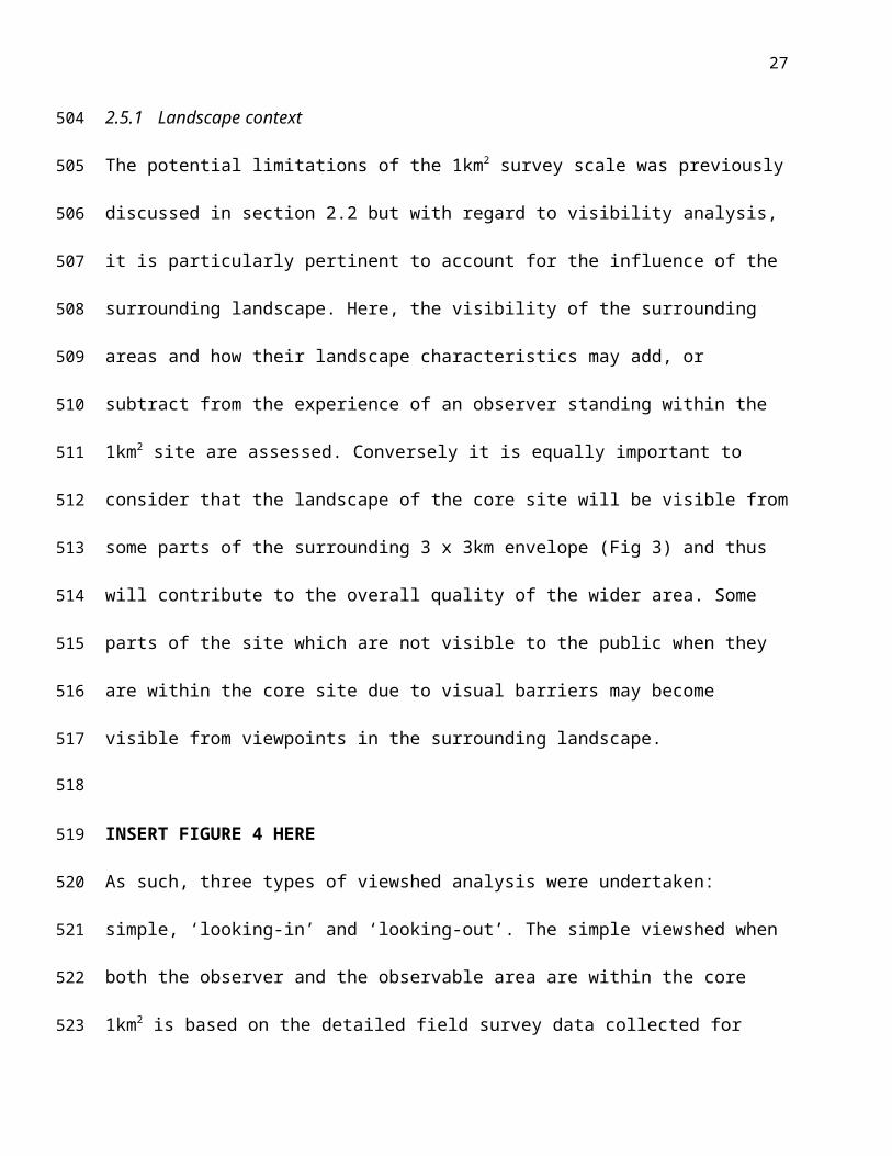
245
246
247
248
249
250
251
252
253
254
255
256
257
258
259
260
261

13
features such as waterfalls, wells and springs. Landscapes with the greatest area of standing
water and linear length of flowing water are rated highly. A final binary weighting is applied
where a portion or coast or sea is present within the site as coastal views are consistently valued
(Wheeler et al., 2012; Natural England, 2013).
2.4.3 VQI: Green Space
Vegetation is a significant factor in the evaluation of rural landscapes and evidence for the
importance of diverse habitats and greenery in positive landscape evaluations is extensive
(Kaplan & Kaplan, 1989; See Table S3). The GMEP landscape evaluation had the significant
advantage of being part of a wider monitoring programme which has a heavy focus on ecological
mapping (see Section 2.1). This gave us the opportunity to exploit detailed data on habitat and
species for all our study sites and to incorporate these fully within the landscape assessment.
Many of the parameters used are common in landscape assessments and include those relating to
woodlands and open space (Herzog & Bosley, 1992; Legge-Smith et al., 2012). Green space
parameters included: habitat richness, area of woodland, presence of single trees, species
diversity, hedgerow length and colour diversity (Table S3). Total hedgerow length is included in
this class as a separate parameter. Hedgerows are small, vertical wooded structures which
delineate field boundaries and can be varied in species and size. Many are old and species rich
and they are important landscape structures across the UK and other parts of Northern Europe
(Baudry et al., 2000; JNCC, 2012).
Colour variety is another factor found to have a positive influence on landscape quality ratings
(Howley et al., 2012; Schüpbach et al., 2016), particularly in the context of seasonal colour
changes - for instance spring blossom or autumnal leaf drop (Lindemann-Matthies & Bose, 2007;
Junge et al., 2015). A database of the indicator species for each broad habitat type recorded in
262
263
264
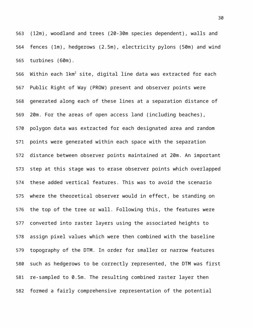
265
266
267
268
269
270
271
272
273
274
275
276
277
278
279
280
281
282
283
284

14
Wales, was populated with phenological information describing the main colour changes
associated with each species. This metric is not attempting to capture every shade of colour,
rather a relative measure of variety – for example, a deciduous woodland may have 3 colours
associated with it: green (leafburst in Spring), white (Summer flowering), yellow (Autumnal leaf
drop). The number of dominant colours associated with all the indicator species which define the
broad habitat type was then summed and linked in the GIS database to the mapped broad
habitats.
2.4.4 VQI: Human
The measures in this parameter class reflect human material encroachment, associated with
negative impacts on perception of landscape quality (Brush et al., 2000; Rechtman, 2013).
Landscape quality is perceived to decline as human influence increases both from the
encroachment of buildings but also through the imposition of homogenous landscape patterns
(Howley et al., 2012). It is acknowledged that some buildings can contribute significantly to the
perceived attractiveness of a particular view. In Wales, many of these exceptional buildings have
some legal protection and would be separately accounted for in the Historic group (see Section
2.4.5) but others would not so the metric does not capture this cultural component of the
landscape in full. For the purposes of this study, built land is classes as a negative. The area
covered by human-influenced land as well as that covered by buildings is included in this
category along with counts of spot utilities such as wind turbines, electricity pylons and other
visually-dominant vertical infrastructure. Roads are included here and the measures address not
only their presence but also evidence that suggests the bigger or busier the road is with traffic,
the more negatively it is perceived (Clay & Daniel, 2000; Garré et al., 2009). Since this class
285
286
287
288
289
290
291
292
293
294
295
296
297
298
299
300
301
302
303
304
305
306

15
contains only negative elements, higher scores are assigned for the absence or lack of such
elements (Table S4).
2.4.5 VQI: Historic
Preserving the heritage of the Welsh landscape and managing the CES associated with their
presence is an important component of the Glastir scheme. Historic and cultural assets can be
important for tourism, education and sense of place (Ashworth, 2008). In a long-settled
landscape such as Wales, cultural components such as churches, castles, stone walls or
prehistoric monuments shape the landscape view and character (Webley, 2004; Collier, 2013). In
the framework proposed by Ode et al. in 2008, they are highlighted as “indicators of historicity”
and were specifically included within our Welsh assessment. Within the VQI, the presences of
four main types of historic asset are assessed: the length of dry stone boundary walls, presence of
Scheduled Ancient Monuments (SAMs); presence of historic parks and gardens and the presence
of listed buildings of historic note (Table S5).
2.4.6 Weighting of the index parameter values
The five themes of the VQI presented in detail in Table 2 (and in detail in Tables S1 to S5)
represent 19 individual measures which are calculated for each 1km2 within the GMEP survey.
In their raw form, the contribution of these five themes is not equal due to differing number of
parameters within each theme. To ensure parity between the five components, the values within
each theme are therefore scaled and then weighted equally in the final index (Table S6 gives a
worked example). A sensitivity analysis was undertaken to evaluate the impact of changing these
weights between themes. This showed that the overall VQI remained stable when changes to
individual class weights remained in the range between 0.1-0.4 (compared to the 0.2 applied
here). By using equal weights, we assume that the different components of the landscape
307
308
309
310
311
312
313
314
315
316
317
318
319
320
321
322
323
324
325
326
327
328
329

16
contribute equally to overall visual landscape quality; these weights were agreed with the main
stakeholders as a reasonable compromise. Future refinement through the use of participatory
methods to determine the importance that different individuals assign to different categories
(Tenerelli et al., 2006) is a possibility but is not presented here (See S6 for details).
2.5 Development of the GMEP viewshed model
Accessibility is potentially a significant control on the visual quality of a landscape as it
determines which components can be seen by visitors. In an ecosystem services context –
whereby value is attached when a service is provided, if it cannot be accessed it is failing to
provide CES to visitors (Muhar, 2004). This has been recognised in work to evaluate the links
between service providing areas (SPA) and service benefiting areas (SBA) which make use of
landscape metrics (Syrbe & Walz, 2012) and GIS models to evaluate these spatial links (Ala-
Hulkko et al., 2016). Here, we take an immersive approach and evaluate the visual accessibility
of each 1km2 study to individuals moving through it or viewing it from the immediate
surroundings .In this second stage of the GMEP landscape assessment method we establish the
level of accessibility, as determined both in a physical sense through the presence of Public
Rights of Way (PROW) and also in a visual sense through the evaluation of the available view as
contained by topography or limited by infrastructure. The latter is assessed through the
application of 3D viewshed modelling which has found wide application in the evaluation of
visual impact (Wu et al., 2006; Joly et al., 2009; Garré et al., 2009). Although viewshed
modelling has rightly had its critics in the past (see Fisher, 1993 for example), the algorithms and
data available have improved markedly in recent times. Visual accessibility is rarely considered
in this context and there were three primary issues to be considered: scale, barriers to observation
and finally the represented observers.
330
331
332
333
334
335
336
337
338
339
340
341
342
343
344
345
346
347
348
349
350
351
352

17
2.5.1 Landscape context
The potential limitations of the 1km2 survey scale was previously discussed in section 2.2 but
with regard to visibility analysis, it is particularly pertinent to account for the influence of the
surrounding landscape. Here, the visibility of the surrounding areas and how their landscape
characteristics may add, or subtract from the experience of an observer standing within the 1km2
site are assessed. Conversely it is equally important to consider that the landscape of the core site
will be visible from some parts of the surrounding 3 x 3km envelope (Fig 3) and thus will
contribute to the overall quality of the wider area. Some parts of the site which are not visible to
the public when they are within the core site due to visual barriers may become visible from
viewpoints in the surrounding landscape.
INSERT FIGURE 4 HERE
As such, three types of viewshed analysis were undertaken: simple, ‘looking-in’ and ‘looking-
out’. The simple viewshed when both the observer and the observable area are within the core
1km2 is based on the detailed field survey data collected for GMEP. A ‘looking-in’ viewshed
where the observer points only fall within the surrounding 3 x 3km envelope area but the
observable area includes the core 1km2. Finally, the ‘looking-out’ viewshed where the observer
points are situated within the core but the observable area expands to include the full 3 x 3km
envelope (Fig 4). This computationally intensive approach has also been discussed by Carver
and Markieta (2012).
2.5.2 Barriers to observation
With viewshed analysis, any potential barriers to visibility must be taken into account; these
include buildings, treelines, solid boundaries such as walls plus the underlying terrain itself. The
353
354
355
356
357
358
359
360
361
362
363
364
365
366
367
368
369
370
371
372
373
374
375

18
inclusion of such barriers represents the different between the products of viewshed analyses
being regarded as “Zone of Visual Influence” (ZVI) versus “ Zone of Theoretical Visibility”
(ZTV). Within the context of development proposals the LI/IEMA(2013) recommend the use of
the latter, however, within the context of this project, it is the former ZVI which is most
appropriate. This is because i) we are surveying relatively small spatial areas ii) the detailed field
survey data to which we had access allows the inclusion of fences, walls, individual trees,
buildings and area of extensive woodlands as potential obstructions. The heights for these
elements derived from the survey data or collated from external data review.
2.5.3 Represented observers
We calculated separate viewsheds for four groups: i) pedestrians, ii) cyclists, iii) small vehicles
and vi) rail passengers. These represent the range of users of Welsh landscapes with each subject
to differing degrees of permitted access (Table 3). For each group (i-iv) an offset height was
attached to represent the approximate eyeline of the observer which was set at 1.7m for
pedestrians and cyclists, 1.5m for small vehicle passengers and 2.5m for rail passengers.
INSERT TABLE 3 HERE
2.6 Application of the GMEP viewshed model
Viewshed analysis was conducted within ESRI’s ArcGIS v10.2 using a 5m resolution Digital
Terrain Model as the baseline landscape complimented by field survey data to provide structural
detail. If not specifically recorded by the field surveyors, standard heights were assigned to
vertical features as follows: buildings (12m), woodland and trees (20-30m species dependent),
walls and fences (1m), hedgerows (2.5m), electricity pylons (50m) and wind turbines (60m).
376
377
378
379
380
381
382
383
384
385
386
387
388
389
390
391
392
393
394
395
396
19
Within each 1km2 site, digital line data was extracted for each Public Right of Way (PROW)
present and observer points were generated along each of these lines at a separation distance of
20m. For the areas of open access land (including beaches), polygon data was extracted for each
designated area and random points were generated within each space with the separation distance
between observer points maintained at 20m. An important step at this stage was to erase observer
points which overlapped these added vertical features. This was to avoid the scenario where the
theoretical observer would in effect, be standing on the top of the tree or wall. Following this, the
features were converted into raster layers using the associated heights to assign pixel values
which were then combined with the baseline topography of the DTM. In order for smaller or
narrow features such as hedgerows to be correctly represented, the DTM was first re-sampled to
0.5m. The resulting combined raster layer then formed a fairly comprehensive representation of
the potential visual barriers an observer might encounter from topographic variations to human
factors (Fig 5). Broad daylight conditions were assumed and the viewshed process was then
automated.
INSERT FIGURE 5 HERE
3 Results
The GMEP VQI has now been calculated for 150, 1km2 sites from the first two years of the field
survey. This gives us two pieces of information: firstly the rating itself – allowing us to compare
sites within years; secondly it provides our baseline from which to measure future change.
3.1 Results of the Visual Quality Index
Values for the Welsh VQI range from 0.296 to 0.681 with a mean of 0.460 and a median value of
0.459. The values exhibit a normal distribution, though low values are relatively rare (Fig 6).
397
398
399
400
401
402
403
404
405
406
407
408
409
410
411
412
413
414
415
416
417
418

20
When the VQI results are mapped, broad patterns are revealed. High values appear to be
concentrated in two of the three National Parks (NP), Snowdonia in the north and the Brecon
Beacons towards the south. Snowdonia NP and the associated coastal areas of the Lleyn
Peninsula immediately to the west and the island of Anglesey to the north-west contain many
sites with an overall VQI in the upper-quartile of the range. Likewise, the Brecon Beacons NP in
the south. Both these areas have long-standing landscape protection through their NP status. A
third cluster of upper-quartile values is shown in the central uplands of Wales. This area contains
the Cambrian Mountains, which is subject to an ongoing campaign to have it designated as an
‘Area of Outstanding Natural Beauty’ (CMS, 2008). Pembrokeshire Coast NP in the south-west
and the south coast of Wales as a whole tend to report VQI results in the lower-quartile of the
range. These areas tend to be more densely populated, containing the main conurbations of
Swansea, Cardiff and Port Talbot as well as landscapes with a long history of heavy industry
including coal mining and steel-making. In tandem with the more urban character of this part of
Wales, transport infrastructure in the form of railways and main roads are concentrated along the
coastal strip. Here, the coastal scenery is often visually appealing but often combined with
elements of the human landscape (such as buildings and roads) which tend to depress the VQI
index.
One characteristic of the VQI is that survey sites with different components of landscape quality
can share the same overall index. We believe this to be a strength rather than a weakness of the
approach as it can capture the variety of landscapes without judging one part of the whole to
necessarily be more important that another. Within our dataset, there are ten sites that all share
the same overall median value of 0.459 but this index is collated differently for each (S7).
419
420
421
422
423
424
425
426
427
428
429
430
431
432
433
434
435
436
437
438
439
440
441

21
INSERT FIGURE 6 HERE
3.2 Viewshed outputs
For each site, a maximum of 12 viewsheds can be generated (4 users x 3 scales) resulting in a
potential total of 1800 separate viewshed outputs. In reality this number was slightly lower as not
all sites had all four categories of user. Of the 150 1st and 2nd year sites, a total of 1253 viewshed
dataset were generated, each one a separate raster data layer of either 1 x 1km for the ‘simple’
and ‘looking in’ viewshed types or 3 x 3km for the ‘looking out’ viewshed. each with a cell size
of 0.5m . Each viewshed dataset is a single-band raster with values ranging from 0 (not visible
from any observer point) to a theoretical maximum determined by the number of observer points
located either in the 1km2 for the ‘simple’ and ‘looking out’ cases or the number of observer
points located in the surrounding 3km2 for the looking in viewshed (Fig 7). These outputs were
converted to a binary grid where non-visible cells were assigned 0; those visible from any
observer point were assigned 1. The percentage of the site which was visible could then be easily
calculated for comparison as well as mapped to identify which component parts of the study sites
were provided the view.
INSERT FIGURE 7 HERE
The viewshed model represents a theoretical maximum, assuming that all paths are fully
accessible. In reality, this is rare as footpaths can be disused where poorly signed or maintained.
Acquiring data on access is problematic; outputs presented here assume full access to ensure
model parity. For the 150 sites modelled so far, pedestrians could see on average 45% of the
1km2 site, and 40% of the 3 x 3km surroundings which is quite a high value and reflects the
density of the public rights of way network in Wales. Cyclists tend to have similar visual
accessibility to pedestrians as they can use some of the same paths as walkers (though not
442
443
444
445
446
447
448
449
450
451
452
453
454
455
456
457
458
459
460
461
462
463
464

22
designated footpaths which are restricted to walkers). Car drivers are more restricted; on average
their view covered 36% of the 1km2. For pedestrians 44% of the sites had visibility values >50%
meaning that more than half the landscape area was visible (Table 4).
INSERT TABLE 4 HERE
3.3 Combined outputs
Each site therefore has two index measures associated with it: the VQI which is a relative
measure of overall landscape quality represented by an index with values between 0 and 1 and
the ZVI (% of the site visible) which indicates public visual accessibility – where high quality
landscapes can be seen they provide a public benefit. When these two values are plotted (Fig. 8)
it is possible to identify candidate areas for possible improvement through management
interventions.
Two–step cluster analysis was undertaken in SPSS on these data which shows that is rare to get
high landscape values (VQI > 0.5) combined with high levels of public visual access (ZVI >
50%) with only 17.3% the 150 sites falling into this cluster. This is perhaps unsurprising as part
of the public access to sites is given through the road network which rates negatively in the index
(though note that footpaths and bridleways do not). A second cluster (8.7%) have the highest
VQI (>0.6) but only average levels of accessibility. The remoteness and lack of public
infrastructure which contribute to their high landscape ratings may mean that access is limited.
The largest group (53.3%) of sites have average VQI values, however, they may be providing a
wide range of ecosystem services (from farming, flood control) which may impact on their
aesthetic valuation by the public. The remainder (20.7%) have lower values according to the
VQI, though this does not mean that they are not valued or attractive in places. Those sites which
465
466
467
468
469
470
471
472
473
474
475
476
477
478
479
480
481
482
483
484
485
486

23
currently enjoy good visual access would certainly be a target for minor landscape interventions
to increase their landscape attractiveness to the public. The goal would be to have landscapes
resting within the upper right quadrant of the graph, so showing high landscape quality and high
accessibility. There are two ways to achieve this: either to improve accessibility to the sites by
opening up new rights of way, particularly to pedestrians, or to attempt to improve visual
landscape quality. The latter could be achieved by management of landscape features that impact
on landscape aesthetics – particularly the removal of human infrastructure such as masts or
pylons, the restoration of historic stone walls and the management of water features and
woodland.
INSERT FIGURE 8 HERE
4 Discussion
It is widely recognised that measuring CES is challenging (Hernández-Morcillo, et al., 2013)
often requiring a multi-disciplinary assessment to be truly comprehensive (Satz et al., 2013). One
approach advocated by Tallis et al., (2011), is to be specific about what service is being
quantified; in this paper, we focus on the visual aesthetics of landscape quality as one important
CES. It is clear that the quality of the landscape view has cultural, emotional and physical
importance to people, both residents and visitors (Kara, 2013). Therefore, measuring landscape
quality and the view that it provides, remains an important goal for ecosystem service assessment
(MEA, 2000; UKNEA, 2011). For many, it is not something that can or should be quantified; the
scenic beauty of nature undoubtedly has an existence value which is apart from our human need
to observe it. However, the groundwork laid by the MEA (2005) and subsequent national
accounting efforts (UK NEA, 2011, Potschin & Haines-Young, 2016) attest to its continuing
487
488
489
490
491
492
493
494
495
496
497
498
499
500
501
502
503
504
505
506
507
508

24
importance both in policy and management. Whilst there has been welcome development in the
theoretical aspects of landscape quality assessment to support this (Tveit et al., 2006; Ode et al.,
2008; Daily et al., 2009; Seppelt et al., 2012) and in the derivation of indicators to measure CES
(Church et al., 2011) the practical application to large-scale monitoring programmes has been
limited (but see Dramsted et al., 2006).
4.1 The contribution of GMEP to monitoring CES
In the GMEP approach to monitoring CES, we explicitly acknowledge the importance of
landscape aesthetics in peoples’ perception of the quality of a landscape (Daniel et al., 2012;
Hernández-Morcillo et al., 2013). Our method does not measure aesthetic quality directly
because this changes with timing, context and audience (Gobster et al., 2007). It is difficult to
control such variation and does not fit well with the need for a fixed baseline and measurement
of change – all of which are central to a long-term, wide scale monitoring programme like
GMEP. Our approach is to use measures which are tractable using GIS processing and those
supported by a wide range of evidence from published photographic preference studies that link
them to aesthetic enjoyment and high quality ratings (Joly, 2009; Legge-Smith et al., 2012). Our
choice of parameters (Table 2) which determine the VQI is necessarily partial and partly
determined by data availability and ease of measurement. However, the existing research
literature provided our theoretical base and considerable care has been taken in selection of these
parameters to ensure that monitoring is consistent over time (Tables S1 – S5). The 19 parameters
which are used in the GMEP VQI are therefore, acting as surrogates, capturing some component
of the aesthetic experience, but not all. A site with a high VQI may not be ‘prettier’ or more
scenic than one with a lower value but it does contain lots of the biophysical components of a
landscape which are linked to higher aesthetic ratings.
509
510
511
512
513
514515
516
517
518
519
520
521
522
523
524
525
526
527
528
529
530
531
532

25
In its summary form, the VQI is one value (0 -1) and relying on this metric to solely describe the
visual character of an individual landscape would be over-simplistic; understanding the
component parts of the index are equally important (Fig S7). It does however allow us to rank
the landscapes to identify groups of sites which tend to have lots of high quality features or vice-
versa (Fig. 7). This is how we recommend the index to be used. A key benefit is that it provides a
baseline from which change can be assessed. Degradation of landscape aesthetic quality is a
concern and often goes unnoticed by human viewers until considerable damage has occurred
(Fry et al., 2009). By measuring individual components of quality such as the length of
hedgerows or stone walls, degradation will be noticed before it has the potential to impact on
visual quality.
The GMEP landscape assessment approach is quantitative with an emphasis on spatially explicit
metrics (the VQI) and 3D modelling (the ZVI). Our method is designed to provide Welsh
policy-makers with baseline data on visual landscape quality as well as a quantitative means to
monitor change over short timescales. It has the additional benefit of sitting efficiently within the
wider landscape monitoring programme of GMEP and complements the existing qualitative
narratives within the LANDMAP dataset (Scott, 2002). The ecosystem service paradigm has a
clear focus on the delivery of economically quantifiable services to people (Fisher et al., 2008),
and within Wales, the ES approach has driven the design of the entire Glastir programme
(Emmett et al., 2013). Such emphasis on quantification is uncomfortable for many critics of
landscape assessment methods but it is one part of the solution to the consideration of such CES.
By combining such landscape quality measures with an assessment of their visual accessibility,
we believe our approach provides a method to indirectly quantify some of the key aesthetic
components of the CES provided by the landscape of Wales. The viewshed modelling allows us
533
534
535
536
537
538
539
540
541
542
543
544
545
546
547
548
549
550
551
552
553
554
555

26
to distinguish between the physical accessibility of a landscape as described by the PROW and
the visual accessibility of a landscape (what can actually be seen by the visitor when modified by
vegetation, topography and vertical structures) and provides us with a means to link the
measurable, physical components of the landscape to their potential aesthetic appeal (Muhar,
2004).
We acknowledge that this modelling has been enabled by access to coherent, quality-assessed
UK Ordnance Survey digital data and informed by fine-scale habitat survey which provides the
necessary detail to attempt such an analysis (Maskell et al., 2008; Emmett et al., 2013,2014).
Dependence on fine-scale data of this type could limit its wider application elsewhere, but the
combination of detailed field-survey and complete digital topographic data certainly is possible
for many smaller studies.
In reviewing the 19 parameters that make up the VQI (Table 2), 10 could be calculated using
freely available national or global datasets. These include the TRI which requires a digital terrain
model (DTM) as input and could be calculated using products like the Shuttle Radar Topography
Mission (STRM) which is freely available from sites such as the Kings College London
Geoportal (Jarvis, 2004). The area of standing water, length of flowing water, presence of coasts,
quarries and utilities as well as road data are standard features of many global boundary datasets
(Natural Earth, 2016). In addition, global datasets such as Globcover (Arino et al., 2012) or
country-level landcover datasets such as Corine (EEA, 2006) can be used to extract the area of
woodland, human-influenced land and buildings. Habitat richness can also be calculated from
such remotely sensed landcover datasets. Some of the historic parameters used in the VQI are
UK-specific but easily substituted with country-level data on designated sites whilst the UK-
556
557
558
559
560
561
562
563
564
565
566
567
568
569
570
571
572
573
574
575
576
577
27
specific parameters relating to stone walls and hedgerows would need replacing with cultural
landscape features of local relevance.
Due to the restricted public access to land in Wales, our viewshed analysis had to incorporate an
additional layer of complexity which modelled the sight-lines from public routes such as
footpaths and roads. In other countries, access is more open and here the modelling could be
simplified to just account for topography (derived from a DTM) and significant vertical
infrastructure such as woodlands or buildings. The latter are readily available in existing spatial
datasets. Therefore, the method is transferable to other data-scarce locations and the approach
which combines landscape quality metrics with viewshed analysis could be adopted, albeit at a
coarser spatial scale.
4.2 Caveats
Any biophysically-based assessment of landscape quality will inevitably be partial and the work
presented in this paper is not attempting to answer every criticism of the component approach; a
number of caveats apply. Firstly, with respect to the scale of analysis undertaken within GMEP,
most would recognise that the 1km2 study sites are too small in themselves to be considered as
true landscape studies. The scale of the detailed data collection was actually set by the wider
biophysical monitoring being undertaken within the GMEP as a whole and so a compromise was
required. A 1km2 study site imposed an artificial barrier on our viewshed study and was
problematic for a landscape evaluation. We therefore, extended the landscape viewshed
component of the method out to include the 3 x 3km area within which the sites were placed.
This allowed us to take full advantage of the detailed field survey within the study sites to create
a landscape quality dataset of rigour whilst incorporating the longer views within the viewshed
578
579
580
581
582
583
584
585
586
587
588589
590
591
592
593
594
595
596
597
598
599
600

28
analysis. Of course, the boundaries can always be extended further, but the scale chosen for this
work represented a balance between the demands of the computation of such detailed 3D
modelling (Carver & Markieta, 2012), the experience of the person within a landscape and the
desire to make the model meaningful in the Welsh context. Inevitably a compromise has to be
made between detail and spatial extent and the decision about scale will be influenced by the
context of the landscape under evaluation. For this study, the 3 x 3km final study area reflected
the grain of the Welsh landscape – in other more open conditions, both the scale of the input data
and the extent of the study sites may need adjustment.
Secondly, we do not explicitly include landscape pattern metrics in the list of parameters that
define the VQI. Metrics such as shape, diversity, patch density are common in landscape ecology
as indicators of biological function (Hargis et al.,1998; Kupfer, 2012) and they have been used in
landscape aesthetic assessments (Frank et al., 2013). Many of these spatial metrics are however,
prone to edge and scale effects and within a 1km2 the impact of the site “edge” on these metrics
would be problematic. Some of the parameters that are measured in the VQI (such as the area of
woodland, length of rivers and roads and the diversity of habitat types) already capture some of
the spatial variation that these metrics describe.
Thirdly, the assignment of class values as described in Tables S1 – S5 represents a fairly simple
deterministic approach and could be described as arbitrary in that they represent equal divisions
across the parameter ranges. These have partly been derived for ease of understanding by the
users of the metric, rather than based on a statistical model but the raw data to which these
classes are applied is also kept as a measure for future comparison of change. The weightings
between the categories have been subject to a sensitivity analysis which indicates that the VQI is
relatively stable when weightings operate in the 0.1-0.4 range; extremes inevitably impact it
601
602
603
604
605
606
607
608
609
610
611
612
613
614
615
616
617
618
619
620
621
622
623

29
significantly (see S6). Therefore, our decision to use equal weightings is sound as a baseline for
monitoring purposes.
Fourthly, the viewshed modelling undertaken to calculate the ZVI assumes that all PROW are
fully accessible, so the visual accessibility outputs represent the theoretical maximum. Incidental
monitoring was undertaken by the GMEP surveyors who used these paths during the field survey
programme. These data showed that on average only 66% of the paths were fully open,
accessible and clearly signed, though there was considerable variation present. Such closures
would impact on the output viewshed for an individual site, though topography and vegetation
remain the main determinants of the result. In other countries where public access is not confined
to such a defined PROW network (i.e where access is effectively open) this may not be an issue.
Where possible, these data should be available or collected systematically as part of the field
programme and in future years GMEP will account for this explicitly.
4.3 Contribution to this Special Issue (SI) – Putting Ecosystem Services into Practice
The topic of this SI is concerned directly with the application of CES knowledge, tools and
methods within the public sphere to ensure sustainable land management. Our work in Wales is
one example of this type of application. Within the Glastir programme, the Welsh Government
has a land management framework designed to sustain and improve the rural landscapes of
Wales. One component of ES identified by the policy makers is that of landscape quality, a
recognised CES (Haines-Young & Potschin, 2013; Frank et al., 2013) With its national scope
(300 sites to be resurveyed every four years), the Glastir monitoring framework is ambitious both
spatially, in its desire to act as a national monitoring scheme but also temporally in its
longitudinal re-survey. Such ambition requires pragmatic solutions to assessment that can
624
625
626
627
628
629
630
631
632
633
634
635
636637
638
639
640
641
642
643
644
645
646
30
quantify CES in an objective fashion and so enable changes to be detected early. The desire of
such monitoring is not only to understand the stock or ‘supply’ (Tratalos et al., 2016) of CES in
the Welsh landscape but also to assess whether the CES are diminishing over time and so require
improvement. Payments to landowners provide direct means to target such activity, either
through the physical management of habitats such as woodlands; the physical protection of
heritage sites or the provision of new forms of public access to the countryside. All these
activities may secure CES for residents and visitors alike. The VQI metric helps to identify those
landscapes where tangible improvements are required and when combined with the ZVI created
by the viewshed modelling, these specific land management interventions can be targeted at a
site level to maintain and improve CES provision to the public.
5 Conclusion
We acknowledge that attempting to quantify landscape quality using physical indicators
inevitably provides only a partial answer to a complex question (Satz et al., 2013). The rejection
of such approaches in the 1970s and 1980s reflected an over-reliance on simplistic tick-lists and
helped to promote a more holistic response in the form of character assessment (Swanwick,
2003; Tudor, 2014). However, by themselves, such broad narratives of landscape type are not
necessarily of practical use to policy makers for monitoring purposes. For reporting, government
departments often require quantitative measures which can show trends over time – however
partial they may be. By interrogating the landscape aesthetics literature and using well-accepted
parameters with some common evidence of links to people’s preferences in landscape quality,
we have attempted to adopt those measures which capture part of this complexity. With
647
648
649
650
651
652
653
654
655
656
657
658
659
660
661
662
663
664
665
666
667
31
appropriate fine-tuning to account for important cultural differences in landscape perception and
worth, the method presented here could be adapted to other landscape monitoring programmes.
668
669
670

32
6 References
Ala-Hulkko, T., Kotavaara, O., Alahuhta, J., Helle, P, Hjort, J. 2016. Introducing accessibility
analysis in mapping cultural ecosystem services. Ecological Indicators, 66: 416-427.
Arino, O., Perez, R., Julio, J., Kalogirou, V., Bontemps, S., Defourny, P., Van Bogaert, E., 2012.
Global Land Cover Map for 2009 (Globcover 2009) European Space Agency (ESA) &
Université catholique de Louvain (UCL) doi: 10.1594/PANGAEA.787668
Arriaza, M., Cañas-Ortega, J. F., Cañas-Madueño,Ruiz-Aviles, P., 2004. Assessing the visual
quality of rural landscapes. Landscape and Urban Planning, 69(1):115–125.
Ashworth, G., 2008. In search of the Place-identity Dividend: Using Heritage Landscapes to
Create Place Identity. Chapter 13 in Eyles, J & Williams, A., (Eds.) Sense of Place, Health
and Quality of Life. Ashgate Publishing Ltd: Aldershot, UK.
Baudry, J., Bunce, R.G.H., Burel, F., 2000. Hedgerows: An international perspective on their
origin, function and management. Journal of Environmental Management, 60(1):7-22.
Benton, T. G., Vickery, J. A., Wilson, J. D., 2003. Farmland biodiversity: is habitat
heterogeneity the key? Trends in Ecology and Evolution, 18(4):182-188..
Brush, R., Chenoweth, R. E., Barman, T., 2000. Group differences in the enjoyability of driving
through rural landscapes. Landscape and Urban Planning, 47(1-2):39–45.
671
672
673
674
675
676
677
678
679
680
681
682
683
684
685
686
687

33
Bunce, R. G. H., Barr, C. J, Gillespie, M. K., Howard, D. C.,1996. The ITE Land Classification:
providing an environmental stratification of Great Britain. Environmental Monitoring nad
Assessment, 39: 39-46.
Carey, P. D. Wallis, S., Chamberlain, P. M., Cooper, A., Emmett, B. A., et al., 2008. Countryside
Survey: UK results from 2007. Final report http://nora.nerc.ac.uk/5191/1/N005191CR
%20UK%20Results.pdf
Carver, S., & Markieta, M., 2012. No High Ground: visualising Scotland's renewable energy
landscapes using rapid viewshed assessment tools. Proceedings of GISRUK 2012,
Lancaster University UK.
Chiesura, A & de Groot, R., 2003. Critical natural capital: a socio-cultural perspective.
Ecological Economics,44: 219-231.
Church, A., Burgess, J., Ravenscroft, N., Bird W., et al., 2011 Cultural Services: UK National
Ecosystem Assessment. UNEP-WCMC, Cambridge, pp 633-692.
Clay, G.R. & Daniel, T.C., 2000. Scenic landscape assessment: the effects of land management
jurisdiction on public perception of scenic beauty. Landscape and Urban Planning, 49(1-
2):1–13.
CMS (2008) The Cambrian Mountains Society . Cambrian Mountains - The Heart of Wales.
Developing a Strategy for a Sustainable Future. Available from cambrian-mountains.co.uk
Collier, M. 2013. Field boundary stone walls as exemplars of 'novel' ecosystems. Landscape
Research, 38(1): 141-150.
688
689
690
691
692
693
694
695
696
697
698
699
700
701
702
703
704
705
706
707

34
Crofts, R. S., 1975. The Landscape Component Approach to Landscape Evaluation.Transactions
of the Institute of British Geographers, 66: 124-129.
Dakin, S., 2003. There’s more to landscape than meets the eye: towards inclusive landscape
assessment in resource and environmental management. The Canadian Geographer/Le
Geographe Canadien, 47(2):185–200.
Daily, G. C., Polasky, S., Goldstein, J., Kareiva, P. M., et al., 2009. Ecosystem services in
decision making: time to deliver. Frontiers in Ecology and Environment, 7:21-28.
Daniel, T. C., Muhar, A., Arnberger, A., Anzar, O., et al., 2012. Contributions of cultural
services to the ecosystem services agenda. PNAS, 109(2): 8812-8819.
Dramstad, W.E., Sundli-Tveit, M., Fjellstad, W. J., Fry, G. L. A., 2006. Relationships between
visual landscape preferences and map-based indicators of landscape structure. Landscape
and Urban Planning, 78(4):465–474.
Emmett, B.A., 2013. An integrated ecological, social and physical approach to monitoring
environmental change and land management effects: the Wales Axis II Monitoring and
Evaluation Programme. Aspects of Applied Biology, 118.
Emmett, B. A., and the GMEP team, 2014. Glastir Monitoring & Evaluation Programme.First
Year Annual Report to Welsh Government (Contract reference: C147/2010/11).
NERC/Centre for Ecology & Hydrology (CEH Project: NEC04780),pp. 442.
EEA , 2006. European Environment Agency, Corine Land cover data 2006. Available from
www.eea.europa.eu/data-and-maps/data.
708
709
710
711
712
713
714
715
716
717
718
719
720
721
722
723
724
725
726
727
35
Fahrig, L., Baudry, J., Brotons, L., Burel, F. G., Crist, T. O., et al., 2011. Functional landscape
heterogeneity and animal biodiversity in agricultural landcapes. Ecology Letters, 14:101-
112.
Fisher, P. 1993. Algorithm and implementation uncertainty in viewshed analysis. International
Journal of Geographical Information Systems, 7(4):331-347.
Fisher, B., Turner, K., Zylstra, M., Brouwer, R., de Groot, R., et al., 2008. Ecosystem services
and economic theory: Integration for policy-relevant research. Ecological Applications,
18(8):2050–2067
Fletcher, R., Baulcomb, C., Hall, C., Hussain, S., 2014. Revealing marine cultural ecosystem
services in the Black Sea. Marine Policy, 50(A): 151-161.
Frank, S., Fürst, C., Koschke, L., Witt, A., Makeschin, F. 2013. Assessment of landscape
aesthetics - Validation of a landscape metrics-based assessment by visual estimate of scenic
beauty. Ecological Indicators, 32: 222-231.
Fry, G., Tveit, M. S., Ode, Ä, Verlarde, 2009. The ecology of visual landscapes: Exploring the
conceptual common ground of visual and ecological landscape indicators. Ecological
Indicators, 9(5): 933-947.
García-Llorente, M. Martín-López, B., Ineiesta-Arandia, I., López-Santiago, C. A., et al., 2012.
The role of multi-functionality in social preferences toward semi-arid rural landscapes: An
ecosystem service approach. Environmental Science & Policy, 19-20:136–146.
728
729
730
731
732
733
734
735
736
737
738
739
740
741
742
743
744
745
746
36
Garré, S., Meeus, S.,Gulinck, H., 2009. The dual role of roads in the visual landscape: A case-
study in the area around Mechelen (Belgium). Landscape and Urban Planning, 92(2):125–
135.
Geijzendorffer, I. R., & Roche, P. K., 2013. Can biodiversity monitoring schemes provide
indicators for ecosystem services? Ecological Indicators, 33: 148-157.
Gobster, P.H., Nassauer, J. I., Daniel, T. C., Fry, G., 2007. The shared landscape: what does
aesthetics have to do with ecology? Landscape Ecology, 22: 959-972.
Gómez-Baggethun, E., de Groot, R., Lomas, P. L., Montes, C., 2010. The history of ecosystem
services in economic theory and practice: From early notions to markets and payment
schemes. Ecological Economics, 69(6):1209–1218.
Gruehn, D., & Roth, M., 2010. Landscape preference study of agricultural landscapes in
Germany. Journal of Landscape Ecology, 67-78.
Gyllin, M. & Grahn, P., 2015. Semantic Assessments of Experienced Biodiversity from
Photographs and On-Site Observations - A Comparison. Environment and Natural
Resources Research 5(4):46-62
Haines-Young, R. & Potschin, M., 2013. Common International Classification of Ecosystem
Services (CICES). Consulation on version 4, August December 2012. EEA Framework
Contract No EEA/IEA/09/003 www.cices.ac.uk
Hargis, C. D., Bissonetter, J. A.,David, J. L. 1998. The behavior of landscape metrics commonly
used in the study of habitat fragmentation. Landscape Ecology, 13: 167-198.
747
748
749
750
751
752
753
754
755
756
757
758
759
760
761
762
763
764
765
766

37
Hernández-Morcillo, M., Plieninger, T., Bieling, C., 2013. An empirical review of cultural
ecosystem service indicators. Ecological Indicators, 29: 434-444.
Herzog, T.R. & Bosley, P.J., 1992. Tranquillity and preference as affective qualities of natural
environments. Journal of Environmental Psychology, 12(2):115–127.
Hoechstetter, S., Walz, U., Dang, L.H., Thinh, N.X., 2008. Effects of topography and surface
roughness in analyses of landscape structure – A proposal to modify the existing set of
landscape metrics. Landscape Online, 3:1–14.
Howley, P., Donoghue, C. O., Hynes, S., 2012. Exploring public preferences for traditional
farming landscapes. Landscape and Urban Planning, 104(1):66–74.
Jarvis, A., Rubiano, J., Nelson, A., Farrow, A., Mulligan, M., 2004. Practical use of STRM data
in the tropics - Comparisons with digital elevation models generated from cartographic
data. CIAT working document No. 198 available at
http://srtm.csi.cgiar.org/PDF/Jarvis4.pdf.
JNCC, 2012. Joint Nature Conservation Committee and Defra: UK Post-2010 Biodiversity
Framework, Available on line: http://jncc.defra.gov.uk/pdf/UK_Post2010_Bio-Fwork.pdf
Joly, D.,Brossard, T., Cavailhès, J., Hilal, M., et al., 2009. A Quantitative Approach to the Visual
Evaluation of Landscape. Annals of American Geographers, 99(2): 292-308.
Jones, M., 2007. Seasonality and Landscape in Northern Europe: An Introductory Exploration.
Chapter 2 in Palang et al., (Eds.) Seasonal Landscapes. Landscape Series Vol 7. Springer:
Dordrecht. 257pp.
767
768
769
770
771
772
773
774
775
776
777
778
779
780
781
782
783
784
785
786

38
Jorgensen, A. & Anthopoulou, A. 2007. Enjoyment and fear in urban woodlands - does age
make a difference? Urban Forestry and Urban Greening 6: 267-278.
Junge, X., Schüpbach, B.,Walter, T., Schmid, B., Lindemann-Matthies, P., 2015. Aesthetic
quality of agricultural landscape elements in different seasonal stages in Switzerland.
Landscape and Urban Planning,133: 67-77.
Kaplan, R & Kaplan, S., 1989. The Experience of Nature. Cambridge University Press:
Cambridge, UK.
Kaltenborn, B. P & Bjerke, T., 2002. Associations between Landscape Preferences and Place
Attachment: A study in Røros, Southern Norway. Landscape and Urban Planning, 133: 67-
77.
Kara, B., 2013.Landscape Design and Cognitive Psychology. Procedia - Social and Behavioral
Sciences 82 ( 2013 ) 288 – 291.
Kellert, S. R., & Wilson, E. O., 1993. The Biophilia Hypothesis. Island Press: Washington DC.
Kienast, F., 1993. Analysis of historic landscape patterns with a Geographical Information
System - a methodological outline. Landscape Ecology, 8(2):103–118.
Kienast, F., Degenhardt, B., Weilenmann, B., Wäger, Y., Buchecker, M., 2012. GIS-assisted
mapping of landscape suitability for nearby recreation. Landscape & Urban Planning 105
(4): 385–399,
Kish, L. 1990. Rolling Samples and Censuses. Survey Methodology, 16: 63-79.
787
788
789
790
791
792
793
794
795
796
797
798
799
800
801
802
803
804
805

39
Klein, L. R., Hendrix, W. G., Lohr, V. I., Kaytes, J. B, et al., 2015. Linking ecology and
aesthetics in sustainable agricultural landscapes: Lessons from the Palouse region of
Washington, U.S.A. Landscape and Urban Planning, 134: 195-209.
Kupfer, J. A. 2012. Landscape ecology and biogeography: Rethinking landscape metrics in a
post-FRAGSTATS landscape. Progress in Physical Geography,36(3): 400-420.
Landscape Institute and Institute of Environmental Management & Assessment, 2013.
Guidelines for Landscape and Visual Impact Assessment, 3rd Edition. Routledge: London,
pp170.
La Rosa, D., Spyra, M., Inostroza, L. 2016. Indicators of Cultural Ecosystem Services for urban
planning; A review. Ecological Indicators, 61(1): 74-89.
Lewis, P.H., 1964. Quality corridors for Wisconsin. Landscape Architecture 54(2):100-107.
Lewis, P. H. 1996. Tomorrow by Design. A Regional Design Process for Sustainability. New
York, NY: John Wiley & Sons.
Lindemann-Matthies, P. & Bose, E. 2007, Species richness, structural diversity and species
composition in meadows created by visitors of a botanical garden in Switzerland.
Landscape and Urban Planning, 79: 298-307.
Legge-Smith, E., Bishop, I. A., Williams, K.J.H., Ford, R. M.,2012. Scenario Chooser: An
interactive approach to eliciting public landscape preferences. Landscape and Urban
Planning, 106(3):230–243.
Lynch, K. 1960 The Image of the City. Cambridge MA: The MIT Press.
806
807
808
809
810
811
812
813
814
815
816
817
818
819
820
821
822
823
824
825
40
Maskell, L.C. Norton, L. R., Smart, S. M., Carey, P.D, et al., 2008. CS Technical Report No.1/07
Field Mapping Handbook, NERC Centre for Ecology and Hydrology, 2008.
MEA, 2005. Millennium Ecosystem Assessment Ecosystems and Human Well Being: Current
State and Trends Assessment, Volume 1. Island Press: London.
Milcu, A. I., Hanspach, J., Abson, D., Fischer, J., 2013. Cultural Ecosystem Services: A
Literature Review and Prospects for Future Research, Ecology and Society, 18(3):44.
http://dx.doi.org/10.5751/ES-05790-180344
Mononen, L., Auvinen, A-P., Ahokumpu, A-L., Rönkä, M., et al., 2016. National ecosystem
service indicators: Measures of social-ecological sustainability. Ecological Indicators, 61:
27-37.
Moore, T.L. C & Hunt, W. F. 2012. Ecosystem service provision by stormwater wetlands and
ponds - a means for evaluation? Water Research 46(20): 6811-6823.
Morton, D. Rowland, C., Wood, C., Meek, L., et al., 2011. Final Report for LCM2007 - the new
UK land cover map. Countryside Survey Technical Report No 11/07. NERC/Centre for
Ecology & Hydrology, 112pp.
Motloch, J. L., 2001. Introduction to Landscape Design, 2nd Edition. John Wiley & Sons:
Chichester.
Muhar, A., 2004. Quantification of Public Access to the Landscape: Methods and Case Studies.
In Open Space - People Space: An International Conference on Inclusive Environments.
826
827
828
829
830
831
832
833
834
835
836
837
838
839
840
841
842
843
844
41
Nasar, J. L. & Li, M. 2004. Landscape mirror: the attractiveness of reflecting water.Landscape
and Urban Planning, 66:233-238.
Nassauer, J. I., 1995. Messy ecosystems, orderly frames. Landscape Journal, 14: 161-170.
NAW, 2011. National Assembly for Wales - An Introduction to Glastir and other UK agri-
environment programmes. Members Research Services, February 2011.
Natural Earth, 2016. Natural Earth large scale vector data 1:10m. Available from
www.naturalearthdata.com/downloads. Accessed October 2016.
Natural England, 2013. Monitoring of Engagement with the Natural Environment. Annual
Report from the 2012-13 Survey, Natural England: Peterborough, UK.
National Character Areas, Natural England 2016. Natural England National Character Area
Profiles. Available from http://publications.naturalengland.org.uk/category/587130
Accessed Feb 2016.
NRW, Natural Resources Wales, 2013. LANDMAP Methodology: Guidance for Wales.
Monitoring Methodology.
Norton, L. R., Inwood, H., Crowe, A., Baker, A., 2012.Trialling a method to quantify the
'cultural services' of the English landscape using Countryside Survey data. Land Use Policy,
29(2):449-455.
Norton, L. R., Greene, S., Scholefield, P., Dunbar, M., 2016. The importance of scale in the
development of ecosystem service indicators? Ecological Indicators, 61: 130-140.
845
846
847
848
849
850
851
852
853
854
855
856
857
858
859
860
861
862
863

42
Ode, Ä. Tveit, M. S., Fry, G., 2008. Capturing Landscape Visual Character Using Indicators:
Touching Base with Landscape Aesthetic Theory. Landscape Research, 33(1):89-117.
Ode, Å. & Miller, D., 2011. Analysing the relationship between indicators of landscape
complexity and preference. Environment and Planning - Part B, 38(1):24–40.
Portman, M.E., 2013. Ecosystem services in practice: Challenges to real world implementation
of ecosystem services across multiple landscapes – A critical review. Applied Geography,
45:185–192.
Potschin, M., & Haines-Young, R., 2016. Defining and measuring ecosystem services. In
Potschin, M., Haines-Young, R., Fish, R., and Turner R. K., (eds.) Routledge Handbook of
Ecosystem Services. Routledge, London & NY: 25-44.
Rechtman, O., 2013. Visual Perception of Agricultural Cultivated Landscapes: Key Components
as Predictors for Landscape Preferences. Landscape Research, 38(3):273–294.
Riley, S.J., DeGloria, S. D., Elliot, R., 1999. A terrain ruggedness index that quantifies
topographic heterogeneity. Intermountain Journal of Sciences, 5(1-4):23–27.
Rogge, E.,Nevens, F., Gulinck, H., 2007. Perception of rural landscapes in Flanders: Looking
beyond aesthetics. Landscape and Urban Planning, 82: 159-174.
Satz, D., Gould, R. K., Chan, K.M.A., Gnerry, A., et al., 2013. The Challenges of Incorporating
Cultural Ecosystem Services into Environmental Assessment. Ambio 42,: 675-684.
864
865
866
867
868
869
870
871
872
873
874
875
876
877
878
879
880
881

43
Schirpke, U., Tasser, E. & Tappeiner, U., 2013. Predicting scenic beauty of mountain regions.
Landscape and Urban Planning, 111:1–12.
Schüpbach, J., Junge, X., Lindemann-Matthies, P., Walter, T., 2016. Seasonality, diversity and
aesthetic valuation of landscape plots An integrative approach to assess landscape quality
on different scales. Land Use Policy, 53: 27-35.
Scott, A., 2002. Assessing Public Perception of Landscape: The LANDMAP experience.
Landscape Research, 27(3):271–295.
Selman, P & Swanwick, C. 2009. On the meaning of Natural Beauty in Legislation. Landscape
Research, 35(1):3-26.
Seppelt, R., Fath, B., Burkhard, B., Fisher, J. L., et al., 2012. Form follows function? Proposing a
blueprint for ecosystem service assessments based on reviews and case studies. Ecological
Indicators, 21: 145-154.
Sherrouse, B. C., Clement, J. M., Semmens, D. J., 2011. A GIS application for assessing,
mapping and quantifying the social values of ecosystem services. Applied Geography, 31:
748-760.
Simpson, R. D. 2011. The "Ecosystem Framework": A Critical Assessment. Ecosystem Services
Economics (ESE) Working paper number 5. Division of Environmental Policy
Implementation, UNEP, January 2011.
Stamps, A., 2004. Mystery, complexity, legibility and coherence: A meta-analysis. Journal of
Enviornmental Psychology, 24(1): 1-16.
882
883
884
885
886
887
888
889
890
891
892
893
894
895
896
897
898
899
900
901
44
Stewart, P.J. & Strathern, A., 2003. Introduction/Epilogue. In P. J. Stewart & A. Strathern, eds.
Landscape, Memory and History: Anthropological perspectives. Pluto Press, London.
Syrbe, R., & Walz, U. 2012. Spatial indicators for the assessment of ecosystem services:
Provding, benefiting and connecting areas and landscape metrics. Ecological Indicators 21:
80-88.
Swanwick, C., 2003.The Assessment of Countryside and Landscape Character in England: An
Overview. In “From Global to Local: Developing Comprehensive Approaches To
Countryside and Nature Conservation”. Eds. Bishop, K. and Phillips, A. Earthscan, London.
109-124
Tallis, H., S.E. Lester, M. Ruckelshaus, M. Plummer, K. McLeod, A. Guerry, S. Andelman,
M.R. Caldwell, et al. 2011. New metrics for managing and sustaining the ocean’s bounty.
Marine Policy 36: 303–306.
TEEB (2010) The Economics of Ecosystems and Biodiversity. Ecological and Economic
Foundations. Pashpam Kumar (Ed.) Earthscan: London & Washington. Available from
www.teebweb.org.
Tenerelli, P, Demšar, U., Luque, S., 2016. Crowdsourcing indicators for cultural ecosystem
services: A geographically weighted approach for mountain landscapes. Ecological
Indicators, 64: 237-248.
902
903
904
905
906
907
908
909
910
911
912
913
914
915
916
917
918
919
45
Tengberg, A., Fredholm, S., Eliasson, I., Knez, I., Saltzman, K., Wetterberg, O., 2012. cultural
ecosystem services provided by landscapes: Assessment of heritage values and identity.
Ecosystem Services, 2: 14-26.
Tian, Y., Jim, C. Y., Wang, H., 2014. Assessing the landscape and ecological quality of urban
green spaces in a compact city. Landscape and Urban Planning, 121:97–108.
Tratalos, J. A., Haines-Young, R., Potschin, M., Fish, R., Church, A., 2016. Cultural ecosystem
services in the UK: Lessons on designing indicators to inform management and policy.
Ecological Indicators, 61: 63-73.
Tudor, C., 2014. An Approach to Landscape Character Assessment. Natural England Report
NE579. ISBN-978-78367-141-0.
Tveit, M. S, Ode, Ä, Fry, G., 2006. Key concepts in a framework for analysing visual landscape
character. Landscape Research, 31(3): 229-255.
Tveit, M.S., 2009. Indicators of visual scale as predictors of landscape preference; a comparison
between groups. Journal of Environmental management, 90(9):282–288.
UK National Ecosystem Assessment, 2011. The UK National Ecosystem Assessment: Synthesis
of the Key Findings. UNEP-WCMC, Cambridge., 87pp.
Uuemaa, E., Antrop, M., Roosaare, J., Marja, R., Mander, U. 2009. Landscape metrics and
Indices: An Overview of their Use in Landscape Research. Living Reviews in Landscape
Research, 3(1): 1-28.
920
921
922
923
924
925
926
927
928
929
930
931
932
933
934
935
936
937
938
46
van den Berg, A. E., & Koole, S. L. 2006. New wilderness in The Netherlands: An investigation
of visual preferences for nature development landscapes. Landscape and Urban Planning,
78(4): 362-372.
van der Jagt, A.P.N., Craig, T., Anable, J., Brewer, M.J., Pearson, D. G. 2014. Unearthing the
picturesque: The validity of the preference matrix as a measure of landscape aesthetics.
Landscape and Urban Planning, 124: 1-13.
Vizzari, M., 2011. Spatial modelling of potential landscape quality. Applied Geography,
31(1):108–118.
Völker, S. & Kistemann, T., 2011. The impact of blue space on human health and well-being -
salutogenetic health effects of inland surface waters: a review. International Journal of
Hygiene and Environmental Health. 214(6): 449-460.
Webley, P., (Ed.) 2004. Dry Stone Walling Techniques and Traditions. Dry Stone Walling Association:
Cumbria UK
Wheeler, B.W., White, M., Stahl-Timmins, W., Depledge, M.H., 2012. Does living by the coast
improve health and wellbeing? Health & Place, 18(5):1198–1201.
Wu, Y., Bishop, I., Hossain, H., Sposito, V., 2006. Using GIS in landscape visual quality
assessment. Applied GIS, 2(3).18.1-18.20.
Wynne-Jones, S., 2015. Collecting payments for ecosystem services and agri-environmental
regulation: An analysis of the Welsh Glastir scheme. Journal of Rural Studies, 31: 77-86.
939
940
941
942
943
944
945
946
947
948
949
950
951
952
953
954
955
956
957

47
Yang, D., Luo, T., Lin, T., Qui, Q., Luo, Y., (2014) Combining Aesthetic with Ecological Values
for Landscape Sustainability. PLoS One. 2014; 9(7): e102437
958
959
960

48
Acknowledgements
This project was funded by the Welsh Government and the European Commission via the Axis II
component of the Rural Development Plan for Wales 2007-2013 (Contract reference:
C147/2010/11) and forms part of the wider Glastir Monitoring and Evaluation Programme
(GMEP) which is led at the NERC Centre for Ecology and Hydrology by Professor Bridget
Emmett and managed by Bronwen Williams (CEH Project: NEC04780) and James Skates
(Welsh Government). We acknowledge the contribution of all our project partners in GMEP to
the development of these ideas and to the provision of data on which these models are built. We
thank Agne Prochorskaite, Eneko Garro-Arroyo, and Jordan White for their contribution to the
landscape work package of GMEP. Finally, we acknowledge our reviewers for their detailed and
constructive comments which helped to improve this paper.
961
962
963
964
965
966
967
968
969
970
971

49
List of Figures
Figure 1: Theoretical framework for the evaluation of landscape quality.
Figure 2: Large areas of Wales are mountainous (areas shaded in grey are >300m) and it has a
varied and valued coastline. GMEP is designed to sample the full range of Welsh landscapes and
the samples are situated across the entire country – the site locations are confidential but the map
shows areas on a 5km grid which contain 1 or more of the 150 1km2 survey sites.
Figure 3: The landscape envelope composed of eight 1km2 cells surrounding the core study site,
which provides context to the core 1km2 sites.
Figure 4: Three different scales of viewshed model developed with the concept of “borrowed
view” in mind, wherein the background scenery is likely to have an influence on a person’s
perception of the immediate landscape.
Figure 5: Visualisation of the inputs and the eventual output of the viewshed model.
Figure 6: Summary results of the GMEP Visual Quality Index (VQI) for 150 sites sampled
across Wales with a median value = 0.459. The 1km2 site locations are confidential; here they are
mapped onto a 5km2 grid to show the general trends, where more than one GMEP site was found
within these larger areas, the highest VQI value was mapped. The three Welsh National Parks
are shown for context.
Figure 7: Sample outputs for one site, for all three perspectives: (a) – Zone of Visual Influence
(ZVI) within the core 1km2, (b) – ZVI across the 3x3km envelope from observer points within
the 1km2 only (looking OUT of the core site) and (c) – ZVI across the 1km2 site from observer
points within the 3x3km envelope only (looking IN to the core site).
972
973
974
975
976
977
978
979
980
981
982
983
984
985
986
987
988
989
990
991
992

50
Figure 8: VQI for each of the 150 sites (x-axis, values can range from 0 – 1.0) plotted against
the derived Zone of Visual Influence of the core 1km2 (y-axis expressed as a percentage of the
total coverage of areas visible from at least one hypothetical observer point).
993
994
995
996
51
Figure 1: Theoretical framework for the evaluation of landscape quality.997
998
52
Figure 2: Large areas of Wales are mountainous (areas shaded in grey are >300m) and it has a
varied and valued coastline. GMEP is designed to sample the full range of Welsh landscapes and
the samples are situated across the entire country – the site locations are confidential but the map
shows areas on a 5km grid which contain 1 or more of the 150 1km2 survey sites.
999
1000
1001
1002
1003

53
Figure 3: The landscape envelope composed of eight 1km2 cells surrounding the core study site,
which provides context to the core 1km2 sample sites.
1004
1005
1006
1007

54
Figure 4: Three different scales of viewshed model developed with the concept of “borrowed
view” in mind, wherein the background scenery is likely to have an influence on a person’s
perception of the immediate landscape. ROW = Rights of Way.
1008
1009
1010
1011
1012
55
Figure 5: Visualisation of the inputs and the eventual output of the GMEP viewshed model.1013

56
Figure 6: Summary results of the GMEP Visual Quality Index (VQI) for 150 sites sampled
across Wales with a median value = 0.459. The 1km2 site locations are confidential; here they are
mapped onto a 5km2 grid to show the general trends, where more than one GMEP site was found
within these larger areas, the highest VQI value was mapped. The three Welsh National Parks
are shown for context.
1014
1015
1016
1017
1018
1019
1020
1021

57
Figure 7: Sample outputs for one site, for all three perspectives: (a) – Zone of Visual Influence
(ZVI) within the core 1km2, (b) – ZVI across the 3x3km envelope from observer points within
the 1km2 only (looking OUT of the core site) and (c) – ZVI across the 1km2 site from observer
points within the 3x3km envelope only (looking IN to the core site).
1022
1023
1024
1025
1026
1027
58
Figure 8: VQI for each of the 150 sites (x-axis, values can range from 0 – 1.0) plotted against
the derived pedestrian Zone of Visual Influence of the core 1km2 (y-axis expressed as a
percentage of the total coverage of areas visible from at least one hypothetical observer point).
Cluster analysis was applied and the plot symbols indicate group membership with the number of
points and the % of the total in each cluster shown.
1028
1029
1030
1031
1032
1033
1034
59
Table 1: Digital data sources used to generate the Visual Quality Index and the Zone of Visual
Influence.
Type Name Resolution Datatype Description Source
Terrain NextMap DTM 5m Raster High resolution terrain model UK Ordnance
Survey1
Transport Integrated
Transport
Network
1:1250 Vector Detailed network of roads UK Ordnance
Survey
Access UK Public
Rights of Way
Network
(PROW)
including all
open-access
land.
1:1250 Vector Mapped network of all public
footpaths, bridleways,
byways and open access areas
including beaches and
common land
UK Ordnance
Survey1
Vegetatio
n
GMEP field
survey data
(newly created
by the
monitoring
programme)
1:1250 Vector ArcGIS database of habitat,
species, linear features,
landscape photographs and
historic condition surveys.
GMEP2
1035
1036
60
Vegetatio
n
UK 2007 Land
Cover Map
20m Vector Land cover types provided
habitat data for the
surrounding 3 x 3km
landscapes.
NERC Centre
for Ecology &
Hydrology3
Base
mapping
Mastermap 1:1250 Vector Detailed topological data UK Ordnance
Survey1
Historic Historic
Environment
Records
Approx 1:
10,000
Vector Polygon and point data
indicating the type and
location of historic /
archaeological features.
Cadw and the
Welsh
Archaeological
Trusts. 4
1 Licenced from the UK Ordnance Survey, 2GMEP 1st Year Report (Emmett et al., 2014) 3 Morton et al., 2011 4
Licensed to GMEP by Cadw.
1037
1038
1039

61
Table 2: Parameters used within the GMEP Visual Quality Index and their impact on the overall
index, further details of the classes are provided in Tables S1(physical), Table S2 (blue-space),
Table S3 (green-space), Table S4(Human) and Table S5(Historic) provided in the Supplementary
Materials.
Class ID Parameter Description
Physical 1 Terrain Ruggedness Index1 Terrain Ruggedness was calculated using Riley et al.,
(1999). A 5m resolution Digital Terrain Model of the
whole of Wales was processed using this method.
Blue space 2 Presence of waterfalls,
wells, springs2
Areal extent of any water feature within the 1km2 site was
calculated from digital data and confirmed during the field
survey. The cumulative length (m) of all flowing water in
streams, rivers, canals was recorded.3 Area of standing water2
4 Length of flowing water2
5 Presence of the coast2
Green
space
6 Habitat richness 3 The number of broad and priority habitats was mapped in
the 1km2 site during summer fieldwork. There are 23
broad habitats present in the UK (Jackson, 2000) and 65
priority habitats (JNCC, 2011).
In addition to mapping woodland, the GMEP field survey
maps all individual trees present in fields or boundaries. A
range of species sampling was undertaken to derive a full
species list including: nested plots to provide a random
sample of common vegetation types; targeted plots to
sample priority habitats; unenclosed plots to sample broad
7 Area of woodland3
8 Presence of single large
trees3
9 Number of plant species3
10 Hedgerow Length3
11 Number of vegetation
1040
1041
1042
1043
62
colours3
habitats; boundary plots running adjacent to field
boundaries full details are provided in Maskell et al., 2008
and Emmett et al.,2014.Human 12 Area of human-influenced
land3
Includes those land-uses which are demonstrably urban in
form including: bare ground, campsites, car parks, dumps,
garden centres, nurseries, any hard standing, horse
paddocks, invasive vegetation, sports fields, railway
tracks, static caravan parks, any industrial waste sites.
Included in this category are conifer plantations and felled
plantations. Built infrastructure which is dispersed and
utilitarian such as electricity pylons, mobile phone masts
and wind turbines is also included as well as quarries,
sewage and water works. Road lengths were calculated
from the integrated transport network for each 1km2 site.
13 Number of spot utilities /
quarries3
14 Building area2
15 Road length2
Historic 16 Dry-stone walls length3
The length of dry stone walls was recorded by the GMEP
field survey of each 1km2 site. Scheduled Ancient
Monuments, listed buildings and designated parks and
gardens were extracted from spatial data provided via
Cadw and Welsh Archaeological Trusts.
17 Presence of Scheduled
Ancient Monuments2
18 Presence of designated
historic parks or gardens2
19 Presence of listed buildings2
1 Riley et al., 1999, 2 Calculated directly from existing digital data, 3 Metric derived from GMEP field survey dataset1044
1045
63
Table 3: Access levels for different users, as determined by the legal framework in Wales. Open access
land tends to be extensive rough pasture or heathland and is common in parts of upland Wales.
Group Open
Access
Land
Footpaths Bridleways Roads and tracks
with public
access excluding
motorways
Motorways Railways
Pedestrians X X X X
Cyclists X X
Small vehicles X X
Rail passengers X
1046
1047
1048
1049
64
Table 4: Visibility at three scales for the 150 sites as calculated by the viewshed modelling. Note
that rail lines were relatively rare in the rural landscapes of Wales, hence the low visibility scores
throughout.
Landscape
context
Visible
Area (%)
Pedestrian Cyclist Small Vehicle Rail
Count % Count % Count % Count %
Within 1km2 Not Visible 12 8.0 17 11.3 22 14.7 144 96.0
> 0 to 25 26 17.3 23 15.3 38 25.3 3 2.0
> 25 to 50 46 30.7 36 24.0 36 24.0 2 1.3
> 50 to 75 45 30.0 53 35.3 47 31.3 1 0.7
> 75 to 100 21 14.0 21 14.0 7 4.7 0 0.0
Looking out:
surrounding 3km
by 3km
Not Visible 14 9.3 19 12.7 23 15.3 144 96.0
> 0 to 25 16 10.7 20 13.3 28 18.7 3 2.0
> 25 to 50 64 42.7 64 42.7 74 49.3 3 2.0
> 50 to 75 54 36.0 45 30.0 24 16.0 0 0.0
> 75 to 100 2 1.3 2 1.3 1 0.7 0 0.0
Looking in: from
the surrounding
3km by 3km
Not Visible 6 4.0 5 3.3 7 4.7 134 89.3
> 0 to 25 1 0.7 5 3.3 8 5.3 9 6.0
> 25 to 50 5 3.3 9 6.0 17 11.3 3 2.0
> 50 to 75 14 9.3 14 9.3 28 18.7 4 2.7
> 75 to 100 124 82.7 117 78.0 90 60.0 0 0.0
1050
1051
1052
1053