view and shade impact analysis · view and shade impact analysis. ... 12:00 p.m., and 3:00 p.m....
TRANSCRIPT
VIEW AND SHADE IMPACT ANALYSIS BHP Potash Export Facility at Fraser Surrey Docks Prepared for: Hemmera Envirochem Inc. 18th Floor, 4730 Kingsway Burnaby, BC V5H 0C6 Prepared by: Enns Gauthier Landscape Architects Inc. 1738 Kingsway Vancouver, BC V5N 2S3 File: 1856-001.01 June 7, 2018
40600-RE-RPT-55078
Revision 2
June 7, 2018
View and Shade Impact
Analysis

BHP Billiton Canada Inc Enns Gauthier Landscape Architects Inc. View and Shade Impact Analysis - i June 2018
EXECUTIVE SUMMARY
The following report documents Enns | Gauthier Landscape Architects (E|G)’s work on behalf of BHP Billiton
Canada Inc. (BHP) to develop a general assessment of the potential visual and shade impacts on the
surrounding area from the proposed potash export facility (Project) at Fraser Surrey Docks (FSD). The view
study work includes a desktop study of base information and guidelines, site visits and viewpoint selection,
preparation of photo simulations, and assessment of potential view impact. E|G also assesses the potential
shade impacts on the surrounding areas from the Project by producing shade impact graphics from the
proposed Project infrastructure at 9:00 a.m., 12:00 p.m., and 3:00 p.m. during Spring Equinox, Summer
Solstice, Fall Equinox, and Winter Solstice.
The View and Shade Study concludes that, in general, the potential view effects of the Project on the
surrounding communities, roadways, park lands, and public spaces with views to the site are minimal.
Likewise, the shade impact on the site and surrounding areas would be minimal, given the current industrial
land use zone surrounding the site, as well as the large distances from the site to any public place, roadway,
or residence. Where required, recommended mitigation measures include retaining existing trees and
shrubs, planting of new trees and shrubs, using building materials that reduce sun-glare, and exploring
opportunities to educate the public about the Fraser River’s industrial heritage.

BHP Billiton Canada Inc Enns Gauthier Landscape Architects Inc. View and Shade Impact Analysis - ii June 2018
TABLE OF CONTENTS
EXECUTIVE SUMMARY ............................................................................................................................... I
ACRONYMS, ABBREVIATIONS, SYMBOLS, AND UNITS OF MEASURE .............................................. V
1. Introduction ...................................................................................................................................... 1
1.1. OBJECTIVES .......................................................................................................................... 1
2. View Study: Approach and Methodology ......................................................................................... 2
2.1. BASE INFORMATION, REVIEW, AND COORDINATION .................................................. 2
2.2. DESKTOP STUDY ................................................................................................................... 2
2.3. SITE VISITS AND VIEWPOINT SELECTION ................................................................................. 2
2.4. PREPARATION OF PHOTO SIMULATIONS .................................................................................. 6
3. Visual Impact Photo Simulations ..................................................................................................... 7
4. View Study Impact Assessment and Recommendations .............................................................. 16
5. Shade Study: Approach and Methodology .................................................................................... 19
5.1. BASE INFORMATION, REVIEW AND COORDINATION ................................................................ 19
5.2. DESKTOP STUDY ................................................................................................................. 19
5.3. SITE RECONNAISSANCE ....................................................................................................... 19
5.4. PREPARATION OF SHADE STUDY GRAPHICS: 3D SHADOW MODELLING .................................. 20
6. Shade Impact Study - 3D Shadow Modelling ................................................................................ 21
7. Shade Study Impact Assessment and Recommendations ............................................................ 30
8. Conclusion ..................................................................................................................................... 31
9. Closing ........................................................................................................................................... 32
10. References ..................................................................................................................................... 33
List of Tables Table 1 Camera Viewpoint Locations .............................................................................................. 5
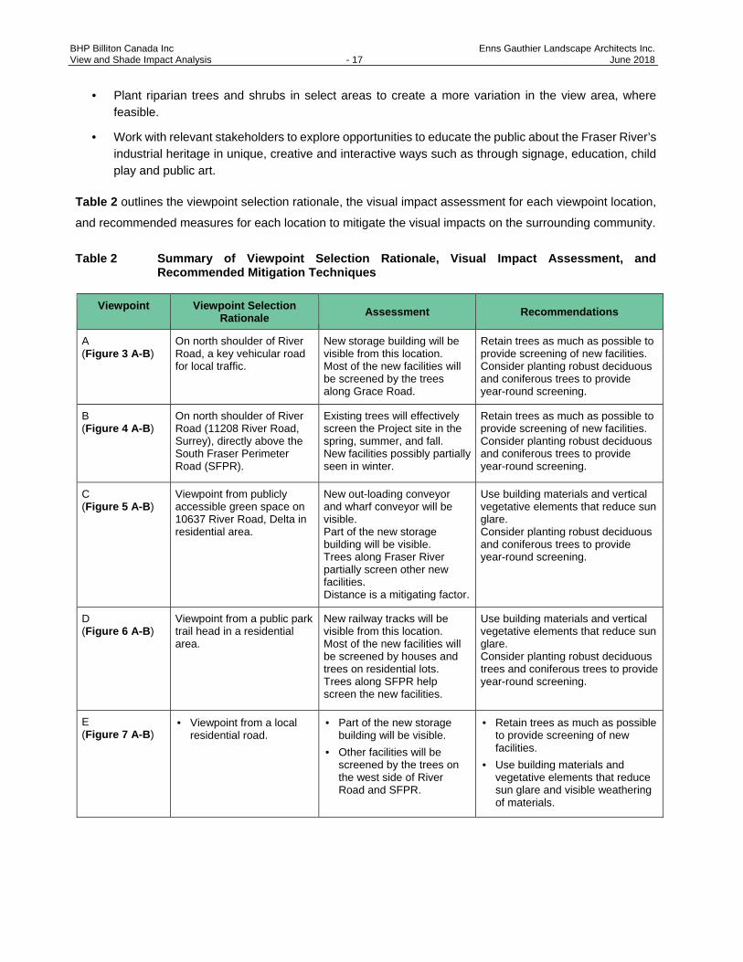
Table 2 Summary of Viewpoint Selection Rationale, Visual Impact Assessment, and
Recommended Mitigation Techniques.............................................................................. 17 List of Figures Figure 1 Aerial View and Location of Viewpoints .............................................................................. 4
Figure 2-A Three-dimensional Model View of the Project Site and Proposed Buildings Looking
Northwest ............................................................................................................................ 6
Figure 2-B Three-dimensional Model View of the Project Site and Proposed Buildings Looking
Southeast ............................................................................................................................ 7
BHP Billiton Canada Inc Enns Gauthier Landscape Architects Inc. View and Shade Impact Analysis - iii June 2018
Figure 3-A Current Westward View from 11665 River Road, Surrey (Viewpoint A) ............................. 8
Figure 3-B Representation of Future Westward View from 11665 River Road, Surrey
(Viewpoint A) ....................................................................................................................... 8
Figure 4-A Current Northwestward View from 11348 River Road, Surrey (Viewpoint B)..................... 9
Figure 4-B Representation of Future Northwestward View from 11348 River Road, Surrey
(Viewpoint B) ....................................................................................................................... 9
Figure 5-A Current Northeastward View from 10637 River Road, Delta (Viewpoint C) ..................... 10
Figure 5-B Representation of Future Northeastward View from 10637 River Road, Delta
(Viewpoint C) ..................................................................................................................... 10
Figure 6-A Current Northwestward View from 11389 Royal Crescent, Surrey (Viewpoint D) ............ 11
Figure 6-B Representation of Future Northwestward View from 11389 Royal Crescent, Surrey
(Viewpoint D) ..................................................................................................................... 11
Figure 7-A Current Westward View from 11483 Millar Road, Surrey (Viewpoint E) .......................... 12
Figure 7-B Representation of Future Westward View from 11483 Millar Road, Surrey
(Viewpoint E) ..................................................................................................................... 12
Figure 8-A Current Southward View from Westminster Quay near River Market (Viewpoint F) ........ 13
Figure 8-B Representation of Future Southward View from Westminster Quay near River
Market (Viewpoint F) ......................................................................................................... 13
Figure 9-A Current Southwestward View from Westminster Pier Park (Viewpoint G) ....................... 14
Figure 9-B Representation of Future Southwestward View from Westminster Pier Park
(Viewpoint G) .................................................................................................................... 14
Figure 10-A Current Southeastward View from Port Royal Park (Viewpoint H) ................................... 15
Figure 10-B Representation of Future Southeastward View from Port Royal Park (Viewpoint H) ....... 15
Figure 11-A Representation of shading effect from Project for March 21 9:00 a.m. Scenario ............. 22
Figure 11-B Representation of shading effect from Project for March 21 12:00 p.m. Scenario ........... 22
Figure 11-C Representation of shading effect from Project for March 21 3:00 p.m. Scenario ............. 23
Figure 12-A Representation of Shading Effect from Project for June 21 9:00 a.m. Scenario .............. 24
Figure 12-B Representation of Shading Effect from Project for June 21 12:00 p.m. Scenario ............ 24
Figure 12-C Representation of Shading Effect from Project for June 21 3:00 p.m. Scenario .............. 25
Figure 13-A Representation of Shading Effect from Project for September 21 9:00 a.m.
Scenario ............................................................................................................................ 26
Figure 13-B Representation of Shading Effect from Project for September 21 12:00 p.m.
Scenario ............................................................................................................................ 26

BHP Billiton Canada Inc Enns Gauthier Landscape Architects Inc. View and Shade Impact Analysis - iv June 2018
Figure 13-C Representation of Shading Effect from Project for September 21 3:00 p.m.
Scenario ............................................................................................................................ 27
Figure 14-A Representation of Shading Effect from Project for December 21 9:00 a.m. Scenario ..... 28
Figure 14-B Representation of Shading Effect from Project for December 21 12:00 p.m.
Scenario ............................................................................................................................ 28
Figure 14-C Representation of Shading Effect from Project for December 21 3:00 p.m. Scenario ..... 29

BHP Billiton Canada Inc Enns Gauthier Landscape Architects Inc. View and Shade Impact Analysis - v June 2018
ACRONYMS, ABBREVIATIONS, SYMBOLS, AND UNITS OF MEASURE
Acronym Definition
BC British Columbia
BHP BHP Billiton Canada Inc.
CAD computer-aided drawing
EG Enns Gauthier Landscape Architects
Project proposed potash export facility
View and Shade Guidelines Project and Environmental Review Guidelines – View and Shade Impact
VFPA Vancouver Fraser Port Authority

BHP Billiton Canada Inc Enns Gauthier Landscape Architects Inc. View and Shade Impact Analysis - 1 June 2018
1. INTRODUCTION
BHP Billiton Canada Inc. (BHP) is proposing to build a potash export facility (Project) at Fraser Surrey Docks
(FSD) in Surrey, British Columbia (BC). The Project site is located on the southeastern shore of the Fraser
River and is oriented northeast to southwest. This land is owned by Vancouver Fraser Port Authority (VFPA)
and currently leased by FSD, which operates a marine cargo terminal. The Project will serve as port site
infrastructure for receiving trains, storing product, and loading ships.
The Project, which requires one permit application, will be equipped with:
· Rail car unloading facility
· Material handling and transfer system
· Product storage building
· Berth improvements and new shiploader
· Railcar unit train loop
· Utility and access improvements (e.g., pedestrian overpass, line painting, etc.).
1.1. OBJECTIVES
In accordance with VFPA’s Project and Environmental Review (PER) Guidelines – View and Shade Impact
(View and Shade Guidelines) (PMV 2015), the Project requires analysis of the effects of the proposed siting,
massing, and height to public and private views of the visual landscape to the surrounding community and
skyline. The View and Shade Guidelines also require study into the potential shade impacts on the surrounding
areas from the Project. Photographs and visual renderings have been provided of existing and proposed
developments according to the Guidelines; potential mitigation strategies for view and shade effects are
discussed in this report.
The Project is zoned Port Terminal in the Land Use Plan (PMV 2014). Consistent with VFPA’s approval
process, a visual impact assessment has been conducted for the Project. The purpose of this assessment is
to:
· Demonstrate that BHP has considered the provisions and requirements of the View and Shade Guidelines (PMV 2015)
· Guide the application of visual mitigation measures
· Support community information sharing and the consultation process.
Enns | Gauthier Landscape Architects (EG) has been tasked with performing the View and Shade study.
Together in collaboration with other environmental and engineering firms, the Project Team will deliver all
necessary reports to PMV for permit approval.
BHP Billiton Canada Inc Enns Gauthier Landscape Architects Inc. View and Shade Impact Analysis - 2 June 2018
2. VIEW STUDY: APPROACH AND METHODOLOGY
This view study and impact assessment focuses on how the Project infrastructure, siting, layout, massing,
materials, and height affect the surrounding community and views from public areas. The following outlines
the approach and methodology used to conduct the assessment.
2.1. BASE INFORMATION, REVIEW, AND COORDINATION
Base information was acquired from Hemmera Envirochem (Hemmera), BHP, vegetation specialists,
surveyors, and civil engineers. This information included:
· Site existing ground contours
· Site aerial photos, at-grade site photos
· Computer-aided drafting (CAD) drawings of existing and proposed facilities
· Rendering perspective of proposed facilities
· Plans for new equipment, structures, and buildings
· Elevation drawings of main facilities
· Sections of structures
· Orthophotos / satellite images in plan view of the site.
Information from these documents was gathered and overlaid to form an assessment of the Project site’s
conditions.
2.2. DESKTOP STUDY
A literature review was conducted of local and regional land use policies, environmental guidelines, VFPA
standards, and BC visual Quality Objective Guidelines. As the site is within VFPA’s jurisdiction and its land
use is designated as Port Terminal, the Project must adhere to the View and Shade Guidelines (PMV 2015).
Design drawings of the new infrastructure provided by BHP were reviewed and assessed. Aerial photos,
satellite images, and at-grade photos were used to conduct an initial study of the immediate and surrounding
areas. City topographic maps were also consulted to furnish a better understanding of elevation changes
surrounding the Project site.
2.3. SITE VISITS AND VIEWPOINT SELECTION
Site reconnaissance is an important part of information gathering and ground truthing to assess the accuracy
of the base information and background studies. Site visits, including inspections of adjacent properties and
the surrounding area, occurred on July 20, 2016 and August 9, 2017. The purpose of the first site visit was to
review existing site conditions and identify potential locations for the view study graphics within the site as well
as additional locations in the neighbouring vicinity. An additional site visit was conducted on August 9, 2017

BHP Billiton Canada Inc Enns Gauthier Landscape Architects Inc. View and Shade Impact Analysis - 3 June 2018
after feedback was gathered from VFPA and BHP, which included a request to obtain information from a
greater variety of viewpoints within the residential community and public vantage points.
Viewpoint selection criteria were established prior to site reconnaissance to help determine possible
viewpoints, as follows:
· High-use public spaces with views to the site
· Viewpoints at elevations with potential view windows over existing trees
· Main roadways near the site with high traffic volumes
· Residential roadways near the site where view quality and neighbourhood character may be affected by the new facilities
· Institutions and community buildings with potential views to the Project site
· Tourist destinations
· Recreational trails and public parks.
As a result of the two site visits and following correspondence with the Project Team, eight locations (A to H,
see Figure 1) were chosen as viewpoints for this study. The viewpoints chosen offered an accurate
representation of the view impacts of the new facility on the surrounding communities:
· South Fraser Perimeter Road
· River Road
· North side of the Fraser River from Queensborough
· Westminster Quay
· Pier Park in New Westminster.
The views from these areas are significant due to their location established in residential neighbourhoods, civic
gathering places, parks, trails, and tourism destinations within the surrounding community. Each viewpoint, its
orientation, description of location, elevation, and distance from the site are summarised in Table 1.
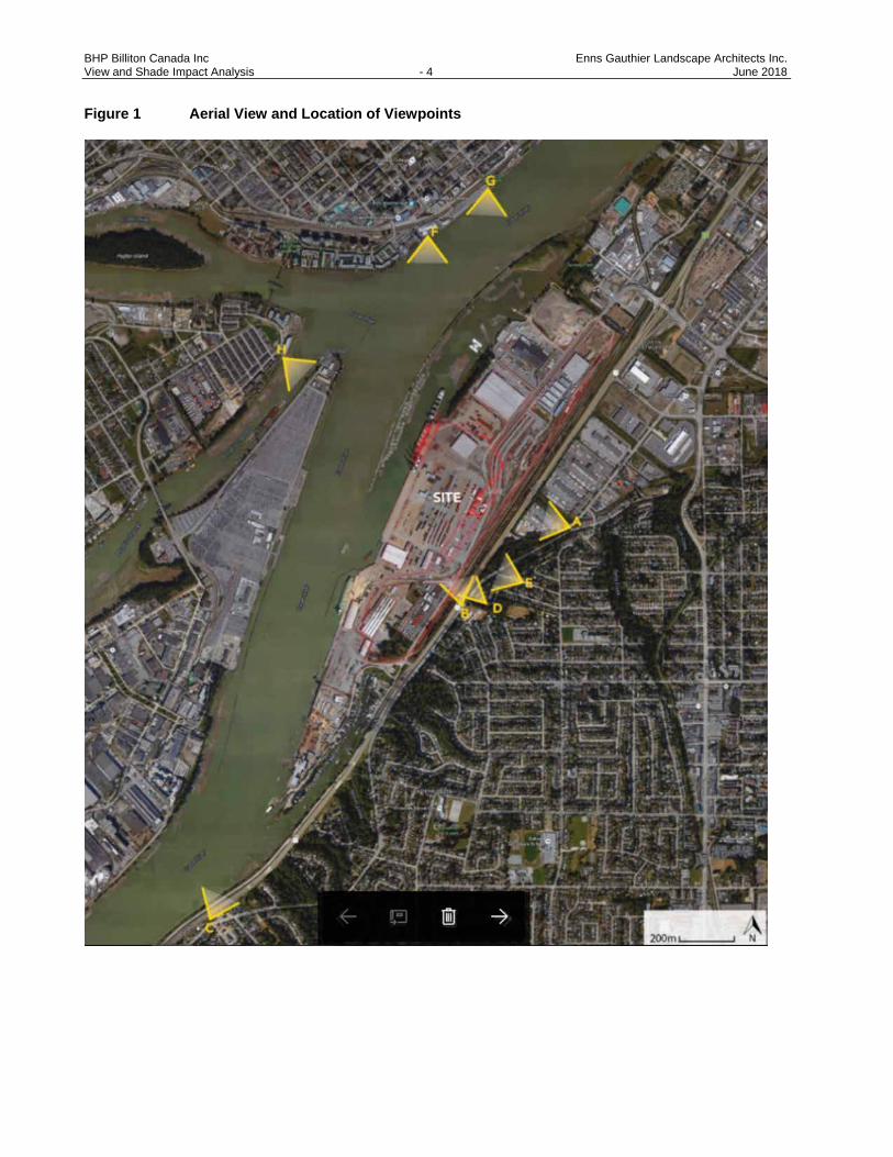
BHP Billiton Canada Inc Enns Gauthier Landscape Architects Inc. View and Shade Impact Analysis - 4 June 2018
Figure 1 Aerial View and Location of Viewpoints
BHP Billiton Canada Inc Enns Gauthier Landscape Architects Inc. View and Shade Impact Analysis - 5 June 2018
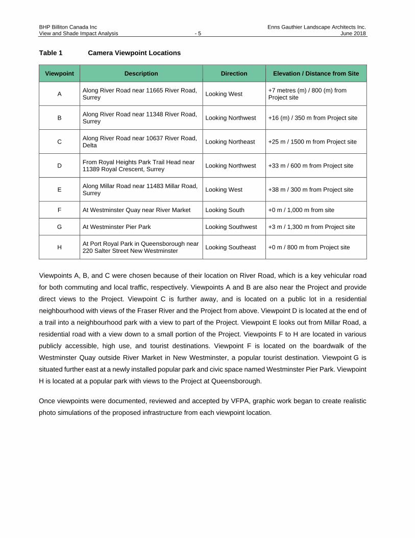
Table 1 Camera Viewpoint Locations
Viewpoint Description Direction Elevation / Distance from Site
A Along River Road near 11665 River Road, Surrey Looking West +7 metres (m) / 800 (m) from
Project site
B Along River Road near 11348 River Road, Surrey Looking Northwest +16 (m) / 350 m from Project site
C Along River Road near 10637 River Road, Delta Looking Northeast +25 m / 1500 m from Project site
D From Royal Heights Park Trail Head near 11389 Royal Crescent, Surrey Looking Northwest +33 m / 600 m from Project site
E Along Millar Road near 11483 Millar Road, Surrey Looking West +38 m / 300 m from Project site
F At Westminster Quay near River Market Looking South +0 m / 1,000 m from site
G At Westminster Pier Park Looking Southwest +3 m / 1,300 m from Project site
H At Port Royal Park in Queensborough near 220 Salter Street New Westminster Looking Southeast +0 m / 800 m from Project site
Viewpoints A, B, and C were chosen because of their location on River Road, which is a key vehicular road
for both commuting and local traffic, respectively. Viewpoints A and B are also near the Project and provide
direct views to the Project. Viewpoint C is further away, and is located on a public lot in a residential
neighbourhood with views of the Fraser River and the Project from above. Viewpoint D is located at the end of
a trail into a neighbourhood park with a view to part of the Project. Viewpoint E looks out from Millar Road, a
residential road with a view down to a small portion of the Project. Viewpoints F to H are located in various
publicly accessible, high use, and tourist destinations. Viewpoint F is located on the boardwalk of the
Westminster Quay outside River Market in New Westminster, a popular tourist destination. Viewpoint G is
situated further east at a newly installed popular park and civic space named Westminster Pier Park. Viewpoint
H is located at a popular park with views to the Project at Queensborough.
Once viewpoints were documented, reviewed and accepted by VFPA, graphic work began to create realistic
photo simulations of the proposed infrastructure from each viewpoint location.

BHP Billiton Canada Inc Enns Gauthier Landscape Architects Inc. View and Shade Impact Analysis - 6 June 2018
2.4. PREPARATION OF PHOTO SIMULATIONS
Renderings of the future view of the Project buildings and structures were prepared for each of the viewpoints
(Figures 3-A through 10-B). The methodology to create the photo simulations is as follows:
1. Use original viewpoint photos for foreground details and existing landscape features (by EG).
2. Use survey data (height contours) of the surrounding landscape (City of Surrey).
3. Use technical drawings of the proposed site plans and building dimensions (provided by BHP, 2017).
4. Confirm CAD base plans of the proposed facility (provided by BHP).
5. Overlay the base plans with computer-generated three-dimensional (3D) models of the proposed infrastructure (provided by BHP; see Figure 2-A and 2-B).
6. Generate snapshots with 3D model corresponding with approved viewpoints.
7. Import 3D snapshot frames to photo manipulation software (Photoshop), and produce realistically rendered buildings, structures, and surfaces and vegetation.
Figure 2-A Three-dimensional Model View of the Project Site and Proposed Buildings Looking Northwest

BHP Billiton Canada Inc Enns Gauthier Landscape Architects Inc. View and Shade Impact Analysis - 7 June 2018
Figure 2-B Three-dimensional Model View of the Project Site and Proposed Buildings Looking Southeast
3. VISUAL IMPACT PHOTO SIMULATIONS
After the computer-generated model snapshots were superimposed on the current viewpoints they were further
manipulated to remove site features that will no longer be present and to add proposed infrastructure. In the
following section, a photograph of existing conditions from the selected viewpoint is shown beside a computer-
rendered image to illustrate Project-related potential effects from that vantage point. Existing and rendered
graphics are shown in the subsequent Figure 3-A through 10-B along with a description of the viewpoint,
rationale for site selection, and preliminary assessment of visual impacts.
BHP Billiton Canada Inc Enns Gauthier Landscape Architects Inc. View and Shade Impact Analysis - 8 June 2018
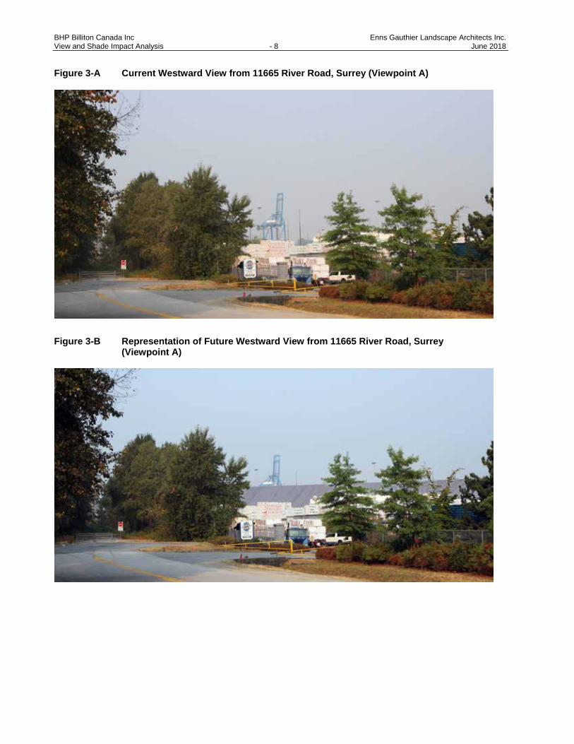
Figure 3-A Current Westward View from 11665 River Road, Surrey (Viewpoint A)
Figure 3-B Representation of Future Westward View from 11665 River Road, Surrey (Viewpoint A)

BHP Billiton Canada Inc Enns Gauthier Landscape Architects Inc. View and Shade Impact Analysis - 9 June 2018
Figure 4-A Current Northwestward View from 11348 River Road, Surrey (Viewpoint B)
Figure 4-B Representation of Future Northwestward View from 11348 River Road, Surrey (Viewpoint B)

BHP Billiton Canada Inc Enns Gauthier Landscape Architects Inc. View and Shade Impact Analysis - 10 June 2018
Figure 5-A Current Northeastward View from 10637 River Road, Delta (Viewpoint C)
Figure 5-B Representation of Future Northeastward View from 10637 River Road, Delta
(Viewpoint C)

BHP Billiton Canada Inc Enns Gauthier Landscape Architects Inc. View and Shade Impact Analysis - 11 June 2018
Figure 6-A Current Northwestward View from 11389 Royal Crescent, Surrey (Viewpoint D)
Figure 6-B Representation of Future Northwestward View from 11389 Royal Crescent, Surrey (Viewpoint D)
BHP Billiton Canada Inc Enns Gauthier Landscape Architects Inc. View and Shade Impact Analysis - 12 June 2018
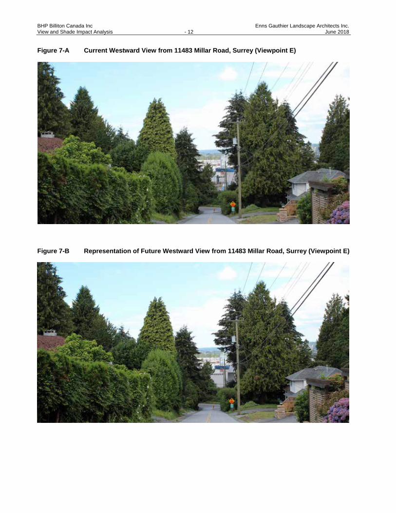
Figure 7-A Current Westward View from 11483 Millar Road, Surrey (Viewpoint E)
Figure 7-B Representation of Future Westward View from 11483 Millar Road, Surrey (Viewpoint E)

BHP Billiton Canada Inc Enns Gauthier Landscape Architects Inc. View and Shade Impact Analysis - 13 June 2018
Figure 8-A Current Southward View from Westminster Quay near River Market (Viewpoint F)
Figure 8-B Representation of Future Southward View from Westminster Quay near River Market (Viewpoint F)

BHP Billiton Canada Inc Enns Gauthier Landscape Architects Inc. View and Shade Impact Analysis - 14 June 2018
Figure 9-A Current Southwestward View from Westminster Pier Park (Viewpoint G)
Figure 9-B Representation of Future Southwestward View from Westminster Pier Park
(Viewpoint G)
BHP Billiton Canada Inc Enns Gauthier Landscape Architects Inc. View and Shade Impact Analysis - 15 June 2018
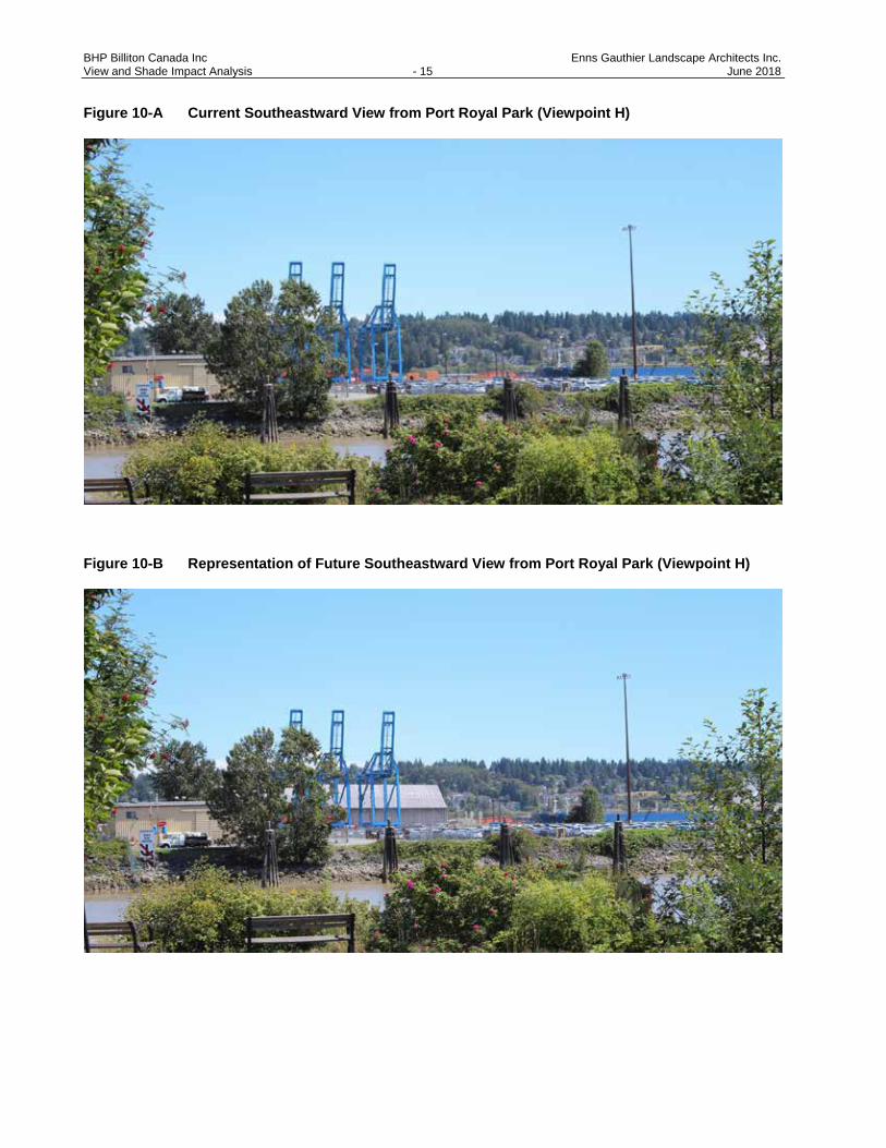
Figure 10-A Current Southeastward View from Port Royal Park (Viewpoint H)
Figure 10-B Representation of Future Southeastward View from Port Royal Park (Viewpoint H)

BHP Billiton Canada Inc Enns Gauthier Landscape Architects Inc. View and Shade Impact Analysis - 16 June 2018
4. VIEW STUDY IMPACT ASSESSMENT AND RECOMMENDATIONS
The Project lies in land managed by VFPA and thus must adhere to View and Shade Guidelines (PMV 2015).
The lands border the City of Surrey, near populated neighbourhoods and major thoroughfares, and must take
into account the potential view impacts on these areas. The site is also located on the Fraser River, across
from the industrial and residential areas of Queensborough. As such, a review of the photo simulations and
subsequent visual impact assessment of the proposed facilities on the selected viewpoints form the basis of
EG’s recommendations for mitigation techniques where appropriate.
In general, the potential view effects of the Project on the surrounding communities, roadways, park lands, and
public spaces with views to the site are minimal, as per the following summary assessment:
· Much of the Project site is surrounded by tall, dense vegetation to the east and southeast. These trees will shield most of the new infrastructure from the residential slopes south of the site as well as the main roadways south of the site.
· There is an abundance of tall, mature deciduous and coniferous trees throughout the residential areas, parks, and neighbourhood roadways on the slopes south of the Project site, minimising any significant views of the Project site;
· Distance across the Fraser River is a mitigating factor to reduce visual impact. The Project is located sufficiently far away from public viewpoints of the surrounding communities, residential areas, pathways, tourist destinations, and public parks in New Westminster. In addition, mature trees along River Road will also minimise the impacts to views caused by proposed Project structures.
· Select views from across the Fraser River from residential areas and public parks in Queensborough may be affected by construction of the proposed facilities in specific locations; however, existing industrial land uses within these view corridors means the Project causes minimal impact to the skyline as a whole. The proposed structures are also obscured by Annacis Island and ship activity in the Fraser River.
· The Project site is within an industrial zoned land use area, thus minimizing potential effects on the local skyline as the new facilities will effectively blend in with adjacent industries and infrastructure.
For viewpoints that would result in an adverse impact as a result of the construction of the proposed facilities,
the following mitigation measures are recommended for consideration on a site-by-site basis:
· Retain trees as much as possible within the Project site to provide screening of new facilities.
· Install fast-growing and robust deciduous trees (which will screen the facilities relatively quickly) and conifers to provide year-round screening in areas that do not conflict with facility operations.
· Use building materials and vegetative elements that reduce sun glare and visible weathering of materials. For example, consider installing:
▫ Vertical architectural screens or elements against the infrastructure to improve aesthetics.
▫ Vertical green screens against building facades and expansive walls, which will encourage vertical plant growth
BHP Billiton Canada Inc Enns Gauthier Landscape Architects Inc. View and Shade Impact Analysis - 17 June 2018
· Plant riparian trees and shrubs in select areas to create a more variation in the view area, where feasible.
· Work with relevant stakeholders to explore opportunities to educate the public about the Fraser River’s industrial heritage in unique, creative and interactive ways such as through signage, education, child play and public art.
Table 2 outlines the viewpoint selection rationale, the visual impact assessment for each viewpoint location,
and recommended measures for each location to mitigate the visual impacts on the surrounding community.
Table 2 Summary of Viewpoint Selection Rationale, Visual Impact Assessment, and Recommended Mitigation Techniques
Viewpoint Viewpoint Selection Rationale Assessment Recommendations
A (Figure 3 A-B)
On north shoulder of River Road, a key vehicular road for local traffic.
New storage building will be visible from this location. Most of the new facilities will be screened by the trees along Grace Road.
Retain trees as much as possible to provide screening of new facilities. Consider planting robust deciduous and coniferous trees to provide year-round screening.
B (Figure 4 A-B)
On north shoulder of River Road (11208 River Road, Surrey), directly above the South Fraser Perimeter Road (SFPR).
Existing trees will effectively screen the Project site in the spring, summer, and fall. New facilities possibly partially seen in winter.
Retain trees as much as possible to provide screening of new facilities. Consider planting robust deciduous and coniferous trees to provide year-round screening.
C (Figure 5 A-B)
Viewpoint from publicly accessible green space on 10637 River Road, Delta in residential area.
New out-loading conveyor and wharf conveyor will be visible. Part of the new storage building will be visible. Trees along Fraser River partially screen other new facilities. Distance is a mitigating factor.
Use building materials and vertical vegetative elements that reduce sun glare. Consider planting robust deciduous and coniferous trees to provide year-round screening.
D (Figure 6 A-B)
Viewpoint from a public park trail head in a residential area.
New railway tracks will be visible from this location. Most of the new facilities will be screened by houses and trees on residential lots. Trees along SFPR help screen the new facilities.
Use building materials and vertical vegetative elements that reduce sun glare. Consider planting robust deciduous trees and coniferous trees to provide year-round screening.
E (Figure 7 A-B)
· Viewpoint from a local residential road.
· Part of the new storage building will be visible.
· Other facilities will be screened by the trees on the west side of River Road and SFPR.
· Retain trees as much as possible to provide screening of new facilities.
· Use building materials and vegetative elements that reduce sun glare and visible weathering of materials.

BHP Billiton Canada Inc Enns Gauthier Landscape Architects Inc. View and Shade Impact Analysis - 18 June 2018
Viewpoint Viewpoint Selection Rationale Assessment Recommendations
F (Figure 8 A-B)
· Near Westminster Quay, a popular public place and tourist destination New Westminster.
· Most of the new facilities will be visible from this location.
· Loading ships, other nearby industrial facilities, and riparian vegetation partially block view of new facilities.
· Distance is a mitigating factor.
· Use building materials and vertical vegetative elements that reduce sun glare.
· Plant riparian trees and shrubs in select areas to create a more variation in the view area, where feasible.
· Explore opportunities to educate the public about the Fraser River’s industrial heritage in unique, creative and interactive ways.
G (Figure 9 A-B)
· On riverfront walkway in Westminster Pier Park, a public place and tourist destination in New Westminster.
· New storage building and new substation will be visible from this location.
· Loading ships, other nearby industrial facilities, and riparian vegetation partially block view of new facilities.
· Distance is a mitigating factor.
· Use building materials and vertical vegetative elements that reduce sun glare.
· Plant riparian trees and shrubs in select areas to create a more variation in the view area, where feasible.
· Explore opportunities to educate the public about the Fraser River’s industrial heritage in unique, creative and interactive ways.
H (Figure 10 A-B)
· On Port Royal Park, a popular park and civic space.
· Queensborough industrial parks partially blocks view of new facilities, however, new storage building and new substation will be visible;
· Existing facilities already currently visible;
· Nearby existing industrial activity are mitigating factors.
· Use building materials and vertical vegetative elements that reduce sun glare.
· Plant riparian trees and shrubs in select areas to create a more variation in the view area, where feasible.
· Explore opportunities to educate the public about the Fraser River’s industrial heritage in unique, creative and interactive ways.

BHP Billiton Canada Inc Enns Gauthier Landscape Architects Inc. View and Shade Impact Analysis - 19 June 2018
5. SHADE STUDY: APPROACH AND METHODOLOGY
The Shade Study report will focus on how shade generated by the Project siting, layout, massing, and height
may have impacts on the surrounding community and public areas at different times of the day and year. The
following outlines our approach and methodology.
5.1. BASE INFORMATION, REVIEW AND COORDINATION
Base information was acquired from Hemmera, BHP surveyors, civil engineers, and a 3D graphic specialist.
Information from these documents was gathered and overlaid to form an informative picture of the site’s
conditions and adjacent land uses, infrastructure, and potential public areas, which could experience increased
shade. This information included:
· Site existing ground contours
· Site aerial photos, at-grade site photos showing current adjacent land use and zoning
· CAD drawings of existing and proposed facilities
· Rendering perspective of proposed facilities
· Plans for new equipment, structures, and buildings
· Elevation drawings of Main Plant area
· Sections of proposed structures, orthophotos / satellite images in plan view of the site.
It was noted during this process that all adjacent buildings to the Project site are zoned industrial, limiting any
shade effects on public spaces, roads, residential lots, or parks. Similarly, the adjacent industrial buildings are
a sufficient distance away from the proposed infrastructure, resulting in an expected low shade impact and
minimal (if any) reduction in direct sunlight received at these adjacent buildings.
5.2. DESKTOP STUDY
A literature review of local and regional land use policies, environmental guidelines, VFPA standards, and BC
Visual Quality Objective Guidelines was conducted, including a review of as-built drawings of the proposed
infrastructure provided by BHP. Aerial photos, orthophotos, and Google Maps were used to study the
immediate and surrounding areas, buildings, uses, and vegetation that may be affected by the proposed
infrastructure.
5.3. SITE RECONNAISSANCE
Visits of the site, adjacent properties, and the surrounding area informed the review of existing conditions, and
helped to confirm and identify adjacent land uses and properties; potential locations for public gatherings;
community gardens; playgrounds; or other uses that may be negatively affected by shade. Site reconnaissance
is an important part of information gathering and ground truthing to assess the accuracy of the base information
and desktop studies. Visits to the Project site, adjacent properties, and the surrounding area occurred on

BHP Billiton Canada Inc Enns Gauthier Landscape Architects Inc. View and Shade Impact Analysis - 20 June 2018
July 20, 2016 and August 9, 2017. The purpose of these visits was to review existing site conditions, confirm
adjacent land uses, and identify potential buildings or infrastructure close enough to the Project site that may
be affected by increased shade. Existing vegetation adjacent to the Project site was also inspected (from the
Project Site) for potential reduced direct sunlight due to shade from the new facilities.
It was confirmed during both site visits that the surrounding land use is exclusively industrial, with no public
roads, parks, paths, community assets, public gathering spaces, or residential areas close enough to be
affected. The site visit also confirmed that, due to existing industrial development surrounding the site, there
were no concerns of affected vegetation (through loss of direct sunlight) in areas adjacent to the Project site
due to the proposed facilities.
5.4. PREPARATION OF SHADE STUDY GRAPHICS: 3D SHADOW MODELLING
A 3D model provided by BHP was imported into CAD drawings (Vectorworks). Shadow settings were then
applied to the model on the dates identified in the View and Shade Guidelines (PMV 2015); specifically, at
9:00 a.m., 12:00 p.m., and 3:00 p.m. during the following periods:
· Spring Equinox (March 21)
· Summer Solstice (June 21)
· Fall Equinox (September 21)
· Winter Solstice (December 21).
The shade study graphics were completed through the following process:
1. 3D design model exported from AutoCAD into CAD-based software (Vectorworks).
2. Model simplified to remove unnecessary elements (i.e., interior and underground features).
3. Initial base image of the model exported without shadows.
4. Shadow settings applied on the location of the Project site according to the requested dates and times in the View and Shade Guidelines (VFPA 2015).
5. Model and various shadow settings overlain onto the base orthophoto, to scale.
6. For clarity, enhanced contrast applied to shadows and proposed infrastructure using Photoshop.

BHP Billiton Canada Inc Enns Gauthier Landscape Architects Inc. View and Shade Impact Analysis - 21 June 2018
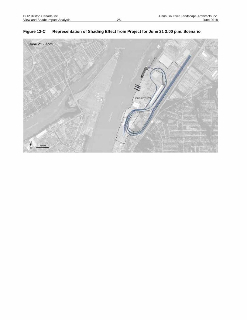
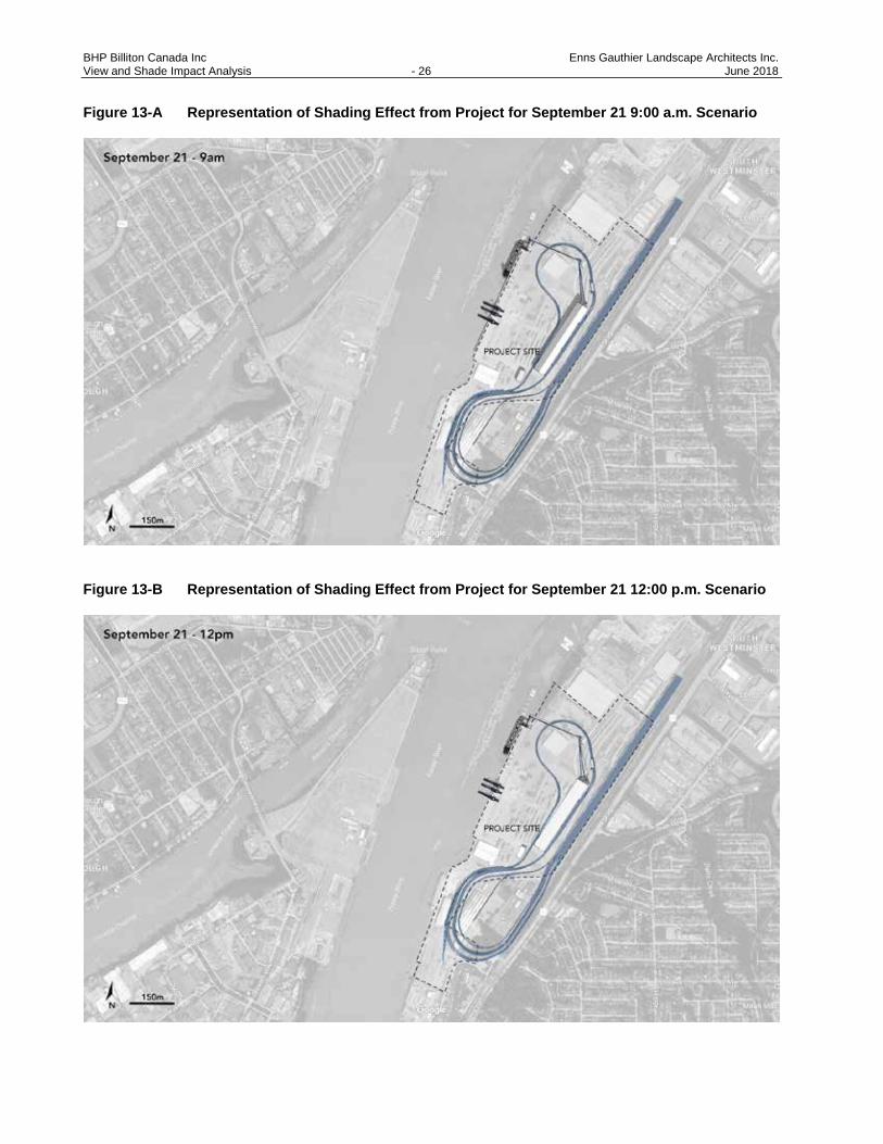
6. SHADE IMPACT STUDY - 3D SHADOW MODELLING
The study covers the range of sun’s movements during the year. Shade impact renderings indicate where
shadows would cast footprints from the Project infrastructure during the same four periods of the year identified
in Section 5.4, and shown in Figures 11 through 14. During solstice, the sun reaches its highest or lowest
point in the sky; during equinox, the sun is aligned with the equator. The height of the sun is the same during
the spring and fall equinox, and different shadows are created due to the sun’s position relative to the equator.
Shade studies were also created to show how shadows are created as the sun rises and sets throughout the
day at 9:00 a.m., 12:00 p.m., and 3:00 p.m. to show the resulting shadow that would be cast from the structures
onto the Project site and surrounding area. These are shown as Figure A, B, and C respectively for each time
period of the year.
See Figures 11 through 14 for accurate representations of the shadows cast by the proposed facilities onto
the Project site and surrounding areas.

BHP Billiton Canada Inc Enns Gauthier Landscape Architects Inc. View and Shade Impact Analysis - 22 June 2018
Figure 11-A Representation of shading effect from Project for March 21 9:00 a.m. Scenario
Figure 11-B Representation of shading effect from Project for March 21 12:00 p.m. Scenario

BHP Billiton Canada Inc Enns Gauthier Landscape Architects Inc. View and Shade Impact Analysis - 23 June 2018
Figure 11-C Representation of shading effect from Project for March 21 3:00 p.m. Scenario
BHP Billiton Canada Inc Enns Gauthier Landscape Architects Inc. View and Shade Impact Analysis - 24 June 2018
Figure 12-A Representation of Shading Effect from Project for June 21 9:00 a.m. Scenario
Figure 12-B Representation of Shading Effect from Project for June 21 12:00 p.m. Scenario
BHP Billiton Canada Inc Enns Gauthier Landscape Architects Inc. View and Shade Impact Analysis - 25 June 2018
Figure 12-C Representation of Shading Effect from Project for June 21 3:00 p.m. Scenario
BHP Billiton Canada Inc Enns Gauthier Landscape Architects Inc. View and Shade Impact Analysis - 26 June 2018
Figure 13-A Representation of Shading Effect from Project for September 21 9:00 a.m. Scenario
Figure 13-B Representation of Shading Effect from Project for September 21 12:00 p.m. Scenario

BHP Billiton Canada Inc Enns Gauthier Landscape Architects Inc. View and Shade Impact Analysis - 27 June 2018
Figure 13-C Representation of Shading Effect from Project for September 21 3:00 p.m. Scenario

BHP Billiton Canada Inc Enns Gauthier Landscape Architects Inc. View and Shade Impact Analysis - 28 June 2018
Figure 14-A Representation of Shading Effect from Project for December 21 9:00 a.m. Scenario
Figure 14-B Representation of Shading Effect from Project for December 21 12:00 p.m. Scenario

BHP Billiton Canada Inc Enns Gauthier Landscape Architects Inc. View and Shade Impact Analysis - 29 June 2018
Figure 14-C Representation of Shading Effect from Project for December 21 3:00 p.m. Scenario

BHP Billiton Canada Inc Enns Gauthier Landscape Architects Inc. View and Shade Impact Analysis - 30 - June 2018
7. SHADE STUDY IMPACT ASSESSMENT AND RECOMMENDATIONS
In summary, the shade impact renderings and 3D shadow models indicate that the Project is sufficiently far
from the surrounding residential communities and the road such that there will likely be little to no impact
from shadows on the public. The renderings also show that the adjacent industrial site to the northeast and
to the southwest are generally unaffected by shade throughout the year; however, the adjacent site to the
northeast and the rail track to the east will likely be somewhat affected by the shade caused by the new
railcar unloading station and new storage building around the time of the winter solstice (December 21),
particularly during the late afternoon and evening as the sun migrates to the west, as seen in Figure 14-C.
Given existing industrial development in this area, these effects are considered minimal, and do not require
mitigation against potential shade impacts.

BHP Billiton Canada Inc Enns Gauthier Landscape Architects Inc. View and Shade Impact Analysis - 31 - June 2018
8. CONCLUSION
Based on the graphic renderings and simulations contained herein, the Project adheres to the View and
Shade Guidelines (PMV 2015). Project is consistent with existing land uses, and will increase efficiencies
and productivity of PMV industrial land.
In general, the Project will likely have a minimal impact on views in surrounding communities. To the south
of the Project site, existing mature tree stands form a natural vegetative screen to the proposed facilities.
To the east, the views are more open to the Project site; however, the existing industrial use and
infrastructure predominates in this area, and is similar to the proposed infrastructure in terms of skyline,
massing and building materials. As such, the views to the Project site would not be adversely affected. The
most affected views to the site will likely be from the north, along the New Westminster and Queensborough
waterfront areas facing south and southeast. Recommendations on techniques to mitigate adverse visual
effects have been discussed in this report for key public, tourist, and residential locations in this area. In
certain areas where these mitigation techniques are not applicable or desired, an alternative approach
would be to celebrate the rich industrial heritage of the Fraser River through education, child play,
interpretive signage and public art.
Likewise, the shade impact on the site and surrounding areas would be minimal, given the current industrial
land use zone surrounding the site, as well as the large distances from the site to any public place, roadway,
pathway, gathering space, or residence. Materials proposed for use on the Project and the sizes of the
proposed conveyors, storage structures, and rail ramps are consistent with prior use at the site and
surrounding industrial and port activity, and are not viewed as an adverse Project-related effect.
Study findings produced and analyzed in this report will be submitted to VFPA for approval. Subsequently,
a public consultation component may follow in which information from this report is shared with the public.
In addition, input may be sought by concerned members of the public regarding further mitigation strategies
and techniques.

BHP Billiton Canada Inc Enns Gauthier Landscape Architects Inc. View and Shade Impact Analysis - 32 - June 2018
9. CLOSING
This report has been prepared by Enns Gauthier Landscape Architects (EG), based on fieldwork conducted
and renderings produced by EG, for the sole benefit and exclusive use of BHP Billiton Canada Inc. (BHP)
and Hemmera Envirochem Inc. (Hemmera). The material in it reflects EG’s best judgement in light of the
information available to it at the time of preparing this Report. Any use that a third party makes of this report,
or any reliance on or decision made based on it, is the responsibility of such third parties. EG accepts no
responsibility for damages, if any, suffered by any third party as a result of decisions made or actions taken
based on this report.
EG has performed the work as described above and made the findings and conclusions set out in this
report in a manner consistent with the level of care and skill normally exercised by members of the
landscape architecture and planning profession practicing under similar conditions at the time the work was
performed.
This report represents a reasonable review of the information available to EG within the established scope,
work schedule, and budgetary constraints. The conclusions and recommendations contained in this report
are based upon applicable legislation existing at the time the Report was drafted. Any changes in the
legislation may alter the conclusions and/or recommendations contained in the report. Regulatory
implications discussed in this report were based on the applicable legislation existing at the time this report
was written.
In preparing this report, EG has relied in good faith on information provided by others as noted in this report,
and has assumed that the information provided by those individuals is both factual and accurate. EG
accepts no responsibility for any deficiency, misstatement or inaccuracy in this report resulting from the
information provide by those individuals.
The liability of EG to BHP and Hemmera shall be limited to injury or loss caused by the negligent acts of
EG. The total aggregate liability of EG related to this agreement shall not exceed the lesser of the actual
damages incurred, or the total fee of EG for services rendered for this Project.
Report prepared by: Enns | Gauthier Landscape Architects Inc. Mike Enns, BCSLA, CSLA Principal Elaine Zeng, MLA Intern Landscape Architect

BHP Billiton Canada Inc Enns Gauthier Landscape Architects Inc. View and Shade Impact Analysis - 33 - June 2018
10. REFERENCES
Port Metro Vancouver (PMV). 2015. Project and Environmental Review (PER) Guidelines - View and Shade
Impact. July 2015. Available at https://www.portvancouver.com/wp-content/uploads/2015/05/PER-
View-and-Shade-Impact-Guidelines-FINAL-2015-07-13.pdf. Accessed August 2017.
Port Metro Vancouver (PMV). 2014. Land Use Plan. Adopted October 28, 2014. Available at
https://www.portvancouver.com/wp-content/uploads/2015/06/port-metro-vancouver-land-use-
plan-english.pdf. Accessed August 2017.