victorian civil and administrative tribunal - vcat
TRANSCRIPT

VICTORIAN CIVIL AND ADMINISTRATIVE TRIBUNAL
PLANNING AND ENVIRONMENT DIVISION
PLANNING AND ENVIRONMENT LIST
VCAT REFERENCE NO. P2390/2018
PERMIT APPLICATION NO. PP2018/060
CATCHWORDS
Section 77 of the Planning and Environment Act 1987; Corangamite Planning Scheme; Renewable
Energy Facility; Solar Farm; Farming Zone; Visual Impact; Landscape Significance; Agricultural
Land; Productive Land; Bushfire Management; Flooding and Drainage; Net Community Benefit.
APPLICANT Bookaar Renewables Pty Ltd
RESPONSIBLE AUTHORITY Corangamite Shire Council
REFERRAL AUTHORITIES Department of Environment, Land, Water and
Planning; Country Fire Authority; VicRoads
RESPONDENTS Ian William Urquhart; Andrew Duynhoven;
Charles Raymond Howley; Andrew and Sophie
Wilson; Gillian Ruth Howley; Egon Walter
Marburg; Catherine Beth Marburg; Marie
Thornton; Robert Towner; Rodney Johnson and
others; Andrew Smith; Geoff Smith; Joan
Elizabeth Mahony; Laurie Hickey; Wendy
Dianne Ward; Fiona Dean
SUBJECT LAND 520 Meningoort Road, Lots 51 and 52 and Res
1 on LP4677 and adjacent parts of Meningoort
Road, Bookaar
WHERE HELD Warrnambool (Days 1 – 3), Bookaar and
Camperdown (Day 4 site inspection) and
Melbourne (Days 5 – 10)
BEFORE Mark Dwyer, Deputy President
Margaret Baird, Senior Member
HEARING TYPE Hearing
DATES OF HEARING 17, 18, 19, 20, 24, 25, 26 & 27 June; and
1 & 2 July 2019
DATE OF ORDER 15 August 2019
CITATION Bookaar Renewables Pty Ltd v Corangamite SC
[2019] VCAT 1244

VCAT Reference No. P2390/2018 Page 2 of 79
ORDER Permit application amended
1 Pursuant to clause 64 of schedule 1 of the Victorian Civil and Administrative
Tribunal Act 1998, the permit application is amended by:
• Substituting for the application plans the following set of six sheets of
plans appended to correspondence from Best Hooper to the Victorian
Civil and Administrative dated 14 May 2019:
o Plan prepared by Eco Logical Australia dated 09/05/2019;
o Appendix 1; Diagram 1 (undated);
o Appendix 1: Diagram 2 prepared by Eco Logical Australia dated
06/05/2019;
o Appendix 1: Diagram 3 prepared by Eco Logical Australia dated
09/05/2019;
o Appendix 1: Diagram 4 prepared by Eco Logical Australia dated
06/05/2019; and
o Appendix 1 - Diagram 5 (undated).
• Describing the subject land as:
520 Meningoort Road, Lots 51 and 52 and Res 1 on LP4677 and adjacent parts
of Meningoort Road, Bookaar (including the following lots – Lots 1, 2, 3, 4, 5,
6, 7, 8, 9 (part), 10 (part), 11 (part), 12 (part), 13 (part) on Title Plan 844741K,
Lots 51 , 52 and Res 1 on LP4677 and Meningoort Road (part).
Decision
2 In proceeding P2390/2018, the decision of the responsible authority is
affirmed.
3 In planning permit application PP2018/060 (as amended), no permit is issued.
Mark Dwyer
Deputy President
Margaret Baird
Senior Member

VCAT Reference No. P2390/2018 Page 3 of 79
APPEARANCES
For applicant Mr J Cicero, solicitor, Best Hooper. He called expert evidence
from the following persons:
• Mr J Glossop, town planner.
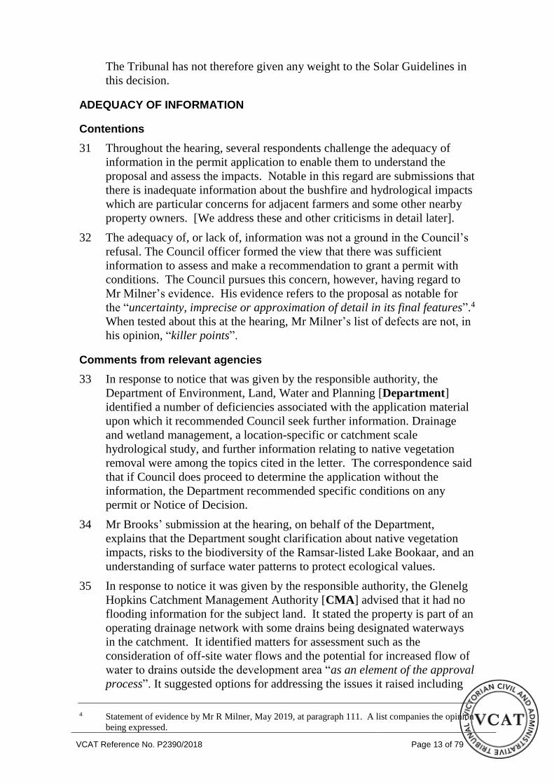
• Dr M Jempson, civil engineer (hydrology).
• Mr D Poole, agricultural consultant.
• Mr H Burge, landscape architect & visual impact
consultant.
• Mr V Gnanakone, traffic engineer.
• Mr L Kern, ecological and bushfire consultant.
• Mr D Scrivener, environmental scientist (glint and glare).
• Mr J Noronha, economist.
For responsible
authority Mr D Vorchheimer, solicitor, HWL Ebsworth. He called expert
evidence from the following persons:
• Mr R Milner, town planner.
• Mr C Goss, author of photomontages
For referral
authorities Mr S Foster, Land Use Planning Program Leader, and Mr M
Allen, State Infrastructure and Dangerous Goods Team Leader,
Country Fire Authority.
Mr G Brooks, Program Manager Planning Approvals Barwon
South West Region, Department of Environment, Land, Water
and Planning.
For respondents Mr A Duynhoven in person. He called expert evidence (also on
behalf of A Wilson and A Smith) from the following person:
• Mr S Kenny, agricultural consultant.
Mr R Johnson for Rodney Johnson and others.
Mr A Wilson, Mrs S Wilson, Mr R Howley, Mrs G Howley,
Ms M Thornton, Mr R Towner, Ms J Mahony, Ms B Marburg,
Mr A Smith, Mr I Urquhart, Ms R Brain, Ms W Ward, Ms F
Dean, Mr L Hickey and Mr G Smith all in person.

VCAT Reference No. P2390/2018 Page 4 of 79
INFORMATION
Description of
proposal
Use and develop the subject land for a renewable energy
facility; a 200MW solar power installation. It would consist
of up to 700,000 photovoltaic (PV) solar panels and
infrastructure and works, such as drainage, inverters, a
substation, an office, water tanks and parking area. The PV
panels have a surface area of 2 metres x 1 metre with a height
of 4 metres. Based on the applicant’s modified position
during the hearing, the panels would be mounted on a single
axis tracking system. The panels rotate on a north-south axis
following the sun from east to west on an arc with a
maximum tilt of 600 below horizontal. A 30-year project life
is intended. Some vegetation removal is proposed to
construct two culverts. Boundary planting is proposed to
supplement existing vegetation.
Nature of
proceeding
Application under section 77 of the Planning and
Environment Act 1987 to review a refusal to grant a permit.
Planning scheme Corangamite Planning Scheme [scheme].
Zone and overlays Farming Zone. The subject land is not within a Significant
Landscape Overlay (SLO1) and Heritage Overlay (HO80)
that affect parts of ‘Meningoort’. The homestead is included
on the Victorian Heritage Register (VHR Number HO300).
Permit requirements Clause 35.07 to use and develop the land for a renewable
energy facility. Clause 52.17 to remove native vegetation.
Key scheme
policies and
provisions
Clauses 11, 12, 13, 14, 15, 17, 19, 21, 35.07, 52.06, 52.17,
53.13, 65 and 71.
Subject land
description
The subject land is part of ‘Meningoort’, north-west of
Camperdown. The entire holding is some 2,024ha and used
for agriculture (primarily cropping, beef and sheep
production). The elongated-shaped site [subject land] for
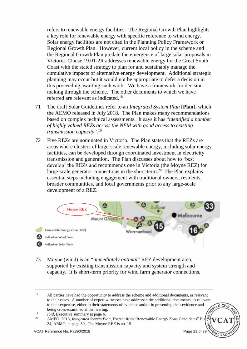
the proposed solar energy facility is 588ha. It comprises all
or part of 16 land parcels and parts of Meningoort Road
where licenses operate. A 220kV transmission line traverses
the subject land. The subject land is east of the homestead
that is on the lower south-east side of Mount Meningoort.
Some 98ha of the subject land is leased by a local farmer for
cropping.
Tribunal inspection Accompanied by the parties on Day 4 of the hearing
including inspecting the subject land, some nearby and
surrounding properties, public roads, and longer range
viewing points such as from Mt Leura and the Camperdown
Botanic Gardens.

VCAT Reference No. P2390/2018 Page 5 of 79
Tribunal cases
referred to
ESCO Pacific Pty Ltd v Wangaratta RCC [2019] VCAT 219.
Croke v Moira SC [2019] VCAT 112.

VCAT Reference No. P2390/2018 Page 6 of 79
REASONS1
OVERVIEW AND EXECUTIVE SUMMARY
1 Bookaar Renewables Pty Ltd proposes a large solar energy facility on part
of the Meningoort property at Bookaar, near Camperdown. The facility
would comprise up to 700,000 solar panels, with an installed generation
capacity up to 200MW, on a site of 588ha. The electricity generated by the
solar panels would connect to the existing 220-kV transmission line that
traverses the land.
2 The Corangamite Shire Council refused the permit application on six
grounds, and a number of local objectors have raised additional concerns
about the proposal. The applicant has sought to review the Council refusal
at VCAT.
3 In undertaking the review, the Tribunal must consider whether the proposal
produces an acceptable planning outcome having regard to the relevant
planning controls, policies, application requirements, and decision
guidelines in the scheme. In doing so, as a matter of integrated decision-
making, the Tribunal must endeavour to integrate the range of planning
policies relevant to the issues to be determined and balance conflicting
objectives in favour of net community benefit and sustainable development
for the benefit of present and future generations.
4 Amongst the many issues raised by the parties, the Tribunal has identified
six issues that it considers to be determinative to the decision whether to
grant a planning permit for the solar energy facility at Bookaar. These are:
• Planning policy support for renewable energy facilities.
• The loss of productive agricultural land.
• Significant landscape values and/or visual impact.
• Hydrological issues such as drainage, runoff and flooding.
• Bushfire management.
• The adequacy of the information and plans in support of the
application, including site layout plans.
5 In relation to the first three of these issues, the Tribunal’s preliminary
assessment is that the balancing of conflicting objectives would be unlikely
to lead to the refusal of a permit for the solar energy facility at Bookaar. In
particular:
• At a State level, there is strong planning policy support for renewable
energy facilities, in appropriate locations and subject to site suitability.
1 The submissions and evidence of the parties, supporting exhibits given at the hearing and the statements
of grounds filed have all been considered in the determination of the proceeding. In accordance with the
Tribunal’s practice, these reasons do not recite or refer to all of this material. We have had regard to all
of the State and local policies that are relevant to our assessment but do not recite them all.

VCAT Reference No. P2390/2018 Page 7 of 79
• A solar energy facility, by its nature, needs to be located on rural land
proximate to the existing electricity network. Here, a 220kV
transmission line, with spare connection capacity, traverses the land.
• Although the 588ha of land proposed for the solar energy facility is
productive, its agricultural attributes and potential are not of such
significance that it should be precluded from consideration for a
renewable energy facility as a matter of principle. It is not irrigated
land or very high quality agricultural land.
• The site proposed for the solar energy facility is situated in an area of
the western volcanic plains of Victoria that has a number of unique
landscape and geological features. However, the land is not within a
Significant Landscape Overlay under the scheme.
• The expert assessment of landscape, views and vistas leads to a
finding that the proposed solar energy facility would not have an
unacceptable presence in the landscape, nor detrimentally impact on
vistas, visual corridors or sightlines from the public realm - including
from Mt Leura and the Lake Gnotuk and Bullen Merri lookout points,
or along Darlington Road. This is particularly the case given the solar
panels have a maximum height of 4 metres, and are capable of being
adequately screened within the proposed landscape buffers.
6 In relation to the last three of the six identified determinative issues, the
Tribunal considers that it does not have adequate information upon which to
make formal findings. This means that the Tribunal is unable to complete
its integrated assessment of the proposal as a whole, in order to determine
whether the proposal overall produces an acceptable planning outcome
based on principles of net community benefit and sustainable development.
7 The hydrological assessment of the proposal is inadequate. The applicant
has done little more than undertake a high-level desktop drainage and flood
risk assessment. There is no flood data or modelling for the site, although
part of the land was historically a swamp known to be subject to occasional
inundation. Although the applicant assumes flooding will occur on the land,
it cannot say where this will occur, in what volumes, to what depth and at
what flow rates. It cannot say what engineering or mitigating works may be
required (e.g. a retarding basin) and where these would be located, or what
the impact of any flooding may be on the operation of the facility itself.
There are uncertainties about the nature of pooling or runoff from the
700,000 solar panels or the 20 - 30 km of internal access tracks, which may
differ from existing runoff patterns. An indicative layout plan used in the
assessment showed significant setbacks from drainage lines. That plan does
not form part of the substituted plans before the Tribunal, and the setbacks
from major drainage lines have been removed. The applicant and its expert
witness were unable to give an explanation for this.
8 These deficiencies and uncertainties are not of recent origin. In response to
the initial notice of the permit application by the Council:

VCAT Reference No. P2390/2018 Page 8 of 79
• The Department of Environment, Land, Water and Planning identified
a number of deficiencies associated with the application material upon
which it recommended further information be sought, including
drainage and wetland management, and a location-specific or
catchment-scale hydrological study. The Department also sought
clarification about surface water patterns to protect ecological values,
given the site’s proximity to the Lake Bookaar Ramsar wetlands.
• The Glenelg Hopkins Catchment Management Authority advised that
it had no flooding information for the subject land, but noted that the
site is part of an operating drainage network with some drains being
designated waterways in the catchment. It identified matters for
assessment within the approval process.
• The applicant noted in correspondence with the Council that one of
the recurring issues highlighted by objectors was the potential effect
the solar energy facility could have on drainage in and around the site.
9 The applicant maintains that the overall risk is low, and all of these matters
can be addressed through permit conditions, and can be dealt with as a
construction issue. The Tribunal disagrees. Having regard to the attributes
of the land, and the size of the proposed facility, the Tribunal considers that
the drainage, runoff and flooding issues are a threshold matter that needs to
be resolved as part of the planning approval, rather than being left to permit
conditions. Resolution of these issues may impact on the design, layout and
operation of the facility.
10 The bushfire assessment is also inadequate. The applicant’s expert evidence
cites some factors relevant to mitigate bushfire risk, but does not comprise a
substantive risk and hazard assessment. There is no draft fire or emergency
plan. There is reference to general CFA guidelines that require, for
example, a static water supply of not less than 45,000 litres capacity, but all
parties (including the CFA and the applicant) concede that this would be
inadequate for a large solar energy facility covering almost 6 km². There is
no clear assessment of what other fire suppressants may be needed to deal
with a fire affecting particular electrical installations. There is no clear
assessment of the impact of fencing and limited access, or the 20 metre
landscape buffer surrounding almost the entire site, or likely location of all-
weather internal access roads. There is an acknowledgement that the site
may contain peat soils, but the applicant is unable to indicate whether they
add significantly to the risk. There is no assessment of the capacity of the
local brigade to deal with bushfire in or around the proposed facility.
11 Although the CFA did not formally object to the grant of a permit, it
participated actively at the hearing. Having regard to the attributes of the
land, and the size of the proposed facility, the Tribunal considers that the
bushfire management issues need to be resolved as part of the planning
approval, rather than being left to permit conditions. Resolution of these
issues may impact on the design, layout and operation of the facility. The
Tribunal notes that, in bushfire affected areas, as a matter of State planning

VCAT Reference No. P2390/2018 Page 9 of 79
policy, the protection of human life is a threshold issue that must be
prioritised over all other policy considerations.
12 The Tribunal also has a number of concerns about the lack of a more
detailed plan for the proposal within the substituted plans, or even an
indicative layout plan together with information as to the circumstances
where the layout could be varied from that plan.
13 The Tribunal acknowledges that a detailed plan is not required for all of the
technical assessments, and that the applicant needs to maintain some
flexibility in the final layout of the solar panel arrays to take account of
emerging technology. However, the substituted plans (the first of which is
extracted in the introduction to our decision) show little a more than an
outline of the site.
14 An indicative layout plan (the Rina plan) was used by some of the experts
in their assessments, although it does not form part of the substituted plans
before the Tribunal. It showed a smaller number of solar panels overall, on
a slightly larger site, and with setbacks of the solar arrays from drainage
lines. It showed some internal access tracks. That information is largely
omitted from the substituted plans before the Tribunal, and even that
indicative layout plan is deficient in the way in which it shows or deals with
hydrological issues and/or bushfire management.
15 The Tribunal considers that additional information is necessary to
determine whether or not the proposal achieves an acceptable planning
outcome. Ideally, an assessment of the attributes of the land (such as its
potential for flooding, drainage or runoff) and an assessment of risks and
impacts (such as bushfire risk) should inform the design and layout of the
proposed solar energy facility rather than having those matters addressed as
an afterthought or deferred to permit conditions.
16 Apart from the six identified determinative issues, there are many other
relevant issues in the overall planning assessment. These matters are not
considered to be determinative of the outcome. However, some of these
issues are not fully resolved – e.g. proposed works on Blind Creek Road.
17 Given the nature of the proposal for a renewable energy facility, the
Tribunal has considered whether it could provide an interim decision
outlining its concerns, and then give the applicant the opportunity to
address those concerns within the existing Tribunal process. Ultimately the
Tribunal has formed the view that this would not be appropriate. Having
regard to the issues to be resolved, the preparation of further plans and
assessments, and the desirability of having them properly considered by the
Council, Department, CFA and other parties, the process would be
tantamount to a fresh application, and is better undertaken as such. Our
decision may nonetheless assist in that process.
18 The Tribunal also notes that, since the hearing, the Department has released
the Solar Energy Facilities Design and Development Guidelines, July 2019.
The Guidelines have not yet been implemented and have not influenced our
decision. They may nonetheless be relevant to any future application.

VCAT Reference No. P2390/2018 Page 10 of 79
INTRODUCTION
Proposal
19 Bookaar Renewables Pty Ltd proposes a large solar energy facility on part
of the Meningoort property at Bookaar. The plan below is part of a set of
six sheets that we substituted for the application plans at the
commencement of the hearing. It shows the 588ha solar energy facility2
east/south-east of the Meningoort Homestead and surrounds and west of the
Darlington Road. The facility would comprise up to 700,000 solar panels,
with an installed generation capacity up to 200MW. Electricity generated
by the solar panels would be converted through electrical infrastructure to
be constructed on the land for connection into the broader electricity grid
via the existing 220kV transmission line.
2 There are some discrepancies in the material presented in relation to the area of the proposal. The
hearing proceeded on the basis of 588ha.

VCAT Reference No. P2390/2018 Page 11 of 79
Decision under review
20 The Corangamite Shire Council [Council] received and assessed a permit
application for this proposal. The Council resolved to refuse a planning
permit on six grounds. The Council’s assessing officer had recommended a
permit issue subject to conditions. Bookaar Renewables Pty Ltd
[applicant] asks the Tribunal to review this decision. Its case focuses on:
• Policy and strategic support for the proposal as well as the
appropriateness and suitability of the site.
• Acceptable outcomes in terms of amenity, visual impact, ecology, fire
risk, traffic, hydrological conditions and off-site impacts, subject to
appropriate conditions.
• The proposal’s substantial net community benefit.
21 The Council and parties3 opposing the grant of a permit [respondents]
express most concern about the scale and siting of the solar energy facility.
While most recognise the benefits of, and support, the provision of
renewable energy facilities, they say the proposal is too large on a site that
is inappropriate because of the impacts that arise.
22 Plans we have substituted have not notably narrowed the disputed issues.
Key issues
23 Grounds relied upon by the parties, detailed submissions and the expert
evidence presented at the hearing nominate a wide range of issues that we
must address.
24 Key issues through the course of the hearing focus on:
• Whether there is sufficient information available to the Tribunal to
make a proper and informed decision about the permit application.
• Whether the site is suitable for the proposed solar energy facility
having regard to the land’s productive agricultural use and
capabilities.
• Whether the proposal’s visual impact is acceptable in terms of the
public and private realms. This includes specific views, vistas, the
broader landscape, residential and farming properties within the
vicinity of the subject land, as well as views painted by important
landscape artist Eugene Von Gerard some 150 years ago.
• Whether the proposal is an acceptable response to the hydrological
conditions of the land and adjoining land. This includes whether the
construction process and facility infrastructure will alter those
conditions in a way that can be appropriately managed to avoid
unacceptable impacts on and beyond the subject site.
• Whether the facility creates an unacceptable fire hazard and risk.
3 As well as persons who have lodged statements of grounds in this Tribunal proceeding, who are
not parties. Their statements of grounds have been considered by the Tribunal.

VCAT Reference No. P2390/2018 Page 12 of 79
Decision-making context
25 We must decide whether the proposal achieves an acceptable planning
outcome having regard to the relevant provisions and policies in the
Corangamite Planning Scheme [‘scheme’]. We have identified them in the
Information section earlier. Reference in some submissions to clauses such
as 43.01 (heritage), 54 (with respect to neighboiurhood character) and the
Rural Conservation Zone and associated submissions are not relevant in so
far as none of these clauses are triggered by this permit application.
26 Other documents addressed by the parties, and witnesses as relevant to their
expertise, include:
• Great South Coast Regional Growth Plan (Victorian Government,
May 2014) [Regional Growth Plan] is a reference document in
clause 21.07.
• Draft Solar Energy Facilities Design and Development Guidelines
Department of Environment, Land, Water and Planning, 2018 [draft
Solar Guidelines].
• South West Landscape Assessment Study 2013 [‘SWLA’], with its
executive summary, study report and background report.
27 Clause 71.02-3 of the scheme requires the decision-maker to integrate the
range of policies relevant to the issues to be determined and balance
conflicting objectives in favour of net community benefit and sustainable
development. However, in bushfire affected areas, planning and responsible
authorities must prioritise the protection of human life over all other policy
considerations.
Solar Guidelines
28 We refer to the draft Solar Guidelines in our decision, but only to the extent
necessary to respond to references to those draft guidelines by the parties in
their respective submissions at the hearing. The draft Solar Guidelines
carry very limited weight given their draft status, the fact they have been
superseded, and because the siting and design criteria are not mandatory.
The draft Solar Guidelines are not determinative to our decision.
29 More particularly, since the hearing, the Department of Environment, Land,
Water and Planning has released what purports to be the final version of the
Solar Energy Facilities Design and Development Guidelines, July 2019.
[Solar Guidelines]. The document released by the Department clearly
states that it is “subject to implementation by future planning scheme
amendment” and contains a notation that it “has no force or effect until this
occurs”. Similar information appears on the Government website.
30 The Tribunal is not aware when the Solar Guidelines will be implemented
(although it may be quite soon), nor whether the future planning scheme
amendment will contain transitional provisions that apply or exempt the
Solar Guidelines in relation to the current permit application for Bookaar.
The parties have not had the opportunity to address the Solar Guidelines.
VCAT Reference No. P2390/2018 Page 13 of 79
The Tribunal has not therefore given any weight to the Solar Guidelines in
this decision.
ADEQUACY OF INFORMATION
Contentions
31 Throughout the hearing, several respondents challenge the adequacy of
information in the permit application to enable them to understand the
proposal and assess the impacts. Notable in this regard are submissions that
there is inadequate information about the bushfire and hydrological impacts
which are particular concerns for adjacent farmers and some other nearby
property owners. [We address these and other criticisms in detail later].
32 The adequacy of, or lack of, information was not a ground in the Council’s
refusal. The Council officer formed the view that there was sufficient
information to assess and make a recommendation to grant a permit with
conditions. The Council pursues this concern, however, having regard to
Mr Milner’s evidence. His evidence refers to the proposal as notable for
the “uncertainty, imprecise or approximation of detail in its final features”.4
When tested about this at the hearing, Mr Milner’s list of defects are not, in
his opinion, “killer points”.
Comments from relevant agencies
33 In response to notice that was given by the responsible authority, the
Department of Environment, Land, Water and Planning [Department]
identified a number of deficiencies associated with the application material
upon which it recommended Council seek further information. Drainage
and wetland management, a location-specific or catchment scale
hydrological study, and further information relating to native vegetation
removal were among the topics cited in the letter. The correspondence said
that if Council does proceed to determine the application without the
information, the Department recommended specific conditions on any
permit or Notice of Decision.
34 Mr Brooks’ submission at the hearing, on behalf of the Department,
explains that the Department sought clarification about native vegetation
impacts, risks to the biodiversity of the Ramsar-listed Lake Bookaar, and an
understanding of surface water patterns to protect ecological values.
35 In response to notice it was given by the responsible authority, the Glenelg
Hopkins Catchment Management Authority [CMA] advised that it had no
flooding information for the subject land. It stated the property is part of an
operating drainage network with some drains being designated waterways
in the catchment. It identified matters for assessment such as the
consideration of off-site water flows and the potential for increased flow of
water to drains outside the development area “as an element of the approval
process”. It suggested options for addressing the issues it raised including
4 Statement of evidence by Mr R Milner, May 2019, at paragraph 111. A list companies the opinion
being expressed.

VCAT Reference No. P2390/2018 Page 14 of 79
implementing infrastructure designed to cope with the natural hydrology of
the subject land or via an engineered solution to runoff management such as
some form of detention system. It also referred to an option comprising a
written management agreement with neighbours to ensure amicable
arrangements are in place to deal with potential flow of water issues over
the project life-cycle.
36 In its response to notice of the permit application, Wannon Water referred
to an assessment of potential impacts regarding recycled water, flora and
fauna, and operations. The agency supported the establishment of
vegetation screening around the perimeter of the proposed development
(including to reduce glare), supported any investigation of the impact of the
proposed development on migratory birds to the wetlands in construction
and operational phases (noting that because of the significance of the site,
research may be required), and supported the receipt of information to
understand how the development may impact on its operations at Bookaar.
It further referred to risk mitigation and management, such as with respect
to biosecurity as well as plant and animal pest management programs.
37 Through the submission at the hearing, the Country Fire Authority [CFA]
indicates its expectation for a Fire Management Plan to be part of the
Emergency Management Plan. Hazards, risks and controls need to be
identified and implemented to ensure fire risk is managed as far as is
reasonably practicable. Activities associated with fuel reduction and
maintenance are captured in the organisation’s Standard Operating
Procedures, details of which have been documented in the CFA’s original
response to notice of the permit application and submissions at the hearing.
The CFA makes a series of recommendations, such as with respect to siting,
access, water supply, fuel and vegetation management, and emergency
management planning. The CFA refers to the Guidelines for Renewable
Energy Installations, CFA, February 2019.
Matters raised by the Tribunal
38 Arising from these and related submissions, evidence, and material referred
to by the parties, at the hearing we questioned the applicant about the
adequacy of the substituted plans, the relationship between the substituted
plans and the earlier site plan, and the adequacy of information on several
topics.
39 Our questions focussed on the design and information relating to the
proposal in the substituted plans and evidence including:
• The absence of a more detailed plan of facility in the substituted plans.
The original application to the Council included a site plan [Rina
plan] with greater detail than the set of substituted plans.5 The Rina
5 We also note that it refers to 584,000 modules whereas the material relied on before the Tribunal
refers to up to 700,000 solar arrays. Some material with the permit application referred to 700,000
or 800,000 panels. Some earlier material refers to 80 inverters for the lesser number of modules
whereas the material relied in evidence refers to 60 inverters (eg. Mr Glossop’s evidence at
Appendix B). The substituted plans removed arrays from the north-east of the subject land. We
note that the Rina plan states that it is indicative and may change in detailed design.

VCAT Reference No. P2390/2018 Page 15 of 79
plan includes the location of banks of solar arrays and breaks in banks
of arrays. The Rina plan is not part of the substituted set of plans.
• The site layout in the substituted set has been set out earlier in this
decision and (among other differences from the Rina plan) shows
arrays over most of the land, including over several drainage lines,
without the larger breaks shown on the Rina plan.
• Multiple expert witnesses appearing for the applicant relied upon the
Rina plan in undertaking their assessment and in forming their
opinions, in addition to the substituted plans. This is notably in
relation to the layout of the solar arrays given the substituted plans
only show three sections of the proposal through Diagrams 1, 2 and 3.
There are some inconsistencies between the substituted plans and the
Rina plan.
• The appropriateness of deferring to, or relying upon, permit conditions
to address matters of bushfire risk and hydrology, in particular, having
regard to the site, its context and the substantial scale of the proposed
solar energy facility. In this regard, we drew attention to comments
from the Department and CMA when the permit application was being
processed by the Council.
Applicant’s response
40 The applicant has responded to these and related issues at the hearing. It
submits the locations of solar panels within array areas shown in the Rina
plan could be referred to by a permit condition. The applicant strongly
submits that there is sufficient and robust expert evidence, that has been
tested through the hearing, to support a permit with appropriately drafted
conditions. The Tribunal does not need to know the location of each array.
41 In support of its submission, the applicant also emphasises the lack of
express objection from relevant authorities.
42 However, the applicant also states that if the Tribunal is not satisfied with
this approach then it could seek further information from the applicant and
revised permit conditions, as occurred in Croke.6
Tribunal findings
43 We recognise that the precise location of all arrays and some operational
details are not essential for some technical assessments, such as the impact
of the development on the road network. We further acknowledge that that
the applicant seeks a level of flexibility to take on-board the latest available
technology. We also record the applicant’s instructions to Mr Cicero
through the hearing that the proposed panels would comprise a tracking
system rather that either that system or a fixed panel system.7 The applicant
makes a number of other commitments through permit conditions, such as
6 Croke v Moira SC [2019] VCAT 112, [64]. 7 The application material, and multiple expert witness statements, are based on the solar panels
being either fixed or tracking.

VCAT Reference No. P2390/2018 Page 16 of 79
accepting permit conditions to not construct solar arrays over drainage
lines.
44 Sufficiently detailed information is required in assessing matters under the
scheme including in clauses 35.07 and 53.13. We have very carefully
considered all of the submissions and material presented to us about the
adequacy of information, the sources of information and evidence, and
inconsistencies in some material. As we conclude later in these reasons, we
do not accept the applicant’s primary argument that there is sufficient and
adequate material before the Tribunal to conclude the proposal is
acceptable, as presented, subject to permit conditions. We accept that there
is strategic support for a solar energy facility on the subject land and that
some technical and operational matters can be addressed by permit
conditions. However, additional information is necessary to enable us to
determine whether or not the proposal achieves an acceptable outcome and
net community benefit. This is with respect to environmental risks
associated with hydrology/water management and bushfire. These are very
important location-specific design and siting considerations in this case and,
more broadly, are key policy objectives to be weighed with other relevant
objectives.
45 We make three more points about the material and evidence before us:
• We do not accept submissions by several respondents that some
experts called by the applicant are biased and/or have not fairly and
independently assessed the proposal. The witnesses have presented
their opinions within the scope of their instructions.
• Some expert evidence relies on information provided by the permit
applicant. Examples are the number of staff and number of
construction vehicles anticipated for this project. In addition, some of
the material relied upon in expert evidence derives from other permit
applications rather the data collected from completed projected or a
project that is being built. An example is the figure of 10% of local
investment being retained locally for a project of this size and nature.8
• Some expert evidence relies on information provided by local farmers,
who may be parties in the proceeding. An example is Mr Milner’s
reference to local farming conditions.9
46 We have taken these matters into account in assessing the opinions given in
evidence and the merits of the proposal.
RENEWABLE ENERGY
Policy position with respect to renewable energy
47 The applicant’s opening and closing submissions address the National
Electricity Market, Government climate change commitments and
8 Statement of evidence by Mr J Noronha, May 2019, section 3.9 at page 11. 9 Statement of evidence by Mr R Milner, May 2019, at pages 41-42.

VCAT Reference No. P2390/2018 Page 17 of 79
associated initiatives, as well as the Victorian energy network.10 We do not
recite these submissions because the general proposition about the need for
renewable energy facilities is substantially agreed in this proceeding.
48 Importantly for this proceeding is that the scheme aims to facilitate the
establishment and expansion of renewable energy facilities, including solar
energy facilities, in appropriate locations. This point is agreed by multiple
expert witnesses, including Mr Glossop and Mr Milner.
49 The provision of solar energy facilities is part of how Government’s
commitment to renewable energy targets can be achieved. This is evident
in:
• Clause 19.01-1 which seeks to facilitate local energy generation to
help diversify the local economy and improve sustainability outcomes.
• Clause 19.01-2S Provision of renewable energy, which seeks to
promote and facilitate renewable energy facilities in appropriate
locations, develop infrastructure to meet community energy demands,
and ensure appropriate siting and design considerations are met.
• The purpose of clause 53.13 which is to “facilitate the establishment
and expansion of renewable energy facilities, in appropriate
locations, with minimal impact on the amenity of the area”.
• The draft Solar Guidelines that include references to renewable energy
targets, Victoria’s Renewable Energy Action Plan in terms of
investment in energy storage and new technologies and Victoria’s
Regional Statement with respect to job opportunities expected to
emerge with new energy industries.11
50 The Regional Growth Plan refers to developments in (among several)
renewable energy generation as offering opportunities to diversify the
economy, particularly in rural areas.12 It identifies the 500kV transmission
line as a key asset. The transmission line on the subject land connects to
this asset. Policies for alternative energy production include supporting the
development of energy facilities in appropriate locations where they take
advantage of existing infrastructure and provide benefits to the regional
community. These themes are reflected in the Regional Growth Map,
which identifies a primary growth corridor that includes Camperdown.
51 Some parties suggest that the information in the Regional Growth Plan is
outdated, such as with respect to transmission line capacity. That is not
verified but the themes around the importance of renewable energy (and
other industries such as agriculture and tourism) are important. They are
part of local policy in the scheme.
10 Paragraphs 36 -39 in the written opening submission on behalf of the permit applicant and
paragraphs 40 - 59 in the written closing submission on behalf of the permit applicant. 11 Draft Solar Energy Facilities Design and Development Guidelines, Department of Environment,
Land, Water and Planning, 2018, at page 7. State policy documents are relevant under sections
60(1A)(j) and 84(1) of the Planning and Environment Act 1987. 12 Great South Coast Regional Growth Plan, 2014, at page 22. This is consistent with State policy at
clause 17.01-1S to support rural economies to grow and diversify.

VCAT Reference No. P2390/2018 Page 18 of 79
52 It is relevant that clause 21.01-2 identifies a key planning issue as:
Maximising the potential benefits of energy production while
managing the impacts on amenity, roads and environment.
53 Clause 21.05 includes policy to support the establishment and expansion of
renewable energy industries. A strategy is to facilitate the establishment and
expansion of renewable energy facilities.13
54 The Tribunal’s decisions in Croke14 and the Panel Report for the Greater
Shepparton Solar Energy Planning Permit Applications15 [Shepparton
Panel report] give weight to the benefits of the projects being considered
in those permit applications to their potential to contribute to the
achievement of Government’s renewable energy targets.
55 One submission in this proceeding contends the climate situation is not dire.
The submission contends that there is no need to reduce emissions and there
are other energy supplies if required such as natural gas. Another
submission refers to the global warming effects of reduced agricultural
production.
56 We understand that people have different opinions about climate change
and what influences climate change. However, we are bound to apply and
give effect to the outcomes stated by the scheme, not challenge or
undermine the directions of State policy that clearly seek to advance
renewable energy and respond to climate change.16 This is similarly the
case notwithstanding we note broader concerns identified in submissions
about the disposal of the solar panels, with toxicity and pollution potential;
potential financial costs to the community, such as through government
subsidies; and emissions generated in the manufacture of solar facility
components.
Projected output of the proposed solar energy facility and system capacity
57 Several parties challenge the claimed output of the project, particularly given
that the format of the solar panels is not resolved. Ms Dean submits the
different systems (mounted on a single axis tracking system or fixed frames)
produce different outcomes. This submission was made prior to the
applicant’s statement at the hearing that the tracking system would be used.
Mrs Howley also questions the claimed energy generation.
58 The application relies on the potential for the proposed solar energy facility
to generate up to 420GWh of renewable energy per year, for a life span of
30 years. This equates to enough clean energy to power the equivalent of
80,000 average Victorian households each year for the life of the project.
13 Clause 21.05 Objective 4 and Strategy 4.1. 14 Croke v Moira SC [2019] VCAT 112, [45]. 15 Panel Report for the Greater Shepparton Solar Energy Planning Permit Applications 2017-162,
2017-274, 2017-301 and 2017-344, section 2 including section 2.5(iii). 16 Clause 19.01-1S seeks to support transition to a low-carbon economy with renewable energy and
greenhouse emission reductions including geothermal, clean coal processing and carbon capture
and storage.

VCAT Reference No. P2390/2018 Page 19 of 79
That estimate has not changed with the instruction that the arrays would
take the form of a tracking system. Even if the output is less than the
figures cited, we agree with the applicant that this proposal has the potential
to make a meaningful contribution to the grid, as Mr Milner also has
acknowledged in his evidence presented on behalf of the Council.
59 We also accept that proximity to the existing electricity network and spare
connection capacity available at the anticipated connection point are highly
important considerations for solar energy facilities.
60 There are also submissions before us questioning the capacity of the
transmission lines and wider network to accommodate the electricity that
would be generated by the proposal and many locations that could satisfy the
criterion of proximity to the transition line.
61 The applicant responds to these submissions stating the Australian Energy
Market Operator [AEMO] has confirmed that capacity exists for this project
to proceed. This submission contrasts with those of respondents’ that
contend the AEMO has forecast the need to upgrade capacity to cope with
the current committed increased renewable projects.17
62 Mr Cicero submits there are limited opportunities to connect new renewable
energy generation to the existing transmission network due to:
• The overall scarcity of transmission lines with existing capacity in
suitable locations for renewable energy;
• The limited number of sites adjacent to transmission lines; and
• The increasing number of renewable generators creating capacity
issues in the existing infrastructure.
63 In addition, the applicant highlights transmission losses occur as electricity
moves through the network and this is a factor to be taken into account. Mr
Cicero submits that the subject land is a rare opportunity to connect directly
into the National Electricity Grid at a location where there is capacity to do
so without requiring the need to upgrade or develop new connecting lines.
He submits this ensures that the electricity generated reaches key hubs such
as Geelong and Melbourne without suffering inefficient transmission losses.
64 We accept the applicant’s submissions that the proposal will contribute to
the achievement of Government’s renewable energy targets and that
network opportunities are not unlimited. We understand that the figures
provided by the applicant about output, carbon savings and system capacity
are not ones that have been able to be tested, such as through cross-
examination. We have taken this into account in weighing up relevant
considerations but we have also been mindful that submissions questioning
these matters are, too, without independent verification or evidence.
Importantly, we must consider if the subject land is an “appropriate
location” for the proposed facility and the nature and extent of its impacts.
We refer to these matters next, in broad terms. We then consider the
17 Mrs Howley’s submission, at paragraph 34, page 10 of 128.

VCAT Reference No. P2390/2018 Page 20 of 79
submissions, evidence and grounds relating to the design and siting of the
proposed solar energy facility.
SITE SUITABILITY
Scheme provisions and policy
65 There are no prescribed site features for a solar energy facility in the
scheme nor policies that guide the locational attributes for this type of
renewable energy facility. The decision guidelines in clauses 35.07 apply
to many uses and developments that may be proposed in the Farming Zone.
66 Clause 53.13 sets out application requirements and decision guidelines for a
renewable energy facility. The decision guidelines (below) are more
confined than the range of decision guidelines in clause 35.07-6:
• The effect of the proposal on the surrounding area in terms of
noise, glint, light spill, vibration, smell and electromagnetic
interference.
• The impact of the proposal on significant views, including
visual corridors and sightlines.
• The impact of the proposal on the natural environment and
natural systems.
• Whether the proposal will require traffic management measures.
67 The draft Solar Guidelines refer to strategic site considerations and ‘ideal’
sites with respect to landscape values and visual amenity impacts. Some
parties submit the site does not meet all of the criteria. That may be true,
but the permit application is not required to. This is not only because the
draft Solar Guidelines carry limited weight given their draft status but also
because there is not a need or mandatory requirement for every site to be
determined to fit ‘ideal’ criteria.
68 There is no ‘checklist’ identifying all of the site features make a site
appropriate for a solar energy facility. A site’s strategic and specific
circumstances must be assessed, with opportunities, constraints and impacts
being identified. The scheme provisions and policies set out the matters we
must consider. The types of considerations in the draft Solar Guidelines
align with these.
Broader network planning and locational guidelines
69 More broadly, Mr Milner, and some parties, question the lack of clear
guidelines as to where different types of renewable energy facilities should
be located. That lack of a strategic review, Mr Milner says, means that
there is not a strategic approach to where the facilities should be
encouraged. It is not the situation, however, where Mr Milner states the
Tribunal cannot or should make a decision in relation to the merits of this
permit application.
70 We appreciate that there is not a National, State, regional or local policy
that prescibes the location of solar energy facilities. The scheme broadly
VCAT Reference No. P2390/2018 Page 21 of 79
refers to renewable energy facilities. The Regional Growth Plan highlights
a key role for renewable energy with specific reference to wind energy.
Solar energy facilities are not cited in the Planning Policy Framework or
Regional Growth Plan. However, current local policy in the scheme and
the Regional Growth Plan predate the emergence of large solar proposals in
Victoria. Clause 19.01-2R addresses renewable energy for the Great South
Coast with the stated strategy to plan for and sustainably manage the
cumulative impacts of alternative energy development. Additional strategic
planning may occur but it would not be appropriate to defer a decision in
this proceeding awaiting such work. We have a framework for decision-
making through the scheme. The other documents to which we have
referred are relevant as indicated.18
71 The draft Solar Guidelines refer to an Integrated System Plan [Plan], which
the AEMO released in July 2018. The Plan makes many recommendations
based on complex technical assessments. It says it has “identified a number
of highly valued REZs across the NEM with good access to existing
transmission capacity”.19
72 Five REZs are nominated in Victoria. The Plan states that the REZs are
areas where clusters of large-scale renewable energy, including solar energy
facilities, can be developed through coordinated investment in electricity
transmission and generation. The Plan discusses about how to ‘best
develop’ the REZs and recommends one in Victoria (the Moyne REZ) for
large-scale generator connections in the short-term.20 The Plan explains
essential steps including engagement with traditional owners, residents,
broader communities, and local governments prior to any large-scale
development of a REZ.
73 Moyne (wind) is an “immediately optimal” REZ development area,
supported by existing transmission capacity and system strength and
capacity. It is short-term priority for wind farm generator connections.
18 All parties have had the opportunity to address the scheme and additional documents, as relevant
to their cases. A number of expert witnesses have addressed the additional documents, as relevant
to their expertise, either in their statements of evidence and/or in presenting their evidence and
being cross-examined at the hearing. 19 Ibid, Executive summary at page 6. 20 AMEO, 2018, Integrated System Plan, Extract from “Renewable Energy Zone Candidates” Figure
24, AEMO, at page 50. The Moyne REZ is no. 15.
Moyne REZ

VCAT Reference No. P2390/2018 Page 22 of 79
74 The Moyne REZ has a solar quality rating of ‘E’.21 An extract of the plan
showing the solar score value is below.22
75 Some argue that the Plan’s lack of reference to solar farms in the region,
and the low solar score or rating, are relevant to assessing the policy and
strategic support given to a solar energy facility at Bookaar. Further, a
number of parties question the suitability and logic of the subject land for a
large solar energy facility as there is limited solar access. They contend the
AEMO maps show the Moyne REZ as being better suited to wind
generation. While making a similar point about available solar access, Mr
Milner concedes that this is not determinative in this proceeding.
76 We find that none of these and related arguments or submissions are
adverse to the permit application. Multiple wind farms are located in the
region, as generally identified on the mapping. Information tendered by the
Council identifies windfarms in the wider region that have been built, are
being constructed, and are approved.
77 There is a focus on wind in the AEMO’s material but this should not be
assumed to be exhaustive nor exclusive. New opportunities for renewable
energy will emerge as technolgy changes and land is investigated.
Diversification of renewable energy facilities is encouraged by the scheme.
It is reasonable to consider an opportunity for a solar energy facility in an
appropriate location within the region, that could potentially contribute
positively to the outcomes being pursued. This is subject to acceptable
impacts and when balancing all relevant considerations.
78 Moreover, it cannot be assumed that because the subject land is located
where there is less solar radiance than northern Victoria that a solar energy
facility is unsuitable on the subject land. Any proponent will need to satisfy
itself about the technical viability of its project. Submissions about the
adequacy of solar access to support the proposed solar energy facility have
21 Ibid, Table 7, at page 61. 22 From the indicative plan.
Moyne REZ

VCAT Reference No. P2390/2018 Page 23 of 79
not been accompanied by any information that would persuade us that the
permit application is fundamentally flawed because of radiance limitations.
The question of locational flexibility and other sites
79 Compared with the subject land, in his evidence for the Council Mr Milner
refers to more suitable sites as barren, rocky or sandy and incapable of
being effectively made productive. It is said that there is a “degree of
portability about a solar energy facility” in so far as the facility could be
relocated along another part of the transmission network. The possibility of
another configuration for the proposed solar energy facility is also
canvassed in Mr Milner’s evidence. Mr Milner says that the impact of the
project could be reduced if the proposed facility is positioned perpendicular
to Darlington Road with an east-west orientation.
80 None of these points are verified and none influence our decision. Even if
there is another place where a large solar energy facility could be located
along the transmission line23, or another layout for the current proposal
adopted, our task is to consider whether a planning permit should be
granted for the permit application before us, not whether the location is
ideal, not if there is another place for it and not if it could be laid out
differently.24
Attributes of the subject land
81 Our reasons now focus on the strategic and specific considerations relating
to the subject land, whether it is an appropriate candidate for the proposed
use and development and whether, overall, the proposal achieves an
acceptable outcome and net community benefit. Criticisms of the size of
the proposal must be assessed in this context.
82 It is, however, favourable to the permit application in broad terms that:
• The location is assessed by the proponent to have suitable access to
solar resources. The applicant submits the panels will work efficiently
in cooler temperatures and excessive heat can reduce the performance
of photovoltaic panels.25
• Contiguous land is available to accommodate a large solar energy
facility that can make meaningful contribution to renewable energy
targets and goals.
• A transmission line traverses the subject land providing proximity to
power grid for connection and supporting the use of existing
infrastructure. The applicant states there is capacity to do so without
requiring the need to upgrade or develop new connecting lines.
23 We make no findings on this point. 24 Knox City Council v Tulcany Pty Ltd [2004] VSC 37. 25 Information in support of this submission was cited to in the closing submission. We note this
information seems to relate to smaller scale facilities rather than a solar farm. The point is not
challenged by other parties.

VCAT Reference No. P2390/2018 Page 24 of 79
• There are not significant stands of remnant native vegetation on the
land.
• There are opportunities for landscaping to contribute to the shelter-
belt/windbreak pattern evident in the landscape.
• The site for the solar energy facility is not located within land that is
either within the Heritage Overlay that applies to Meningoort or the
volcanic cone/s that are within a Significant Landscape Overlay.
AGRICULTURAL LAND
Policy and scheme provisions
83 The policies and provisions in the scheme relating to agriculture have been
set out at length in written and oral submissions, and expert evidence. We
do not recite all of this material.
84 An imperative expressed through the Planning Policy Framework is to
protect productive agricultural land and manage competing demands for
such land.26 Clause 14.01 Agriculture has the objective to protect protect
the State’s agricultural base by preserving productive farmland. Strategies
include:
• Consider state, regional and local, issues and characteristics
when assessing agricultural quality and productivity.
• Avoid permanent removal of productive agricultural land from
the state's agricultural base without consideration of the
economic importance of the land for the agricultural production
and processing sectors.
• Protect productive farmland that is of strategic significance in
the local or regional context.
• Protect productive agricultural land from unplanned loss due to
permanent changes in land use. Prevent inappropriately
dispersed urban activities in rural areas. Protect strategically
important agricultural and primary production land from
incompatible uses.
85 Further, clause 14.01 requires that when considering a proposal to use,
subdivide or develop agricultural land, the decision-maker must consider
(among other things) the:
• Desirability and impacts of removing the land from primary
production, given its agricultural productivity.
• Impacts on the continuation of primary production on adjacent
land, with particular regard to land values and the viability of
infrastructure for such production.
• Compatibility between the proposed or likely development and
the existing use of the surrounding land.
26 Clauses 14.01-1S and 21.04-1.

VCAT Reference No. P2390/2018 Page 25 of 79
86 The purpose of clause 35.07 includes to encourage the retention of
productive agricultural land and to ensure that non-agricultural uses,
including dwellings, do not adversely affect the use of land for agriculture.
87 The decision guidelines in clause 35.07-6 set out relevant considerations
with respect to these matters. They include:
• whether the use or development will support and enhance
agricultural production.
• whether the use or development will adversely affect soil quality
or permanently remove land from agricultural production.
• the potential for the use or development to limit the operation
and expansion of adjoining and nearby agricultural uses.
• the agricultural qualities of the land, such as soil quality access
to water and access to rural infrastructure.
88 State policy, local policy and the purpose of the Farming Zone all
emphasise the importance of agricultural land to the local and broader
economy. For example, regional policy at clause 17.01-1R addresses
“Diversified economy – Great South Coast” where strategies includes:
Support agriculture as a primary source of economic prosperity and
increase the region’s contribution to the nation’s food production.
Support rural production and associated economic development
opportunities including rural industry, rural sales, accommodation and
tourism.
89 Local policy identifies agriculture as the Shire’s largest and most important
industry. It quantifies the contribution agriculture makes, as also
highlighted by the Council, some respondents and expert witnesses. Local
policy notes the advantage of fertile volcanic soils and reliable rainfall for
local dairy farmers in the South and the flat plains in the north that provide
ideal conditions for cropping and sheep farming.27 There is a strong
emphasis in the local policy on preserving agricultural land, maintaining the
land agricultural production, and avoiding the fragmentation of productive
agricultural land.28 Local policy seeks to protect agricultural land from
developments that would reduce the contribution that agriculture makes to
the local economy.29
90 The Strategic Framework Plan30 sets out key strategic directions for future
land use planning and development. The purpose is, among other things, to
identify locations where specific land use outcomes will be supported and
promoted. The plan identifies the “Premier Agricultural Region of
Victoria” to the south and south-west of Cobden east of Timboon and north
of Simpson. This is consistent with the major strategic issues identified on
the Strategic Land Use Framework Plan that include:
27 Clause 21.04-1. 28 Clauses 21.01 and 21.04. 29 Clause 21.01. 30 Clause 21.01.

VCAT Reference No. P2390/2018 Page 26 of 79
The location of high quality agricultural land within the Timboon,
Cobden and Simpson areas which is used for dairying, the need to
protect this land from inappropriate development.
91 This does not mean there is no other valuable and productive agricultural
land, as is well documented in the scheme. However, it is relevant that the
subject land is not within the mapped area nor within the Timboon, Cobden
and Simpson areas that is identified is of particular strategic significance by
the scheme.
92 One respondent questions the location of the subject land in a Farming
Zone and says that land that is in a Renewable Energy Zone or Special Use
Zone would be more suitable, the latter applying to major gas extraction
facilities. The Victoria Planning Provisions [VPP] do not currently contain
a Renewable Energy Zone. The term REZ is used in the context explained
earlier. A permit application can be made for a large renewable energy
facility in the Farming Zone and must be assessed on its merits.
Other documents
Regional Growth Plan
93 The Regional Growth Plan reiterates the importance of agriculture in the
economy of the Great South Coast and to sustainably manage areas of high
quality agricultural land to support growth in food production. It
emphasises the region’s position to develop a more diversified agricultural
economy, with value-adding industries, and to play a more significant role
in the nation’s food production. A policy strategy or action is to identify
strategically important agricultural land that requires planning protection
from encroachment from urban expansion, rural residential and other
potentially incompatible uses.
94 Map 3: Strategic assets acknowledges and reinforces the role of land north
of Camperdown as a dairy production area:

VCAT Reference No. P2390/2018 Page 27 of 79
Draft Solar Guidelines
95 The draft Solar Guidelines reiterate State policy with respect to agriculture
and recite the following documents with respect to regional development
and agriculture - Victoria’s Regional Statement 2015, Agriculture Victoria
Strategy 2017 and regional growth plans.
96 The document refers to productive farmland that is of strategic significance
representing the most productive farming land in the State. It describes this
productivity as arising from a combination of land attributes and economic
factors, and adds that “Most rural land is not considered to be strategically
significant agricultural land”.31
97 As we have indicated, the draft Solar Guidelines are of limited utility to our
decision. However, in relation to the significance of agricultural land, they
do no more than state what might be expected in the assessment of a
proposal’s impact on productive agricultural land and agriculture in a local
or regional context. This includes for example an assessment of:
• the agricultural quality of the proposed site;
• the amount of strategically significant agricultural land in the Shire
and region;
• the potential impact of removing land from agricultural production.
Strategic significance of the subject land
98 The significance and qualities of the subject land for agricultural production
is a key point in dispute in this proceeding. Determining and understanding
these matters are essential in assessing the impact of the proposal on
productive agricultural land.
Overview of parties’ positions
99 The Council submits that although the subject land does not wholly
comprise prime agricultural land, it receives ample rainfall and has been
used continuously for productive farming purposes. Relying on Mr Milner’s
evidence, and consistent with Mr Kenny’s evidence, the Council says the
capacity of the land could be improved and, as such, has the potential to
contribute to agricultural production in the area and the broader role and
potential of land to build, diversify and grow farm enterprises. However,
Mr Milner states that the “Site is not farmland of strategic significance and
it is not reliant on irrigation infrastructure, which might have been
threshold issues on the choice, selection and suitability of the Site”.32 This
contrasts with Mr Kenny’s opinion to which we refer below.
100 Mr John Galliene, an experienced agricultural consultant, was retained by
the Council to provide an expert witness statement in this proceeding in
relation to agricultural matters. The Council tendered a copy of his draft
31 Draft Solar Energy Facilities Design and Development Guidelines, Department of Environment,
Land, Water and Planning, 2018, at page 11. 32 Statement of Evidence, paragraph 133 on page 41.

VCAT Reference No. P2390/2018 Page 28 of 79
statement of evidence. Mr Galliene did not prepare a statement for the
hearing and was not called on behalf of the Council. Mr Galliene’s report
describes farm production, soil type and pastures, temperature, rainfall,
frosts, sunlight hours and summarises the climatic conditions. It refers to
the soil type covering the proposed solar farm site as of lower quality due to
its inherent physical characteristics and less productive soils on other areas
of the property, and the Camperdown area.
101 Respondents refer to the significance of the subject land for primary
production. This includes the use of Meningoort for dairying and
Bookaar’s long history of dairy production. The reliable rainfall (including
when compared with land further to the north), good moisture holding
capacity, and lease opportunities the subject land provides, are among the
relevant factors in their submissions. They strongly challenge reference to
the subject land as of ‘poor’ quality. A number criticise the material before
the Tribunal for failing to properly classify the capability of the subject land
using reports prepared by Agriculture Victoria.
102 Mr Duynhoven called expert evidence (also on behalf of Mr Wilson and Mr
A Smith) from Mr Kenny to address the productive capacity of the subject
land and, as Mr Kenny defined it, whether the site can be understood as
strategic productive agricultural land. They, and other respondent parties,
rely on the evidence in support of their submissions that agriculture is
prioritised over every other industry with respect to economic development
strategies for the region. Further, based on Mr Kenny’s assessment, and
when considering the criteria in the Draft Solar Guidelines, the potential
productivity of the Bookaar region and subject land can be classified as
‘strategic’. They refer to the subject land as being of high value, productive,
not in an irrigation district, with high rainfall and offering variety and niche
market potential.
103 The applicant emphasises that the scheme does not recognise the subject
land as being strategic agricultural land or land of high quality. The subject
site is not within the location identified by the scheme, which we have
recited above. The applicant relies on Mr Poole’s evidence in submitting
that, in its present condition, the subject land is not of high agricultural
value. The evidence is also that there is some benefit in co-locating a solar
energy facility on a property such as Meningoort to increase the overall
productivity of the site by using it for more than one purpose, such as siting
solar arrays on less productive parts of the property whilst maintaining a
farming use on more productive parts of the property.
104 The joint expert report and evidence by Mr Poole and Mr Kenny agree on
many matters. Mr Kenny’s evidence differs from Mr Poole’s primarily
because he addresses the land’s potential whereas Mr Poole is assessing the
current situation. There does not appear to be a dispute between the experts
that there would be potential to achieve a greater production output from
the subject land with a different management regime. Unlike Mr Kenny, Mr
Poole’s opinion is the proposed solar farm site is not strategically
significant agricultural land based on the draft Solar Guidelines. He also

VCAT Reference No. P2390/2018 Page 29 of 79
considers the economic output is economically insignificant at a regional
and State-level.
105 We have noted where submissions and expert reports rely on verbal
information by the farm manager of Meningoort. This is particularly with
respect to water logging. We have had regard to the observations and
inspections referred to in the expert evidence.
Findings
106 How to identify “productive farmland that is of strategic significance in the
local or regional context” is not articulated in the scheme. The scheme,
does, however, direct what is required to be considered when a non-
agricultural use and/or development is proposed on productive farmland.
107 It is common ground that the subject land is not identified as of strategic
significance in the scheme. This does not mean that the land is
unproductive and/or does not have agricultural value.
108 We have considered the agricultural qualities of the land, such as soil
quality, access to water, and access to rural infrastructure. We do not find
that the subject land is poor quality. Nor do we find that it is very high
quality agricultural land.
109 We accept submissions and evidence that:
• Even if the subject land is described as the poorest of the Meningoort
holding,33 it is not poor quality or unproductive agricultural land.
• The land has access to reliable rainfall (more so that land on the plains
further to the north), does not require irrigation, and has been used for
a range of agricultural purposes.
• The subject land is potentially capable of being more productive than
occurs today. There would be ways to improve the capacity of the
subject land, whether through management, modified infrastructure
such as drainage, or other means. This could contribute to strategic
objectives with respect to food production and diversification. The
extent of the investment required, is, however, not quantified in the
material before us.
• There is a history of dairying on the Meningoort holding and in the
Bookaar area. Dairying occurs on properties adjacent and near to the
subject land. We accept that this represents the highest value
agricultural industry in the Shire and that the subject land has dairy
potential.
110 Notwithstanding that there would be ways to add value, contemplate niche
industries, and possibly use the land for dairying,34 the agricultural
attributes, and potential, ascribed to the subject land do not persuade us that
33 If this is information that the experts relied upon from the farm manager. It is consistent with
observations made for example by Mr Poole, noting waterlogging in part. 34 These being among the considerations in table 1 of the draft Solar Guidelines, at page 12.

VCAT Reference No. P2390/2018 Page 30 of 79
the land is of such significance that it should be precluded from
consideration for a renewable energy facility, as a matter of principle.
Loss of productive agricultural land
111 The Council and respondents submit the proposal will result in the loss of a
large amount of productive agricultural land. They say this is unacceptable.
The applicant submits that there will not be a permanent loss in agricultural
land, because the proposal is the temporary re-purposing of the site. The
applicant agrees to a permit condition confirming a 30 year timeframe. The
applicant further submits that the temporary loss must be balanced against
broader renewable energy targets, the need to provide infrastructure to meet
community demand for energy, and the environmental benefits of solar
energy, particularly in reducing greenhouse gas emissions.
112 A related matter is a question of whether agriculture can continue around
and within the solar energy facility, such as sheep grazing (as occurs with,
for example, wind farms). Mr Cicero indicates that there is no indication
that this is intended on the subject land although the permit application
material had foreshadowed this possibility.35
113 The scheme seeks to avoid the permanent loss of productive agricultural
land. We agree that the loss of 588ha, for a period of 30 years, is
potentially significant, notwithstanding that the subject land, on its own,
represents very small percentages of the Shire’s agricultural land, the
Shire’s beef production and the Shire’s wheat production.36 We also
appreciate that there can be no ‘cast-iron’ guarantee that the land would be
returned to traditional farming after 30 years, even though this is the intent
on decommissioning. There may be other technology in the renewable
energy sector that forms the basis of a future permit applicant or amended
permit for an ongoing or modified renewable energy facility.
114 The Regional Growth Plan, in its strategic directions, highlights challenges
for the region in terms of economic growth strengthening and diversifying
strategic economic sectors. In part, it states:37
Our healthy economy faces new challenges in securing skilled
workers, providing suitable employment land and improving
infrastructure efficiency to allow growing and emerging industries to
compete in a global market. These include:
• agriculture, forestry and fishing – the cornerstones of the Great
South Coast economy
• manufacturing – adding value to our primary assets
• new and renewable energy – a major opportunity for the region
and Victoria
• tourism – a broader and greater yield from nature-based and
cultural heritage tourism.
35 As we refer to later in these reasons (under Bushfire considerations). 36 Statement of evidence of Mr D Poole, May 2019, Section 6.5, at page 24. 37 Great South Coast Regional Growth Plan (Victorian Government) May 2014, at page 3.

VCAT Reference No. P2390/2018 Page 31 of 79
115 This alludes to what might be regarded as an inherent tension between
competing ambitions relating to the protection of agricultural land and
developing the region’s role in the nation’s food production and
encouragement for renewable energy facilities, most of which will
inevitably be attracted to rural areas because of their extensive land area
requirements among other considerations.
116 Having said that, this does not mean that any agricultural land can be lost,
even for a ‘temporary’ period of some 30 years. Agricultural land is a
valuable resource. Removing 588ha of land from primary production
(reducing the opportunity for food production) is a loss and not without
impact, given its current productivity, its climatic attributes, the ability to
continue to use the land productively, and the contribution it makes to the
economy. The acceptability of loss for a period of some 30 years must be
weighed with objectives in favour of net community benefit and sustainable
development. We address this question later.
117 We further note that neither of the agricultural experts believe that, on
decommissioning, the subject land would not be unsuitable for agriculture
or that the soil quality will be harmed. On one view, improvements to the
land to address drainage may have the potential to also contribute positively
to future agricultural opportunities.
Impacts on primary production on adjacent land
118 In most rural areas, renewable energy generation, such as solar energy
facilities, can effectively coexist with agricultural production. This view is
generally consistent with the Shepparton Panel38 and other recent Tribunal
decisions39 where similar conclusions are reached in the circumstances
applying in those cases.
119 We think it is simplistic to assume that this will always be the case. An
assessment is required in the specific circumstances of each site and each
proposal to ascertain what are the impacts, the degree of impact, and
whether any negative impacts can be managed or mitigated.
120 Properties adjacent and near to the subject land are used for dryland
farming and dairying. Part of the subject land is leased to another farmer for
dryland farming purposes. We received detailed submissions from the
farmers about their properties, in addition to viewing the land on inspection.
121 First, it is relevant that Mr Kenny and Mr Poole agree that the presence of
the proposed solar energy facility, will not, per se, adversely affect primary
production on adjacent land. Mr Galliene’s report is consistent with this
position.
38 Panel Report for the Greater Shepparton Solar Energy Planning Permit Applications 2017-162,
2017-274, 2017-301 and 2017-344. It should be noted that of the four permit applications
recommended for approval, only one has (to our understanding) been approved. 39 ESCO Pacific Pty Ltd v Wangaratta RCC [2019] VCAT 219. Croke v Moira SC [2019] VCAT
112.

VCAT Reference No. P2390/2018 Page 32 of 79
122 Mr Kenny’s written evidence nominates concerns raised by adjoining
landholders about potential risks to agricultural enterprises.40 They include
fire risk, periodic inundation, pests and weeds, biosecurity risks associated
with the solar panels, local thermal effects given the scale of the proposal,
animal welfare, and the impacts of subsequent developments on economic
value and the critical mass of the region and industry. Within the scope of
his expertise, Mr Kenny says many of these matters are difficult to
objectively assess, notwithstanding that he refers to the landholders’
concerns as legitimate risks. That is disputed by the applicant. Mr Kenny
refers to the need for effective management of the subject land and facility
and states fire, flood and food safety would need to be managed.
123 We do not consider the need for effective management is in issue nor is the
principle of managing the risks associated with fire, drainage/hydrology,
and pest and weeds in particular. There is no information or evidence
before us to conclude that there is a food safety or biosecurity risk. There is
also no information or evidence before us that animal welfare, per se, is an
issue, rather this concern is linked with other risks such as fire.
124 Second, Mr Milner refers to an “element of severance” that results. He
expresses concerned about an area of ‘no man’s land’ that will be created
between the solar farm and Darlington Road. He refers to the narrow
section of land as creating a barrier to the use of the larger agricultural
plain. This, in turn, takes away opportunities for adjoining farmers and may
affect the management of this farmland.
125 This concern is not shared by either agricultural expert witness nor cited as
an issue in Mr Galliene’s draft report. The section of land that is to the east
of the subject land and west of Darlington Road is over 500 metres wide,
increasing to over 1 km. It is over 5 km long. It contains multiple
paddocks in various ownerships. We have not been provided with evidence
or information that persuades us that there is a loss of flexibility to use
different parts of the area for other purposes and, if there is, how that would
affect the agricultural production of this area or its value as productive land.
126 Another issue identified in some material is the loss of land currently leased
by another farmer as part of his agricultural operation. We accept that this is
a loss, but it is a loss that could occur at any time without any proposal for a
solar energy facility. The owner of the subject land could elect to
discontinue lease arrangements at any time. This is, therefore, not an
impact to which we can give influential weight.
127 Later we address the major concerns of adjacent and nearby farmers and
residents about the potential for runoff to affect their land, including
increased velocities, and maintenance of the drainage network.
128 Finally, we note additional objections to the proposal were presented on
further grounds such as farmers’ access to public liability insurance cited by
Mrs Thornton. We appreciate the genuine concerns but they are not
40 Statement of evidence of Mr S Kenny, dated 24/5/2019, at section 10 on page 20.

VCAT Reference No. P2390/2018 Page 33 of 79
substantiated and do not carry influential weight in balancing all relevant
matters.
Conclusion
129 For the above reasons, we find the proposal would result in the loss of
productive agricultural land. It involves the loss of a substantial quantum of
land for three decades, notwithstanding it may be a very small proportion in
the wider agricultural land resource. Whether this extensive loss is
acceptable must be balanced with other considerations, to which we turn
later in these reasons. We are not persuaded that the proposal would
adversely affect other agricultural enterprises and operations, other than the
extent to which we identify later in these reasons.
VISUAL AND LANDSACPE CONSIDERATIONS
Policy and scheme provisions
130 Mr Burge succinctly states41 that State and local policies seek to protect the
unique landscape and geological features that the western districts of
Victoria are renowned for. The features include the elevated volcanic
cones, wide open and flat plains that are punctuated by the many crater
lakes found in the District.
131 These directions are evident through:
• State policy relating to significant landscapes42 that seeks to protect
and enhance significant landscapes and open spaces that contribute to
the character, identity and sustainable environments. Among the
strategies are:
• Ensure development does not detract from the natural qualities
of significant landscape areas.
• Improve the landscape qualities, open spaces and environmental
performance in significant landscapes …
• Recognise the natural landscape for its aesthetic value and as a
fully functioning system.
• Ensure important natural features are protected and enhanced.
• State policy with respect to design for rural areas,43 where the
objective is to ensure development respects valued areas of rural
character. Among the strategies are:
• Ensure that the siting, scale and appearance of development
protects and enhances rural character.
• Protect the visual amenity of valued rural landscapes and
character areas along township approaches and sensitive tourist
routes by ensuring new development is sympathetically located.
41 Statement of Evidence by Mr H Burge, 28 May 2019, at section 4.4. 42 Clause 12.05-2S. 43 Clause 15.01-6S.

VCAT Reference No. P2390/2018 Page 34 of 79
• Site and design development to minimise visual impacts on
surrounding natural scenery and landscape features including
ridgelines, hill tops, waterways, lakes and wetlands.
• Local policies, which we consider further below, that refer to the
sensitive volcanic landscapes and the high visual quality of the Shire’s
significant landscapes.44 An objective is to preserve and protect
important landscape features.45
• While there is no express purpose in the clause 35.07 [Farming Zone]
in relation to landscape protection, decision guidelines include under
‘design and siting issues’:
• The impact of the siting, design, height, bulk, colours and
materials to be used, on the natural environment, major roads,
vistas and water features and the measures to be undertaken to
minimise any adverse impacts.
• The impact on the character and appearance of the area or
features of architectural, historic or scientific significance or of
natural scenic beauty or importance.
• Decision guidelines in clause 53.13 that include:
• The impact of the proposal on significant views, including
visual corridors and sightlines.
132 As indicated earlier, the subject land is not within a Significant Landscape
Overlay [SLO].46
44 Clause 21.01-1 and 21.03. 45 Clause 21.02, Objective 2. 46 Extract from the Statement of Evidence of Mr H Burge, 28 May 2019, at section 4.2.2. The
subject land is outlined in red. This extract also identifies Heritage Overlay HO80 applying to the
Meningoort Homestead and associated land.

VCAT Reference No. P2390/2018 Page 35 of 79
Other documents
Regional Growth Plan
133 The Regional Growth Plan builds on the work and directions with in the
Great South Coast Regional Strategic Plan.47 A focus in the plan is on the
environmental values and assets of the region and how these can be
sustainably managed and capitalised upon.
134 Directions shown on Map 7 include avoiding or minimising the impact of
development on high-value environmental and cultural heritage assets,
including significant landscapes. The Regional Growth Plan refers to
significant landscapes at State level near to the subject land, based on the
Coastal Spaces and South West Landscape Assessment Study (draft).48
South West Landscape Assessment Study 2013 [SWLA]
135 The final SWLA is a relevant document.49 A draft informed the Regional
Growth Plan. The SWLA has informed expert evidence including Mr
Burge’s opinion about the significance of the landscape.
136 The SWLA is not referenced in the scheme. The Council advised us at the
hearing that SLOs in the vicinity of the subject land were introduced prior
to finalisation of the SWLA.50
137 The SWLA identifies landscape character types,51 significant landscapes
and significant views. The report notes that for a landscape to be classified
as significant, it must have aesthetic value.52
138 The subject land and wider area are part of the Western Volcanic Plains.
The Southern Cones (including Mr Meningoort53) 1.1, the Inland Lakes 1.4
and Mt Leura Complex 1.5 are identified as of State significance. The
SWLA explains the basis for these designations.54
47 As stated at page ii of the Executive Study. 48 Regional Growth Plan Part C, at page 33 including footnote 2 that notes this is subject to change. 49 Section 60 (1A)(g) and section 84B of the Planning and Environment Act 1987. The document
was produced for the then Department of Planning and Community Development. 50 We were provided with further background about the amendment process at the time, which we
have noted but do not recite. 51 For example in Chapter 2, at page 24 of the regional overview report 52 Page 32 Chapter 3 of the Regional Overview Report. 53 The parties agree that the map on page 35 of the Regional Overview Report shows the mountain
but is unlabelled. They agree it is within 1.1 Southern Cones. 54 Pages 36 and 38 of the Regional Overview Report.
VCAT Reference No. P2390/2018 Page 36 of 79
139 Two significant viewing locations are within the wider environs of the
subject land. These are Significant Viewing Location 1.5 – Mount Leura
and 1.7 – Lakes Gnotuk & Bullen Merri, shown below with a red dot.55
The SWLA explains the basis for these designations including the location
from which the views are assessed, the viewshed and the specific values.56
The viewshed map from Mt Leura shows a 16 km zone of clear visibility,
which includes the subject land, and a broader 32 km viewshed where only
prominent features are said to be visible. Viewing distance is important in
determining how change is perceived across a landscape.
140 The significance of the Southern Cones focuses on the high concentration
of volcanic cones. Major viewing corridors include the Darlington Road.57
55 Extract from page 35 of the Regional Overview Report. 56 Pages 56-59 of the Regional Overview Report; Pages 22-25 and 30-33 of the Significant Views
Section of the SWLA. 57 Page 14 of the Significant Landscapes section of the detailed report for the SWLA.
Mt
Meningoor
t

VCAT Reference No. P2390/2018 Page 37 of 79
Significance of the landscape, views and vistas
141 The relevance of the landscape, as compared with visual corridors and
sightlines cited in clause 53.13, was discussed through the hearing. When
considering the policies and decision guidelines, and having regard to the
objectives set out in State and local policy, it is clear that all must be
assessed. An assessment of landscape, vistas, visual corridors and
sightlines must take into account the level of significance afforded to them.
At this point, we are discussing public views.
142 We agree that the SLOs are the only control protecting the landscape
qualities of features and areas in the scheme. We must, therefore, accept
the applicant’s submission that there is a distinction between land in SLOs
and farming and other land outside the SLOs.
143 Decision guidelines, and State and local policy, require us to consider
landscapes, views, vistas and viewing corridors in a policy framework
expressed particularly through clauses 21.01 and 21.03. The “lake areas,
volcanic cones and areas of clear pasture provide significant landscapes of
high visual quality”. We accept respondents’ submissions that the value of
the landscape is not aesthetic alone. Other values attributed in local policy
include historical, cultural, geological and social.
144 Despite a debate about the weight to be given to the SWLA, there is much
common ground about the level of significance of the landscape, views and
vistas in Mr Milner’s evidence and Mr Burge’s evidence. Both rely on the
SWLA in referring to the landscape, views and vistas as of State
significance.58 Mr Burge’s evidence is that State and local policies seek to
protect the unique landscape and geological features that the western
districts of Victoria are renowned for. The features include the elevated
volcanic cones, and wide-open and flat plains that are punctuated by the
many crater lakes found in the District. Multiple cones in SLOs are part of
a wider landscape that we must assess.
145 We do not accept the applicant’s submission that the views and vistas are
only of local significance. On any assessment, the landscape and views
58 Mr Glossop provides general comments only with respect to visual impact and defers to other
evidence.
Darlington
Rd,
viewing
corridor

VCAT Reference No. P2390/2018 Page 38 of 79
from Mt Leura and Lakes Gnotuk and Bullen Merri are important and
outstanding. The elevated positions are particularly significant from a
public perspective. Mt Meningoort is part of the landscape, views and
vistas. It is less prominent from some elevated and distant locations
compared with other volcanic cones.
146 Views from Darlington Road to Mt Meningoort are different and less
significant. We appreciate that clear views are obtained of Mt Meningoort
from the arterial road but this cannot carry the same level of significance as,
for example, Lake Gnotuk and Bullen Merri which are expressly given
strategic importance and significance through local policy.59
Basis for assessment
147 It is important to appreciate that just because the proposed facility might be
noticed or visible, to varying degrees, that does not presume or
automatically equate to an unacceptable visual impact. Just because the
subject is within a 16 km clear zone from Mt Leura does not automatically
mean that the proposed solar facility would have an unacceptable presence.
An assessment must identify the proposal’s effect on landscape, vistas,
visual corridors and sightlines and then determine the scale of impact. The
degree of visibility from any location must take account of many variables,
including topography, vegetation, time of day/year and weather conditions.
148 Mr Burge’s analysis is careful and thorough. The methodology is explained
and distinguishes between the criteria for assessing visual impact for
publicly accessible and residential viewpoints.
149 The evidence documents its assumptions, including a maximum solar array
height of 4 metres and a 20 metre wide landscape buffer around the facility
with one row of trees.60 Fixed and tracking systems are both considered.
The assessment is assisted by a photomontage as well as his review of the
series of photomontages prepared by Mr Goss and presented by the
Council.61 Mr Milner selected the locations from which Mr Goss’
photomontages were prepared.
150 Mr Burge uses four criteria for 10 public viewpoints - visibility, distance,
landscape character and viewer sensitivity, and number of viewers. The
scale of effects are assessed in a range from negligible to high visual
impact.62 The methodology and criteria have not been expressly
challenged. We appreciate, however, that:
• People may ascribe different weight to the criteria;
• Perceptions about the scale of impact can vary; and
• People may consider other values should be relevant to the visual
impact assessment, such as heritage.
59 Such as clauses 21.03-2 and 21.04-12 60 The proposal is for four rows of trees in the 20 metre wide perimeter landscape buffer, although
Mr Burge does not consider this extent of mitigation is required, as we discuss later. 61 This includes enhancements of the montages prepared by Mr Goss of Orbit Solutions. 62 Section 6 sets out the methodology in greater detail.

VCAT Reference No. P2390/2018 Page 39 of 79
151 Mr Burge states the following with respect to his assessment of residential
viewpoints:63
An assessment of viewer numbers is not applicable, nor is landscape
sensitivity. Sensitivity at a residential dwelling and the immediate
areas of attached private open space is always rated as high. This high
sensitivity recognises that people feel most strongly about the view
from their house and from their outdoor living spaces. The visibility
of a solar farm and the distance between the residential location and
the project are the two criteria that vary within an assessment of the
visual impact from a residential property.
152 We accept Mr Burge’s is approach. It is not expressly challenged.
153 Mr Johnson and several other parties criticise the images and
photomontages presented in Mr Goss’ evidence and Mr Burge’s visual
impact evidence. They contend the modelling and selected viewpoints omit
key locations, such as parts of the Botanic Gardens. Having inspected the
locations the respondents refer to, as well as those included in Mr Burge’s
and Mr Goss’ evidence, we do not accept the respondents’ criticisms. The
material has not selected locations that would intentionally, or otherwise,
downplay potential impacts.
154 We further record reference in some submissions to the Tribunal’s
decisions in ESCO and Croke, in terms of comparing distances from which
solar facilities would be viewed. These comparisons do not assist us; each
proposal must be understood in its own setting and based on its own facts.
Impacts
Overview of parties’ positions
155 Mrs Howley’s submission captures the key issues seen by many of
respondents with respect to the visual impacts of the proposed development
in this landscape and with respect to specific viewpoints:64
The current Bookaar landscape reflects the local history, development
and culture in subtle ways that do not, as yet, interfere with the
significant overlays of the Meningoort property in particular, or the
volcanic lakes and plains in general. The introduction of an industrial
sized solar power station, which is equal to some of the largest in
Australia will not sit well in this ‘inappropriate’ setting. Its
introduction will change this landscape from a rural ‘grass’ vista to an
unnatural ‘glass’ vista covering some 1500 acres (600ha) immediately
to the west of Lake Bookaar. It will introduce a massive industrial
feature into the pleasant rural landscape. It will also impact our
important rural and geological tourist views from local view points
and Significant Landscape and Historical Overlay areas, including Mt
Meningoort.
156 Respondents refer to the expansive views and the way in which the
landscape is three dimensional and unique. They attribute degradation of
63 Section 6 sets out the methodology in greater detail. 64 Mrs Howley’s written submission, at page 8 of 128, paragraph 25.

VCAT Reference No. P2390/2018 Page 40 of 79
natural beauty and aesthetic impacts to factors including the size of the
proposed facility, the inability to adequately screen the facility (particularly
in the early years of the proposed development), and the introduction of
extensive planting that is at odds with the windbreaks that form part of the
landscape.
157 Some respondents contend that screening will greatly change the historic
landscape. The plantations will have the effect of framing the extensive area
of solar panels and therefore make them stand out more as an unnatural
feature of the wider landscape.
158 The Council submits the proposal will cause unacceptable landscape and
visual impacts within the local area and from key viewpoints. Mr Milner’s
evidence describes the proposed size, shape, location and orientation of the
solar farm in this landscape setting of State significance as “ill-conceived”
and without appropriate attention to minimise its impact. His criticisms
include the following:65
• Siting the facility at the eastern margin of the host property “protects
the balance of the land for private benefit but places it closest to
neighbours, the public domain and vantage points of the Southern
Cones”.
• The solar farm is directly in the foreground to Mt Meningoort which is
particularly problematic for the appropriate appreciation of landscape
values.
• This concern is compounded by the length of the arrays, at some
5.4 km in a straight line, parallel to the main road.
• When viewed from Mt Leura or the Darlington Road, the proposed
facility stretches across the landscape rather than seeking to shrink or
minimise its presence.
159 The applicant relies on Mr Burge’s evidence that concludes:
Although the project has a large footprint, the proposed solar panels
will form a small element in views from the area surrounding the
project. While there would be a change to views, the visual impact
would be minor for even the most sensitive of viewers.
160 Mr Burge’s evidence is that the proposal will not (among other conclusions)
cause unacceptable landscape and visual impacts within the local area and
from key viewpoints; will not degrade the natural beauty of the area; will
not appear as a blight on the natural landscape contrary to both State and
local policies; and will not impact in any appreciable way on the rolling
green pastures, crater lakes and mountains.
161 With respect to private realm impacts, Mr Milner refers to the size and
length of the solar farm positioned “across the outlook of neighbouring
properties including homes occupied for lifestyle benefits, whose principal
view has been across the agricultural plain”. The open aspect and
65 Statement of evidence by Mr R Milner, May 2019, at Section 5.2.

VCAT Reference No. P2390/2018 Page 41 of 79
panoramic views will be affected because of the scale of the facility that is
uncharacteristic. Respondents agree. Mr Johnson and Mr and Mrs
Marburg raise concerns including the industrial look of the facility, the lack
of sufficient buffers, the size of the development, visibility and inadequate
medication of visual impacts particular given time taken for vegetation to
grow.
162 Through the evidence and submissions are different opinions about:
• Whether perimeter landscaping should be contained within a 20 metre
wide buffer (as proposed) or a 50 metre wide buffer (consistent with
existing landscape belts on the Meningoort property).
• Whether the proposed buffer should contain:
o One row of trees (Mr Burge, and, in his opinion, that may not be
required), or
o Four rows of trees (as proposed in the substituted plan), or
o Seven rows of trees (cited in advice appended to Mr Burge’s
evidence from a local plant supplier).66
• Whether perimeter landscaping should extend around the whole of the
proposed facility, or only in part.
• The likely success of landscape buffer planting, given the soil and
climatic conditions.
• Whether advanced species or tube stock should be used for boundary
planting (Mr Kern’s firm opinion being that tube stock will achieve a
better outcome).
• How the proposed landscaping works with fuel load management for
bushfire management.
Findings
Public Realm views
163 For such a large facility, opportunities to see it from the public realm are
limited to the local road network, the Darlington Road, and elevated
viewpoints associated with volcanic cones.
Various points along Darlington Road
164 The arterial road is to the east of the subject land. It carries some 600
vehicles per day,67 including trucks which would view the subject land from
an elevated position. A speed limit of 100 km/h operates although some
traffic will move slowly, as several respondents highlight.
66 The letter indicates that less rows could not achieve the required cover at maturity. Mr Dunyhoven
tendered a further letter later in the hearing from the same supplier. 67 Based on Mr Gnankone’s evidence. It is noted that this traffic volume information from VicRoads
is at a point approximately 1 km to the north of Blind Creek Road.

VCAT Reference No. P2390/2018 Page 42 of 79
165 The solar facility would extend for a length of more than 5 km effectively
parallel with the west side of Darlington Road. It would be set back
between approximately 580 metres to 1.2 km from this road. Intervening
paddocks separate the subject land from the road. Roadside and paddock
planting is variable. There are open views across the subject site to
agricultural land beyond, and, in some locations, Mt Meningoort is
prominent.
166 Multiple vantage points have been assessed along the length of Darlington
Road. These take into account the road profile as well as existing and
proposed vegetation. The existing transmission lines have a notable
presence.
167 Notwithstanding the substantial length of the facility, the facility would not
have an unreasonable visual impact. This is because of the low profile of
the solar arrays and the distance between the viewer and the facility. While
Mr Burge’s evidence is that the impact is acceptable without perimeter
landscape screening, we accept with his opinion that proposed vegetation
would reduce the visibility of the facility over time.
168 The solar energy facility and its landscaping will appear as a foreground
element to Mt Meningoort. The breadth of the facility will be understood.
However, this does not equate to an unacceptable degree of prominence or
intrusion so as to adversely affect or undermine the values attributed to the
SLO1. We do not consider the proposal would detract from the tourist
experience in a significant way.
169 We further accept Mr Burge’s assessment that, to the extent that
infrastructure such as a substation would be seen, it would not be a
dominant or unacceptable visual intrusion.
Various points along Park Lane
170 Park Lane is to the west of Mt Leura and some 8 km to the south-east of the
subject land. Multiple dwellings are located along the north side of this
road, on large lots. Outstanding views from the public realm are gained
between some dwellings and over some existing private open spaces around
the dwellings. However, landscaping associated with these properties limits
or filters expansive views.
171 We accept Mr Burge’s assessment that although the solar facility may be
visible, it will not be a dominant element. Proposed landscaping would
further filter views and limit visibility over time.
Mt Leura
172 Given existing vegetation near to the summit of Mt Leura, views to Mt
Meningoort and surrounding land are concealed when standing at the
information viewing point. We accept vegetation management and pruning
may open up views from the summit.
173 Mr Goss’ photomontage is taken from a position further west, along a track,
where views become possible, based on existing conditions. It will be

VCAT Reference No. P2390/2018 Page 43 of 79
possible to see the proposed facility, approximately 10 km to the north-west
of this elevated viewpoint. Views here are expansive and, in fine and clear
conditions, take in farmland, townships, volcanic cones and lakes. Two
small quarries to which we were referred lie close to the base of Mt Leura
and can be distinguished from the panorama and its distinctive landscape
features that are the main focus.
174 The proposed facility will not be a substantial element in this broader
context and panorama. We agree with Mr Burge that it would appear as part
of the diverse agricultural landscape which changes seasonally depending
on the agricultural regime. Weather is another influence.
175 Respondents describe the way in which the solar energy facility will be
clearly visible and larger than Lake Bookaar. The facility may be similar in
surface area, when the lake contains water, however its configuration and
dimensions are substantially different. While a foreground element to the
volcanic cone of Mt Meningoort, we do not consider the low-lying but wide
development is such an intrusion and distraction in the views and landscape
so as to conclude the outcome is unacceptable.
Lake Gnotuk and Bullen Merri lookout point
176 The viewing point for the two lakes is on the west side of the Camperdown
Botanic Gardens. The subject land is approximately 7.3 km at its nearest
point.
177 Here, views overlook Lake Gnotuk and Bullen Merri, to the west and north-
west. A Eugene Von Gerard landscape painting is displayed on the
information board at the car park overlooking the two lakes and wider
landscape.
178 We agree with Mr Burge that, from this point, the proposed development
would not be visible. Therefore, it would not compete with key views
towards these features. Views to the north towards the subject land are
screened by existing topography and vegetation.
Other parts of the Camperdown Botanic Gardens
179 Moving around the Botanic Gardens, including further north, views to Mt
Meningoort and its environs are possible. This is evident in our photograph
below. This is similarly the case when viewing from the caravan park
further east of the Botanic Gardens.

VCAT Reference No. P2390/2018 Page 44 of 79
180 The ability to gain views of the subject land varies because of factors such
as the presence of trees, seasonal influences in the landscape, and weather
conditions. Some trees, such as cypress, may be removed in time thereby
exposing more views of the solar energy facility. Even so, at the distances
involved, we do not consider the proposal would fundamentally change
one’s appreciation of the landscape, views, vistas and viewing corridors.
Private realm views
181 The closest dwelling is approximately 450 metres from the boundary of the
proposed facility. This dwelling is on the west side of the Darlington Road.
Five other dwellings are within 1 km of the proposed development, east and
south of the subject land. There are additional houses at further distances
and, we were informed, another to be constructed on small lot east of the
Darlington Road.
182 We have had the benefit of viewing several of the dwellings and their
surrounds, including the properties of Mr Johnson and Mr and Mrs
Marburg. Visibility of the proposed development from dwellings and
surrounding gardens/land will vary.
183 For example, Mr and Mrs Marburg’s property is on the east side of the
Darlington Road, with the garden framed by substantial vegetation. Views
to the proposed facility from the garden and dwelling are substantially
limited or not possible. Views will be gained when departing the property
onto the Darlington Road.
184 Mr Johnson’s dwelling is on the west side of Darlington Road, with
significant planting around property. There are some open sections around
the garden and vegetable beds where the facility would be obvious. Mr
Mt
Meningoo
rt
VCAT Reference No. P2390/2018 Page 45 of 79
Johnson points out the landform that dips west of his property that
particularly exposes views.
185 Other dwellings, including the closest dwelling, have extensive plantings
around the dwelling and private open spaces. They do not have expansive
views because of their own plantings.
186 We do not downplay the concerns being raised but it is clear that the
dwellings on small lots have mostly contained and protected themselves. In
addition, the subject land is set back sufficient distances from these small
residential lots, and other farmhouses, and will be buffered by a landscaped
edge. The proposed landscaping would have a similar appearance as other
windbreak and shelterbelt plantings, albeit longer than some other examples
in the landscape. Views to Mt Meningoort and over the wider plains would
remain.
187 The impacts on residential amenity and outlook do not warrant refusal of a
permit. We accept Mr Burge’s analysis that the proposed landscape
plantings around the site boundary will mitigate views that could be gained
from dwellings east and south of the subject land.
Character
188 We are not persuaded that a permit should be refused because of concerns
that the solar facility is at odds with the rural character and ambience. It is
true that the existing character would change, including through the
introduction of new fencing and perimeter vegetation. However, for the
reasons given above, the visual impact is not unacceptable and will not
intrude unreasonably on the features in SLO1.
189 The extent of proposed planting creates landscape belts that are longer than
many others but not exclusively so.68 We do not consider that this per se is
a reason to conclude the visual impact of the solar facility is inappropriate.
We further note that perimeter planting has potential benefits with respect
to managing glint and glare off-site.
190 We do not consider the proposal would fundamentally change the rural and
agricultural character associated with farmland that sits between cones west
of the lakes and wetlands.
Other matters
Buffer width and planting
191 We are satisfied that landscaping within a 20 metre wide buffer, as
proposed, is acceptable and sufficient. We have not been persuaded that a
50 metre wide buffer is required to mitigate impacts nor is there a planning
reason to match landscape belts on the balance of the Meningoort property.
192 We appreciate that there are locations where, for example, on the
Darlington Road perimeter planting around the whole of the subject land
might not be necessary when views might be intercepted by existing
68 As demonstrated in images at pages 32 – 33 of the applicant’s opening submission.

VCAT Reference No. P2390/2018 Page 46 of 79
planting adjacent or near to the subject land. There is, however, no
proposal before us as to where shorter sections of the proposed landscape
buffer could be strategically positioned.
193 We agree with Mr Kern that tube stock be used. That could take the form
of four or seven rows, but a minimum of four appears appropriate when
assessing the information and evidence. We were shown examples of
shelter planting that have been described as taking many years to grow and
as being successful. With appropriate species selection, soil preparation,
management and maintenance, we find no reason to conclude that proposed
buffer planting will not achieve the anticipated mitigating effect.
194 We also find that landscaping should be installed prior to the installation of
the solar panels, subject to seasonal considerations. This matter was
discussed by the parties on a ‘without prejudice’ basis with respect to
possible permit conditions. It is not opposed by the applicant.
Relationship between landscaped buffer and fire management
195 The substituted plan shows a 10 metre wide fire break inward of the
proposed landscape screen. A 2.5 metre chain mesh fence would also be
positioned inward of the landscape screen.
196 The CFA appears to accept this arrangement, noting more access points
may be required than the single point shown in the substituted plan. It
appears that this matter would require further detailed consideration, as we
discuss below in addressing bushfire.
MENINGOORT HOMESTEAD/ EUGENE VON GERARD
197 The Meningoort homestead is listed on the Victorian Heritage Register. An
iconic work by Eugene Von Gerard was painted from the volcanic cone of
Mt Meningoort, upslope and behind the dwelling. It was painted in 1861.
Views to many of the volcanic cones were gained, including Mt Leura. The
location is associated with the Meningoort homestead and the property’s
aesthetic significance is linked to the painting.
198 The VHR listing explains the modifications made to the dwelling. These
are evident when seeing the painting and our photograph69 taken in a
location viewing over the top of the homestead. Vegetation has grown
69 Taken on our accompanied site inspection.

VCAT Reference No. P2390/2018 Page 47 of 79
around the dwelling, some of which is recorded on the VHR. Vegetation
now masks views to Mt Leura, as Mr Burge observes.
199 The subject land is approximately 1.2 km east of this viewpoint. The
subject land is not within the SLO1 nor HO80.
200 Respondents contend that a large scale solar facility is inappropriate when
looking out from the SLO of Mt Meningoort or outwards from HO80. Mrs
Howley submits that:
Instead of pleasant rural vistas which are sympathetic with the
overlays, the viewer will be confronted with either a four metre wall
of glass and metal solar arrays or eventually, a ten metre high forest of
trees which will cast considerable morning shadows over the heritage
homestead precinct.
This will forever change Meningoort’s ‘old English garden’
appearance and heritage setting.
201 We were advised that at least three of the artist’s acclaimed paintings, and a
series of geographically important sketches, are from the Meningoort
property.
202 We do not accept submissions that the proposed development will negatively
impact on the Heritage Overlay or SLO1 (Mt Meningoort). We are unable to
agree that the proposed development will adversely affect the integrity of the
heritage place and its setting. Just because the solar facility could be seen, to
varying degrees from the heritage-listed land and place, this does not equate
to an unaceptable advserse effect on the place.
203 It is relevant to our finding that the proposal is acceptable with respect to its
relationship with the Mt Meningoort Homestead and volcanic cone that:
• The view from this location is altered from the image painted by Von
Gerard, with matured trees and paddocks beyond.
• The iconic Von Gerard view, and views from the Mt Meningoort
volcanic cone, are from the mountain slope behind the dwelling and
are not generally available to the public. The limited public access is
a relevant consideration.
• The solar energy facility would be masked from this location, by the
plantings on the Meningoort property.
• Closer to the gardens immediately associated with the Homestead the
solar energy facility would not be obvious or dominant. It would be
effectively masked by vegetation.
DRAINAGE, RUNOFF AND FLOODING
Policy and scheme provisions
204 The suitability of a site for development must consider the topographic and
hydrological conditions on-site and off-site.
205 Relevant policies require us to:

VCAT Reference No. P2390/2018 Page 48 of 79
• Assist in the conservation and wise use of natural resources including
energy, water, land, stone and minerals to support both environmental
quality and sustainable development.70
• Assist the protection and restoration of catchments, water bodies, and
groundwater71 with strategies including:
Consider the impacts of catchment management on downstream
water quality and freshwater, coastal and marine environments.
Retain natural drainage corridors with vegetated buffer zones at
least 30 metres wide along each side of a waterway to:
• Maintain the natural drainage function, stream habitat and
wildlife corridors and landscape values,
• Minimise erosion of stream banks and verges, and
• Reduce polluted surface runoff from adjacent land uses.
Require appropriate measures to filter sediment and wastes from
stormwater prior to its discharge into waterways, including the
preservation of floodplain or other land for wetlands and retention
basins.
Ensure that development at or near waterways provide for the
protection and enhancement of the environmental qualities of
waterways and their instream uses.
Ensure land use and development minimises nutrient
contributions to water bodies and the potential for the
development of algal blooms
• Protect water quality72 with strategies including:
Discourage incompatible land use activities in areas subject to
flooding, severe soil degradation, groundwater salinity or
geotechnical hazards where the land cannot be sustainably
managed to ensure minimum impact on downstream water quality
or flow volumes.
• Sustainably manage drainage and stormwater through an integrated
management approach.73
206 Local policy addresses these matters with an objective to ensure
development is only permitted where the risks to life, property and
community infrastructure from flood is low.74 Strategy 1.4 is to ensure
environmental risks, constraints and hazards are fully considered in
proposals for the use, development and subdivision of land.
207 In addition:
70 Clause 14 Natural Resource Management. 71 Among the matters in clause 14.02-1S. 72 Among the matters in clause 14.02-2S. 73 Clause 19.03-3S. 74 Clause 21.03-3.

VCAT Reference No. P2390/2018 Page 49 of 79
• The decision guidelines in clause 53.13-3 require consideration of the
impact of the proposal on the natural environment and natural
systems.
• The decision guidelines in clause 35.07-6 include:
• The impact of the proposal on the natural physical features and
resources of the area, in particular on soil and water quality.
• The location and design of existing and proposed infrastructure
including roads, gas, water, drainage, telecommunications and
sewerage facilities.
• The decision guidelines in clause 65.01 include:
Factors likely to cause or contribute to land degradation, salinity
or reduce water quality.
Whether the proposed development is designed to maintain or
improve the quality of stormwater within and exiting the site.
208 As stated in the draft Solar Guidelines, Water for Victoria (2016) sets out
water policy in Victoria and long-term strategies for managing the State’s
water resources. It highlights the importance of rural water infrastructure
for future growth in the agriculture sector, and emphasises the need to
maximise benefits for the community when considering questions of land
use change and the water grid.
Impacts
Overview of parties’ positions
209 In September 2018, Infinergy wrote to the Council responding to objections
made to the permit application. The letter says that one of the reoccurring
issues highlighted in the responses to the proposal is the potential effect the
solar farm could have on drainage in and around the site. It refers to a flood
risk and drainage risk assessment commissioned by the proponent.75 We do
not recite all of that opinion by Eco Logical, given in June 2018. In part it
states:76
The objective of this assessment is to provide a high-level assessment
of the flooding and drainage risks relevant to the Project Site and
surrounding sites in relation to the proposed development activities
and to provide recommendations should any medication activities be
required.
210 The applicant submits the proposed development will not create any
unacceptable flooding impacts either on the infrastructure on the subject
land or to adjoining properties. It relies on the Dr Jempson’s evidence. The
expert evidence refers to absence of existing flood data or modelling for the
site. It sets out assumptions (such as drain capacity in a 1% AER event).
Dr Jempson states that converting pervious services to impervious surfaces
and connecting them to a drainage system can have the effect of increasing
75 Letter dated 17 September 2018 to the Acting CEO of the Corangamite Shire Council. 76 Eco Logical, dated 6 June 2018, Under the heading “This advice”.

VCAT Reference No. P2390/2018 Page 50 of 79
the runoff. This will not be the case of the solar panels because at ground
level the amount impervious surface is substantially unchanged.
211 Dr Jempson proposes parameters for the development of the land. A key
position that there is to be no increased runoff off-site. Dr Jempson
considers a flood modelling assessment at the detailed design stage can
identify the 1% AER flood extent, levels, depths and velocities. That model
should be used to demonstrate that there will be no unreasonable increase in
flood levels and flow velocities compared with the existing conditions. The
inverter station substation battery storage facility and operational building
should be positioned at least 300 mm above the 1% flood level. No solar
panels should be located in the drainage reserve but some of the panels may
be located within the land that is flooded in a 1% AER event.
212 Dr Jempson expects that:
• The depth and velocity of flooding will be generally low, however,
there will be need for a management plan.
• Flow velocities are expected to be sufficiently low to not cause
damage to support piles and frames, given the floodplain terrain is
relatively flat.
• The model could be used to identify required changes to the design to
mitigate these impacts. These should be readily resolvable. It may
include, for example, changes to culvert sizes under tracks,
modifications to track embankment heights, or putting buildings on
stumps.
• No assessment of groundwater has been undertaken because the
increase in the impervious service will be insignificant.
• A change to the infiltration of water to the water table will also be
insignificant.
213 Dr Jempson’s evidence relies on 8% impervious surfaces, a figure derived
from the Eco Logical report from June 2018. Dr Jempson’s estimate is
approximately 2.5%, with further information about this figure provided
through the applicant’s closing submission. The applicant’s submission is
that Dr Jempson’s analysis is conservative. Further, Mr Cicero proposes a
permit condition to limit the impervious area to not more than 4%, which is
significantly below the assumption used in the expert evidence.
214 This is the only expert evidence before the Tribunal on this matter. The
applicant emphasises that no other party has called evidence with respect to
drainage. This, Mr Cicero says, is despite an opportunity to do so (referring
to a statement of grounds foreshadowing expert evidence). Further, the
Council has not raised flooding or drainage in its grounds of refusal nor
does its internal referral oppose the proposal on flooding drainage issues.
Authorities such as the CMA and Department have not opposed the
application on flooding or drainage issues subject to the inclusion of
conditions. The applicant highlights the decision to grant a permit in Croke

VCAT Reference No. P2390/2018 Page 51 of 79
where the subject land was affected by flood-based overlays in the relevant
planning scheme.
215 Although the Council has not referred to hydrology and drainage as an
issue, we observe that Mr Galliene’s report states there is no evidence that
the proposed solar energy facility will have any impact on the natural
physical features and resources of the area, in particular on soil and water
quality. The report does, however, refer to the chemical and physical nature
of the dominant soil type within the proposed project area, the lack of slope
across a site, and the current drain with water pooling during winter/spring.
The report states a drainage plan is required that must include a scheduled
maintenance program.
216 Respondents argue that the impacts of the development are uncertain and
unresolved. In particular, Mr Duynhoven, Mr Wilson and Mr Smith all
describe their land and drainage associated with it. Some of the land is low-
lying. Their land receives runoff from the subject land. Mr Duynhoven,
Mr Wilson and Mr Smith have explained their drainage and pumping
arrangements. Part of the land that they, and Mr Towner, farm is a former
swamp.77 Mr Duynhoven, Mr Wilson and Mr Smith contend that there is
insufficient information to understand how stormwater runoff and drainage
will be managed. This underpins their strong fears and concerns that there
will be increased flows and velocities of flow affecting their land and
potentially their agricultural production. By way of example, pooled water
for extensive periods of time may waterlog and destroy a sewn crop.
217 Respondents criticise the expert evidence and material the applicant relies
upon including the failure to consider, or fully consider:
• The extent of impervious surfaces and siting of solar arrays.
• Concentrated surface runoff, that is, the difference between rainfall
runoff associated with 700,000 panels compared with absorption
through pasture grasses.
• Whether raised mounds for tree planting and access roads will create
unintended barriers to water flow.
• How infrastructure such as cabling and inverters influence
hydrological conditions.
• How grass management will influence infiltration and runoff.
• Maintenance of the drain that aligns with the eastern boundary of the
subject land. [The applicant has agreed to maintain this drain].
• The region’s aquifers, having regard to the Strategic Management
Plan for the Western District Lakes Ramsar Site that refers to the
complicated nature of aquifers that “almost certainly do not
77 The location of swampland is shown on a plan tended by Mrs Mahony. That aligns with the
swamp notionally identified on a topographic plan tendered on behalf of the applicant on the final
hearing day.

VCAT Reference No. P2390/2018 Page 52 of 79
correspond to the surface drainage catchments as defined by the
surface topography”.78
• Potential changes in groundwater, which may be related to the shallow
lakes east of the subject land.79
Findings
218 Mr Cicero challenges the Tribunal’s capacity to assess the complex
technical nature of hydrology. We reject the notion that we are unable to
interrogate evidence of this nature and, in any event, there is no model to be
assessed because this work has not been done.
219 The subject land is not affected by any of the flood-based overlays in the
scheme. An assumption has been made in this permit application that
because the subject land is not within a Land Subject to Inundation Overlay
or Flood Overlay that it is not subject to flooding. The applicant explains
that the lack of overlays over the subject was influential in the design of the
original site plan, although we note drainage lines were identified.
220 It is common ground that there are drainage lines across the site. We agree
with Dr Jempson that the absence of flood-based overlays in the scheme
does not mean the subject land is not subject to flooding in a 1%AER event.
Dr Jempson states some of the site would be inundated in a 1% flood event,
although the extent of floodwaters, water depth and flow velocities of flow
are unknown.
221 The report accompanying the permit application states that it is a high level
assessment of the flooding and drainage risks relevant to the project site and
surrounding sites.80 A desktop drainage and flood risk assessment was
undertaken.
222 Multiple pieces of information assist to highlight the subject land’s position
in the topography and its role in the drainage network. These include:
• Information submitted with the permit application showing drainage
lines, although we observe that drainage lines shown in the planning
report accompanying the permit application do not correlate with the
Eco Logical advice.
• Historical and current mapping showing the swamp.
• Swampy conditions and waterlogging cited by the Meningoort farm
manager referred to by witnesses called by the applicant throughout
the hearing.
• Comments from farmers in the consultation process prior to the permit
application being lodged.
78 Parks Victoria cited in Mrs Howley's submission, including at page 50 of 128, paragraphs 221-
223, footnote 28. 79 Mrs Howley’s submission, at paragraphs 224 – 228 citing a report prepared by the CSIRO for the
Corangamite Catchment Management Authority. 80 Eco Logical 6 June 2018.

VCAT Reference No. P2390/2018 Page 53 of 79
• CMA advice that refers to some drainage lines as designated
waterways.
223 We expect that drainage lines and waterways will influence the layout of a
development such as that before us. Flooding in array areas could create
multiple issues dependent on factors such as water depth and velocities.
Construction may have the greatest potential impact but a hydrological
assessment is the means to inform the design and mitigation measures.
There could be ways in which water is retained for other use (such as for
livestock) or to reduce flooding of adjacent land that creates issues for
neighbouring farmers.
224 Topography, soil types and the location of drainage lines and waterways are
among factors that influence the volume and flow rate of runoff as well as
sediment loads.
225 Uncertainties in the material before us include the following:
• The evidence assumes flooding will occur on the subject land but
cannot say where it will occur, at what volumes, to what depth and at
what flow rates.
• The applicant stresses that the Tribunal does not need to know exactly
where solar arrays are to be located. We do, however, need to
understand where banks of arrays are proposed, how they are sited
relative to drainage lines, to what extent re-grading is required, and
whether arrays are proposed to be set back from waterways. The Rina
plan shows solar arrays in the southern part of the site where the
substituted plans refer to a ‘drainage reserve’. The substituted plans
do not show any separation between that reserve and solar arrays. We
are unsure where inverters may be located with respect to drainage
lines.
• The estimate of impervious surfaces is based on the Rina plan, which
does not form part of the substituted plans. The estimate of
impervious surfaces:
o Does not include the solar arrays, as these are assumed to be
pervious.81 It also does not specify what spacing between solar
panels was assumed in forming the view that the arrays should be
treated as pervious elements.
o Includes access roads around the land. The substituted plan shows
one firebreak but no internal access tracks whereas the Rina plan
appears to show more. We do not know how many internal access
tracks are required for operation and/or fire access purposes and
whether they may change the assumptions upon which the expert
evidence is based. There is no indication whether soil compaction
and re-grading will occur - this being relevant to factors such as
runoff and velocities.
81 Advice from Dr M Jempson to Best Hooper dated 27 June 2019, tendered by the applicant.

VCAT Reference No. P2390/2018 Page 54 of 79
• If raised above the natural surface, access tracks may obstruct runoff
from the site and flow within the 1% flood event. Similarly, the
proposed perimeter landscape beds may be built up by 10-20cm for
tube stock, based on Mr Kern’s evidence.
• Rain falling on 700,000 tilted solar panels is also likely to pool and
run off in a different way to rain falling on open pasture. We have no
information to assess this potential difference in flooding or surface
flows.
• The evidence is that if cabling above ground is used, it would be on
poles and any obstruction to the flow paths would be insignificant. It
is noted that the applicant’s instructions are that cables will be
underground, including under drainage lines. Again, we have no
information about the outcome of this, such as with respect to soil
compaction and re-grading.
• Off-site flood levels and velocities could be increased by blockages to
flow paths, increasing the runoff from the site or poor maintenance of
the drainage channels. It is noted that the applicant agrees to maintain
drainage channels, including that drain abutting the eastern boundary.
Balustrade fencing is recommended to be used, at least up to the 1%
flood level, to reduce the potential for debris collection.
• If retarding basin/s and more culverts are required, the location/s are
unknown.
226 All of the applicant’s evidence and submissions are based on the solar
panels being a maximum of 4 metres in height. Should there be any need to
raise the height of the panels to address hydrological considerations, that
may, or may not, have an impact on other expert assessments.
227 Notwithstanding that it did not formally object, in our view, the Department
correctly identified the lack of a hydrological study as a deficiency with the
permit application material. It still says the application, and expert
evidence, do not document how proposed works will not cause off-site
effects.
228 We do not consider that dealing with drainage by permit conditions, which
the applicant states is the typical approach, is appropriate in the
circumstances of the subject land and downstream properties when also
considering the scale of the proposed development. Imposing permit
conditions that require maintenance of pre-development flows is common
in urban situations, as the applicant submits. However, we have not been
provided with evidence or information to demonstrate what the implications
are for the project and its layout. Here, the land is being developed from
paddocks (some of which are subjected to waterlogging and inundation) to
a solar energy facility with a different operational regime.
229 The subject land and its environs have sensitivities which we find have not
been sufficiently addressed to provide us with confidence that the impacts
have also been properly identified and can be managed without other

VCAT Reference No. P2390/2018 Page 55 of 79
consequences. There may be implications on the wider catchment and
waterway health which are not apparent.
230 We do not derive confidence from the Croke decision. Among the obvious
distinctions between the proposal being considered in that proceeding and
the Bookaar proposal are:
• The smaller scale of the facility (125,000 panels on a 124ha site
compared with 700,00 panels on a 588ha site).
• The nomination of a specific flood level in the Croke proceeding that
enabled the technical assessment before the Tribunal to indicate, for
example, that internal access tracks should be raised and to consider
panel locations relative to drainage lines.
• The ability of the expert witness in the Croke proceeding to provide
parameters to avoid increased flows and velocities - as set out in the
Tribunal’s decision where the maximum height of access tracks and
setbacks from drainage lines are specified.
• The information on the application plans including a deep buffer from
a river.
231 For these reasons, we are not satisfied that the substituted plans have been
informed by, and sufficiently address drainage and runoff considerations.
In part, this may stem from the early position adopted in the permit
application that flooding was not a significant issue or constraint. It
remains unresolved.
BUSHFIRE
Scheme policy and provisions
232 State policy addresses bushfire considerations in decision-making about
planning permit applications.82
233 Bushfire risk and assessment is relevant to the proposed solar facility. This
is the case even though the subject land is not within a Bushfire
Management Overlay. State policy applies to land within a bushfire prone
area and where land is “Proposed to be used or developed in a way that
may create a bushfire hazard”.83 It includes:
• The policy objective to strengthen the resilience of settlements and
communities to bushfire through risk-based planning that prioritises
the protection of human life.
• Strategies with respect to the protection of human life that include
reducing the vulnerability of communities to bushfire through the
consideration of bushfire risk in decision making at all stages of the
planning process.
82 Clause 13.02-1S. 83 Clause 13.02-1S.

VCAT Reference No. P2390/2018 Page 56 of 79
• Strategies with respect to identifying bushfire hazard and undertaking
appropriate risk assessment which, among others, are:
Not approving development where a landowner or proponent has not
satisfactorily demonstrated that the relevant policies have been
addressed, performance measures satisfied or bushfire protection
measures can be adequately implemented.
234 Clause 13.01-1S also includes strategies for use and development control
within bushfire prone areas, of which the proposed use and development.
The permit application before us is not one of the listed land uses in this
part of the policy and (other than during construction) does not result in
“people congregating in large numbers”.
235 Local policy addresses these matters with an objective to ensure
development is only permitted where the risks to life, property and
community infrastructure from bushfire is low. 84 Strategy 1.7 is to
implement bushfire risk assessment and mitigation measures to reduce the
overall risk to communities and protect human life and property.
236 Clause 65.01 requires considerations of the degree of fire hazard associated
with the location of the land and the use, development or management of
the land so as to minimise any such hazard.
Other relevant documents
237 The CFA has referred to Guidelines for Renewable Energy Installations,
CFA, February 2019. This forms the basis of its position and recommended
permit conditions.
Overview of parties’ positions
238 The applicant relies on Mr Kern’s evidence, and the CFA’s lack of
opposition to the permit application, in support of its submission that the
proposal does not result in an unacceptable fire risk. It also relies on the
Tribunal decisions in ESCO85 and Croke.86
239 The applicant states defendable space must be maintained across the solar
farm site according to CFA standards during the declared fire season, if the
permit is granted. The permit application material states Infinergy intends
to conduct much of this fuel reduction through grazing sheep so that
agricultural production can be maintained to some degree. If it is not
possible to use sheep, the applicant advises that the company is confident
mowing can be done if required, whether partially or completely across a
site. A performance standard of maintaining defendable space must be met
through whatever technique is used.
240 Mr Kern’s evidence refers to CFA and other guidelines. He observes an
important factor with respect to bushfire safety on the site over time is the
number of workers that will be present on the site each day and available to
84 Clause 21.03-3. 85 ESCO Pacific Pty Ltd v Wangaratta RCC [2019] VCAT 219, [118]-[121]. 86 Croke v Moira SC [2019] VCAT 112, [70]-[71].

VCAT Reference No. P2390/2018 Page 57 of 79
monitor and deal with any bushfire issues. He refers to the planning permit
application that states up to 12 people will be working on the site each day
during the life of the solar farm. Even if this is six people,87 his evidence is
that the number is much higher than the number of farm workers that might
be working on the entire property or a similar farm if the solar energy
facility was not present. Mr Kern states that the workers will be trained to,
and can, implement required fuel reduction works, monitor the site for fire
ignition in the fire season, and respond to bushfire incidents.
241 Mr Kern’s evidence also includes that solar panels are not at high risk of
fire when they are not on roofs or near flammable structures.
242 Mr Kern states a solar farm should not significantly increase wind speeds
and associated local bushfire risks either on or off the solar farm site
because of the limited height and bulk of the solar arrays. In cross-
examination by the CFA, Mr Kern says there could be heat above the solar
panels but could he not be more specific on this point. His evidence is that
the slight increase in wind in limited locations can be addressed in the
bushfire emergency management plan.
243 In cross-examination by Mr Smith, Mr Kern acknowledges that there may
be peat soils, but this is unknown. He considers this matter should be
analysed knowing that peat is a big risk. He is unsure whether it adds
significantly to the risk in this case.
244 The CFA expects a Fire Management Plan to be part of the Emergency
Management Plan. It submits hazards, risks and controls need to be
identified and implemented to ensure fire risk is managed by far as is
reasonably practicable and the activities associated with fuel reduction and
maintenance are captured in the organisation’s Standard Operating
Procedures. We note that:
• The CFA seeks a minimum separation between solar banks/rows of 6
metres whereas a 12 metre gap between rows (centreline to centreline)
is nominated between rows in the substituted plans. Reducing the
spacing from that shown on the substituted plans may be allowed by
the CFA but may have other implications, such as with respect to
pervious surfaces and permeability as indicated above.
• Although the CFA itemised installations, such as for static water
supply (not less than 45,000 litres capacity), its position is that the Fire
Management Plan should inform and tailor the specific requirements.
Mr Kern agrees with this approach.
• The CFA states local volunteer fire service would be supported by
headquarters with training. The applicant accepts a role for the
operator of the solar energy facility to familiarise local fire brigade
officers including on-site training.
87 During the hearing, it became apparent that the estimate of 12 people was not confined to workers
on-site and instead six could be expected.

VCAT Reference No. P2390/2018 Page 58 of 79
245 Respondents have serious concerns about community safety and risks to
fire fighters. A number of parties spoke of their personal experiences in
fighting devastating St Patrick’s Day fires and their concerns about the
practical difficulties of fighting a fire involving a solar energy facility.
Respondents are further concerned about the:
• Capacity of local volunteer brigades to fight a fire in a solar farm
including to deal with the toxicity of fumes.
• Increased fire fuel loads associated with vegetation growing among
the solar panels and/or with the proposed landscape buffer
surrounding the entire site.
• Adequacy of proposed permit conditions with respect to water on-site,
equipment and training.
• Lack of knowledge about the mechanisms to fight an electrical fire
within the solar energy facility itself.
246 Respondents are concerned that the CFA’s Guidelines for Renewable
Energy Installations have not been tested, and that large solar energy
facility projects present previously unknown risks and challenges. They
question whether the CFA’s Guidelines for Renewable Energy Installations
go far enough to protect lives and properties and the role of internal controls
to address a fire on the subject land.
247 Respondents believe the application does not demonstrate sound fire
mitigation strategies. Having regard to policy that seeks to prioritise the
protection of human life over all other considerations with respect to fire,
this is an important issue in their submissions.
Findings
248 Two circumstances need to be considered. One is fire within the facility.
The other is a fire around/travelling toward the facility. The latter is the
predominant external threat to the site identified by the CFA, in the form of
a grassland fire.
249 As we state in other parts of these reasons, in bushfire affected areas, clause
71.02-3 directs the decision-maker to prioritise the protection of human life
over all other policy considerations. Mr Glossop makes this point in his
evidence when he states bushfire is the only ‘threshold issue’ whereas all
other policy considerations must be balanced.88
250 Policy makes clear that bushfire risk and hazard must be assessed.
Although the CFA has proposed permit conditions to address risk, there is
no substantive risk and hazard assessment before us, nor a draft/proposed
emergency management plan. For a facility of the size proposed, we
consider this is a gap.
88 Statement of evidence by Mr J Glossop, May 2019, paragraph 20, page 6.

VCAT Reference No. P2390/2018 Page 59 of 79
251 Mr Kern’s instructions with respect to bushfire risk were confined to
specific questions:89
(a) Are there any guidelines published by the CFA that specifically
relate to bushfire management in the context of solar farms?
(b) Has there been any study which has looked at incidence of fire at
solar farms?
(c) Does the infrastructure associated with a solar farm create wind
conditions that might accentuate any fire risk?
(d) Is there any concern with the proposed planting of up to 7 rows of
trees within the 20m landscape buffer of the species outlined in the
letter included in your brief?
(e) What assumptions have been made in keeping fuel levels within
the site array at acceptable levels?
252 His evidence cites other factors that mitigate bushfire risk but does not, in
our view, provide a risk assessment per se. He was not asked to do so in his
instructions.
253 The proposal lacks details to explain how a fire coming into the solar
energy facility, or a fire within the solar energy facility, will be able to be
managed. The CFA guidelines are relevant, but we know that 45,000 litres
is not enough (as accepted by the CFA at the hearing) and that risk
assessments are required. We are aware of the consideration of bushfire
and electrical fire management in the planning permit application.90
254 However, we have not been persuaded that the proponent has satisfactorily
demonstrated that the relevant scheme policies have been addressed. We
are not satisfied that deferring the whole assessment of bushfire risk to
permit conditions is appropriate particularly where potential measures and
conditions may impact upon the layout and design of the facility. Details
such as the location of all-weather internal access roads to enable a fire
truck to traverse all parts of the site may mean raised access roads on land
that is located within the 1:100 AER event. This is relevant to how
drainage and runoff are to be managed including the extent of impervious
surfaces and surface barriers.
255 For a facility of some 588ha with up to 700,000 solar panels in a bushfire
prone area (with experience of significant and damaging fires), we find this
to be a deficiency in the material relied upon by the applicant. The
potential for peat is another specific local factor in this regard that does not
appear to have been considered.
256 We have not been provided with satisfactory responses relating to toxicity.
257 We are not persuaded differently by the Tribunal’s decisions in ESCO and
Croke. The latter focused on marrying-up landscaping and bushfire
considerations. The ESCO decision accepted fire risk assessment and
monitoring through permit conditions recommended by the CFA for a
89 Ibid, at page 2. 90 Bookaar Solar Farm Planning Report for Planning Permit Application, by Tract, at page 57.

VCAT Reference No. P2390/2018 Page 60 of 79
facility that, when compared with the proposal before us, is substantially
smaller (245ha and 420,000 solar panels) and differently configured. Here,
the site comprises almost 6 km². In the current case, we also agree that
landscaping treatments can be married with fire access and clearances and
we expect fuel loads can be managed within the subject land. It is further
relevant to the influence the ESCO and Croke decisions should have are
contextual and physical differences between those sites and the subject
land, and on its face, the layout information in the application plans in those
proceedings appears more detailed than the substituted plans in this
proceeding.
258 We observe the draft Solar Guidelines do not address bushfire in the
application requirements. A brief section on fire management cites the
CFA’s involvement and refers to fire in an operational context.91 Perhaps
this is to assume that the fire risk on any site can be managed. On one
view, however, such an approach may ‘downplay’ the relevance of bushfire
considerations in a primary decision about site suitability and risk
assessment, as is required by State policy.
GLARE AND GLINT
Scheme policy and provisions
259 Clause 53.13-3 requires us to consider the effect of the proposal on the
surrounding area in terms of, amongst other things, glint. This is part of the
broader consideration of amenity impacts and land use compatibility when
assessing land use and development proposals.92
Overview of parties’ positions
260 Relying on Mr Scrivener’s evidence, the applicant submits that the Tribunal
should conclude there is no unreasonable impact of glint and glare in either
the public or private domains. It submits that any residual effects would be
further mitigated through the provision of existing and proposed landscape
screening. It also relies on the Tribunal’s findings in ESCO93 and Croke.94
261 The expert evidence relies on and refers to a report submitted with the
permit application, both prepared by Mr Scrivener. The analysis considers
a fixed panel position and a tracking system that optimises the panel angle
throughout the day to maximise electricity generation. As noted, the
applicant’s position in the hearing is that a tracking system will be used.
Mr Scrivener states that this does not change his conclusions.
262 Mr Scrivener’s evidence assesses the glint and glare effects on ground-
based receptors within 1 km where it was concluded that views of the
reflecting solar panels may be possible. The assessment also considers the
91 Draft Solar Energy Facilities Design and Development Guidelines Department of Environment,
Land, Water and Planning, 2018, sections 5.3.6 and 9.1. 92 Clause 13. 93 ESCO Pacific Pty Ltd v Wangaratta RCC [2019] VCAT 219, [94]-[95]. 94 Croke v Moira SC [2019] VCAT 112, [94]-[102].

VCAT Reference No. P2390/2018 Page 61 of 79
Darlington Road where it was also concluded that views of reflecting solar
panels may be possible.
263 Mr Scrivener’s evidence includes:
• Unmitigated, the solar reflections would last up to 20 minutes (on a
clear sunny day). The assessment provides recommended mitigation
options for the five dwellings where solar reflection is possible. Based
on a site survey, it was determined that screening should be installed
for three dwellings (dwellings E, I, K).95 The remaining two dwellings
(dwellings L, N) have sufficient screening with existing shelter belts
to mitigate potential impacts.
• For both sets of receptors, where the solar panels are not visible, there
will be no impact.
• Glint and glare effects are only possible when the weather is clear and
there is sunshine.
• In the event a solar reflection is experienced from a solar panel, the
light intensity will be similar to a solar reflection viewed from still
water.
• Where solar reflection may be experienced by a receptor, the solar
reflection and direct sunlight will be viewed simultaneously. Direct
sunlight is significantly more intense than any solar reflection from a
solar panel.
264 Viewpoints (Mt Leura, Camperdown Botanic Gardens and Mt Elephant) are
not part of the expert evidence. This is explained on the basis that
modelling showed that no solar reflection is geometrically possible at these
locations considering the geographic relationship to the proposed solar
energy facility.
265 The Council does not raise concerns about the potential for glint and glare.
266 Concerns and criticisms raised by respondents include:
• The assessment is a desktop exercise only.
• The analysis comments on cars travelling at speed but there are slower
moving and higher trucks and vehicles that will have greater exposure
than assumed in the evidence.
• The assessment does not fully consider longer range impacts.
• The assessment does not consider the rear of the panels.
267 Wannon Water refers to its recycled water storage within 3km of the
proposed solar farm and questions the impact from glare on workers driving
past a solar farm. Some farmers make the same point about working in
nearby paddocks.
95 The dwellings are identified in the evidence.

VCAT Reference No. P2390/2018 Page 62 of 79
Findings
268 On the available material, the proposal will not cause unacceptable impacts
with respect to glint and glare. The orientation of the panels, the proposed
tracking system and materiality are all relevant in this regard.
269 In Croke, the Tribunal made the following findings:96
Given the tracking nature of the solar panels, we are satisfied that this
addresses to an acceptable degree concern about glint and glare as the
panel is always facing towards the sun, so any reflection occurs back
towards the sun.
We also note that the panels are designed to be as efficient as possible
by absorbing as much light as possible, not reflecting it. To further
limit reflection, the panels are constructed of dark, light absorbing
materials and covered with anti-reflective coating.
The aluminium frames and mounting structures for the panels may
have glint and glare impacts however this is limited to a small surface
area and short duration before the surface is dulled by weathering.
270 Other Tribunal decisions97 and the Shepparton Panel98 accepted analyses
that appear similar or the same as that for us. This includes accepting a
1 km threshold distance.
271 However we note, in ESCO, that the Tribunal referred to the size of the
facility before it and required a report to be prepared addressing any
potential glint and glare effects and any recommendations contained within
that report to be depicted on plans for endorsement. Relevant to this
conclusion was the size and extent of the proposal.
272 Even though proposed perimeter landscaping may mitigate impacts, with
possible modifications to the layout based on the flexibility desired by the
permit applicant, a revised glint and glare assessment would be appropriate.
The applicant’s acceptance of landscaping to be completed prior to the
installation of panels (subject to seasonal planting considerations) would
assist to manage glint and glare impacts from an early stage.
WILDLIFE AND LAKE BOOKAAR
Scheme policy and provisions
273 The subject land is not within an Environmental Significance Overlay.
Lake Bookaar is located approximately 1.1 km to the east of the site and is
within an ESO Schedule 1 Watercourses Waterbody and Wetland
Protection Overlay. Lake Bookaar is part of a chain of wetlands and lakes
that contribute to the Ramsar99 wetlands system in south-west Victoria. The
96 Croke v Moira SC [2019] VCAT 112, [95], [97] and [98]. 97 ESCO Pacific Pty Ltd v Wangaratta RCC [2019] VCAT 219, [94]-[95]. 98 Panel Report for the Greater Shepparton Solar Energy Planning Permit Applications 2017-162,
2017-274, 2017-301 and 2017-344. 99 Ramsar wetlands are sites that are recognised under the Convention on Wetlands of International
Importance (Ramsar Convention) as being of international significance in terms of ecology,
botany, zoology, limnology or hydrology.

VCAT Reference No. P2390/2018 Page 63 of 79
ESO refers to the environmental and ecological functions of the lakes
system.
274 The scheme seeks to protect and enhance waterways, lakes and wetlands,
including their environmental values.100 It expects development to be
sensitively designed and sited and, among a number of strategies, stormwater
quality and quantity related impacts are minimised.101
275 Protection of Victoria’s biodiverisity is a related policy.102 It is policy to
avoid impacts of land use and development on important areas of
biodiversity. It is also policy to consider impacts of any change in land use
or development that may affect the biodiversity value of national parks and
conservation reserves or nationally and internationally significant sites
including wetlands and wetland wildlife habitat designated under the Ramsar
Convention. These themes are reflected in local policy.103
Overview of parties’ positions
276 Respondents refer to their concern that the proposed development will
impact on the wetlands and birdlife including waterbirds. They refer to:
• Sightings of brolgas in the vicinity of the subject land and a research
project that is currently underway that records those sightings.104
• Potential impacts on fauna because of 2.4-2.5 metre high fencing
around the proposed facility, the absence of wildlife corridors to
facilitate fauna movement and the ‘lake effect’ with resultant injury or
death.
• The need for an environmental assessment of flora and fauna.
277 In response, the applicant relies on Mr Kern’s evidence that it is unlikely that
the solar farm would have significant impacts on birds and other wildlife. His
evidence is that there is little evidence that collisions occur on a regular basis
at solar energy facilities elsewhere in the world or that there are other factors
contribute to fauna mortality. Mr Kern’s evidence is also that other birds and
bats are unlikely to be affected as there is little habitat to be removed and
there is no indication that migratory birds would be affected. He says that
this issue should be monitored on the site over time mindful that there could
be minor changes in microclimate. A simple monitoring program could
detect negative impacts on birds and wildlife if they are occurring and
generally assessing trends of fauna use. Mr Kern envisages a role for
workers on site as well as independent monitoring.
278 Mr Kern’s evidence is that the solar farm would not have significant impacts
on the Ramsar site at Lake Bookaar to the east of the subject land and a
100 Clause 12.03-1S. 101 Clause 19.03-3S. 102 Clause 12.01-1S. 103 Clause 21.03-1. 104 South West Broker Research Project, cited in Mrs Howley’s submission at paragraph 230 and
footnote 32.

VCAT Reference No. P2390/2018 Page 64 of 79
referral to the Commonwealth under the Environment Protection and
Biodiversity Act 1999 is not required.
279 The Department agrees that no EPB referral is required.
280 In response to concerns that waterbirds could land on solar panels mistaking
them for water and be injured or not be able to fly away again, Mr Kern
states that there is very little evidence that these types of impacts actually
occur. He says the only place this impact has been documented is in limited
circumstances on solar farms in the Mojave Desert of southern California
with little if any evidence it could occur in wetter environments. It should be
noted that the research in southern California related to solar energy facilities
in an extreme desert environment where very little water is present in the
landscape, which is a significant contrast with the conditions of the Bookaar
area and the Victorian Volcanic Plains where many significant lakes are
present.
Findings
281 We understand the basis of the concerns identified. We accept brolgas are in
this location based on the respondents’ submissions and also evident from
the documented significant fauna within 10 km of the study area.105
282 However, there is little evidence or information that would properly provide
a basis for a permit to be refused because of impacts on wildlife corridors,
brolgas, other birds, bats and other fauna.
283 Mr Kern’s evidence is persuasive about the capacity of migratory and
woodland birds to distinguish lakes from a man-made structures associated
with a solar energy facility. We accept his evidence that bird strike with
wind farms may pose a greater risk.
284 More research is clearly required, based on Mr Kern’s evidence. Permit
conditions requiring monitoring, including through an independent process,
would have the potential to contribute to the body of knowledge and provide
an avenue for ameliorative measures to be reviewed and implemented.
285 This conclusion is made on an assumption that water quality is not affected.
286 The proposed 2.4-2.5 metre high fence could impede wildlife movement but
Dr Jempson indicates that some low gaps should be provided for drainage
purposes. This may assist some wildlife movement and reptiles. The
proposed landscaping would also have some habitat benefits.
VEGETATION REMOVAL
Scheme policy and provisions
287 As indicated above, protection of Victoria’s biodiverisity is State policy.106
It is policy to ensure that there is no net loss to biodiversity as a result of the
105 Eco Logical Due Diligence: 520 Meningoort Road, Bookaar, Victoria, by Ecology and Heritage
Partners Pty Ltd April 2018, Figure 4. 106 Clause 12.01-1S.
VCAT Reference No. P2390/2018 Page 65 of 79
removal, destruction or lopping of native vegetation.107 It is policy to ensure
decisions that involve, or will lead to, the removal, destruction or lopping of
native vegetation, apply the three-step approach in accordance with the
Guidelines for the removal, destruction or lopping of native vegetation:108
Avoid the removal, destruction or lopping of native vegetation.
Minimise impacts from the removal, destruction or lopping of native
vegetation that cannot be avoided.
Provide an offset to compensate for the biodiversity impact from the
removal, destruction or lopping of native vegetation.
288 These themes are reflected in local policy.109
289 Clause 52.17 sets out provisions relating to native vegetation removal. A
permit is required to remove native vegetation. Before deciding on an
application, in addition to the decision guidelines in Clause 65, the
responsible authority must consider the decision guidelines specified in the
Guidelines for the removal, destruction or lopping of native vegetation as
appropriate. Offset requirements apply through clause 52.17-5. A permit
must specify the offset requirement and the timing to secure the offset.
Overview of submissions and evidence
290 The permit application seeks approval to remove a small area of native
vegetation. This is associated with the construction of two culverts within
area up to 24m². It will require the removal of the Native Common Spike-
sedge.
291 Mr Kern also observes that River Red Gum locations are avoided but that
these are planted and not remnant vegetation.
292 Mr Kern’s evidence is that the assessment accompanying the permit
application identified all native vegetation. If additional culverts are
required, no further native vegetation removal will be necessary.
293 The Council’s grounds of refusal refer to an unacceptable level of
environmental impact, but do not expressly refer to the loss of native
vegetation. Mr Milner considers vegetation removal could be avoided but
also accepts that the amount of vegetation to be removed is “infinitesimal”.
294 The Department says that it is unlikely to be a referral authority for native
vegetation, mindful that the total extent of native vegetation removal is
likely to be relatively minor. The Department’s written response to the
permit application expresses concern about the approach adopted in the
application that is to confirm the exact location and extent of vegetation
removal required as part of the detailed design phase (post planning permit
consent). Its position was that it did not support a planning permit being
issued allowing removal of an unspecified extent of native vegetation.
107 Clause 12.01-2S. 108 Department of Environment, Land, Water and Planning, 2017. 109 Clause 21.03-1.

VCAT Reference No. P2390/2018 Page 66 of 79
295 In its submission at the hearing, the Department still refers to two
uncertainties remaining regarding the extent of native vegetation removal.
First, the extent of removal has been underestimated at 0.002ha. The
Department refers to the estimated area equating to the footprint of the
culverts rather than the construction footprint. Second, uncertainty as to
whether native vegetation removal will occur to access the site, such as
from road shoulders, site entry or roadworks.
Findings
296 The estimated extent of native vegetation removal is very small. There is
no indication that vegetation of particular significance affected nor that
there are problematic fauna outcomes associated with the removal of the
Native Common Spike-sedge.
297 We accept the applicant’s submission that the permit application falls under
the Basic Assessment Pathway of the Guidelines for the removal,
destruction or lopping of native vegetation and does not require an
accompanying habitat hectare assessment.
298 We agree with the Department that an unspecified extent of removal does
not accord with clause 52.17-15:
If a permit is required to remove, destroy or lop native vegetation, the
biodiversity impacts from the removal, destruction or lopping of
native vegetation must be offset, in accordance with the Guidelines.
The conditions on the permit for the removal, destruction or lopping
of native vegetation must specify the offset requirement and the
timing to secure the offset.
299 It appears likely that more vegetation would be removed to accommodate
drainage works, as suggested in the hydrological evidence. This may not
result in additional native vegetation removal. There may be other areas for
removal, as suggested by the Department with respect to culvert
construction. Notwithstanding the applicant’s submission that all areas of
existing native vegetation have been identified on the site, we have not been
provided with a specific assessment of any vegetation impacts associated
with, for example, roadworks along Blind Creek Road.
TOURISM AND TOURISM POTENTIAL
Scheme policy and provisions
300 State110 and local policy111 in the scheme recognise tourism is a significant
and growing part of the Shire’s economic base. Among identified features
and attractions are lakes, waterways and volcanic cones. Local policy
identifies the Lakes and Craters region as part of the Victorian Volcanic
Plain bioregion. Bullen Merri and Lake Gnotuk are both internationally
recognised for their scientific, environmental and landscape significance.
110 Clauses 17.04-1S and 17.04-1R. 111 Clause 21.04-2.

VCAT Reference No. P2390/2018 Page 67 of 79
Policy encourages tourism in the region in a way that protects the resources
upon which it is based.
301 The Regional Growth Plan refers to tourism as part of its strategic directions
and in positioning the region for economic growth.112 It emphasises the
desire and need to attract more people into the area, including Camperdown.
Underpinning this is protecting and preserving the landscape and
environmental assets upon which tourism is based.
Overview of parties’ positions
302 Submissions opposing the proposal on tourism-related grounds include:
• The size, scale and function of the proposal will do nothing to enhance
tourism particularly if it sets a precedent for more such projects. That
will undermine policies relating to the Lakes and Craters area and the
role they play in tourism.
• The land is part of the Great Ocean Road tourism region. There is no
interest by visitors to renewable energy attractions and the proposed
facility will deter visitors. This is because it detracts from the
environment, heritage and cultural values of this special place.
• There is no indication that solar energy facilities offer tourism benefits.
303 The applicant submits there is no evidence before the Tribunal that would
support a conclusion that the presence of a solar energy facility would have a
deleterious impact on tourism to this region. It refers to the Tribunal’s
observation during the hearing that the presence of solar energy facilities in
many countries in Europe does not appear to have had an impact on the
attractiveness of those countries as tourist destinations. The applicant submits
that the proposal will become a component of the landscape setting, in the
same way as wind farms, and provide another layer of interest within a very
diverse landscape.
Findings
304 We understand that people have different views about the desirability, or
otherwise, of these facilities in a noted tourism area. People may choose to
avoid the area in knowledge of the solar energy facility if they have a
particular aversion to it. However, we are not persuaded by the submissions
that the proposed facility will demonstrably and negatively on tourism.
There is no demonstrable basis upon which we could conclude for example,
that there would be a significant economic impact.113
112 As stated at page 2. 113 Section 60(1)(f) of the Planning and Environment Act 1987.

VCAT Reference No. P2390/2018 Page 68 of 79
ROADS AND INTERSECTIONS
Scheme policy and provisions
305 We must consider whether the proposal will require traffic management
measures pursuant to the decision guidelines in clauses 35.07 and 53.13.
More broadly, clause 21.05 addresses infrastructure and transport.
Overview of parties’ positions
306 The applicant relies on Mr Gnanakone’s evidence in submitting the Tribunal
should be satisfied that there are no traffic engineering reasons as to why the
proposal should be rejected. We refer to the evidence below. VicRoads
accepts the traffic evidence with respect to intersection works at Blind Creek
Road and Darlington Road.114
307 Some local residents and farmers oppose the permit application because of:
• The impact of traffic, particularly during construction, in
circumstances where Darlington Road is regularly in disrepair;
• Safety with respect to school buses routes and farm vehicles and
equipment;
• The need for road upgrades;
• The narrow condition of Blind Creek Road.
308 The Council proposes permit conditions to address works required on Blind
Creek Road and Meningoort Road. It seeks a traffic management plan and a
road quality audit. The latter is to provide independent monitoring and
assessment of roads in this location. Permit conditions are not agreed
between the Council and applicant.
Findings
309 We accept the principle that the road network should be able to
accommodate traffic, particularly the relatively low vehicle numbers once the
construction is complete. Construction traffic will be significant.
310 Ultimately, the question is what improvements are required to ensure traffic
can be accommodated safely on the existing road network and whether these
are achievable.
311 The applicant agrees that it should undertake works as a consequence of the
proposed development, but only to the extent reasonable, mindful that there
are other uses of the road network. An example is B-double vehicles using
Blind Creek Road from a composting facility.
312 The creation of site access off Meningoort Road should be able to be
accommodated.
114 Letter from VicRoads to the Principal Register of the Tribunal, dated 20 June 2019.

VCAT Reference No. P2390/2018 Page 69 of 79
313 We give weight to VicRoads’ agreement to the proposed intersection
treatment at Darlington Road and Blind Creek Road, based on
recommendations in the traffic evidence.
314 Mindful of submissions about the condition of Darlington Road further north
of Blind Creek Road, the applicant agrees to construction vehicles only
entering Blind Creek Road from the south. It will accept a permit condition
to this effect, and submits this is within the control of the permit applicant to
ensure compliance. We accept that this should be the case. The same is the
case with the applicant’s agreement to restrict vehicles using school bus
routes during times coinciding with bus use.
315 The capacity for roadworks on Blind Creek Road is questionable and is
unresolved. This road narrows, as described by Mrs Wilson, with steep
verges leading to drainage lines. This narrowing affects how vehicles, such
as large truck, pass one another. Mr Gnankone confirms that the section of
Blind Creek Road would not enable two trucks to pass, without one stopping
and moving off the road in part. The traffic evidence is that a 4 metre wide
seal is required on Blind Creek Road with 1-1.5 metre shoulders. While this
is the design specified in the traffic evidence, there has been no assessment
of the ability to achieve this profile and what works will be required,
including drainage works. In cross-examination, Mr Gnankone was unable
to inform the Tribunal whether the road can be constructed to the design he
recommends.
316 Permit conditions addressing road conditions, including rectification works if
required, should be able to address concerns about damage to infrastructure.
We note the applicant accepts a permit condition limiting traffic during
building and safety for school bus routes and children.
ECONOMIC CONSIDERATIONS
Scheme policy and provisions
317 Clauses 17.01-1S, 17.01-1R and 21.04 address economic development.
Agriculture and tourism are identified in this context through local policy.
Diversification is part of the thrust of State, regional and local policies.
318 Economic impacts are also relevant under section 60(1)(f) of the Planning
and Environment Act 1987.
Evidence in relation to benefits
319 The applicant relies on expert evidence by Mr Noronha in relation to
economic considerations, and specifically community benefit from the
proposed project from an economic perspective. The analysis excludes the
economic stimulus of the decommissioning phase.
320 Mr Noronha concludes the project delivers a strong community benefit for
the defined study area with construction and operational benefits
outweighing any agricultural impacts associated with the temporary use of
the land for the solar facility. Table 7.1 of Mr. Noronha’s evidence details
the net local economic stimulus totalling $27.7 million in real terms. Mr

VCAT Reference No. P2390/2018 Page 70 of 79
Noronha considers any cumulative economic impacts arising from the
construction of the proposed facility, along with other major projects in the
region, to be manageable. He also refers to environmental and community
benefits using information provided by the permit applicant.
321 Respondents have criticised the evidence including:
• Mr Noronha identifies economic benefits but does not identify any
negative or wider benefits/costs.
• The evidence is limited in its scope.
• The expert evidence deals with some relevant matters in assessing
community benefit, however, it is not a complete assessment of the
net community benefit of the proposal.
• The fact that few local jobs would be created on an ongoing basis, and
there are questions about the contribution during construction, shows
there may be potential short-term gains but not long-term benefits.
322 We accept that the proposal would have economic benefits, although for the
reasons given below, the numerical components of the assessment are not
fully accepted. This is because of factors such as:
• The evidence fairly observes the difficulty in calculating some of the
impacts due to a range of influences.
• Some of the data is based on information provided by the permit
applicant, which has not necessarily been verified independently.
• It is apparent from answers to questions we asked at the hearing that
some of the assumptions used in the statement derive from
submissions for planning permit applications for other solar energy
projects, rather than any empirical data. In discussing construction
phase economic benefits, the evidence is that generally in utility-scale
solar farm project of this nature approximately 10% of total
investment is said to be retained locally. We understand that this
figure is taken from proposals for other solar projects and is not
supported by data from the construction of those projects.
• Although we accept that jobs will be created in construction, the
extent to which it can be assumed they are local or non-local workers
is again a figure upon which we have no certainty.
• These types of considerations would, we expect, affect the outcome of
the numerical assessment in Table 7.1.
Land values
323 Mr Noronha’s evidence addresses land and property value impacts. He
notes that land and property values are subject to a range of complex factors
and relationships which makes it difficult to isolate one particular factor as
causal to price movements. He refers to some research relating to the
impacts of wind farms on property prices but says they should not be
compared with solar farms given the intrinsically different nature of the

VCAT Reference No. P2390/2018 Page 71 of 79
developments and operations. He concludes that it is not possible to reliably
advise the Tribunal on the impact on property and land values on
surrounding properties as a consequence of the proposed solar energy
facility.
324 Some statements of grounds and submissions presented at the hearing refer
to the permit application adversely affecting property values. Several
farmers describe their land as their superannuation. Others refer to the
impact of the proposed facility in terms of reducing its lifestyle and
liveability benefits, particularly because of its size. In addition:
• Mrs Howley submits that the overall impact on property values for a
region is hard to quantify but submits it is relevant in terms of net
community benefit.
• Mrs Marburg expresses her view that property values will decline and
that this is an impact on amenity.
• Mrs Howley refers to housing needs during construction. She
suggests that this may affect property and rental values and may
change the current trend for lifestyle retirees to join the local
community because they come for amenity and community factors.
These needs to be considered and balanced in the assessment.
325 The relevance of economic impacts in planning matters relates to the
contended effects on the community, not individuals and their private
financial interests.115 The effects must be demonstrable,116 and the effects
must be ‘significant’, consistent with the wording in the Planning and
Environment Act 1987. There is no valuation evidence or other evidence in
support of the grounds advanced upon which the Tribunal could conclude
that the alleged economic impacts are demonstrated or significant.
DECOMMISSIONING
326 The costs and responsibility for decommissioning, and restoration of the land
to agriculture, are of particular concern to many respondent parties and those
who have filed statements of grounds. Among the identified issues are:
• Whether decommissioning would actually occur, because there is no
guarantee from the proponent and no decommissioning plan.
• What decommissioning should comprise.
• What financial requirements should be used to ensure
decommissioning occurs.
• A proposed condition requiring a $5 million bond is insufficient.
Together with other respondents such as Ms Brain, Ms Dean suggests a
fund be established for the life of the project to ensure there is sufficient
capacity to decommission the farm and ensure there is no
environmental degradation.
115 Boydell Pty Ltd v Yarra CC & Ors [1998] VCAT 564. 116 Minawood Pty Ltd v Bayside CC [2009] VCAT 440 at paragraph 39.

VCAT Reference No. P2390/2018 Page 72 of 79
• The hazardous nature of photovoltaic panels and issues about the
disposal of panels.
327 The Council identifies its concerns as well. It seeks surety that in the event
a permit issues, the subject land will be decommissioned, remediated, and
returned to agricultural production. In its submission assurances made by the
applicant require bonds or other measures to entice compliance.
328 The applicant accepts its responsibility for decommissioning, which can be
addressed through permit conditions. It opposes a bond and a section 173
agreement as part of permit conditions. Mr Cicero submits a bond cannot be
imposed by way of a permit condition unless there was a specific
requirement or at least the policy basis under the scheme, which there is not.
329 We consider that the ability to return the subject land to agricultural usage is
important, without degraded quality and capability. In part, this is why
project details with respect to re-grading, for example, are relevant for future
re-use the land. Providing a plan up-front assists to ensure that construction
processes take into account the longer term future of the land as well as
potentially being relevant to any agricultural use that was to occur, such as
sheep grazing as referred to by the applicant. We are influenced in this view
by the fact that the proposal involves 588ha of productive agricultural land.
330 We agree that there is a legal difficulty in requiring a bond by a permit
condition. Our finding is consistent with ESCO.117 This is another reason
why a decommissioning and rehabilitation plan as part of the application,
that can be referred to in a permit, can provide greater comfort that the
potential for agricultural use in the long term is not undermined. Securing
this by a section 173 agreement may be appropriate.
OTHER GROUNDS
331 Other matters in statements of grounds are not reasons to refuse a permit and
some are properly addressed by permit conditions.
Aboriginal cultural heritage
332 Mrs Mahony and Mrs Howley are among a number of parties questioning
why there is not greater consideration of Aboriginal cultural heritage. They
refer to the extensive Aboriginal history and artefacts found close by in the
Bookaar area among other material that, in their submissions, provides
evidence of Aboriginal habitation and the potential cultural value of the
entire Meningoort property. They submit consideration should be given for
the potential unknown areas of Aboriginal history.
333 Aboriginal cultural heritage is an important consideration in policy118 and
other legislation.119 It should inform the layout of a development proposal.
The plans were amended in the Council process so that the layout of the
proposed facility excludes an identified area of sensitivity to the north-east of
117 ESCO Pacific Pty Ltd v Wangaratta RCC [2019] VCAT 219, [135]. 118 Clause 15.03-2S. 119 Aboriginal Heritage Act 2006 and Aboriginal Heritage Regulations 2018.

VCAT Reference No. P2390/2018 Page 73 of 79
the site. There are not recorded artefacts, although we note Mrs Mahony’s
submission that she has endeavoured to have items recorded.
334 Based on the currently mapped areas of Aboriginal cultural heritage
sensitivity, there is no legislative requirement for a Cultural Heritage
Management Plan, even though such a plan could be prepared voluntarily by
a proponent.
335 Obligations apply under the Aboriginal Heritage Act 2006 and Aboriginal
Heritage Regulations 2018 where any materials or artefacts are found during
construction.
Electromagnetics
336 Clause 53.13-3 requires us to consider the effect of the proposal on the
surrounding area in terms of, amongst other things, electromagnetic
interference.
337 Electrical equipment produces electromagnetic fields. This electromagnetic
radiation produced from transformers and inverters is reduced through
performance standards that apply to standard components. The draft Solar
Guidelines say that the Australian Radiation Protection and Nuclear Safety
Agency (ARPANSA) advises that the strength of these fields will decrease
with distance from the source and become indistinguishable from
background radiation within 50 metres for high-voltage power lines and
within 5 to 10 metres of substations. The design and layout of the facility
should account for these factors.
338 Mrs Howley raises a different issue with respect to impacts on the ground
conditions on adjacent properties. That is in terms of impact on livestock,
particularly cattle, due to exposure to electrical currents through the ground.
Reference is made to news reports in this regard.120 There are additional
submissions about electrolysis in groundwater.
339 We understand that this issue has been raised in other proceedings.121
However, we have no information to understand the different impacts, should
they exist, between a solar facility of, say, 40MW versus the intended
capacity of the proposed solar facility at 200MW. We are unable to make
further findings on this matter, save to rely upon the ARPANSA advice.
Air-quality and microclimate
340 Questions are asked by some respondents about the possible effects of a large
solar power plant on the air and soil microclimate. For example, Mrs
Howley’s submission refers to several studies that support her proposition
that solar energy facilities may affect temperature, rainfall distribution and
wind flow over the land. This results in changes to carbon storage and the
release of greenhouse gases as well as soil organisms.
120 Mrs Howley’s submission, paragraph 236 at page 55 of 128. 121 Croke v Moira SC [2019] VCAT 112, [103].

VCAT Reference No. P2390/2018 Page 74 of 79
341 As we have recorded earlier, Mr Kern indicated that there may be some
alteration of the microclimate in terms of wind deflection. This was in the
content of bushfire considerations. We can make no further findings.
Noise
342 Clause 13.05 of the scheme addresses noise abatement. Clause 53.13-3
requires us to consider the effect of the proposal on the surrounding area in
terms of, amongst other things, noise.
343 We have not been persuaded that there are specific impacts in terms of noise
that will affect amenity or neighbours. The proposal is well separated from
dwellings in terms of the potential for any noise intrusions.
Chemicals
344 Ms Dean refers to procedures if the solar panels (toxic material) are damaged
(such as in a storm or hail event) and Mrs Mahony refers to the lack of
mention in the permit application about the type or amount of chemicals
needed on-site, such as the limit weeds. Concerns relate to
downstream/runoff impacts as well as to future rehabilitation of the land.
345 We have no information in relation to this matter but consider it can be
addressed by permit conditions through environmental management plans as
proposed in the Council’s draft conditions.
Number of objections
346 Mrs Howley refers to the number of objectors to the permit application.
She cites section 84(2)(jb) of the Planning and Environment Act 1987 in
identifying this as a relevant matter.
347 The Planning and Environment Amendment (Recognising Objectors) Act
2015 was made to require responsible authorities and the Tribunal to
consider the number of objectors to a permit application in assessing
whether a proposed use or development may have a significant social
effect. Planning Advisory Note 63 explains the aim is indicate that:
• The number of objectors may indicate a significant social effect of a
proposal; and
• If so, the responsible authority and VCAT must have regard to that
fact in considering whether the use or development may have that
effect.
348 The Advisory Notes refers to Tribunal decisions in Minawood122 and
Rutherford123 in explaining what a social effect is and how it is determined.
Further, the fact that a large number of people have objected will not, by
itself, establish that a proposal has a significant social effect.
349 We do not consider that the objections and concerns in the current
proceeding demonstrate a significant social effect nor mean that the
122 Minawood Pty Ltd v Bayside City Council (Red Dot) [2009] VCAT 440 [35]. 123 Rutherford & Ors v Hume City Council (Red Dot) [2014] VCAT 786 [50]–[55].

VCAT Reference No. P2390/2018 Page 75 of 79
location is, ipso facto, inappropriate. We have explained the task before us
and what we must consider.
Consultation and social license
350 Objectors referred to their concerns about the lack or inadequate consultation
with the community, a submission that the applicant strongly challenges.
Respondents say the applicant does not have the social license to proceed and
the process has been divisive in this small community. More broadly, they
submit the proponent has failed to properly address and assess the project’s
social and community impacts.
351 We acknowledge concerns raised by several respondents about the personal
toll of this proposal and how the process has affected the local community.
Reference is made to stress levels, fractured communities, and breakdowns in
neighbourly relationships. There is not, however, a basis upon which we can
give influential weight to these social effects that meets the high test that
applies under section 60(1) of the Planning and Environment Act 1987.
352 We do not consider that there have been inadequate consultation
opportunities but, even if that was the case, our task is review the permit
application afresh. All parties have had an opportunity to present their
submissions and all submissions, and statements of grounds, have been
considered in reaching our decision.
Community fund
353 The permit applicant agrees to an annual contribution of $20,000 to the
local community. The ability to include such a condition on a permit was
discussed at the hearing, however, the applicant emphasises that it does not
resile from this commitment. Respondents do not consider this to be a
significant monetary contribution for a project that is estimated to cost some
$280m.
354 We accept the applicant’s public statement but cannot take this further. This
is because we accept the applicant’s submission that the condition cannot
lawfully be applied on a permit in this case.
Heat island effect
355 The heat island effect is cited in several statements of grounds but was not
the subject of extensive submissions at the hearing. There is no evidence or
information provided to explain the concerns more fully or underpin the
submissions.
356 The draft Solar Guidelines state that a heat island occurs where ambient
temperatures around developments are higher than those of surrounding
vegetated areas, particularly at night. This is similar to the urban heat island
effect. However, while the heat island effect is known to exist in large urban
areas, there is little evidence of impacts on other land uses such as orchards
due to heat dispersal from solar energy facilities.
VCAT Reference No. P2390/2018 Page 76 of 79
357 Clause 15.02-1S includes a strategy to reduce the urban heat island effect by
greening urban areas, buildings, transport corridors and open spaces with
vegetation. There is no policy relating to ‘non-urban’ heat island effects.
358 Some comments about this effect are made in the draft Solar Guidelines and
other Tribunal decisions.124 There may be different impacts arising from a
facility of the scale proposed here, compared with the other cases involving
smaller facilities. However, there is no information or evidence before us to
enable a conclusion to be reached.
Increased vermin
359 Mr Hickey expresses concern about increased vermin that may result from
the proposal. We note this submission and consider measures as part of a
pest and weed management plan would be appropriate.
Lack of regulations relating to the installation and operation
360 Mr A Smith refers to the process of installing and then operating the
proposed facility. He emphasises the lack of regulation and guidelines that
may impact who can construct the proposed solar energy facility.
361 This regulatory matter is beyond the scope of our discretion and
consideration.
Precedent and cumulative effects
362 The scheme asks the decision-maker to consider cumulative effects.125
There are no other solar energy projects either existing or proposed in the
near or wider area requiring an assessment of cumulative effects. We have
referred to Mr Noronha’s evidence with respect to to cumulative economic
impacts associated with a broader range of energy facilities.
363 Respondents contend that the loss of valuable farm land for the proposed
solar energy facility will set a precedent that could lead to the uncontrolled
loss of additional large tracts of valuable western district land for similar
purposes. We do not agree. Each application must be assessed on its own
facts and circumstances. Every development is different. Every site is
different. Planning policies and controls may also differ from place to place
and time to time.
PERMIT CONDITIONS
364 In accordance with standard Tribunal practice, draft permit conditions have
been discussed through the hearing and have been the subject of detailed
submissions at the end of the hearing.
365 Several respondents highlight the number of proposed conditions, which they
say demonstrates there may be something inherently wrong with the location
124 Draft Solar Energy Facilities Design and Development Guidelines Department of Environment,
Land, Water and Planning, 2018, at section 7.2.3 on page 28 and Croke v Moira SC [2019] VCAT
112, [105]-[106]. 125 Clause 19.01-2R. The draft Solar Guidelines also refer to this consideration, section 4.8 at page
15.

VCAT Reference No. P2390/2018 Page 77 of 79
of the proposed facility, that there is a lack of planning guidance regarding
solar energy facilities, and/or that impacts have not been satisfactorily
resolved. As a matter of principle, we do not agree. Applications for large
facilities where environmental management is an important matter can be
expected to include multiple conditions. Such conditions provide processes
for monitoring and review. They may be the subject of enforcement if
conditions are not complied with or if issues arise.
366 Local property owners have questioned their ongoing involvement if a permit
issues. This is in the context of information flow and access to material
being submitted to the Council, such as plans for endorsement. The Council
can elect to consult but the Tribunal cannot include conditions on a permit
that gives rights to the community. Concepts such as community committees
and processes for complaints handling are not unusual for large projects.
The applicant agrees to a consultation group being established, although the
role of such a group would need to be defined.
NET COMMUNITY BENEFIT
367 Clause 71.02-3 requires the decision-maker to integrate the range of policies
relevant to the issues to be determined and balance conflicting objectives in
favour of net community benefit and sustainable development. However, in
bushfire affected areas, planning and responsible authorities must prioritise
the protection of human life over all other policy considerations.
368 Any proposal brings change. Impacts may be positive, neutral or negative.
We do not have to find that there are no impacts.
369 The potential contribution to renewable energy is a positive community
benefit and we expect there would be economic benefits as well.
370 There is strategic support for a solar energy facility on the subject land,
notwithstanding that productive agricultural land (even with its capacity to be
improved for more intense use such as dairying) will be used for another
purpose of the life the solar energy facility. We give significant weight to
this finding. However, we are very mindful of the sizeable area of productive
land that would be removed from production for the life of the solar energy
facility. This is a factor in the balancing exercise required.
371 We have sufficient information to assess and conclude that the visual impacts
associated with the proposal are acceptable, as are potential off-site amenity
impacts, including with respect to glint and glare, and the loss of native
vegetation.
372 If granting a permit for a facility of some 588ha, we need to be satisfied that
environmental risks have been identified and assessed to a level that gives
us confidence that an acceptable outcome is or can be achieved. We have
not been persuaded that the effects of the proposal on the local community
and environment have been minimised, particularly with respect to
hydrology/drainage and bushfire risk.126
126 Clause 19.01-2S.

VCAT Reference No. P2390/2018 Page 78 of 79
373 Assessments relating to bushfire, drainage/hydrology and runoff need to
inform a design. The applicant contends that drainage and stormwater
runoff can be engineered and are not threshold issues. In some instances
that may be the case. That is not, however, the conclusion we have come to
with respect to the subject land and proposal. We are not persuaded that the
permit application has adequately addressed the environmental risks
associated with the subject land and surrounds. Nor has the site layout been
informed about the extent of risk and modelled assessments that give us
confidence that the proposal adverse off-site impacts can be managed
without other consequences.
374 The following comment Mr Milner makes is apt to our conclusion:127
On one view the approval sought is to establish the principle of the
use, a generalised impression of the development and the land
required and an expectation that detail will be provided via endorsed
plans or conditions.
375 We appreciate that some flexibility is sought by proponents of substantial
infrastructure projects to accommodate new technology and finer siting
considerations through detailed design. An example might be ‘micro-
siting’ of wind turbines in a major wind farm project.
376 In areas where we find the application material and evidence is lacking, we
are not persuaded that the deficiencies should be deferred to be resolved
through permit conditions. We cannot conclude, at this time, that the permit
application is acceptable and a net community benefit is achieved. For a
small solar energy facility in another location, that approach might be
acceptable. It is not for a major infrastructure facility of the substantial scale
and size proposed on the subject land in this permit application. Our
concerns are not simply resolved by citing the Rina plan/s as a permit
condition.
377 It follows that in relation to some of the identified determinative issues, in
particular issues relating to hydrology and bushfire management, and an
indicative site layout, we consider that we do not have adequate information
upon which to make formal findings. This means we are unable to complete
its integrated assessment of the proposal as a whole, in order to determine
whether the proposal overall produces an acceptable planning outcome
based on principles of net community benefit and sustainable development.
378 We have expressed a number of concerns about the lack of a more detailed
plan for the proposal within the substituted plans, or even an indicative
layout plan together with information as to the circumstances where the
layout could be varied from that plan. Importantly, an assessment of the
attributes of the land (such as its potential for flooding, drainage or runoff)
and an assessment of risks and impacts (such as bushfire risk) should
inform the design and layout of the proposed solar energy facility rather
than having those matters addressed as an afterthought or deferred to permit
conditions.
127 Statement of evidence by Mr R Milner, May 2019, paragraph 112 at page 38.

VCAT Reference No. P2390/2018 Page 79 of 79
CONCLUSION
379 We have considered whether we would provide an interim decision
outlining our concerns, and then give the applicant the opportunity to
address those concerns within the existing Tribunal process. Ultimately we
consider such an approach would be inappropriate in the circumstances of
this proceeding.
380 As we have indicated, there is strong State planning policy support for
renewable energy facilities, that might be said to bolster the case for such
an approach – particularly given our finding that there is strategic support
for a solar energy facility on the subject land, notwithstanding that
productive agricultural land will be lost.
381 But planning policy support for a renewable energy facility is not
unconstrained, and does not trump other important considerations. There is
nothing in the scheme to support such a position. Support for renewable
energy proposals in appropriate locations does not override the need for
each proposal to still respond to the relevant application requirements and
decision guidelines in the scheme.
382 Having regard to the issues to be resolved, the preparation of further plans
and assessments that would be required and the desirability of having those
plans and reports properly considered by the Council, Department, CFA
and other parties, the process that would need to be undertaken would be
tantamount to a fresh application. It is also possible that other parts of the
proposal may change as a consequence of amended plans that are informed
by the further hydrological or bushfire management assessments. It is
therefore better that the process is undertaken as a fresh application, rather
than through a Tribunal managed process beyond the Tribunal’s normal
decision-making function.
383 The deficiencies in the proposal therefore lead us to a decision that the
application, as currently framed, should be refused. Our decision may
nonetheless assist in the preparation and consideration of any fresh
application.
384 As noted earlier in this decision, since the hearing, the Department has
released the revised Solar Guidelines. These Guidelines have not yet been
implemented and have not influenced our decision. They may nonetheless be
relevant to any future application.
Mark Dwyer
Deputy President
Margaret Baird
Senior Member