vicinity map - caltrans - california department of ... · vicinity map on route interstate 205...
TRANSCRIPT

10-SJ-205-PM R9.0/R9.6
20.XX.400.100 (Local)
20.XX.400.200 (DEMO)
Proj ID 10 1200 0273 (EA 10-0H880K)
November 2012
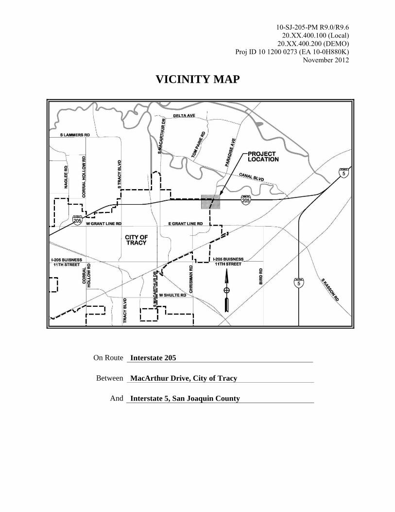
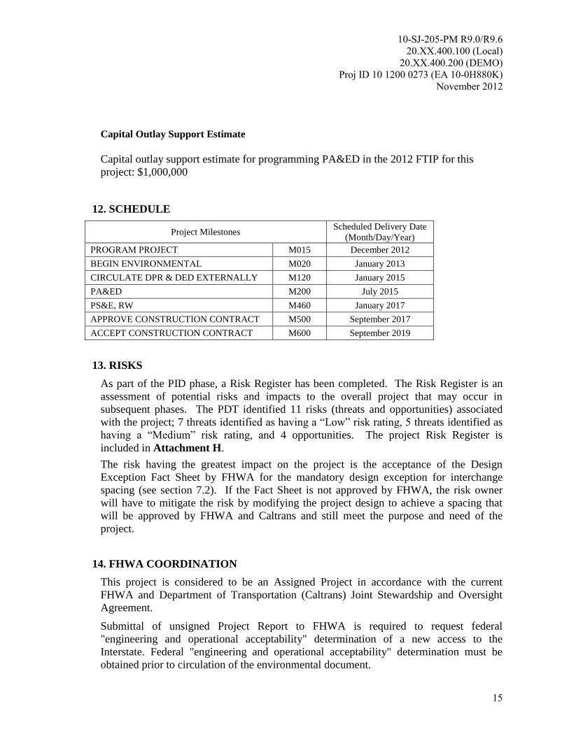
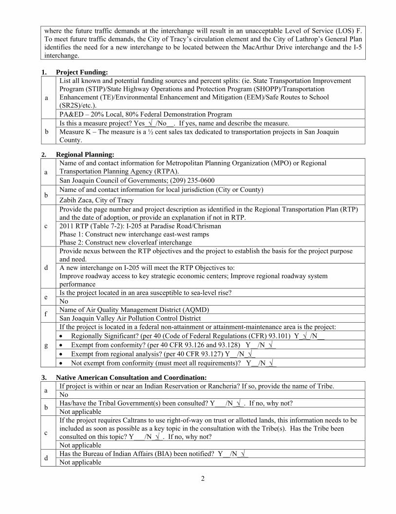
VICINITY MAP
On Route Interstate 205
Between MacArthur Drive, City of Tracy
And Interstate 5, San Joaquin County
10-SJ-205-PM R9.0/R9.6
20.XX.400.100 (Local)
20.XX.400.200 (DEMO)
Proj ID 10 1200 0273 (EA 10-0H880K)
November 2012
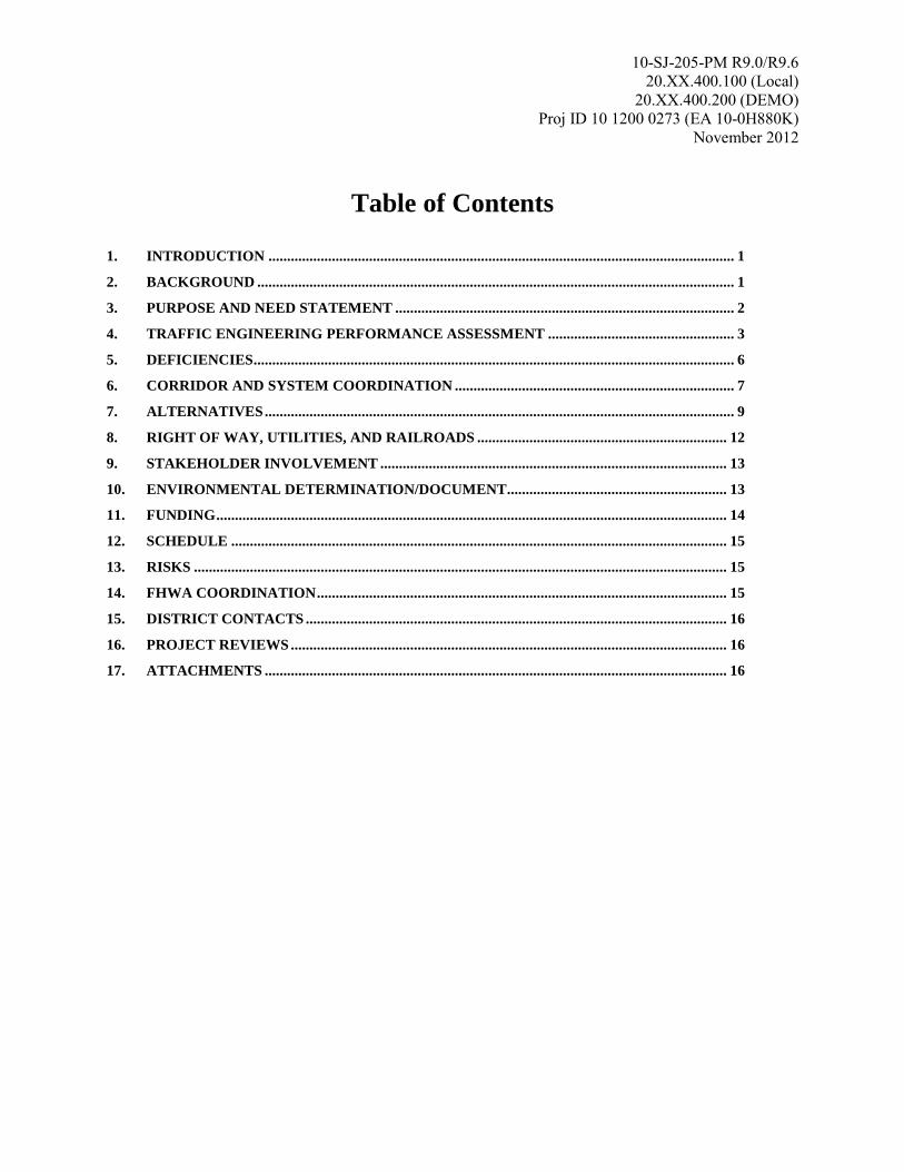
Table of Contents
1. INTRODUCTION ............................................................................................................................. 1
2. BACKGROUND ................................................................................................................................ 1
3. PURPOSE AND NEED STATEMENT ........................................................................................... 2
4. TRAFFIC ENGINEERING PERFORMANCE ASSESSMENT .................................................. 3
5. DEFICIENCIES ................................................................................................................................. 6
6. CORRIDOR AND SYSTEM COORDINATION ........................................................................... 7
7. ALTERNATIVES .............................................................................................................................. 9
8. RIGHT OF WAY, UTILITIES, AND RAILROADS ................................................................... 12
9. STAKEHOLDER INVOLVEMENT ............................................................................................. 13
10. ENVIRONMENTAL DETERMINATION/DOCUMENT ........................................................... 13
11. FUNDING ......................................................................................................................................... 14
12. SCHEDULE ..................................................................................................................................... 15
13. RISKS ............................................................................................................................................... 15
14. FHWA COORDINATION .............................................................................................................. 15
15. DISTRICT CONTACTS ................................................................................................................. 16
16. PROJECT REVIEWS ..................................................................................................................... 16
17. ATTACHMENTS ............................................................................................................................ 16
10-SJ-205-PM R9.0/R9.6
20.XX.400.100 (Local)
20.XX.400.200 (DEMO)
Proj ID 10 1200 0273 (EA 10-0H880K)
November 2012
1
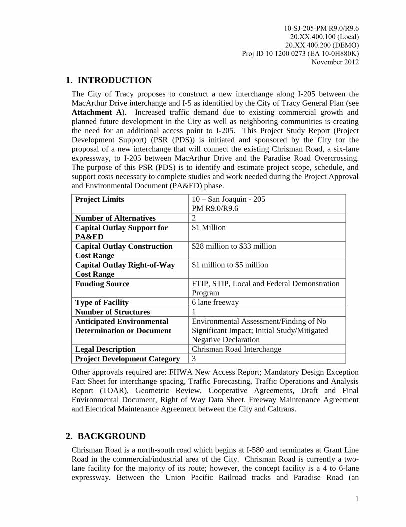
1. INTRODUCTION
The City of Tracy proposes to construct a new interchange along I-205 between the
MacArthur Drive interchange and I-5 as identified by the City of Tracy General Plan (see
Attachment A). Increased traffic demand due to existing commercial growth and
planned future development in the City as well as neighboring communities is creating
the need for an additional access point to I-205. This Project Study Report (Project
Development Support) (PSR (PDS)) is initiated and sponsored by the City for the
proposal of a new interchange that will connect the existing Chrisman Road, a six-lane
expressway, to I-205 between MacArthur Drive and the Paradise Road Overcrossing.
The purpose of this PSR (PDS) is to identify and estimate project scope, schedule, and
support costs necessary to complete studies and work needed during the Project Approval
and Environmental Document (PA&ED) phase.
Project Limits 10 – San Joaquin - 205
PM R9.0/R9.6
Number of Alternatives 2
Capital Outlay Support for
PA&ED
$1 Million
Capital Outlay Construction
Cost Range
$28 million to $33 million
Capital Outlay Right-of-Way
Cost Range
$1 million to $5 million
Funding Source FTIP, STIP, Local and Federal Demonstration
Program
Type of Facility 6 lane freeway
Number of Structures 1
Anticipated Environmental
Determination or Document
Environmental Assessment/Finding of No
Significant Impact; Initial Study/Mitigated
Negative Declaration
Legal Description Chrisman Road Interchange
Project Development Category 3
Other approvals required are: FHWA New Access Report; Mandatory Design Exception
Fact Sheet for interchange spacing, Traffic Forecasting, Traffic Operations and Analysis
Report (TOAR), Geometric Review, Cooperative Agreements, Draft and Final
Environmental Document, Right of Way Data Sheet, Freeway Maintenance Agreement
and Electrical Maintenance Agreement between the City and Caltrans.
2. BACKGROUND
Chrisman Road is a north-south road which begins at I-580 and terminates at Grant Line
Road in the commercial/industrial area of the City. Chrisman Road is currently a two-
lane facility for the majority of its route; however, the concept facility is a 4 to 6-lane
expressway. Between the Union Pacific Railroad tracks and Paradise Road (an
10-SJ-205-PM R9.0/R9.6
20.XX.400.100 (Local)
20.XX.400.200 (DEMO)
Proj ID 10 1200 0273 (EA 10-0H880K)
November 2012
2
approximately 2,000-foot segment) through the industrial area in the northeast quadrant
of the City, Chrisman Road is constructed to the ultimate 6 lane concept facility as a
condition to current businesses under the City’s industrial zoning.
Interstate 205 is an east-west route that serves as a connection between I-5 in San Joaquin
County to I-580 in Alameda County. I-205 is classified as a Principal Arterial Interstate
Freeway which primarily serves as a route for interregional recreation and commuter
traffic between the Bay Area and the Central Valley. A secondary purpose of I-205 is to
serve as a local route for commuter trips in the City area. The majority of I-205 is a rural
freeway except where it passes through the urban City area. Within the project limits, I-
205 is a six lane freeway (recently widened in October 2009) with three mixed flow lanes
in each direction separated by an unpaved, depressed median.
The proposed project contains features that will make it consistent with the context of its
surroundings and that provide efficient mobility for all users in accordance with the
guidelines in Deputy Directive 64.
The project sponsor, the City of Tracy, has been actively involved in the development of
the purpose and need of the project through their participation in Project Development
Team meetings and their overall coordination of the project development process.
The City of Tracy and Caltrans are working on a Cooperative Agreement for Caltrans to
provide oversight during the PA&ED phase.
3. PURPOSE AND NEED STATEMENT
3.1 Purpose
The purpose of the project is to:
Provide a new connection to I-205 that serves the existing and planned residential,
commercial and industrial development in the vicinity;
Relieve the forecasted increase in traffic demand at surrounding interchanges; and
Increase regional mobility.
3.2 Need
The northeast area of Tracy and its surrounding communities (particularly southwest
Lathrop) are currently growing and developing. This is expected to continue and increase
over the next few decades. This growth will continue to increase the demand on local
interchanges causing them to operate at a less than acceptable Level of Service (LOS).
The closest access to I-205 from the project site is MacArthur Drive where the future
traffic demands at the interchange will result in an unacceptable LOS F. To meet future
traffic demands, the City of Tracy’s circulation element and the City of Lathrop’s
General Plan identify the need for a new interchange to be located on I-205 between the
10-SJ-205-PM R9.0/R9.6
20.XX.400.100 (Local)
20.XX.400.200 (DEMO)
Proj ID 10 1200 0273 (EA 10-0H880K)
November 2012
3
MacArthur Drive interchange and the I-5 interchange. The proposed location of the new
interchange is located at or near the Paradise Road Overcrossing, which is between the
MacArthur Drive interchange and the I-5 interchange.
4. TRAFFIC ENGINEERING PERFORMANCE ASSESSMENT
During this phase of the project, a Traffic Engineering Performance Assessment (TEPA)
study was performed. This study is an assessment of existing traffic data and a macro-
level analysis. The intent is to identify potential benefits and deficiencies of the proposed
project and establish a potential scope of work needed for traffic analysis during the next
phase (PA&ED). Eventually detailed traffic studies and analysis will be completed
during the PA&ED phase to demonstrate how each alternative meets the project’s
purpose and need.
4.1 Summary of Preliminary Findings and Recommendations
Two readily available traffic studies were used as a basis for forecasting traffic for the
design year 2040 for both intersection and I-205 mainline operations: the Citywide
Roadway and Transportation Master Plan for the City of Tracy, August 2011 (Roadway
Master Plan) and the Interstate 205 and Interstate 5 High Occupancy Toll (HOT) Lane
Feasibility Review, May 2011 (HOT Study).
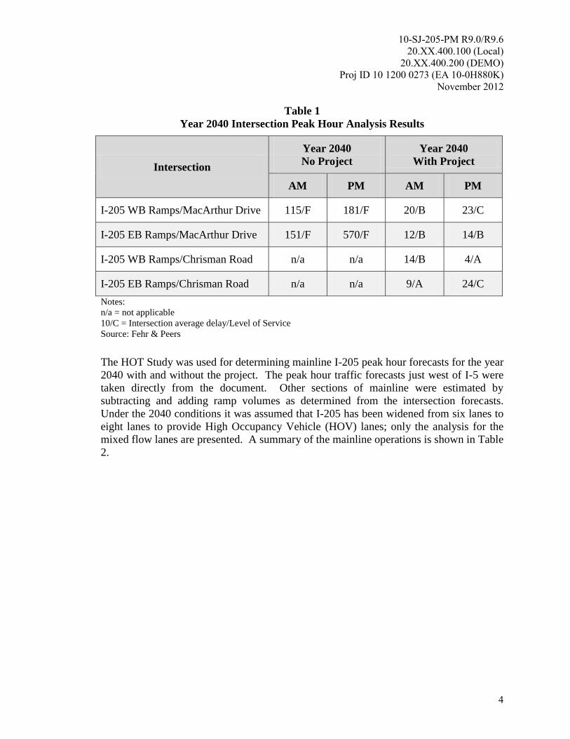
The Roadway Master Plan provided intersection peak hour volumes for existing
conditions and the year 2035 conditions. Applying a yearly growth rate, intersection
volumes for the I-205/MacArthur Drive and the then completed I-205/Chrisman Road
interchanges for the year 2040. Based on the preliminary analysis, all intersections
studied will operate an unacceptable LOS F under No Project conditions and will operate
at an acceptable LOS C or better under year 2040 With Project conditions, as shown in
Table 1.
10-SJ-205-PM R9.0/R9.6
20.XX.400.100 (Local)
20.XX.400.200 (DEMO)
Proj ID 10 1200 0273 (EA 10-0H880K)
November 2012
4
Table 1
Year 2040 Intersection Peak Hour Analysis Results
Intersection
Year 2040
No Project
Year 2040
With Project
AM PM AM PM
I-205 WB Ramps/MacArthur Drive 115/F 181/F 20/B 23/C
I-205 EB Ramps/MacArthur Drive 151/F 570/F 12/B 14/B
I-205 WB Ramps/Chrisman Road n/a n/a 14/B 4/A
I-205 EB Ramps/Chrisman Road n/a n/a 9/A 24/C
Notes:
n/a = not applicable
10/C = Intersection average delay/Level of Service
Source: Fehr & Peers
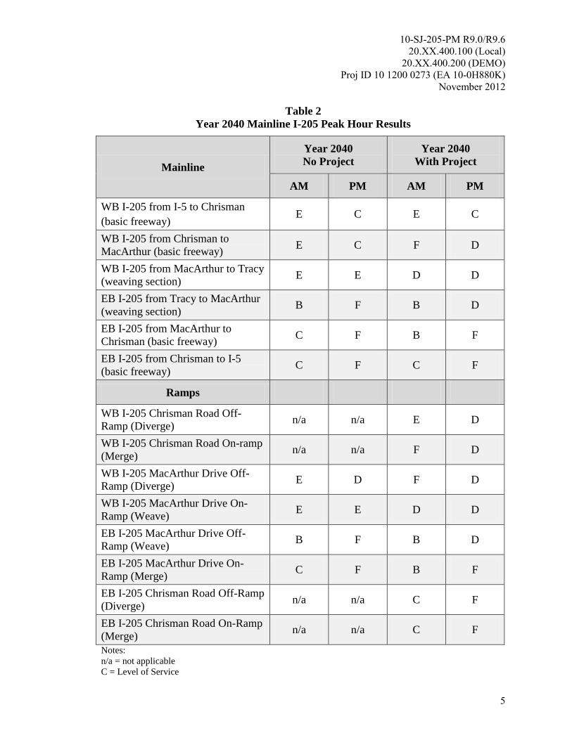
The HOT Study was used for determining mainline I-205 peak hour forecasts for the year
2040 with and without the project. The peak hour traffic forecasts just west of I-5 were
taken directly from the document. Other sections of mainline were estimated by
subtracting and adding ramp volumes as determined from the intersection forecasts.
Under the 2040 conditions it was assumed that I-205 has been widened from six lanes to
eight lanes to provide High Occupancy Vehicle (HOV) lanes; only the analysis for the
mixed flow lanes are presented. A summary of the mainline operations is shown in Table
2.
10-SJ-205-PM R9.0/R9.6
20.XX.400.100 (Local)
20.XX.400.200 (DEMO)
Proj ID 10 1200 0273 (EA 10-0H880K)
November 2012
5
Table 2
Year 2040 Mainline I-205 Peak Hour Results
Mainline
Year 2040
No Project
Year 2040
With Project
AM PM AM PM
WB I-205 from I-5 to Chrisman
(basic freeway) E C E C
WB I-205 from Chrisman to
MacArthur (basic freeway) E C F D
WB I-205 from MacArthur to Tracy
(weaving section) E E D D
EB I-205 from Tracy to MacArthur
(weaving section) B F B D
EB I-205 from MacArthur to
Chrisman (basic freeway) C F B F
EB I-205 from Chrisman to I-5
(basic freeway) C F C F
Ramps
WB I-205 Chrisman Road Off-
Ramp (Diverge) n/a n/a E D
WB I-205 Chrisman Road On-ramp
(Merge) n/a n/a F D
WB I-205 MacArthur Drive Off-
Ramp (Diverge) E D F D
WB I-205 MacArthur Drive On-
Ramp (Weave) E E D D
EB I-205 MacArthur Drive Off-
Ramp (Weave) B F B D
EB I-205 MacArthur Drive On-
Ramp (Merge) C F B F
EB I-205 Chrisman Road Off-Ramp
(Diverge) n/a n/a C F
EB I-205 Chrisman Road On-Ramp
(Merge) n/a n/a C F
Notes:
n/a = not applicable
C = Level of Service
10-SJ-205-PM R9.0/R9.6
20.XX.400.100 (Local)
20.XX.400.200 (DEMO)
Proj ID 10 1200 0273 (EA 10-0H880K)
November 2012
6
Source: Fehr & Peers
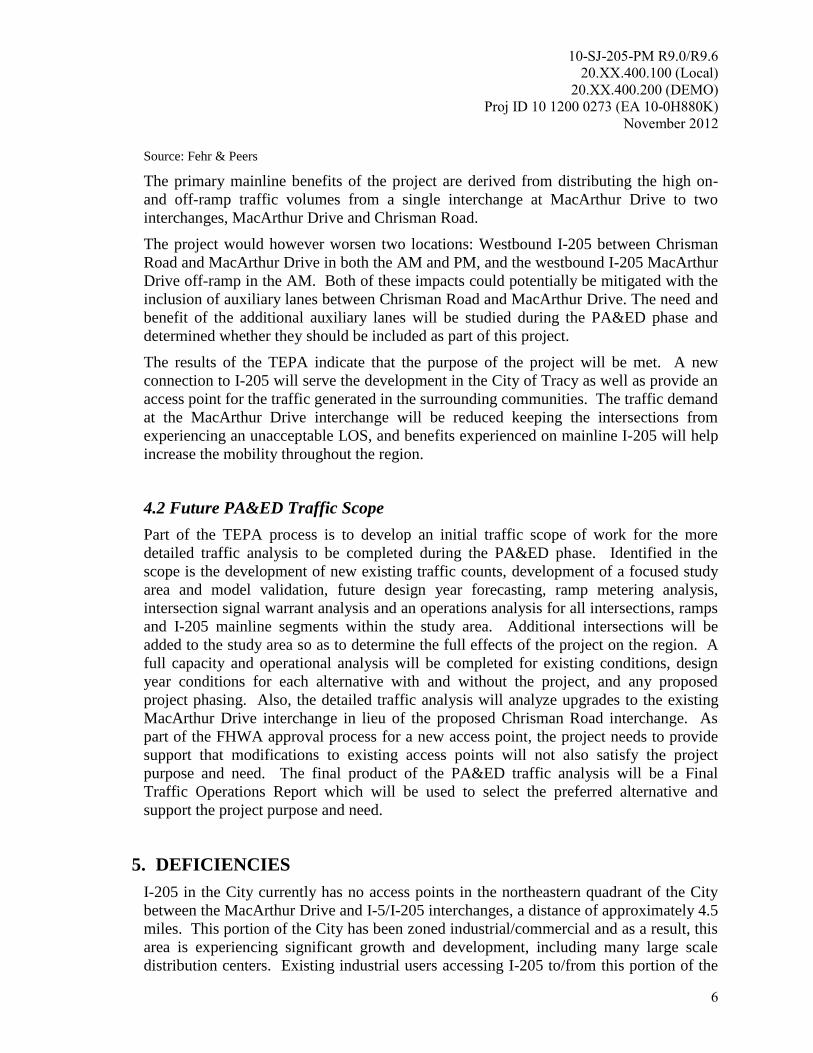
The primary mainline benefits of the project are derived from distributing the high on-
and off-ramp traffic volumes from a single interchange at MacArthur Drive to two
interchanges, MacArthur Drive and Chrisman Road.
The project would however worsen two locations: Westbound I-205 between Chrisman
Road and MacArthur Drive in both the AM and PM, and the westbound I-205 MacArthur
Drive off-ramp in the AM. Both of these impacts could potentially be mitigated with the
inclusion of auxiliary lanes between Chrisman Road and MacArthur Drive. The need and
benefit of the additional auxiliary lanes will be studied during the PA&ED phase and
determined whether they should be included as part of this project.
The results of the TEPA indicate that the purpose of the project will be met. A new
connection to I-205 will serve the development in the City of Tracy as well as provide an
access point for the traffic generated in the surrounding communities. The traffic demand
at the MacArthur Drive interchange will be reduced keeping the intersections from
experiencing an unacceptable LOS, and benefits experienced on mainline I-205 will help
increase the mobility throughout the region.
4.2 Future PA&ED Traffic Scope
Part of the TEPA process is to develop an initial traffic scope of work for the more
detailed traffic analysis to be completed during the PA&ED phase. Identified in the
scope is the development of new existing traffic counts, development of a focused study
area and model validation, future design year forecasting, ramp metering analysis,
intersection signal warrant analysis and an operations analysis for all intersections, ramps
and I-205 mainline segments within the study area. Additional intersections will be
added to the study area so as to determine the full effects of the project on the region. A
full capacity and operational analysis will be completed for existing conditions, design
year conditions for each alternative with and without the project, and any proposed
project phasing. Also, the detailed traffic analysis will analyze upgrades to the existing
MacArthur Drive interchange in lieu of the proposed Chrisman Road interchange. As
part of the FHWA approval process for a new access point, the project needs to provide
support that modifications to existing access points will not also satisfy the project
purpose and need. The final product of the PA&ED traffic analysis will be a Final
Traffic Operations Report which will be used to select the preferred alternative and
support the project purpose and need.
5. DEFICIENCIES
I-205 in the City currently has no access points in the northeastern quadrant of the City
between the MacArthur Drive and I-5/I-205 interchanges, a distance of approximately 4.5
miles. This portion of the City has been zoned industrial/commercial and as a result, this
area is experiencing significant growth and development, including many large scale
distribution centers. Existing industrial users accessing I-205 to/from this portion of the
10-SJ-205-PM R9.0/R9.6
20.XX.400.100 (Local)
20.XX.400.200 (DEMO)
Proj ID 10 1200 0273 (EA 10-0H880K)
November 2012
7
City utilize the MacArthur Drive interchange since it is the nearest freeway access point.
Along with the growth to this commercial district, neighboring communities are also
planning large developments. The City of Lathrop is planning to build a community
north of I-205 which will have over 4,000 homes and 3 million square feet of commercial
property. This community has planned connectivity to the City via the proposed
Chrisman Road Interchange as identified in the General Plan for the City of Lathrop and
the 2003 West Lathrop Specific Plan.
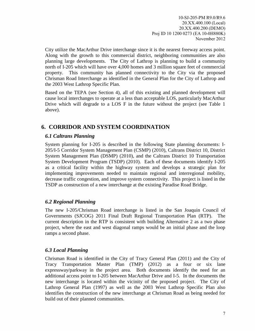
Based on the TEPA (see Section 4), all of this existing and planned development will
cause local interchanges to operate at a less than acceptable LOS, particularly MacArthur
Drive which will degrade to a LOS F in the future without the project (see Table 1
above).
6. CORRIDOR AND SYSTEM COORDINATION
6.1 Caltrans Planning
System planning for I-205 is described in the following State planning documents: I-
205/I-5 Corridor System Management Plan (CSMP) (2010), Caltrans District 10, District
System Management Plan (DSMP) (2010), and the Caltrans District 10 Transportation
System Development Program (TSDP) (2010). Each of these documents identify I-205
as a critical facility within the highway system and develops a strategic plan for
implementing improvements needed to maintain regional and interregional mobility,
decrease traffic congestion, and improve system connectivity. This project is listed in the
TSDP as construction of a new interchange at the existing Paradise Road Bridge.
6.2 Regional Planning
The new I-205/Chrisman Road interchange is listed in the San Joaquin Council of
Governments (SJCOG) 2011 Final Draft Regional Transportation Plan (RTP). The
current description in the RTP is consistent with building Alternative 2 as a two phase
project, where the east and west diagonal ramps would be an initial phase and the loop
ramps a second phase.
6.3 Local Planning
Chrisman Road is identified in the City of Tracy General Plan (2011) and the City of
Tracy Transportation Master Plan (TMP) (2012) as a four or six lane
expressway/parkway in the project area. Both documents identify the need for an
additional access point to I-205 between MacArthur Drive and I-5. In the documents the
new interchange is located within the vicinity of the proposed project. The City of
Lathrop General Plan (1997) as well as the 2003 West Lathrop Specific Plan also
identifies the construction of the new interchange at Chrisman Road as being needed for
build out of their planned communities.
10-SJ-205-PM R9.0/R9.6
20.XX.400.100 (Local)
20.XX.400.200 (DEMO)
Proj ID 10 1200 0273 (EA 10-0H880K)
November 2012
8
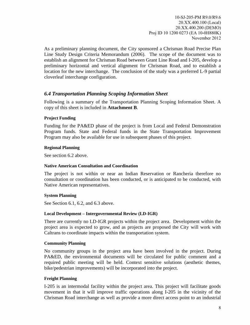
As a preliminary planning document, the City sponsored a Chrisman Road Precise Plan
Line Study Design Criteria Memorandum (2006). The scope of the document was to
establish an alignment for Chrisman Road between Grant Line Road and I-205, develop a
preliminary horizontal and vertical alignment for Chrisman Road, and to establish a
location for the new interchange. The conclusion of the study was a preferred L-9 partial
cloverleaf interchange configuration.
6.4 Transportation Planning Scoping Information Sheet
Following is a summary of the Transportation Planning Scoping Information Sheet. A
copy of this sheet is included in Attachment B.
Project Funding
Funding for the PA&ED phase of the project is from Local and Federal Demonstration
Program funds. State and Federal funds in the State Transportation Improvement
Program may also be available for use in subsequent phases of this project.
Regional Planning
See section 6.2 above.
Native American Consultation and Coordination
The project is not within or near an Indian Reservation or Rancheria therefore no
consultation or coordination has been conducted, or is anticipated to be conducted, with
Native American representatives.
System Planning
See Section 6.1, 6.2, and 6.3 above.
Local Development – Intergovernmental Review (LD-IGR)
There are currently no LD-IGR projects within the project area. Development within the
project area is expected to grow, and as projects are proposed the City will work with
Caltrans to coordinate impacts within the transportation system.
Community Planning
No community groups in the project area have been involved in the project. During
PA&ED, the environmental documents will be circulated for public comment and a
required public meeting will be held. Context sensitive solutions (aesthetic themes,
bike/pedestrian improvements) will be incorporated into the project.
Freight Planning
I-205 is an intermodal facility within the project area. This project will facilitate goods
movement in that it will improve traffic operations along I-205 in the vicinity of the
Chrisman Road interchange as well as provide a more direct access point to an industrial
10-SJ-205-PM R9.0/R9.6
20.XX.400.100 (Local)
20.XX.400.200 (DEMO)
Proj ID 10 1200 0273 (EA 10-0H880K)
November 2012
9
area that serves as a destination for truck traffic. No special features are anticipated to be
needed for truck traffic as part of this project.
Transit
San Joaquin Regional Transit District (SJRTD) and Tracer Transit (City of Tracy)
provide transit services within the project area. No new transit facilities are anticipated
with the project and impacts to transit during construction will be addressed during Final
Design. The transit agencies will be contacted during PA&ED for coordination.
Bicycle
Bicycle facilities will be provided on Chrisman Road per the City of Tracy TMP and the
City of Tracy Bikeways Master Plan (2005). All freeway on- and off-ramps will be
squared up with Chrisman Road to provide safe bicycle crossing at intersections.
Pedestrian
Pedestrian facilities will be provided as identified by the City of Tracy TMP. All
pedestrian facilities including sidewalks, curb ramps and cross walks will be compliant
with American with Disabilities Act (ADA) requirements.
Equestrian
There is no equestrian demand or facilities in the area. As such, accommodations for
equestrian traffic are not needed for this project.
Intelligent Transportation System (ITS)
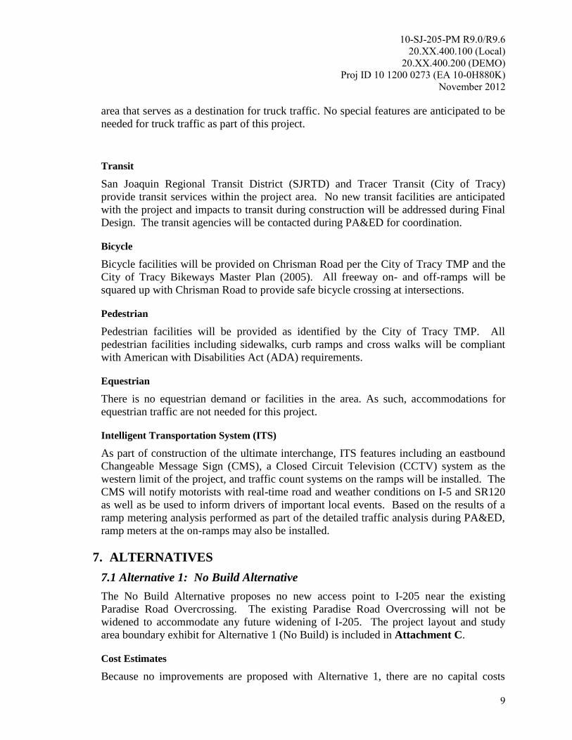
As part of construction of the ultimate interchange, ITS features including an eastbound
Changeable Message Sign (CMS), a Closed Circuit Television (CCTV) system as the
western limit of the project, and traffic count systems on the ramps will be installed. The
CMS will notify motorists with real-time road and weather conditions on I-5 and SR120
as well as be used to inform drivers of important local events. Based on the results of a
ramp metering analysis performed as part of the detailed traffic analysis during PA&ED,
ramp meters at the on-ramps may also be installed.
7. ALTERNATIVES
7.1 Alternative 1: No Build Alternative
The No Build Alternative proposes no new access point to I-205 near the existing
Paradise Road Overcrossing. The existing Paradise Road Overcrossing will not be
widened to accommodate any future widening of I-205. The project layout and study
area boundary exhibit for Alternative 1 (No Build) is included in Attachment C.
Cost Estimates
Because no improvements are proposed with Alternative 1, there are no capital costs
10-SJ-205-PM R9.0/R9.6
20.XX.400.100 (Local)
20.XX.400.200 (DEMO)
Proj ID 10 1200 0273 (EA 10-0H880K)
November 2012
10
associated with it.
Required Approvals
The No-Build alternative will not change existing conditions and will therefore not
require any approvals.
Stormwater
Because no improvements are proposed with Alternative 1, no stormwater Best
Management Practices (BMPs) will be implemented.
Context Sensitive Solutions/Complete Streets
Because no improvements are proposed with Alternative 1, no context sensitive solutions
or improvements providing for safe multimodal mobility will be implemented.
Constructability
Because no improvements are proposed with Alternative 1, there are no constructability
issues associated with this alternative.
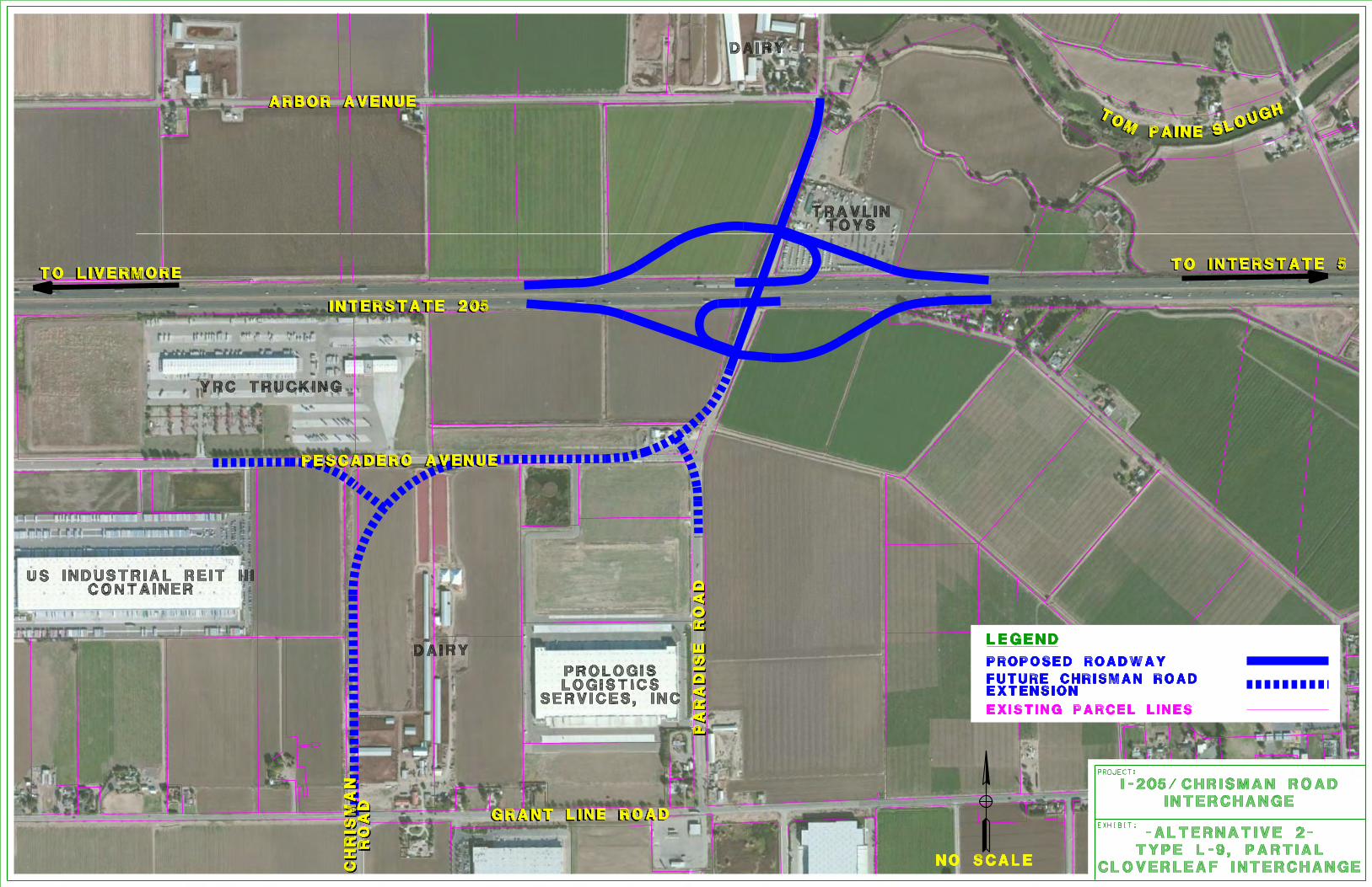
7.2 Alternative 2: L-9 Partial Cloverleaf
Alternative 2, shown in Attachment C, proposes to construct a new interchange between
MacArthur Dive and I-5 at the approximate location of the existing Paradise Road
Overcrossing. The proposed interchange configuration will be a partial cloverleaf (Type
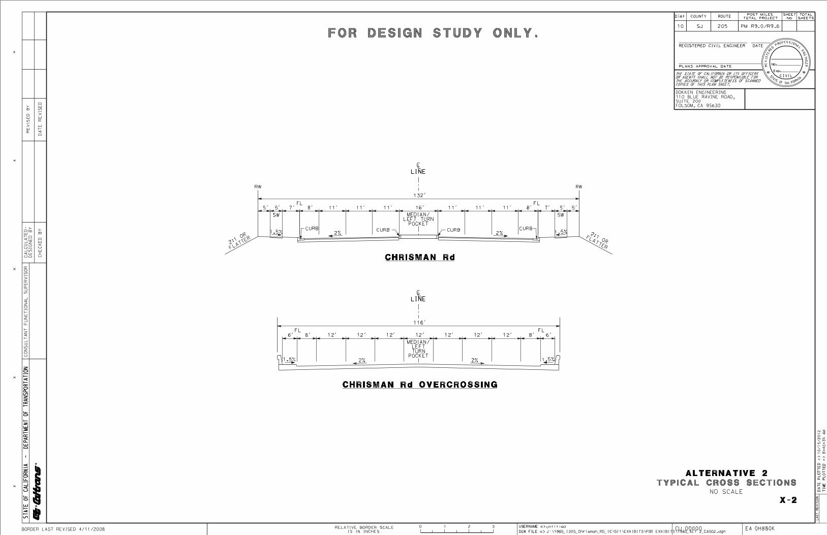
L-9) which includes four diamond-type ramps and two loop on-ramps. The overcrossing
structure will accommodate six traveled lanes, shoulders and sidewalks, and will
accommodate the future widening of I-205 to a ten-lane ultimate facility. Each of the
ramp intersections will be signalized. The interchange will tie into the existing Paradise
Road on both the north and south sides of the interstate. The construction of the
interchange will require the existing Paradise Road Overcrossing to be removed. As part
of a future project, the City will extend Chrisman Road at Grant Line Road north to
connect to the project. New local intersections for Pescadero Road and Paradise Road
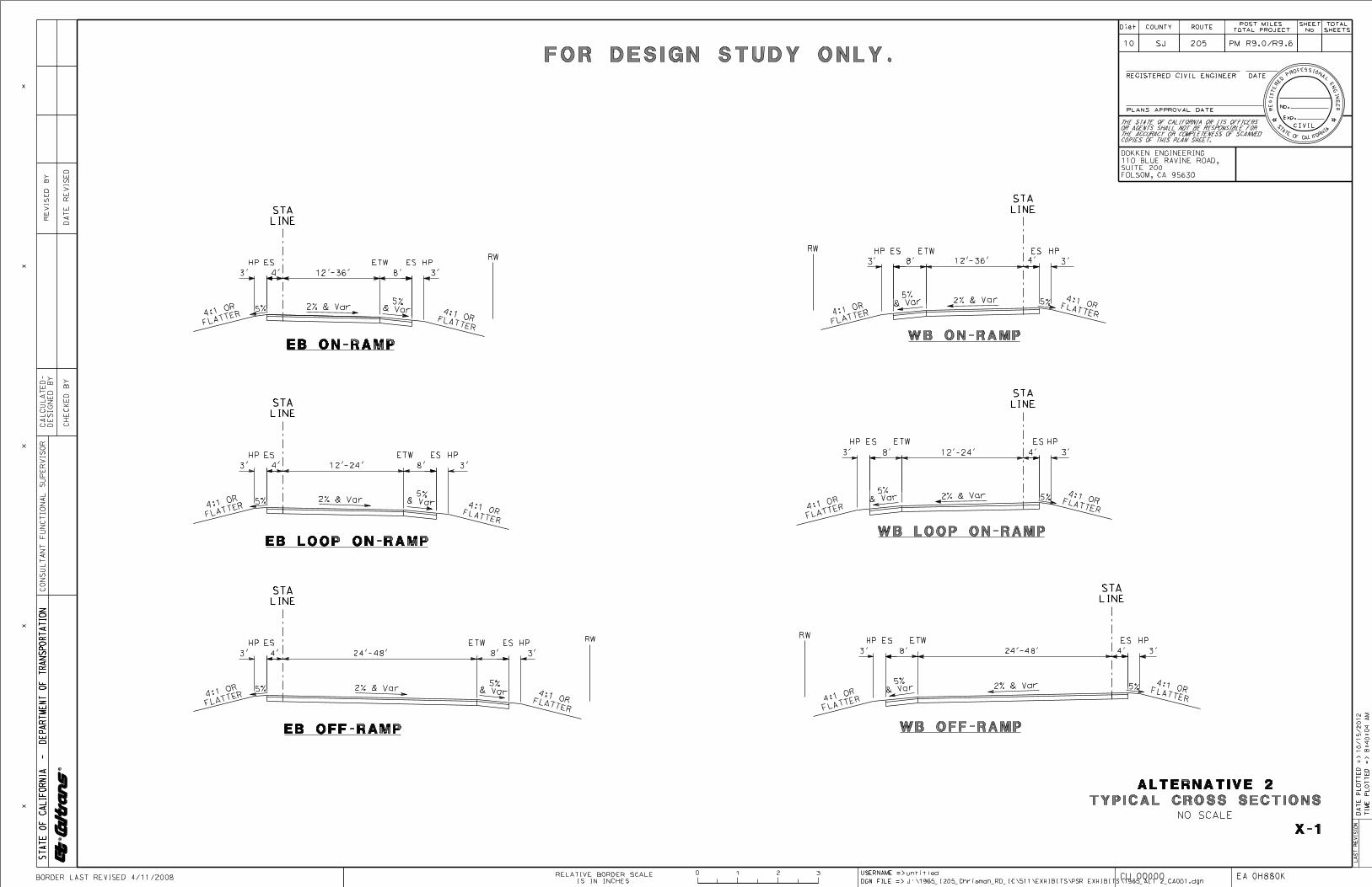
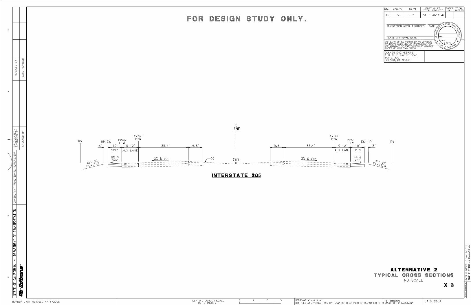
will be constructed on the Chrisman Road extension. Typical cross sections for
Alternative 2 are shown in Attachment D.
A benefit to the proposed Type L-9 interchange configuration is the ability to phase the
construction as the future traffic demand requires additional capacity and as funding
becomes available. The initial interchange can be built with only the four east-west
diamond-type on- and off-ramps in their ultimate location, and the interior loop on-ramps
can be constructed in a second phase. Ultimate right-of-way would be acquired with the
first phase for the construction of the diamond ramps. This phasing strategy is consistent
with the SJCOG 2011 RTP for the I-205 at Paradise Road/Chrisman Road interchange
with the initial Phase 1 construction being a Tier I project (highest priority) and Phase 2
being a Tier II project (additional regionally important project but which is not able to be
funded at the current time).

10-SJ-205-PM R9.0/R9.6
20.XX.400.100 (Local)
20.XX.400.200 (DEMO)
Proj ID 10 1200 0273 (EA 10-0H880K)
November 2012
11
Cost Estimates
The estimated total project cost for Alternative 2, including right of way and
construction, is approximately $29 million to $38 million (in escalated dollars). The
estimated PA&ED support cost is approximately $1,000,000. A cost estimate breakdown
for Alternative 2 is included in Attachment E.
Non-Standard Design Features
The following mandatory design exceptions will be required to obtain project approval of
Alternative 2:
Non-Standard Interchange Spacing (Highway Design Manual (HDM) 201.3,
“Spacing”) – The minimum interchange spacing on Interstates outside of a
Transportation Management Area (TMA) shall be three miles. A TMA is defined
by the Federal Highway Administration (FHWA) as an urban area with a
population greater than 200,000 people. The project location does not lie within a
defined FHWA TMA. The proposed interchange spacing for the project is 1.5
miles to MacArthur Drive and 3.0 miles to I-5. The required interchange spacing
is not attainable due to the distance between MacArthur Drive and I-5.
Non-Standard Lane Width (HDM 301, “Traveled Way Standards”) – The
minimum required lane width on multilane highways is 12 feet. The widening of
I-205 (EA 300161) was a metric project, making the existing travel lanes on
mainline 11.8 feet instead of the required 12 feet. The project does not propose
any work within the existing travel lanes of mainline I-205.
Non-Standard Shoulder Width (HDM 302, “Highway Shoulder Standards”) – The
minimum required left shoulder width for freeways of 6 or more lanes is 10 feet.
The widening of I-205 (EA 300161) was a metric project, making the existing left
shoulder width on mainline 9.8 feet instead of the required 10 feet. The project
does not propose any work within left shoulders of mainline I-205.
Required Approvals
Approval from FHWA will be required due to the new access proposed by this alternative
at I-205. This approval will be obtained through the submission of a New Access Report
during PA&ED.
Stormwater
Alternative 2 has the potential to increase the volume of runoff and the urban pollutant
load of this runoff due to the increase in impervious area. In addition, the project may
temporarily increase sediment load in the runoff due to the grading activities associated
with the project. To mitigate these impacts, temporary and permanent treatment Best
Management Practices (BMPs) will be incorporated into the project.
Temporary construction site BMPs anticipated to be used for this project include fiber
rolls for slope stability and sediment control, stabilized construction entrances to prevent
sediment tracking on paved surfaces, temporary drainage inlet protection, temporary
10-SJ-205-PM R9.0/R9.6
20.XX.400.100 (Local)
20.XX.400.200 (DEMO)
Proj ID 10 1200 0273 (EA 10-0H880K)
November 2012
12
concrete washouts for concrete spoils, street sweeping, temporary silt fences, temporary
check dams, temporary hydraulic mulch, tire/wheel washes, and covers for stockpiles
against wind erosion.
Permanent treatment BMPs that may be used for this project include infiltration and
detention basins, biofiltration swales and media filters.
Stormwater impacts will be further minimized by disturbing existing slopes only when
necessary, minimizing cut and fill areas, avoiding soils that will be difficult to re-
stabilize, providing slopes flat enough to re-vegetate, rounding slopes to reduce
concentrated flows and collecting concentrated flows in stabilized channels. The design
will allow for ease of maintenance. The project will be scheduled to minimize soil-
disturbing work during the rainy season. If applicable, permanent water pollution
controls will be installed early to be used during construction.
Context Sensitive Solutions/Complete Streets
Alternative 2 contains numerous features that provide for the safe mobility of all users,
including sidewalks, bike facilities, and ADA compliant grades and ramps.
In addition, the proposed project fits within the context of its surroundings in that the
structure type and aesthetic features will be consistent with those of the adjacent
interchanges and the provided cross sectional features (bike lanes, sidewalks, etc.) will be
consistent with those along the existing corridor.
Constructability
Construction of the interchange and roadways associated with Alternative 2 can be
accomplished with little disruption to I-205 and the local roadway network. Erection of
the falsework for the new structure, and demolition of the existing Paradise Road
Overcrossing will require a short term detour of traffic on I-205. A short term median
crossover or widening of the inside shoulders along I-205 is one option for detouring
mainline traffic since there are no adjacent ramps. Another method would be to construct
the proposed on and off-ramps in an initial stage so that they may be used to detour
traffic on and off I-205 for the falsework erection and demolition. Short term detours for
local road will also be necessary. No long term closures or detours are anticipated.
8. RIGHT OF WAY, UTILITIES, AND RAILROADS
8.1 Right of Way
Right of way acquisition will not be needed for Alternative 1.
Alternative 2 will require the acquisition of private property to accommodate the
interchange configuration. Right of way acquisition is required for each of the ramps, the
overcrossing and along Paradise Road. A Right Of Way Conceptual Cost Estimate for
the alternative is included in Attachment F.
10-SJ-205-PM R9.0/R9.6
20.XX.400.100 (Local)
20.XX.400.200 (DEMO)
Proj ID 10 1200 0273 (EA 10-0H880K)
November 2012
13
8.2 Utilities
The following utility companies have been determined to have facilities within the
project vicinity:
City of Tracy Public Works
AT&T
Comcast
PG&E
Pacific Bell
Pescadero Reclamation District
Further investigations will be performed during the PA&ED phase to determine the
types, location, and sizes all utilities.
No utilities will be impacted by Alternative 1.
Alternative 2 will require potholing to determine if underground utilities will require
relocation. For preliminary planning and estimating purposes, the presence of all the
above utility companies facilities are assumed to be impacted. Relocation of utilities, if
necessary, will be coordinated with the utility owners during the design process.
The agency responsible for the costs of any utility relocation will be determined based on
research of ownership, prior rights, and Master Agreements. Once this determination is
made, a “determination of liability” will be completed to appropriately allocate funds for
the design and relocation of the affected utilities.
8.3 Railroad
There are no railroad facilities in the project area. Therefore, none of the alternatives will
have impacts to railroad lines.
9. STAKEHOLDER INVOLVEMENT
Representatives of the City and Caltrans attended Project Development Team (PDT)
meetings during the Project Initiation Document (PID) phase to develop the need and
purpose and identify the alternatives studied for the I-205/Chrisman Road Interchange
Project. These meetings will continue during the PA&ED phase. Also during the
PA&ED phase, public meetings will be held as part of the environmental review process.
10. ENVIRONMENTAL DETERMINATION/DOCUMENT
Based on the results of the Preliminary Environmental Analysis Report (PEAR), included
as Attachment G, Alternative 2 is not expected to result in impacts that could not be
10-SJ-205-PM R9.0/R9.6
20.XX.400.100 (Local)
20.XX.400.200 (DEMO)
Proj ID 10 1200 0273 (EA 10-0H880K)
November 2012
14
mitigated to less than significant, as defined under the California Environmental Quality
Act (CEQA). Additionally, the proposed project is not likely to result in adverse impacts
pursuant to the National Environmental Protection Act (NEPA). Because the proposed
project is not foreseen to have significant impacts, the NEPA environmental document
for the project is anticipated to be an Environmental Assessment (EA) leading to a
Finding of No Significant Impact (FONSI). The appropriate level of environmental
documentation for CEQA is anticipated to be an Initial Study (IS), leading to a Mitigated
Negative Declaration (MND). The appropriate and ultimate level of CEQA and NEPA
environmental documentation would be determined upon completion of the required
supporting environmental technical studies for this project. Caltrans would be the Lead
Agency for CEQA compliance and also the Lead Agency for administering the
environmental process under NEPA. Effective July 1, 2007, Caltrans has been assigned
the environmental review and consultation responsibilities under NEPA pursuant to 23
U.S.C. 327.
To determine potential environmental impacts of the alternatives, the following technical
studies are recommended: Visual Impact Assessment; Historical Property Survey Report
(HPSR), Archaeological Survey Report (ASR); Traffic Study Report; Hazardous Waste
(Initial Site Assessment), Preliminary Site Investigation; Air Quality Report; Air Quality
Conformity Analysis; Noise Study Report; Natural Environment Study (NES); habitat
assessments (for pertinent species).
Habitat mitigation, aesthetic treatment, and air quality permits for construction are
anticipated for Alternative 2. Sound walls may also be required for the Alternative 2
based on results of the noise technical studies.
A National Pollutant Discharge Elimination System (NPDES) General Permit for
Discharges of Storm Water Associated with Construction Activity from the State Water
Resources Control Board (SWRCB) would be required for Alternative 2, and would
include a Storm Water Pollution Prevention Plan (SWPPP). Alternative 2 would also
require certification of a Water Quality Management Plan (WQMP) from the City of
Tracy.
11. FUNDING
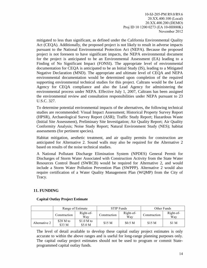
Capital Outlay Project Estimate
Range of Estimate STIP Funds Other Funds
Construction Right-of-
Way Construction
Right-of-
Way Construction
Right-of-
Way
Alternative 2 $28 M to
$33 M
$1.0 M to
$5.0 M $15 M $0.5 M $15 M $1 M
The level of detail available to develop these capital outlay project estimates is only
accurate to within the above ranges and is useful for long-range planning purposes only.
The capital outlay project estimates should not be used to program or commit State-
programmed capital outlay funds.
10-SJ-205-PM R9.0/R9.6
20.XX.400.100 (Local)
20.XX.400.200 (DEMO)
Proj ID 10 1200 0273 (EA 10-0H880K)
November 2012
15
Capital Outlay Support Estimate
Capital outlay support estimate for programming PA&ED in the 2012 FTIP for this
project: $1,000,000
12. SCHEDULE
Project Milestones Scheduled Delivery Date
(Month/Day/Year)
PROGRAM PROJECT M015 December 2012
BEGIN ENVIRONMENTAL M020 January 2013
CIRCULATE DPR & DED EXTERNALLY M120 January 2015
PA&ED M200 July 2015
PS&E, RW M460 January 2017
APPROVE CONSTRUCTION CONTRACT M500 September 2017
ACCEPT CONSTRUCTION CONTRACT M600 September 2019
13. RISKS
As part of the PID phase, a Risk Register has been completed. The Risk Register is an
assessment of potential risks and impacts to the overall project that may occur in
subsequent phases. The PDT identified 11 risks (threats and opportunities) associated
with the project; 7 threats identified as having a “Low” risk rating, 5 threats identified as
having a “Medium” risk rating, and 4 opportunities. The project Risk Register is
included in Attachment H.
The risk having the greatest impact on the project is the acceptance of the Design
Exception Fact Sheet by FHWA for the mandatory design exception for interchange
spacing (see section 7.2). If the Fact Sheet is not approved by FHWA, the risk owner
will have to mitigate the risk by modifying the project design to achieve a spacing that
will be approved by FHWA and Caltrans and still meet the purpose and need of the
project.
14. FHWA COORDINATION
This project is considered to be an Assigned Project in accordance with the current
FHWA and Department of Transportation (Caltrans) Joint Stewardship and Oversight
Agreement.
Submittal of unsigned Project Report to FHWA is required to request federal
"engineering and operational acceptability" determination of a new access to the
Interstate. Federal "engineering and operational acceptability" determination must be
obtained prior to circulation of the environmental document.
10-SJ-205-PM R9.0/R9.6
20.XX.400.100 (Local)
20.XX.400.200 (DEMO)
Proj ID 10 1200 0273 (EA 10-0H880K)
November 2012
16
Sufficient funding is expected to be reasonably available at the time of approval of the
environmental document to allow for the inclusion of the fully funded preferred
alternative in the financially constrained Metropolitan Planning Organization (MPO)
RTP/Federal Transportation Improvement Program (FTIP). In addition to the proposed
funding sources listed in Section 11, “FUNDING”, opportunities to receive Congestion
Mitigation and Air Quality (CMAQ) Improvement Program funds will be pursued during
subsequent project phases.
15. DISTRICT CONTACTS
Caltrans, District 10
Christina Hibbard, MA, PMP, Project Manager, (209) 948-7889
Michael Hutchinson, PE, Senior Oversight Engineer (209) 948-3976
Scott Smith, Senior Environmental Planner, (559) 445-6472
Vu H Nguyen, Chief, Traffic Operations, (209) 603-5126
George Fernandez, Right of Way, (209) 948-3969
Andrew Pochwatka, Stormwater, (559) 948-3969
City of Tracy
Zabih Zaca, Project Manager, (209) 831-6452
Dokken Engineering
Juann Ramos, Project Manager, (916) 858-0642
16. PROJECT REVIEWS
Field Review PDT agreed to use photos in lieu of field visit Date 02/07/2012
District Maintenance Date 09/06/2012
District Safety Review Date 09/06/2012
HQ Design Coordinator Date 09/06/2012
Project Manager District Safety Review Date 09/06/2012
Constructability Review Date 09/06/2012
17. ATTACHMENTS
A. Vicinity Map
B. Transportation Planning Scoping Information Sheet
C. Plan View Exhibits For Alternatives 1 and 2
D. Typical Cross Sections For Alternative 2
E. Cost Estimates For Alternative 2
F. Conceptual Cost Estimate – Right of Way Component
G. Preliminary Environmental Analysis Report (PEAR)

10-SJ-205-PM R9.0/R9.6
20.XX.400.100 (Local)
20.XX.400.200 (DEMO)
Proj ID 10 1200 0273 (EA 10-0H880K)
November 2012
17
H. Risk Register
I. Storm Water Data Report (SWDR) Cover Page

ATTACHMENT A
Vicinity Map

Vicinity Map
On Interstate 205 from 0.9 miles east of MacArthur Drive
to 2.9 miles west of Interstate 5
ATTACHMENT B
Transportation Planning Scoping Information Sheet
1
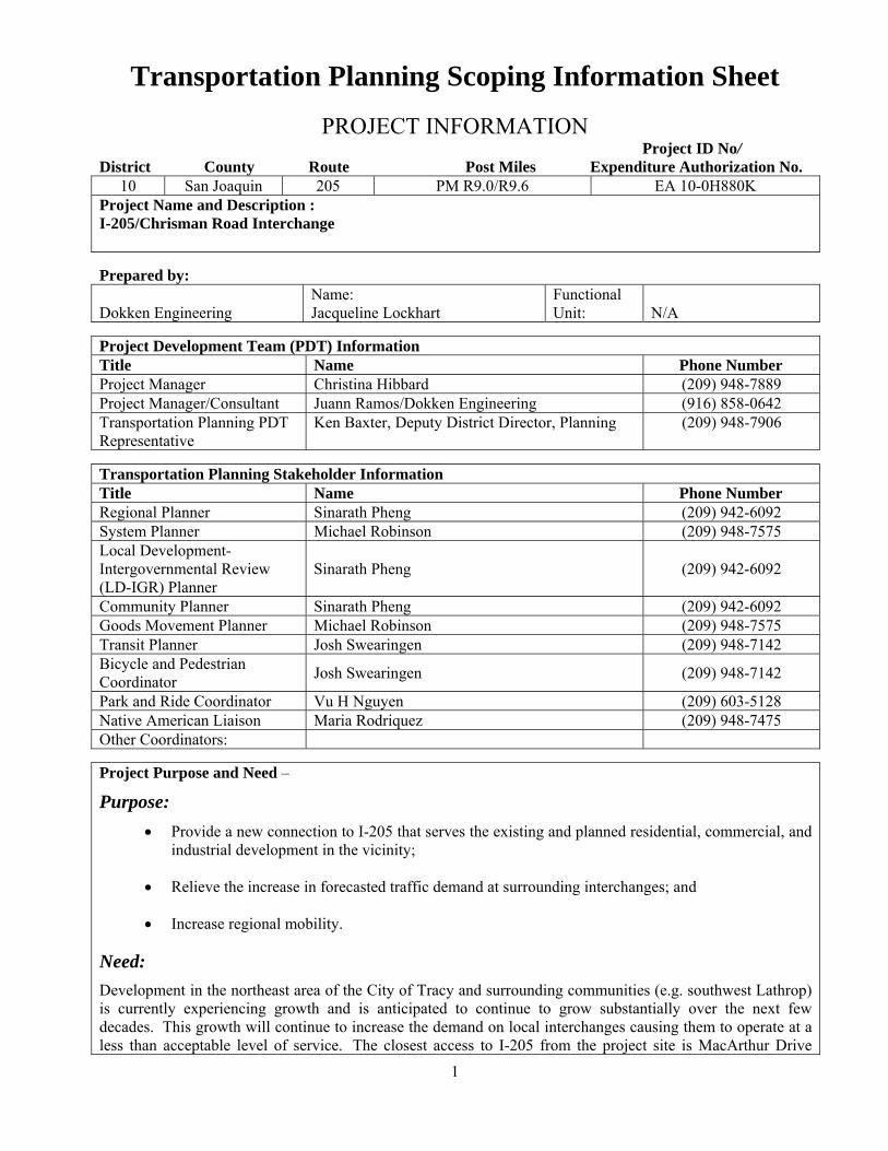
Transportation Planning Scoping Information Sheet
PROJECT INFORMATION Project ID No/ District County Route Post Miles Expenditure Authorization No.
10 San Joaquin 205 PM R9.0/R9.6 EA 10-0H880K Project Name and Description : I-205/Chrisman Road Interchange
Prepared by: Dokken Engineering
Name: Jacqueline Lockhart
Functional Unit:
N/A
Project Development Team (PDT) InformationTitle Name Phone Number Project Manager Christina Hibbard (209) 948-7889 Project Manager/Consultant Juann Ramos/Dokken Engineering (916) 858-0642 Transportation Planning PDT Representative
Ken Baxter, Deputy District Director, Planning (209) 948-7906
Transportation Planning Stakeholder Information Title Name Phone Number Regional Planner Sinarath Pheng (209) 942-6092 System Planner Michael Robinson (209) 948-7575 Local Development-Intergovernmental Review (LD-IGR) Planner
Sinarath Pheng (209) 942-6092
Community Planner Sinarath Pheng (209) 942-6092 Goods Movement Planner Michael Robinson (209) 948-7575 Transit Planner Josh Swearingen (209) 948-7142 Bicycle and Pedestrian Coordinator
Josh Swearingen (209) 948-7142
Park and Ride Coordinator Vu H Nguyen (209) 603-5128 Native American Liaison Maria Rodriquez (209) 948-7475 Other Coordinators:
Project Purpose and Need –
Purpose:
Provide a new connection to I-205 that serves the existing and planned residential, commercial, and industrial development in the vicinity;
Relieve the increase in forecasted traffic demand at surrounding interchanges; and
Increase regional mobility.
Need:
Development in the northeast area of the City of Tracy and surrounding communities (e.g. southwest Lathrop) is currently experiencing growth and is anticipated to continue to grow substantially over the next few decades. This growth will continue to increase the demand on local interchanges causing them to operate at a less than acceptable level of service. The closest access to I-205 from the project site is MacArthur Drive
2
where the future traffic demands at the interchange will result in an unacceptable Level of Service (LOS) F. To meet future traffic demands, the City of Tracy’s circulation element and the City of Lathrop’s General Plan identifies the need for a new interchange to be located between the MacArthur Drive interchange and the I-5 interchange.
1. Project Funding:
a
List all known and potential funding sources and percent splits: (ie. State Transportation Improvement Program (STIP)/State Highway Operations and Protection Program (SHOPP)/Transportation Enhancement (TE)/Environmental Enhancement and Mitigation (EEM)/Safe Routes to School (SR2S)/etc.). PA&ED – 20% Local, 80% Federal Demonstration Program
b Is this a measure project? Yes_√_/No__. If yes, name and describe the measure. Measure K – The measure is a ½ cent sales tax dedicated to transportation projects in San Joaquin County.
2. Regional Planning:
a Name of and contact information for Metropolitan Planning Organization (MPO) or Regional Transportation Planning Agency (RTPA). San Joaquin Council of Governments; (209) 235-0600
b Name of and contact information for local jurisdiction (City or County)
Zabih Zaca, City of Tracy
c
Provide the page number and project description as identified in the Regional Transportation Plan (RTP) and the date of adoption, or provide an explanation if not in RTP. 2011 RTP (Table 7-2): I-205 at Paradise Road/Chrisman Phase 1: Construct new interchange east-west ramps Phase 2: Construct new cloverleaf interchange
d
Provide nexus between the RTP objectives and the project to establish the basis for the project purpose and need. A new interchange on I-205 will meet the RTP Objectives to: Improve roadway access to key strategic economic centers; Improve regional roadway system performance
e Is the project located in an area susceptible to sea-level rise? No
f Name of Air Quality Management District (AQMD) San Joaquin Valley Air Pollution Control District
g
If the project is located in a federal non-attainment or attainment-maintenance area is the project: Regionally Significant? (per 40 (Code of Federal Regulations (CFR) 93.101) Y_√_/N__ Exempt from conformity? (per 40 CFR 93.126 and 93.128) Y__/N_√_ Exempt from regional analysis? (per 40 CFR 93.127) Y__/N_√_ Not exempt from conformity (must meet all requirements)? Y /N_√_
3. Native American Consultation and Coordination:
a If project is within or near an Indian Reservation or Rancheria? If so, provide the name of Tribe. No
b Has/have the Tribal Government(s) been consulted? Y___/N_√_. If no, why not? Not applicable
c
If the project requires Caltrans to use right-of-way on trust or allotted lands, this information needs to be included as soon as possible as a key topic in the consultation with the Tribe(s). Has the Tribe been consulted on this topic? Y___/N_√_. If no, why not? Not applicable
d Has the Bureau of Indian Affairs (BIA) been notified? Y__/N_√_ Not applicable
3
e Have all applicable Tribal laws, ordinances and regulations [Tribal Employment Rights Ordinances (TERO), etc.] been reviewed for required contract language and coordination? Not applicable
f If the Tribe has a TERO, is there a related Memorandum of Understanding between the District and the Tribe? Not applicable
g
Has the area surrounding the project been checked for prehistoric, archeological, cultural, spiritual, or ceremonial sites, or areas of potentially high sensitivity? If such areas exist, has the Tribe, Native American Heritage Commission or other applicable persons or entities been consulted? To be investigated during PA/ED as part of the technical studies for the environmental document.
h If a Native American monitor is required for this project, will this cost be reflected in cost estimates? Yes
i In the event of project redesign, will the changes impact a Native American community as described above in d, e, or h? No
4. System Planning:
a Is the project consistent with the DSMP? Y_√_/N__. If yes document approval date. If no, explain. September 2010
b Is the project identified in the TSDP? Y_√_/N__? If yes, document approval date: September 2010. If no, explain.
c
Is the project identified in the TCR/RCR or CSMP? Y_√_/N__. If yes, document approval date CSMP, May 2010__. If no, explain. Is the project consistent with the future route concept? Y_√_/N__. If no, explain.
d Provide the Concept Level of Service (LOS) through project area.
I-205 LOS=C
e Provide the Concept Facility – include the number of lanes. Does the Concept Facility include High Occupancy Vehicle lanes? Y_√_/N__. 8-lane, mixed flow plus 2 HOV
f Provide the Ultimate Transportation Corridor (UTC) – include the number of lanes. Does the UTC include High Occupancy Vehicle Lanes? Y√__/N__. 10 lane, mixed flow plus 2 HOV
g Describe the physical characteristics of the corridor through the project area (i.e. flat, rolling or mountainous terrain...). Flat
h Is the highway in an urban or rural area? Urban__/Rural_√_. Provide Functional Classification. 1-205 is a Principle Arterial Interstate Freeway
i Is facility a freeway, expressway or conventional highway? I-205 is a freeway, Chrisman Road is classified as an expressway per the City of Tracy Transportation Master Plan
j
Provide Route Designations: (i.e. Interregional Transportation Strategic Plan (ITSP) High Emphasis or Focus Route, Surface Transportation Assistance Act (STAA) Route, Scenic Route…). I-205 is part of the Freeway and Expressway System, the National Highway System, the Strategic Highway Corridor Network of National Defense (STRAHNET), the Federal Surface Transportation Assistance Act (STAA) National Truck Network for oversized trucks, and is classified as a “High Emphasis” and “Gateway” route in the Interregional Road System (IRRS).
k Describe the land uses adjacent to project limits (i.e. agricultural, industrial…).
Existing land uses are agricultural and industrial/commercial. The area is zoned industrial per the City of Tracy General Plan.
l Describe any park and ride facility needs identified in the TCR/CSMP, local plans, and RTP.
4
There is an existing park and ride facility at I-205/MacArthur Drive. No new facilities are identified for the project area.
m
Describe the Forecasted 10 and 20-year Vehicle Miles Traveled (VMT), Annual Average Daily Traffic (AADT), and Peak Hour truck data in the TCR. Include the source and year of Forecast, and names and types of traffic and travel demand analysis tools used. Per the I-205/I-5 CMSP (May 2010): The SJCOG countywide model was used and operational analysis of the roadway network was developed using CORSIM (Version 6) and Synchro 6 software. AADT: Year 2014=133,000, Year 2024=162,000
n Has analysis on Daily Vehicle Hours of Delay (DVHD) from the Highway Congestion Monitoring Program (HICOMP) been completed and included? Y__/N_√_.
5. Local Development – Intergovernmental Review (LD-IGR ):
List LD-IGR projects that may directly or indirectly impact the proposed Caltrans project or that the proposed Caltrans project may impact. (Attach additional project information if needed.)
LD-IGR Project Information Project
a County-Route-Postmile & Distance to Development.
N/A
b Development name, type, and size. N/A
c Local agency and/or private sponsor, and contact information.
N/A
d California Environmental Quality Act (CEQA) status and Implementation Date.
N/A
e If project includes federal funding, National Environmental Policy Act (NEPA) status.
N/A
f
All vehicular and non-vehicular unmitigated impacts and planned mitigation measures including Transportation Demand Management (TDM) and Transportation System Management (TSM) that would affect Caltrans facilities.
N/A
g Approved mitigation measures and implementing party.
N/A
h Value of constructed mitigation and/or amount of funds provided.
N/A
i
Encroachment Permit, Transportation Permit, Traffic Management Plan, or California Transportation Commission (CTC) Access approvals needed.
N/A
j Describe relationship to Regional Blueprint, General Plans, or County Congestion Management Plans.
N/A
k Inclusion in a Regional Transportation Plan Sustainable Community Strategy or Alternative Planning Strategy?
N/A
l Regional or local mitigation fee program in place?
N/A
6. Community Planning: INITIAL PID INFORMATION
a Has lead agency staff worked with any neighborhood/community groups in the area of the proposed
5
improvements? Y__/N__. If yes, summarize the process and its results including any commitments made to the community. If no, why not?
b
Are any active/completed/proposed Environmental Justice (EJ) or Community-Based Transportation (CBTP) Planning Grants in the project area? Y__/N_√_. If yes, summarize the project, its location, and whether/how it may interact with the proposed project.
c
Describe any community participation plans for this PID including how recommendations will be incorporated and/or addressed. Has a context sensitive solutions (CSS) approach been applied? Y_/N_√_ During PA/ED, the environmental document will be circulated for public comment. Context sensitive solutions (aesthetic themes, bike/ped improvements) will be incorporated into the project.
FINAL PID INFORMATION
d
How will the proposed transportation improvements impact the local community? Is the project likely to create or exacerbate existing environmental or other issues, including public health and safety, air quality, water quality, noise, environmental justice or social equity? Y__/N__. Describe issues, concerns, and recommendations (from sources including neighborhood/community groups) and what measures will be taken to reduce existing or potential negative effects. This will be determined during PA/ED as part of the environmental process
e Does this highway serve as a main street? Y__/N_√_. If yes, what main street functions and features need to be protected or preserved?
7. Freight Planning:
INITIAL PID INFORMATION
a Identify all modal and intermodal facilities that may affect or be affected by the project.
I-205, I-5
FINAL PID INFORMATION
b
Describe how the design of this project could facilitate or impede Goods Movement and relieve choke points both locally and statewide through grade separations, lane separations, or other measures (e.g., special features to accommodate truck traffic and at-grade railroad crossings). Providing a new access point to Interstate 205 will aid in the distribution of truck traffic at nearby interchanges as well as provide a more direct access point to an industrial area that serves as a destination for truck traffic.
c
Describe how the project integrates and interconnects with other modes (rail, maritime, air, etc.). Do possibilities exist for an intermodal facility or other features to improve long-distance hauling, farm-to-market transportation and/or accessibility between warehouses, storage facilities, and terminals? No other modes of operation beyond truck related freight movement exist within the project area.
d
Is the project located in a high priority goods movement area, included in the Goods Movement Action Plan (GMAP) or on a Global Gateways Development Program (GGDP) route? Y_√_/N__. If yes, describe. The Caltrans 2001 Global Gateways Development Program (GGDP) Report identified I-205 among the top priority global gateways in California due to its part in the vital network of goods movement.
e
Is the project on a current and/or projected high truck volume route [e.g., Average Annual Daily Truck Traffic (AADTT) of 5 axle trucks is greater than 3000]? Yes_√_/N__. If yes, describe how the project addresses this demand. Per the I-205/I-5 CSMP the Truck AADT is greater than 11,000. The project will improve freight access to an industrial area that serves as a designation for truck traffic.
f If the project is located near an airport, seaport, or railroad depot, describe how circulation (including truck parking) needs are addressed. N/A
g Describe any other freight issues.
6
N/A
8. Transit (bus, light rail, commuter rail, intercity rail, high speed rail): INITIAL PID INFORMATION a List all local transit providers that operate within the corridor.
Tracer Transit (City of Tracy), San Joaquin Regional Transit District (SJRTD)
b Have transit agencies been contacted for possible project coordination? Y__/N_√_. If no, why not? To be performed during PA&ED.
c Describe existing transit services and transit features (bus stops, train crossings, and transit lines) within the corridor. SJRTD currently utilizes Grant Line Road as a route for two of its bus routes. There is an existing bus stop for SJRTD and Tracer Transit at the park and ride facility at I-205/MacArthur Drive.
d Describe transit facility needs identified in short- and long-range transit plans and RTP. Describe how these future plans affect the corridor. To be performed during PA&ED.
FINAL PID INFORMATION
e
Describe how the proposed project integrates transit and addresses impacts to transit services and transit facilities. No new transit facilities are anticipated. Impacts to transit during construction will be addressed as part of Final Design.
f Have transit alternatives and improvement features been considered in this project? Y__/N_√_ If yes, describe. If no, why not? No new transit facilities are anticipated.
9. Bicycle: INITIAL PID INFORMATION
a Does the facility provide for bicyclist safety and mobility needs? If no, please explain. Yes
b Are any improvements for bicyclist safety and mobility proposed for this facility by any local agencies or included in bicycle master plans? If yes, describe (including location, time frame, funding, etc.). City of Tracy Bikeways Master Plan
c Are there any external bicycle advocacy groups and bicycle advisory committees that should be included in the project stakeholder list? If so, provide contact information.
FINAL PID INFORMATION
d Will bicycle travel deficiencies be corrected? How or why not? Yes, standard facilities will be incorporated.
e How will this project affect local agency plans for bicycle safety and mobility improvements? No impact
f
If the project is the construction of a new freeway or modification to an existing freeway, will it sever or destroy existing provisions for bicycle travel? If yes, describe how bicycle travel provisions will be included in this project. No
10. Pedestrian including Americans with Disabilities Act (ADA): INITIAL PID INFORMATION
a
Does this facility provide for pedestrian safety and mobility needs? If so, describe pedestrian facilities. Do continuous and well-maintained sidewalks exist? Are pedestrians forced to walk in the roadway at any locations due to lack of adequate pedestrian facilities? Please explain. Yes. Sidewalks, curb ramps and crosswalks will be provided throughout the project.
b Are pedestrian crossings located at reasonable intervals? Yes. Crossings will be provided at intersections
7
c Are all pedestrian facilities within the corridor ADA accessible and in compliance with Federal and State ADA laws and regulations? Yes
FINAL PID INFORMATION
d Will pedestrian travel deficiencies be corrected? How or why not? Yes, standard facilities will be incorporated.
e How will this project affect local agency plans for pedestrian safety and mobility improvements? No impact
f
If the project is the construction of a new freeway or modification to an existing freeway, will it sever or destroy existing provisions for pedestrian travel? If yes, describe how pedestrian travel provisions will be included in this project. No
g Are there any external pedestrian advocacy groups and advisory committees that should be included in the project stakeholder list? If so, provide contact information.
h
Have ADA barriers as noted in the District’s ADA Transition Plan been identified within the project limits? If not included in the project, provide justification and indicate whether District Design coordinator approval was obtained.
No ADA barriers have been identified per the District 10 ADA Transition Plan.
11. Equestrian: INITIAL PID INFORMATION
a If this corridor accommodates equestrian traffic, describe any project features that are being considered to improve safety for equestrian and vehicular traffic? Accommodations for equestrian traffic are not needed for this project.
FINAL PID INFORMATION
b Have features that accommodate equestrian traffic been identified? If so, are they included a part of this project? Describe. If no, why not? Accommodations for equestrian traffic are not needed for this project.
12. Intelligent Transportation Systems (ITS): INITIAL PID INFORMATION
a
Have ITS features such as closed-circuit television cameras, signal timing, multi-jurisdictional or multimodal system coordination been considered in the project? Y__/N_√_. If yes, describe. If no, explain. ITS features will be considered during PA/ED and Final Design.
FINAL PID INFORMATION
b Have ITS features been identified? If so, are they included a part of this project? Describe. If no, why not? ITS features will be considered during PA/ED and Final Design.
ATTACHMENT C
Plan View Exhibits For Alternatives 1 & 2

ATTACHMENT D
Typical Cross Sections For Alternative 2
ATTACHMENT E
Cost Estimates For Alternative 2
1
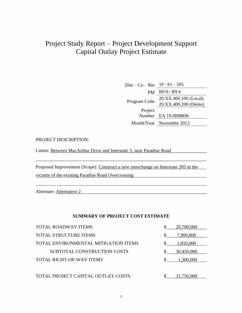
Project Study Report – Project Development Support
Capital Outlay Project Estimate
Dist – Co – Rte 10 –SJ – 205
PM R9.0 / R9.6
Program Code 20.XX.400.100 (Local)
20.XX.400.200 (Demo)
Project
Number EA 10-0H880K
Month/Year November 2012
PROJECT DESCRIPTION:
Limits: Between MacArthur Drive and Interstate 5, near Paradise Road
Proposed Improvement (Scope): Construct a new interchange on Interstate 205 in the
vicinity of the existing Paradise Road Overcrossing
Alternate: Alternative 2
SUMMARY OF PROJECT COST ESTIMATE
TOTAL ROADWAY ITEMS $ 20,700,000
TOTAL STRUCTURE ITEMS $ 7,900,000
TOTAL ENVIRONMENTAL MITIGATION ITEMS $ 1,850,000
SUBTOTAL CONSTRUCTION COSTS $ 30,450,000
TOTAL RIGHT-OF-WAY ITEMS $ 1,300,000
TOTAL PROJECT CAPITAL OUTLAY COSTS $ 31,750,000
2
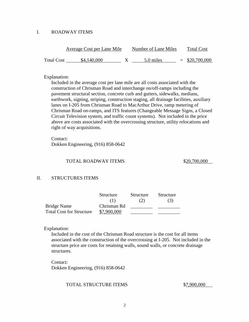
I. ROADWAY ITEMS
Average Cost per Lane Mile Number of Lane Miles Total Cost
Total Cost $4,140,000 X 5.0 miles = $20,700,000
Explanation:
Included in the average cost per lane mile are all costs associated with the
construction of Chrisman Road and interchange on/off-ramps including the
pavement structural section, concrete curb and gutters, sidewalks, medians,
earthwork, signing, striping, construction staging, all drainage facilities, auxiliary
lanes on I-205 from Chrisman Road to MacArthur Drive, ramp metering of
Chrisman Road on-ramps, and ITS features (Changeable Message Signs, a Closed
Circuit Television system, and traffic count systems). Not included in the price
above are costs associated with the overcrossing structure, utility relocations and
right of way acquisitions.
Contact:
Dokken Engineering, (916) 858-0642
TOTAL ROADWAY ITEMS $20,700,000
II. STRUCTURES ITEMS
Structure
(1)
Structure
(2)
Structure
(3)
Bridge Name Chrisman Rd _________ _________
Total Cost for Structure $7,900,000 _________ _________
Explanation:
Included in the cost of the Chrisman Road structure is the cost for all items
associated with the construction of the overcrossing at I-205. Not included in the
structure price are costs for retaining walls, sound walls, or concrete drainage
structures.
Contact:
Dokken Engineering, (916) 858-0642
TOTAL STRUCTURE ITEMS $7,900,000
3
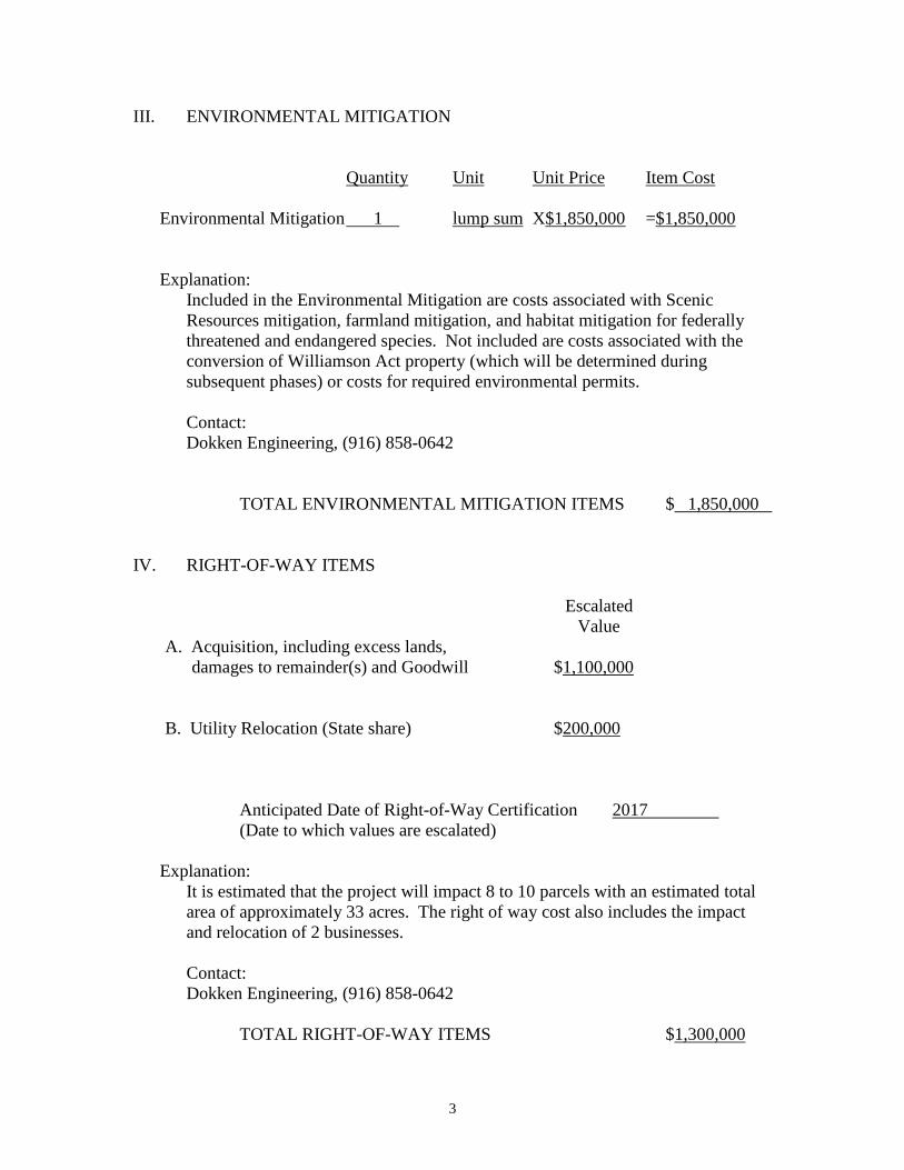
III. ENVIRONMENTAL MITIGATION
Quantity Unit Unit Price Item Cost
Environmental Mitigation 1 lump sum X$1,850,000 =$1,850,000
Explanation:
Included in the Environmental Mitigation are costs associated with Scenic
Resources mitigation, farmland mitigation, and habitat mitigation for federally
threatened and endangered species. Not included are costs associated with the
conversion of Williamson Act property (which will be determined during
subsequent phases) or costs for required environmental permits.
Contact:
Dokken Engineering, (916) 858-0642
TOTAL ENVIRONMENTAL MITIGATION ITEMS $ 1,850,000
IV. RIGHT-OF-WAY ITEMS
Escalated
Value
A. Acquisition, including excess lands,
damages to remainder(s) and Goodwill
$1,100,000
B. Utility Relocation (State share) $200,000
Anticipated Date of Right-of-Way Certification 2017
(Date to which values are escalated)
Explanation:
It is estimated that the project will impact 8 to 10 parcels with an estimated total
area of approximately 33 acres. The right of way cost also includes the impact
and relocation of 2 businesses.
Contact:
Dokken Engineering, (916) 858-0642
TOTAL RIGHT-OF-WAY ITEMS $1,300,000

ATTACHMENT F
Conceptual Cost Estimate – Right Of Way Component
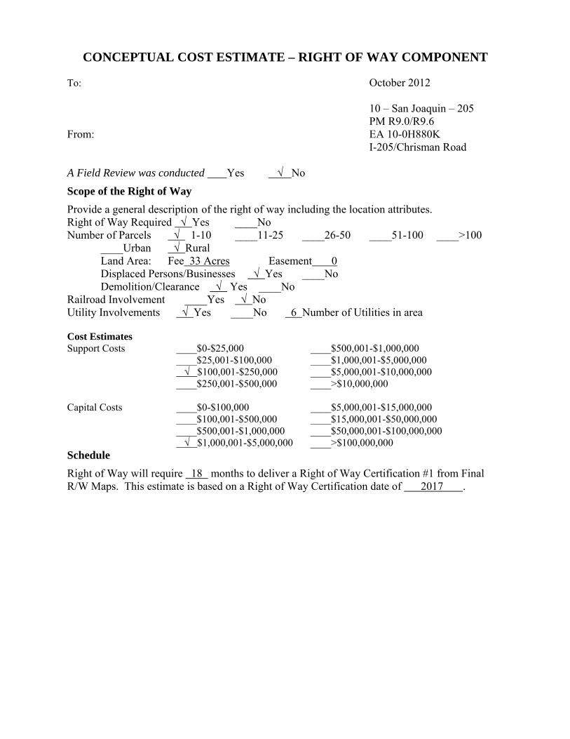
CONCEPTUAL COST ESTIMATE – RIGHT OF WAY COMPONENT
To: October 2012 10 – San Joaquin – 205 PM R9.0/R9.6 From: EA 10-0H880K
I-205/Chrisman Road
A Field Review was conducted Yes √ No
Scope of the Right of Way
Provide a general description of the right of way including the location attributes. Right of Way Required √ Yes ____No Number of Parcels √ 1-10 ____11-25 ____26-50 ____51-100 ____>100 ____Urban √ Rural Land Area: Fee 33 Acres Easement 0 Displaced Persons/Businesses √ Yes ____No Demolition/Clearance √ Yes ____No Railroad Involvement ____Yes √ No Utility Involvements √ Yes ____No 6 Number of Utilities in area Cost Estimates Support Costs ____$0-$25,000 ____$500,001-$1,000,000 ____$25,001-$100,000 ____$1,000,001-$5,000,000 √ $100,001-$250,000 ____$5,000,001-$10,000,000 ____$250,001-$500,000 ____>$10,000,000 Capital Costs ____$0-$100,000 ____$5,000,001-$15,000,000 ____$100,001-$500,000 ____$15,000,001-$50,000,000 ____$500,001-$1,000,000 ____$50,000,001-$100,000,000 √ $1,000,001-$5,000,000 ____>$100,000,000 Schedule
Right of Way will require 18 months to deliver a Right of Way Certification #1 from Final R/W Maps. This estimate is based on a Right of Way Certification date of 2017 .
ATTACHMENT G
Preliminary Environmental Analysis Report (PEAR)
September 2012
1 of 13
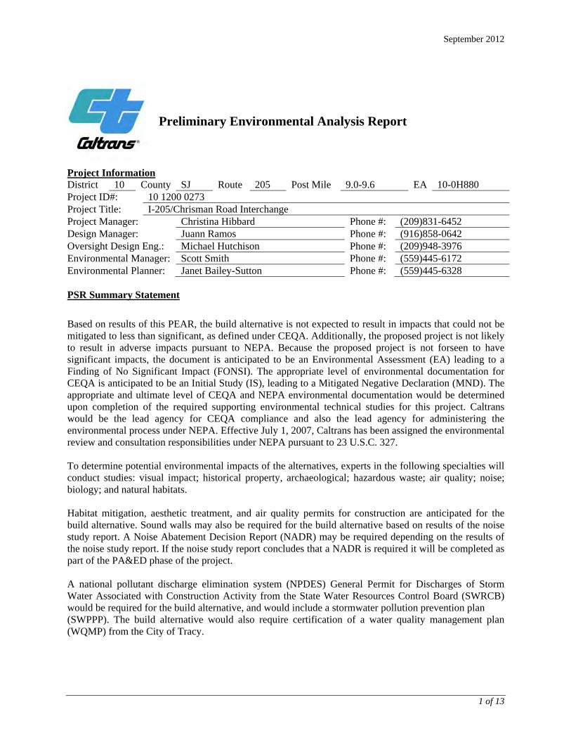
Preliminary Environmental Analysis Report
Project Information District 10 County SJ Route 205 Post Mile 9.0-9.6 EA 10-0H880 Project ID#: 10 1200 0273 Project Title: I-205/Chrisman Road Interchange Project Manager: Christina Hibbard Phone #: (209)831-6452 Design Manager: Juann Ramos Phone #: (916)858-0642 Oversight Design Eng.: Michael Hutchison Phone #: (209)948-3976 Environmental Manager: Scott Smith Phone #: (559)445-6172 Environmental Planner: Janet Bailey-Sutton Phone #: (559)445-6328 PSR Summary Statement
Based on results of this PEAR, the build alternative is not expected to result in impacts that could not be mitigated to less than significant, as defined under CEQA. Additionally, the proposed project is not likely to result in adverse impacts pursuant to NEPA. Because the proposed project is not forseen to have significant impacts, the document is anticipated to be an Environmental Assessment (EA) leading to a Finding of No Significant Impact (FONSI). The appropriate level of environmental documentation for CEQA is anticipated to be an Initial Study (IS), leading to a Mitigated Negative Declaration (MND). The appropriate and ultimate level of CEQA and NEPA environmental documentation would be determined upon completion of the required supporting environmental technical studies for this project. Caltrans would be the lead agency for CEQA compliance and also the lead agency for administering the environmental process under NEPA. Effective July 1, 2007, Caltrans has been assigned the environmental review and consultation responsibilities under NEPA pursuant to 23 U.S.C. 327. To determine potential environmental impacts of the alternatives, experts in the following specialties will conduct studies: visual impact; historical property, archaeological; hazardous waste; air quality; noise; biology; and natural habitats. Habitat mitigation, aesthetic treatment, and air quality permits for construction are anticipated for the build alternative. Sound walls may also be required for the build alternative based on results of the noise study report. A Noise Abatement Decision Report (NADR) may be required depending on the results of the noise study report. If the noise study report concludes that a NADR is required it will be completed as part of the PA&ED phase of the project. A national pollutant discharge elimination system (NPDES) General Permit for Discharges of Storm Water Associated with Construction Activity from the State Water Resources Control Board (SWRCB) would be required for the build alternative, and would include a stormwater pollution prevention plan (SWPPP). The build alternative would also require certification of a water quality management plan (WQMP) from the City of Tracy.

September 2012
2 of 13
Project Description
The City of Tracy (City) proposes to construct a new interchange along I-205 between MacArthur Drive and I-5 situated at or near the existing Paradise Road overcrossing. The proposed project would serve the forecasted increase in traffic demand caused by land development in surrounding areas. The new interchange location must meet FHWA and Caltrans interchange spacing criteria along I-205 between MacArthur Drive and I-5.
Purpose and Need
Purpose The purpose of the project is to:
Provide a new connection to I-205 that serves the existing and planned residential, commercial and industrial development in the vicinity;
Relieve the forecasted increase in traffic demand at surrounding interchanges; and
Increase regional mobility.
Need The northeast area of Tracy and its surrounding communities (particularly southwest Lathrop) are currently growing and developing. This is expected to continue and increase over the next few decades. This growth will continue to increase the demand on local interchanges causing them to operate at a less than acceptable level of service (LOS). The closest access to I-205 from the project site is MacArthur Drive where the future traffic demands at the interchange will result in an unacceptable LOS F. To meet future traffic demands, the City of Tracy’s circulation element and the City of Lathrop’s General Plan identify the need for a new interchange to be located on I-205 between the MacArthur Drive interchange and the I-5 interchange. The proposed location of the new interchange is located at or near the Paradise Road overcrossing, which is between the MacArthur Drive interchange and the I-5 interchange.
Description of Work
The City of Tracy proposes to construct a new interchange along I-205 between MacArthur Drive and I-5. The proposed project would serve the forecasted increase in traffic demand caused by land development in surrounding areas. The new interchange location must meet FHWA and Caltrans interchange spacing criteria along I-205 between MacArthur Drive and I-5. Alternatives
No Build Alternative: The No Build Alternative would not add a new access point to I-205 near the existing Paradise Road overcrossing. The existing Paradise Road overcrossing would not be widened to accommodate any future widening of I-205. Build Alternative: The build alternative proposes to construct a new interchange between MacArthur Dive and I-5 at the approximate location of the existing Paradise Road overcrossing. The proposed interchange configuration will be a partial cloverleaf (Type L-9) which includes four diamond-type ramps and two loop on-ramps. The overcrossing structure will accommodate six traveled lanes, shoulders and sidewalks, and will accommodate the future widening of I-205 to a ten-lane ultimate facility. Each of the ramp intersections
September 2012
3 of 13
will be signalized. The interchange will tie into the existing Paradise Road on both the north and south sides of the interstate. As part of a future project, the City of Tracy will extend Chrisman Road at Grant Line Road north to connect to the project. New local intersections for Pescadero Road and Paradise Road will be constructed on the Chrisman Road extension. A benefit to the proposed Type L-9 interchange configuration is the ability to phase the construction as the traffic demand requires additional capacity and as funding becomes available. The initial interchange can be built with only the four east-west diamond-type on- and off-ramps in their ultimate location, and the interior loop on-ramps can be constructed in a second phase. Ultimate right-of-way would be acquired with the first phase for the construction of the diamond ramps. This phasing strategy is consistent with the SJCOG 2011 RTP for the I-205 at Paradise Road/Chrisman Road interchange with the initial Phase 1 construction being a Tier I project (highest priority) and Phase 2 being a Tier II project (additional regionally important project but which is not able to be funded at the current time). Based on a preliminary traffic analysis performed for the Chrisman Road Precise Plan, the intersections for the I-205/Chrisman Road interchange will operate at an acceptable level of service (LOS) for cumulative traffic volumes representing 2025 conditions for both a Phase 1 construction and the ultimate build out for Phase 2 of the interchange. Both intersections are projected to operate at an LOS B or better with little delay during the peak hour.
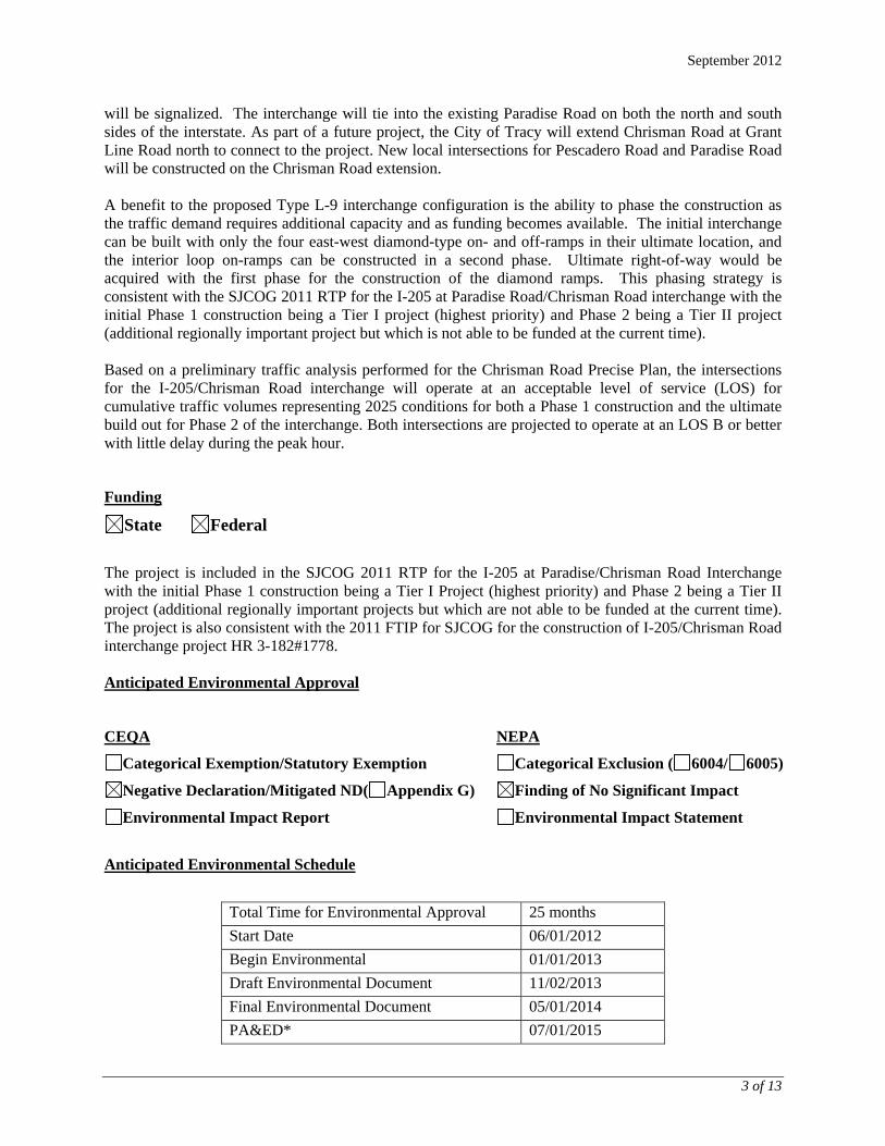
Funding
State Federal
The project is included in the SJCOG 2011 RTP for the I-205 at Paradise/Chrisman Road Interchange with the initial Phase 1 construction being a Tier I Project (highest priority) and Phase 2 being a Tier II project (additional regionally important projects but which are not able to be funded at the current time). The project is also consistent with the 2011 FTIP for SJCOG for the construction of I-205/Chrisman Road interchange project HR 3-182#1778. Anticipated Environmental Approval
CEQA NEPA
Categorical Exemption/Statutory Exemption Categorical Exclusion ( 6004/ 6005)
Negative Declaration/Mitigated ND( Appendix G) Finding of No Significant Impact
Environmental Impact Report Environmental Impact Statement
Anticipated Environmental Schedule
Total Time for Environmental Approval 25 months
Start Date 06/01/2012
Begin Environmental 01/01/2013
Draft Environmental Document 11/02/2013
Final Environmental Document 05/01/2014
PA&ED* 07/01/2015
September 2012
4 of 13
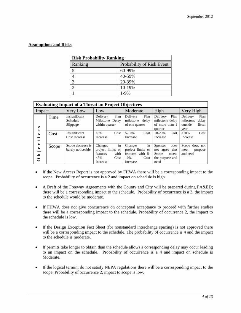
Assumptions and Risks
Risk Probability Ranking Ranking Probability of Risk Event 5 60-99% 4 40-59% 3 20-39% 2 10-19% 1 1-9%
Evaluating Impact of a Threat on Project Objectives Impact Very Low Low Moderate High Very High
Ob
je
ct
iv
es
Time Insignificant Schedule Slippage
Delivery Plan Milestone Delay within quarter
Delivery Plan milestone delay of one quarter
Delivery Plan milestone delay of more than 1 quarter
Delivery Plan milestone delay outside fiscal year
Cost Insignificant Cost Increase
<5% Cost Increase
5-10% Cost Increase
10-20% Cost Increase
>20% Cost Increase
Scope Scope decrease is barely noticeable
Changes in project limits or features with <5% Cost Increase
Changes in project limits or features with 5-10% Cost Increase
Sponsor does not agree that Scope meets the purpose and need
Scope does not meet purpose and need
If the New Access Report is not approved by FHWA there will be a corresponding impact to the
scope. Probability of occurrence is a 2 and impact on schedule is high.
A Draft of the Freeway Agreements with the County and City will be prepared during PA&ED; there will be a corresponding impact to the schedule. Probability of occurrence is a 3, the impact to the schedule would be moderate.
If FHWA does not give concurrence on conceptual acceptance to proceed with further studies there will be a corresponding impact to the schedule. Probability of occurrence 2, the impact to the schedule is low.
If the Design Exception Fact Sheet (for nonstandard interchange spacing) is not approved there will be a corresponding impact to the schedule. The probability of occurrence is 4 and the impact to the schedule is moderate.
If permits take longer to obtain than the schedule allows a corresponding delay may occur leading to an impact on the schedule. Probability of occurrence is a 4 and impact on schedule is Moderate.
If the logical termini do not satisfy NEPA regulations there will be a corresponding impact to the scope. Probability of occurrence 2, impact to scope is low.

September 2012
5 of 13
If independent utility is not provided there will be a corresponding impact to the scope. Probability of occurrence is 1, impact is very low.
If stage construction requires closure of I-205 for falsework erection and demolition of the existing bridge. A potential detour and staging of ramps may also be required. Probability of occurrence 2, impact to scope is low.
Mitigation
No environmental commitment measures are applicable to the no-build alternative. The following environmental commitment measures are pertinent to the build alternative, and are based on the environmental setting and typical requirements to minimize project-related impacts for similar transportation projects:
Right of Way Capital (050)
California Department of Fish and Game 1602 permit fee: $4,482.75 (2012 dollars). California Regional Water Quality Control Board 401 permit fee: $1,000 (2012 dollars). United States Army Corps of Engineers 404 permit Scenic resources – Aesthetic treatment above and beyond interchange landscaping treatments
to augment standard landscaping budget to negate any negative impact of the new element on the farmland scenery is estimated to cost $200,000 (2012 dollars).
Williamson Act – (TBD)
Costs are estimated and would likely change as project information becomes available.
Construction Capital (042)
Biological resources – Cost estimates should include potential habitat mitigation for the
federally threatened and endangered species listed in the biological discussion as well as any potential biological features determined to be jurisdictional. This is estimated to cost $150,000 (2012 dollars).
Costs values displayed are estimated and would likely change as project information becomes available.
Disclaimer
This report is not an environmental document. Preliminary analysis, determinations, and estimates of mitigation costs are based on the project description provided in this report. The estimates and conclusions provided are approximate and are based on cursory analysis of probable effects. This report is to provide a preliminary level of environmental analysis to supplement the project initiation document. Changes in project scope, alternatives, or environmental laws will require a reevaluation of this report. Review and Approval
I confirm that environmental cost, scope, and schedule have been satisfactorily completed and that the PEAR meets all Caltrans requirements. Also, if the project is scoped as a routine EA, complex EA, or EIS, I verify that the HQ DEA Coordinator has concurred in the Class of Action.
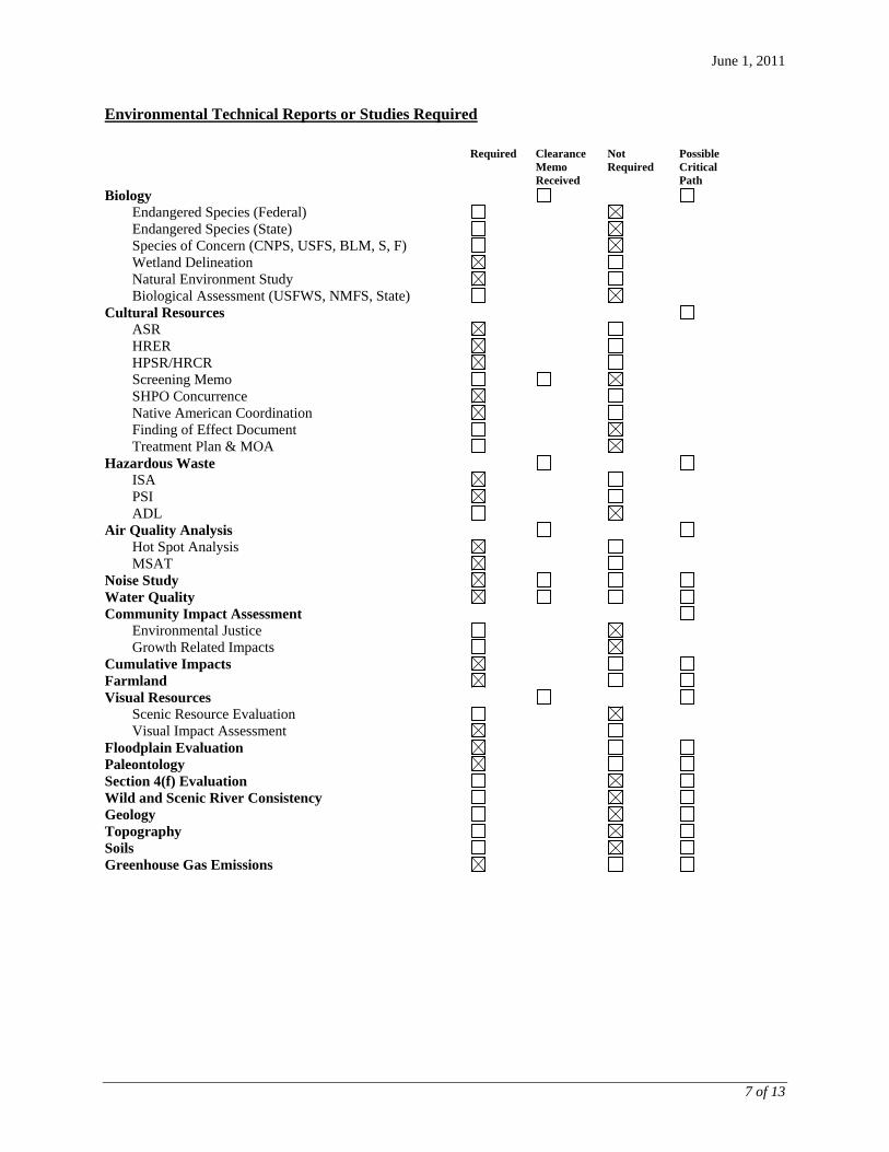
June 1, 2011
7 of 13
Environmental Technical Reports or Studies Required
Required Clearance
Memo Received
Not Required
Possible Critical Path
Biology
Endangered Species (Federal) Endangered Species (State) Species of Concern (CNPS, USFS, BLM, S, F) Wetland Delineation Natural Environment Study Biological Assessment (USFWS, NMFS, State) Cultural Resources ASR HRER HPSR/HRCR Screening Memo SHPO Concurrence Native American Coordination Finding of Effect Document Treatment Plan & MOA Hazardous Waste ISA PSI ADL Air Quality Analysis Hot Spot Analysis MSAT Noise Study Water Quality Community Impact Assessment Environmental Justice Growth Related Impacts Cumulative Impacts Farmland Visual Resources Scenic Resource Evaluation Visual Impact Assessment Floodplain Evaluation Paleontology Section 4(f) Evaluation Wild and Scenic River Consistency Geology Topography Soils Greenhouse Gas Emissions
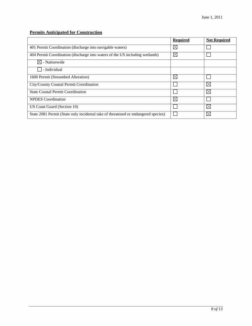
June 1, 2011
8 of 13
Permits Anticipated for Construction
Required Not Required
401 Permit Coordination (discharge into navigable waters)
404 Permit Coordination (discharge into waters of the US including wetlands)
- Nationwide
- Individual
1600 Permit (Streambed Alteration)
City/County Coastal Permit Coordination
State Coastal Permit Coordination
NPDES Coordination
US Coast Guard (Section 10)
State 2081 Permit (State only incidental take of threatened or endangered species)
June 1, 2011
9 of 13
Discussion of Technical Review
Preliminary analyses of resources are below. Biology A natural environment study (NES) will be prepared to evaluate the projects potential to adversely affect protected species. Minimization measures will be identified to avoid adversely affecting migratory birds. The adjacent farmlands use flooding irrigation methods, so it will be necessary to determine if these are “waters of the U.S.,” which will require a jurisdictional delineation to be included in the NES. The California Natural Diversity Database (CNNDB) indicates that the Union Island United States Geological Survey 7.5 minute quadrangle may contain habitat suitable for the federally threatened California red legged frog (Rana draytonii), California tiger salamander (Ambystoma californiense), giant garter snake (Thamnophis gigas), vernal pool fairy shrimp (Branchinecta lynchi), valley elderberry longhorn beetle (Desmocerus californicus dimorphus), and the federally endangered vernal pool tadpole shrimp (Lepidurus packardi), riparian brush rabbit (Sylvilagus bachmani riparius), large-flowered fiddleneck (Amsinckia grandiflora), and San Joaquin kit fox (Vulpes macrotis mutica). On August 27, 2012, Dokken Engineering biologist Sarah Holm observed that the project site primarily consists of hardscape and actively used farmland. The actively used farmland could be providing foraging habitat for the San Joaquin kit fox and hawks such as Swainson’s hawk. The northern most limit of the project is adjacent to (approximately 400 feet) the Tom Paine Slough. No direct impacts to this water body are anticipated; however, species could be using this water body and surrounding uplands as habitat. The slough is sparsely vegetated and no emergent vegetation was observed. As a result, the slough does not appear suitable for California red-legged frog or giant garter snake. In addition, no water or adjacent wetlands or vernal pools were observed that could provide adequate breeding habitat for California tiger salamander. No elderberry shrubs were observed and it is not anticipated that sensitive plant species will be identified during focused surveys. A clump of large Eucalyptus trees is present at the southeast limits of the project. These could provide nesting habitat for hawks and other migratory birds. Cultural Resources For the build alternative a Historic Property Survey Report (HPSR), Historic Resources Evaluation Report (HRER), and Archaeological Survey Report (ASR) are recommended for the proposed project. Identification of an area of potential effect, an archaeological survey, background research, and a new records search from California State University, Stanislaus, and Central California Information Center would be part of these technical studies. An HRER may be necessary due to residential structures as well as structures associated with agriculture within the project area. These structures may require evaluation for historic context. Dokken Engineering Archaeologist Namat Hosseinion conducted a pedestrian survey of the archaeological project area on January 9, 2012. Mr. Hosseinion holds an M.A. in Archaeology from California State University Sacramento and holds a B.A. degree in Anthropology from the University of California, San Diego. He has 12 years of archaeological experience in Cultural Resource Management throughout California and the Great Basin and meets the Caltrans Professionally Qualified Staff requirements for Co-Principal Investigator. The project area consisted of intensive farmland, some modern light commercial, modern industrial warehouses, and dairy farms. There are two homes in the project footprint that date to 1924 and 1936 that well potentially require evaluation. Based on initial site visits and distance the water resources there is a low likelihood of prehistoric or historic cultural resources to be present within the project area. The active
June 1, 2011
10 of 13
farming in the project area are anticipated to bring any potential materials to the surface that can be identified during phase I pedestrian surveys. A formal records search through Central California Information Center will be conducted as part of the PA&ED phase of the project. Also, for Section 106 compliance Native American consultation would be conducted, beginning with a request for sacred lands from the Native American Heritage Commission. Hazardous Waste An initial site assessment (ISA) would be prepared for the proposed project to evaluate whether any recorded or visible hazardous waste or hazards materials occur in the project area. If any hazards are found additional remediation efforts or testing may be necessary. The ISA will include a governmental records search, select agency interviews (if deemed necessary), aerial photography and topographic review, and visual site surveys. An ISA checklist was prepared for the proposed project and it was found that there are agricultural properties within the project vicinity that have the potential for pesticide/herbicide contaminants. There are also dairy operations within the project vicinity that have the potential to contain hazardous materials onsite. The ISA checklist showed that there is the potential for hazardous waste within the project area, therefore an ISA would need to be prepared as part of PA&ED (see attached ISA checklist). Air Quality Analysis The proposed project is located within the City of Tracy, which is located within the San Joaquin Valley Air Basin and under the jurisdiction of San Joaquin Valley Air Pollution Control District (SJVAPCD). The San Joaquin Valley Air Basin is designated as a non-attainment area for ozone and PM10. An Air Quality Report would be prepared for the proposed project and to comply with all Federal, State and local air quality laws and regulations. The Air Quality Report will include a qualitative analysis of potential impacts on carbon monoxide (CO) or particulate matter (PM10/PM2.5), following the 1997 CO Protocol by U.C. Davis and the FHWA’s PM2.5/PM10 qualitative analysis guidance (March 2006). A qualitative analysis of mobile source air toxics (MSAT) would also be included, following FHWA’s Interim Guidance Update on Mobile Source Air Toxic Analysis in NEPA (2009). The air quality report would also include: discussion of mitigation of fugitive dust (including PM10) according to the SJVAPCD. Rule 403 for fugitive dust; naturally occurring asbestos; and a quantitative analysis for greenhouse gases (GHG) using the EMFAC model for the no-build alternative and the build alternative. Construction-related emissions would be quantified using the urban emissions (URBEMIS) model. An air quality conformity analysis would also be necessary for this project. This phasing strategy is consistent with the San Joaquin Council of Governments (SJCOG) 2011 Regional Transportation Plan (RTP) for the I-205 at Paradise Road/Chrisman Road interchange with the initial Phase 1 construction being a Tier I project (highest priority) and Phase 2 being a Tier II project (additional regionally important projects but which are not able to be funded at the current time). The project is also consistent with the 2011 Federal Transportation Improvement Program (FTIP) for SJCOG for the construction of I-205/Chrisman Road interchange project HR 3-182 #1778. Interagency consultation (City of Tracy and SJCOG) will need to be carried out for the proposed project. Also, Caltrans will need to submit a conformity determination to FHWA for FHWA’s conformity determination. Noise Study The build alternative would be a Type I project, as defined in Caltrans Technical Noise Supplement, since a new interchange would be constructed. A Noise Study Report is required and would follow Caltrans’ Traffic Noise Analysis Protocol (CatNAP) and the Caltrans Technical Noise Supplement (TNS). Potentially sensitive receptors include farming properties adjacent to I-205 all approximately 1,000 to 2, 000 feet from areas of major change in the noise environment. Substantial noise impacts from the project are not anticipated.
June 1, 2011
11 of 13
Water Quality There are two water features north of the project area, north of Arbor Road and east of Paradise Avenue. The Natural Environment Study (NES) will include a jurisdictional wetland delineation. The project is within the San Joaquin Delta watershed, Hydroloic Unit Code #18040003 watershed. The build alternative would add impervious surface area, which would increase stormwater run-off from the interchange. Drainage improvements would be incorporated into the proposed design as necessary to control additional runoff, and as mentioned above, further investigation would be necessary to determine if the existing flood control channel is adequate for diverting the extra runoff. With the appropriate mitigation, any additional runoff created by the improvements is not expected to exceed the capacity of storm water drainage systems. Additional traffic lanes from the project would be a source of potential pollutants, especially suspended solids and petroleum hydrocarbons from increased stormwater runoff from the proposed roadway surface. Permanent design pollution prevention best management practices (BMPs), in compliance with Caltrans’ Statewide Stormwater Management Plan, would be required to treat additional runoff. The construction of the proposed project would operate under an NPDES General Permit with BMPs as required by the City of Tracy and the regional water quality control board to minimize water erosion of exposed soils and resultant sediment and surface contaminant loading into the storm drain system and downstream water bodies. As part of the NPDES General Permit, a SWPPP would be prepared. Consequently, the proposed project is not expected to violate any water quality or waste discharge standard, in this regard. Community Impact Assessment Since the project would require right-of-way acquisition for the build alternative, including dairy farm land, a community impact assessment would be necessary. Also, if there are relocations due to the proposed project, a relocation impact statement would also be necessary to evaluate the impacts of the relocations. Cumulative Impacts Based on review of the environmental resources above, it is anticipated that cumulative impacts would not be substantial for the build alternative. The project is included in pertinent planning documents, it would accommodate for planned growth. There is a moderate potential for other unidentified impacts; however these issues will be included in the cumulative impact section of the environmental document. Farmland Portions of the proposed build alternative are on soils mapped as “Prime Farmland, if irrigated” by the NRCS, a portion of these lands are not considered “farmland” as defined by the Farmland Protection Policy Act because they are zoned for future development by the County of San Joaquin and the City of Tracy. Coordination with the NRCS will be required in order to obtain farmland conversion rating. Also, a portion of the land is under the Williamson Act. Therefore, the land will have to go through the process of taking it out of the Williamson Act (see Figure 3). Visual Resources The proposed project area does not have officially designated State or County Scenic Highways, nor does it have National Scenic Byways. Due to the proposed project being a new interchange a visual impact assessment would be prepared.
June 1, 2011
12 of 13
Floodplain Evaluation The build alternative occurs with Zone X, outside of the 100-year floodplain, as shown in the FEMA FIRM 06077C0590F. Zone AE is also within the project area to the north. Zone AE is a Special Flood Hazard Area subject to inundation by the 1% annual chance flood. A location hydraulic study would be needed for the proposed project, however, substantial impacts or changes to the floodplain are not expected. A summary floodplain encroachment report would be appropriate for minor impacts to the floodplain. Paleontology Due to previous soil disturbance required to construct the existing facility, and due to the disturbed nature of adjacent agricultural and developed land, there is little potential for discovery of paleontological resources for the build alternative. However, because the proposed project is a new interchange a Paleontological Memorandum is suggested to rule out the possibility of discovering paleontological resources. Section 4(f) Evaluation There are no Section 4(f) properties within the project area; therefore no Section 4(f) evaluation needs to take place as a result of this project. Wild and Scenic River Consistency There are no wild and scenic rivers within the project area, therefore no wild and scenic river discussion needs to take place as a result of this project. Geology It is not anticipated that there will be adverse effects on geology, soils, seismic and topography due to the project. Further, the project would be in compliance with Caltrans and federal guidelines for safety and design standards. Topology It is not anticipated that there will be adverse effects on geology, soils, seismic and topography due to the project. Further, the project would be in compliance with Caltrans and federal guidelines for safety and design standards. Soils It is not anticipated that there will be adverse effects on geology, soils, seismic and topography due to the project. Further, the project would be in compliance with Caltrans and federal guidelines for safety and design standards. Greenhouse Emissions The build alternative is not anticipated to substantially impact energy as this is a transportation project. Climate change impacts, including greenhouse gas analysis of operational and construction impacts, would be discussed and analyzed through the air quality report and within the environmental document. Permits.
1600 Permit
401 Permit
404 Permit NWP
NPDES
June 1, 2011
13 of 13
List of Preparers
Cultural and Paleontological Resources by Namat Hosseinion May 7, 2012 Biological and Water Quality Resources by Sarah Jenkins May 7, 2012 Noise, Air Quality, and Hazardous Waste by Timothy Chamberlain May 7, 2012 Visual/Community Impact by Carlene Grecco May 7, 2012 Preliminary Environmental Analysis Report by Carlene Grecco May 7, 2012
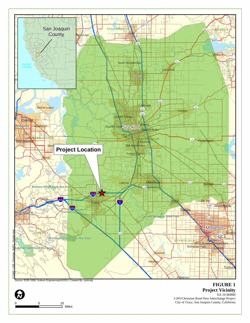
I0 5 10
Miles
Source: ESRI 2008; Dokken Engineering4/4/2012; Created By: carleneg
CA
S A N J O A Q U I N
S T A N I S L A U S
A L A M E D A
S A C R A M E N T O
S O L A N O
C O N T R A C O S T A
A M A D O R
CA
LA
VE
RA
S
Modesto
Stockton
Lodi
Livermore
Antioch
Tracy
Manteca
Oakley
Ceres
Galt
Brentwood
SalidaRiverbank
Turlock
Lathrop
Linden
Ripon
Wallace
Byron
Lockeford
Rio Vista
Discovery Bay
Knightsen
Keyes
Bethel IslandMorada
Grayson
Del Rio
Walnut Grove
French Camp
Escalon
Empire
Farmington
Westley
Garden Acres
AugustCountry Club
North Woodbridge
Bystrom
Kennedy
West ModestoRiverdale Park
Shackelford
Lincoln Village
Taft Mosswood
Patterson
§̈¦5
§̈¦580
§̈¦205
§̈¦205
UV99
UV26
UV4
UV132
UV33
UV160
UV12
UV88
UV84
UV120
UV104
UV108
UV120
UV108
UV132
UV12
UV99
UV84
UV99
UV120
UV4
UV12
UV132
UV4
UV88
Lake del Valle State Rec AreaLake del Valle State Rec Area
Carnegie St Vehicular Rec AreaCarnegie St Vehicular Rec Area
Bethany RSVR State Rec AreaBethany RSVR State Rec Area
Brannan Island State Rec AreaBrannan Island State Rec Area
Caswell Memorial State ParkCaswell Memorial State Park
V:\
19
65
_I-2
05_
Ch
rism
an
_R
d\F
1_
Vic
inity
.mxd
FIGURE 1Project Vicinity
EA 10-0H880I-205/Chrisman Road New Interchange ProjectCity of Tracy, San Joaquin County, California
_̂
PACIFIC OCEAN
San JoaquinCounty
Project Location
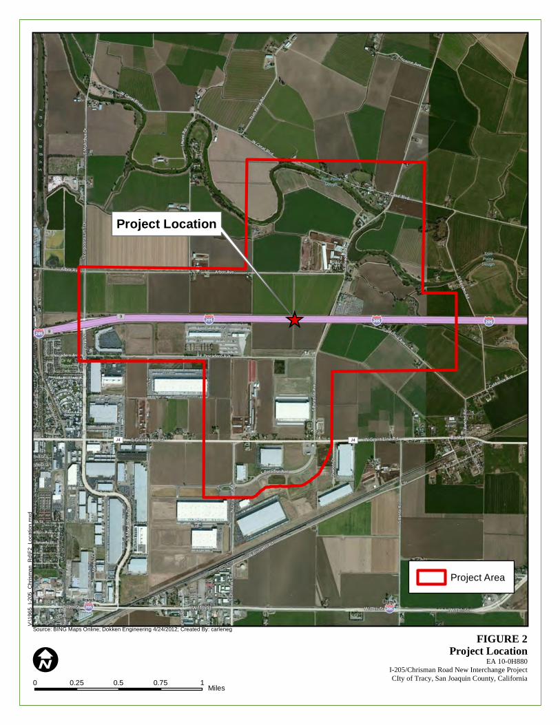
I0 0.25 0.5 0.75 1
Miles
Source: BING Maps Online; Dokken Engineering 4/24/2012; Created By: carleneg
V:\
19
65
_I-2
05_
Ch
rism
an
_R
d\F
2_
Lo
catio
n.m
xd
FIGURE 2Project Location
EA 10-0H880I-205/Chrisman Road New Interchange ProjectCIty of Tracy, San Joaquin County, California
_̂
Project Location
Project Area
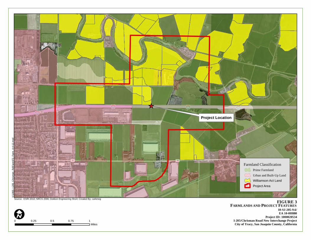
FIGURE 3
V:\
19
65
_I-2
05_
Ch
rism
an
_R
d\F
arm
\F3
_F
arm
_4
-4-1
2.m
xd
0 0.25 0.5 0.75 1Miles
IFARMLANDS AND PROJECT FEATURES
10-SJ-205-9.6/EA 10-0H880
Project ID: 1000020534I-205/Chrisman Road New Interchange ProjectCity of Tracy, San Joaquin County, California
Source: ESRI 2010; NRCS 2006; Dokken Engineering Short; Created By: carleneg
Farmland ClassificationPrime FarmlandUrban and Built-Up LandWilliamson Act Land
Project Area
_̂
Project Location
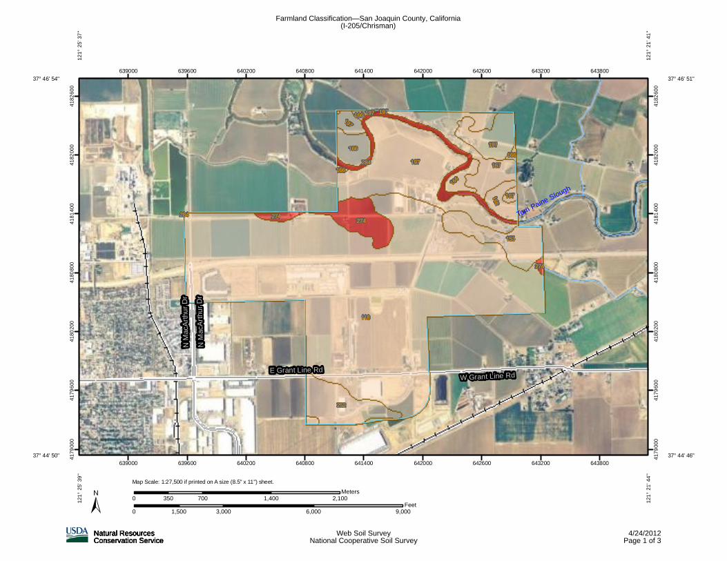
Tom Paine Slough
E Grant Line RdW Grant Line Rd
N M
acA
rthu
r D
r
N M
acA
rthu
r D
r
118
197167
252
153
274
197166
166
166
197
284
274
197
274
166
166
166
197
284
197
639000
639000
639600
639600
640200
640200
640800
640800
641400
641400
642000
642000
642600
642600
643200
643200
643800
643800
41
79
00
0
41
79
00
0
41
79
60
0
41
79
60
0
41
80
20
0
41
80
20
0
41
80
80
0
41
80
80
0
41
81
40
0
41
81
40
0
41
82
00
0
41
82
00
0
41
82
60
0
41
82
60
0
0 3,000 6,000 9,0001,500Feet
0 700 1,400 2,100350Meters
37° 46' 51''
12
1°
21
' 41
''
37° 44' 46''
12
1°
21
' 44
''
37° 44' 50''
37° 46' 54''1
21
° 2
5' 3
9''
12
1°
25
' 37
''
Map Scale: 1:27,500 if printed on A size (8.5" x 11") sheet.
Farmland Classification—San Joaquin County, California(I-205/Chrisman)
Natural ResourcesNatural ResourcesNatural ResourcesNatural ResourcesConservation ServiceConservation ServiceConservation ServiceConservation Service
Web Soil SurveyNational Cooperative Soil Survey
4/24/2012Page 1 of 3
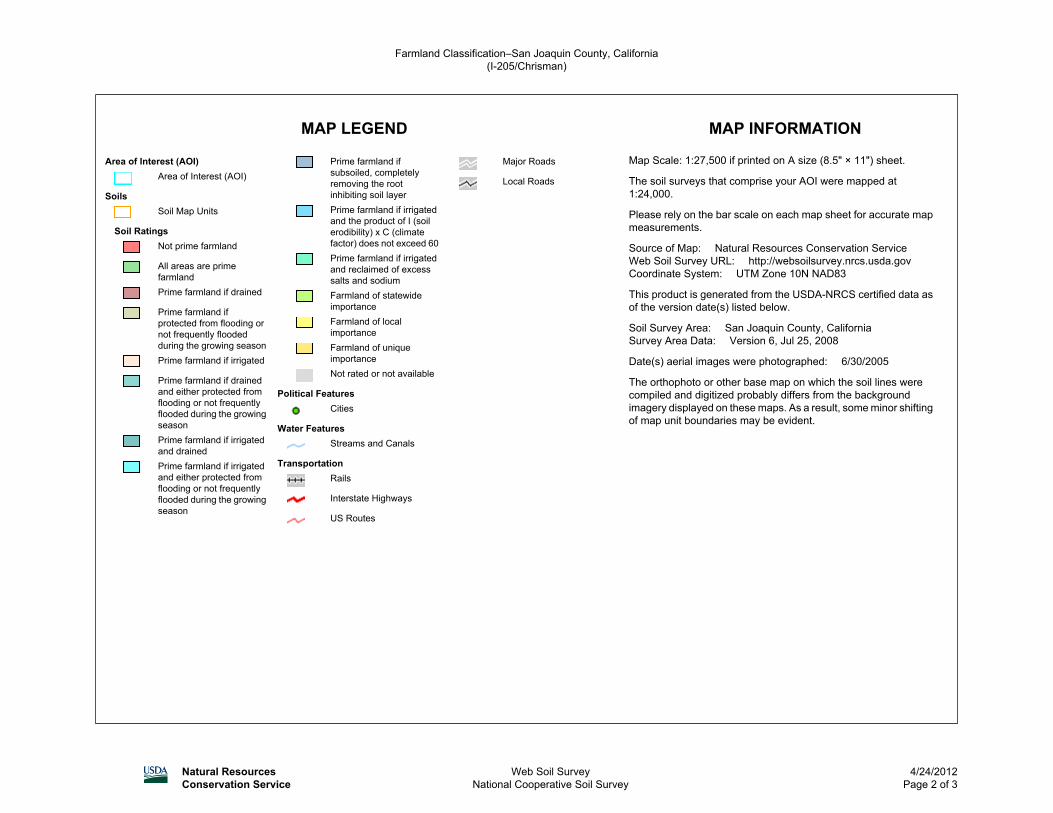
MAP LEGEND MAP INFORMATION
Area of Interest (AOI)Area of Interest (AOI)
SoilsSoil Map Units
Soil RatingsNot prime farmland
All areas are primefarmlandPrime farmland if drained
Prime farmland ifprotected from flooding ornot frequently floodedduring the growing seasonPrime farmland if irrigated
Prime farmland if drainedand either protected fromflooding or not frequentlyflooded during the growingseasonPrime farmland if irrigatedand drainedPrime farmland if irrigatedand either protected fromflooding or not frequentlyflooded during the growingseason
Prime farmland ifsubsoiled, completelyremoving the rootinhibiting soil layerPrime farmland if irrigatedand the product of I (soilerodibility) x C (climatefactor) does not exceed 60Prime farmland if irrigatedand reclaimed of excesssalts and sodiumFarmland of statewideimportanceFarmland of localimportanceFarmland of uniqueimportanceNot rated or not available
Political FeaturesCities
Water FeaturesStreams and Canals
TransportationRails
Interstate Highways
US Routes
Major Roads
Local Roads
Map Scale: 1:27,500 if printed on A size (8.5" × 11") sheet.
The soil surveys that comprise your AOI were mapped at1:24,000.
Please rely on the bar scale on each map sheet for accurate mapmeasurements.
Source of Map: Natural Resources Conservation ServiceWeb Soil Survey URL: http://websoilsurvey.nrcs.usda.govCoordinate System: UTM Zone 10N NAD83
This product is generated from the USDA-NRCS certified data asof the version date(s) listed below.
Soil Survey Area: San Joaquin County, CaliforniaSurvey Area Data: Version 6, Jul 25, 2008
Date(s) aerial images were photographed: 6/30/2005
The orthophoto or other base map on which the soil lines werecompiled and digitized probably differs from the backgroundimagery displayed on these maps. As a result, some minor shiftingof map unit boundaries may be evident.
Farmland Classification–San Joaquin County, California(I-205/Chrisman)
Natural ResourcesConservation Service
Web Soil SurveyNational Cooperative Soil Survey
4/24/2012Page 2 of 3
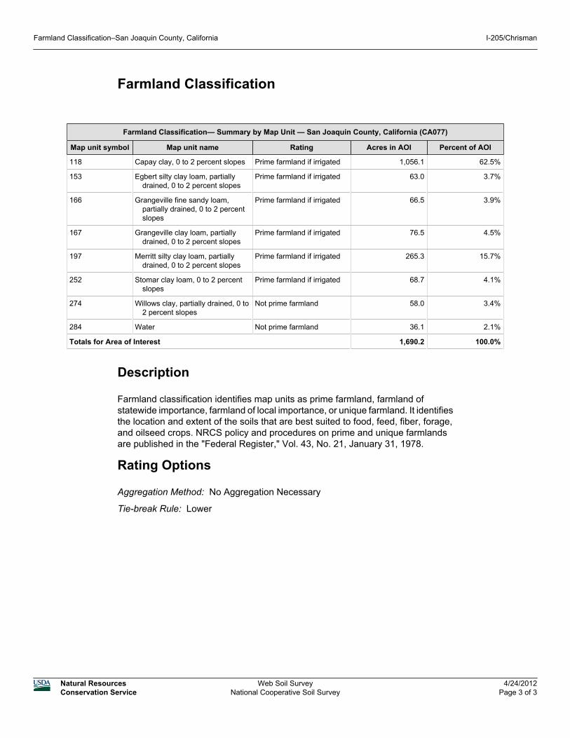
Farmland Classification
Farmland Classification— Summary by Map Unit — San Joaquin County, California (CA077)
Map unit symbol Map unit name Rating Acres in AOI Percent of AOI
118 Capay clay, 0 to 2 percent slopes Prime farmland if irrigated 1,056.1 62.5%
153 Egbert silty clay loam, partiallydrained, 0 to 2 percent slopes
Prime farmland if irrigated 63.0 3.7%
166 Grangeville fine sandy loam,partially drained, 0 to 2 percentslopes
Prime farmland if irrigated 66.5 3.9%
167 Grangeville clay loam, partiallydrained, 0 to 2 percent slopes
Prime farmland if irrigated 76.5 4.5%
197 Merritt silty clay loam, partiallydrained, 0 to 2 percent slopes
Prime farmland if irrigated 265.3 15.7%
252 Stomar clay loam, 0 to 2 percentslopes
Prime farmland if irrigated 68.7 4.1%
274 Willows clay, partially drained, 0 to2 percent slopes
Not prime farmland 58.0 3.4%
284 Water Not prime farmland 36.1 2.1%
Totals for Area of Interest 1,690.2 100.0%
Description
Farmland classification identifies map units as prime farmland, farmland ofstatewide importance, farmland of local importance, or unique farmland. It identifiesthe location and extent of the soils that are best suited to food, feed, fiber, forage,and oilseed crops. NRCS policy and procedures on prime and unique farmlandsare published in the "Federal Register," Vol. 43, No. 21, January 31, 1978.
Rating Options
Aggregation Method: No Aggregation Necessary
Tie-break Rule: Lower
Farmland Classification–San Joaquin County, California I-205/Chrisman
Natural ResourcesConservation Service
Web Soil SurveyNational Cooperative Soil Survey
4/24/2012Page 3 of 3
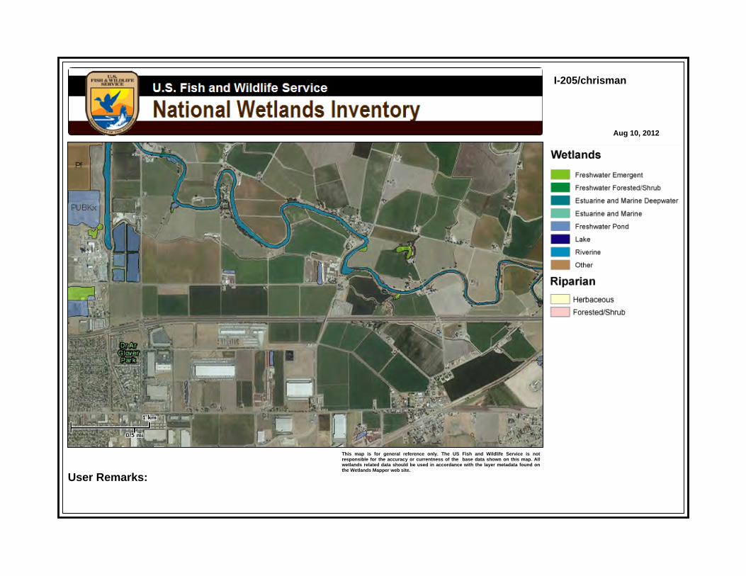
I-205/chrisman
Aug 10, 2012
This map is for general reference only. The US Fish and Wildlife Service is notresponsible for the accuracy or currentness of the base data shown on this map. Allwetlands related data should be used in accordance with the layer metadata found onthe Wetlands Mapper web site.
User Remarks:
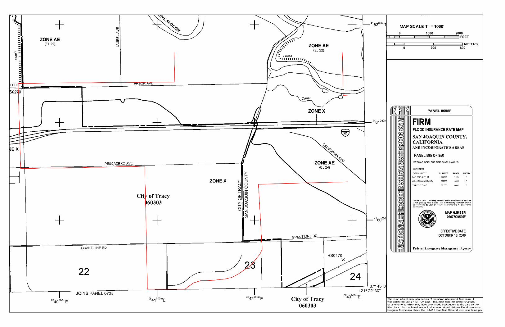


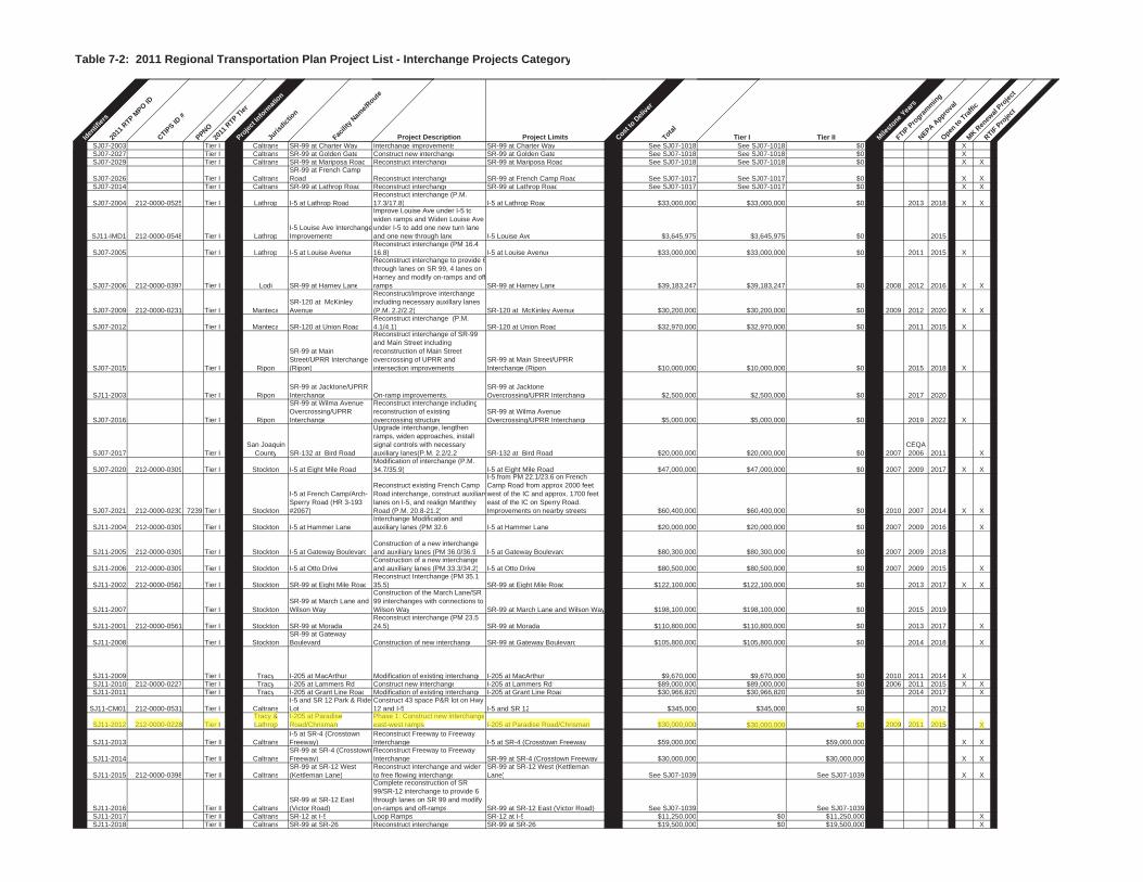
Table 7-2: 2011 Regional Transportation Plan Project List - Interchange Projects Category
Iden
tifie
rs20
11RTP
MPO ID
CTIPS ID
#
PPNO20
11RTP
Tier
Proje
ctIn
form
atio
n
Juris
dictio
n
Facili
ty N
ame/
Route
Project Description Project Limits Costto
Del
iver
Total
Tier I Tier II Mile
stone
Years
FTIP P
rogra
mm
ing
NEPA Appro
val
Opento
Traffi
cM
K Ren
ewal
Pro
ject
RTIFPro
ject
SJ07-2003 Tier I Caltrans SR-99 at Charter Way Interchange improvements SR-99 at Charter Way See SJ07-1018 See SJ07-1018 $0 XSJ07-2027 Tier I Caltrans SR-99 at Golden Gate Construct new interchange SR-99 at Golden Gate See SJ07-1018 See SJ07-1018 $0 XSJ07-2029 Tier I Caltrans SR-99 at Mariposa Road Reconstruct interchange SR-99 at Mariposa Road See SJ07-1018 See SJ07-1018 $0 X X
SJ07-2026 Tier I CaltransSR-99 at French Camp Road Reconstruct interchange SR-99 at French Camp Road See SJ07-1017 See SJ07-1017 $0 X X
SJ07-2014 Tier I Caltrans SR-99 at Lathrop Road Reconstruct interchange SR-99 at Lathrop Road See SJ07-1017 See SJ07-1017 $0 X X
SJ07-2004 212-0000-0525 Tier I Lathrop I-5 at Lathrop RoadReconstruct interchange (P.M.17.3/17.8) I-5 at Lathrop Road $33,000,000 $33,000,000 $0 2013 2018 X X
SJ11-IMD1 212-0000-0548 Tier I LathropI-5 Louise Ave InterchangeImprovements
Improve Louise Ave under I-5 towiden ramps and Widen Louise Ave under I-5 to add one new turn lane and one new through lane I-5 Louise Ave $3,645,975 $3,645,975 $0 2015
SJ07-2005 Tier I Lathrop I-5 at Louise AvenueReconstruct interchange (PM 16.416.8) I-5 at Louise Avenue $33,000,000 $33,000,000 $0 2011 2015 X
SJ07-2006 212-0000-0397 Tier I Lodi SR-99 at Harney Lane
Reconstruct interchange to provide 6through lanes on SR 99, 4 lanes on Harney and modify on-ramps and offramps SR-99 at Harney Lane $39,183,247 $39,183,247 $0 2008 2012 2016 X X
SJ07-2009 212-0000-0231 Tier I MantecaSR-120 at McKinley Avenue
Reconstruct/improve interchangeincluding necessary auxillary lanes (P.M. 2.2/2.2) SR-120 at McKinley Avenue $30,200,000 $30,200,000 $0 2009 2012 2020 X X
SJ07-2012 Tier I Manteca SR-120 at Union RoadReconstruct interchange (P.M.4.1/4.1) SR-120 at Union Road $32,970,000 $32,970,000 $0 2011 2015 X
SJ07-2015 Tier I Ripon
SR-99 at Main Street/UPRR Interchange (Ripon)
Reconstruct interchange of SR-99 and Main Street including reconstruction of Main Street overcrossing of UPRR and intersection improvements
SR-99 at Main Street/UPRR Interchange (Ripon) $10,000,000 $10,000,000 $0 2015 2018 X
SJ11-2003 Tier I RiponSR-99 at Jacktone/UPRR Interchange On-ramp improvements.
SR-99 at Jacktone Overcrossing/UPRR Interchange $2,500,000 $2,500,000 $0 2017 2020
SJ07-2016 Tier I Ripon
SR-99 at Wilma Avenue Overcrossing/UPRRInterchange
Reconstruct interchange includingreconstruction of existing overcrossing structure
SR-99 at Wilma Avenue Overcrossing/UPRR Interchange $5,000,000 $5,000,000 $0 2019 2022 X
SJ07-2017 Tier ISan Joaquin
County SR-132 at Bird Road
Upgrade interchange, lengthenramps, widen approaches, install signal controls with necessary auxiliary lanes(P.M. 2.2/2.2 SR-132 at Bird Road $20,000,000 $20,000,000 $0 2007
CEQA2006 2011 X
SJ07-2020 212-0000-0309 Tier I Stockton I-5 at Eight Mile Road Modification of interchange (P.M. 34.7/35.9) I-5 at Eight Mile Road $47,000,000 $47,000,000 $0 2007 2009 2017 X X
SJ07-2021 212-0000-0230 7239 Tier I Stockton
I-5 at French Camp/Arch-Sperry Road (HR 3-193 #2067)
Reconstruct existing French Camp Road interchange, construct auxiliarylanes on I-5, and realign Manthey Road (P.M. 20.8-21.2)
I-5 from PM 22.1/23.6 on French Camp Road from approx 2000 feet west of the IC and approx. 1700 feet east of the IC on Sperry Road.Improvements on nearby streets $60,400,000 $60,400,000 $0 2010 2007 2014 X X
SJ11-2004 212-0000-0309 Tier I Stockton I-5 at Hammer LaneInterchange Modification andauxiliary lanes (PM 32.6 I-5 at Hammer Lane $20,000,000 $20,000,000 $0 2007 2009 2016 X
SJ11-2005 212-0000-0309 Tier I Stockton I-5 at Gateway BoulevardConstruction of a new interchange and auxiliary lanes (PM 36.0/36.9 I-5 at Gateway Boulevard $80,300,000 $80,300,000 $0 2007 2009 2018
SJ11-2006 212-0000-0309 Tier I Stockton I-5 at Otto DriveConstruction of a new interchangeand auxiliary lanes (PM 33.3/34.2) I-5 at Otto Drive $80,500,000 $80,500,000 $0 2007 2009 2015 X
SJ11-2002 212-0000-0562 Tier I Stockton SR-99 at Eight Mile RoadReconstruct Interchange (PM 35.135.5) SR-99 at Eight Mile Road $122,100,000 $122,100,000 $0 2013 2017 X X
SJ11-2007 Tier I StocktonSR-99 at March Lane and Wilson Way
Construction of the March Lane/SR99 interchanges with connections to Wilson Way SR-99 at March Lane and Wilson Way $198,100,000 $198,100,000 $0 2015 2019
SJ11-2001 212-0000-0561 Tier I Stockton SR-99 at MoradaReconstruct interchange (PM 23.524.5) SR-99 at Morada $110,800,000 $110,800,000 $0 2013 2017 X
SJ11-2008 Tier I StocktonSR-99 at Gateway Boulevard Construction of new interchange SR-99 at Gateway Boulevard $105,800,000 $105,800,000 $0 2014 2018 X
SJ11-2009 Tier I Tracy I-205 at MacArthur Modification of existing interchange I-205 at MacArthur $9,670,000 $9,670,000 $0 2010 2011 2014 XSJ11-2010 212-0000-0227 Tier I Tracy I-205 at Lammers Rd Construct new interchange I-205 at Lammers Rd $89,000,000 $89,000,000 $0 2006 2011 2015 X XSJ11-2011 Tier I Tracy I-205 at Grant Line Road Modification of existing interchange I-205 at Grant Line Road $30,966,820 $30,966,820 $0 2014 2017 X
SJ11-CM01 212-0000-0531 Tier I CaltransI-5 and SR 12 Park & Ride Lot
Construct 43 space P&R lot on Hwy 12 and I-5 I-5 and SR 12 $345,000 $345,000 $0 2012
SJ11-2012 212-0000-0228 Tier ITracy & Lathrop
I-205 at Paradise Road/Chrisman
Phase 1: Construct new interchangeeast-west ramps I-205 at Paradise Road/Chrisman $30,000,000 $30,000,000 $0 2009 2011 2015 X
SJ11-2013 Tier II CaltransI-5 at SR-4 (Crosstown Freeway)
Reconstruct Freeway to Freeway Interchange I-5 at SR-4 (Crosstown Freeway) $59,000,000 $59,000,000 X X
SJ11-2014 Tier II CaltransSR-99 at SR-4 (Crosstown Freeway)
Reconstruct Freeway to Freeway Interchange SR-99 at SR-4 (Crosstown Freeway) $30,000,000 $30,000,000 X X
SJ11-2015 212-0000-0398 Tier II CaltransSR-99 at SR-12 West (Kettleman Lane)
Reconstruct interchange and widento free flowing interchange
SR-99 at SR-12 West (Kettleman Lane) See SJ07-1039 See SJ07-1039 X X
SJ11-2016 Tier II CaltransSR-99 at SR-12 East (Victor Road)
Complete reconstruction of SR 99/SR-12 interchange to provide 6 through lanes on SR 99 and modify on-ramps and off-ramps SR-99 at SR-12 East (Victor Road) See SJ07-1039 See SJ07-1039
SJ11-2017 Tier II Caltrans SR-12 at I-5 Loop Ramps SR-12 at I-5 $11,250,000 $0 $11,250,000 XSJ11-2018 Tier II Caltrans SR-99 at SR-26 Reconstruct interchange SR-99 at SR-26 $19,500,000 $0 $19,500,000 X
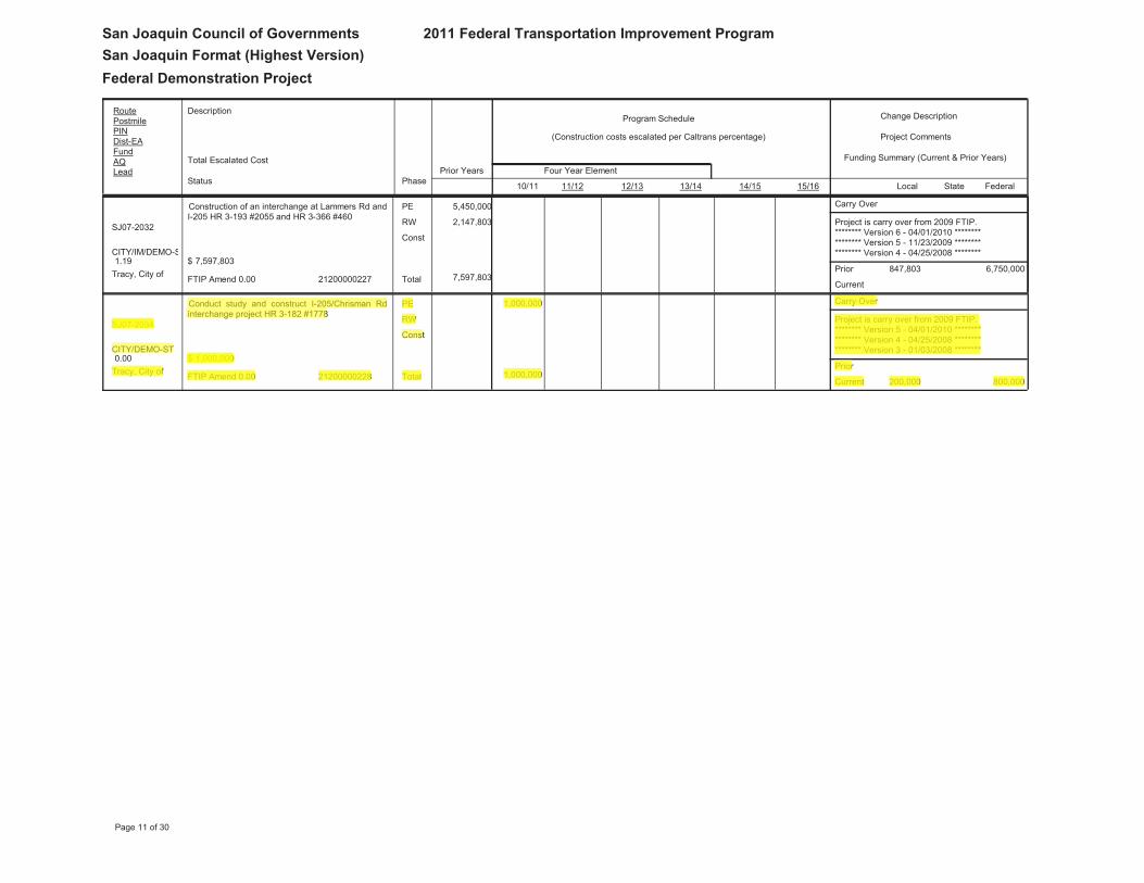
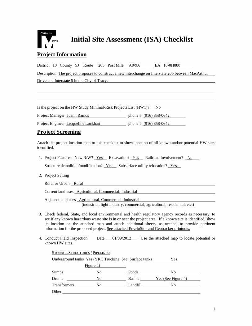
1
etric
Caltrans
Initial Site Assessment (ISA) Checklist
Project Information District _10_ County _SJ _ Route __205_ Post Mile __9.0/9.6______ EA _10-0H880______
Description The project proposes to construct a new interchange on Interstate 205 between MacArthur
Drive and Interstate 5 in the City of Tracy.
Is the project on the HW Study Minimal-Risk Projects List (HW1)? No
Project Manager Juann Ramos phone # (916) 858-0642
Project Engineer Jacqueline Lockhart phone # (916) 858-0642
Project Screening Attach the project location map to this checklist to show location of all known and/or potential HW sites identified. 1. Project Features: New R/W? _Yes__ Excavation? _Yes__ Railroad Involvement? _No___
Structure demolition/modification? _Yes__ Subsurface utility relocation? _Yes__ 2. Project Setting
Rural or Urban Rural
Current land uses Agricultural, Commercial, Industrial
Adjacent land uses Agricultural, Commercial, Industrial (industrial, light industry, commercial, agricultural, residential, etc.)
3. Check federal, State, and local environmental and health regulatory agency records as necessary, to
see if any known hazardous waste site is in or near the project area. If a known site is identified, show its location on the attached map and attach additional sheets, as needed, to provide pertinent information for the proposed project. See attached EnvrioStor and Geotracker printouts.
4. Conduct Field Inspection. Date ___01/09/2012___ Use the attached map to locate potential or
known HW sites.
STORAGE STRUCTURES / PIPELINES:
Underground tanks Yes (YRC Trucking, See Surface tanks Yes
Figure 4)
Sumps No Ponds No
Drums No Basins Yes (See Figure 4)
Transformers No Landfill No
Other
2
Initial Site Assessment (ISA) Checklist (continued)
CONTAMINATION: (spills, leaks, illegal dumping, etc.)
Surface staining Possible (Travlin Toys, Oil sheen No See Figure 4)
Odors No Vegetation damage No
Other
HAZARDOUS MATERIALS: (asbestos, lead, etc.)
Buildings Yes (Travlin Toys and Haley Spray-on fireproofing Unknown Flying Service, See Figure 4)
Pipe wrap Unknown Friable tile Unknown
Acoustical plaster Unknown Serpentine Unknown
Paint Unknown Other
5. Additional record search, as necessary, of subsequent land uses that could have resulted in a hazardous
waste site. Use the attached map to show the location of potential hazardous waste sites. See attached Figure 4.
6. Other comments and/or observations: There are agricultural properties within the project vicinity
which have the potential for pesticide/herbicide contaminants. There are also dairy operations within
the project vicinity which have the potential to contain hazardous materials onsite. (See attached
Figure 4)
ISA Determination Does the project have potential hazardous waste involvement? _Yes__ If there is known or potential hazardous waste involvement, is additional ISA work needed before task orders can be prepared for the Investigation? __No__ If "YES," explain; then give an estimate of additional time required:
ISA Conducted by _Jacqueline Lockhart, PE________ Date _8/14/12__
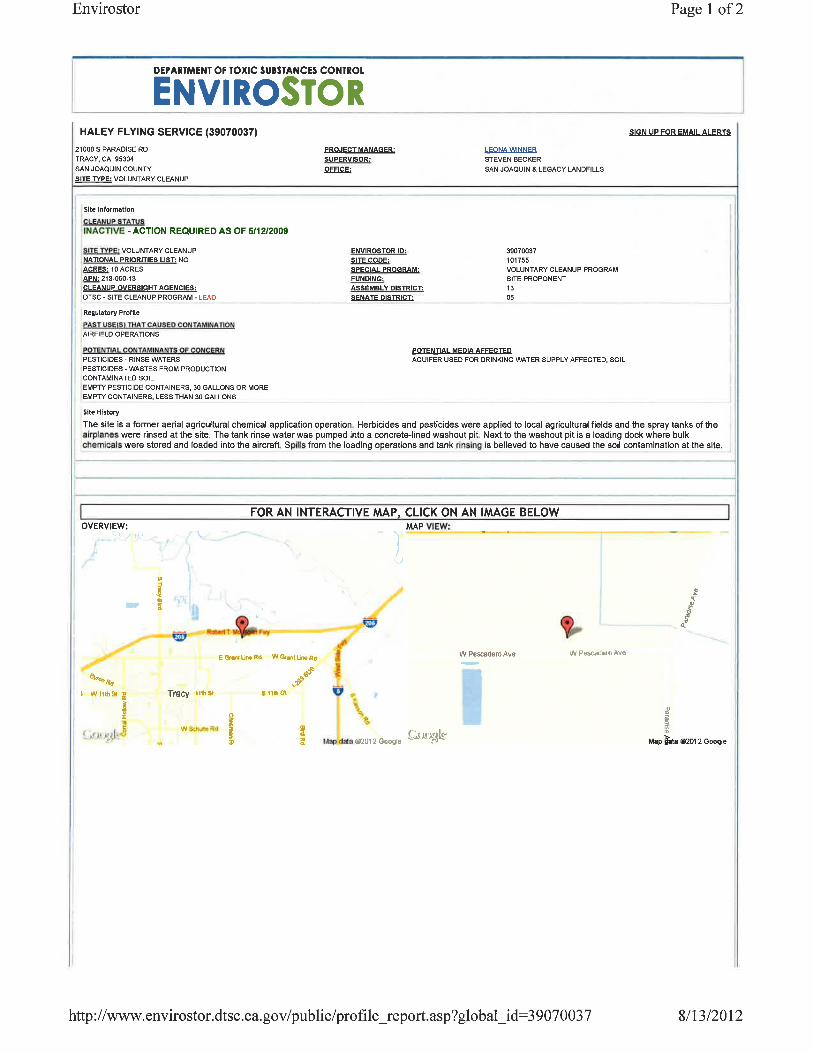
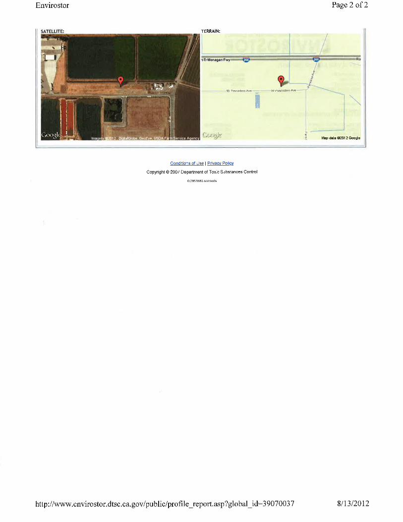
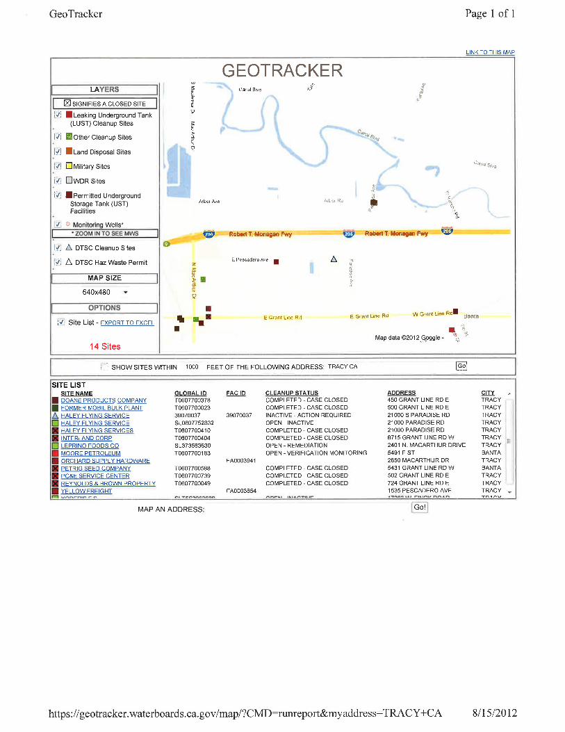
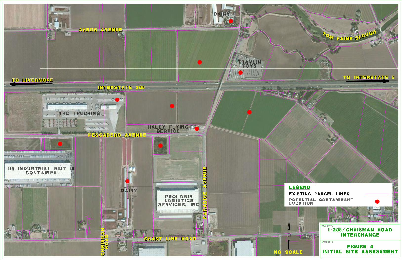

Bir d
Rd
Byron Rd
Chr
isman
Rd
Canal Bl
Han
sen
Rd
B an t
a Rd
Mac
Ar t
hur
Dr
Cor
ral H
oll o
w R
d
Tra
c y B
lvd
Bethany Rd
Grant Line Rd
Valpico Rd
Mou
nta i
n H
ouse
Pk w
y
Ho l
ly D
r
L am
me r
s Rd
Lowell Ave
Delta Ave
Von Sosten Rd
Middle Rd
Tennis Ln
East
St
Grant Line Rd
Mac
Ar t
hur
Dr
Byron Rd
Arbor Ave
Nag
lee
Rd
Lin
coln
Blv
d
Pescadero Ave
Lehman Rd
Ald
er A
ve
Berry
Ave
Valpico Rd
California A
ve
Brichetto Rd
Larch Rd
Sixth St
Cedar
Ave
Eleventh St
N H
icko
ry A
ve
Chr
is man
Rd
Bates Rd
Third St
Clover Rd
Egre
t D
r
Cabe Rd
Lind
y W
y
Eleve
nth St
Linne Rd
Eleventh St
Cor
ral H
ollo
w R
d
T rac
y Bl
v dTr
acy
Blvd
L am
me r
s Rd
Schulte Rd
FIGURE 2-2
G E N E R A L P L A NL A N D U S E D E S I G N A T I O N S
C I T Y O F T R A C Y
G E N E R A L P L A NL A N D U S E E L E M E N T
0 0.25 0.5 Miles
Sphere of Influence
City Limits
Residential Very Low
Residential Low
Residential Medium
Residential High
Traditional Residential - Ellis
Commercial
Office
Industrial
Downtown
Village Center
Public Facilities
Park
Open Space
Agriculture
Aggregate
Urban Reserve
1 acre50 acres
200 acres
100 acres
640 acres(1 sq. mile)
Major Arterial/Expressway/BoulevardEleventh St
Sixth St
Third St
Cen
tral A
ve
Downtown Area Detail 0 1,250 2,500625 Feet
Tracy Municipal Airport
UR 1
UR 2
UR 3
UR 4
UR 5
UR 6
UR 7
UR 8
UR 9
UR 10
UR
ATTACHMENT H
Risk Register
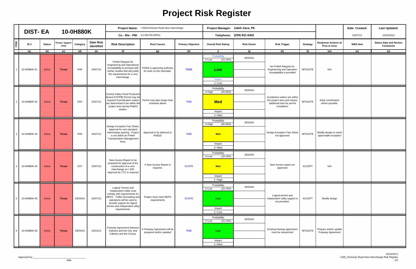
Project Risk Register
Project Name: Project Manager: Risks sorted by Date Created: Last Updated:
Co - Rte - PM: Telephone: 02/07/12 10/10/2012
ITE
M
ID # StatusThreat / Opport-
unityCategory
Date Risk Identified
Risk Description Root Causes Primary Objective Overall Risk Rating Risk Owner Risk Trigger StrategyResponse Actions w/
Pros & ConsWBS Item
Status Date and Review Comments
(a) (b) (c) (d) (e) (f) (g) (h) i) (j) (k) (l) (m) (n) (o)
Probablility
2=Low (10-19%)
Impact
2 =Low
Probablility
4=High (40-59%)
Impact
3 =Med
Probablility
4=High (40-59%)
Impact
3 =Med
Probablility
2=Low (10-19%)
Impact
4 =High
Probablility
2=Low (10-19%)
Impact
2 =Low
Probablility
2=Low (10-19%)
Impact
3 =Med
Zabih Zaca, PE
(209) 831-6452DIST- EA 10-0H880K
Jursidiction waters are within the project area and require
additional time for permit completion
MITIGATETIMEENV 02/07/12
Central Valley Flood Protection Board (CVFPB) Permit may be required if jurisdication waters are determined to be within the
project area during PA&Ed studies.
Permit may take longer than schedule allows
New Access Report to be prepared for approval of the
construction of a new interchange on I-205.
Approval by CTC is required
DESIGN 03/15/12
EXT 02/07/12
Freeway Agreement between Caltrans and the City, and Caltrans and the County.
DESIGN
TIME
Threat
02/07/12
10-0H880K-04 Active
5
1 10-0H880K-01 Active
3 10-0H880K-03 Active
Logical Termini and Independent Utility must
comply with requirements for NEPA. Traffic forecasting and
operations will be used to provide support for logical
termini and independent utility requirements.
2 10-0H880K-02 Active Threat
Design Exception Fact Sheet. Approval for non-standard
interchange spacing. Project is not within an FHWA
Transportation Management Area.
Active Threat10-0H880K-05
4
TIMER/WThreat
Threat
FHWA is approving authority for work on the Interstate.
04/07/12
FHWA Request for Engineering and Operational Acceptability to proceed with further studies that will justify the requirements for a new
interchange.
R/W 04/07/12Approval to be deferred to
PA&ED
DESIGN
Existing freeway agreement must be researched
MITIGATEPrepare and/or update Freeway Agreement
DESIGN
Early coordination where possible.
N/A
DESIGN
MITIGATE
Med
DESIGN
No FHWA Request for Engineering and Operation
Acceptability is provided
Design Exception Fact Sheet not approved
Low
MedModify design to reach approvable exception
MITIGATE
Modify design
N/AA New Access Report is
required.
DESIGN
New Access report not approved
ACCEPT
6 10-0H880K-06 Active Threat
Project must meet NEPA requirements
DESIGN
Logical termini and independent utility support is
not provided.
Low
Med
ACCEPT
I-205/Chrisman Road New Interchange
SJ-205-R9.0/R9.6
SCOPE
A Freeway Agreement will be prepared and/or updated
TIME
LowSCOPE
Approved by:________________________________________ date
10/10/2012I-205_Chrisman Road New Interchange Risk Register
1/2
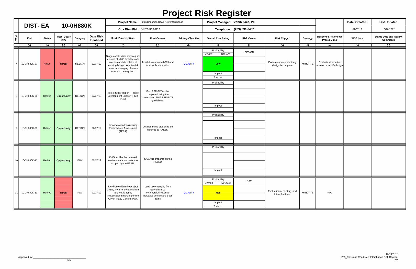
Project Risk Register Project Name: Project Manager: Risks sorted by Date Created: Last Updated:
Co - Rte - PM: Telephone: 02/07/12 10/10/2012
ITE
M
ID # StatusThreat / Opport-
unityCategory
Date Risk Identified
Risk Description Root Causes Primary Objective Overall Risk Rating Risk Owner Risk Trigger StrategyResponse Actions w/
Pros & ConsWBS Item
Status Date and Review Comments
(a) (b) (c) (d) (e) (f) (g) (h) i) (j) (k) (l) (m) (n) (o)
Zabih Zaca, PE
(209) 831-6452DIST- EA 10-0H880K
I-205/Chrisman Road New Interchange
SJ-205-R9.0/R9.6
Probablility
2=Low (10-19%)
Impact
2 =Low
Probablility
Impact
Probablility
Impact
Probablility
Impact
Probablility
3=Med (20-39%)
Impact
3 =Med
N/AEvaluation of existing and
future land useMITIGATE
R/W
R/W 02/07/12
Land Use within the project vicinity is currently agricultural
land but is zoned industrial/commercial per the City of Tracy General Plan.
11 10-0H880K-11 Retired Threat
IS/EA will be the required environmental document as
scoped by the PEAR.
IS/EA will prepared during PA&ED
10 10-0H880K-10 Retired Opportunity ENV 02/07/12
DESIGN9 10-0H880K-09 Retired Opportunity 02/07/12Transporation Engineering Performance Assessment
(TEPA)
Stage construction may require closure of I-205 for falsework
erection and demolition of existing bridge. A potential detour and staging of ramps
may also be required.
Opportunity DESIGN 02/07/12Project Study Report - Project Development Support (PSR-
PDS)
DESIGN 02/07/12
First PSR-PDS to be completed using the
streamlined 2011 PSD-PDS guidelines
7 10-0H880K-07 Active MITIGATEEvaluate alternative
access or modify designEvaluate once preliminary
design is complete
Detailed traffic studies to be deferred to PA&ED
Threat
8 10-0H880K-08 Retired
Avoid distruption to I-205 and local traffic circulation
QUALITY
MedQUALITY
Land use changing from agricultural to
commercial/industrial increases vehicle and truck
traffic
Low
DESIGN
Approved by:________________________________________ date
10/10/2012I-205_Chrisman Road New Interchange Risk Register
2/2
ATTACHMENT I
Storm Water Data Report Cover Page
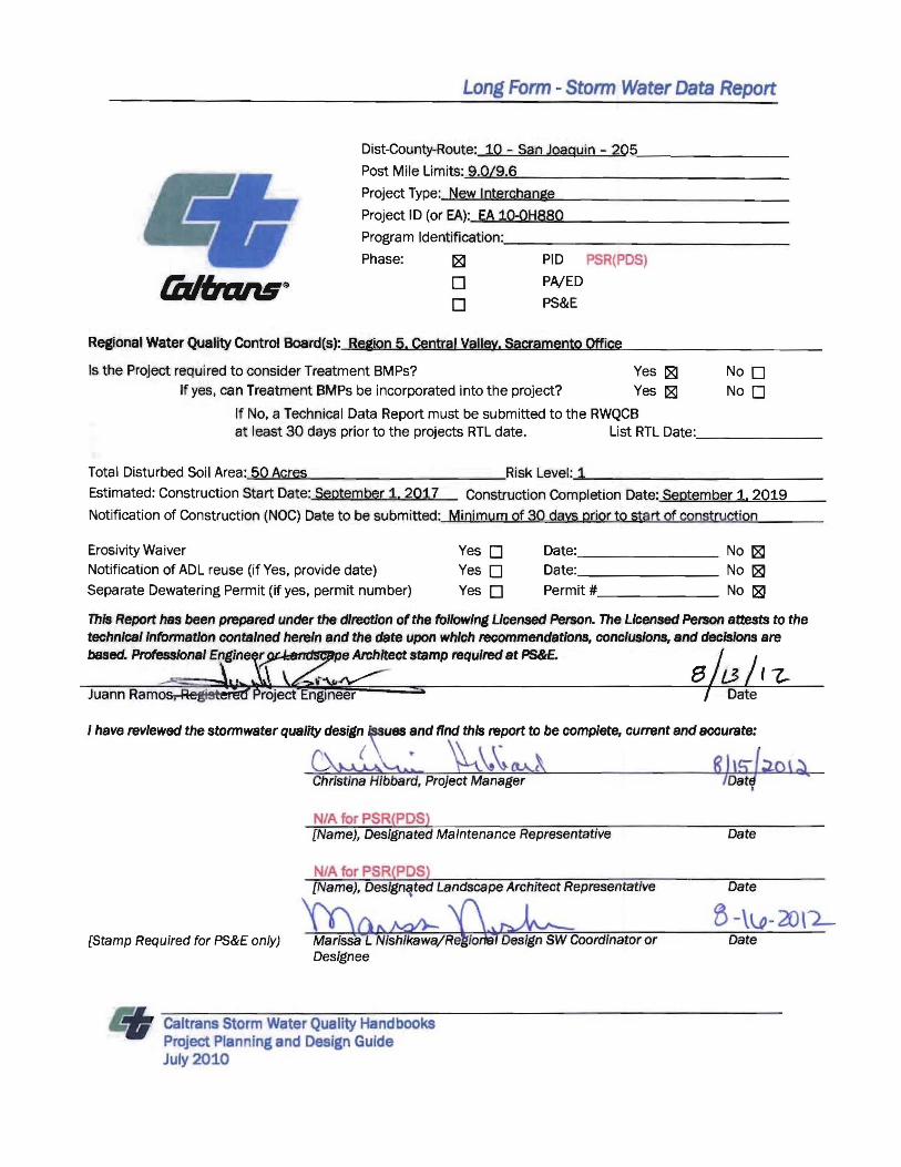
Long Form - Stonn Water Data Report
Dist-County-Route: 10 ,- San Joaquin - 205
Post Mile Limits: ......9....,.0"'1......9....,.6......______________
Project Type: New Interchange
Project 10 (or EA):--'E....A....1...0....-Q....H.....,8...8....0<--___________
Program Identification: ___ _ ___ _________
Phase: 181 PID PSR(PDS)
o PAlED
o PS&E
Regional' Water Quality Control Board(s): Region 5. Central Valley. Sacramento Office
Is the Project required to consider Treatment BMPs? Yes 181 No 0 If yes, can Treatment BMPs be incorporated into the project? Yes [81 No 0
If No, a Technical Data Report must be submitted to the RWQCB at least 30 days prior to the projects RTL date. List RTL Date:,_______
Total Disturbed Soil Area:-"5<.>0'-'A...,c.....re..,s><--____ _ ~~ ___Risk Level:-=l _______________
Estimated: Construction Start Date: September i. 2017 Construction Completion Date: September 1. 2019
Notification of Construction (NOC) Date to be submitted: Minimum of 30 days prior to start of construction
Erosivity Waiver Yes 0 Date:_______ No 181 Notification of ADL reuse (if Yes, provide date) Yes 0 Date: No 181 Separate Dewatering Permit (if yes, permit number) Yes 0 Permit # No 181
This Report has been prepared under the direct/on of the following Ucensed Petson. The Licensed Person attests to the technlcsl'nformat'on contained herein and the date upon which recommendatIons, conclusions, and decisions are based. Professional Et)gine r e Architect stamp required at PS&£
Juann Ramo ,
I have reviewed the storm water quality design ues and find this report to be complete, current and accurate:
{
N/A for PSR(PDS) [Name), Designated Maintenance Representative Date
NJA for PSR(PDS) [Name), Des/gn~ted Landscape Architect Representative Date
[Stamp Required for PS&E only) B-\\..Q- 20\2
Date
Caltrans Storm Water Quality Handbooks Project Planning and Design Guide July 2010