via first class and electronic mail
TRANSCRIPT

KEN E. JARRARD* ANGELA E. DAVIS
CHRISTOPHER J. HAMILTON MEGAN N. MARTIN KENNETH P. ROBIN
PATRICK D. JAUGSTETTER PAUL B. FRICKEY
JEFFREY M. STRICKLAND
Limited Liability Partnership
222 Webb Street Cumming, Georgia 30040
TELEPHONE: 678.455.7150 FACSIMILE: 678.455.7149
*Also Admitted in Tennessee Ꞌ Also Admitted in Florida
G. AARON MEYER MOLLY N. ESSWEIN
PATRICK DOYLE DODSON* MELISSA A. KLATZKOWꞋ
KAREN P. PACHUTA KATHLEEN A. TAYLOR
DENNIS C. BOST II PRIYA M. PATEL
September 24, 2021
VIA FIRST CLASS AND ELECTRONIC MAIL Mayor Lori Henry City of Roswell 38 Hill Street, Suite 115 Roswell, Georgia 30075 [email protected] Re: Investigative Report
City of Roswell SR 9 and Oxbo Road Intersection Improvement Project
CONFIDENTIAL: ATTORNEY-CLIENT PRIVILEGED COMMUNICATION
Dear Mayor Henry, This Firm was engaged by the City of Roswell (“City”) to conduct an investigation of the City’s intersection realignment project at SR9/Atlanta Street and Oxbo Road (the “Project”) from its origin to the present date. Due to the volume of information and activity over the 15-year period that encompasses the Project, the investigation has taken some time to ensure a thorough and complete review. We appreciate your patience throughout this process and the cooperation of the Mayor’s Office and the City staff. We present this Investigative Report with our findings.0F
1
I. SCOPE OF INVESTIGATION
A. Phase I – Record Review Phase I of our investigation commenced with requests for Project-related documents and information from multiple internal City departments (City Clerk, Purchasing, Transportation, 1 In our retention agreement, we suggested that detailed reports would be prepared and presented to you upon completion of each phase of our investigation. While we did periodically provide updates as to our progress, once the investigation began, it became clear that any substantive reporting and best practices recommendations should be held and delivered only after completing all phases of the investigation.

JARRARD & DAVIS, LLP Page 2 of 25 Finance, Human Resources, and the City Attorney) for our review and analysis. From the City Clerk, we received and reviewed more than 68 separate files containing over 750 documents, including Transportation Committee and City Council meeting minutes, purchase and sale agreements, vendor contracts, subject property easements and deeds, and other documents and information that corresponds to those meetings dating back over a 15-year period from 2006 to 2021. We also received and reviewed multiple files from the City’s Purchasing Department containing solicitation documents, responsive bids, contracts, documents, and other information related to the City’s procurement of vendors that have worked on various aspects of the Project, including early design and engineering work, structure removal and demolition work, geotechnical and survey work, and road construction work.
From the Transportation Department, we received and reviewed over 56 separate files containing more than 175 documents corresponding to a Project timeline prepared by staff dating back over a 15-year period from 2006 to 2021. This included Project information related to roadway concept and design evolution, preliminary engineering tasks, design and engineering concept data, TSPLOST, right-of-way acquisition, Phase 1 Cultural Resources Survey to the U.S. Army Corps of Engineers, structure removal and demolition, property acquisitions, utility relocation, and road construction. We also received and reviewed seven (7) banker boxes full of Project files that Clyde Stricklin (the City’s former Land Development Manager) maintained during his tenure with the City until his resignation in June 2019. These file boxes contain thousands of pages of material compiled over time related to the Project and the real property interests impacted thereby (i.e., hard copy documents related to the twenty-five (25) separate tax parcels impacted by the proposed construction of the Project).
From the City’s Human Resources Department we received and reviewed employment
files for both Steve Acenbrak and Clyde Stricklin; from the Finance Department we received and reviewed invoice and payment information for Project expenditures made over the Project period; and from the City Attorney, we received and reviewed various agreement documents, background information, and notes from multiple executive session meetings with the Mayor and City Council (the “MCC”) specifically related to ongoing Project discussions, negotiations, agreements, claims, and settlement considerations. Following our review of the information provided by the City departments, we communicated with multiple vendors who worked on the Project over the years to request information directly from them. We requested and reviewed documents and information from Mulkey Engineers & Consultants (now NV5 Engineers and Consultants, Inc.) (engineering and design), Clark Patterson Lee (“CPL”) (engineering and design), Urey Companies, LLC (road construction), Vanasse Hangen Brustlin, Inc. (site evaluation), S&ME, Inc. (geotechnical and materials testing), E.R. Snell Contractor, Inc. (road construction), Polatty & Sullivan (legal work), McDaniel & Scott, P.C. (legal work), Westfall LLC (legal work), Bates-Long & Associates, Inc. (surveyors), and Carr, Rahn & Associates (appraisers). Altogether, we received and reviewed over ten thousand pages of information related to the Project as a part of our Phase

JARRARD & DAVIS, LLP Page 3 of 25 I record review.1 F
2
B. Phase II – Witness Interviews
Phase II of our investigation consisted of conducting interviews with individuals who have been directly involved in the Project, to wit: David Davidson, City Attorney; Muhammad Rauf, Transportation Department Director; Rob Dell-Ross, Transportation Department Deputy Director; Greg Nichols, Engineering Manager; Claire Bruce, Land Acquisition Coordinator; Clyde Stricklin, former Land Development Manager; and Steve Acenbrak, former Transportation Department Director. Some employees have been around since the Project’s earliest days in 2006. We also interviewed Kay Love, the former City Administrator from 2007 to May 2017, Mayor Lori Henry, and former Mayor Jere Wood. In addition, we sent a general inquiry to certain former and all present City Council members, seeking any particularized information they may have to provide. None of the former or present City Council members who we contacted provided any information. Throughout our investigation, we found no indication that any of the City’s elected officials had any personal or individual involvement in the Oxbo Road Project or sought to provide any individual direction to City staff regarding the Project outside of the official approvals by the City Council. 2F
3
C. Expert Consultant Involvement
Pursuant to our recommendation and the City’s approval at the outset of our involvement in this matter, we also engaged an expert consultant, Angela Snyder, P.E., President of Practical Design Partners, LLC (“PDP”), for the purpose of providing technical and engineering review of the design and engineering documents and information, the right-of-way plans, the construction agreement documents, and the general progression of the Project. PDP also participated in the interviews of the Transportation Department personnel (past and present) referenced above, and, to a degree, the preparation of this report. A summary of “lessons learned” and best practices recommendations from PDP is attached hereto as Exhibit 1.
II. OVERVIEW OF FINDINGS The City’s documents and information show that the design and engineering vendors
engaged by the City for the Project all performed adequately under their respective agreements with the City and provided deliverables in accordance with the scope of services required. Specifically, the Project design and engineering work completed by Clark Patterson Lee (“CPL”), the prime engineering consultant on the Project, was found by PDP to be of good 2 With this report, we also provide a thumb drive of our compilation of all of the documents and materials we have received and reviewed related to the Project, which are categorized by Parcel and subject matter for your convenience. 3 At the outset of the investigation, we contemplated conducting Phase III interviews of external parties. While we had some informal communications with the various professional service providers in conjunction with the pursuit of records, we determined not to conduct formal interviews with them or any third-party property owners or citizens. We made this determination based upon the fact that we believed we had adequate information to reach conclusions about the Project and the concern that such external interviews could have a down-side for the City as the Project and potential negotiations continue and are ongoing.

JARRARD & DAVIS, LLP Page 4 of 25 quality and included design calculations and justifications to support the decisions that were made in the performance of its contract. Additionally, the work that the previous engineering consultants (NV5, formerly Mulkey Engineers & Consultants and CALYX; and RK Shah & Associates, Inc.) completed for the City regarding the Project all appeared to be consistent with a typical approach to a transportation project.
Project delays and increased costs appear to be directly attributable to the lack of a
defined funding source, the failure to have a timely utility relocation plan, and the utilization of improper and/or inefficient right-of-way acquisition procedures to acquire the real property ownership and access rights necessary for the Project. These issues are addressed in detail herein.
III. PROJECT ORIGINS (2006 – 2016)
A. Concept and Early Planning
The origins of the Project date back to 2006 when reference to the realignment of the intersection at Oxbo Road and SR 9 was included in the City’s Transportation Master Plan, stating that “GDOT has developed design concepts for these intersections that will have right-of-way impact and cost implications to the City.” See City’s Transportation Master Plan, approved on 12-11-2006, pages 5-9.
In early 2009, the City’s Community Development and Transportation Committee meeting included a discussion about the benefits of the SR9/Oxbo Road Intersection Realignment and Improvement Project and voted to approve the expenditure of up to $80,000.00 for various tests and surveys, including a topographic and boundary survey, geotechnical evaluation, and environmental study. Then, at the regular meeting of the Mayor and City Council on May 4, 2009, authorization was provided to enter into a contract with Mulkey Engineers & Consultants for engineering services for the Oxbo Road realignment in the amount of $42,430.00 to complete database preparation, a topographic survey, an environmental screening, and a geo-tech survey of the proposed road realignment of Oxbo Road, Elm Street, and Pleasant Hill Street at South Atlanta Street. These activities were represented as being standard, pre-engineering elements, intended to facilitate the complete design of the intersection by in-house staff. See MCC Regular Meeting, 05-04-2009, Agenda Packet - Legislation Text (Item Summary).
B. Acquisition of Project Parcel No. 16 from Mills
In October 2010, the Mayor and City Council approved the purchase of real property located at 15 Oxbo Road (a parcel that would later be designated as Project Parcel No. 16) from W. Curtis Mills, Jr., for $700,000.00, plus the City’s conveyance to Mills of an 0.88-acre tract located at the end of Maple Street at Vickery Creek to Mills. The property received by the City was the old 18-unit apartment complex that was purchased and subsequently torn down. Funding for the purchase was primarily through a Community Development Block Grant (“CDBG”) in the amount of $502,282.00, with the remainder of the purchase price paid from the City’s General Funds. By an appraisal dated April 23, 2010, prepared by Carr, Lawson, Cantrell & Associates, Inc., Real Estate Appraisers and Consultants, for the City, the fair market value of

JARRARD & DAVIS, LLP Page 5 of 25 the subject property that was acquired by the City was determined to be $700,000.00.
The City also received an appraisal for the above-referenced 0.88-acre tract that the City conveyed to Mills. The appraisal was prepared by Danny White & Associates for the City and is dated November 5, 2010, which is the month after the Mayor and City Council approved the transaction with Mills. The appraisal estimates the value of the 0.88-acre tract to be $75,000.00, but discounts that value down to $45,000.00 in the event the owner/developer was required by the City to pay the cost of improvements to Maple Street. 3F
4
PROBLEM: State law only authorizes the City to dispose of its real property by exchange when certain specific conditions are met. See O.C.G.A. § 36-37-6(c) regarding exchange transactions that are not specifically related to transportation projects.4F
5 It is unknown if the City timely published a notice in the official legal organ prior to closing on the exchange transaction. In addition, there was no appraisal valuation of the City’s 0.88-acre parcel included in the information considered and approved by the Mayor and City Council for the exchange transaction at the time it was approved by the Mayor and City Council. See Exhibit 2, Applicable State Law Requirements.
C. Retention of CPL
In April 2011, following a competitive solicitation (RFP#11-005-B) conducted by the City, the Mayor and City Council approved a contract with CPL for certain design and engineering work related to the Project in an amount not to exceed $435,000.00. CPL’s proposal included concept, public involvement, environmental, database preparation, preliminary plans, landscaping, right-of-way plans, and final plans. In April 2013, the Mayor and City Council approved a change order to the agreement with CPL in the amount of $28,300.00 for additional design work regarding two retaining walls that were needed at that time to accommodate Project design changes.
D. Acquisition of Project Parcel 15 from Pickens
In September 2012, the Mayor and City Council approved the acquisition of property it needed at 27 Oxbo Road (a parcel that would later be designated as Project Parcel No. 15)
4 Public records show that on or about June 21, 2017, Mills sold the 0.88-acre tract to Southern Pines Construction Group, LLC (“Southern Pines”), for $430,000.00 (see Limited Warranty Deed, dated June 21, 2017, and recorded in the Fulton County Real Property Records at Deed Book 57663, Page 294, and the corresponding PT-61). Thereafter, Southern Pines subdivided the property into three developable tracts, which are currently assigned property addresses of 69 – 77 Maple Street. 5 While the property acquired was within the area anticipated for the Project, there was no reference in the presentation related to the acquisition that it was related to a road project. Moreover, following the acquisition and the City’s demolition of the existing structure, the City explained the purposes as follows: “The removal of the structure will reduce the City’s liability and eliminate the opportunity for vandalism and stem community blight.” As such, we refer to the requirements of Title 36 for acquisition unrelated to road projects. If the acquisition were considered as part of the Project, the Title 32 requirements are applicable. Under either process, the City is only authorized to exchange property if, following an appraisal, the City will be giving up land that is worth the same or less than what it will receive. However, the Title 32 process would not require a pre-closing public notification.

JARRARD & DAVIS, LLP Page 6 of 25 from John Wesley Pickens and Patricia Ann Pickens in exchange for property the City owned at 1030 Grimes Bridge Road, which had been previously purchased by the City in 2010 as part of a roundabout project. The City received an appraisal for the property at 27 Oxbo Road, dated October 19, 2011, from LA Appraisal Services, Inc., that valued this property at $95,000.00. The City received an appraisal for the remainder interest it held at 1030 Grimes Bridge Road, dated April 9, 2012, from Carr, Lawson, Cantrell & Associates, Inc., Real Estate Appraisers and Consultants, that valued the City’s property at $92,100.00. In accordance with O.C.G.A. § 36-37-6(c), notice of the exchange was published in the North Fulton Neighborhood on October 3, 2012, the exchange transaction was closed on October 29, 2012, and deeds were exchanged between the parties and recorded.
E. Delay Due to Funding – Oxbo Drive One-Way Pair Project
In 2014, the Project was, for the most part, put on the shelf due to lack of committed project funding with the understanding at that time between the Mayor, City Council, and the City staff that the intersection realignment work would remain listed as a priority project and would be promoted as funding became available. During this time, the City did complete the Oxbo Drive One-Way Pair project at SR 9/Atlanta Street (awarded to Urey Companies, LLC, in the amount of $98,013.14) as an effort to mitigate traffic problems in the vicinity of the intersection.
F. Acquisition of Project Parcel 22 (“Doc’s Café”) from Ahmad Waliagha
In October 2016, the Mayor and City Council approved the purchase of real property at 20 Oxbo Road (aka Doc’s Café property) (a parcel that would later be designated as Project Parcel No. 22) from Ahmad Waliagha for $215,000.00. At the October 10, 2016, Mayor and City Council meeting, questions were raised by city council members and members of the public regarding the fair market value of the property. As reflected in the meeting minutes, David Davidson, City Attorney, responded that the City got an appraisal that came in lower than the proposed purchase price. Davidson later stated that the City’s appraisal was around $200,000.00, but the Seller’s appraisal was around $240,000.00. In the City’s files, there is an appraisal provided by Carr, Rahn & Associates dated September 18, 2015, which concluded that the value of the subject property, “as improved,” was $107,000.00. In the City’s files, we did locate some information from a Uniform Residential Appraisal Report dated August 27, 2015, which concluded the value of the subject property to be $230,000.00. No other appraisals for the subject property were located in the City’s files or provided in response to our requests for documents.
G. TSPLOST Approval
In 2016, the City included the Project in a proposed list of projects to be funded under a Transportation Special Purposes Local Option Sales Tax (“TSPLOST”). The City’s tier one project list included intersection improvements at Oxbo Road and SR 9. In November 2016, the voters approved the TSPLOST and the Intergovernmental Agreement (“IGA”) with Fulton County regarding TSPLOST, which included within the City’s list of projects, one project under the Operations and Safety category titled “Oxbo/SR 9 Intersection” for $7,000,000. The voter-approved TSPLOST provided the necessary Project funding. As such, following passage of the

JARRARD & DAVIS, LLP Page 7 of 25 TSPLOST, the City moved the Project forward in earnest.
IV. PROJECT DEVELOPMENT (2016 – PRESENT)
A. Amendment of CPL Agreement
In October 2017, the Community Development and Transportation Committee considered a contract modification with CPL in the amount of $239,567.00 to revise and finalize the Project design plans. Director Acenbrak explained the need for the modification to the Committee by stating that staff now had a path forward and needed the design firm (CPL) to revise the site plan and modify the design to incorporate the new right-of-way negotiations that staff had accomplished. The Mayor and City Council approved Amendment No. 1 to the CPL agreement, but not until April 2018.
B. Acquisition of Project Parcel No. 21 from Clifford Wyche
In July 2017, the Mayor and City Council approved the purchase of real property at 726 Pleasant Hill Street (Project Parcel No. 21) from Clifford Wyche for $260,000.00. The City worked on this acquisition for a number of years starting in 2015. The City received an appraisal of the property from Carr, Rahn & Associates, Inc., Real Estate Appraisers and Consultants, dated September 18, 2015, which valued the subject property at $135,520.00. The seller was represented by a local lawyer, Cam S. Head. The seller presented an appraisal from D.S. Murphy & Associates, dated April 17, 2017, which valued the subject property at $240,000.00. Nonetheless, the seller indicated he would not take less than $260,000.00. The City agreed and the transaction was closed in late July 2017.
C. Acquisition of Project Parcel No. 17 (“Hardware Store”) from Whites
By letter dated March 3, 2017, Donald Rolader, lawyer for the owners of the Roswell Hardware property located at 685 Atlanta Street (the “Hardware Store”) sent a formal offer to the City on behalf of his clients for the outright sale of their property and a release from all losses and damages they may incur for a purchase price of $6,850,000.00, the right to occupy the property until the commencement of construction, and a right of first refusal to reacquire the property if marketed by the City in the future.
At the September 12, 2017 meeting of Mayor and City Council, as reflected in the meeting minutes, Director Acenbrak stated the following in his presentation: that the Hardware Store was the biggest piece of the right-of-way because of its location within the realignment project; staff had worked with the hardware store for a number of years to get support and reach an agreement; preliminary realignment designs were not supported by the hardware store owners, but that the final design change was supported by them; the final purchase price for the property was negotiated down from $6M to $3M.
At that meeting, the Mayor and City Council approved the purchase of the Hardware Store (Parcel No. 17) from Benita White, Alfred White and Jason White for $3,000,000.00, plus 12 months post-closing continued occupancy by the sellers at the subject property for no

JARRARD & DAVIS, LLP Page 8 of 25 additional rent and an agreement to provide a developable 1-acre (+/-) tract in approximately the same location back to the sellers within three (3) years (or by October 24, 2020) at no additional cost to sellers. The only appraisal information received and reviewed was dated March 5, 2013, by Carr, Lawson, Cantrell & Associates, Inc., which valued the 0.664-acre parcel at $550,000.00 (valuation was for land only).
As reflected in the meeting minutes, Mayor Wood asked City Attorney Davidson if the City could negotiate a better deal with the Hardware Store. Davidson said the City would likely need to condemn the property, which he estimated would be more expensive than the proposed purchase price. Following a citizen comment challenging the City’s valuation of the business, Mayor Wood asked City Attorney Davidson to address the business valuation question and Davidson replied he thought that Clyde Stricklin came up with that. Land Development Manager Stricklin responded that anyone could “go on Google” and figure out what the price of a hardware store was. The citizen asked if the City reviewed financial statements from the business and Stricklin said “no.” Stricklin said the business owner did not have to provide that information; rather, it was the City’s obligation to provide that information on their own by other areas. (Here, it appears Stricklin was talking about using area “comps” to determine appraisal valuation like in the case of an appraiser valuing real property interests.) Stricklin said staff looked at various hardware stores and the corresponding values and that was how staff came up with the valuation of the business to establish the purchase price.
During the Council discussion of the motion to approve the acquisition of the Hardware Store, Councilmember Zapata (like times before) said that he believed the project to be a good one and intended to address real issues with the intersection, but he still questioned the manner in which properties (or other acquisitions) were valued. Councilmember Zapata said the City is consistently overpaying for these interests. Despite the concerns raised about the City’s method of valuing the business interests of the Hardware Store, the motion to approve the purchase passed by a unanimous vote of the City Council. See MCC Meeting Minutes, 09-12-2017.
By letter dated November 2, 2020, Don Rolader, lawyer for the Hardware Store, notified the City that it was in default under the terms of the 2017 sale agreement to convey a “pad ready” site of approximately 0.9 acres back to the sellers on or by October 24, 2020. The City acquired an appraisal of a 0.93-acre site located at the northeast corner of Atlanta Street and the newly realigned Oxbo Road from Carr, Rahn & Associates, Inc., Real Estate Appraisers and Consultants, dated January 4, 2021, which valued the site at $2,000,000.00. On February 8, 2021, the Mayor and City Council approved a Settlement Agreement to settle any and all claims with Jason A. White, Alfred F. White and Benita R. White for the Hardware Store at the intersection of South Atlanta Street and Oxbo Road in the amount of $2,500,000.00, essentially buying out the City’s remaining obligations under the 2017 purchase agreement.
PROBLEM: State statutory requirements (found in O.C.G.A. Title 32 and Title 22) were not followed regarding the acquisition of this property for transportation purposes. The subject property acquired was not appraised to determine a basis for just compensation prior to the initiation of negotiations with the private property owner. O.C.G.A. § 22-1-9.

JARRARD & DAVIS, LLP Page 9 of 25
PROBLEM: State law only authorizes the City to dispose of its real property by exchange for a transportation project in accordance with O.C.G.A. § 32-3-3(b). No appraisal information or other valuation of the City’s property (i.e., the 1-acre (+/-) “pad-ready site”) prior to the parties entering into this transaction was located. The City has no appraisal or valuation information to support the transaction. Specifically, there was no timely appraisal of the value of the real property that was acquired, no appraisal of the business relocation expenses, and no appraisal of the land the City agreed to provide to the sellers following the completion of the Project. See Exhibit 2, Applicable State Law Requirements.
D. Acquisition of Project Parcel No. 18 from AIG Properties
In March 2018, the Mayor and City Council approved the purchase of real property interests at 689 Atlanta Street (Project Parcel No. 18) from AIG Properties, LLC, a Georgia limited liability company, in the amount of $380,000.00. Total interests acquired included: (1) right-of-way totaling 0.2004 acres (Parcel A – 0.0745 ac. and Parcel B – 0.1259 ac.); (2) a Permanent Inter-Parcel Access Easement (1,368 sq. ft.); and (3) Temporary Construction Easement (1,597 sq. ft.). An appraisal was prepared in 2015 by Carr, Rahn & Associates, Inc., regarding a 0.119-acre tract valued at $62,500.00. In 2017, Carr, Rahn provided an appraisal of a 0.0781-acre site valued at $44,300.00. Both appraisals appear to relate to valuing land coinciding with the “Parcel A” tract referenced above. There does not appear to be any appraisal for the “Parcel B” tract or for the “Permanent Inter-Parcel Access Easement” or for the “Temporary Construction Easement,” all of which was acquired for the $380,000 purchase price referenced above. The Temporary Construction Easement, recorded at Deed Book 58661, Page 449, was specifically granted for construction of a paved commercial access to be constructed to City of Roswell standards directly from the proposed “Oxbo Alley.”
PROBLEM: State statutory requirements (found in O.C.G.A. Title 32 and Title 22) were not followed regarding the acquisition of this property for transportation purposes. The subject property acquired was not appraised to determine a basis for just compensation prior to the initiation of negotiations with the private property owner. O.C.G.A. § 22-1-9. Also note that, in accordance with its terms, the Temporary Construction Easement states that it automatically expires 730 days after the City’s commencement of the work on the Project. The document provides no definition to clearly identify what constitutes “commencement of the work.” However, it is noted that the City issued a Notice to Proceed to the construction contractor, E.R. Snell, on February 10, 2020. If that is deemed the Project “work” commencement date, then this Temporary Construction Easement will automatically expire in about six months from now around February 10, 2022.
E. Acquisition of Project Parcel Nos. 20 and 23 from Pleasant Hill M. B. C.
In April 2018, the Mayor and City Council approved the purchase of real property located at 725 and 730 Pleasant Hill Street (Parcel Nos. 20 and 23) from Pleasant Hill M.B.C. [Missionary Baptist Church] of Roswell, Inc., a Georgia nonprofit corporation, in the amount of

JARRARD & DAVIS, LLP Page 10 of 25 $284,746.00. Specifically, the City acquired the following: (1) two tracts in fee described as “Tract A,” amounting to 2,007 sq. ft. (0.0461 acre), and “Tract B,” amounting to 6,229 sq. ft. (0.1430 acre); (2) Temporary Construction Easements described as “Tract C-2 Easement,” amounting to 3,184 sq. ft. (0.0731 acre) and “Tract 4 Easement,” amounting to 6,836 sq. ft. (0.1569 acre); (3) a “Tract 3 Permanent Clear Vision Easement,” amounting to 317 sq. ft. (acreage not given); (4) a “Tract A-2 Permanent Right of Way Easement,” amounting to 1,300 sq. ft. (0.0316 acre); (5) a “Tract 9 Permanent Inter Parcel Access Easement,” amounting to 1,039 sq. ft. (0.0238 acre); and (6) a “Tract 8 Temporary Access Easement,” amounting to 768 sq. ft. (0.0176 acre), all of which were recorded in the real property records at Deed Book 59037, Page 47. The terms of the Temporary Construction Easements (Tracts C-2 and 4) provide that the access rights remain valid until the City completes the realignment Project. No appraisal information was located regarding this property acquisition.
PROBLEM: State statutory requirements (found in O.C.G.A. Title 32 and Title 22) were not followed regarding the acquisition of this property for transportation purposes. The subject property acquired was not appraised to determine a basis for just compensation prior to the initiation of negotiations with the private property owner. O.C.G.A. § 22-1-9.
F. Acquisition of Project Parcel No. 8 from Vickery Creek Investments
In July 2018, the Mayor and City Council approved the purchase of real property located at 659 Atlanta Street (Parcel No. 8) from Vickery Creek Investments, LLC, a Georgia limited liability company (principal is Scott Gronholm), in the amount of $425,000.00, which included acquisition of the following: (1) 8,775 sq. ft. of right-of-way; (2) 3,698 sq. ft. of Temporary Construction Easement; (3) three Temporary Driveway Construction Easements; and (4) approval for the parties to enter into a Storm Water Easement Agreement. The acquisition closed on November 6, 2018, whereupon the City acquired Fee Simple right-of-way of 8,775 sq. ft. (0.2014 acre) and the parties also entered into a “Storm Water Easement Agreement.” However, the Temporary Construction Easement (3,698 sq. ft.) and the three Temporary Driveway Construction Easements were not included in the Purchase and Sale Agreement and no such easements were acquired by the City at closing.
There is an appraisal in the City’s files prepared by Peach Appraisal Group, Inc. (Thomas C. Carson) for Vickery Creek Investments, LLC, titled “D.O.T. Partial Taking Appraisal of an Existing Restaurant and Storage/Office Building Located at 659 North Atlanta Street Land Lot 384 of the 1st District, 2nd Section Roswell, Fulton County, Georgia,” dated October 18, 2017. The appraisal states that based on information provided by the client (property owner), the City is taking 8,688 sq. ft. for required right-of-way in Fee Simple and a permanent slope easement area of 3,738 sq. ft. immediately to the east of the right-of-way take for the purpose of realigning Oxbo Road with SR 9. The seller’s appraisal concluded that the right-of-way and easement area to be acquired by the City, including consequential damages resulting after the “take,” amount to a total compensation amount of $364,000.00. The City’s files do not include independent appraisal information obtained on behalf of the City, but rather, simply estimates value calculated based on tax assessor information and other information, including information that was not included in the seller’s appraisal. Additionally, the City granted participation in a

JARRARD & DAVIS, LLP Page 11 of 25 regional storm water facility to this property owner and there is no “value” identified as associated with such benefit.
PROBLEM: State statutory requirements (found in O.C.G.A. Title 32 and Title 22) were not followed regarding the acquisition of this property for transportation purposes. The subject property acquired was not appraised by the City to determine a basis for just compensation prior to the initiation of negotiations with the private property owner. O.C.G.A. § 22-1-9. Furthermore, it does not appear the City acquired all of the property access rights necessary for the Project.
G. Acquisition of Project Parcels 9-13
In July 2018, the Mayor and City Council approved closing on acquisition of certain properties located at 20 – 64 Maple Street (Project Parcel Nos. 9 – 13) for a purchase price not to exceed $300,000.00 and granting a storm water easement. Specifically, Resolution No. 2018-07-49 states that the City will: (1) acquire approximately 12,843.97 sq. ft. of Fee Simple right-of-way at 20-50 Maple Street; (2) convey 64 Maple Street (approx. 11,883 sq. ft. or 0.2728 acre) parcel; and (3) acquire approx. 14,823 sq. ft. of Temporary Construction Easement at 20-50 Maple Street. See Resolution for more particular “legal descriptions”. These parcels are addressed in more detail below.
1. 44 – 64 Maple Street (Project Parcel Nos. 12 and 13)
On or about September 20, 2018, the City closed on the above-referenced transaction with Southern Pines Construction Group, LLC (“Southern Pines”) (principal is Jeff Reddick). Based on the terms of the corresponding Purchase and Sale Contract (as amended), the City negotiated with Southern Pines to close the transaction in two phases: Phase 1 included the City’s acquisition of the full Parcel 12 (44 Maple Street) and property access rights at Parcel 13 (50 Maple Street). Phase 2 included the City’s acquisition of the property access needs on Parcels 9 – 11 (20 – 38 Maple Street). In exchange for all the real property and access rights (both phases), the City agreed: (1) to pay $300,000.00 to Southern Pines, (2) to convey the real property at 64 Maple Street to Southern Pines, (3) to exchange certain other small parcels of land with Southern Pines, and (4) to enter into an agreement regarding a Joint Storm Water Area with Southern Pines.
The apparent reasoning for the closing in phases was because Southern Pines did not own Parcels 9 – 11, but was merely under contract with the owner of Parcels 9 – 11 (Leslie Reed) to acquire them. The plan was that once Southern Pines closed on its transaction with Leslie Reed, then Southern Pines would thereafter close on its Phase 2 transaction with the City. In accordance with the agreement terms, as amended, the City, at the Phase 1 closing, paid the total $300,000.00 purchase price and delivered an executed deed to convey the property at 64 Maple Street to Southern Pines. Southern Pines conveyed Parcel 12 (44 Maple Street) to the City, together with certain property access rights on Parcel 13 (50 Maple Street). Phase 1 was completed as contemplated.

JARRARD & DAVIS, LLP Page 12 of 25
Subsequent to the Phase 1 closing, all that would be needed to complete the transaction at the Phase 2 closing would be to exchange the conveyance documents regarding the remaining real property access needs on Parcels 9 – 11 because the City had already paid for Parcels 9 - 11. However, Southern Pines never closed its transaction with Leslie Reed and the Phase 2 closing under the City’s agreement with Southern Pines likewise never occurred. Southern Pines did not refund any of the purchase price to the City to account for this breach of contract.
In the City’s files, we located an appraisal dated November 26, 2014, by Carr, Sigsbee & Associates, Inc., Real Estate Appraisers and Consultants, that provided a valuation of the exchange properties for Parcels 9 – 11. This appraisal valued the improvement on Parcel 9 to be $33,000.00, the land swap value on Parcel 9 to be $2,574.00, the land swap value on Parcel 10 to be $978.00, and the land swap value on Parcel 11 to be $2,325.00. Another appraisal dated August 21, 2018, by Carr, Rahn & Associates, Inc., Real Estate Appraisers and Consultants, was prepared regarding the various property swap areas and temporary easements required for the Project on Parcels 9 – 11 and Parcel 13. This appraisal concluded that the total value of the land to be acquired by the City was $87,200.00 and the value of the land to be given up by the City was $109,344.00. Additionally, this 2018 appraisal valued the various temporary easements on these parcels at $71,150.00. No other appraisal information contemporaneous with this transaction was located in the City’s files or received following our various requests for Project information.
PROBLEM: State statutory requirements (found in O.C.G.A. Title 32 and Title 22) were not followed regarding the acquisition of this property for transportation purposes. The subject property acquired was not properly appraised by the City to determine a basis for just compensation prior to the initiation of negotiations with the private property owner. O.C.G.A. § 22-1-9.
PROBLEM: State law only authorizes the City to dispose of its real property by exchange for a transportation project in accordance with O.C.G.A. § 32-3-3(b) when the property or interest to be acquired in exchange is appraised as being of equal value to, or of greater value than, the property or interest to be exchanged. The City did get an appraisal from Carr, Rahn for the property at 44 Maple Street dated August 21, 2018, which concluded that the value of Parcel 12 was $315,800.00. The City also got an appraisal from Carr, Rahn for the property at 64 Maple Street dated August 21, 2018, which concluded that the value of the City’s property was $332,700.00. See Exhibit 2, Applicable State Law Requirements. It was also noted that on or about November 25, 2019, Southern Pines sold the property at 64 Maple Street to a third-party purchaser for $265,000.00. See Fulton County Real Property Records, Deed Book 60853, Page 75.
PROBLEM: The City contracted with Southern Pines for acquisition of property that Southern Pines did not own. Ultimately, Southern Pines breached its contract with the City because it did not close on the Leslie Reed property and did not convey those property interests to the City, despite the fact that the City had already paid in full for those property interests. Based on the subsequent

JARRARD & DAVIS, LLP Page 13 of 25
transaction the City negotiated with the Reeds to acquire the property access needs on Parcels 9 – 11 (as detailed below), it would appear the City’s damages are in excess of $299,000.00 for which Southern Pines should be responsible.
2. 20 – 38 Maple Street (Project Parcel Nos. 9 – 11)
By letter dated May 27, 2020, Don Rolader, lawyer for Leslie Reed, owner of property located at 20, 26 & 38 Maple Street (Project Parcel Nos. 9 – 11), sent notice to the City that it or its construction contractors were trespassing upon the northern property line of Ms. Reed’s property. The letter states the City had excavated a substantial portion of Lot 38 and had constructed storm water drainage structures upon her property. On or about August 25, 2020, Leslie Reed and Mark Reed executed a “Right of Entry, Release of all Claims and Settlement Agreement (the ‘Agreement’)” in exchange for $60,000.00 as settlement for the trespassing claims and allowed the City a limited right of entry on her property to “eliminate a drop on the [Reed] property of approximately 30 feet only in the area described in Exhibit ‘A’ attached [thereto] and incorporated [therein].” The Agreement is signed by the City Administrator. There is no indication in the documents we have received and reviewed to suggest the claim or the settlement thereof was presented to the Mayor and City Council for consideration and approval. When this question was raised, we were told that the City Administrator executed the Agreement based on his purchasing authority which is capped at $75,000.00. Upon review of the Code of Ordinances of the City of Roswell, Georgia (the “Code”), Chapter 2, Article 2.7 (Purchasing), we find no language therein to authorize the City Administrator to settle tort claims raised against the City.5 F
6
There is an appraisal dated July 10, 2020, from Carr, Rahn & Associates, Inc., Real Estate Appraisers and Consultants, regarding Parcel Nos. 9 - 11. Here, the three parcels were appraised as an assemblage. In this appraisal, it identifies the rights to be acquired as only 2,106.95 sq. ft of fee simple right-of-way valued at $75,900.00. The area appraised is a triangle area at the northwest corner of Parcel No. 9 and a triangle area in the northeast corner of Parcel No. 11.
By letter dated March 8, 2021, Don Rolader, lawyer for Leslie Reed, sent a letter to the City that starts off by saying, “we have been trying to reach settlement terms with the City on this taking claim since at least May of last year. … [Ms. Reed] must be compensated for the taking and for her consequential damages. She is willing to mitigate her damages and accept certain non-monetary damages from the City if her settlement proposal is accepted.” The
6 State law, at O.C.G.A. § 36-33-5, states that before any such action may be brought against the City regarding a claim for money damages on account of injuries to property, the claimant must first give notice as provided in that code section. Upon presentation of such a claim, “the governing authority shall consider and act upon the claim within 30 days from the presentation.” Additionally, O.C.G.A. § 50-14-3 (regarding exceptions to the Georgia Open Meetings Act) provides, at subsection (b)(1)(A), executive sessions shall be permitted for meetings when any agency is discussing or voting to authorize the settlement of any matter which may be properly discussed in executive session in accordance with paragraph (1) of O.C.G.A. § 50-14-2 (attorney-client privileged matters); however, no vote in executive session to settle claims shall be binding on an agency until a subsequent vote is taken in an open meeting where the parties and principal settlement terms are disclosed before the vote. See Exhibit 2, Applicable State Law Requirements.

JARRARD & DAVIS, LLP Page 14 of 25 proposed offer from Ms. Reed included payment to Ms. Reed by the City of $735,000.00, plus conveyance of certain “surplus property” of the City in exchange for Ms. Reed deeding to the City “two triangles of property” and a temporary construction easement. There were other terms proposed as well.
On May 24, 2021, the Mayor and City Council approved the terms of an agreement with Leslie Reed regarding the City’s acquisition of the property and access rights required for the Project on Project Parcel Nos. 9 – 11 (20 – 38 Maple Street). The agreement terms include the City paying Ms. Reed $299,000.00, plus an additional $75,000.00 to tear down three buildings on the parcels in addition to other specific terms and conditions.6F
7
PROBLEM: It is unclear if this acquisition has closed, however, there was an Agreement executed with the date of May 26, 2021, between Leslie and Mark Reed and the City.
PROBLEM: State statutory requirements (found in O.C.G.A. Title 32 and Title 22) were not followed regarding the acquisition of this property for transportation purposes. The subject property acquired was not properly appraised by the City to determine a basis for just compensation prior to the initiation of negotiations with the private property owner. O.C.G.A. § 22-1-9.
PROBLEM: State law only authorizes the City to dispose of its real property by exchange for a transportation project in accordance with O.C.G.A. § 32-3-3(b). As shown in prior appraisals, the City gave up more area than what it received in the exchange and, therefore, the value of what the City gave up was higher than the property it received.
H. Acquisition of Project Parcels 1-7, 14, 24-25
In July 2018, the Mayor and City Council approved blanket acquisition of certain properties (10 parcels identified as Project Parcels 1, 2, 3, 4, 5, 6, and 7 along SR 9/Atlanta St., Parcel 14 on Oxbo Road, and Parcels 24 and 25 on Pleasant Hill Street) for the Project at a purchase price not to exceed $50,000.00. The Mayor and City Council approved closing on this acquisition in August 2018, and the Resolution included authorization to execute and close on the purchase and sale agreements for all 10 Parcels identified as parcels 1, 2, 3, 4, 5, 6, 7, 14, 24, and 25 on the Atlanta Street and Oxbo Intersection Improvement, Drawing titled: “Mainline Plan” by CPL. Each of the parcels are addressed in turn below.
1. 659 Mimosa Blvd. (Parcel No. 1)
This parcel is owned by Carolyn P. Whitmore. On January 19, 2019, the City entered into an agreement with Ms. Whitmore regarding the property access rights needed at this parcel titled “659 Mimosa Boulevard Agreement to Grant Easement LL384”, whereby the City acquired a Temporary Construction Easement of 381 sq. ft. (0.0088 acre) and a Temporary Driveway 7 As noted above, the purchase price of $300,000.00 paid to Southern Pines was supposed to have resulted in the City acquiring these Project Parcels 9 – 11, as well as the Project Parcels 12 and 13.

JARRARD & DAVIS, LLP Page 15 of 25 Construction Easement of 775 sq. ft. (0.0178 acre). (Note: In several places throughout the agreement documents, the square footage of the temporary construction easement is misstated as being 318, rather than 381 square feet, as stated in the legal description prepared by the surveyor.) The City paid Ms. Whitmore $3,600.00 for the property access rights. The agreement (together with all of its attachments) was recorded in the Fulton County Real Property Records on April 10, 2019, at Deed Book 59902, Page 141. The “General Provisions” of the agreement provide that it is only binding on the Owner for a period of two (2) years from the Effective Date of the agreement. The agreement also includes an “Additional Stipulation” that the City will improve and pave the subject property driveway with asphalt.
PROBLEM: The temporary easement rights acquired by the City expired on January 19, 2021. Unlike other temporary easement documents for other Project parcels, this easement does not include saving language to extend the property access rights out to the completion of the Project.
PROBLEM: There are no records in the file to identify the costs or value associated with the driveway paving and improvements.
2. 675 Mimosa Blvd. (Parcel No. 2)
This property is currently owned by Westney Associates, LLC, a Georgia limited liability company. At its regular meeting held on February 11, 2019, the Mayor and City Council approved an agreement regarding the property access rights needed at this parcel titled “675 Mimosa Agreement to Grant Easement/Right of Way LL 384” with Marian B. David (the property owner at that time), whereby the City acquired: (1) 1,052 sq. ft. (0.0241 acre) of right-of-way in fee simple; (2) a Temporary Construction Easement of 2,687 sq. ft. (0.0617 acre); (3) a Temporary Driveway Construction Easement (1) of 334 sq. ft. (0.0077 acre); and (4) a Temporary Driveway Construction Easement (2) of 3,865 sq. ft. (0.0887 acre). The City paid the property owner $48,440.00 for the property access rights. The agreement (together with all of its attachments) was recorded in the Fulton County Real Property Records on April 10, 2019, at Deed Book 59902, Page 125. The Temporary Construction Easement and Driveway Construction Easement terms state that the access rights remain valid for 24 months following the commencement of the work on the Project “or until the completion of said Realignment Project.”
The City received an appraisal from Carr, Rahn & Associates, Inc., Real Estate Appraisers and Consultants, dated December 6, 2018, which provided a valuation for two options: 1) where the subject property access driveway along Atlanta Street would be retained by the property owner; and 2) where the subject driveway would be acquired by the City (and closed). The appraisal includes valuations for the right-of-way being acquired, for site improvements being disrupted, and the temporary construction easement, all valued to be $45,500.00 (the Option 1 total). The consequential damage of removing the driveway access from SR 9 was valued at $54,627.00 (which makes the Option 2 total, as rounded, $100,100.00). The agreement reached with the property owner was for $48,440.00 cash at closing, plus improvements to be made to the subject property. Attached to the recorded conveyance documents is an Exhibit “C” (Additional Stipulations), which states the City’s obligation to
JARRARD & DAVIS, LLP Page 16 of 25 construct a new driveway on the subject property from Mimosa Boulevard, replace existing sidewalk on Mimosa Boulevard, install certain landscaping, and replace irrigation lines, among other things. There is no value indicated for these improvements and no cost estimates were located in the City’s files.
On or about August 29, 2019, Marian David sold her property to Westney Associates, LLC, a Georgia limited liability company, with such conveyance being recorded in the Fulton County Real Property Records at Deed Book 60472, Page 45. On March 6, 2020, Jacquie Westney sent an email correspondence to Greg Nicolas, Engineering Manager in the City’s Transportation Department, to state the following:
“I own the property at 675 Mimosa Blvd. There are steaks [sic] in my yard that appear to be marking a driveway that was proposed before I purchased the property. I DO NOT GIVE MY PERMISSION FOR THIS DRIVEWAY TO BE INSTALLED. Please call me immediately. I do not want the driveway installed, and furthermore I do not want ANY changes being made to this property without my express permission. I look forward to hearing from you so that I can rest assured we have a clear understanding.”
PROBLEM: The Agreement between the City and the prior owner is “of record” and contains various obligations to be performed by the City. Given the current owners’ position, it is recommended that a document should be prepared to be executed by the parties and recorded to confirm the cancellation of those recorded obligations.
3. 710 Mimosa Blvd. (Parcel Nos. 3 and 4)
This property is owned by First Baptist Church of Roswell. On December 19, 2018, the City entered into an agreement regarding the property access rights needed at this parcel titled “710 Mimosa Boulevard Oxbo Drive Right of Way Memorandum of Understanding” with First Baptist Church of Roswell, Georgia, Inc., a Georgia nonprofit corporation, whereby the City acquired the following: (1) Fee Simple right-of-way of 575 sq. ft. (0.0132 acre) referred to as “Tract 5-B”; (2) Fee Simple right-of-way of 15,209 sq. ft. (0.3491 acre); (3) Fee Simple right-of-way of 1,282 sq. ft. (0.0294 acres); and (4) a Temporary Construction Easement Agreement covering three tracts of 25,330 sq. ft (0.5815 acre), 1,356 sq. ft. (0.0311 acre), and 19,658 sq. ft. (Proposed Parking Exchange Concept). The Agreement provides that the City will pay the property owner $20,000.00 for the “Tract 5-B” ROW and obligated the City to: “(i) plan, permit, construct and pay for the paving of sixty-six (66) new parking spaces, retaining wall, impervious paving and other specifications related to the Church Parking to be agreed upon in the final Agreement to Redevelop Parking Lots; and (ii) plan, permit, construct and pay for the paving of twenty-eight (28) parking spaces, islands as required, and other specifications related to the Counseling Center Parking to be agreed upon in the final Agreement to Redevelop Parking Lots.” The agreement further provides that the Temporary Construction Easements shall be binding for a period of two (2) years from the Effective Date of this Agreement or until such time as the realignment Project is completed. The agreement (together with all of its attachments) was recorded in the Fulton County Real Property Records on February 5, 2019, at

JARRARD & DAVIS, LLP Page 17 of 25 Deed Book 59696, Page 320.
PROBLEM: State statutory requirements (found in O.C.G.A. Title 32 and Title 22) were not followed regarding the acquisition of this property for transportation purposes. The subject property acquired was not appraised to determine a basis for just compensation prior to the initiation of negotiations with the property owner as required when fee interest is being acquired. See O.C.G.A. § 22-1-9. Further, there are no records in the file to identify the costs or value associated with the parking lot construction and improvements.
4. 707 and 715 Jackson Place (Parcel Nos. 5 and 6)
This property is owned by Roswell Presbyterian Church, Inc., a Georgia nonprofit corporation (“RPC”). On November 28, 2018, the City entered into an agreement regarding the property access rights needed for Project Parcel Nos. 5 and 6, titled “Agreement to Exchange Properties” with RPC, whereby the City exchanged a certain parcel of land owned by the City measuring 3,306 sq. ft. (the “Roswell Tract”) with a certain parcel of land owned by RPC measuring 4,795 sq. ft. (the “RPC Tract”) and a Temporary Construction Easement measuring 4,879 sq. ft. (the “Temporary Construction Easement Tract”), all as described in the agreement. Additionally, the City agreed to: “provide to RPC, at Roswell’s expense, curbing, guttering, paving and stripping for 22 to 28 parking spaces together with a driveway entry onto Oxbo Road along the RPC southern entrance drive.” The City also agreed to “construct the proposed retaining wall located at or near the new intersection of Oxbo Road and South Atlanta Street to the same aesthetic standards as the retaining wall on the north side of SR 120 between Bulloch Hall and Wileo Road.” The agreement further provides that “RPC and ROSWELL acknowledge and agree that the value of the properties exchanged is equal.” The agreement, which includes the Temporary Construction Easement at Exhibit C-1, was recorded in the Fulton County Real Property Records on January 18, 2019, at Deed Book 59638, Page 198.
PROBLEM: Language in the Temporary Construction Easement (Exhibit C-1) document provides that this “easement becomes effective at the beginning of construction of the [Project] by the City of Roswell, Georgia, or upon the expiration of a period of twenty-four months from the commencement of construction, whichever first occurs.” As previously mentioned, it is noted that the City issued a Notice to Proceed to the construction contractor, E.R. Snell, on February 10, 2020. If that is deemed the “commencement of construction” date, then this Temporary Construction Easement will automatically expire in about six months from now around February 10, 2022.
PROBLEM: State law only authorizes the City to dispose of its real property by exchange for a transportation project in accordance with O.C.G.A § 32-2-3(b). The City files contain no appraisal or valuation information to support the transaction. Further, there are no records in the file to identify the costs or value associated with the parking lot construction and improvements.

JARRARD & DAVIS, LLP Page 18 of 25
5. 647 North Atlanta Street (Parcel No. 7)
This property is owned by WB Holdings – Atlanta Street LLC, a Georgia limited liability company. In the files, we located and reviewed a document titled “Temporary Slope Construction Easement 647 Atlanta Street” dated November 16, 2018, and executed by the property owner granting a temporary construction easement of 220 sq. ft. (0.0051 acre) to the City. The consideration for the access rights is stated to be $2,409.00 and the document, together with a prepared Closing Statement, is signed by the City. There is evidence in the records we received from the City’s Finance Department that the payment for this easement was made, in full, to “WBO Investors, LLLP, by check number 00283800, dated December 13, 2018. The original agreement documents were located in the City’s files. The Temporary Construction Easement acquired on this parcel does not appear to have been recorded.
PROBLEM: A search of the available real property records online shows no evidence that this easement was ever recorded. The easement agreement provides that the easement shall automatically terminate eighteen (18) months from the Effective Date (November 16, 2018), unless extended in writing by both parties. The easement access rights on this parcel expired on or about May 16, 2020.
6. 39 Oxbo Road (Parcel No. 14)
This property is owned by Esther N. and Constance E. Washington. On September 18, 2018, the City entered into an agreement regarding the property access rights needed at this parcel titled “39 Oxbo Road Agreement to Grant Easement/Right of Way LL 415” with Esther N. Washington and Constance Elaine Washington, whereby the City acquired Fee Simple ROW of 409 sq. ft. (0.0094 acre) and a Temporary Easement of 667 sq. ft. (0.0153). The City paid the property owners $10,000.00 for the property access rights. The agreement (together with all of its attachments) was recorded in the Fulton County Real Property Records on November 2, 2018, at Deed Book 59411, Page 112. The “General Provisions” of the agreement provide that it is only binding on the Owner for a period of two (2) years from the Effective Date of the agreement. However, the Temporary Construction Easement, attached to the agreement marked “Exhibit A-2,” all of which was recorded together, provides that the temporary easement shall continue until the completion of said Realignment Project.
PROBLEM: State statutory requirements (found in O.C.G.A. Title 32 and Title 22) were not followed regarding the acquisition of this property for transportation purposes. The subject property acquired was not appraised by the City to determine a basis for just compensation prior to the initiation of negotiations with the property owner as required when fee interest is being acquired. O.C.G.A. § 22-1-9. The City’s files for this parcel transaction indicate several “comparable” properties were considered, together with Fulton County Tax Assessor information, to determine a potential value of the property and access rights to be acquired. O.C.G.A. § 22-1-9(2) does provide that the City “may, by law, rule, regulation, or ordinance, prescribe a procedure to waive the appraisal in cases involving the acquisition by sale or donation of property with a low fair market value”; however, there is no information or documentation to suggest that the City

JARRARD & DAVIS, LLP Page 19 of 25
has adopted such a policy.
7. 35 Pleasant Hill Street (Parcel No. 24)
This property is owned by Betty J. Strickland. On August 29, 2018, the City entered into an agreement regarding the property access rights needed at this parcel titled “35 Pleasant Hill Agreement to Grant Easement/Right of Way LL 415” with Betty J. Strickland, whereby the City acquired: (1) Fee Simple right-of-way of 625 sq. ft. (0.0144 acre); (2) a Temporary Construction Easement “A” of 1,312 sq. ft. (0.0301 acre); (3) a Temporary Driveway Easement “B” of 251 sq. ft. (0.0058 acre); (4) and a Temporary Construction Easement “C” of 390 sq. ft. (0.0089 acre). The City paid the property owner $8,589.00 for the property access rights. The agreement (together with all of its attachments) was recorded in the Fulton County Real Property Records on December 18, 2018, at Deed Book 59544, Page 236. The “General Provisions” of the agreement provide that it is only binding on the Owner for a period of two (2) years from the Effective Date of the agreement.
PROBLEM: The temporary easement rights acquired by the City expired on August 29, 2020. Unlike other temporary easement documents for other Project parcels, this easement does not include saving language to extend the property access rights out to the completion of the Project.
PROBLEM: State statutory requirements (found in O.C.G.A. Title 32 and Title 22) were not followed regarding the acquisition of this property for transportation purposes. The subject property acquired was not appraised to determine a basis for just compensation prior to the initiation of negotiations with the property owner as required when fee interest is being acquired. See O.C.G.A. § 22-1-9. Notably, O.C.G.A. § 22-1-9(2) does provide that the City “may, by law, rule, regulation, or ordinance, prescribe a procedure to waive the appraisal in cases involving the acquisition by sale or donation of property with a low fair market value”; however, there is no information or documentation to suggest that the City has adopted such a policy.
8. 30 Pleasant Hill Street (Parcel No. 25)
This property is owned by Pleasant Hill Missionary Baptist Church. On August 29, 2018, the City entered into an agreement regarding the property access rights needed at this parcel titled “30 Pleasant Hill Agreement to Grant Temporary Easement LL 415” with Pleasant Hill Missionary Baptist Church, whereby the City acquired a Temporary Driveway Construction Easement of 838 sq. ft. (0.0192 acre). The City paid the property owner $4,000.00 for the property access rights. The agreement (together with all of its attachments) was recorded in the Fulton County Real Property Records on December 18, 2018, at Deed Book 59544, Page 253. The “General Provisions” of the agreement provide that it is only binding on the Owner for a period of two (2) years from the Effective Date of the agreement.
PROBLEM: The temporary easement rights acquired by the City expired on August 29, 2020. Unlike other temporary easement documents for other Project

JARRARD & DAVIS, LLP Page 20 of 25
parcels, this easement does not include saving language to extend the property access rights out to the completion of the Project.
I. Phase 1 Cultural Resources Survey
On or about September 15, 2018, the City submitted a preconstruction notification for a Nationwide Permit to the U.S. Army Corps of Engineers (the “Corps”). In a preliminary response, a Corps regulatory specialist responded to the City to say that the Corps’ archaeologist completed his review of the preconstruction notification information and is requesting that a Phase 1 Cultural Resources Survey be submitted as a part of the application materials. The purpose of the survey was to identify all cultural resources (above surface and archaeological sites) with the Project area. The City had the survey prepared and submitted to the Corps in January 2019 and the City received the required permit from the Corps on or about August 23, 2019.
J. Georgia Power Utility Relocation Plan and Project Construction Contract
On or about April 1, 2019, the City’s Transportation Department gave Georgia Power a notice to proceed with acquiring any easements it may need regarding the Project. The City’s Transportation Department staff worked with Georgia Power to review the Project plans to determine what modification could be made, if any, to reduce the number of additional easements Georgia Power may need. These efforts could not resolve all of the issues and several of Georgia Power’s poles needed to be located outside of the City’s right-of-way areas. Transportation Department staff stated that several of the abutting private property owners refused to cooperate with Georgia Power, which in turn, required Georgia Power to redesign its relocation plan several times. Georgia Power spent between 18 and 20 months finalizing its easement acquisition related to the Project.
Despite not having the utility relocation acquisitions and the right-of-way acquisitions finalized, all of which related to unresolved issues with abutting private property owners, the City moved ahead to let the Project construction contract. In November 2019, the Mayor and City Council approved a contract with E.R. Snell Contractor, Inc., a Georgia corporation (the “Contractor”), for the construction of the Project in an amount not to exceed $5,961,858.99.7F
8 The construction contract was executed by Gary Palmer, the City Administrator, on or about December 9, 2019. The City and the Contractor held a pre-construction meeting on January 14, 2020, and the City issued a Notice to Proceed to the Contractor on or about February 10, 2020.
The Contractor experienced delays caused by the utility relocation requirements of Georgia Power and the City’s failure to acquire all of the real property access rights required for the Project. It was not until the December 14, 2020 regular meeting of the Mayor and City Council that an agreement with Georgia Power was approved. By that “Utility Relocation
8 At this same meeting, the Mayor and City Council approved the purchase of stream credits related to the Project in an amount not to exceed $53,100.00.

JARRARD & DAVIS, LLP Page 21 of 25 Agreement,” executed on December 18, 2020, the City agreed to pay $80,342.00 for its portion of the costs associated with the relocation of utilities required by the Project.
Further, the property access rights for Project Parcels No. 9 – 11 (Leslie Reed properties) had not been acquired by the City when the Project construction contract was let, which ultimately led to a claim of trespass being raised by the Reed property owners against the City in May 2020. Although the trespass claim was settled quickly, the City did not successfully negotiate the Reed property access rights required for the Project until May 2021.
Only upon resolution of these issues was the Contractor able to continue with the full scope of the Project construction. Further, the above delays contributed to the City’s inability to perform its obligations under the purchase agreement with the Hardware Store to provide a “pad-ready site” on or by October 2020, which led to a costly settlement with the Hardware Store.
V. SUMMARY OF FINDINGS
Overall, the Project has suffered in terms of time and cost due to mismanagement, primarily regarding the manner in which the acquisition of utility, property, and access rights were processed. The primary issues addressed herein are summarized and categorized below for your convenience.
Appraisal Process: State law requires that certain minimum processes must be followed
by a city when acquiring real property for a transportation project. Specifically, property to be acquired in fee simple must be appraised prior to the initiation of negotiations with the subject property owner. For smaller, less costly (i.e., estimated to be under some pre-determined threshold) acquisitions, state law authorizes the City to adopt local policies to avoid the necessity of a formal appraisal; however, the City has adopted no such policies. Therefore, the City was required by statute to have appraised all of the real property areas that were needed to be acquired in fee simple for the Project, but the City failed to do so. Further, state law requires the City to initiate negotiations with private property owners at the appraised value. At a minimum, the City’s process for acquiring real property for transportation projects should include acquisition of preliminary title reports for all Project-impacted real property parcels and acquisition of appraisals based on the prepared right-of-way plans of all property rights required for the Project in advance of initiating any contact with any of the Project parcel owners. Moreover, there are specific types of appraisals that are prepared for transportation projects which include, but are not limited to, specific valuation of real property, commercial property, business relocation costs, site improvements, landscaping, signage, cost-to-cure, consequential damages and other aspects of what may be “taken” from property owners as necessary for such projects. Although some of the appraisals that the City did acquire touched on some of these aspects of the properties appraised, the appraisals acquired by the City unfortunately were not prepared specifically for transportation project-related purposes. We would recommend that appraisals be obtained for all acquisitions, even for those interests other than fee simple.
Property Exchanges: Several of the transactions included property exchanges between the
City and the private property owners. State law does authorize the City to dispose of its property

JARRARD & DAVIS, LLP Page 22 of 25 by exchange with private property owners for public road purposes; however, such authorization is conditioned on whether the value of the property to be received by the City is appraised as being of equal or greater value than the property the City is giving up. The City failed to acquire independent appraisal information for the properties it agreed to give up in exchange for the property it needed for the Project to show that the condition required by the statute would be met.
Condemnation: Throughout our discussions and interviews with City staff and elected
officials, it became clear that the City never considered condemnation a viable option for acquisition of real property for the Oxbo Road Project. While there is no formal City policy against condemnation, the City Attorney confirmed that condemnation was included in the list of options available to the City, but the City Council opted to continue negotiations with the private property owners rather than initiate any condemnations. Moving forward, it is recommended that once the required right-of-way for a project is determined and appraised, negotiations with property owners may begin and condemnation may be initiated for those property rights that the City is unable to acquire by negotiation ahead of a pre-determined acquisition deadline. Upon the initiation of a condemnation action, the City is able to judicially gain a possession date and thereafter leave the issue of valuation up for settlement or determination at a later time. This is sometimes necessary to keep a project on schedule and should be considered a useful tool in the City’s transportation project property acquisition procedures. To strictly rule out the use of condemnation as a viable option, can result in overpayment for property interests.
Expiration of Temporary Construction Easements: Several of the temporary construction
easement interests acquired by the City have expired. Unauthorized access into these areas by the City, or its contractors, will amount to a trespass (not unlike the trespass that occurred on the Reed property back in May 2020). The City will need to acquire new temporary construction easement access rights from the several property owners noted above. Such easements should include language, whereby the access rights will remain valid until the Project is completed and accepted by the City.
Improvements to Private Property: Many of the transactions that the City negotiated for
the Project and entered into with the private property owners contain terms and conditions, whereby the City remains obligated to make improvements to private property parcels (e.g., new driveways, new parking lots, etc.), presumably as an alternative to paying additional cash to these property owners as damages related to the take. The value of these “private improvements” has neither been established, by appraisal, formal quote, or otherwise. Furthermore, there is no specific indication that any of these improvement obligations were included in the Project scope of work when the construction contract was put out for bid. Moreover, there was no change order or contract amendment provided to suggest that such work may be performed by E.R. Snell (the road construction contractor). Therefore, it remains unclear how the City plans to perform these remaining construction obligations. Furthermore, undertaking construction on private property could result in future claims against the City related to that construction if the City does not obtain proper acceptance of the improvements and release of all liability from the private property owners.

JARRARD & DAVIS, LLP Page 23 of 25
Acquisition from Non-Property Owners: The City negotiated with, and paid, the developer for the acquisition of the Reed parcel when the developer did not own the Reed parcel. The failure of the developer to follow through with its purchase of the Reed property resulted in the developer breaching the contract with the City and requiring the City to pay a second time for the Reed parcel.
Delays Caused a Breach of Contract: The City failed to return a parcel of property back
to the Hardware Store at the appointed time, resulting in the City’s breach of contract. This led to the City entering into a costly settlement agreement with the Hardware Store.
Confirmation of Acquisition and Recordation: There are some examples of deeds not
being recorded and also an instance of the City not actually acquiring what was contemplated, but paid for at closing.
Failure to Have Utility Plan: The City did not timely have a plan for relocation of utility
lines (including necessary acquisition of properties related to same) at the outset of the Project, but still proceeded to let the contract for construction.
VI. RECOMMENDATIONS
To a great degree, the issues that resulted in delays and running the Project over budget
could have been avoided by proper adherence to established policies and procedures, ownership of the Project by an identified and dedicated Project Manager, and creating a more robust agenda process that ensures issues do not appear on the agenda for action by the Mayor and City Council until the issue has obtained appropriate technical and legal approval. Please refer to Exbibit 1, developed in connection with PDP, for more detailed lessons learned and recommendations. In general, we recommend the following as minimal and key modifications to the City’s transportation project practices:
(1) Project Manager: A dedicated Project Manager should be identified so that there is a
single individual who “owns” the project and who is responsible for coordinating professionals across the various City departments, with outside engineers, contractors, service providers and vendors, with legal counsel, and with elected officials.
(2) Project Progression: A typical transportation project should proceed according to the guidelines set forth in the attached Exhibit 1. We would recommend adoption of Standard Operating Procedures for the Transportation Department (the “SOPs”) that track this project progression outline. Moreover, the development of the SOPs should further take into account the detailed recommendations provided by PDP in the attached Exhibit 1. Once such SOPs are adopted, the Project Manager must utilize the SOPs as a checklist to ensure the project remains in conformance with these standards.
(3) Acquisition Policy for Low Value Properties: In the event that the City wishes to be
legally entitled to acquire property without appraisals for low value properties (set at
JARRARD & DAVIS, LLP Page 24 of 25
a threshold established by the City), the City must adopt a written Resolution approved by the City Council that establishes these value thresholds. To the extent that the City wishes to pursue adoption of a Low Value Property Acquisition Policy, we recommend consulting the State provisions and value thresholds as set out in Exhibit 1.
(4) Acquisition of Property Checklist: As part of the SOPs, there must be a specific
acquisition checklist that walks through the necessary steps to be accomplished from the time of identification of a target property, to bringing it to the attention of Mayor and Council, and through ultimate Council vote for approval of the acquisition. This checklist could effectively contain a flow chart to establish such elements as: the estimated value of the project (to the extent there is an applicable Low Value Property Acquisition Policy), the type of interest to be obtained (as the law requires an appraisal for fee simple acquisitions, though we recommend appraisals for all property interest acquisitions), any exchange of property intended, and any additional “value added” items (like private property improvements, reversion rights, etc.) – with the corresponding legal requirements identified for each respective element. We have attached Exhibit 2 that provides the most pertinent state law requirements that should be followed.
(5) Agenda Approval Process: In order to ensure that property acquisitions do not reach
the City’s meeting agenda prematurely and without adequate information for the City Council to make an informed decision, the City should create a more robust and demanding agenda approval process that requires the Project Manager to present approvals (i.e., “sign offs”) of the agenda item across all related departments, including at least the Project Manager, the City DOT, and legal counsel. Such approval of the agenda item should include an attachment of the acquisition checklist when the Project Manager is seeking the City Council’s approval of a property acquisition to show that the acquisition procedures were followed.
While it is outside the scope of this retention and impossible to do without collaboration with City staff to draft the above-recommended procedures and checklists at this time, we would be happy to further assist the City in this undertaking should you wish us to do so.
VII. CONCLUSION
Please know that the findings and conclusions of this Investigative Report are based upon the records produced by the City and various entities, as well as the testimony procured from the identified individuals. Should any of the underlying factual information and records relied upon herein be discovered to be inaccurate or incomplete or new information is located, such a development could modify our findings and conclusions. In such event, we would be happy to review any additional information and provide an addendum to this Investigative Report should that be deemed to be appropriate.

JARRARD & DAVIS, LLP Page 25 of 25
If you have any questions about the investigation or the contents of this Investigative Report, please do not hesitate to let us know and we will be happy to follow up with you at your convenience. We would like to commend and express our appreciation to current City staff who were all very responsive and cooperative with us throughout the investigation.
Thank you for the opportunity to be of service to the City of Roswell.
Sincerely, JARRARD & DAVIS, LLP Angela E. Davis Jeffrey M. Strickland Enclosure: Thumb Drive (Electronic Documents) (via UPS only) cc: David Davidson, Esq., City Attorney (without enclosure)

EXHIBIT 1 Standard Process for a Roadway Project The following is a summarized, high-level overview of a typical transportation project from initial concept to letting the road construction contract regardless of funding mechanism:
1. A transportation problem is identified and a project’s need and purpose is defined.
2. Pre-concept work is completed to determine and justify funding type and amounts.
3. Funding is identified and secured. Procurement methods are determined and a solicitation provided.
4. An engineering firm is procured, the scope and fee are negotiated, and contract begins for design.
5. Concept work is completed that includes traffic engineering, public involvement activities, environmental screenings, and initial engineering to identify risks, issues, and overall project footprint.
6. Concept is approved and preliminary design/engineering begins. Utilities are identified and are notified of project.
7. Preliminary plans are completed, additional environmental studies are conducted, and they are reviewed and approved.
8. Right-of-Way plans are developed and are reviewed and approved.
9. Right-of-Way acquisition (in accordance with O.C.G.A. Title 32, Chapter 3, and any local policies adopted by the City) and Final Plan development begin.
10. Right-of-Way revisions due to acquisition and negotiations are addressed during Final Plan development. Utilities are engaged in resolving utility conflicts and they provide proposed relocations to be incorporated into the final plans.
11. Final Plans are completed once Right-of-Way acquisition and all associated revisions have been incorporated into the plans.
12. Permitting documents, including necessary mitigation credits, are obtained from whatever agency or agencies have authority for the project. Utility relocations are coordinated and finalized.
13. Project is advertised, bid and let for construction in accordance with O.C.G.A. Title 32, Chapter 4, Article 4, and any applicable provisions of the Code of Ordinances of the City of Roswell, Georgia, and purchasing policies of the City.

Project Conclusions and Recommendations (from PDP)
The following specific issues occurred for the Oxbo Road project. Some suggested measures to mitigate the issues are listed just below each issue and are identified as “Recommendations”:
• Issue: The project was shelved in 2014 and was not revisited until after the TSPLOST vote passed in 2016. Once it was determined that the project would be re-started, CPL supplemented a few areas of the project that were missing topographic information, but they did not validate the property information that had initially been provided by Land Air in 2011. o Recommendation: When a project is shelved, the first task when pulling it off the shelf
is to validate the survey and property information and determine if any design updates are needed due to change in policy. If updates are determined to be needed, they will be identified with this step and scope and funding provided to make these updates.
• Issue: The Land Development Manager assigned to the Oxbo Road project had not been
properly trained nor had he received the required certifications from GDOT for local governments to be able to perform right-of-way acquisition utilizing the Uniform Act. Right-of-Way was purchased prior to Right-of-Way Authorization which typically occurs after preliminary plans and right-of-way plans have been completed and approved by the reviewing agency. o Recommendation: Right-of-Way Acquisition staff should be trained and certified
through the Georgia Department of Transportation before negotiating and acquiring Right-of-Way or easements on behalf of the City of Roswell. It is required by the state of Georgia that the certification be renewed every three years.
o Recommendation: Right-of-Way staff may want to consider procuring a right-of-way acquisition firm for projects like Oxbo Road that have significant property impacts. If the City hires out any right-of-way services, they should be using GDOT prequalified firms to complete the work.
o Recommendation: The City should establish a right-of-way process for 100% locally funded projects that is based on GDOT certification, and it should be adopted by the City Council for all Transportation projects going forward. In general, Right-of-Way is not purchased prior to Right-of-Way authorization which is typically after preliminary plans and right of way plans have been completed and approved by the reviewing agency. Another step in the process would be to require that right-of-way certifications be completed prior to Letting a contract for construction to notify all parties, including the contractor, that all right-of-way and easements have been purchased and all parcels have been closed.
• Issue: On many occasions, the Land Acquisition Manager was meeting with property owners and agreeing to revisions without consulting the engineering staff as to the feasibility of those changes. In many cases, the Land Acquisition Manager was requesting a third-party surveyor to complete revisions related to design, right-of-way, and easement takes and then proceeding to closure without notifying the Project Manager/Engineering Manager of the changes.

o Recommendation: Right-of-Way staff should have a knowledge of transportation projects or be accompanied by the Project Manager/Engineering Manager, or his representative from the Transportation Department when meeting with property owners about design issues during their negotiations. Design changes should be completed by the Engineer of Record.
• Issue: The organizational structure that was in place in 2011 when the project began and was still in place when the project restarted in 2016, placed the Land Development Manager who was responsible for right-of-way acquisition activities for the Oxbo Road project, under the authority and direct supervision of the Director of Transportation. While this may seem like a reasonable reporting structure from a personnel perspective, it does not work well with respect to engineering decisions and direction being provided on a specific project when the Land Development Manager is not communicating with the Project Manager/Engineering Design Manager for the project. o Recommendation: Right-of-Way staff need to report to the Project
Manager/Engineering Manager for all project-specific questions, decisions, etc. They should also be reporting the status of acquisition to Engineering Manager/ Project Manager regularly (weekly, monthly, semi-monthly, etc.) the status of acquisition and it should be in detailed format including stages of acquisition such as pre-acquisition complete, offers made, offers finalized, closing complete, etc.
o Recommendation: If offers require an approval by someone other than the Land Acquisition Manager, they should be approved by the Project Manager/Engineering Manager before finalizing with the property owner and before issuing to the attorney for closure.
o Recommendation: The reporting structure for the Transportation Department should have expectations clearly set for each position and accountability measures in place for decision-making.
• Issue: The Oxbo Road project utilized a parcel-by-parcel approach to acquisition rather than a blanket approach. Negotiations would be completed with a property owner and the offer agreed upon between the Land Development Manager and the property owner would be presented to the Mayor and City Council during the regularly held City Council meetings and approved. This approach to acquisition most likely contributed to the higher costs of acquisition and delayed the schedule. o Recommendation: A Right-of-Way budget should be set for the project and should be
managed by the Engineering Manager/Project Manager similarly to the Construction and Engineering budgets. These right-of-way budgets would be set by Right-of-Way cost estimates that could be completed in coordination with engineering staff, or their hired consultant, at every milestone of the project (i.e., Concept, Preliminary Plans, Right-of-Way plans).
o Recommendation: Right-of-Way should be acquired utilizing a budgeted approach rather than a parcel-by-parcel approval process. The budgeted Right-of-Way approach should have a requirement that if the need arises to offer more than a pre-approved amount, that the Mayor and City Council should have the opportunity to review and approve that offer. Otherwise, City Council would not need to approve every offer made on a transportation project if it fit within the pre-established budget.
• Issue: The staff of the City of Roswell Transportation Department collectively felt that
condemnation was not supported by the Mayor and City Council. Many properties that could have been acquired at fair market value and thus at a much lower overall cost to the taxpayers of Roswell could have been addressed if the initial approach to acquisition were assuming a future condemnation. Instead, the Land Development Manager was approaching each individual property owner with standard bank appraisals and with offers that did not follow the eminent domain approach to acquisition. o Recommendation: The City of Roswell should enter all negotiations for right-of-way
and easements for transportation projects with property owners following the Uniform Act and with the approach that there is a potential for condemnation.
o Recommendation: The City of Roswell should consider condemnation as a tool for acquiring right-of-way and easements and one that is necessary to keep costs fair and reasonable to taxpayers.
o Recommendation: If the acquisition agent is following a pre-condemnation approach and following the Uniform Act, they should be requesting eminent domain appraisals and not standard bank appraisals.
• Issue: The Land Acquisition Manager did not utilize CPL to complete right-of-way revisions, resolve property line issues, or provide plats or legal descriptions to match their right-of-way plans during acquisition and closure, but instead hired a third-party surveyor to complete this work. The third-party surveyor, Bates Long, did not complete the work using state plane coordinates and therefore did not match and could not easily be resolved by the City’s in-house engineering staff. Because CPL was no longer under contract when these issues were identified, the Project Manager/Engineering Manager had to resolve the conflicts, and in doing so, take on ownership and liability of the plans. o Recommendation: The engineering consultant and team should generate the right-of-
way plats and/or legal descriptions to be used in the closing documents. They should have also been contracted to address any revisions during right-of-way plan development and/or negotiations to address any changes to properties over the life of the project or concerns of property owners related to survey.
o Recommendation: The engineering consultant should be kept under contract through letting or through the end of construction as the engineer of record to address comments, make revisions, and assume liability for the plans up to Let and during construction.
• Issue: Specific agreements were made with property owners with no contingencies provided for unforeseen issues. Also, negotiations and offers were made with entities other than the actual owners of the properties being acquired. o Recommendation: Specific dates or agreements without contingencies should not be
included in offers to property owners. o Recommendation: Right-of-Way negotiations should only occur with actual property
owners and not prospective buyers of the property.
• Issue: The project was let to construction prior to having all utility agreements in place. Because there was a delay with Georgia Power, construction was delayed.

o Recommendation: The Transportation Department should have an established process that includes Utility agreements and a certification process that must be completed prior to Letting a contract for construction.
o Recommendation: Utility adjustment schedules should be incorporated into the process for all transportation projects to hold utility companies accountable for meeting a schedule.
o Recommendation: The Engineering Manager/Project Manager should be identified or should assign the task of utility coordination for all projects going forward. If the project is consultant led, a scope item should have been for utility coordination which would have included utility plan updates, proposed relocations, utility adjustment schedules, utility cost estimating, and coordination of any design revisions needed to accommodate the utilities on a project.
• Issue: Georgia Power had issues acquiring their own easements for their proposed
relocations which is what caused the significant delay and some of the rework of the design. This work occurred post-Let and had to be coordinated and the revisions had to be made by Transportation Department Engineering staff. o Recommendation: The City should consider acquiring utility easements or additional
right-of-way to include utilities as part of the right-of-way acquisition process to avoid delays in utilities having to acquire their own easements separately. Purchasing the right-of-way or easements for the utilities during acquisition may cause the right-of-way costs to increase but doing so would avoid delays with letting or delays during construction.
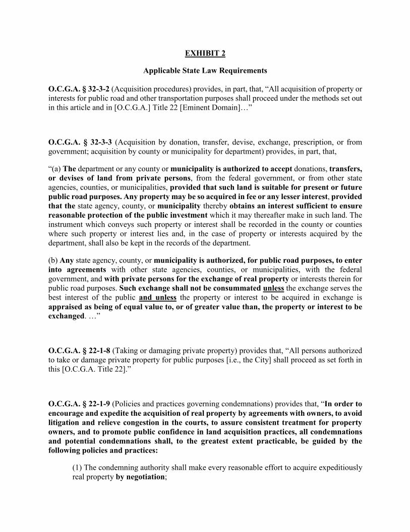
EXHIBIT 2
Applicable State Law Requirements O.C.G.A. § 32-3-2 (Acquisition procedures) provides, in part, that, “All acquisition of property or interests for public road and other transportation purposes shall proceed under the methods set out in this article and in [O.C.G.A.] Title 22 [Eminent Domain]…”
O.C.G.A. § 32-3-3 (Acquisition by donation, transfer, devise, exchange, prescription, or from government; acquisition by county or municipality for department) provides, in part, that,
“(a) The department or any county or municipality is authorized to accept donations, transfers, or devises of land from private persons, from the federal government, or from other state agencies, counties, or municipalities, provided that such land is suitable for present or future public road purposes. Any property may be so acquired in fee or any lesser interest, provided that the state agency, county, or municipality thereby obtains an interest sufficient to ensure reasonable protection of the public investment which it may thereafter make in such land. The instrument which conveys such property or interest shall be recorded in the county or counties where such property or interest lies and, in the case of property or interests acquired by the department, shall also be kept in the records of the department.
(b) Any state agency, county, or municipality is authorized, for public road purposes, to enter into agreements with other state agencies, counties, or municipalities, with the federal government, and with private persons for the exchange of real property or interests therein for public road purposes. Such exchange shall not be consummated unless the exchange serves the best interest of the public and unless the property or interest to be acquired in exchange is appraised as being of equal value to, or of greater value than, the property or interest to be exchanged. …”
O.C.G.A. § 22-1-8 (Taking or damaging private property) provides that, “All persons authorized to take or damage private property for public purposes [i.e., the City] shall proceed as set forth in this [O.C.G.A. Title 22].”
O.C.G.A. § 22-1-9 (Policies and practices governing condemnations) provides that, “In order to encourage and expedite the acquisition of real property by agreements with owners, to avoid litigation and relieve congestion in the courts, to assure consistent treatment for property owners, and to promote public confidence in land acquisition practices, all condemnations and potential condemnations shall, to the greatest extent practicable, be guided by the following policies and practices:
(1) The condemning authority shall make every reasonable effort to acquire expeditiously real property by negotiation;

(2) Where the condemning authority seeks to obtain a fee simple interest in real property, real property shall be appraised before the initiation of negotiations, and the owner or his or her designated representatives shall be given an opportunity to accompany the appraiser during his or her inspection of the property, except that the condemning authority may, by law, rule, regulation, or ordinance, prescribe a procedure to waive the appraisal in cases involving the acquisition by sale or donation of property with a low fair market value0F
1;
(3) Before the initiation of negotiations for fee simple interest for real property, the condemning authority shall establish an amount which it believes to be just compensation and shall make a prompt offer to acquire the property for the full amount so established. In no event shall such amount be less than the condemning authority’s independent appraisal of the fair market value of such property. The condemning authority shall provide the owner of real property to be acquired with a written statement of, and summary of the basis for, the amount it established as just compensation. Where appropriate, the just compensation for the real property acquired and for damages to remaining real property shall be separately stated. The condemning authority shall consider alternative sites suggested by the owner of the property as part of the compensation offered;
(4) No owner shall be required to surrender possession of real property before the condemning authority pays the agreed purchase price or deposits with the court in accordance with this title, for the benefit of the owner, an amount not less than the condemning authority’s appraisal of the fair market value of such property or the amount of the award of compensation in the condemnation proceeding for such property;
(5) The construction or development of a project for public use shall be so scheduled that, to the greatest extent practicable, no person lawfully occupying real property shall be required to move from a dwelling or to move his or her business or farm operation without at least 90 days’ written notice from the condemning authority of the date by which such move is required;
(6) If the condemning authority permits an owner or tenant to occupy the real property acquired on a rental basis for a short term or for a period subject to termination by the
1 For example, GDOT policies provide for three primary valuation options: (1) Negotiation based upon an Approved Appraisal – The Negotiator will be provided an Appraisal and a Review Appraiser release of the Appraisal (commonly called a 532). The released Fair Market Value amount will be the offer amount. There are various types of offers, depending on the ownership rights involved; (2) Negotiations based on an Approved Cost Estimate value – Non-complicated parcels with a value of $15,000 or less, and that do not involve damages may be acquired without a written appraisal using this method. This method of negotiation is used as a time saver in property acquisition, since a written appraisal is not required. However, should a settlement not be reached, an appraisal will be required for condemnation; and (3) Negotiations based on an Approved Range of Value from a Data Book – Noncomplicated parcels with a value of $25,000 or less and that do not involve damages may be acquired without a written appraisal provided that the owner elects to “negotiate for services” (NFS) and waives the right of an appraisal. This method of negotiation can also be used as a time saver in property acquisition since a written appraisal is not required. The ‘Estimate of Appraisal Calculation’ form is used to determine the value to be offered based upon an established Data Book Value Range, previously approved by the Review Appraiser. Similar to a Cost Estimate Value, if negotiations are not successful, an appraisal will be required for condemnation. See GDOT Right-of-Way Policies and Procedures, Ch. 5: Acquisition (emphasis added).

condemning authority on short notice, the amount of rent required shall not exceed the fair rental value of the property to a short-term occupier;
(7) In no event shall the condemnor act in bad faith in order to compel an agreement on the price to be paid for the property;
(8) If any legal interest in real property is to be acquired by exercise of the power of eminent domain, the condemning authority shall institute formal condemnation proceedings. No condemnor shall intentionally make it necessary for an owner to institute legal proceedings to prove the fact of the taking of his or her real property; and
(9) A person whose real property is being acquired in accordance with this title may, after the person has been fully informed of his or her right to receive just compensation for such property, donate such property, any part thereof, any legal interest therein, or any compensation paid to a condemning authority, as such person shall determine.”
O.C.G.A. § 36-33-5. Demand prerequisite to suit for injury to person or property; suspension of limitations; amount of monetary damages; service of claim (a) No person, firm, or corporation having a claim for money damages against any municipal
corporation on account of injuries to person or property shall bring any action against the municipal corporation for such injuries, without first giving notice as provided in this Code section.
(b) Within six months of the happening of the event upon which a claim against a municipal corporation is predicated, the person, firm, or corporation having the claim shall present the claim in writing to the governing authority of the municipal corporation for adjustment, stating the time, place, and extent of the injury, as nearly as practicable, and the negligence which caused the injury. No action shall be entertained by the courts against the municipal corporation until the cause of action therein has first been presented to the governing authority for adjustment.
(c) Upon the presentation of such claim, the governing authority shall consider and act upon the claim within 30 days from the presentation; and the action of the governing authority, unless it results in the settlement thereof, shall in no sense be a bar to an action therefor in the courts.
(d) The running of the statute of limitations shall be suspended during the time that the demand for payment is pending before such authorities without action on their part.
(e) The description of the extent of the injury required in subsection (b) of this Code section shall include the specific amount of monetary damages being sought from the municipal corporation. The amount of monetary damages set forth in such claim shall constitute an offer of compromise. In the event such claim is not settled by the municipal corporation and the claimant litigates such claim, the amount of monetary damage set forth in such claim shall not be binding on the claimant.

(f) A claim submitted under this Code section shall be served upon the mayor or the chairperson of the city council or city commission, as the case may be, by delivering the claim to such official personally or by certified mail or statutory overnight delivery.
O.C.G.A. § 36-37-6 (Sale of municipal property) provides, in part, that, “(a)(1) Except as otherwise provided in subsections (b) through (j) of this Code section, the governing authority of any municipal corporation disposing of any real or personal property of such municipal corporation shall make all such sales to the highest responsible bidder, either by sealed bids or by auction after due notice has been given. …
(c) Nothing in this Code section shall prevent a municipal corporation from trading or exchanging real property belonging to the municipal corporation for other real property where the property so acquired by exchange shall be of equal or greater value than the property previously belonging to the municipal corporation; provided, however, that within six weeks preceding the closing of any such proposed exchange of real property, a notice of the proposed exchange of real property shall be published in the official organ of the municipal corporation once a week for four weeks. The value of both the property belonging to the municipal corporation and that to be acquired through the exchange shall be determined by appraisals and the value so determined shall be approved by the proper authorities of said municipal corporation. …”