velindre cancer centre environmental statement vol.1
TRANSCRIPT

Velindre Cancer Centre Environmental Statement Vol.1: Environmental Statement Text
Chapter 4: Development Description
Draft - March 2017
Prepared by: Mott McDonald, The Urbanists and HLMAddress: The Urbanists, The Creative Quarter, 8A Morgan Arcade, Cardiff, CF10 1AF, United KingdomEmail: [email protected] / [email protected]: www.theurbanists.net
All plans within this document are reproduced from Ordnance Survey with permission of the controller of Her Majesty’s Stationary Office (C) Crown copyright. Unauthorised reproduction infringes Crown copyright and may lead to prosecution/civil proceedings. Licence No 100054593.
Issue date March 2017 -
Drawing status DRAFT -
Revision 2 -
Author MF / LH -
Checked by MF / LH -

CHAPTER 4
DEVELOPMENT DESCRIPTION


CHAPTER 4 DEVELOPMENT DESCRIPTION
Velindre NHS Trust Velindre Cancer Centre
TABLE OF CONTENTS PAGE
4.1 INTRODUCTION 4:1
4.2 DEVELOPMENT COMPONENTS 4:1
4.3 ACCESS ROUTES 4:3
4.4 PARKING 4:5
4.5 DRAINAGE 4:5
4.6 LIGHTING 4:6
4.7 LANDSCAPE 4:6
4.8 OPERATIONAL PHASE 4:7
4.9 CONSTRUCTION PHASE 4:7
4.10 DEVELOPMENT DESIGN 4:11


CHAPTER 4 DEVELOPMENT DESCRIPTION
Velindre NHS Trust Velindre Cancer Centre
Page 4:1
4 DEVELOPMENT DESCRIPTION
4.1 Introduction
4.1.1 This chapter describes the proposed development that has been assessed in the EIA. It identifies the individual development components, provides a schedule of the construction activities that would be required, and details how the development would operate. The second part of the chapter explains why the development is proposed in the form described and identifies how environmental matters have shaped the proposed design. The development described in this chapter is illustrated in the chapter 4 figures.
4.1.2 The background to the considered options for the development, and the service provision model, leading to this proposal, is set out in Chapter 5. This sets out the form of the proposed clinical service model and the overall components of it. The elements of this which form the development scheme for the application site are: the new Velindre Specialist Cancer Centre, Velindre Cancer Research Institute, and a Velindre Village@ facility (local care services). These elements are described below.
4.2 Development Components
4.2.1 The proposed development consists of a new Velindre Cancer Centre and associated infrastructure that includes two vehicle access routes, internal pedestrian routes, a new pedestrian access, a pedestrian and cycle connection to Coryton Railway Station, vehicle parking, internal pedestrian routes, drainage infrastructure, an energy centre, utilities and services, public realm and landscape works. A new Maggie’s Centre is also proposed. Each of these components is described below.
Velindre Specialist Cancer Centre 4.2.2 Cancer survival rates are increasing, but the number of people getting cancer is increasing too.
Velindre NHS Trust has known for some time that these facts mean that, without change, Velindre Cancer Centre would increasingly struggle to meet forecasted levels of demand, whilst continuing to deliver the highest level of care, quality and patient experience. The new Velindre Cancer Centre is at the centre of the effort to transform cancer care services in South East Wales and ensure that patients benefit from the highest level of care, quality and patient experience. The new facility will be supported by outreach facilities that will be delivered within the local communities of South East Wales to improve access to key cancer treatment services. These outreach facilities are not considered in this Environmental Statement.
4.2.3 The new Velindre Cancer Centre will comprise a maximum 40,000 sq.m of gross internal floor area for Cancer health services (planning use classes: C2 Residential Institutions, and D1 Non-residential institutions). No surgical treatment will be undertaken at the centre, but space for the delivery of the following critical services will be provided: radiotherapy; chemotherapy; pharmacy; inpatient beds; outpatients services; support services; and imaging. A conference centre facility will also be provided. The new centre will be designed with the needs of the patient at its core, reinforcing the reputation of the current Velindre Hospital as a centre of excellence for cancer treatment.
4.2.4 A Centre for Learning, Research and Development forms an integral part of the proposal. The new Centre will also aim to make Velindre an international focal point for research & development with an

CHAPTER 4 DEVELOPMENT DESCRIPTION
Page 4:2
emphasis on expanding clinical trials and improving the translational research links between 'bench' and ‘bed'.
4.2.5 A key design feature of the centre will be the provision of a patient hub at the centre of the new facility. The patient hub will be the main destination for patients and visitors to the centre, providing facilities that will enable patients to orientate themselves, register for appointments, wait for treatments and consultations and access key amenity facilities (including multi-faith facilities a cafe and restaurant). The waiting areas within the hub will provide a tranquil environment for patients to ensure that the patient experience is as positive as possible. The key services identified above, will be accessed from the hub and will be located within a series of building ‘arms’ or ‘wings’ that will all be interconnected to ensure circulation. Refer to Chapter 4 Figures for the building layout.
4.2.6 The building will be between two and three storeys. The maximum parameters of the centre are identified in the table below. The parameters plan included in the chapter 4 figures demonstrates the application of the height range.
Table 4.1: Maximum building parameters of the Velindre Cancer Centre
Height Width Length
4.5m-19m 100m-150m 180m-220m
4.2.7 Landscape will be integrated into the building surrounds so that a green environment is created for
patients and staff. The landscape design will be informed by the site’s existing landscape and ecological character. Further details on the landscape strategy are provided below.
4.2.8 A service yard will be located adjacent to the cancer centre. All delivery vehicles to the site will enter this space. The yard will be accessible from the main internal site road and will be approximately 25m in width and 60m in length.
Energy Centre 4.2.9 An Energy Centre would be provided on the site to provide a base load to the new Velindre Cancer
Centre. The energy centre would be located away from the main centre in the northwest corner of the site. The Energy Centre would consist of gas fired (CHP) boilers that would also have the potential to run on oil. Diesel generators would also be provided in the energy centre to be used only as emergency back up. The total output from the Energy Centre would be 2MWp. The minimum and maximum building parameters are identified in the table below and illustrated in the parameters plan.
Table 4.2: Maximum building parameters of the Energy Centre
Height Width Length
Main Building 5m-10m 12m-18m 15m-23m
Flue 19m-24m
CHAPTER 4 DEVELOPMENT DESCRIPTION
Velindre NHS Trust Velindre Cancer Centre
Page 4:3
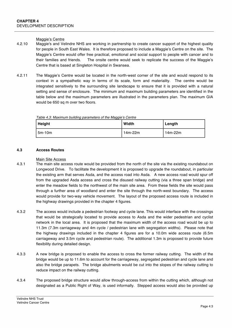
Maggie’s Centre
4.2.10 Maggie's and Velindre NHS are working in partnership to create cancer support of the highest quality for people in South East Wales. It is therefore proposed to include a Maggie’s Centre on the site. The Maggie’s Centre would offer free practical, emotional and social support to people with cancer and to their families and friends. The onsite centre would seek to replicate the success of the Maggie’s Centre that is based at Singleton Hospital in Swansea.
4.2.11 The Maggie’s Centre would be located in the north-west corner of the site and would respond to its context in a sympathetic way in terms of its scale, form and materiality. The centre would be integrated sensitively to the surrounding site landscape to ensure that it is provided with a natural setting and sense of enclosure. The minimum and maximum building parameters are identified in the table below and the maximum parameters are illustrated in the parameters plan. The maximum GIA would be 650 sq m over two floors.
Table 4.3: Maximum building parameters of the Maggie’s Centre
Height Width Length
5m-10m 14m-22m 14m-22m
4.3 Access Routes
Main Site Access 4.3.1 The main site access route would be provided from the north of the site via the existing roundabout on
Longwood Drive. To facilitate the development it is proposed to upgrade the roundabout, in particular the existing arm that serves Asda, and the access road into Asda. A new access road would spur off from the upgraded Asda access and cross the disused railway cutting (via a three span bridge) and enter the meadow fields to the northwest of the main site area. From these fields the site would pass through a further area of woodland and enter the site through the north-west boundary. The access would provide for two-way vehicle movement. The layout of the proposed access route is included in the highway drawings provided in the chapter 4 figures.
4.3.2 The access would include a pedestrian footway and cycle lane. This would interface with the crossings that would be strategically located to provide access to Asda and the wider pedestrian and cyclist network in the local area. It is proposed that the maximum width of the access road would be up to 11.3m (7.3m carriageway and 4m cycle / pedestrian lane with segregation widths). Please note that the highway drawings included in the chapter 4 figures are for a 10.0m wide access route (6.5m carriageway and 3.5m cycle and pedestrian route). The additional 1.3m is proposed to provide future flexibility during detailed design.
4.3.3 A new bridge is proposed to enable the access to cross the former railway cutting. The width of the bridge would be up to 11.6m to account for the carriageway, segregated pedestrian and cycle lane and also the bridge parapets. The bridge abutments would be cut into the slopes of the railway cutting to reduce impact on the railway cutting.
4.3.4 The proposed bridge structure would allow through-access from within the cutting which, although not designated as a Public Right of Way, is used informally. Stepped access would also be provided up

CHAPTER 4 DEVELOPMENT DESCRIPTION
Page 4:4
the embankment on both sides of the cutting for pedestrians. The stepped access would interface with the pedestrian and cycle lane and crossing points included on the access. The stepped access would replicate existing arrangements in the cutting and would not comply with the requirements of the Disability and Discrimination Act due to the steepness of the cutting slopes.
4.3.5 When the access enters the northern meadow, a 2m-grass verge would be provided to the north of the main carriageway. This verge would continue when the route enters into the main site area.
4.3.6 In the northern meadow there is steep cross fall The access route would therefore utilise embankments in part, but also cutting (up to 3m) as it approaches the main site boundary, since there is localised mounding in this area. Where embankments are used they would be planted with a wild seed grass mix, which would be appropriately maintained and managed along with the wider meadow in accordance with a management plan.
4.3.7 Once in the main site area the highway would pass through the site past the proposed decked parking area to the new Velindre Cancer Centre. It is intended that the highway splits into two close to the buildings: one part would provide access to a drop-off area and the undercroft parking area; and the other would follow around to the north of the new buildings to connect with the emergency access (refer below) and the service yard. Parts of the route inside the main site area would be at grade, but some sections would be below grade (up to 5m) to ensure suitable access to the service yard.
Emergency Access 4.3.8 An emergency access would be delivered through the site’s north-eastern boundary via the Hollybush
Estate. The access would be created from the existing highway network that dissects Sycamore House and Poplar House in the south of the estate and enter the site by passing through the woodland and the former railway cutting (including the surrounding woodland). As it enters the site, the access would join with the main site access road as described above. The carriageway of the emergency access would be up 5.5m wide. The access road would again be bridged to cross the railway cutting. The total width of the bridge would be up to 7.6m (6.7m for the carriageway and verges and 0.9m for the bridge parapets). The access would be closed to vehicles except for a very rare event of a major emergency and would therefore be gated to prevent uncontrolled use by vehicles and pedestrians. The structure and width would, however, allow it to be used as a bus exit if this became necessary in the future. The layout of the proposed route is included in the highway drawings provided in Chapter 4 figures.
Pedestrian Access 4.3.9 An adopted highway currently follows the south-east boundary of the main site area from the main
highway (A4094) to connect with the public path which follows outside the south-western boundary of the main site. This route formally remains as adopted highway (despite being mostly overgrown) and currently provides access to the main site area at the meeting of the north-east boundary and south-east boundary. It is proposed to use this route as a pedestrian and cycle access to the site. To ensure that this route is fit for purpose it is proposed to resurface the route using an asphalt surface and provide sufficient levels of lighting. Works would also include the refurbishment of the footpath that links Park Road to the site via the existing arched bridge adjacent to the Hollybush Estate. When the route enters the site it would connect to the main site access and the pedestrian routes that interface with it and the footpath network that surrounds the site. A new pedestrian route is also proposed between the site and Coryton Railway Station, subject to the redevelopment works at Coryton Station and the potential Metro project to reopen the railway cutting to rail movement. The
CHAPTER 4 DEVELOPMENT DESCRIPTION
Velindre NHS Trust Velindre Cancer Centre
Page 4:5
route would be provided from the station to the site via the railway cutting under the existing Park Road overbridge. This route would again be surfaced and provided with suitable lighting. The proposed alignment of these routes is included in the highway drawings provided in the Chapter 4 figures.
Internal Pedestrian Routes 4.3.10 A series of internal pedestrian routes would be provided within the site to connect the parking areas,
the Velindre Cancer Centre, the Maggie’s Centre and the Energy Centre. The routes would also interface with the footpath network described in the previous chapter to ensure that walkers are able to pass through the site as they currently do. Where possible the routes would replicate the existing prominent pathways. The finish of the footpaths would vary. Routes connecting the key main development components would be designed to professional standards, while the routes connecting to pedestrian routes surrounding the site would be more natural in appearance reflect the existing character of the routes.
4.4 Parking
4.4.1 A total of 879 parking spaces are required by the development to accommodate staff and patients. 500 of these spaces would be provided beneath the Velindre Cancer Centre in undercroft and underground parking.
4.4.2 367 spaces would be provided in a two storey decked parking area, that would be accessible from the main site access. The decked parking area would be located adjacent to the Velindre Cancer Centre. The decked area would respond to the existing site topography so that both levels can be accessed at surface level. The minimum and maximum parameters of the decked parking area are identified in the table below and illustrated in the parameters plan.
Table 4.4: Minimum and maximum building parameters of the decked car park
Height Width Length
4m-5m 40m-50m 70m-80m
4.4.3 The remaining 12 parking spaces would be provided as surface parking at the Maggie’s Centre. A breakdown of parking requirements is provided further below.
4.5 Drainage
4.5.1 The surface water drainage strategy for the main site area would rely on discharge to a 300mm diameter Dŵr Cymru Welsh Water (DCWW) surface water sewer, which is located on the site’s south-east boundary. Flows into this sewer would be controlled to Greenfield run off rates. This arrangement has been confirmed with DCWW, but applies to surface water run off only and excludes land drainage. This prevents open and ground level SuDS features such as swales, ponds and detention basins, on the basis that land drainage could enter the surface water sewer via these features. It is therefore necessary for the surface water sewer to consist of road gullies with carrier drains that connect to a closed buried cellular attenuation system with a vortex flow control to limit the flows. The cellular attenuation would include a permeable base to allow some infiltration into the ground when conditions allow.

CHAPTER 4 DEVELOPMENT DESCRIPTION
Page 4:6
4.5.2 The following features would be incorporated into the design of the main site building as part of the surface water strategy: incorporation of green roofs; provision of bio-retention planters to collect from the building roof water downpipes (planters would be situated on a structural slab over the basement car park); and, provision of tree pits within the building’s central area to take flows from the rainwater downpipes (overflows would connect to the surface water drainage network. Bio-retention planters would also be proposed adjacent to the decked parking area. The planters would be above ground and would not take land drainage.
4.5.3 Due to the site topography a separate surface water drainage strategy is required for the main site access north of the energy centre and the Maggie’s Centre. As with the main development area the strategy would rely on discharge from the low point in the road (this is just before the road would enter the main site area) to a 525mm diameter surface water sewer located in the disused railway cutting. The flows to this sewer would be minimal given the small run off area of the road. Again, due to the exclusion of land drainage required by DCWW, it would be necessary to use road gullies; carrier drains and a cellular storage tank with vortex control. The base of the attenuation tank would again be permeable to use some infiltration when conditions allow. Levels for the connection would be confirmed by DCWW as part of the detailed design process.
4.5.4 The development’s foul water would drain to a 150mm diameter combined DCWW sewer, which is located under the footpath which leads from the site down to the Glamorganshire Canal. This arrangement has been confirmed with DCWW. Although the levels for this sewer have not been collected, due to the steep nature of the pathway it is likely the inverse is sufficiently low to allow a gravity connection from the site. A pumping station is therefore not proposed. DCWW would confirm the levels of the sewer as part of the detailed design process. However, if required the pumping station would not be large and could be buried to reduce visual impact.
4.5.5 The drainage strategy is described and illustrated in the strategic drainage strategy plan and document that are included in the planning application.
4.6 Lighting
4.6.1 Lighting design for the site is not yet developed at this outline stage. The site lies on the edge of a residential area and could be categorised as suburban (Environmental Zone E3). However, parts of the site could be considered as rural (Environmental Zone E2). To account for this, the lighting design on the site would be designed to ensure that the proposed development accords with the obtrusive lighting limitations of a rural area (Zone E2). Specific measures that could be incorporated into the design would include reducing the height and tilt of luminaires; avoiding use of mounted columns on the main access bridge; applying baffles, shields or louvres; utilising luminaires with low ultraviolet light output; and, incorporating dimming technology to be used at times of decreased use. These measures are further detailed in the lighting assessment included in the planning application.
4.7 Landscape
4.7.1 The purpose of the landscape strategy is to retain as much of the site’s landscape and ecological character as possible and to also provide the Velindre Cancer Centre and its patients with a high quality and tranquil environment. The landscape strategy is included in the chapter 4 figures.
4.7.2 The site landscape strategy would be ecology led, and a key element of the strategy would be to retain and restore as much of the existing grassland habitat (where possible) that characterises the site and

CHAPTER 4 DEVELOPMENT DESCRIPTION
Velindre NHS Trust Velindre Cancer Centre
Page 4:7
to provide wildflower planting to enhance biodiversity of the landscaped areas. Areas of grassland would be incorporated into the surrounds of the building, and into the parking areas and pedestrian footpaths, and also be used to screen embankments of the access road and parking areas.
4.7.3 Appropriate tree planting would be applied alongside the grassland to create outdoor ‘pocket’ spaces and screen views of essential development infrastructure. Trees would be large in scale. Where trees need to be removed to facilitate the main site access and emergency access, appropriate replacement tree planting would be undertaken to prevent gaps in the tree canopy exceeding 10m and maintain bat flight continuity.
4.7.4 On the outskirts of the site, the emphasis would be on better management of the scrub that frames the site. Along the south-western boundary where the informal pedestrian route and Public Right of Way is located, the scrub would be managed and enhanced to provide a screened and defined route for pedestrians to pass through the site.
4.7.5 The development layout would incorporate a 10-15m buffer along the south-west boundary adjacent to the Site of Special Scientific Interest (SSSI). The 10-15m zone would include the existing Public Right of Way and non-statutory footpaths and would be subject to landscape enhancement described above. No building development would be undertaken in this zone.
4.7.6 Invasive species, including Himalayan Balsam, are located on the fringes of the site and in the surrounding area (including the SSSI). It is proposed to treat and remove this as part of the development proposals.
4.8 Construction Phase
Construction Schedule 4.8.1 A construction programme has not yet been defined in detail for the development. However, it is
assumed that the construction would be phased so that key enabling works (consisting of the provision of statutory services and the main access roads) would be undertaken first for completion in 2019. The key activities to be undertaken during this period would be: compound delivery and roundabout upgrade; upgrade of the highway adjacent to the Asda supermarket and rework of parts of Longwood Drive; construction of the northern access bridge; and, construction of the access road through the meadow to the north of the main site area. The development of the main site area (the provision of the new Cancer Centre, the Maggie’s Centre, the Energy Centre, parking and internal access routes), the emergency access and the pedestrian routes would be undertaken between 2019 and 2022.
4.8.2 When the highway bridge is under construction, the main site compound would be located on part of the supermarket car park. Following the completion of the highway bridge, the compound would be moved into the main site area. During the construction of the highway bridge it would also be necessary for a smaller compound to be provided in the former railway cutting.
Construction Vehicle Routes 4.8.3 Construction vehicles (plant and construction personnel) for the main building works would enter the
site via the main site access from the north. However, in order to build the main access bridge element, and also the bridge element of the secondary access, temporary construction access routes would be required. In total, two temporary construction routes are proposed. The first would be via the existing Whitchurch Hospital site from the existing highway infrastructure. The second would be from Park Road via the unused triangular parcel of land and the cutting. These routes would be in

CHAPTER 4 DEVELOPMENT DESCRIPTION
Page 4:8
place for approximately 6-9-months, and the volume of vehicles utilising them would be minimal (refer below).
4.8.4 The works to facilitate these routes would be minimal. To deliver the first route, part of the scrub (north of the George Thomas Hospice) would be removed (including the Japanese Knotweed located in this area which would be removed under a Japanese Knotweed management plan), and a temporary surface would be laid. Trees with a Tree Preservation Order are located in this area, but are unlikely to be impacted by the temporary works. To deliver the second route, it would be necessary to undertake some scrub clearance at the entrance and create a stone turning area in the above mentioned triangular land parcel off Park Road. No works would be required to the former railway cutting, but it might be necessary remove overhanging branches and dead trees. All vegetation clearance would either be completed outside of breeding bird season, or under ecological supervision. Where vegetation is cleared to facilitate the routes it would be reinstated (N.B. the exact type and density of replacement planting would be agreed with the landowners).
Number of Construction Vehicles 4.8.5 The exact number of construction vehicles is not known at this stage. However, based on similar
developments it is expected that an annual average daily figure of 100 HGV deliveries is likely (200 two way movements), with some occasional days where this number would be marginally exceeded. Based on a typical 10-hour working day this would equate to 20 HGV movements an hour. All HGV would be routed via the A470 and M4 J32, not via Park Lane / Pendywallt road (all suppliers to be provided with copies of appropriate route maps) to minimise impact on surrounding road network.
4.8.6 The numbers of construction personnel are also not yet known, but at the height of the development of the main site area, it is anticipated that there would be no more than 500 construction personnel on site. It is also anticipated that the chosen contractor would provide transport into the site for construction workers.
4.8.7 The number of vehicles accessing the temporary routes required to build the access bridges would be minimal as plant would remain in compounds on site and delivery numbers would be low. It is expected that when bridge works initially commence there would be 10-20 HGV deliveries per day and then 2-3 deliveries per day thereafter. Where large vehicles (like piling rigs) need to access the cutting at the outset of the bridge construction period, their access would be undertaken in accord with a traffic management scheme that would be agreed with Cardiff City Council prior to the commencement of works.
Construction Activities 4.8.8 A schedule of construction activities is not yet defined. This would be provided as part of the
construction programme created by the chosen contractor. However, it is considered likely that the following construction activities would be undertaken on site:

CHAPTER 4 DEVELOPMENT DESCRIPTION
Velindre NHS Trust Velindre Cancer Centre
Page 4:9
Table 4.5: Schedule of construction activities.
Earthworks & Landscaping Infrastructure Buildings
Construction of haul routes Erection of site compound on Asda car park and then the main site area
Laying foundations
Soil stripping Construction of main access road and shared footpath (including excavation; piling construction of bridge structure; laying of aggregates and final finishes; and, implementation of drainage).
Construction of ground floor slabs (including basement level to the main Cancer Centre)
Temporary stockpiling Construction of emergency access (actions as above)
Construction of site buildings (including upper floors, roof, and walls)
Excavation for essential infrastructure and buildings and parking areas
Construction of internal pedestrian access routes (including excavation; laying of aggregates and final finishes).
Implementation of bespoke building drainage
Placing, compacting and treating excavated material
Construction of decked parking area (including foundations; ground floor slab; upper floors, roof and walls; bespoke drainage; and electrical infrastructure)
Incorporation of mechanical and electrical infrastructure
Land reprofiling Construction and installation of power, water and gas infrastructure
Internal finishes and fit out
Construction of retaining retaining structures (including embankments)
Implementation of drainage infrastructure
Soft landscape works Implementation of drainage infrastructure
Construction Hours
4.8.9 Typical construction hours on the site would be 08:00-18:00 Monday to Friday and 08:00-13:00 on Saturday, although night working would be required to build the bridge deck of the main site access. Extensions beyond these hours for specific activities would be agreed with Cardiff City Council and adjacent consultees would be notified. During the pre-enabling phase, works would be minimised during Asda’s peak periods to reduce disruption. Generally, minimised work would be undertaken during the following: Christmas and Easter; bank holidays; 16:00 until 20:00 on a Thursday and a Friday, 09:00 until 21:00 on a Saturday; and, 10:00 until 16:00 on a Sunday.
CHAPTER 4 DEVELOPMENT DESCRIPTION
Page 4:10
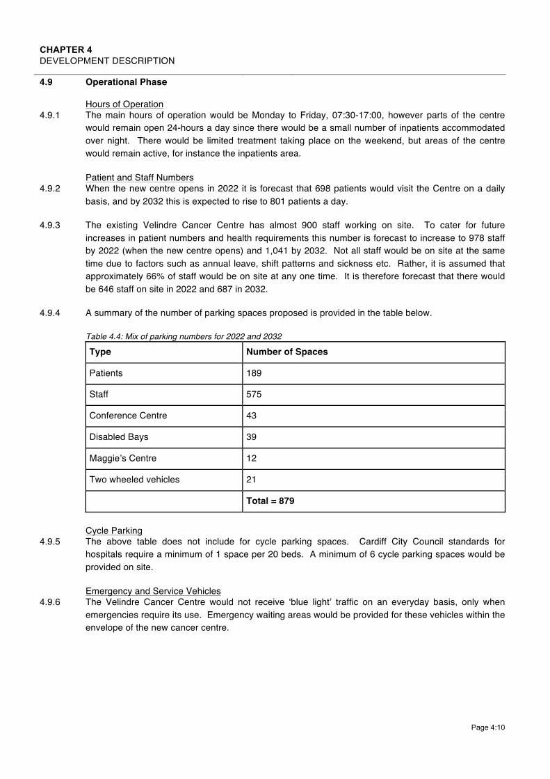
4.9 Operational Phase
Hours of Operation 4.9.1 The main hours of operation would be Monday to Friday, 07:30-17:00, however parts of the centre
would remain open 24-hours a day since there would be a small number of inpatients accommodated over night. There would be limited treatment taking place on the weekend, but areas of the centre would remain active, for instance the inpatients area.
Patient and Staff Numbers 4.9.2 When the new centre opens in 2022 it is forecast that 698 patients would visit the Centre on a daily
basis, and by 2032 this is expected to rise to 801 patients a day.
4.9.3 The existing Velindre Cancer Centre has almost 900 staff working on site. To cater for future increases in patient numbers and health requirements this number is forecast to increase to 978 staff by 2022 (when the new centre opens) and 1,041 by 2032. Not all staff would be on site at the same time due to factors such as annual leave, shift patterns and sickness etc. Rather, it is assumed that approximately 66% of staff would be on site at any one time. It is therefore forecast that there would be 646 staff on site in 2022 and 687 in 2032.
4.9.4 A summary of the number of parking spaces proposed is provided in the table below.
Table 4.4: Mix of parking numbers for 2022 and 2032
Type Number of Spaces
Patients 189
Staff 575
Conference Centre 43
Disabled Bays 39
Maggie’s Centre 12
Two wheeled vehicles 21
Total = 879
Cycle Parking
4.9.5 The above table does not include for cycle parking spaces. Cardiff City Council standards for hospitals require a minimum of 1 space per 20 beds. A minimum of 6 cycle parking spaces would be provided on site.
Emergency and Service Vehicles 4.9.6 The Velindre Cancer Centre would not receive ‘blue light’ traffic on an everyday basis, only when
emergencies require its use. Emergency waiting areas would be provided for these vehicles within the envelope of the new cancer centre.

CHAPTER 4 DEVELOPMENT DESCRIPTION
Velindre NHS Trust Velindre Cancer Centre
Page 4:11
4.10 Development Design
4.10.1 This section explains how the development identified in the previous chapter has been informed by, and evolved, to respond to environmental matters included in the EIA process and pre-planning submission process.
Velindre Cancer Centre 4.10.2 The decision to locate the building in the south of the site was taken as this is the lowest point of the
site and provides the opportunity to work with the existing site levels and reduce the Whitchurch Hospital and Coryton House, which are designated heritage features. It also prevents large-scale development being located in the north section of the site, and provides the opportunity to provide better pedestrian connections to the local highway network.
4.10.3 The approach to restricting the height of the building to a maximum of three storeys was taken because this would minimise its visibility above the site’s tree line and reduce its landscape and visual impact from the local area beyond the site.
4.10.4 The design approach of dividing the building into separate blocks was taken to further reduce the scale and mass of the building from viewpoints around the site and further minimise its impact on Whitchurch Hospital and Coryton House.
Energy Centre 4.10.5 The decision to locate the energy centre in the north-east corner of the site was taken to reduce the
visual impact of the flue, particularly from residences on Hollybush Estate and Clos Coed Hir. The closer the energy centre is to the main cancer centre, and residences, the taller the flue must be to ensure that dispersion can be undertaken without harm to human health. Given that some of the buildings on the Hollybush Estate are 10-storeys in height, the flue height would need to be significant. The proposed location is as far from residential receptors as possible on the site without being unreasonably close to ecological designations, and the height of the flue is therefore minimised.
Main Access 4.10.6 The upgrades proposed to the roundabout on Longwood Drive have been identified by the transport
modelling undertaken to identify what the transport impact of the development would be. The upgrades are therefore proposed because they would be sufficient to accommodate the additional vehicles that would use the local highway to access the new Velindre Cancer Centre.
4.10.7 The width of the carriageway has been limited (while still adhering to technical guidance) to limit the land-take of the access road and its impact on the existing site habitat.
4.10.8 The incorporation of a cycle lane onto the main access road has been undertaken through engagement with Cardiff Council to encourage active travel to and from the development.
4.10.9 The use of bridges across the former railway cutting is proposed to ensure that walkers can continue to move through the railway cutting and the Council can continue to use the cutting as a maintenance route. The through access would also ensure that DCWW can continue to access a surface water sewer that is located in the cutting for maintenance purposes. Finally, there is a possibility that the disused railway cutting could be reopened as part of the South East Wales Metro.

CHAPTER 4 DEVELOPMENT DESCRIPTION
Page 4:12
4.10.10 The proposed pedestrian access adjacent to the northern bridge would provide access into and out of the cutting and improve pedestrian connectivity between the development and the surrounding pedestrian footpath network.
4.10.11 The planting intended for the access bridge is proposed to reduce its visual impact on the railway cutting. It is also intended to reduce the impact of the bridge on bat movement through the disused railway cutting.
4.10.12 The access road has been designed to respond to the site topography. The use of embankment, cutting and at grade reflects localised topography of the site. The landscape proposals (planted embankments and tree planting) are intended to further soften and screen the appearance of the road to reduce its visual impact
4.10.13 When the EIA was commenced, two main options were considered as the main northern access route. Option one (the route through Asda which has been taken forward) and option two (a route that would provide access to the site directly through the Local Nature Reserve via a new junction on Longwood Drive). Option one was progressed because the Ecology Impact Assessment identified that option two would have a greater ecological impact on the Local Nature Reserve and its ecology than option one. The Transport Impact Assessment also identified that option two could have a greater impact on the local highway network than option one. Finally, although not included in the EIA, the Utilities Statement identified that statutory services posed a far greater constraint to the delivery of option 2, and that significant expense could be required to undertake the diversions that would be necessary to deliver option 2.
Emergency Access 4.10.14 The decision to restrict the secondary site access to an emergency access only was taken to avoid
disruption to the residences of the Hollybush Estate.
4.10.15 As with the main access, it is proposed to construct a bridge over the cutting to ensure walkers and maintenance vehicles can continue to move through the railway cutting.
4.10.16 The intention to gate the access so that it is only used by emergency vehicles in emergency situations was taken to ensure that users do not park on the Hollybush Estate and use the emergency access to walk across to the cancer centre. Should the route be utilised as a one-way bus route in the future, the gated system would ensure that pedestrians are not able to enter as a bus leaves.
4.10.17 The approach to minimising the width of the secondary access bridge to 5.5m and the width of the bridge to 7.6m is proposed to limit the land-take and its impact on the railway cutting.
4.10.18 As with the main access, the planting proposed on the bridge is proposed to reduce its landscape and visual impact and its impact on bat movement.
Construction Access 4.10.19 The southern construction access routes required to build the bridges of the permanent access routes
were chosen because they can be delivered with minimal environmental impact. The alternative would have been to construct a construction access the site from the north (directly from Longwood Drive or via the existing arched bridge located behind McDonalds); which would have been more environmentally intrusive in terms of loss of tree planting and site habitat. The access from Longwood Drive would also have passed through the north-east section of the SSSI.

CHAPTER 4 DEVELOPMENT DESCRIPTION
Velindre NHS Trust Velindre Cancer Centre
Page 4:13
Pedestrian Access 4.10.20 The approach to utilising the adopted highway that enters the site in the north-west corner, as a
pedestrian and cycle route into the site, was taken as the route is already an established point of access into the site from the wider public highway network; has good connections to bus-stops on the local highway and Coryton Railway Station; and, provides the opportunity to create a new pedestrian and cycling access to Coryton Railway Station with minimal environmental impact.
4.10.21 The new pedestrian route from Coryton Railway Station is proposed because it would improve connectivity between the site and Coryton Railway Station and arrival to the development by public transport. If the route was not delivered connectivity between the site and Coryton Station would be reduced by the significant level change between Coryton Station and Park Road.
Internal Access 4.10.22 The decision to incorporate the adopted highway and adjacent public rights of way into the
development layout was taken to minimise the development’s impact on the footpath network located in the site and surrounding area.
4.10.23 The location of the internal access routes and the incorporation of ‘natural paths’ are proposed to replicate the informal pedestrian routes that currently exist on the site as far as possible.
Parking 4.10.24 The total number of car parking spaces is proposed to ensure that there is sufficient parking on site
and the parking issues that currently afflict the local area surrounding the existing Velindre Cancer Centre are not repeated here.
4.10.25 Undercroft and underground parking levels are proposed to limit the amount of land required for parking on the site and to maximise opportunities for the retention / incorporation of grassland into the development layout.
4.10.26 The decision to deliver a decked parking area was again taken to limit the land-take required for parking and increase the opportunity to deliver ecological enhancement.
4.10.27 The decision to restrict the parking to two decks as opposed to delivering a multi-storey was taken to reduce its landscape and visual impact and also ensure that that it appears subservient in form to the main cancer centre.
Drainage 4.10.28 The form of the drainage strategy is proposed because the site’s ground conditions make the provision
of soakaways unviable, and connecting to a watercourse would require drainage infrastructure to be delivered through the SSSI, which would increase the development’s ecological impact.
4.10.29 The limited presence of open and ground level SUDS features in the surface water strategy (such as swales, ponds and detention basins) is required to satisfy DCWW, which would not permit land drainage to enter its surface water sewers located adjacent to the site.
Lighting 4.10.30 The adoption of rural site setting (Environmental Zone E2) obtrusive light limitations for the entirety of
the site has been undertaken as a conservative approach to ensure that the lighting design minimises light and impact on adjacent ecological designations and key species like bats).

CHAPTER 4 DEVELOPMENT DESCRIPTION
Page 4:14
Landscape 4.10.31 The decision to incorporate a 15 metre buffer into the site layout was taken to prevent the
development having a direct impact on the SSSI and minimise its impact on the setting of the SSSI.
4.10.32 The decision to prioritise grassland in the site landscape strategy over tree planting was taken as the site is designated as a SINC for its grassland habitat and the retention / incorporation of grassland into the development layout would minimise the development’s ecological impact and ensure that opportunities to deliver onsite compensations is maximised.
4.10.33 The proposal to enhance the scrub on the fringes of the site is proposed to deliver ecological enhancement and in the case of the southwest boundary provide a screened corridor for local walkers to pass through.
4.10.34 Appropriate replacement tree-planting is proposed on the fringes of the site to provide replacement tree planting for the trees that would be lost in order to deliver the main and emergency site access routes.
4.10.35 It is proposed to treat and remove the Japanese Knotweed on the fringes of the site and SSSI to improve the ecological and landscape character of the site and surrounding area.
