vegetation health monitoring and management plan · vegetation health monitoring and management...
TRANSCRIPT

Plan
Vegetation Health Monitoring
and Management Plan
Eliwana
June 2018
EW-PL-EN-0003

Vegetation Health Monitoring and Management Plan Page 2 of 43
EW-PL-EN-0003
This document is protected by copyright, no part of this document may be reproduced or adapted without the consent of the originator/company owner, all rights are reserved. This document is “uncontrolled when printed”, refer to signed electronic copy for up to date version.
Vegetation Health Monitoring and Management Plan
Document_Revision Number
EW-PL-EN-0003
13/06/2018
Status DRAFT
Summary of
Changes
Author O. Hertsted
Signature
13/06/2018
Checked or
Squad Review# (if applicable)
First Name Surname Here
Signature
Click here to enter a date.
Approved First Name Surname Here or FMG-SQ#
Signature
Click here to enter a date.
Access to this document:
Choose an item. Next Review Date (if applicable)
Click here to enter a date.
Revision History (to be completed for each version retained by Document Control)
Author Checker Approver Rev No.
Status Issued Date
Initial/Surname Initial/Surname Initial/Surname Choose an item.
Click here to enter a date.
Initial/Surname Initial/Surname Initial/Surname Choose an item.
Click here to enter a date.

Vegetation Health Monitoring and Management Plan Page 3 of 43
EW-PL-EN-0003
Report
TABLE OF CONTENTS
ACRONYMS .............................................................................................................................. 7
1. INTRODUCTION ............................................................................................................ 8
1.1 Requirement for the Management Plan ............................................................ 8
1.2 Objective and Scope ......................................................................................... 8
1.3 Key environmental values ................................................................................. 9
1.4 Definitions ........................................................................................................ 12
1.4.1 Conservation Significant Flora Species and Vegetation ....................... 12
1.5 Legislation and Regulatory Framework ......................................................... 14
2. ROLES AND RESPONSIBILITIES ............................................................................... 15
3. ENVIRONMENTAL MANAGEMENT ............................................................................ 16
3.1 Managing Environmental Risk ........................................................................ 16
4. MONITORING GUIDELINES ........................................................................................ 22
4.1 Objectives ........................................................................................................ 22
4.2 Baseline Survey ............................................................................................... 22
4.3 Program Summary........................................................................................... 23
4.4 Monitoring parameters and methods ............................................................. 23
4.4.1 Vegetation Condition and Health .......................................................... 24
4.4.2 Erosion patterns ................................................................................... 26
4.4.3 Multi-Spectral Imagery ......................................................................... 27
4.4.4 Monitoring Program Review ................................................................. 31
4.4.5 Data handling and Statistical Analysis .................................................. 31
4.5 Contingency Actions ....................................................................................... 32
5. COMPLIANCE .............................................................................................................. 34
6. REPORTING ................................................................................................................ 35
6.1 Annual Monitoring Report ............................................................................... 35
6.2 Annual Compliance Assessment Report ....................................................... 35

Vegetation Health Monitoring and Management Plan Page 4 of 43
EW-PL-EN-0003
Report 6.3 Reporting of Potential Non-Compliances ...................................................... 35
7. ADAPTIVE MANAGEMENT ......................................................................................... 37
8. REVIEW OF THE PLAN ............................................................................................... 38
9. STAKEHOLDER CONSULTATION .............................................................................. 39
10. REFERENCES ............................................................................................................. 40

Vegetation Health Monitoring and Management Plan Page 5 of 43
EW-PL-EN-0003
Report List of Tables
Table 1: Acronyms ...................................................................................................... 7
Table 2: Conditioned environmental objectives and measures/targets ................ 10
Table 3: State and Commonwealth Legislation Relating to Vegetation Health Management ................................................................................................ 14
Table 4: Description of Key Elements of Environmental Management Process to Achieve Identified Objectives..................................................................... 16
Table 5: Key Management Actions for Vegetation Health Management in Fortescue Controlled Sites ......................................................................... 18
Table 6: Vegetation health monitoring parameters and methods .......................... 23
Table 7: Vegetation Condition Scale for all vegetation communities (adapted from Keighery 1994 and Trudgen 1988) ............................................................. 24
Table 8: Vegetation Health Assessment for Trees and Shrubs (adapted from Souter et. al 2010) ....................................................................................... 25
Table 9: Erosion features as per Tongway and Hindley (2004) .............................. 26
Table 10: Erosion Severity and classes (Tongway and Hindley 2004) .................... 27
Table 11: On-ground and NDVI health score comparison for trees and shrubs ..... 27
Table 12: On-ground and NDVI health score comparison for grasslands ............... 28
Table 13: Summary of Conservation Significant Vegetation Health Monitoring ..... 29
Table 14: Trigger Criteria and Associated Contingency Actions ............................. 33
Table 15: Stakeholder Consultation, Comments and Responses ............................ 39

Vegetation Health Monitoring and Management Plan Page 6 of 43
EW-PL-EN-0003
Report LIST OF FIGURES
Figure 1: Surface Water Management Near Conservation Significant Vegetation: Eliwana Rail ................................................................................................. 41
Figure 2: Environmental Considerations and Groundwater Impact Assessment Areas: Eliwana Rail ..................................................................................... 42
LIST OF APPENDICES
Appendix 1: Risk Assessment Relationship Matrix

Vegetation Health Monitoring and Management Plan Page 7 of 43
EW-PL-EN-0003
Report ACRONYMS
The following acronyms, defined in Table 1, have been used throughout this Plan.
Table 1: Acronyms
Acronyms Definitions
BMS Business Management System
CAR Compliance Assessment Report
DBCA Parks and Wildlife Service within Department of Biodiversity, Conservation and Attractions
DRF Declared Rare Flora
DWER Department of Water and Environmental Regulation (formerly the Office of the Environmental Protection Authority)
EAG Environmental Assessment Guidelines
EMS Environmental Management System
EPA Environmental Protection Authority
EPA Services of the DWER
Environmental Protection Authority Services of the DWER
GDE Groundwater Dependent Ecosystem
LUC Land Use Certificate
NDVI Normalised Difference Vegetation Index
PaWS Parks and Wildlife Service (within the Department of Biodiversity, Conservation and Attractions)

Vegetation Health Monitoring and Management Plan Page 8 of 43
EW-PL-EN-0003
Report 1. INTRODUCTION
Fortescue Metals Group (Fortescue) is an integrated business comprised of mine, rail and port
operations based in the Pilbara region of Western Australia, with its head office located in Perth.
Detailed background information regarding the timing and nature of Fortescue’s environmental
approvals under the Environmental Protection Act 1986 (WA), the Environment Protection and
Biodiversity Conservation Act 1999 (Cwlth), details of the location and nature of current
operations, environmental information relevant to these locations and plans for future expansion
are contained in Appendix 1 and 2.
1.1 Requirement for the Management Plan
The Vegetation Health Monitoring and Management Plan is required by the Environmental
Scoping document as part of the environmental scoping document for development approval for
Fortescue Iron Ore related infrastructure in the Pilbara under:
• Environmental Scoping Document: Action item 11 – Eliwana Railway Project
• Environmental Scoping Document: Action item 32 – Eliwana Iron Ore Mine Project
The conditioned environmental objectives and targets for vegetation management are outlined
in Table 2.
1.2 Objective and Scope
The Plan addresses the EPA’s objective for the key environmental factor Flora and Vegetation
“to protect flora and vegetation so that biological diversity and ecological integrity are
maintained”.
The objective of this Plan is to identify vegetation management and monitoring measures to
minimise the impact on conservation significant vegetation within and adjacent to Fortescue
controlled sites1.
This Plan addresses management issues relevant to conservation significant vegetation as
defined in Section 1.4 of this Plan.
1 Fortescue controlled site means sites that are under the legislative control of Fortescue including exploration sites,
sites under construction, operational sites (sites that are managed and operated by Fortescue and sites that are
managed by Fortescue but operated by contractors) and the Perth offices.

Vegetation Health Monitoring and Management Plan Page 9 of 43
EW-PL-EN-0003
Report The conditioned environmental objectives and targets for flora and vegetation management are
outlined in Table 2.
This Plan has been provided to meet the requirements of the EPA’s “Instructions on how to
prepare Environmental Protection Act 1986 Part IV Environmental Management Plan”. The
provisions addressed within this Plan are outlined in Table 2 below.
Table 2: Management Plan Provisions
Provision Location in Plan
Requirement for Plan 1.1
Outcomes 1.2
Performance Indicators 1.2
Key Environmental values 1.3
Management actions2 3
Key environmental impacts and risk 3.1
Monitoring 4
Corrective actions 4.5
Reporting 6
Adaptive management and review of the EMP 7 and 8
Stakeholder Consultation 9
2 Outcomes based Environmental Management Plans do not require management actions in accordance
with the EPA’s “Instructions on how to prepare Environmental Protection Act 1986 Part IV Environmental
Management Plan”. Management actions have been included in the Plan to demonstrate effective
management of the factor but will not be reported against to demonstrate compliance.

Vegetation Health Monitoring and Management Plan Page 10 of 43
EW-PL-EN-0003
Table 3: Environmental outcomes and measures/targets
Project Condition Type Environmental Outcome Measure/ Target
Eliwana Railway/Mine
Outcome No adverse impact to Conservation Significant Vegetation and Flora that are not authorised to be cleared under the environmental approval
Trigger Criteria: A statistically significant difference3 in primary parameter (see Table 7) trends at predicted impact areas in comparison to baseline monitoring values over two consecutive monitoring events.
Threshold Criteria: A statistically significant difference3 in the primary parameter (see Table 7) trends between impact sites and baseline monitoring values.
AND
The decline is detected over four consecutive monitoring events and is associated with a decline in vegetation health condition in comparison to the reference sites.
AND
Subsequent investigation determine that the impacts are probably a result of the implementation of the proposal.
Maintain the health of the Threatened Ecological Community (TEC) Themeda Grasslands and the Brockman Iron Cracking Clay/ Triodia sp. Robe River assemblages of mesas of the West Pilbara (PEC) within the Development Envelope not authorised to be cleared under the environmental approval
Trigger Criteria: If mean vegetation index values within significant flora buffers4 of priority ecological communities is significantly different from the baseline monitoring values.
Threshold Criteria: If mean vegetation index values within significant flora buffers4 of ecological communities is significantly different from the baseline monitoring values.
AND
The decline is detected over four consecutive monitoring events and is associated with a decline in vegetation health condition in comparison to the reference sites.
AND
Ground-truthing confirms the decline in vegetation index values has resulted in significant decline.
AND
3 A statistically significant difference is determined objectively using accepted statistical techniques with significance (P) set at P<0.05. 4 The buffers for TECs/PECs are 500 metres.

Vegetation Health Monitoring and Management Plan Page 11 of 43
EW-PL-EN-0003
Project Condition Type Environmental Outcome Measure/ Target
Subsequent investigation determines that the impacts are probably a result of the implementation of the proposal.

Vegetation Health Monitoring and Management Plan Page 12 of 43
EW-PL-EN-0003
1.3 Key environmental values
Key environmental values associated with conservation significant flora and vegetation at the
Eliwana Railway and Mine are outlined in the Public Environmental Review: Eliwana Railway
Project (Fortescue reference EW-RP-EN-0004_A) and Public Environmental Review: Eliwana
Iron Ore Mine (EW-RP-EN-0003_0) and as listed here:
• Groundwater and groundwater dependent systems (including potential GDEs)
• Riparian Vegetation
• Surface water and surface water dependent systems.
1.4 Definitions
1.4.1 Conservation Significant Flora Species and Vegetation
Fortescue’s vegetation health management and monitoring activities are targeted at conservation
significant flora species and vegetation. In the Environmental Factor Guideline for Flora and
Vegetation, the Environmental Protection Authority states flora and vegetation may be considered
significant for a range of reasons, including but not limited to the following:
Flora
• Being identified as threatened or priority species
• Locally endemic or associated with a restricted habitat type (e.g. surface water or groundwater dependent ecosystems)
• New species or anomalous features that indicate a potential new species
• Representatives of the range of a species (particularly, at the extremes of range, recently discovered range extensions, or isolated outliers of the main range)
• Unusual species, including a restricted subspecies, varieties or naturally occurring hybrids
• Relictual status, being representative of taxonomic groups that no longer occur widely in the broader landscape.
Vegetation
• Being identified as threatened or priority ecological communities
• Restricted distribution
• Degree of historical impact from threatening processes

Vegetation Health Monitoring and Management Plan Page 13 of 43
EW-PL-EN-0003
• A role as a refuge
• Providing an important function required to maintain ecological integrity of a significant ecosystem.
Fortescue’s vegetation health management and monitoring activities are targeted at conservation
significant flora and vegetation where they form the dominant community striatum. Fortescue
defines conservation significant species or communities as:
• Declared Rare Flora
• Threatened Species
• Priority Flora
• Threatened Ecological Communities/Priority Ecological Communities
• Sheet flow dependent Mulga Vegetation
• Phreatophytic Vegetation (GDE and Potential GDE)
• Riparian Vegetation.
For the purposes of this Plan, conservation significant flora and vegetation have been limited to
those species that meet the criteria above and have been recorded within Fortescue controlled
sites or where monitoring requirements have been specified in State and/or Commonwealth
approval conditions.

Vegetation Health Monitoring and Management Plan Page 14 of 43
EW-PL-EN-0003
1.5 Legislation and Regulatory Framework
Fortescue employees and contractors are obliged to comply with all relevant environmental
Commonwealth and State legislation. Legislation directly relevant to the management of native
vegetation in Western Australia is provided in Table 3.
Table 4: State and Commonwealth Legislation Relating to Vegetation Health Management
Legislation Application
Biodiversity Conservation Act 2016 (WA) Conservation and protection of biodiversity and biodiversity components. This Act repeals the Wildlife Conservation Act 1950.
Conservation and Land Management Act 1984 (WA)
Provides for the vesting or reservation of land for conservation purposes, and the ability to enter into agreements with private landholders and pastoral leases. It establishes a number of statutory bodies including the Conservation and Parks Commission
Environment Protection and Biodiversity Conservation Act 1999 (Cwlth)
Protection on environmental matters of national significance.
Environment Protection Act 1986 (WA) Prevention, control and abatement or pollution and conservation protection and enhancement of environment.
Environmental Protection (Clearing of Native Vegetation) Regulations 2004 (WA)
Regulates the clearing of native vegetation.
Rights in Water and Irrigation Act 1914 (WA)
Relates to rights in water resources, to make provisions for the regulation, management, use and protection of water resources, to provide for irrigation schemes and for related purposes.

Vegetation Health Monitoring and Management Plan Page 15 of 43
EW-PL-EN-0003
2. ROLES AND RESPONSIBILITIES
All Fortescue employees and contractors are required to comply with the requirements of this
Plan.
Accountability for fulfilling the requirements of this Plan is dependent on the stage of project
development (construction, operations, decommissioning) and the project type (port, rail or mine).
During construction stages, whether activities are undertaken by an external service provider or
internal Fortescue personnel, the Project Director (Port/ Rail or Mine) will be accountable for
ensuring the requirements of this Plan are met.
During operational, decommissioning and closure stages, the General Manager (Port/ Rail or
Mine) will be accountable for ensuring the requirements of this Plan are met.
Where responsibilities are delegated, this must be clearly recorded and communicated.
In Section 4 specific Management Actions have been attributed to the appropriate personnel.
When site specific Vegetation Health Management and Monitoring Programs are developed to
support this Plan, the RASCI framework should be utilised to delegate roles, responsibilities, and
review and approval levels. RASCI is used to denote:
R-Responsible Those who do the work to achieve the task.
A-Accountable Those who are ultimately accountable for the completion of the deliverable
or task and the one to whom the Responsible person is accountable.
S-Supportive Resources allocated to the Responsible person and who will also assist in
completing the task.
C-Consulted Those whose opinions are sought, two-way communication.
I-Informed Those whom are kept informed, one-way communication.

Vegetation Health Monitoring and Management Plan Page 16 of 43
EW-PL-EN-0003
3. ENVIRONMENTAL MANAGEMENT
A series of environmental management objectives have been developed to mitigate
environmental impacts on vegetation health that could potentially be caused by Fortescue’s
activities (exploration, construction, operation and decommissioning). These include:
1. Establish the potential direct and indirect impacts on conservation significant flora and
vegetation within Fortescue controlled sites
2. Establish management strategies to minimise potential impacts on conservation significant
flora and vegetation
3. Develop and implement a vegetation health monitoring program to detect impacts on
conservation values of conservation significant flora and vegetation.
For each objective, management actions have been developed to ensure the impacts from
Fortescue’s operations are managed, and that appropriate monitoring, reporting and corrective
action functions are implemented to support the successful implementation of the management
actions.
The key elements of the environmental management process associated with each objective are
described in Table 4.
Table 5: Description of Key Elements of Environmental Management Process to Achieve Identified Objectives
Element Definition/ Description
Objective What is intended to be achieved
Management Action Tasks undertaken to enable the objective to be met
Performance Indicators Metrics for evaluating the outcomes achieved by Management Actions
Reporting/ Evidence Demonstrates that the Management Action has been applied and the outcome evaluated.
Timing Period during which the Management Action should be undertaken.
Responsibility Accountability for ensuring management action is completed. The responsible role is dependent on project timing.
The key management actions, performance indicators, evidence, timing and responsibilities for
each objective are provided in Table 5.
3.1 Managing Environmental Risk
Fortescue actively manages risk by undertaking an Annual Environmental Impact Risk Review.
Although the review considers all environmental risks, there is a focus on the inherently moderate
to high risk impacts. The review considers the effectiveness of management actions that are

Vegetation Health Monitoring and Management Plan Page 17 of 43
EW-PL-EN-0003
currently in place for these impacts. The review also considers any relevant incidents that may
have occurred, if the actions from incident investigations have translated into new management
actions, and generally considers the need for any new management actions to ensure lower risk
targets can be achieved.
Key impacts and risk associated with conservation significant vegetation and flora at Eliwana
Mine and Railway Project as outlined in Appendices of the Plan include:
• Direct clearing of native vegetation
• Direct and/or indirect impacts to conservation significant vegetation
• Direct and/or indirect impacts to conservation significant flora
• Indirect impacts to sheetflow/ surface water dependent vegetation
• Fragmentation of significant vegetation
• Introduction and spread of weeds and invasive species
• Groundwater abstraction.
Appendices provides details as to the relationship between key risks associated with
conservation significant vegetation and flora and the proposed management actions. (Namely,
the management actions that are detailed in Table 5, under Objective 2).

Vegetation Health Monitoring and Management Plan Page 18 of 43
EW-PL-EN-0003
Table 6: Key Management Actions for Vegetation Health Management in Fortescue Controlled Sites
Objective 1
Establish the potential direct and indirect impacts on conservation significant flora and vegetation
Reference Site Location Management Action Performance Indicators Reporting/ Evidence Timing Responsibility
Eliwana Rail Eliwana Mine
1.1 Undertake targeted flora surveys in accordance with EPA Technical Guidance Flora and Vegetation Surveys for Environmental Impact Assessment and the Flora and Vegetation Assessment Guidelines (100-GU-EN-0005) to determine presence and distribution of conservation significant flora and vegetation within the project area.
• Survey undertaken
• GIS and PIMS
updated
• Survey reports
• GIS dataset
• PIMS record
Design Manager, Environmental Approvals
1.2 Conduct a risk assessment to identify high risk areas where conservation significant flora and vegetation have been identified and potential impacts are likely.
See Surface Water Impact Assessment for Eliwana Railway Project (750EE-3100-AS-HY-0002), Surface Water Impact Assessment for Eliwana Mine Project (750EW-5700-AS-HY-0001) and the Groundwater Impact Assessment for Eliwana Rail Water Supply (750ES-3100-RP-HY-0002).
• Risk assessment
conducted
• High risk areas
identified
• See management
target in Table 1
• Risk
assessment
• High risk
areas
identified
Design/ Construction/ Operation
Manager Environmental Approvals/ Project Manager/ HSES Manager
1.3 Conduct a desktop flora assessment for Land Use Certificate (LUC)) applications for construction and operational activities. In areas where a Detailed Survey (or equivalent level of survey effort) has not been conducted and conservation significant flora and vegetation have been identified during the desktop assessment ensure a flora survey is conducted in accordance with EPA Technical Guidance Flora and Vegetation Surveys for Environmental Impact Assessment and reassess accordingly.
• Assessments
conducted prior to
disturbance
• Where required,
survey undertaken
• Survey reports
• Approval
documentation
Development/ Construction/ Operation
LUC Process
Project Manager/ HSES Manager
Undertake Survey
Group Manager Environment

Vegetation Health Monitoring and Management Plan Page 19 of 43
EW-PL-EN-0003
Objective 2
Establish management strategies to minimise potential impacts on conservation significant flora and vegetation
Reference Eliwana Rail Eliwana Mine Management Actions Performance indicators Reporting/ Evidence Timing Responsibility
2.1 Ensure staff and contractors are provided with the appropriate training to ensure conservation significant flora and vegetation are protected.
• Site induction include
conservation significant
flora and vegetation
• Toolbox presentations
delivered to targeted
work groups
• Site induction
• Toolbox
presentations
• Training
materials/
registers
Construction/ Operation
Project Manager/ HSES Manager
2.2 Ensure drainage infrastructure location and design aligns with the risk assessment outcomes where possible to minimise interference and disruption of natural surface water flows that support conservation significant flora and vegetation.
See Surface Water Impact Assessment for Eliwana Railway Project (750EE-3100-AS-HY-0002), Surface Water Impact Assessment for Eliwana Mine Project (750EW-5700-AS-HY-0001) and Surface Water Management Plan (100-PL-EN-1015 Rev0b).
• Location and design of
drainage infrastructure
aligns with risk
assessment outcomes
where possible
• Risk
assessment
Design/ Construction/ Operation
Project Manager/ Manager Infrastructure (Rail)/ Manager Operation Planning
2.3 Where sheet flow dependent Mulga communities have been identified and significant impacts from changes to sheet flow regimes are likely, incorporate appropriate drainage infrastructure into project design.
See Surface Water Impact Assessment for Eliwana Railway Project (750EE-3100-AS-HY-0002) and Surface Water Management Plan (100-PL-EN-1015).
• Drainage infrastructure is
included in areas of
sheet flow dependent
Mulga communities
• Audit/ inspection
reports
Design/ Construction/ Operation
Project Manager/ Manager Infrastructure (Rail)
2.4 Where possible, align linear infrastructure with existing transport corridors or approved disturbance corridors so that surface water flow regimes are minimally impacted.
• Linear infrastructure
aligned with existing
transport/disturbance
corridors where possible
• Audit/ inspection
reports
Design/ Construction/ Operation
Project Manager/ Manager Infrastructure (Rail)/ Group Manager Operational Mine Planning
2.5 Manage dewatering activities and water discharge/reinjection to minimise impacts on groundwater dependent ecosystems.
• Changes to groundwater
levels are minimised
• Changes to groundwater
quality are minimised
• Vegetation Health
Monitoring Program
implemented
• Monitoring data Mine: Construction/ Operations
Rail: Construction only
Project Manager/ Group Manager Operational Mine Planning
2.6 Prior to conducting disturbance activities, ensure known locations of conservation significant flora and vegetation and their associated buffers are identified and management measures to minimise any impacts to those areas are implemented.
• LUC identifies
conservation significant
flora and vegetation and
their associated buffers
• Management measures
implemented
• Surface water
management measures
implemented where
required
• LUC
• Inspection/Audit
records
Construction/ Development
Project Manager/ HSES Manager

Vegetation Health Monitoring and Management Plan Page 20 of 43
EW-PL-EN-0003
• Weed management
measures implemented
where required
• Dust management
measures implemented
where required
• See management
targets in Table 1
• Vegetation Health
monitoring program
implemented
2.7 Prior to conducting ground disturbance activities, ensure known locations of weed populations are identified and management measures to minimise the potential for weed spread are included in the LUC.
• Weed populations and
management measures
are identified in the LUC
• Vegetation Health
Monitoring program
implemented
• LUC
• Monitoring
report
Construction/ Operation
Project Manager/ HSES Manager
2.8 To minimise the potential for dust deposition on conservation significant flora and vegetation, ensure relevant dust suppressions measures are included in the LUC for areas identified as high-risk areas.
• Dust suppression
measures implemented
• Vegetation Health
Monitoring program
implemented
• Compliance
assessment
report
• Monitoring
report
Construction/ Operation
Project Manager/ HSES Manager
2.9 When unauthorised clearing of conservation significant flora and vegetation occurs, report the incident in accordance with the Incident Event Management Procedure (100-PR-SA-0011) and implement corrective actions defined in Table 9 and any reporting requirements defined in Section 8 of the Plan.
• Incident reported in BMS
incident module
• Where required the
incident is reported
within the specified
legislative or licensing
timeframe
• Incident report
in BMS
• Correspondence
with the
Regulator
• Annual reporting
Construction/ Operation
Project Manager/ HSES Manager
2.10 Conduct rehabilitation of disturbed areas, particularly those areas with known conservation significant flora and vegetation, no longer required for operations.
Rehabilitation for the Eliwana Railway will be managed under the Integrated Rail Network Closure Plan (R-PL-EN-0041).
Rehabilitation for the Eliwana Mine will be managed under the Eliwana Mine Closure Plan (EW-PL-EN-0001).
• Disturbed areas
rehabilitated in
accordance with the Plan
• Compliance with the
Plan
• GIS updated with
rehabilitation data
• Compliance
Assessment
Report
• GIS dataset
Operation/ Decommissioning/ Closure
Project Manager/ Group Manager Operational Mine Planning

Vegetation Health Monitoring and Management Plan Page 21 of 43
EW-PL-EN-0003
Objective 3
Develop and implement vegetation health monitoring programs to detect impacts on conservation values of conservation significant flora and vegetation
Reference Eliwana Rail Eliwana Mine Management Actions Performance indicators Reporting/ Evidence Timing Responsibility
3.1 Develop and implement a vegetation health monitoring program to determine the effectiveness of the management strategies on conservation significant flora and vegetation.
• Vegetation health
monitoring program
implemented
• Vegetation health
monitoring undertaken in
accordance with the
required frequency
• Monitoring location are
identified in consultation
with the appropriate
Regulator where
required
• See management
targets in Table 1
• Vegetation
health
monitoring
program
• Records of
consultation with
appropriate
Regulators
(emails, letters)
Construction/ Operation
Group Manager Environment
3.2 Undertake a baseline5 vegetation health survey of identified vegetation health sites prior to the first monitoring event where possible to:
• Document all conservation significant flora and vegetation within impact and reference
sites
• Identify the baseline for existing conservation significant flora and vegetation at impact and
reference sites
• Compare conservation significant flora and vegetation health between impact and
reference sites.
• Baseline survey
undertaken for all
monitoring sites
• Baseline survey
undertaken prior to the
first monitoring event
• Baseline survey
undertaken in
accordance with the
Technical Guide (EPA,
2016)
• Baseline
monitoring
reports
Construction/ Operation
Project Manager/ Group Manager Environment
3.3 When monitoring results indicate a potential impact on vegetation health, implement corrective actions defined in Table 9 and any reporting requirements defined in Section 8. Update the Plan where required, to inform an adaptive management approach to vegetation management across the business.
• Corrective actions
implemented
• Reporting requirements
met
• Plan updated where
required
• Vegetation
health
monitoring
report
• Reporting
records
• Updated Plan
Construction/ Operation
Corrective Actions:
Project Manager/ HSES Manager
Reporting/ Program and Plan updates:
Group Manager Environment
5 The baseline assessment will include impacts from nearby operations.

Vegetation Health Monitoring and Management Plan Page 22 of 43
EW-PL-EN-0003
4. MONITORING GUIDELINES
A vegetation health monitoring program is required to measure the effectiveness of the
management actions outlined in the Vegetation Health Management and Monitoring Plan. The
outcomes of the monitoring program for each site will contribute to ongoing improvements in
management actions to ensure an adaptive management approach is adopted.
4.1 Objectives
The overall objective of Fortescue’s vegetation health monitoring program is to monitor and
measure the success of management actions to minimise impacts on conservation significant
vegetation and flora and ensure compliance with applicable State and Commonwealth approval
conditions.
The guiding objectives of the vegetation health monitoring program include:
1. Measure adverse impacts of Fortescue’s activities on conservation significant flora and
vegetation health within Fortescue controlled sites.
2. Monitor and measure the success of management measures to inform an adaptive
management approach.
3. Identify if vegetation changes are impacting or threatening to impact vegetation values.
4. Determine if changes in vegetation health within Fortescue controlled sites is a direct or
indirect result of Fortescue activities or broader regional changes.
Operational monitoring will be informed by the findings of the monitoring itself as they become
available. These findings may similarly lead to ongoing refinements to this Plan and its
management strategies to ensure an adaptive management approach is undertaken during
Fortescue activities.
4.2 Baseline Survey
Baseline monitoring surveys5 will be undertaken for all monitoring sites to assess health and
cover of the vegetation prior to the first monitoring event5. The baseline survey aims to:
• Document all conservation significant flora and vegetation within impact and reference
sites.
• Identify the baseline for existing conservation significant flora and vegetation at impact
and reference sites inclusive of impacts from other nearby operations.

Vegetation Health Monitoring and Management Plan Page 23 of 43
EW-PL-EN-0003
• Compare conservation significant flora and vegetation health between impact and
reference sites.
4.3 Program Summary
An effective long-term vegetation health monitoring program may be adaptive. Innovations in
monitoring techniques and methods should be incorporated into the program design over time.
This would, however, be dependent on, and driven by, the quality and quantity of data collected
from each site. Further, program design should be based on replicable sampling at impact and
reference sites.
For the vegetation health monitoring program, each vegetation unit will consist of a minimum of
six monitoring sites per location (three impact and three reference) across all locations (EPA,
2016). However, given the nature of the operational activities covered by this plan there are some
variations.
Where possible, initial baseline survey(s) will be conducted during the pre-construction phase to
assess the health and cover of vegetation prior to the first monitoring event (see Section 4.2).
Where baseline survey results are available, monitoring sites should be established in suitable
locations within potential impact areas (impact sites) to allow for replication of results.
The number and approach to the selection of monitoring sites varies dependent upon the
vegetation type being monitored.
Table 15 provides a summary of the vegetation types, methods monitoring parameters,
monitoring effort and timing and frequency for all conservation significant vegetation and flora
monitored under this Plan.
4.4 Monitoring parameters and methods
A set of monitoring parameters and methods have been selected to provide broad coverage of
potential changes in vegetation health and that can be expected under a range of different mining
related impacts. The number of monitoring parameters will vary depending on the site-specific
conditions and vegetation units. The advent of new technology may result in changes to sampling
methods employed.
A summary of monitoring parameters and methods have been provided in Table 6.
Table 7: Vegetation health monitoring parameters and methods
Monitoring Parameter Method
Primary Parameters

Vegetation Health Monitoring and Management Plan Page 24 of 43
EW-PL-EN-0003
Monitoring Parameter Method
Condition and Health (All) Visual assessment of vegetation health (Table 8)
Remote Sensing (NDVI or equivalent)
Condition and Health (Mulga, Riparian and Phreatophytic vegetation)
Visual assessment of condition and health (Table 9)
Leaf water potential
(Phreatophytic vegetation)
Leafy shoots are collected pre dawn and midday from mid-canopy to be tested for water potential using a pressure chamber
Secondary Parameters
Groundcover Estimated cover of grasses
Weed cover Number of plants and percentage cover
Major Erosion Measurement of vertical shift of soil surface using erosion stakes.
A visual assessment is also undertaken within the quadrat (Table 11 and 12).
Surface water Sheetflow using pressure transducer
Surface water flows measured using peak level indicator
Water quality measured using rising stage samplers
Groundwater Groundwater level measured at identified monitoring bores
Grazing pressure Document grazing pressure from cattle and feral animals. Faecal units are recorded as ‘1’ for each discrete (fresh, untrampled) occurrence, and as ‘1’ for each 1 m2 of older, more dispersed or scattered occurrence. The number of defined tracks within each monitoring site is recorded and the total ground impacted by hoof marks is estimated as a percentage.
Meteorological data Data from weather stations installed near monitoring sites location.
Environmental threats Observation, mapping, photographs etc.
Photopoint monitoring Photos taken from fixed points
Table 13 provides a summary of the monitoring parameters to be monitored for each vegetation
type within Fortescue controlled sites.
4.4.1 Vegetation Condition and Health
Vegetation condition and health for all vegetation is assessed using a condition rating scale
(Table 7) adapted from Keighery (1994) and Trudgen (1998).
Table 8: Vegetation Condition Scale for all vegetation communities (adapted from Keighery 1994 and Trudgen 1988)
Condition Code Definition
Excellent (E) Pristine or nearly so, no obvious signs of damage caused by human activities since European settlement.
Very Good (VG) Some relatively slight signs of damage caused by human activities since European settlement. For example, some signs of damage to tree trunks caused by repeated fire, the presence of some relatively non-aggressive weeds, or occasional vehicle tracks.
Vegetation Health Monitoring and Management Plan Page 25 of 43
EW-PL-EN-0003
Condition Code Definition
Good (G) More obvious signs of damage caused by human activity since European settlement, including some obvious impact on the vegetation structure such as that caused by low levels of grazing or slightly aggressive weeds.
Poor (P) Still retains basic vegetation structure or ability to regenerate it after very obvious impacts of human activities since European settlement man such as grazing, partial clearing, frequent fires or aggressive weeds.
Degraded (D) Severely impacted by grazing, very frequent fire, clearing or a combination of these activities. Scope for some regeneration but not to a state approaching good condition without intensive management. Usually with a number of weed species present including very aggressive species.
Completely degraded (CD)
Areas that are completely or almost completely without native species in the structure of their vegetation, e.g. areas that are cleared or ‘parkland cleared’ with their flora comprising weed or crop species with isolated, native trees or shrubs.
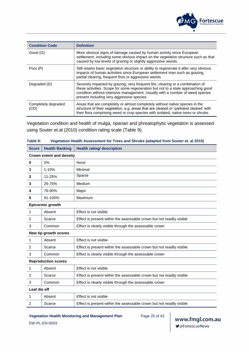
Vegetation condition and health of mulga, riparian and phreatophytic vegetation is assessed
using Souter et.al (2010) condition rating scale (Table 9).
Table 9: Vegetation Health Assessment for Trees and Shrubs (adapted from Souter et. al 2010)
Score Health Ranking Health rating/ description
Crown extent and density
0 0% None
1 1-10% Minimal
2 11-25% Sparse
3 26-75% Medium
4 76-90% Major
5 91-100% Maximum
Epicormic growth
1 Absent Effect is not visible
2 Scarce Effect is present within the assessable crown but not readily visible
3 Common Effect is clearly visible through the assessable crown
New tip growth scores
1 Absent Effect is not visible
2 Scarce Effect is present within the assessable crown but not readily visible
3 Common Effect is clearly visible through the assessable crown
Reproduction scores
1 Absent Effect is not visible
2 Scarce Effect is present within the assessable crown but not readily visible
3 Common Effect is clearly visible through the assessable crown
Leaf die off
1 Absent Effect is not visible
2 Scarce Effect is present within the assessable crown but not readily visible

Vegetation Health Monitoring and Management Plan Page 26 of 43
EW-PL-EN-0003
Score Health Ranking Health rating/ description
3 Common Effect is clearly visible through the assessable crown
Presence of Mistletoe
1 Absent Effect is not visible
2 Scarce Effect is present within the assessable crown but not readily visible
3 Common Effect is clearly visible through the assessable crown
Bark Condition
0 Intact Intact bark
1 Minor Minor cracks
2 Moderate Moderate bark cracks
3 Extensive Extensive bark cracks
4 Absent Long term dead tree
4.4.2 Erosion patterns
A visual assessment of erosion will be conducted, using the descriptive characteristics in Table 9
and 10.
Table 10: Erosion features as per Tongway and Hindley (2004)
Type of Erosion Description
Sheeting or sheet erosion (E)
The progressive removal of very thin layers of soil across extensive areas, with few if any sharp discontinuities to demarcate them. This is not always easy to detect with assurance, and may need to be inferred from other soil surface features, such as downslope eroded materials, or surface nature. It is sometimes confused with scalded surfaces, but characteristically is associated with gradational or uniform textured soils.
Pedestalling (P) The result of removing soil by erosion of an area to a depth of at least several cm, leaving the butts of surviving plants on a column of soil above the new general level of the landscape. Exposed roots are a hallmark of this erosion form. This is a sign that the soil type itself is very erodible and that loss of vegetation in the landscape was preceded by erosion, and not the other way about. Often associated with stones in the post mining environment.
Rills and gullies (R)
Are channels cut by flowing water. Rills are less than 300 mm deep and gullies are greater than 300 mm deep (McDonald et al). They may be initiated by water flowing down sheep or cattle paths. Their presence is a sure sign that water flows rapidly off the landscape, often carrying both litter and soil with it. They are aligned approximately with the maximum local slope.
Terracettes (T) Are abrupt walls from 1 to 10 cm or so high, aligned with the local contour, Terracettes progressively cut back up-slope, the eroded material being deposited in an alluvial fan downslope of the feature. The location of a terracette should be noted in the comments of the landscape organisation sheet for the line transect so that its progress upslope can be monitored over time. A change of zone will occur at the location of the terracette and it is assessed as occurring in the upslope zone (i.e. it will have an Erosion type and Severity class value of 1 or 2. The erosion type downslope of the terracette may be sheeting with alluvial deposits.
Scalding (S) Is the result of massive loss of A-horizon material in texture-contrast soils which exposes the A2 or B horizon which are typically very hard when dry and have extremely low infiltration rates. Scalds have a productive potential of zero, and pond or shed water

Vegetation Health Monitoring and Management Plan Page 27 of 43
EW-PL-EN-0003
Type of Erosion Description
readily. They are often on flat landscapes, though not exclusively, whereas sheeting is on gentle slopes.
Table 11: Erosion Severity and classes (Tongway and Hindley 2004)
Severity Class
Insignificant 4
Slight 3
Moderate 2
Severe 1
4.4.3 Multi-Spectral Imagery
Vegetation Health can be measured using remote sensed data. There are a number of Indices
that can be used, but the most commonly currently applied in Normalised Difference Vegetation
Index (NDVI). This index is used by Fortescue in vegetation health monitoring, but future
monitoring may investigate different indices as they are developed.
NDVI is a vegetation index derived from multispectral imagery to provide a quantitative measure
of plant health/vigour. NDVI is a modulation ration between near infra-red (NIR) and red radiation
as per the formula NDVI = (NIR – red)/ (NIR +red). Values range from -1 (red dominant) to 1 (NIR
dominant). Healthy green vegetation (Chlorophyll content) exhibits low red and high NIR
reflectance, resulting in positive NDVI values.
The multispectral imagery used to derive NDVI measurements is generally captured to a spatial
resolution of 0.5 m.
The following tables provide on-ground and NDVI health score for trees and shrubs (Table 11)
and grasslands that have been developed through Fortescue’s monitoring programs (Table 12).
Table 12: On-ground and NDVI health score comparison for trees and shrubs
NDVI Category NDVI value range Health score ranking
Major decline <-0.3 1 to 2
Moderate decline -0.3 to -0.2 3
Low decline -0.2 to -0.1 4
Neutral -0.1 to 0.1 5
Low Gain 0.1 to 0.2 6
Moderate Gain 0.2 to 0.3 7 to 8
High Gain >0.3 9 to 11

Vegetation Health Monitoring and Management Plan Page 28 of 43
EW-PL-EN-0003
Table 13: On-ground and NDVI health score comparison for grasslands
NDVI Category NDVI value range Health score ranking
Major decline <-.03 1
Moderate decline -0.3 to -0.2 2
Low decline -0.2 to -0.1 3
Low decline to Neutral -0.1 to -0.05 4
Neutral --0.05 to 0.05 5
Neutral to Low Gain 0.05 to 0.1 6
Low Gain 0.1 to 0.2 7
Moderate Gain 0.2 to 0.3 8-9
High Gain >0.3 10-11
Ground based validation of NDVI will be undertaken concurrent with monitoring of transects, in
order to confirm the accuracy of NDVI satellite imagery based assessment. The individual
parameters will then be totalled to obtain a health score for each site. Comparison of the data
collected during the ground based validation process with the NDVI results will be achieved by
dividing the total health ranking into categories aligned with the NDVI categories.
Analysis of variance (ANOVA) or similar statistical test is then used to compare NDVI change
values between impact and reference sites and across all survey sites assessed using NDVI.

Vegetation Health Monitoring and Management Plan Page 29 of 43
EW-PL-EN-0003
Table 14: Summary of Conservation Significant Vegetation Health Monitoring
Vegetation Type Fortescue Sites
Design Monitoring parameters Method Monitoring Effort Timing and Frequency
All vegetation types All As per vegetation type Meteorological data Local weather stations
Tipping bucket rain gauge
One per operating site As per vegetation type
Environmental threats Visual assessment Visual assessment of the quadrat
Photo point monitoring Fixed photo points At least one per site
Sheet Flow Mulga Rail Nested design with 100 m transects installed upstream (reference) with 400 m transects installed downstream (impact) of the railway. 10 m x 10 m quadrats are nested on both reference and impact transects.
Condition and health Visual assessment (Table 8 and 9) Each mulga within the 10m x 10m quadrats August - September
Stem growth Physical measurement of stem diameter Each mulga within the 10m x 10m quadrats
Sheetflow Pressure transducer Upstream and downstream of existing rail infrastructure
Major erosion Erosion stakes
Visual assessment
1 samples per site
Groundcover Permanent circular plots 3 samples per quadrat
Phreatophytic Vegetation (including partially phreatophytic) Communities and potential Groundwater Dependent Ecosystems (GDE))
Mine 2,500 m2 quadrats containing ten mature sample trees
Groundwater (quality and level)
Monitoring bores Bores in close proximity to quadrat, where available
April - May
October - November
Surface water (quality and flow)
Peak level indicators
Rising stage samplers
Assessments per quadrat
Leaf water potential Scholander pressure chamber 3 samples per tree, 10 trees per quadrat
Condition and health Visual assessment (Table 8 and 10) 10 trees per quadrat
NDVI validation undertaken concurrent with field monitoring.
Assessment per site
Rail Two 50 m x 50 m quadrats in each zone.
Zones include:
• > 100m downstream
• 0-100 m downstream
• 0 m impact
• 0-100 m upstream
• > 100 m upstream
Groundcover
Condition and health
Visual assessment (Table 8 and 10) Assessment of the quadrat June-July
Condition and health NDVI validation undertaken concurrent with field monitoring.
Five zones, with two 50 m x 50 m quadrats. A total of ten quadrats per crossing
Riparian Vegetation (non GDE)
Rail and Mine 10m x 10m quadrats are nested on both reference and impact transects.
Condition and health Visual assessment 10 trees per site October – November
NDVI - June NDVI validation undertaken concurrent with field monitoring.
Assessment per site
Themeda Grasslands (TEC)/ Brockman Iron Cracking Clay (PEC)
Rail and Mine 10m x 10m quadrats, 6 quadrats in total, 3 impact, 3 reference
Weed Cover Count number of plants and estimate percentage cover
Assessments per quadrat May
Condition and health Visual assessment (Table 8) Assessments per quadrat

Vegetation Health Monitoring and Management Plan Page 30 of 43
EW-PL-EN-0003
Vegetation Type Fortescue Sites
Design Monitoring parameters Method Monitoring Effort Timing and Frequency
NDVI validation undertaken concurrent with field monitoring (optional)
Assessment per site
Major erosion Erosion stakes 1 samples per site
Visual assessment Assessments per quadrat
Grazing pressure Number of faecal units of all grazing animals and estimated ground disturbed by tracks and hoof marks counted.
Assessments per quadrat
Groundwater levels Monitoring bores, where available Bores in close proximity to quadrats where available

Vegetation Health Monitoring and Management Plan Page 31 of 43
EW-PL-EN-0003
4.4.4 Monitoring Program Review
The overarching monitoring program will be technically assessed and reviewed upon acceptance
of this plan6 and then every three years thereafter. The main objective of the assessment and
review will be to ensure that the methods, parameters and frequency used are considerate and
appropriate to the findings of the monitoring program. If no triggers are exceeded (detailed in
Table 14) after three years, the frequency of monitoring will be reduced to a frequency supported
by the review.
Monitoring sites may need to be adapted over time in response to project impacts.
The assessment and review will be undertaken by an independent Pilbara ecology expert with a
relevant tertiary qualification and a minimum 10 years terrestrial Pilbara ecology experience.
Contingency action (Section 4.5) and reporting requirements (Section 6) will be implemented
where required.
4.4.5 Data handling and Statistical Analysis
Data will be handled in accordance with the data handling protocol established as part of the
annual monitoring tender. The protocol will include the requirements as to data storage and
protection, data extraction, quality control, analysis, interpretation, reporting and presentation.
The protocol will also directly reference and align with the requirements detailed in Document
Control, Information Management (100-ST-DC-001) and Geographic Information Systems and
Raw Data Guidelines (100‐GU‐EN‐0009).
Statistical analysis of data will be undertaken where data permits. Where data capture allows,
analysis will include univariate or multivariate analysis, as deemed appropriate, to determine
whether there are any statistical variations in monitoring data.
A statistically significant difference will be determined objectively using accepted statistical
techniques with significance (P) set at P<0.05.
Statistical analysis methods for vegetation health monitoring may include:
• Scatterplots may be used for assessing relationships between parameters including
identification of situations where statistical inference is not feasible.
6 This is primarily due to the fact that a number conservation significant flora and vegetation monitoring programs have
been ongoing for over 5 years.

Vegetation Health Monitoring and Management Plan Page 32 of 43
EW-PL-EN-0003
• Statistical tests such as parametric tests for difference between means (T test, ANOVA)
and non-parametric test (Kruiskal Wallas etc.)
• Least Square Means plots (with error bars) may also be used to help interpret p-value
results with 95% confidence intervals of the difference between treatments also
considered.
4.5 Contingency Actions
Contingency actions will be initiated during construction, operational and decommissioning
activities when an exceedance of a trigger is identified, and monitoring indicates that
implemented management measures are not successfully mitigating impacts on conservation
values of vegetation health and/or the management objectives are not being achieved.

Vegetation Health Monitoring and Management Plan Page 33 of 43
EW-PL-EN-0003
Table 15: Trigger Criteria and Associated Contingency Actions
Approval Condition Type Measure/ Target Contingency Action
Eliwana Railway and Mine
Outcome Trigger Criteria: A statistically significant difference3 in primary parameter (see Table 7) trends at predicted impact areas in comparison to baseline monitoring values over two consecutive monitoring events.
OR
If mean vegetation index values within significant flora buffers7 of priority ecological communities is significantly different from the baseline monitoring values.
Threshold Criteria: A statistically significant difference3 in the primary parameter (see Table 7) trends between impact sites and baseline monitoring values.
AND
The decline is detected over four consecutive monitoring events and is associated with a decline in vegetation health condition in comparison to the reference sites.
AND
Subsequent investigation determine that the impacts are probably a result of the implementation of the proposal.
Trigger Contingency Actions
• Determine whether the changes observed in the impact sites are comparable to the observations in the reference sites.
• Re-examine applied monitoring parameters to validate they are operating within management levels and where necessary
implement changes to the water management system to address exceedance
• Ground truth the results of the disturbance to validate if findings of NDVI assessment are correct
• Increase vegetation monitoring frequency to a three-month cycle at VMUs where trigger criteria was exceeded in impact sites with
no comparable observation in the reference sites.
• After the four consecutive monitoring events, determine if threshold criteria have been exceeded and a management response is
required: compilation of all relevant, available data for detailed statistical analyses to further test the probability that project related
impacts account for the trends detected.
• If after the four consecutive monitoring events, a threshold exceedance has not been identified, resume standard monitoring
frequency.
Threshold Contingency Actions
• Implement contingency measures within 24 hours of the exceedance being identified.
• Identify the reasons for the change:
o Where it was caused by construction, operation or decommissioning activities, submit a plan with actions within 21 days of the
determination being made by the OEPA.
o Where it was not caused by construction, operation or decommissioning activities, resume standard monitoring frequency.
• Report the threshold exceedance to the OEPA within 7 days of the exceedance being identified.
• Provide evidence to the satisfaction of the OEPA which allows determination of the cause of the exceedance within 21 days of the
exceedance being identified.
• Where the exceedance is a result of construction, operation or decommissioning activities, submit a plan of actions within 21 days
of the determination being made by the OEPA.
• Continue to implement actions to remediate the exceedance until approval to cease has been given by the OEPA.
7 The buffers for PECs are 500 metres.

Vegetation Health Monitoring and Management Plan Page 34 of 43
EW-PL-EN-0003
5. COMPLIANCE
Fortescue ensures compliance with its legal obligations through first party quality assurance by
site and corporate environment teams with a focus on effective environmental management
through the implementation of the Fortescue wide Environmental Management System (EMS).
Fortescue has adopted a risk based approach to monitor compliance with its legal obligations.
Site environment teams will monitor their compliance with this Plan and the required site specific
management and monitoring programs using the Self-Verification of High Risk Environmental
Legal Obligations Guideline (100-GU-EN-0030).
Where non-conformance issues or opportunities for improvement are identified these will be
documented and tracked via Fortescue’s BMS.

Vegetation Health Monitoring and Management Plan Page 35 of 43
EW-PL-EN-0003
6. REPORTING
6.1 Annual Monitoring Report
An Annual Monitoring Report will be developed with the results of the vegetation health programs
across all Fortescue controlled sites. This report will outline the vegetation health monitoring data
captured during the reporting period and the analysis required to report compliance against
management targets and conditioned environmental objectives.
Monitoring reports will be provided to the State and Commonwealth Governments as dictated by
annual reporting requirements. In addition, the monitoring raw data will be made available to the
Western Australian State Government and the Commonwealth Government upon request or
where conditioned to provide it.
6.2 Annual Compliance Assessment Report
Fortescue is required to report against its compliance with the Vegetation Health Monitoring and
Management Plan in the Compliance Assessment report prepared in accordance with the
OEPA’s Post Assessment Guideline for Preparing a Compliance Assessment Report, Post
Assessment Guideline No. 3.
Annual Compliance Assessment Reports (CAR) will be submitted where required under a
Ministerial Statements with vegetation health related conditions:
6.3 Reporting of Potential Non-Compliances
Fortescue is required to report against vegetation health monitoring outcomes as per conditioned
timeframes. Management targets, triggers criteria and where required threshold criteria have
been identified in Table 1.
In the event that monitoring, tests, surveys or investigations indicate an exceedance of a
management target has occurred within the reporting period, Fortescue will:
• Where the exceedance is attributable to construction, operation or decommissioning
activities, report the exceedance in writing to the OEPA within 7 days of the exceedance
being identified.
• Implement the threshold contingency actions specified in Table 15 within 24 hours and
continue to implement those actions until the CEO has confirmed by notice in writing
that it has been demonstrated that the threshold criteria are being met and the
implementation of the threshold contingency actions is no longer required.

Vegetation Health Monitoring and Management Plan Page 36 of 43
EW-PL-EN-0003
• Investigate to determine the cause of the management targets being exceeded.
• Investigate to provide information for the OEPA to determine potential environmental
harm or alteration of the environment that occurred due to threshold criteria being
exceeded.
• Provide a report to the OEPA within 90 days of the exceedance being reported. The
report shall include:
o Details of threshold contingency actions implemented,
o The effectiveness of the threshold contingency actions implemented, against the
threshold criteria,
o The findings of the investigations,
o Measures to prevent the threshold criteria being exceeded in the future,
o Measures to prevent, control or abate the environmental harm which may have
occurred,
o Justification of the threshold remaining, or being adjusted based on better
understanding, demonstrating that outcomes will continue to be met.
In the event that monitoring, tests, surveys or investigations indicate that one or more
management actions have not been implemented, Fortescue will:
• Report the failure to implement management action(s) in writing to the OEPA within 7
days of identification
• Investigate to determine the cause of the management action(s) not being implemented
• Investigate to provide information for the OEPA to determine potential environmental
harm or alteration of the environment that occurred due to the failure to implement
management actions.
• Provide a report to the OEPA within 21 days of the reporting.

Vegetation Health Monitoring and Management Plan Page 37 of 43
EW-PL-EN-0003
7. ADAPTIVE MANAGEMENT
Fortescue will implement adaptive management practices to learn from the implementation of
mitigation measures, monitoring and evaluation against management targets, to more effectively
meet the conditioned environmental objective. Adaptive management practices that will be
assessed for the vegetation health management and monitoring program as part of this approach
may include:
• Evaluation of the monitoring program, data and comparison to baseline data and
reference sites on an annual basis to verify whether responses to project activities are
the same or similar to predictions.
• Evaluation of assumptions and uncertainties of the vegetation health management and
monitoring program.
• Re-evaluation of the risk assessment and revision of risk based priorities as a result of
monitoring outcomes.
• Review of data and information gathered over the review period that has increased
understanding of site environment in the context of the regional ecosystem.
• Review of management actions as the project matures and new management
measures and technologies become available that may be more effective for vegetation
health management.
• Assessment of changes which are outside the control of the project and the
management measures identified (i.e. a new project within the area or region; regional
change affecting vegetation health management).
• Evaluation and introduction of new or different monitoring methods due to changes in
technology.
• Review of the Vegetation Health Monitoring and Management Plan will be undertaken
every five years or as required by a condition.

Vegetation Health Monitoring and Management Plan Page 38 of 43
EW-PL-EN-0003
8. REVIEW OF THE PLAN
Review of this Plan will be undertaken every five years or as required by a condition. Revisions of
this Plan will be submitted to the relevant State and Commonwealth Governments for approval, in
accordance with relevant approval conditions.

Vegetation Health Monitoring and Management Plan Page 39 of 43
EW-PL-EN-0003
9. STAKEHOLDER CONSULTATION
Fortescue has undertaken extensive stakeholder consultation program whereby landowners,
regulators and other relevant parties have been consulted with regard to investigation and design
of the mine sites and port and rail infrastructure through the environmental approvals process.
The then Department of Environmental Regulation (DER), the then Office of the Environmental
Protection Authority (OPEA) and the then Department of the Environment (DoE) were consulted
and, where required, approved the content of the original plans for which this Plan will replace.
Table 15 will be updated following receipt of stakeholder comment as a result of the review and
approval process.
Table 16: Stakeholder Consultation, Comments and Responses
Stakeholder Correspondence Comments Changes
DWER – Terrestrial Ecosystems
CMS 17164 Revise the Vegetation Health Monitoring and Management Plan in accordance with previously provided advice prior to re-submission of the ERD.
The VHMMP has been revised to take into consideration previously provided advice from DWER (UID 71373).
CMS 17164
CMS 171123
Revise the Vegetation Health Monitoring and Management Plan to include management measures that will be taken, including details of objectives/ outcomes, monitoring regimes, and measurable thresholds and triggers to ensure impacts to flora and vegetation are not greater than predicted
The VHMMP includes including details of objectives/ outcomes, monitoring regimes, and triggers and thresholds in accordance with EPA Guidance EAG 17 Preparation of management plans under Part IV of the Environmental Protection Act 1986.

Vegetation Health Monitoring and Management Plan Page 40 of 43
EW-PL-EN-0003
10. REFERENCES
Fortescue Metals Group (FMG), 2017. PER: Eliwana Mine Proposal – Surface Water Impact
Assessment.
Fortescue Metals Group (FMG), 2017. PER: Eliwana Rail Proposal – Surface Water Impact
Assessment.
Fortescue Metals Group (FMG), 2017. PER: Eliwana Rail Proposal – Groundwater Impact
Assessment.
Fortescue Metals Group (FMG), 2017. PER: Eliwana Mine Proposal – Groundwater Impact
Assessment.
Fortescue Metals Group (FMG), 2017. PER: Eliwana Mine Proposal –Eliwana Mine Closure Plan
(EW-PL-EN-0001).
Fortescue Metals Group (FMG), 2017. PER: Eliwana Rail Proposal –Integrated Rail Network
Closure Plan (R-PL-EN-0041).

Vegetation Health Monitoring and Management Plan Page 41 of 43
EW-PL-EN-0003
Figure 1: Surface Water Management Near Conservation Significant Vegetation: Eliwana Rail

Caves Creek
Weelumurra Creek
Barnett Creek
Wackilina Creek
Forte
scue
Rive
r Sou
th B
ranc
h
560,000
560,000
570,000
570,000
580,000
580,000
590,000
590,000
7,530,
000
7,530,
000
7,540,
000
7,540,
000
Requested By: A. SullivanDrawn By: S. CostelloRevised By: scostelloApproved By: P. MastalirScale: 1:100,000Coordinate System: GDA 1994 MGA Zone 50Document Name: 750EW_MP_EN_0007.033_1_EMP_r0
Date: 08-Jun-18Size: A3L
Revision: 3Confidentiality: 1
0 1 2 3 4 5
Kilometres
±FMG accepts no liability and gives no representation or warranty, express or implied, as to theinformation provided including its accuracy, completeness, merchantability or fitness for purpose.
Data Sources: Rio Rail, RTIO.All other data, FMG, 2018.
LEGENDRail Development Envelope
Eliwana Rail Indicative Footprint
Indicative Culverts
Indicative Drains
Major Creeks
FMG Proposed Rail Alignment
Rio Tinto Rail
Proposed Rail Catchment Areas
Surface Water Management Measures near Conservation Significant Vegetation
Map 1 of 3
Potentially Groundwater Dependent VegetationAcBTe
EvAtuApyTErTHt
EvVfApyCYPvTHt
Potentially Sheetflow Dependent MulgaAanCHf
Representative of TECPANdTHs
THsERIb
VfERIb
Representative of PECAanVfTHt
VfASl
Other Vegetation Communities
Weelumurra Creek
Caves CreekWackilina Creek
CAVES CREEK CROSSING WEELUMURRA CREEK CROSSING
Note: 'Indicative Culverts' symbol sizes are scaled based on indicative cross sectional area of culvert openingNote: For 'Indicative Culverts' and 'Indicative Drains', see Surface Water Impact Assessment (750EE-3100-AS-HY-0002) for drainage infrastructure and design process

Caves Creek
Duck Creek
Boolg
eeda C
reek
520,000
520,000
530,000
530,000
540,000
540,000
550,000
550,000
7,520,
000
7,520,
000
7,530,
000
7,530,
000
Requested By: A. SullivanDrawn By: S. CostelloRevised By: scostelloApproved By: P. MastalirScale: 1:100,000Coordinate System: GDA 1994 MGA Zone 50Document Name: 750EW_MP_EN_0007.033_2_EMP_r0
Date: 08-Jun-18Size: A3L
Revision: 3Confidentiality: 1
0 1 2 3 4 5
Kilometres
±FMG accepts no liability and gives no representation or warranty, express or implied, as to theinformation provided including its accuracy, completeness, merchantability or fitness for purpose.
Data Sources: All data, FMG, 2018.
LEGENDRail Development Envelope
Eliwana Rail Indicative Footprint
Indicative Culverts
Indicative Drains
Major Creeks
FMG Proposed Rail Alignment
Proposed Rail Catchment Areas
Surface Water Management Measures near Conservation Significant Vegetation
Map 2 of 3
Potentially Groundwater Dependent VegetationEvAcCcERIt
EvAcMgERIt
Groundwater Dependent VegetationEvAcVfDICf
Potentially Sheetflow Dependent MulgaAanCHf
Locally SignificantCdAhTw
ElAaTbt
ElEpAbTe
Regionally SignificantGsTak
Other Vegetation Communities
Duck Creek
Duck Creek
DUCK CREEK CROSSING 3 DUCK CREEK CROSSING 1 & 2
Note: 'Indicative Culverts' symbol sizes are scaled based on indicative cross sectional area of culvert openingNote: For 'Indicative Culverts' and 'Indicative Drains', see Surface Water Impact Assessment (750EE-3100-AS-HY-0002) for drainage infrastructure and design process

Duck Creek
Caves Creek
Eliwana
490,000
490,000
500,000
500,000
510,000
510,000
520,000
520,000
7,510,
000
7,510,
000
7,520,
000
7,520,
000
7,530,
000
7,530,
000
Requested By: A. SullivanDrawn By: S. CostelloRevised By: scostelloApproved By: P. MastalirScale: 1:100,000Coordinate System: GDA 1994 MGA Zone 50Document Name: 750EW_MP_EN_0007.033_3_EMP_r0
Date: 08-Jun-18Size: A3L
Revision: 3Confidentiality: 1
0 1 2 3 4 5
Kilometres
±FMG accepts no liability and gives no representation or warranty, express or implied, as to theinformation provided including its accuracy, completeness, merchantability or fitness for purpose.
Data Sources: All data, FMG, 2018.
LEGEND[i Fortescue Projects
Rail Development Envelope
Eliwana Rail Indicative Footprint
Indicative Culverts
Indicative Drains
Major Creeks
FMG Proposed Rail Alignment
Proposed Rail Catchment Areas
Surface Water Management Measures near Conservation Significant Vegetation
Map 3 of 3
Potentially Groundwater Dependent VegetationEvAcCcERIt
EvAcMgERIt
EvExAcTHt
Groundwater Dependent VegetationEcAcEuaTe
Regionally SignificantGsTak
Other Vegetation Communities
Note: 'Indicative Culverts' symbol sizes are scaled based on indicative cross sectional area of culvert openingNote: For 'Indicative Culverts' and 'Indicative Drains', see Surface Water Impact Assessment (750EE-3100-AS-HY-0002) for drainage infrastructure and design process

Vegetation Health Monitoring and Management Plan Page 42 of 43
EW-PL-EN-0003
Figure 2: Environmental Considerations and Groundwater Impact Assessment Areas: Eliwana Rail

CH0
CH20
CH80
CH60
CH40
CH120
CH100
CH140
12
4
6
5
3
Millstream Water Reserve
Millstream Water Reserve
Solomon
Eliwana
Sheila Valley
Brockman 4
Silvergrass
Turner West
Brockman 2Nammuldi
480,000
480,000
490,000
490,000
500,000
500,000
510,000
510,000
520,000
520,000
530,000
530,000
540,000
540,000
550,000
550,000
560,000
560,000
570,000
570,000
580,000
580,000
590,000
590,000
600,000
600,000
610,000
610,0007,490,
000
7,490,
000
7,500,
000
7,500,
000
7,510,
000
7,510,
000
7,520,
000
7,520,
000
7,530,
000
7,530,
000
7,540,
000
7,540,
000
7,550,
000
7,550,
000
7,560,
000
7,560,
000
7,570,
000
7,570,
000
Requested By: M CarrollDrawn By: M CarrollRevised By: mcarrollApproved By:Scale: 1:496,231Coordinate System: GDA 1994 MGA Zone 50Document Name: Potential GDV
Figure 6Environmental Considerations and
Groundwater Impact Assessment
Areas
Date: 1/06/2018Size: A4L
Revision: 1Confidentiality: 1
FMG accepts no liability and gives no representation or warranty, express orimplied, as to the information provided including its accuracy, completeness,merchantability or fitness for purpose.
PER Rail Alignment
Eliwana Rail Camp Area
FMG Rail Alignments
Rio Tinto Rail
[i FMG Locations
[i Rio Tinto Mines
Vegetation Mapping Extents
Groundwater Impact Assessment Areas
Potentially Groundwater Dependent Assemblage
Groundwater Dependent Assemblage
PDWSA

1
Millstream Water Reserve
550,000
550,000
560,000
560,000
570,000
570,000
7,530,
000
7,530,
000
7,540,
000
7,540,
000
Requested By: M CarrollDrawn By: M CarrollRevised By: mcarrollApproved By:Scale: 1:120,114Coordinate System: GDA 1994 MGA Zone 50Document Name: Potential GDV - GIAA1
Figure 7lEnvironmental Considerations in
Groundwater Impact Assessment
Area 1
Date: 1/06/2018Size: A4L
Revision: 0Confidentiality: 1
FMG accepts no liability and gives no representation or warranty, express orimplied, as to the information provided including its accuracy, completeness,merchantability or fitness for purpose.
PDWSA
PER Rail Alignment
Rio Tinto Rail
Watercourse
Groundwater Impact Assessment Areas
Rail_SWFeature_Aug2004
Rail_SWFeature_Aug2013
Potentially Groundwater Dependent Assemblage
Groundwater Dependent Assemblage
Vegetation Mapping Extents
Pool 32
Pool 33
Pool 22
Pool 31
Pool 24
Pool 23

2
520,000
520,000
530,000
530,000
7,530,
000
7,530,
000
Requested By: M CarrollDrawn By: M CarrollRevised By: mcarrollApproved By:Scale: 1:48,669Coordinate System: GDA 1994 MGA Zone 50Document Name: Potential GDV - GIAA2
Figure 8Environmental Considerations in
Groundwater Impact Assessment
Area 2
Date: 1/06/2018Size: A4L
Revision: 0Confidentiality: 1
FMG accepts no liability and gives no representation or warranty, express orimplied, as to the information provided including its accuracy, completeness,merchantability or fitness for purpose.
PDWSA
PER Rail Alignment
Rio Tinto Rail
Watercourse
Groundwater Impact Assessment Areas
Rail_SWFeature_Aug2004
Rail_SWFeature_Aug2013
Potentially Groundwater Dependent Assemblage
Groundwater Dependent Assemblage
Vegetation Mapping Extents
Pool 25
Pool 28
Pool 26Pool 27
Pool 9
Pool 7Pool 6
Pool 3
Pool 2Pool 10
Pool 8Pool 4Pool 1
Pool 15
Pool 29Pool 30
Pool 5
Pool 12Pool 11
Pool 13Pool 14

3
Pool 21
520,000
520,000
Requested By: M CarrollDrawn By: M CarrollRevised By: mcarrollApproved By:Scale: 1:34,944Coordinate System: GDA 1994 MGA Zone 50Document Name: Potential GDV - GIAA3
Figure 9Environmental Considerations in
Groundwater Impact Assessment
Area 3
Date: 1/06/2018Size: A4L
Revision: 0Confidentiality: 1
FMG accepts no liability and gives no representation or warranty, express orimplied, as to the information provided including its accuracy, completeness,merchantability or fitness for purpose.
PDWSA
PER Rail Alignment
Rio Tinto Rail
Watercourse
Groundwater Impact Assessment Areas
Rail_SWFeature_Aug2004
Rail_SWFeature_Aug2013
Potentially Groundwater Dependent Assemblage
Groundwater Dependent Assemblage
Vegetation Mapping Extents

4510,000
510,000
520,000
520,000
7,520,
000
7,520,
000
Requested By: M CarrollDrawn By: M CarrollRevised By: mcarrollApproved By:Scale: 1:48,669Coordinate System: GDA 1994 MGA Zone 50Document Name: Potential GDV - GIAA4
Figure 10Environmental Considerations in
Groundwater Impact Assessment
Area 3
Date: 1/06/2018Size: A4L
Revision: 0Confidentiality: 1
FMG accepts no liability and gives no representation or warranty, express orimplied, as to the information provided including its accuracy, completeness,merchantability or fitness for purpose.
PDWSA
PER Rail Alignment
Rio Tinto Rail
Watercourse
Groundwater Impact Assessment Areas
Rail_SWFeature_Aug2004
Rail_SWFeature_Aug2013
Potentially Groundwater Dependent Assemblage
Groundwater Dependent Assemblage
Vegetation Mapping Extents
Pool 17
Pool 16
Pool 18
Pool 19
Pool 20
Pool 21

5
510,000
510,000
7,520,
000
7,520,
000
Requested By: M CarrollDrawn By: M CarrollRevised By: mcarrollApproved By:Scale: 1:34,944Coordinate System: GDA 1994 MGA Zone 50Document Name: Potential GDV - GIAA5
Figure 11Environmental Considerations in
Groundwater Impact Assessment
Area 5
Date: 1/06/2018Size: A4L
Revision: 0Confidentiality: 1
FMG accepts no liability and gives no representation or warranty, express orimplied, as to the information provided including its accuracy, completeness,merchantability or fitness for purpose.
PDWSA
PER Rail Alignment
Rio Tinto Rail
Watercourse
Groundwater Impact Assessment Areas
Rail_SWFeature_Aug2004
Rail_SWFeature_Aug2013
Potentially Groundwater Dependent Assemblage
Groundwater Dependent Assemblage
Vegetation Mapping Extents

6
520,000
520,000
7,510,
000
7,510,
000
Requested By: M CarrollDrawn By: M CarrollRevised By: mcarrollApproved By:Scale: 1:40,276Coordinate System: GDA 1994 MGA Zone 50Document Name: Potential GDV - GIAA6
Figure 12Environmental Considerations in
Groundwater Impact Assessment
Area 6
Date: 1/06/2018Size: A4L
Revision: 0Confidentiality: 1
FMG accepts no liability and gives no representation or warranty, express orimplied, as to the information provided including its accuracy, completeness,merchantability or fitness for purpose.
PDWSA
PER Rail Alignment
Rio Tinto Rail
Watercourse
Groundwater Impact Assessment Areas
Rail_SWFeature_Aug2004
Rail_SWFeature_Aug2013
Potentially Groundwater Dependent Assemblage
Groundwater Dependent Assemblage
Vegetation Mapping Extents

Vegetation Health Monitoring and Management Plan Page 43 of 43
EW-PL-EN-0003
Appendix 1: Risk Assessment Relationship Matrix

Risk
Cause/ Unwanted Event
Ref # Management Action Rail Mine Rail Mine
2.1 Training X X
2.2
Drainage infrastructure location
and design
2.3
Incorporate drainage
infrastructure X X
2.4 Align linear infrastructure X X
2.5
Dewatering and water
discharge X
2.6
Locations of conservation
significant flora and vegetation
are known X X
2.7
Weed locations are known and
management measures
idenified
2.8 Dust management
2.9 Incident management X X X
2.10 Rehabilitation
Ref # Management Action
2.1 Training
2.2
Know locations of fauna
identified
2.3
Drainage infrastructure location
and design
2.4 Pre clearance surveys
2.6 Weed management
2.7 Fauna exclusion and/or egress
2.8 Feral animal control
2.9 Dust mitigation
2.14 Progressive rehabilitation
Objective 2 Establish management stratgies to minimise the potential impacts on conservation significant flora and vegetation within Fortescue Controlled Sites
MineRail
X X
Conduct progressive rehabilitation of disturbed areas no longer required for operations prioritising areas with
known conservation significant fauna and associated habitat.
Develop and implement a Feral Animal Control Program to effectively manage and control feral animals within
Fortescue controlled sites to minimise impacts on conservation significant fauna.
To minimize the potential for dust deposition on vegetation on conservation significant fauna habitat,
implement relevant dust suppression measures within identified high risk areas
When conservation significant fauna species have been recorded in proposed impact areas within associated
habitat, and the records have been verified through survey activities undertaken in the last five years, ground-
truth the area and similar habitats within the area. Where individual animals are present implement mitigation
measures, in consultation with DPaW, including the relocation of fauna, prior to disturbance.
Prior to conducting ground disturbance activities, ensure known locations of priority weed populations are
identified and management measures to minimise the potential for weed spread are included in the LUC.Fauna management measures including exclusion or exit/egress structures, to minimise potential impacts to
conservation significant fauna are in place:
- For mining infrastructure that poses a fauna entrapment and drowning risk (including storage ponds and
tailings storage areas).
- When conducting excavation or trenching activities.
Direct death to
conservation
significant flora and
vegetation
Alterations to
surface water flows
Clearing will reduce
extent, disturbance
to flora or
ecological
Prior to conducting ground disturbance acivities, esnure known locations of conservation significant fauna and
their associated fauna habitat and buffers are identified and management measures are implemented.
Ensure drainage infrastructure location and design aligns with the risk assessment outcomes to minimise
interference and disruption of natural surface water flows that support conservation significant fauna habitat.
Dust generation
Increased fire
frequency/intensityWeed spread
Full Description
X
X X
X X
X X
Rail Mine Rail Mine
X
Rail
X
Mine
X
X
X
X
X
X
XX
Ensure staff and contractors are provided with appropriate training to ensure conservation significant fauna
and associated habitat are protected.
Groundwater
drawdown
Indirect death to conservation significant flora and vegetation
X
X