vegetation cover change detection and assessment in arid
TRANSCRIPT
Solid Earth, 7, 713–725, 2016
www.solid-earth.net/7/713/2016/
doi:10.5194/se-7-713-2016
© Author(s) 2016. CC Attribution 3.0 License.
Vegetation cover change detection and assessment in arid
environment using multi-temporal remote sensing images
and ecosystem management approach
Anwar Abdelrahman Aly1,3, Abdulrasoul Mosa Al-Omran1, Abdulazeam Shahwan Sallam1,
Mohammad Ibrahim Al-Wabel1, and Mohammad Shayaa Al-Shayaa2
1Soil Science Dept., King Saud University, Riyadh, Saudi Arabia2Agricultural Extension and Rural Community Dept., King Saud University, Riyadh, Saudi Arabia3Soil and Water Science Dept., Faculty of Agric., Alexandria University, Alexandria, Egypt
Correspondence to: Abdulrasoul Mosa Al-Omran ([email protected], [email protected])
Received: 21 February 2016 – Published in Solid Earth Discuss.: 25 February 2016
Revised: 20 April 2016 – Accepted: 21 April 2016 – Published: 29 April 2016
Abstract. Vegetation cover (VC) change detection is essen-
tial for a better understanding of the interactions and inter-
relationships between humans and their ecosystem. Remote
sensing (RS) technology is one of the most beneficial tools
to study spatial and temporal changes of VC. A case study
has been conducted in the agro-ecosystem (AE) of Al-Kharj,
in the center of Saudi Arabia. Characteristics and dynamics
of total VC changes during a period of 26 years (1987–2013)
were investigated. A multi-temporal set of images was pro-
cessed using Landsat images from Landsat4 TM 1987, Land-
sat7 ETM+2000, and Landsat8 to investigate the drivers re-
sponsible for the total VC pattern and changes, which are
linked to both natural and social processes. The analyses of
the three satellite images concluded that the surface area of
the total VC increased by 107.4 % between 1987 and 2000
and decreased by 27.5 % between years 2000 and 2013. The
field study, review of secondary data, and community prob-
lem diagnosis using the participatory rural appraisal (PRA)
method suggested that the drivers for this change are the de-
terioration and salinization of both soil and water resources.
Ground truth data indicated that the deteriorated soils in the
eastern part of the Al-Kharj AE are frequently subjected to
sand dune encroachment, while the southwestern part is fre-
quently subjected to soil and groundwater salinization. The
groundwater in the western part of the ecosystem is highly
saline, with a salinity ≥ 6 dS m−1. The ecosystem manage-
ment approach applied in this study can be used to alike AE
worldwide.
1 Introduction
Many researchers working in ecosystem management (EM)
find it necessary to integrate communities as part of an
ecosystem rather than treating them as a separate entity (Aly,
2007; Reed et al., 2009). The ecosystems give humankind
many services such as provisioning services (i.e., food, water,
timber, fiber, and genetic resources), regulating services (i.e.,
the regulation of climate, floods, disease, and water qual-
ity), cultural services (i.e., recreational, aesthetic, and spir-
itual benefits), and supporting services (i.e., soil formation,
pollination, and nutrient cycling) (Aly, 2007; Bochet, 2015).
Soil and vegetation as a part of ecosystems also give many
services to the humankind and play an important role in the
earth system. The soil can act as a filter of heavy metals
and parasitic microorganisms; consequently, prevent plant
and groundwater from contamination (Brevik et al., 2015;
Keesstra et al., 2012). Implementing sustainable EM implies
improving the quality of community life without depleting
the ecosystems for future generations. Brodt et al. (2011)
and Maltby (2000) said that the newer concept of sustain-
ability includes three dimensions, defined by three broad
goals: economic opportunity, social equity, and environmen-
tal health. When these goals are reached, the sustainability
will be achieved. However, Richardson et al. (2010) con-
cluded that severe degraded ecosystem may shift the EM
goals from ecosystem restoration and sustainability to recon-
structing entirely new ecosystem. Since the late 1980s an in-
tegration between EM, RS, GIS, and GPS has received sub-
Published by Copernicus Publications on behalf of the European Geosciences Union.

714 A. A. Aly et al.: Vegetation cover change detection and assessment in arid environment
stantial consideration in the literature (Ehlers et al., 1989;
Hinto, 1996; Trabaquini et al., 2012). This integration helps
us tackle more research problems related to EM. Neverthe-
less, the approaches by which these techniques are integrated
have become more complicated due to the diversification of
the fields that are required to be integrated (Gao, 2002). In-
deed the RS, GIS, and GPS provide desired technologies
for land and environmental management (Leh et al., 2015;
Seelan et al., 2003; Zucca et al., 2015). Two terms are usu-
ally used in abundance by land management researchers:
land cover (LC) and land use (LU). The LC is defined as
a physical material-covered earth surface; LU is the human
activities or economic functions related to specific part of
land (Singh, 2013). The LC comprises vegetation, asphalt,
bare ground, rivers, lakes, etc., whilst the vegetation cover
(VC) includes only planted land, i.e., grass, trees (Aly, 2007;
Singh, 2013). Loss of VC and plant species diversity reduces
resistance of soil erosion and soil fertility (Berendse et al.,
2015; Cerdà and Doerr, 2005; Yu and Jia, 2014). The VC im-
proves the infiltration rate and decreases surface runoff and
erosion (Cerdà, 1999). Furthermore, the VC has considerably
affected the global warming process through emissions of
CO2. However, C sequestration by afforestation in terrestrial
ecosystems could contribute to the decrease of atmospheric
CO2 rates (Muñoz-Rojas et al., 2015). The analysis of the
impact of LU changes on landscape processes can aid the
future policies of the agro-ecosystem (AE) (Debolini et al.,
2015). The RS technology is usually used in EM (Almeida
et al., 2005; Croft et al., 2012; Gong et al., 2015; Mohawesh
et al., 2015; Rawat, 2013; Xie, 2008). Vrieling (2006) con-
cluded that four types of factors are included by remote sens-
ing (RS): topography, soil properties, VC, and management
practices. Aly (2007) used the RS technology in the holis-
tic approach of AE sustainable management in Siwa, lo-
cated in Egypt. Furthermore, Setiawan and Yoshino (2012)
compared series of images through time to derive the land
changes in Tsukuba, Japan. Often remote sensing imagery
is imported into GIS software to facilitate analysis (Fichera
et al., 2012). Chowdary et al. (2001) used the Indian re-
mote sensing satellite data of 1988 and 1996 to monitor the
land resources and evaluate the land cover changes through
a comparison of images acquired for same area at different
times. Yang et al. (1999) analyzed different temporal images
of Landsat MSS (1978 and 1981) and TM (1988, 1992, and
1996) for the purpose of detecting the coastal line change
of Yellow River Delta. Suliman (2001) acquired three dif-
ferently dated satellite Thematic Mapper (TM) images for
1984, 1993, and 1999, in addition to topographic maps, to
obtain a new vulnerability map that can detect erosion, recla-
mation, and development of Rosetta and Mutubas districts
(in Arabic, markazes). El-Bana (2003) used two differently
dated satellite TM images to obtain quantified changes in
LU in the northwestern part of Kafr el-Sheikh Governorate,
Egypt. Furthermore, Aly (2007) used three satellite images
from 1973 (MSS), 2000 (ETM), and 2005 (ASTER) to detect
changes of LC in Siwa oasis, Egypt. Desprats et al. (2014)
used satellite remote sensing to identify VC in the western
part of the Kingdom of Saudi Arabia (KSA). The use of
RS and field studies in the KSA can be summarized: sand
dunes and soil and groundwater deterioration are considered
the main problems that threaten the AEs (Algahtani et al.,
2015; Aly et al., 2015a; Alyemeni, 2000). The sand dunes
cover more than quarter of KSA surface (Alyemeni, 2000).
These include four major sandy deserts (Nafud, Dahna, Rub’
al Khali, and Juffarah) in addition to other locally scattered
sandy areas (Alyemeni, 2000). AEs are rarely found in the
vast dryland of KSA; furthermore, found AEs were usually
considered fragile (Al-Omran et al., 2014). Al-Kharj is a pro-
ductive AE set in a desert depression in central KSA and is
irrigated by waters originating from natural springs and dug
wells with lush date palms, other fruits (e.g., grapes), and
vegetables (e.g., lettuce, carrots, tomatoes, cucumbers, and
melons). It is a fragile dryland AE that has a low degree of
resilience to external stresses and has a low carrying capacity
(Al-Omran et al., 2014). Some primary studies recorded that
the soils and groundwater in Al-Kharj were deteriorating in
an alarming way to lower suitability classes and sometimes
becoming unsuitable for cultivation (Al-Harbi, 2005). Con-
sequently, the main objectives of this study are (i) to define
the Al-Kharj, Saudi Arabia, AE problems and sustainabil-
ity using community diagnosis and field study; (ii) to detect
the Al-Kharj’s VC changes using RS; and (iii) to develop in-
terventions that help restore the ecosystem’s functions and
integrity and thus enhance the community’s livelihood and
promote social equity.
2 Materials and methods
2.1 Study area
The Al-Kharj is a fragile dryland AE that has low resilience
and carrying capacity. The ecosystem is located in arid con-
ditions in the middle of the Kingdom of Saudi Arabia, east of
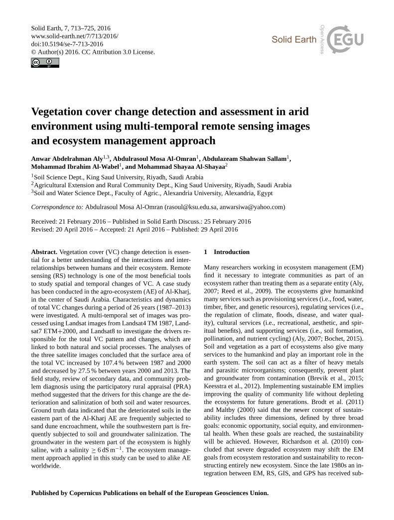
Riyadh city. It is located at 24◦8′54′′ N, 47◦18′18′′ E (Fig. 1).
The groundwaters are considered the main source of irriga-
tion, and the AE grows various fruits and vegetables (e.g.,
date palms and grapes, tomatoes, cucumbers, melons) (Al-
Omran et al., 2013). The Al-Kharj is located at 1360 m above
sea level and its area is about 20 000 km2 with a population of
more than 600 000 people. There are only two large towns in
the studied AE (Dilam and Asseeh, with populations of 8492
and 49 856 people, respectively); however, there are three
small towns (Al-Hayathim, Al-Yamamah, and Sulamiyya).
Furthermore, the AE includes many small hamlets and vil-
lages (Hagras et al., 2013). The Wadi (valleys) of Al-Kharj is
discharged by water from Wadi Hanifa and some other small
wadis to compensate for part of the consumed groundwater.
Al-Kharj has included numerous springs since ancient times;
consequently, it is considered richest ecosystem in water re-
Solid Earth, 7, 713–725, 2016 www.solid-earth.net/7/713/2016/
A. A. Aly et al.: Vegetation cover change detection and assessment in arid environment 715
Figure 1. Location of the study area.
sources in the KSA. The studied AE has supported the KSA
with grain, dairy products, and other produced crops and live-
stock products. Recently, the springs of Al-Kharj have dried
up dramatically, like those in other places of the kingdom,
due to recurring drought (McLaren, 2008).
2.2 Ecosystem problem identification (community)
The purpose of this part of the fieldwork is to identify the
human activities and practices of the region, particularly
those that enhance ecosystem degradation within socioeco-
nomic and cultural constructs (Swallow et al., 2009). The
knowledge, attitude, and practices (KAP) study was con-
ducted using the participatory rural appraisal (PRA) method,
which includes the review of earlier studies, field observa-
tions, substantial indicators, community townhall meetings,
a sequence of one-on-one meetings, and buildup question-
naires. The PRA approach was used in this study to under-
take a diagnosis of the community and the issues of land
productivity, as well as their importance, as distinguished by
the ecosystem community in order to interpret the changes
found by RS (Mushove and Vogel, 2005; Shepherd, 2008).
The PRA is a concentrated, regular but semi-structured learn-
ing practice conducted in a studied community by multidisci-
plinary teamwork with complete contribution of the ecosys-
tem community and stakeholders (Chambers, 1994; Mikkel-
son, 1994). The PRA helps the researcher and community
identify specific ecosystem problems and suggest solutions.
The townhall meeting was held in Al-Kharj and included
around 250 stakeholders and farmers. The questionnaire was
field-tested, and modifications were made based on the re-
sults. The most suitable format appears to be an easy-to-
respond, non-time-consuming “tick box” structure. To this
end, 123 suitable questionnaires were designed collectively
by the research team in consultation with the local commu-
nity to gather field information (Aly, 2007; Reed et al., 2009).
Coding for different variables has been accomplished, infor-
mation gathered through the 123 administered questionnaires
has been statistically analyzed, and the tasks accomplished
are recorded in this study.
2.3 Remote sensing image characterization
RS by satellite images has been used since 1972 by the first
satellite, Landsat1 (Dagci and Kusek, 2008). Due to the vast
study area, the proposed methodology is based on the use
of remote sensing data. The very low cloud coverage on the
Arabian Peninsula allows the acquisition of global imaging
coverage of the study area over several years. In this study, a
multi-temporal set of RS data of the Al-Kharj AE has been
used to investigate vegetation cover changes (Fichera et al.,
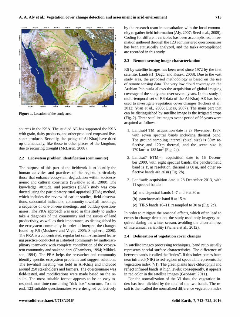
2012; Yuan et al., 2005; Lucas, 2007). The main part that
can be distinguished by satellite image is the irrigated crops
(Fig. 2). Three satellite images over a period of 26 years were
acquired as follows.
1. Landsat4 TM: acquisition date is 27 November 1987,
with seven spectral bands including thermal band.
The ground sampling interval (pixel size) is 30 m re-
flective and 120 m thermal, and the scene size is
170 km2× 185 km2 (Fig. 2a).
2. Landsat7 ETM+: acquisition date is 16 Decem-
ber 2000, with eight spectral bands; the panchromatic
band is 15 m resolution, thermal is 60 m, and other re-
flective bands are 30 m (Fig. 2b).
3. Landsat8: acquisition date is 28 December 2013, with
11 spectral bands:
(a) multispectral bands 1–7 and 9 at 30 m
(b) panchromatic band 8 at 15 m
(c) TIRS bands 10–11, resampled to 30 m (Fig. 2c).
In order to mitigate the seasonal effects, which often lead to
errors in change detection, the study used only imagery ac-
quired during the winter season, avoiding the uncertainness
of interannual variability (Fichera et al., 2012).
2.4 Delineation of vegetation cover changes
In satellite images processing techniques, band ratio usually
represents special surface characteristics. The difference of
between bands is called the “index”. If this index comes from
near infrared (NIR) to red regions of spectral, it represents the
vegetation index (VI). The green plants have chlorophyll and
reflect infrared bands at high levels; consequently, it appears
in red color in the satellite images (GeoMart, 2011).
For the normalization of the VI data, the vegetation in-
dex has been divided by the total of the two bands. The re-
sult is then called the normalized difference vegetation index
www.solid-earth.net/7/713/2016/ Solid Earth, 7, 713–725, 2016
716 A. A. Aly et al.: Vegetation cover change detection and assessment in arid environment
(a)
(b)
(c)
Figure 2. Satellite images of Al-Kharj ecosystem: (a) Landsat4
TM; (b) Landsat7 ETM+; (c) Landsat8.
(NDVI) and can be calculated as follows:
NDVI = (NIR − red)/ (NIR + red). (1)
The NDVI takes 32 bit data varying between (−1) and (1).
The positive values represent the vegetation, and the nega-
tive values represent the non-vegetated areas. These data can
be scaled into eight varying bit values (0 to 255), where (−1)
value goes to (0) and (+1) value goes to (255). As a result of
NDVI value, the light areas represent regions of high vege-
tation, and the dark areas represent regions of low vegetation
(Fig. 3a, b). The NDVI images could be classified into three
classes, namely dense vegetation cover (NDVI > 0.5), moder-
ate vegetation cover (NDVI 0.25–0.5), and sparse vegetation
cover (NDVI < 0.25), as shown in Fig. 4.
(a)
(b)
Figure 3. NDVI classification for Landsat satellite images of Al-
Kharj from (a) 1987 and (b) 2013.
2.5 Field study
Water and soil sampling and analysis
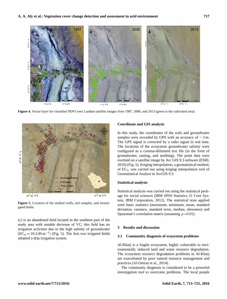
180 groundwater samples were gathered from different lo-
cations in the Al-Kharj AE to cover the spatial variations
of the ecosystem groundwater salinity (Fig. 5). All samples
were analyzed for salinity using an electrical conductivity
(EC) meter (dS×m−1) (test kit model 1500_20, Cole and
Parmer) at 25 ◦C. The groundwater soluble calcium, mag-
nesium, sodium, potassium, chloride, and sulfate were de-
termined using an ion chromatography system (ICS 5000,
Thermo, USA); however, the bicarbonate and carbonate con-
centration were determined by titration with sulfuric acid
(H2SO4) (Matiti, 2004). Furthermore, 50 soil samples were
collected from the studied area including deteriorated sites
observed by satellite images for the year 2013 (ground truth).
A soil paste extract was prepared, and the ECe was measured
for each sample (Klute, 1986). In addition, 5TE (Decagon
devices) soil moisture, EC, and temperature sensors were in-
stalled at three date palm fields in the Al Kharj AE. The
first field (a) is located in the eastern part of the study area
with no change of VC and used fresh water for irrigation
(ECw= 1.1 dS m−1). The second (b) is a deteriorated field
located in the middle to the western part and used saline
brackish water for irrigation (ECw= 6.5 dS m−1). The third
Solid Earth, 7, 713–725, 2016 www.solid-earth.net/7/713/2016/
A. A. Aly et al.: Vegetation cover change detection and assessment in arid environment 717
Figure 4. Vector layer for classified NDVI over Landsat satellite images from 1987, 2000, and 2013 (green is the cultivated area).
Figure 5. Location of the studied wells, soil samples, and investi-
gated fields.
(c) is an abandoned field located in the southern part of the
study area with notable decrease of VC; this field has no
irrigation activities due to the high salinity of groundwater
(ECw= 10.2 dS m−1) (Fig. 5). The first two irrigated fields
adopted a drip irrigation system.
Coordinate and GIS analysis
In this study, the coordinates of the soils and groundwater
samples were recorded by GPS with an accuracy of ∼ 5 m.
The GPS signal is corrected by a radio signal in real time.
The locations of the ecosystem groundwater salinity were
configured as a comma-delimited text file (in the form of
groundwater, easting, and northing). The point data were
overlaid on a satellite image by Arc GIS 9.3 software (ESRI,
2010) (Fig. 5). Kriging interpolation, a geostatistical method,
of ECw was carried out using kriging interpolation tool of
Geostatistical Analyst in ArcGIS 9.3.
Statistical analysis
Statistical analysis was carried out using the statistical pack-
age for social sciences (IBM SPSS Statistics 21 Core Sys-
tem, IBM Corporation, 2012). The statistical tests applied
were basic statistics (maximum, minimum, mean, standard
deviation, variance, standard error, median, skewness) and
Spearman’s correlation matrix (assuming p<0.01).
3 Results and discussion
3.1 Community diagnosis of ecosystem problems
Al-Kharj is a fragile ecosystem, highly vulnerable to envi-
ronmentally induced land and water resource degradation.
The ecosystem resource degradation problems in Al-Kharj
are exacerbated by poor natural resource management and
practices (Al-Omran et al., 2014).
The community diagnosis is considered to be a powerful
investigation tool to overcome problems. The local people
www.solid-earth.net/7/713/2016/ Solid Earth, 7, 713–725, 2016
718 A. A. Aly et al.: Vegetation cover change detection and assessment in arid environment
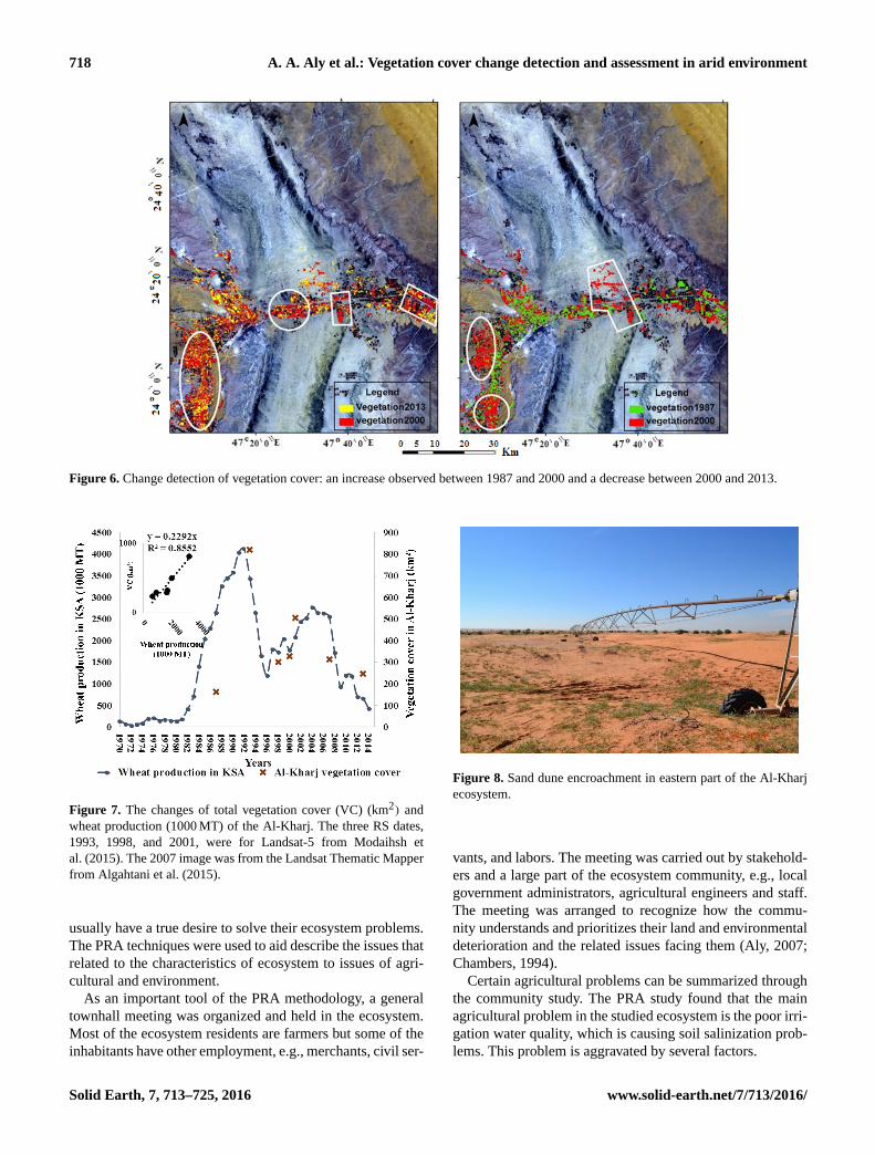
Figure 6. Change detection of vegetation cover: an increase observed between 1987 and 2000 and a decrease between 2000 and 2013.
Figure 7. The changes of total vegetation cover (VC) (km2) and
wheat production (1000 MT) of the Al-Kharj. The three RS dates,
1993, 1998, and 2001, were for Landsat-5 from Modaihsh et
al. (2015). The 2007 image was from the Landsat Thematic Mapper
from Algahtani et al. (2015).
usually have a true desire to solve their ecosystem problems.
The PRA techniques were used to aid describe the issues that
related to the characteristics of ecosystem to issues of agri-
cultural and environment.
As an important tool of the PRA methodology, a general
townhall meeting was organized and held in the ecosystem.
Most of the ecosystem residents are farmers but some of the
inhabitants have other employment, e.g., merchants, civil ser-
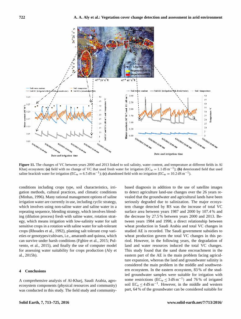
Figure 8. Sand dune encroachment in eastern part of the Al-Kharj
ecosystem.
vants, and labors. The meeting was carried out by stakehold-
ers and a large part of the ecosystem community, e.g., local
government administrators, agricultural engineers and staff.
The meeting was arranged to recognize how the commu-
nity understands and prioritizes their land and environmental
deterioration and the related issues facing them (Aly, 2007;
Chambers, 1994).
Certain agricultural problems can be summarized through
the community study. The PRA study found that the main
agricultural problem in the studied ecosystem is the poor irri-
gation water quality, which is causing soil salinization prob-
lems. This problem is aggravated by several factors.
Solid Earth, 7, 713–725, 2016 www.solid-earth.net/7/713/2016/
A. A. Aly et al.: Vegetation cover change detection and assessment in arid environment 719
– The number of new wells that were recently drilled for
irrigation has increased dramatically, causing depletion
and deterioration of groundwater quality (Al-Omran et
al., 2015; Aly et al., 2016).
– Poor irrigation is practised in the Al-Kharj (excessive
irrigation system). The same finding was recorded in
Siwa AE, located in an Egyptian arid environment, by
Aly et al. (2016). No agricultural drainage system in the
Al-Kharj. Thus in some areas, the Al-Kharj could face
the danger of water logging and salinization problems
(Aly et al., 2016).
– Large investments in intensive cultivation, which culti-
vates hundreds of acres and drills tens of new wells, are
causing great damage to the fragile ecosystem of the Al-
Kharj (Algahtani et al., 2015; Aly, 2007; Sonneveld et
al., 2016).
– In summer there is no agriculture activity due to high
temperature (reached 50 ◦C) with the exception of pro-
tected areas (Tourenq et al., 2009).
– Some farmers use desalination plants to overcome the
irrigation water salinity (Al-Omran et al., 2014).
– Biodiversity loss is due to soil salinity. This is expected
since salinization is the most common land degradation
processes in arid and semi-arid regions (Farifteh et al.,
2006)
– Farmers in Al-Kharj usually change their soils when de-
teriorated (Richardson et al., 2010).
– Agricultural labor is rare and highly costly.
All the above mentioned agricultural issues and problems
lead to a significant decrease in land productivity of the stud-
ied agro-ecosystem.
3.2 Remote sensing: direction changes of vegetation
cover
The major change detected in the study area between years
1987 and 2000 was the increase of total VC in the west-
ern and southwestern parts of Al-Kharj ecosystem (Fig. 6).
However, the total VC decreased between years 2000 and
2013 in the eastern and southwestern parts of Al-Kharj AE
(Fig. 6). The investigation of the three satellite images con-
cluded that the surface area in square kilometers of the to-
tal VC increased dramatically between years 1987 and 2000
by 107.4 %; however, it decreased by 27.5 % between years
2000 and 2013 (Table 1) (Fichera et al., 2012). In an at-
tempt to explicate the reason for the ecosystem’s total VC
decrease in the last decade, a relationship between total VC
and wheat production has been depicted. Figure 7 shows a di-
rect relationship between wheat production in Saudi Arabia
(USDA, 2015) and total VC in Al-Kharj AE. Furthermore, it
Figure 9. Interpolation of groundwater EC.
recorded evidence of progressive increase of wheat produc-
tion and total VC during the period of 1984–1993 (Algah-
tani et al., 2015; Modaihsh et al., 2015; USDA, 2015). This
was caused by the economic development that corresponds
to the period of massive injection of subsidies that came with
the government’s policy to expand the wheat production over
this period (USDA, 2015). Rationally, this has led to a steady
increase in the land area used by vegetation. However, there
was a nosedive during the period of 1994–1998 due to the
Saudi government stopping subsidies of wheat production
to save water. A slight increase of total VC was recorded
between years 1998 and 2002, and a contentious decrease
was seen between years 2002 and 2013. This study suggests
that the decrease in the last decade of total VC was caused
by land and water resources degradation (Sonneveld et al.,
2016). This suggestion have been emphasized by field stud-
ies through PRA method and is in agreement with the find-
ings of Algahtani et al. (2015).
3.3 Soil and water resources characteristics and its
effects in agro-ecosystem
The field study and observation, the review of secondary
data, and community problem diagnosis using the PRA sug-
gest that the driving force in the change of total VC recorded
by RS in recent years are the soil and water resources deterio-
ration and salinization. The ground truth found that the dete-
riorated soils are either subjected to salinization or sand dune
encroachment (Figs. 8, 9, and 10) (Al Omran et al., 2015;
Alyemeni, 2000). In general, the sand dune in the eastern
part of the studied AE is considered the main problem facing
agriculture expansion; however, the groundwater salinity is
considered the main problem of southwestern part (Figs. 8,
9, and 10) (Al Omran et al., 2015).
Table 2 shows that in the eastern part of the ecosystem,
83 % of groundwater samples were suitable for irrigation
www.solid-earth.net/7/713/2016/ Solid Earth, 7, 713–725, 2016

720 A. A. Aly et al.: Vegetation cover change detection and assessment in arid environment
Table 1. Spatiotemporal characteristics of Al-Kharj ecosystem.
Reference Classified Vegetation cover areas (km2)
year image
Dense Moderate Sparse Total
(NDVI > 0.5) (NDVI= 0.25–0.5) (NDVI < 0.25)
1987 Landsat4 36 69 58 163
TM
2000 Landsat7 8 156 174 338
ETM+
2013 Landsat8 6 91 148 245
Table 2. Water and soil-deteriorated parameter (salinity) in relation
to total VC area.
ECw ECe
≤ 3 3–4 4–10 ≤ 4 4–10 > 10
Eastern % of samples 83 17 – 76 18 5
ecosystem Total VC %
decrease 18
(2000–2013)
Middle and % of samples 64 20 16 19 50 31
western Total VC %
ecosystem decrease 33
(2000–2013)
with some restriction (ECw≤ 3 dS m−1) (Ayers and Westcot,
1985); however, the remaining their ECw ranged between 3
and 4 dS m−1 (Table 2). In response to irrigation water salin-
ity, 76 % of irrigated soil ECe≤ 4 dS m−1, 18 % ECe ranged
between 4 and 10 dS m−1, and 5 % soil ECe > 10 dS m−1.
Nonetheless, the total VC area decreased by 18 % between
years 2000 and 2013. In the middle and western part, the
ecosystem showed more vulnerable soil conditions for soil
degradation. Only 64 % of the groundwater can be con-
sidered suitable for irrigation (ECw≤ 3 dS m−1). However,
20 % of groundwater samples ECw ranged between 3 and
4 dS m−1, and 16 % of the ECw ranged between 4 and
10 dS m−1. As a result, only 19 % of the studied soil sam-
ples ECe≤ 4 dS m−1, 50 % ECe between 4 and 10 dS m−1,
and regrettably 31 % ECe > 10 dS m−1. The total VC then
decreased dramatically in this part by 33 % between years
2000 and 2013. The highest soil ECe in the eastern part of
the studied ecosystem was 17.6 dS m−1 (sample no. 1), but in
the middle part of the ecosystem deteriorated sites recorded
40.6 and 47.4 dS m−1 for sample nos. 17 and 18, respec-
tively (Table 3 and Fig. 10). Moreover, the soil salinity dra-
matically increased in some sites of the western ecosystem,
reaching 41.7 dS m−1 (site no. 29) (Figs. 6, 10). The ground-
water in the western part of the studied ecosystem is con-
sidered highly saline since its salinity is almost more than
6 dS m−1 (Fig. 9). Mostly, no soil sodium hazards are antic-
Table 3. Descriptive statistics of EC (dS m−1) of soil (n= 50) and
water samples (n= 180) in ecosystem areas subjected to sand dune
encroachment (eastern part) or salinization (middle and western
part).
Soil Water
Eastern part Middle and Eastern part Middle and
western part western part
Max. 17.63 47.35 3.82 10.15
Min. 2.50 2.34 1.31 1.83
Mean 3.05 12.11 2.50 3.22
Med.1 2.66 7.12 2.54 2.73
SD2 7.51 12.01 0.71 1.42
1 Med. is the median; 2 SD is the standard deviation.
ipated by using this type of groundwater in irrigation. The
sodium adsorption ratio of studied water samples were less
than 10 with an average of 3.74 (Table 4) (Richards, 1954).
In general, 34.8 % of the arable land in the studied AE is
considered saline (ECe > 4 dS m−1), 34.8 % is severely saline
(ECe > 10 dS m−1), and the remaining (30.4 %) can be con-
sidered non-saline (ECe < 4 dS m−1). The ECe of Al-Kharj
cultivated soils ranged between 1 and 47.4 dS m−1 for non-
deteriorated and deteriorated sites, respectively; however, the
uncultivated soil ECe reached 140 dS m−1 in western AE.
3.4 Total VC degradation and land and water resource
salinity
In order to prove that the land and water resource salinity of
past 10 years are the main cause of total VC decrease in the
ecosystem, the changes of total VC have been linked to wa-
ter and soil salinity levels at three different fields (Figs. 5,
11). The soil parameters (soil moisture, EC, and tempera-
ture) were recorded at investigated fields by sensors. The av-
erage values of the soil parameters of four date palms at depth
(0–30 cm) for each field were presented in Fig. 11. The sen-
sors in abandoned field did not work properly due to the low
soil water content (∼ 0.01 m3 m−3) where the precipitation
is negligible (Gao et al., 2014; Saha et al., 2015). The re-
Solid Earth, 7, 713–725, 2016 www.solid-earth.net/7/713/2016/

A. A. Aly et al.: Vegetation cover change detection and assessment in arid environment 721
Table 4. Statistical analysis of groundwater chemical composition of Al-Kharj (n= 180).
PH EC Ca2+ Mg2+ Na+ K+ Cl− HCO−3
CO−23
SO−24
Sodium
dS m−1 meq L−1 adsorption
ratio
Max. 8.60 10.15 36.75 29.85 43.40 0.72 58.17 18.83 4.33 43.19 9.14
Min. 6.78 1.05 3.45 0.79 2.24 0.05 3.13 0.87 0.00 3.22 1.08
Mean 7.72 3.00 10.79 7.78 11.28 0.25 10.86 3.99 0.13 15.03 3.74
SD 0.44 1.29 5.09 3.93 5.96 0.10 7.32 1.49 0.37 7.05 1.47
Vari.1 0.66 1.13 2.26 1.98 2.44 0.31 2.71 1.22 0.61 2.66 1.21
St. error2 0.18 0.23 0.33 0.31 0.34 0.12 0.36 0.24 0.17 0.36 0.24
Med. 7.72 2.64 9.60 6.69 10.21 0.23 9.50 3.83 0.00 12.83 3.51
Skew.3 −0.15 2.47 1.39 2.16 2.53 1.66 3.85 5.96 8.20 1.18 1.12
1 Vari. is the variance; 2 st. error is the standard error; 3 skew. is the skewness.
sults indicated that the irrigation with low water salinity in
the first field did not lead to high soil salinity values (aver-
age soil EC= 1.25 dS m−1) (Fig. 11). The leaching process
led to the soil salinity to get lower with adding irrigation.
However, the irrigation with saline water in the second field
led to soil quality deterioration due to salinity (average soil
salinity was equal to 6.7 dS m−1) (Fig. 11). The soil in the
abandoned field is suffering from severe salinity (averaged
39.2 dS m−1) due to lack of irrigation and the low precipi-
tation. Subsequently, soluble salts have accumulated in the
top soil layer, thus negatively impacting total VC water up-
take and growth due to low tolerance of the total VC to very
high salinity. These are expected results as salinization and
alkalinization are the most common land degradation pro-
cesses in arid and semi-arid regions (Farifteh et al., 2006).
Since the temperature of Al Kharj reaches 45 ◦C in July, the
soil temperature was also investigated in this study. Figure 11
clearly demonstrates that the summer irrigation led to a dra-
matic decrease of soil temperature (up to 5 ◦C). During the ir-
rigation, the air is replaced with water leading to the decrease
in soil temperature. In contrast, following the irrigation, the
water drains and air fills up the soil pores and the soil tem-
perature gets higher (Fig. 11) (USAD, 2002). Comparing the
three sites of total VC, it is clear that the high salinity of the
land caused by high salinity of groundwater resources had a
negative impact on vegetation survival, especially in the ab-
sence of salt leaching by rainfall or fresh irrigation water.
In addition, the sand dune encroachment represents another
cause of the total VC decrease in the eastern part of the study
sites (Fig. 8). The farmers of Al-Kharj should be informed
about the water quality of their wells and should be given
advice by the extension services about the type of suitable
crops and management that would safeguard the Al-Kharj
ecosystem. The government should take action to solve the
problem of sand dune encroachment in the eastern part of
the ecosystem and help farmers select salinity-tolerant crops
that can survive such conditions. Sand dune fixation is gen-
erally used to stop the dunes encroachment. Two methods
Figure 10. Salinity of selected soil samples (n= 33).
are usually used: biological (i.e., planting trees, shrubs, and
grass species) and mechanical (i.e., wooden sand fences and
footpaths). Shelter-belt systems and afforestation, biological
methods, using Atriplex spp., Acacia spp., and Casuarina
spp. were found to be efficient in stabilizing dunes in arid en-
vironments of Egypt, Senegal, and India (Draz et al., 1992;
Kaul, 1985). In fact, the importance of the sand dunes fixa-
tion by afforestation is not only sand dune fixation but also
can conserve arid ecosystem balance and produce fuel and
animal feed (Draz et al., 1992; Kaul, 1985).
Saline waters have been successfully used for a long ir-
rigation time in the USA, Tunisia, and Egypt. The crops
irrigated with this water are cotton, sugar beet, alfalfa,
date palm, sorghum, barley, alfalfa, rye grass, and artichoke
(Rhoades et al., 1992). In Texas, USA, the saline ground-
water (TDS= 2500 to 6000 mg L−1) has been used for 3
decades (Rhoades et al., 1992). The suitability of saline
groundwater for irrigation should be assessed for specific
www.solid-earth.net/7/713/2016/ Solid Earth, 7, 713–725, 2016
722 A. A. Aly et al.: Vegetation cover change detection and assessment in arid environment
Figure 11. The changes of VC between years 2000 and 2013 linked to soil salinity, water content, and temperature at different fields in Al
Kharj ecosystem: (a) field with no change of VC that used fresh water for irrigation (ECw = 1.1 dS m−1); (b) deteriorated field that used
saline brackish water for irrigation (ECw = 6.5 dS m−1); (c) abandoned field with no irrigation (ECw = 10.2 dS m−1).
conditions including crops type, soil characteristics, irri-
gation methods, cultural practices, and climatic conditions
(Minhas, 1996). Many rational management options of saline
irrigation water are currently in use, including cyclic strategy,
which involves using non-saline water and saline water in a
repeating sequence, blending strategy, which involves blend-
ing (dilution process) fresh with saline water, rotation strat-
egy, which means irrigation with low-salinity water for salt
sensitive crops in a rotation with saline water for salt-tolerant
crops (Rhoades et al., 1992), planting salt tolerant crop vari-
eties or genotypes/cultivars, i.e., amaranth and quinoa, which
can survive under harsh conditions (Fghire et al., 2015; Pul-
vento, et al., 2015), and finally the use of computer model
for assessing water suitability for crops production (Aly et
al., 2015b).
4 Conclusions
A comprehensive analysis of Al-Kharj, Saudi Arabia, agro-
ecosystem components (physical resources and community)
was conducted in this study. The field study and community-
based diagnosis in addition to the use of satellite images
to detect agriculture land-use changes over the 26 years re-
vealed that the groundwater and agricultural lands have been
seriously degraded due to salinization. The major ecosys-
tem change detected by RS was the increase of total VC
surface area between years 1987 and 2000 by 107.4 % and
the decrease by 27.5 % between years 2000 and 2013. Be-
tween years 1984 and 1998, a direct relationship between
wheat production in Saudi Arabia and total VC changes in
studied AE is recorded. The Saudi government subsidies to
wheat production govern the total VC changes in this pe-
riod. However, in the following years, the degradation of
land and water resources induced the total VC changes.
This study found that the sand dune encroachment in the
eastern part of the AE is the main problem facing agricul-
ture expansion, whereas the land and groundwater salinity is
considered the main problem in the middle and southwest-
ern ecosystem. In the eastern ecosystem, 83 % of the stud-
ied groundwater samples were suitable for irrigation with
some restrictions (ECw≤ 3 dS m−1) and 76 % of irrigated
soil ECe≤ 4 dS m−1. However, in the middle and western
part, 64 % of the groundwater can be considered suitable for
Solid Earth, 7, 713–725, 2016 www.solid-earth.net/7/713/2016/
A. A. Aly et al.: Vegetation cover change detection and assessment in arid environment 723
irrigation (ECw≤ 3 dS m−1), and only 19 % of the studied
soil samples had ECe≤ 4 dS m−1. The farmers of Al-Kharj
should be informed about the water quality of their wells and
should be given advice by the extension services about the
type of suitable crops and management that would safeguard
the Al-Kharj ecosystem.
List of abbreviations
EM is ecosystem management; RS is remote sensing; GIS is
geographic information systems; GPS is global positioning
system, LC is land cover; LU is land use; VC is vegetation
cover; AE is agro-ecosystem; PRA is participatory rural ap-
praisal; ECw is electrical conductivity measured on ground-
water samples; ECe is electrical conductivity measured on
soil samples using saturated paste extracts.
The Supplement related to this article is available online
at doi:10.5194/se-7-713-2016-supplement.
Acknowledgements. This project was supported by NSTIP strategic
technologies program number 12-ENV2581-02 in the Kingdom of
Saudi Arabia.
Edited by: A. Cerdà
References
Algahtani, O. S., Salama, A. S., Iliyasu, A. M., Selim, B. A., and
Kheder, K.: Monitoring urban and land use changes in Al-Kharj
Saudi Arabia using remote sensing techniques. Progress in sys-
tems engineering: Proceedings of the twenty-third international
conference on systems engineering, Advances in Intelligent Sys-
tems and Computing 1089, Springer International Publishing
Switzerland 2015, 75, 515–523, 2015.
Al-Harbi, M. A.: Effect of Cultivation Periods on Pedological Char-
acteristics of some Soils in Harrad and Al-Kharj, M. Sc. The-
sis, Soil Science Department, College of Agriculture, King Saud
University, Saudi Arabia, 2005.
Almeida, C. M., Monteiro, A. M. V., Mara, G., Soares-Filho, B.
S., Cerquera, G. C., Pennachin, C. S. L., and Batty, M.: GIS
and remote sensing as tools for the simulation of urban land-use
change, Int. J. Remote Sens., 26, 759–774, 2005.
Al-Omran, A. M., Louki, I. I., Aly, A. A., and Nadeem, M. E.: Im-
pact of Deficit Irrigation on Soil Salinity and Cucumber Yield un-
der greenhouse condition in arid environment, J. Agr. Sci. Tech-
nol., 15, 1247–1259, 2013.
Al-Omran, A. M., Aly, A., and Sallam, A.: A Holistic Ecosys-
tem Approach for the Sustainable Development of Fragile Agro-
ecosystems: A case study of the Al-Kharj Ecosystem, Saudi
Arabia. National Science, Technology and Innovation Plan,
Kingdom of Saudi Arabia, for financial support of project 12-
ENV2581-02, 2014.
Al-Omran, A. M., Aly, A. A., Al-Wabel, I. M., Sallam, A. S., and
Al-Shayaa, M. S.: Hydrochemical Characterization of Ground-
water under Agricultural Land in Arid Environment: a Case
Study of Al-Kharj, Saudi Arabia, Arab. J. Geosci., 9, 9–15, 2015.
Aly, A. A.: A Holistic Ecosystem Approach for Sustainable Man-
agement of Land and Water Resources in Siwa Oasis. PhD The-
sis, Faculty of Agriculture, Alexandria University, Egypt, 2007.
Aly, A. A., Al-Omran, A. M., and Alharby, M. M.: The water qual-
ity index and hydrochemical characterization of groundwater re-
sources in Hafar Albatin, Saudi Arabia, Arab. J. Geosci., 8, 4–5,
2015a.
Aly, A. A., Al-Omran, A. M., and Khasha, A.: Water management
for cucumber: Greenhouse experiment in Saudi Arabia and mod-
eling study using SALTMED model, J. Soil Water Conserv., 70,
1–11, 2015b.
Aly, A. A., Kishk, F. M., Gaber, H. M., and Al-Omran, A. M.: Long-
term detection and hydrochemistry of groundwater resources in
Egypt: Case study of Siwa Oasis, J. Saudi Soc. Agr. Sci., 15,
67–74, 2016.
Alyemeni, M. N.: Ecological Studies on Sand dunes Vegetation in
AI-Kharj region, Saudi Arabia, Saudi J. Biol. Sci., 7, 64–87,
2000.
Ayers, A. S. and Westcot, D. W.: Water Quality for Agriculture, Ir-
rigation and Drainage Paper 29 (Rev.1), FAO, Rome, Italy, 1985.
Berendse, F., van Ruijven, J., Jongejans, E., and Keesstra, S. D.:
Loss of plant species diversity reduces soil erosion resistance of
embankments that are crucial for the safety of human societies in
low-lying areas, Ecosystems, 18, 881–888, 2015.
Bochet, E.: The fate of seeds in the soil: a review of the influence
of overland flow on seed removal and its consequences for the
vegetation of arid and semiarid patchy ecosystems, Soil, 1, 131–
146, 2015.
Brevik, E. C., Cerdà, A., Mataix-Solera, J., Pereg, L., Quinton, J.
N., Six, J., and Van Oost, K.: The interdisciplinary nature of Soil,
Soil, 1, 117–129, 2015.
Brodt, S., Six, J., Feenstra, G., Ingels, C., and Camp-
bell, D.: Sustainable Agriculture, Nature Education Knowl-
edge, 2, available at: http://www.nature.com/scitable/knowledge/
library/sustainable-agriculture-23562787 (last access: 11 March
2015), 2011.
Cerdà, A.: Parent material and vegetation affect soil erosion in east-
ern Spain, Soil Sci. Soc. Am. J., 63, 362–368, 1999.
Cerdà, A. and Doerr, S. H.: Influence of vegetation recovery on soil
hydrology and erodibility following fire: An 11-year investiga-
tion, Int. J. Wildland Fire, 14, 423–437, 2005.
Chambers, R.: Participatory Rural Appraisal (PRA): Analysis of
Experience, World Dev., 22, 1253–1268, 1994.
Chowdary, V. M., Paul, S., Kumar, T., Sudhakar, S., and Adiga, S.:
Remote sensing and GIS approach for watershed monitoring and
Asian Conference on Remote Sensing, 5–9 November 2001, Sin-
gapore, 2, 802–807, 2001.
Croft, H., Kuhn, N. J., and Anderson, K.: On the use of remote sens-
ing techniques for monitoring spatio-temporal soil organic car-
bon dynamics in agricultural systems, Catena, 94, 64–74, 2012.
Dagci, M. and Kusek, G.: Monitoring microcatchment by using
satellite imagery: Kiziloz sample, in: Integration of information
for environmental security, edited by: Coskun, H. G., Cigizoglu,
H. K., and Makktav, D., Springer, 175–189, 2008.
www.solid-earth.net/7/713/2016/ Solid Earth, 7, 713–725, 2016
724 A. A. Aly et al.: Vegetation cover change detection and assessment in arid environment
Debolini, M., Schoorl, J. M., Temme, A., Galli, M., and Bonari,
E.: Changes in Agricultural Land Use Affecting Future Soil Re-
distribution Patterns: A Case Study in Southern Tuscany (Italy),
Land Degrad. Dev., 26, 574–586, 2015.
Desprats, J. F., Al-Omran, A. M., and Desmartis, B.: Harrats project
– Evaluation of water requirement for irrigated agriculture with
remote sensing, BRGM/RP-63531-FR, p. 45, 2014.
Draz, M. Y., Ahmed, A. M., and Afify, M. Y.: Studies on sand en-
croachment in Siwa Oasis, Western desert, Egypt, II – Feasibility
of sand dune fixation measures, J. Eng. and Appl. Sci., 39, 723–
725, 1992.
Ehlers, M., Edwards, G., and Bedard, Y.: Integration of remote sens-
ing with geographic information system: A necessary evolution,
Photogramm. Eng. Rem. S., 55, 1619–1627, 1989.
EL-Bana, T. A.: Agro-ecological assessment of land and water re-
sources Norther Nile delta: A case study in kafr EL-Sheikh gov-
ernorate: M.Sc. Thesis, Fac. Of Agric., Alex. Univ., Egypt, 2003.
ESRI: Arc View version 10 user manual, Redlands, CA, USA, 2010.
Farifteh, J., Farshad, A., and George, R. J.: Assessing salt-affected
soils using remote sensing, solute modelling, and geophysics,
Geoderma, 130, 191–206, 2006.
Fghire, R., Wahb, S., Anaya, F., Ali, O., Benlhabib, O., and Ragab,
R.: Response of quinoa to different water management strategies:
field experiments and saltmed model application results, Irrig.
Drain., 64, 29–40, 2015.
Fichera, C. R., Modica, G., and Pollino, M.: Land Cover classifica-
tion and change-detection analysis using multi-temporal remote
sensed imagery and landscape metrics, Eur. J. Remote Sens., 45,
1–18, 2012.
Gao, J.: Integration of GPS with Remote Sensing and GIs: Reality
and Prospect, Photogramm. Eng. Rem. S., 68, 447–453, 2002.
Gao, X., Wu, P., Zhao, X., Wang, J., and Shi, Y.: Effects of land use
on soil moisture variations in a semi-arid catchment: Implica-
tions for land and agricultural water management, Land Degrad.
Dev., 25, 163–172, 2014.
GeoMart.: Understanding Color Infrared (CIR) Aerial Photog-
raphy, available at: http://www.geomart.com/products/aerial/cir.
htm, last access: 28 June 2011.
Gong, Z., Kawamura1, K., Ishikawa, N., Goto, M., Wulan, T.,
Alateng, D., Yin, T., and Ito, Y.: MODIS normalized differ-
ence vegetation index (NDVI) and vegetation phenology dynam-
ics in the Inner Mongolia grassland, Solid Earth, 6, 1185–1194,
doi:10.5194/se-6-1185-2015, 2015.
Hagras, M. A., Elmoustafa, A. M., and Ahmed, K.: Flood plain mit-
igation in arid regions case study: South of Al-Kharj city, Saudi
Arabia, IJRRAS, 16, 147–156, 2013.
Hinto, J. C.: GIs and remote sensing integration for environmental
applications, Int. J. Geogr. Inf. Syst., 10, 877–890, 1996.
Jenny, H.: The soil resource origin and behavior, Springer Verlag,
New York, 1962.
Kaul, R. N.: A forestation of dune area, in: Sand dune stabilization,
shelterbelts and afforestation in the dry zones, FAO Conservation
Gudie, 10, 75–85, 1985.
Keesstra, S. D., Geissen, V., van Schaik, L., Mosse, K., and Piira-
nen, S.: Soil as a filter for groundwater quality, Curr. Opin. Env-
iron. Sust., 4, 507–516, 2012.
Klute, A.: Methods of soil analysis, Part 1. 2nd Edn., Agron Monor.
9. ASA and SSSA, Madison, WI, 1986.
Leh, M., Bajwa, S., and Chaubey, I.: Impact of land use change on
erosion risk: and integrated remote sensing geopraphic informa-
tion system and modeling methodology, Land Degrad. Dev., 24,
409–421, 2013.
Lucas, R., Rowlands, A., Brown, A., Keyworth, S., and Bunting, P.:
Rule-based classification of multi-temporal satellite imagery for
habitat and agricultural land cover mapping, ISPRS J. P. Remote
Sens., 62, 165–185, 2007.
Maltby, E.: Ecosystem approach: From principle to practice Ecosys-
tem Service and Sustainable Watershed Management in North
China, International Conference, Beijing, P.R. China, 205–224,
2000.
Matiti, S. K.: Handbook of methods in environmental studies: water
and wastewater analysis ABD Publishers, Jaipur (India), 2004.
McLaren, S. J., Al-Juaidi, F., Bateman, M. D., and Millington, A.
C.: First evidence for episodic flooding events in the arid interior
of central Saudi Arabia over the last 60 ka, J. Quaternary Sci.,
24, 198–207, 2008.
Mikkelson, B.: Methods for development work and research: A
guide for practitioners, New Delhi/Thousand oaks/London, Saga
Publications, 1994.
Minhas, P. S.: Saline water management for irrigation in India, Agr.
Water Manag., 30, 1–24, 1996.
Modaihsh, A. S., Mahjoub, M. O., Sallam, A. S., and Ghoneim,
A. M.: Evaluation of soil degradation in Al-Kharj center, Saudi
Arabia using remote sensing, Int. J. Remote Sens. Geosci., 4, 2–
7, 2015.
Mohawesh, Y., Taimeh, A., and Ziadat, F.: Effects of land use
changes and soil conservation intervention on soil properties as
indicators for land degradation under a Mediterranean climate,
Solid Earth, 6, 857–868, doi:10.5194/se-6-857-2015, 2015.
Muñoz-Rojas, M., Jordán, A., Zavala, L. M., De la Rosa, D., Abd-
Elmabod, S. K., and Anaya-Romero, M.: Impact of Land Use
and Land Cover Changes on Organic Carbon Stocks in Mediter-
ranean Soils (1956–2007), Land Degrad. Dev., 26, 168–179,
2015.
Mushove, P. and Vogel, C.: Heads or tails? Stakeholder analysis as a
tool for conservation area management, Global Environ. Chang.,
15, 184–198, 2005.
Pulvento, C., Lavini, A., Riccardi, M., Andria, R. D., and Ragab,
R.: Assessing Amaranth Adaptability in a Mediterranean Area
of South Italy under Different Climatic Scenarios, Irrig. Drain.,
64, 50–58, 2015.
Rawat, J. S., Biswas, V., and Kumar, M.: Changes in land use/cover
using geospatial techniques: A case study of Ramnagar town
area, district Nainital, Uttarakhand, India, Egypt, J. R. S. Space
Sci., 16, 111–117, 2013.
Reed, M. S., Graves, A., Dandy, N., Posthumus, H., Hubacek, K.,
Morris, J., Prell, C., Quinn, C. H., and Stinger, L. C.: Who’s in
and why? A typology of stakeholder analysis methods for natural
resource management, J. Environ. Manag., 90, 1933–1949, 2009.
Rhoades, D., Kandiah, A., and Mashali, A. M.: The use of saline
waters for crop production, Irrig. Drain., 48, 11-98, 1992.
Richards, L. A. (Ed.): Diagnosis and improvement of saline and
alkali soils, USDA Hand book, 60, 4–80, 1954.
Richardson, P. J., Lundholm J. T., and Larson D. W.: Natural ana-
logues of degraded ecosystems enhance conservation and recon-
struction in extreme environments, Ecol. Appl., 20, 728–740,
2010.
Solid Earth, 7, 713–725, 2016 www.solid-earth.net/7/713/2016/

A. A. Aly et al.: Vegetation cover change detection and assessment in arid environment 725
Saha, D. and Kukal, S. S.: Soil structural stability and water reten-
tion characteristics under different land uses of degraded lower
himalayas of North-West India, Land Degrad. Dev., 26, 263–271,
2015.
Seelan, K. S., Laguette, S., Casady, G. M., and Seielstad, G. A.:
Remote sensing applications for precision agriculture: A learn-
ing community approach, Remote Sens. Environ., 88, 157–169,
2003.
Setiawan, Y. and Yoshino, K.: Change detection inland-use and
land-cover dynamics at a regional scale from modis time-series
imagery, ISPRS Annals of the Photogrammetry, Remote Sensing
and Spatial Information Sciences, Volume I-7, 2012 XXII ISPRS
Congress, 25 August–1 September 2012, Melbourne, Australia,
2012.
Shepherd, G. (Ed.).: The Ecosystem Approach: Learning from Ex-
perience. International Union for Conservation of Nature and
Natural Resources, Gland, Switzerland, 2008.
Singh, B. G.: Detection of land use and land cover change with
Remote Sensing and GIS: A case study of Punjab Siwaliks, Int.
J. Geom. Geosci., 4, 296–304, 2013.
Sonneveld, B. G., Keyzer, M. A., and Ndiaye, D.: Quantifying the
impact of land degradation on crop production: the case of Sene-
gal, Solid Earth, 7, 93–103, doi:10.5194/se-7-93-2016, 2016.
Suliman, A. S.: Change detection from satellite images in Nile Delta
Coastal, Egypt, Alexandria Journal of Agriculture Research, 46,
177–188, 2001.
Swallow, B. M., Kallesoe, M. F., Iftikhar, U. A., Van Noordwijk,
M., Bracer, C., Scherr, S. J., Raju, K. V., Poats, S. V., Kumar Du-
raiappah, A., Ochieng, B. O., Mallee, H., and Rumley, R.: Com-
pensation and rewards for environmental services in the develop-
ing world: framing pan-tropical analysis and comparison, Ecol.
Soc., 14, 26–30, 2009.
Tourenq, C., Khassim, A., Sawaf, M., Shuriqi, M. K., Smart, E.,
Ziokowski, M., Brook, M., Wan, R. S., and Perry, L.: Characteri-
sation of the Wadi Wurayah Catchment Basin, the First Mountain
Protected Area in the United Arab Emirates, Int. J. Ecol. Environ.
Sci., 35, 289–311, 2009.
Trabaquini, K., Formaggio, A. R., and Galvão, L. S.: Changes in
physical properties of soils with land use time in the Brazilian
savanna environment, Land Degrad. Dev., 26, 397–408, 2015.
United States Department of Agriculture (USDA): Saudi
Arabia Wheat Production by Year, available at: http:
//www.indexmundi.com/agriculture/?country=sa&commodity=
wheat&graph=production, last access: April 2016.
USDA: The temperature regime for selected soils in the United
States. Soil survey investigations, report no. 48, National soil sur-
vey center, Lincoln, Nebraska, 2002.
Vrieling, A.: Satellite remote sensing for water erosion assessment:
A review, Catena, 65, 2–18, 2006.
Xie, Y., Sha, Z., and Yu, M.: Remote sensing imagery in vegetation
mapping: a review, J. Plant Ecol., 1, 9–23, 2008.
Yang, X., Damen, M. C. J., and van Zuidam, R. A.: Satellite remote
sensing and GIS for the analysis of channel migration changes
in the active Yellow River Delta, China. J. Aquat. Geol., 1, 146–
157, 1999.
Yu, Y. and Jia, Z. Q.: Changes in soil organic carbon and nitro-
gen capacities of Salix cheilophila Schneid along a revegetation
chronosequence in semi-arid degraded sandy land of the Gonghe
Basin, Tibet Plateau, Solid Earth, 5, 1045–1054, doi:10.5194/se-
5-1045-2014, 2014.
Yuan, F., Sawaya, K. E., Loeffelholz, B. C., and Bauer, M. E.:
Land cover classification and change analysis of the Twin Cities
(Minnesota) Metropolitan Area by multitemporal Landsat re-
mote sensing, Remote Sens. Environ., 98, 317–328, 2005
Zucca, C., Wu, W., Dessena, L., and Mulas, M.: Assessing the effec-
tiveness of land restoration intervention in dry lands by multitem-
poral remote sensing – A case study in Ouled Dlim (Marrakesh,
Morocco), Land Degrad. Dev., 26, 80–91, 2015.
www.solid-earth.net/7/713/2016/ Solid Earth, 7, 713–725, 2016