vegetation and flora assessment - sahra
TRANSCRIPT

VEGETATION AND FLORA ASSESSMENT: Bundu Mining on the Farm Uitzicht alias Rietvalei 314-
JR, east of Hartbeespoort, Gauteng Province
PREPARED BY: Dr David Hoare Postnet Suite #116 Private Bag X025 Lynnwood Ridge, 0040 cell: 083 284 5111 fax: 086 550 2053 e-mail: [email protected]

1 Vegetation and Flora on the Farm Uitzicht alias Rietvalei 314-JR
10 August 2020
Declaration of Independence & Summary of Expertise
Appointment of specialist
David Hoare of David Hoare Consulting (Pty) Ltd was commissioned by Bundu Mining to provide specialist consulting services for an Initial Site Sensitivity Assessment on the Farm Uitzicht alias Rietvalei 314-JR, east of Hartbeespoort in Gauteng Province. The consulting services comprise an initial assessment of sensitivity with respect to Plants and Vegetation in the study area.
Contact details Dr David Hoare David Hoare Consulting (Pty) Ltd Postnet Suite no. 116 Private Bag X025 Lynnwood Ridge, 0040 Telephone: 012 804 2281 Cell: 083 284 5111 Fax: 086 550 2053 Email: [email protected]
Summary of expertise
Dr David Hoare:
• Dr Hoare has majors in Botany and Zoology with distinction from Rhodes University, Grahamstown, an Honours Degree (with distinction) in Botany from Rhodes University, an MSc (cum laude) from the Department of Plant Science, University of Pretoria, and a PhD in Botany from the Nelson Mandela Metropolitan University, Port Elizabeth with a focus on grassland diversity.
• Registered professional member of The South African Council for Natural Scientific Professions (Ecological Science, Botanical Science), registration number 400221/05.
• Founded David Hoare Consulting cc, an independent consultancy, in 2001. • Ecological consultant since 1995, with working experience in Gauteng, Mpumalanga,
Limpopo, North West, Eastern Cape, Western Cape, Northern Cape and Free State Provinces, Tanzania, Kenya, Mozambique, Zimbabwe, Botswana and Swaziland.
• Conducted, or co-conducted, over 400 specialist ecological surveys as an ecological consultant. Areas of specialization include general ecology, biodiversity assessments, vegetation description and mapping, plant species surveys and remote sensing of

2 Vegetation and Flora on the Farm Uitzicht alias Rietvalei 314-JR
10 August 2020
vegetation. Has undertaken work in grassland, thicket, forest, savannah, fynbos, coastal vegetation, wetlands and Nama-Karoo vegetation, but has a specific specialization in grasslands and wetland vegetation.
• Published six technical scientific reports, 15 scientific conference presentations, seven book chapters and eight refereed scientific papers.
• Attended 15 national and international congresses & 5 expert workshops, lectured vegetation science / ecology at 2 universities and referee for 2 international journals.
Independence
David Hoare Consulting (Pty) Ltd and its Directors have no connection with the proponent. David Hoare Consulting (Pty) Ltd is not a subsidiary, legally or financially, of the proponent. Remuneration for services by the proponent in relation to this project is not linked to approval by decision-making authorities responsible for authorising this proposed project and the consultancy has no interest in secondary or downstream developments as a result of the authorisation of this project. David Hoare Consulting (Pty) Ltd is an independent consultant to Seaton Thomson & Associates and has no business, financial, personal or other interest in the activity, application or appeal in respect of which he was appointed other than fair remuneration for work performed in connection with the activity, application or appeal. There are no circumstances that compromise the objectivity of this specialist performing such work.
Indemnity and conditions relating to this report
The findings, results, observations, conclusions and recommendations given in this report are based on the author’s best scientific and professional knowledge as well as available information. David Hoare Consulting cc and its staff reserve the right to modify aspects of the report including the recommendations if and when new information may become available from ongoing research or further work in this field, or pertaining to this investigation.
This report must not be altered or added to without the prior written consent of the author. This also refers to electronic copies of this report which are supplied for the purposes of inclusion as part of other reports, including main reports. Similarly, any recommendations, statements or conclusions drawn from or based on this report must make reference to this report. If these form part of a main report relating to this investigation or report, this report must be included in its entirety as an appendix or separate section to the main report.

3 Vegetation and Flora on the Farm Uitzicht alias Rietvalei 314-JR
10 August 2020
Contents Declaration of Independence & Summary of Expertise ........................................................................... 1
Appointment of specialist ........................................................................................................................... 1
Contact details ............................................................................................................................................ 1
Summary of expertise ................................................................................................................................. 1
Independence ............................................................................................................................................. 2
Indemnity and conditions relating to this report ........................................................................................ 2
Introduction ........................................................................................................................................... 5
Terms of reference and approach ............................................................................................................... 5
Desktop description of study area ........................................................................................................... 6
Study area ................................................................................................................................................... 6 Location .................................................................................................................................................. 6 Topography ............................................................................................................................................ 7 Landuse and landcover .......................................................................................................................... 8
Regional vegetation patterns in relation to the site ................................................................................. 10 Gold Reef Mountain Bushveld ............................................................................................................. 10
Vegetation conservation status ................................................................................................................ 12 National status ..................................................................................................................................... 12 Provincial C-Plan status ........................................................................................................................ 14
Methodology ........................................................................................................................................ 15
Requirements for Initial Site Sensitivity Verification ................................................................................. 15
Site survey ................................................................................................................................................. 16
Red List plant species ................................................................................................................................ 16
Protected trees ......................................................................................................................................... 16
Sensitivity assessment .............................................................................................................................. 17
Results of field survey of site ................................................................................................................ 18
Vegetation patterns on site ...................................................................................................................... 18
Flora of the site ......................................................................................................................................... 20

4 Vegetation and Flora on the Farm Uitzicht alias Rietvalei 314-JR
10 August 2020
Disturbance on site ................................................................................................................................... 22
Plant species of concern ........................................................................................................................... 23
Sensitivity assessment .............................................................................................................................. 24
Discussion ............................................................................................................................................. 25
Conclusion ............................................................................................................................................ 26
References ............................................................................................................................................ 27
Appendix 1: Red / Orange List plant species recorded within the quarter degree within which the study area is situated, namely 2528CA. .......................................................................................................... 29
Appendix 2: Checklist of plant species found on site ............................................................................. 32

5 Vegetation and Flora on the Farm Uitzicht alias Rietvalei 314-JR
10 August 2020
Introduction This document presents the results of the flora and vegetation initial sensitivity assessment of the study site, based on a desktop and field assessment, as well as mapping from aerial imagery.
On 30 June 2020 David Hoare Consulting (Pty) Ltd was appointed by Bundu Mining to undertake an initial site sensitivity assessment of the flora and vegetation of the site.
The requirement of the study was to assess the sensitivity of the vegetation of the site and to assess the possibility of any threatened plant species occurring there.
Terms of reference and approach
The requirement of the study was to undertake an Initial Site Sensitivity Verification, according to the Protocol for the Assessment and Reporting of Environmental Impacts on Terrestrial Biodiversity, published in Government Notice No. 648, Government Gazette 45421, dated 10 May 2019.

6 Vegetation and Flora on the Farm Uitzicht alias Rietvalei 314-JR
10 August 2020
Desktop description of study area
This section provides a description of the location of the study area as well as an outline of the background biodiversity information known for the study area.
Study area
Location
The site of the proposed mine is west of Pretoria, east of Hartbeespoort Dam, south of Van der Hoff Road (R514) and north of the Witwatersberg ridge (Figure 1). There are extensive existing sand mining operations immediately to the north of the proposed site and an abandoned quarry immediately to the south-east (Figure 2). The boundaries of the site are proposed mining boundaries. The site is within the quarter degree grid 2528CA.
Figure 1: Location of the site approximately 10 km east of Hartbeespoort Dam.

7 Vegetation and Flora on the Farm Uitzicht alias Rietvalei 314-JR
10 August 2020
With the exception of the abandoned quarry, the ridge to the south of the site is in a natural state. The boundary between the ridge and the surrounding lowlands is an almost straight line that runs from west to east around the middle of the image shown in Figure 2. The surrounding lowland areas have been extensively quarried for sand and, prior to that, were mostly cultivated. There is currently no existing infrastructure on site. There are various vehicle tracks crossing the site.
Topography
The study area is situated on a gently sloping landscape. The landscape slopes very gently towards the north as well as towards the west. The site is at an elevation of approximately 1255–1270 m. The highest point is on the south-eastern boundary of the site and the lowest part is on the north-western corner.
Figure 2: Current aerial image of the site and surrounding areas.

8 Vegetation and Flora on the Farm Uitzicht alias Rietvalei 314-JR
10 August 2020
Landuse and landcover
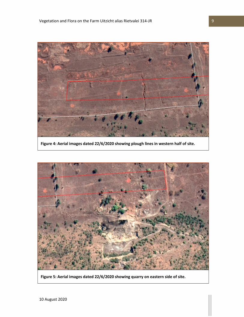
The patterns indicated on the Surveyor-General’s 1:50 000 topo-cadastral map of the area that includes the site (Figure 3) shows that the central to western parts of the site were previously cultivated. However, typical plough-line patterns evident on the aerial image of the site dated 22 June 2020 (Figure 4) clearly indicate that the entire western half was previously cultivated.
It is also evident from desktop information that the site was heavily impacted by quarrying across a large part of the eastern part of the site (see quarry indicated on the Surveyor-General’s 1:50 000 topo-cadastral map of the area in Figure 3). This quarry and associated disturbance is clearly visible on aerial imagery for the site (Figure 5).
Figure 3: Surveyor-generals 1:50 000 topo-cadastral map of the site and surrounding areas.
9 Vegetation and Flora on the Farm Uitzicht alias Rietvalei 314-JR
10 August 2020
Figure 4: Aerial images dated 22/6/2020 showing plough lines in western half of site.
Figure 5: Aerial images dated 22/6/2020 showing quarry on eastern side of site.

10 Vegetation and Flora on the Farm Uitzicht alias Rietvalei 314-JR
10 August 2020
Regional vegetation patterns in relation to the site
According to the most recent vegetation map of the country (Mucina et al., 2005) the study area falls within one regional vegetation type, namely Gold Reef Mountain Bushveld. There are no other vegetation type mapped as being within close proximity to the site. Any remaining vegetation on site therefore falls within Gold Reef Mountain Bushveld.
Gold Reef Mountain Bushveld
Distribution
Gold Reef Mountain bushveld is found in North-West, Gauteng, Free State and Mpumalanga Provinces. It occurs along rocky quartzite ridges of the Magaliesberg and the parallel ridge to the south, from around Boshoek and Koster in the west to near Bronkhorstspruit in the east. The west-east-trending ridge of the Witwatersrand from around Krugersdorp in the west, through Roodepoort and Johannesburg to Bedfordview (Germiston District). Inner ridges (e.g. Dwarsberg and Witkop) of the Vredefort Dome on the Vaal River northwest of Parys and part of the Suikerbosrand and some other hills around Heidelberg. The altitude range is 1 200–1 750 m
Vegetation & Landscape Features
It is found on rocky hills and ridges often west-east trending with more dense woody vegetation often on the south-facing slopes associated with distinct floristic differences (e.g. preponderance of Vachellia caffra on the southern slopes). Tree cover elsewhere is variable. Tree and shrub layers are often continuous. Herbaceous layer is dominated by grasses.
Geology & Soils
This area consists predominantly of quartzites, conglomerates and some shale horizons of the Magaliesberg, Daspoort and Silverton Formations (Vaalian Pretoria Group) and the Hospital Hill, Turffontein and Government Subgroups (Randian Witwatersrand Supergroup). Soils are shallow, gravel lithosols of the Mispah and Glenrosa forms. Land types mainly Ib and Fb.
Climate
Summer rainfall with very dry winters. MAP about 600–750 mm. Frost frequent in winter (especially in the south), but less common on the ridges and hills. Mean monthly maximum and minimum temperatures for Krugersdorp 30.8°C and –1.8°C for January and July, respectively.
Important Taxa
Small Trees: Acacia caffra (d), Combretum molle (d), Protea caffra (d), Celtis africana, Dombeya rotundifolia, Englerophytum magalismontanum, Ochna pretoriensis, Rhus leptodictya, Vangueria infausta, V. parvifolia, Ziziphus mucronata.

11 Vegetation and Flora on the Farm Uitzicht alias Rietvalei 314-JR
10 August 2020
Tall Shrubs: Canthium gilfillanii, Ehretia rigida subsp. rigida, Grewia occidentalis, Gymnosporia buxifolia, Mystroxylon aethiopicum subsp. burkeanum.
Low Shrubs: Athrixia elata, Pearsonia cajanifolia, Rhus magalismontana subsp. magalismontana, R. rigida var. rigida.
Woody Climber: Ancylobotrys capensis.
Graminoids: Loudetia simplex (d), Panicum natalense (d), Schizachyrium sanguineum (d), Trachypogon spicatus (d), Alloteropsis semialata subsp. eckloniana, Bewsia biflora, Digitaria tricholaenoides, Diheteropogon amplectens, Sporobolus pectinatus, Tristachya biseriata, T. leucothrix.
Herbs: Helichrysum nudifolium, H. rugulosum, Pentanisia angustifolia, Senecio ve¬nosus, Xerophyta retinervis.
Geophytic Herbs: Cheilanthes hirta, Hypoxis hemerocallidea, Pellaea calomelanos.
Endemic Taxa
Succulent Shrub: Aloe peglerae.
Succulent Herb: Frithia pulchra

12 Vegetation and Flora on the Farm Uitzicht alias Rietvalei 314-JR
10 August 2020
Vegetation conservation status
National status
The conservation status of Gold Reef Mountain bushveld is Least threatened with 23% conserved of a target of 24% and 15% transformed (Mucina et al., 2006).
Gold Reef Mountain Bushveld is not listed in The National List of Ecosystems that are Threatened and need of protection (GN1002 of 2011), published under the National Environmental Management: Biodiversity Act (Act No. 10, 2004).
There are two other threatened ecosystems in the general area that are associated with the Magaliesberg, namely Magaliesberg Pretoria Mountain Bushveld (listed as Critically Endangered), delineated as the Magaliesberg ridge system and associated koppies in Pretoria North, Pretoria and Silverton, and Witwatersberg Pretoria Mountain Bushveld (listed as Critically Endangered), delineated as the Witwatersberg ridge system and associated koppies, rivers and drainage lines in Pretoria West. Neither of these ecosystems is in proximity to the current site (see Figure 6).
Figure 6: Threatened ecosystems relative to the site (blue dot near centre of map).

13 Vegetation and Flora on the Farm Uitzicht alias Rietvalei 314-JR
10 August 2020
Table 3: Conservation status of vegetation types occurring in the study area, according to Driver et al. 2005 / Mucina et al. 2005 and the National Ecosystem List of the National Environmental Management: Biodiversity Act.
Vegetation Type Conservation status
(Mucina et al. 2005)
Status
(NEMBA)
Gold Reef Mountain Bushveld Least Threatened Not listed

14 Vegetation and Flora on the Farm Uitzicht alias Rietvalei 314-JR
10 August 2020
Provincial C-Plan status
The Gauteng C-Plan version 3.3 classifies the natural vegetation of the province according to conservation value in decreasing value, as follows:
1. Protected
2. Irreplaceable
3. Important
4. Ecological Support Area
According to the Gauteng Conservation Plan, no parts of the site are mapped as within any C-Plan area, although the entire ridge directly to the south is mapped as “Ecological Support Area” (see map in Figure 7). This indicates that the remaining vegetation on site is not considered to be important for the conservation of biodiversity in the Province nor for maintaining ecological patterns in the landscape.
Figure 7: Gauteng C-Plan of the site and surrounding areas.

15 Vegetation and Flora on the Farm Uitzicht alias Rietvalei 314-JR
10 August 2020
Methodology
Requirements for Initial Site Sensitivity Verification Prior to beginning the assessment, the current use of the land and the potential environmental sensitivity of the site as identified by the national web based environmental screening tool must be confirmed by undertaking an Initial Site Sensitivity Verification.
1. The Initial Site Sensitivity Verification must be undertaken by an Environmental Assessment Practitioner or a registered specialist with expertise in the relevant environmental theme being considered.
2. The Initial Site Sensitivity Verification must be undertaken through the use of:
a. a desk top analysis, using satellite imagery; and
b. a preliminary on-site inspection to identify if there are any discrepancies with the current use of land and environmental status quo versus the environmental sensitivity as identified on the national web based environmental screening tool, such as new developments, infrastructure, indigenous/pristine vegetation, etc.
3. The outcome of the Initial Site Sensitivity Verification must be recorded in the form of a report that-
a. confirms or disputes the current use of the land and environmental sensitivity as identified by the national web based environmental screening tool;
b. contains a motivation and evidence (e.g. photographs) of either the verified or different use of the land and environmental sensitivity; and
c. is submitted together with the relevant assessment report prepared in accordance with the requirements of the Environmental Impact Assessment Regulations.
An applicant intending to undertake an activity identified in the Scope of this Protocol, on a site identified as being of “very high sensitivity” for terrestrial biodiversity on the national web based environmental screening tool must submit a Terrestrial Biodiversity Impact Assessment. However, where the information gathered from the Initial Site Sensitivity Verification or the specialist assessment differs from the designation of “very high” terrestrial biodiversity sensitivity from the national web based environmental screening tool and it is found to be of a “low” sensitivity, then a terrestrial biodiversity impact assessment is not required.
Should the above apply, a Terrestrial Biodiversity Compliance Statement is to be provided. An Environmental Assessment Practitioner or a suitably qualified and SACNASP registered specialist, must append to the Terrestrial Biodiversity Compliance Statement a motivation and evidence (e.g. photographs) of the changed Terrestrial Biodiversity sensitivity.

16 Vegetation and Flora on the Farm Uitzicht alias Rietvalei 314-JR
10 August 2020
Site survey
A reconnaissance survey of the entire site was conducted on 7 July 2020. At that time a checklist of species occurring on site was collected and the site was investigated in detail in order to ensure that all parts were covered during the survey. Photographs and other information were collected to determine the current status of the site.
The site was traversed by foot and species listed as they were encountered. Plant names follow Germishuizen et al. (2005) and any taxonomic updates, as found on the SANBI website. The season of the survey in 2016 was not favourable for documenting biodiversity but was adequate for determining the natural status of the site. It is likely that only a proportion of species present on site were identifiable at the time of the survey. A follow-up survey would be required to fully quantify floristic diversity, if this is considered to be necessary.
Red List plant species
A list of Red List flora species which could potentially occur within the study area was compiled from existing data (refer to Appendix 1). Lists of historical occurrences of Threatened and Orange List plant species were obtained from GDARD within the quarter degree squares in which the site is located. Information about the species on this list were updated from literature sources and from information provided by GDARD. The list was evaluated to determine which species were likely to occur in the available habitats in the study area. For all listed plant species that occur in the general geographical area of the site, a rating of the likelihood of it occurring on site is given as follows:
LOW: no suitable habitats occur on site / habitats on site do not match habitat description for species;
MEDIUM: habitats on site match general habitat description for species (e.g. grassland), but detailed microhabitat requirements (e.g. rocky grassland on shallow soils overlying dolomite) are absent on the site or are unknown from the descriptions given in the literature or from the authorities;
HIGH: habitats found on site match very strongly the general and microhabitat description for the species (e.g. rocky grassland on shallow soils overlying dolomite);
DEFINITE: species found on site.
Protected trees
Regulations published for the National Forests Act (Act 84 of 1998) as amended, provide a list of protected tree species for South Africa. The species on this list were assessed in order to

17 Vegetation and Flora on the Farm Uitzicht alias Rietvalei 314-JR
10 August 2020
determine which protected tree species have a geographical distribution that coincides with the study area and habitat requirements that may be met by available habitat in the study area. The distributions of species on this list were obtained from published sources (e.g. van Wyk & van Wyk 1997) and from the SANBI Biodiversity Information System website (http://sibis.sanbi.org/) for quarter degree grids in which species have been previously recorded. Species that have been recorded anywhere in proximity to the site (within 100 km), or where it is considered possible that they could occur there, were listed and were considered as being at risk of occurring there. The site was searched for these species during the field survey and any individuals or concentrations noted.
Sensitivity assessment
The purpose of producing a habitat sensitivity map is to provide information on the location of potentially sensitive features in the study area. This was compiled by taking the following into consideration:
1. The general status of the vegetation of the study area was derived by compiling a landcover data layer for the study area (sensu Fairbanks et al. 2000) using available satellite imagery and aerial photography. From this it can be seen which areas are transformed versus those that are still in a natural status.
2. Various provincial, regional or national level conservation planning studies have been undertaken in the area, e.g. North West Biodiversity Sector Plan 2015. The mapped results from these were taken into consideration in compiling the habitat sensitivity map.
3. Habitats in which various species occur that may be protected or are considered to have high conservation status are considered to be sensitive.
According to GDARD “Requirements for Biodiversity Assessments”, all untransformed grasslands have to be classified as having high sensitivity.

18 Vegetation and Flora on the Farm Uitzicht alias Rietvalei 314-JR
10 August 2020
Results of field survey of site
This section provides a description of vegetation and flora patterns found on site, as determined from the field survey in combination with mapping from aerial imagery. Historical aerial imagery was used to attempt to understand the extensive patterns of disturbance seen on site during the field survey.
Vegetation patterns on site
Vegetation and habitat types on site are significantly determined by the land-use history of the site, with disturbance playing a role in determining species composition. The vegetation on the site is shown in Figures 8 to 11.
Figure 8: View from eastern end of site (note alien trees in background).

19 Vegetation and Flora on the Farm Uitzicht alias Rietvalei 314-JR
10 August 2020
Significant parts of the site consists of previously mined or disturbed areas as well as previously cultivated areas. Based on historical aerial imagery, there is a small patch of vegetation on site that may possibly be in a natural state, but the species composition does not indicate this, which means this small area is probably also disturbed. All the habitat on site is covered with a uniform secondary grassland in which there are dotted indigenous and exotic trees.
Secondary grassland contained a variety of grass species, including Andropogon appendiculatus, Aristida congesta subsp. congesta, Aristida diffusa, Cynodon dactylon, Digitaria erianthe, Eragrostis species, Eragrostis superba, Heteropogon contortus, Melinis repens, Pogonarthria squarrosa, Perotis patens, Brachiaria serrata, Setaria sphacelata and Sporobolus africanus, accompanied by Bulbostylis burchellii, Bidens bipinnata, Ceratotheca triloba, Pygmaeothamnus zeyheri, Senecio species, Pollichia campestris, Schkuhria pinnata, Nidorella hottentotica, Tagetes minuta and Vernonia poskeana. This is a relatively diverse species composition for secondary vegetation, but includes primarly species expected in disturbed or secondary habitats, along with some remnants of nautal habitat. There were a number of woody species on site, including the indigenous species, Searsia lancea, Searsia leptodictya, Lopholaena coriifolia, Vachellia nilotica,
Figure 9: Remnant surface gravel on parts of the site from quarrying activities.

20 Vegetation and Flora on the Farm Uitzicht alias Rietvalei 314-JR
10 August 2020
Ziziphus mucronata, Dichrostachys cinerea, Ozoroa paniculosa, Vangueria infausta and Burkea africana, and the exotic species Acacia podalyriifolia, Eucalyptus camaldulensis, Lantana camara, and Melia azedarach. Note that the woody species all occurred in the eastern half of the site that had not been previously cultivated.
Flora of the site
All plant species found during the survey in remaining natural areas are listed in Appendix 2. Due to the fact that the fieldwork component of this survey was based on a single survey in winter, the species list provided is unlikely to be comprehensive, but provides a good indication of the species composition of the study area. It also provides adequate information for determining the natural status of habitats on site. In the species list (Appendix 2) all exotic species are indicated by an asterisk.
Figure 10: Disturbed areas (excavations and stockpiles) from quarrying.

21 Vegetation and Flora on the Farm Uitzicht alias Rietvalei 314-JR
10 August 2020
A total of 54 species were recorded on the site during the field survey, 3 of which are exotic and an additional 9 of which are declared weeds or invader plants. The proportion of naturalized exotic and invader species is moderate high (22%), despite the high levels of disturbance of habitat on site. Any further analysis of the flora patterns is limited by the winter survey of the site which generates a reduced list of species present on site.
Figure 11: Jeep track through previously cultivated part of site.

22 Vegetation and Flora on the Farm Uitzicht alias Rietvalei 314-JR
10 August 2020
Disturbance on site
The vegetation on site is secondary and previously disturbed. This is due to previous sand mining and disturbance due to quarrying of most of the eastern part of the site (purple area in Figure 12), and previous cultivation on the western half of the site (yellow area in Figure 12). The remaining parts of the site have been continuously disturbed by various activities related to these two main disturbances.
Figure 12: Previously cultivated areas (yellow) and previously mined areas (purple).

23 Vegetation and Flora on the Farm Uitzicht alias Rietvalei 314-JR
10 August 2020
Plant species of concern
Listed species known for the grid in which the site is located are listed in Appendix 1. The list contains 29 species assessed according to IUCN Ver. 3.1 (IUCN, 2001) criteria (Appendix 1).
On the basis of habitat preferences the species could be allocated to habitats within the study area where they are most likely to be found. On the basis of information provided by GDARD, a total of 3 species were considered to have a moderate possibility of occurring on site. The other species listed (Appendix 1) have a low chance of occurring in the study area. All three species are found in grassland and, although secondary, the main habitat structure on site is grassland. The fact that it is secondary means it is unlikely that any of these three species would occur there.
Two species identified in the DEA online screening tool were included in this assessment and were considered to have a low likelihood of occurring on site. The orchid, Brachycorythis conica subsp. transvaalensis is found in short grasslands and/or hillsides, on sandy gravel overlying dolomite, sometimes also on quartzites; occasionally in open woodland, at elevations of 1000-1705 m. At around 1260 m above sea level, the site is within this altitude range, and the substrate is potentially suitable, but the species is unlikely to occur in previously disturbed areas. The herb, Dicliptera magaliesbergensis, is found in forest, savanna, riverine forest and bush, which does not occur on site.
None of the other species listed in Appendix 1 were found on site and, on the basis of the field survey and habitat requirements, there is a possibility that they could occur there.

24 Vegetation and Flora on the Farm Uitzicht alias Rietvalei 314-JR
10 August 2020
Sensitivity assessment
There are no parts of the site that are considered to be sensitive. None of the vegetation on site is considered to in a natural state (all secondary). No parts of the site are within a listed ecosystem or within a C-Plan designated category.

25 Vegetation and Flora on the Farm Uitzicht alias Rietvalei 314-JR
10 August 2020
Discussion
The requirements of this study were to undertake an Initial Site Sensitivity Verification with respect to Terrestrial Biodiversity, as well as for Plants. The web-based screening tool identified the site as being of Very High sensitivity with respect to Terrestrial Biodiversity and Medium sensitivity for Plants. The Initial Site Sensitivity Verification is based on a desktop assessment and a field site verification visit. The results presented here are based on a combination of these two sources.
There appears to be a discrepancy between the sensitivity from the online screening tool and mapped regional Plans. The Very High sensitivity for Terrestrial Biodiversity appears to be a mapping error whereby a C-Plan designated polygon for an “Important” area was not “closed”. The result is that the entire area surrounding this was included within this C-Plan area, whereas the Gauteng C-Plan clearly shows that the site is NOT within any such area (see Figure 7). The site is also not within any threatened ecosystem (see Figure 6) and was found to have only secondary vegetation in previously disturbed areas (based on field site visit as well as historical aerial imagery, Figures 4 and 5, and information from the Surveyor-General’s 1:50 000 topocadastral map of the site, Figure 3). The historical disturbances on site due to previous cultivation on site as well as to quarrying and sand mining activities. The combination of these various historical activities has entirely modified the original natural vegetation so that it is currently composed of secondary grassland with scattered indigenous and exotic trees.
The site is within one regional vegetation type, a grassland vegetation type called Gold Reef Mountain Bushveld, classified as Least Concern, and not listed in the National List of Ecosystems that are Threatened and need of protection (GN1002 of 2011), published under the National Environmental Management: Biodiversity Act (Act No. 10, 2004).
According to the Gauteng C-Plan (version 3.3), none of the site is within a designated area, although adjacent areas to the south are within areas mapped as “Ecological Support Area”.
There are three listed plant species that have habitat requirements that are partially met by those found on site, but none of these species were found on site. Based on the field survey, it is considered unlikely that any of these species could occur there.
Transformed areas on site are not considered to be particularly sensitive or valuable from a botanical perspective. All other areas on site are considered to have LOW sensitivity.

26 Vegetation and Flora on the Farm Uitzicht alias Rietvalei 314-JR
10 August 2020
Conclusion
The following conclusions can be made with regards to the proposed development of the site:
• The entire site is considered to have secondary grassland in previously cultivated and/or mined areas. These areas are considered to have LOW sensitivity. This is in contrast to the VERY HIGH sensitivity given in the online screening tool assessment for the site. The verification provided here, supported by a desktop assessment and a field verification, confirms that the site has LOW sensitivity.

27 Vegetation and Flora on the Farm Uitzicht alias Rietvalei 314-JR
10 August 2020
References BROMILOW, C. 2010. Problem plants and alien weeds of South Africa. Briza, Pretoria.
CAMPBELL, PETA. date unknown. Rehabilitation recommendations after alien plant control and Wattle Control. ARC-PPRI publication.
DENT, M.C., LYNCH, S.D. & SCHULZE, R.E. 1989. Mapping mean annual and other rainfall statistics in southern Africa. Department of Agricultural Engineering, University of Natal. ACRU Report No. 27. Massachusetts: Clark University.
DRIVER, A., MAZE, K., ROUGET, M., LOMBARD, A.T., NEL, J., TURPIE, J.K., COWLING, R.M., DESMET, P., GOODMAN, P., HARRIS, J., JONAS, Z., REYERS, B., SINK, K and STRAUSS, T. 2005. National Spatial Biodiversity Assessment 2004: priorities for biodiversity conservation in South Africa. Strelitzia 17. South African National Biodiversity Institute, Pretoria.
FAIRBANKS, D.H.K., THOMPSON, M.W., VINK, D.E., NEWBY, T.S., VAN DEN BERG, H.M & EVERARD, D.A. 2000. The South African Land-Cover Characteristics Database: a synopsis of the landscape. S.Afr.J.Science 96: 69-82.
GERMISHUIZEN, G., MEYER, N.L., STEENKAMP, Y and KEITH, M. (eds.) (2006). A checklist of South African plants. Southern African Botanical Diversity Network Report No. 41, SABONET, Pretoria.
HENDERSON, L. 2001. Alien weeds and invasive plants. Agricultural Research Council.
HOARE, D.B., PFAB, M. and MILLS, L. in prep. A floristic classification of the grassland vegetation of Gauteng.
IUCN (2000). IUCN Red List Categories. Prepared by the IUCN Species Survival Commission. Gland, Switzerland.
IUCN (2001). IUCN Red Data List categories and criteria: Version 3.1. IUCN Species Survival Commission: Gland, Switzerland.
JOHNSON, S., BYTEBIER, B. and STARKER, H. 2015. Orchids of South Africa, A Field Guide. Struik Nature, Cape Town.
MACVICAR, C. N., SCOTNEY, D. M. SKINNER, T. E. NIEHAUS, H. S. & LOUBSER, J. H., 1974. A classification of land (climate, terrain form, soil) primarily for rainfed agriculture. S. Afr. J. Agric. Extension, 3(3): 1-4.
MUCINA, L, BREDENKAMP, G.J., HOARE, D.B & MCDONALD, D.J. 2000. A National Vegetation Database for South Africa South African Journal of Science 96: 1–2.

28 Vegetation and Flora on the Farm Uitzicht alias Rietvalei 314-JR
10 August 2020
MUCINA, L. AND RUTHERFORD, M.C. (editors) 2006. Vegetation map of South Africa, Lesotho and Swaziland: an illustrated guide. Strelitzia 19, South African National Biodiversity Institute, Pretoria.
MUCINA, L., RUTHERFORD, M.C. AND POWRIE, I.W. (editors) 2005. Vegetation map of South Africa, Lesotho and Swaziland, 1:1 000 000 SCALE SHEET MAPS South African National Biodiversity Institute, Pretoria.
MUCINA, L., RUTHERFORD, M.C., HOARE, D.B. & POWRIE, L.W. 2003. VegMap: The new vegetation map of South Africa, Lesotho and Swaziland. In: Pedrotti, F. (ed.) Abstracts: Water Resources and Vegetation, 46th Symposium of the International Association for Vegetation Science, June 8 to 14 – Napoli, Italy.
MUELLER-DOMBOIS, D. AND ELLENBERG, H. 1974, Aims and Methods of Vegetation Ecology, John Wiley and Sons, New York.
PFAB, M.F. & VICTOR, J.E. (2002) Threatened plants of Gauteng, South Africa. South African Journal of Botany. 68: 370–375.
RUTHERFORD, M.C. & WESTFALL, R.H. (1994). Biomes of southern Africa: an objective categorization. Memoirs of the Botanical Survey of South Africa No. 63.
RUTHERFORD, M.C., MUCINA, L., LÖTTER, M.C., BREDENKAMP, G.J., SMIT, J.H.L., SCOTT-SHAW, R., HOARE, D.B. GOODMAN, P.S., BEZUIDENHOUT, H., SCOTT, L. and ELLIS, F. 2006. Savanna Biome. In: Mucina, L. & Rutherford, M.C. (eds.) Vegetation map of South Africa, Lesotho and Swaziland: an illustrated guide. Strelitzia 19. South African National Biodiversity Institute, Pretoria.
SACS (South African Committee for Stratigraphy) (1980). Stratigraphy of South Africa Part 1. (comp. Kent, L.E.) Lithostratigraphy of South Africa, South West Africa/Namibia and the Republics of Bophuthatswana, Transkei and Venda. Handbook of the Geological Survey of South Africa 8. Government Printer, Pretoria.

29 Vegetation and Flora on the Farm Uitzicht alias Rietvalei 314-JR
10 August 2020
Appendix 1: Red / Orange List plant species recorded within the quarter degree within which the study area is situated, namely 2528CA.
Taxon Latest (IUCN
version 3.1)
Conservation
Status**
Habitat Flowering
Time
Probability of
occurrence*
Adromischus
umbraticola subsp.
umbraticola
Near Threatened
(NT)
Rock crevices on rocky ridges, usually
south-facing, or in shallow gravel on top of
rocks, but often in shade of other
vegetation.
September-
January
LOW, habitat
does not match
Alepidia attenuata Near Threatened
(NT)
Wetlands in grassland. January-
March
LOW, habitat
does not match
Aloe peglerae Endangered (EN) Grassland, in shallow, gravelly quartzitic
soils on rocky north-facing slopes or
summits of ridges.
July-August LOW, no
suitable habitat
on site
Boophone disticha Declining Dry grassland and rocky areas. October-
January
LOW, habitat
does not match
Bowiea volubilis subsp.
volubilis
Near Threatened
(NT)
Shady places, steep rocky slopes and in
open woodland, under large boulders in
bush or low forest.
September-
April
LOW, no
suitable habitat
on site
Brachycorythis conica
subsp. transvaalensis
Endangered (EN) Short grasslands, hillsides, on sandy gravel
overlying dolomite, sometimes also on
quartzites; occasionally open woodland,
1000-1705 m.
January-
March
LOW, no
suitable natural
habitat on site
Callilepis leptophylla Declining Grassland or open woodland, often on
rocky outcrops or rocky hillslopes.
August–
January & May
LOW, no
suitable habitat
on site
Cheilanthes deltoidea
subsp. silicola
Vulnerable (VU) Southwest-facing soil pockets and rock
crevices in chert rock.
November-
June
LOW, geology &
habitat does not
match

30 Vegetation and Flora on the Farm Uitzicht alias Rietvalei 314-JR
10 August 2020
Cineraria
austrotransvaalensis
Near Threatened
(NT)
Amongst rocks on steep slopes of hills and
ridges, as well as at the edge of thick bush
or under trees; on all aspects and on a
range of rock types: quartzite, dolomite
and shale; 1400 – 1700 m.
March-June LOW, habitat
does not match
Ceropegia deciduas
subsp. pretoriensis
Vulnerable (VU) Direct sunshine or shaded situations,
rocky outcrops of the quartzitic
Magaliesberg mountain series, in pockets
of soil among rocks, in shade of shrubs and
low trees, can be seen twining around
grass spikes. 2528CC
November-
April
LOW, geology /
habitat does not
match
Cleome conrathii Near Threatened
(NT)
Stony quartzite slopes, usually in red
sandy soil, grassland or open to closed
deciduous woodland, all aspects.
March-May,
December-
January
LOW, habitat
does not match
Crinum macowanii Declining Grassland, along rivers, in gravelly soil or
on sandy flats.
October-
January
LOW, no
suitable habitat
on site
Delosperma
leendertziae
Near threatened
(NT)
Rocky ridges on rather steep south-facing
slopes of quartzite in mountain grassveld.
October-April LOW, habitat
does not match
Dicliptera
magaliesbergensis
Vulnerable (VU) Forest, savanna, riverine forest and bush. February-April LOW, habitat
does not match
Drimia altissima Declining Hot, dry bushveld and thicket. September-
February
LOW, habitat
does not match
Drimia sanguinea Near threatened
(NT)
Open veld and scrubby woodland in a
variety of soil types.
August-
December
LOW, habitat
does not match
Eucomis autumnalis
subsp. clavata
Declining Open grassland, marshes. November-
April
LOW, habitat
does not match
Gunnera perpensa Declining Western Cape to Ethiopia. Damp marshy
area and vleis from coast to 2400 m.
October-March
LOW, habitat does not match
Habenaria barbetoni Near threatened
(NT)
In grassland on rocky hillsides. February-
March
LOW, habitat
does not match
Habenaria
kraenzliniana
Near threatened
(NT)
Terrestrial in stony, grassy hillsides,
recorded from 1000 to 1400 m.
February-April LOW, habitat
does not match

31 Vegetation and Flora on the Farm Uitzicht alias Rietvalei 314-JR
10 August 2020
Habenaria mossii Endangered (EN) Open grassland on dolomite or in black
sandy soil.
March-April LOW, habitat
does not match
Holothrix randii Near threatened
(NT)
Grassy slopes and rock ledges, usually
southern aspects.
September-
October
LOW, habitat
does not match
Hypoxis hemerocallidea Declining Grassland and mixed woodland. January-
March
MEDIUM,
habitat partially
matches
Ilex mitis var. mitis Declining Riverbanks, streambeds, evergreen
forests.
October–
December
LOW, habitat
does not match
Lithops lesliei subsp.
lesliei
Near threatened
(NT)
Primary habitat appears to be the arid
grasslands in the interior of South Africa
where it usually occurs in rocky places,
growing under the protection of
surrounding forbs and grasses.
March-June LOW, habitat
does not match
Melolobium
subspicatum
Vulnerable (VU) Grassland. September-
May
MEDIUM,
habitat partially
matches
Pearsonia bracteata Near threatened
(NT)
Plants in Gauteng and North West occur in
gently sloping Highveld grassland, while
those in the Wolkberg were collected
from steep wooded slopes and cliffs in
river valleys.
December-
April
MEDIUM,
habitat partially
matches
Prunus africana Vulnerable (VU) Evergreen forests near the coast, inland
mistbelt forests and afromontane forests
up to 2100 m.
December-June
LOW, habitat does not match
Xerophyta adendorfii Vulnerable (VU) Dolomite and quartzite ridges and
outcrops.
September-
March
LOW, habitat
does not match
* Conservation Status Category assessment according to IUCN Ver. 3.1 (IUCN, 2001), as evaluated by the Threatened Species Programme of the South African National Biodiversity Institute in Pretoria. *IUCN (3.1) Categories: VU = Vulnerable, EN = Endangered, CR = Critically Endangered, NT = Near Threatened.

32 Vegetation and Flora on the Farm Uitzicht alias Rietvalei 314-JR
10 August 2020
Appendix 2: Checklist of plant species found on site
Species Category Acacia podalyriifolia* Category 1b Andropogon appendiculatus Aristida congesta subsp. congesta Aristida diffusa Aristida species Bidens bipinnata* Brachiaria serrata Bulbostylis burchellii Burkea africana Cenchrus setaceus* Category 1b Ceratotheca triloba Cereus jamacaru* Category 1b Combretum zeyheri Croton gratissimus Cryptolepis oblongifolia Cymbopogon pospischillii Cynodon dactylon Dichrostachys cinereus Digitaria erianthe Dombeya rotundifolia Englerophytum magalismontanum Eragrostis rigidior Eragrostis superba Eucalyptus camaldulensis* Category 1b within riparian areas, Protected Areas,
Listed Ecosystems, Fynbos, Grassland, Savanna, Albany Thicket, Forest, Indian Ocean Coastal Belt, with some exclusions (see Act)
Heteropogon contortus Jacaranda mimosifolia* Category 1b in GP, KZN, LIM, MP, NW, not listed for
urban areas, with other exclusions (see Act) Lantana camara* Category 1b Lopholaena coriifolia Melia azeradach* Category 1b, 3 in urban areas Melinis repens Nidorella hottentotta Ozoroa paniculosa subsp. salicina Parinari capensis Pelargonium species Pennisetum sphacelatum Perotis patens Pollichia campestris Pogonarthria squarrosa

33 Vegetation and Flora on the Farm Uitzicht alias Rietvalei 314-JR
10 August 2020
Polydora poskeana Category 2 Pygmaeothamnus zeyheri Schkuhria pinnata* Searsia lancea Searsia leptodictya Senecio species Setaria sphacelata Solanum mauritianum* Category 1b Sporobolus africanus Tagetes minuta* Themeda triandra Triumfetta species Vachellia nilotica Vachellia robusta Vangueria infausta Ziziphus mucronata