vanuatu country report 2018, nadi fiji · 2019-04-09 · vanuatu country report 2018, nadi fiji...
TRANSCRIPT

VANUATU COUNTRY REPORT
2018, Nadi FIJI
Chair and distinguish colleagues,
Allow me on the outset to firstly thank the organisers of the 15th South West Pacific
Hydrographic Commission to make it possible for us to continue to meet despite the last minute
changes to the venue. I also like to thank Fiji for the warm hospitality.
Vanuatu cannot afford to be relaxed anymore when half a million tourist are expected to come
into our shores by cruise liner in the next decades. Not only that, we have also spend over 10
million US dollars to upgrade our wharfs both in Port Vila and Santo to cater for the cruise liners
and container ships.
For that reason we believe it is timely that our full membership to the IHO and the South West
Pacific Hydrographic Commission are justified and we are committed to meeting our
fundamental obligations under the SOLAS conventions hence ensuring safety of life at sea.
To move forward we have consulted and agreed for cabinet to approved the following by end of
March 2018
1.
Legislations;
Formalised the National Hydrographic Committee through legislation and with the specific
Terms of Reference.
Annex1 TOR of the National Hydrographic Committee;
2.
Survey Plan
Cabinet has already approval the survey plan of 10 priorities areas and further approval will be
sought for another additional 22 areas which should be considered for survey once the priority
areas are complete.
Annex 2 Survey Plan
3.
Standards
A review of standards was undertaken and a working knowledge of the standards. A copy of all
relevant standards has been provided to all stakeholders for information purposes.
4.
Formation of a Hydrographic Survey Unit
A new Hydrographic Survey Unit will be the responsibilities to Lands and Surveys as it is
established and builds to full capability with a direct reporting line to the OMR and Committee.
Annex 3 Role of the National Hydrographic survey
5.
Maritime Safety Information
At present, there is a National Coordinator but a Terms of Reference has yet to be approved by
cabinet:
Annex 4 TOR of the National Coordinator

Annex1 TOR of the National Hydrographic Committee;
To recommend national policy in the field of hydrographic survey services of Vanuatu via
the OMR.
To take appropriate measure for the improvement of hydrographic survey services of
Vanuatu.
To co-ordinate the activities of the organisations engaged in hydrographic survey works
of the waters of Vanuatu to avoid duplication.
To extend technical advice and guideline to the member organisations to ensure the
quality control of the collected data and the production of chart as per IHO Standard.
To ensure hydrographic data exchange among the member organisations to facilitate
research activities in the field of hydrography.
To co-ordinate training facilities at home and abroad in the field of hydrographic survey
for the officials of the member organisations.
To allocate, if necessary, additional survey and data collection works to the hydrographic
organisations in Vanuatu, besides their individual programme to meet the national and
international requirements, such as determination of maritime boundary and exploitation
of under water resources etc.
To recommend scale indexes of chart as per national requirements and advice the
executing organisation to prepare their chart accordingly.
To act as facilitators among the various oceanographic, hydrographic and
meteorological data banks for future use, research and supply those to the national and
international users.

Annex 2
Vanuatu
Prioritised Survey Programme 2018-2023
Priority Area Requirement
1 Port Paterson – Vanau Lava Area 100km2 Est 90.2M Vatu
1. Unsurveyed 2. Sola to become main Port
of Entry following agreement between Vanuatu and Solomon Islands
1 Larup Bay – Ureparapare Area 24km2 Est 21.65M Vatu
1. Unsurveyed
2 Port Sandwich – Malekula Area 81km2 Est 73.1M Vatu
1. Unsurveyed 2. High Risk 3 vessels have
grounded 3. Potential for export of
Copra 4. Port of Entry to for
domestic and international shipping

2 South West Bay – Malekula Area 82km2 Est 73.3M Vatu
1. Unsurveyed
3 Bougainville Strait Area 308km2
Est 277.8M Vatu
1. Unsurveyed 2. Transit Route for Shipping
4 Lolowai Bay – Ambae Area 19km2 Est 17.2M Vatu
1. Unsurveyed 2. ADB to fund new Jetty 3. Provide Safe Emergency
Route for evacuation
4 Melsisi - Pentecost Area 16km2 Est 14.4M Vatu
1 Unsurveyed 2 Anchorage 3 Provide Safe Emergency
Route for evacuation
5 Bwatnpne Bay – Pentecost Area 26km2
4 Unsurveyed 5 Port of Entry 6 New Jetty being
constructed 7 Export potential for crops
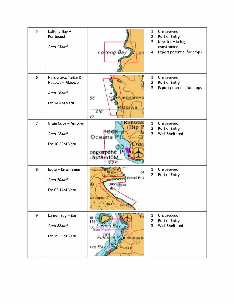
5 Loltong Bay – Pentecost Area 14km2
1 Unsurveyed 2 Port of Entry 3 New Jetty being
constructed 4 Export potential for crops
6 Narovrovo, Talise & Nasawa – Maewo Area 16km2 Est 14.4M Vatu
1 Unsurveyed 2 Port of Entry 3 Export potential for crops
7 Graig Cove – Ambryn Area 12km2
Est 10.82M Vatu
1 Unsurveyed 2 Port of Entry 3 Well Sheltered
8 Ipota – Erromango Area 70km2
Est 63.14M Vatu
1 Unsurveyed 2 Port of Entry
9 Lamen Bay – Epi Area 22km2
Est 19.85M Vatu
1 Unsurveyed 2 Port of Entry 3 Well Sheltered

10 Aver – Gaua Area 34km2
Est 30.67M Vatu
1. Unsurveyed 2. Provide Safe Emergency
Route for evacuation 3. Lake Letas – potential
tourism site
11 Litchlitch – Malekula Area 132km2
Est 119.1M Vatu
1 Unsurveyed 2 Port of Entry 3 Export potential for crops 4 Marine Reserve for
Mangroves
12 Big Bay – Santo Area 121km2
Est 109.1M Vatu
1 Unsurveyed 2 Export potential for crops 3 Marine Reserve
13 Maskelyne Islands – Malekula Area 147km2
Est 132.6M Vatu
1 Unsurveyed 2 Used by Yachts 3 Marine Reserve
14 Ngerein Bay - Loh Area 4km2
Est 3.61M Vatu
1. Unsurveyed 2. Port of Entry

15 Tolamp Reef - Malekula Area 28km2
Est 25.30M Vatu
1. Unsurveyed 2. Cruise Vessel
Access/Anchorage
16 Palikulo Bay – Santo Area 31km2
Est 27.96M Vatu
1 Not Recently surveyed 2 Cyclone Anchorage
17 Lathi Island Passage - Lathi Area 20km2
Est 18.1M Vatu
1 Not recently surveyed 2 Used by local and small
vessels for transit
18 Remarkable Point Shoal - Santo Area 23km2
Est 20.75M Vatu
1 Not recently surveyed 2 Shoal in deep water close
to ship transit routes
19 Pamal - Ambrym Area 7km2
Est 6.31M Vatu
1 Unsurveyed 2 Port of Entry

20 D’Estrees Bank - Ambrym Area 34km2
Est 30.67M Vatu
1 Unsurveyed 2 Used by Yachts 3 Marine Reserve
21 Mukokona - Tongoa Area 13km2
Est 3.61M Vatu
1 Unsurveyed 2 Port of Entry
22 Cook Reef - Emae Area 27km2
Est 24.35M Vatu
1 Not Fully surveyed close to a shipping route
23 Sulua Bay - Emae Area 15km2
Est 13.53M Vatu
3 Unsurveyed 4 Port of Entry
24 Port Havannah - Efate Area 58km2
Est 52.3M Vatu
1 Not recently surveyed 2 Used by Yachts

25 Lelepa Passage - Efate Area 3km2
Est 2.71M Vatu
1 Unsurveyed 2 Used by Yachts
26 Mele Bay East - Efate Area 9km2
Est 8.20M Vatu
1 Not recently surveyed 2 Potential deep water
anchorage
27 Mele Bay North - Efate Area 11km2
Est 9.92M Vatu
1 Not recently surveyed 2 Potential deep water
anchorage
28 Polennia Bay - Erromango Area 81km2
Est 73.1M Vatu
1 Unsurveyed 2 Port of Entry
29 Dillons Bay - Erromango Area 55km2
Est 49.61M Vatu
1 Not fully surveyed 2 Port of Entry

30 Port Patrick - Anatom Area 53km2
Est 47.81M Vatu
1 Unsurveyed 2 Evacuation Route
32 Leaslav Bay – Santa Maria (Gaua) Area 34km2
Est 30.67M Vatu
1 Unsurveyed 2 Evacuation Route
33 Masevono Anchorage – Santa Maria (Gaua) Area 19km2
Est 17.2M Vatu
1 Unsurveyed 2 Evacuation Route
34 Metania Bay – Hiu Area 6km2
Est 5.41M Vatu
1 Unsurveyed 2 Port of Entry
35 Aniwa Island Area 4km2
Est 3.61M Vatu
1 Unsurveyed 2 Port of Entry

Annex 3 Role of the National Hydrographic survey
A National Hydrographic Survey Unit can be created instantly through existing legislation following
recommendations of the National Hydrographic Committee, however it will not immediately be
effective due to the requirement to develop trained personnel, adequate equipment and national
policies and an interim policy for the conduct of hydrographic surveys should be developed to allow the
development of capability in tandem with the formation of the unit.
The activities of a Hydrographic Unit will be supervised or monitored by an appropriate governmental
authority who are designated responsibility for the proper provision of hydrographic services and to
which any national Hydrographic Survey Unit will report.
The role of the Hydrographic Survey Unit is to collect, through systematic surveys at sea and along the
coast, geo-referenced data related to:
• depths of the seas in the area of national interest (including all potential
• hazards to navigation - considering present and future ships' drafts - and
• other marine activities)
• coastal features, including man-made infrastructures for maritime navigation,
• aids to navigation and port configuration
• the nature of the sea floor
• tides, currents, physical properties of the water column
The Hydrographic Survey Unit should process the information collected in order to create organised
databases capable of supporting the production of nautical charts, thematic maps and other types of
documentation for the following most common uses:
• maritime navigation (and traffic control)
• naval operations
• coastal management
• civil defence
• marine environment preservation

• exploitation of marine resources and laying of submarine cables/pipelines
• definition of maritime boundaries (Law of the Sea implementation)
• scientific studies related to the sea and near-shore zone
Additionally they should update the database through re-survey when and where needed, gathering
supplementary information from other maritime authorities, ensuring the production, distribution of
information for the updating of nautical charts and relevant maps, ensuring the timely dissemination of
data relating to Maritime Safety Information.
A Hydrographic Unit charged with undertaking hydrographic surveys in Vanuatu should consist of
between 3 and 4 personnel. Typically, this would consist of:
Role Qualification Responsibilities
Surveyor in Charge Cat A Surveyor In charge of planning, acquisition, reporting and quality control
Surveyors 2 x Cat B Surveyor Undertakes data acquisition and data processing
Survey Technician Trained locally Supports Cat A/B Surveyors in survey tasks
The following model (Figure 4) is a suggested 5 year programme that would allow the development of a
Hydrographic Survey Unit capable of undertaking national survey obligations:
Figure 4: Proposed Model for development of Hydrographic Survey Unit
The model above assumes that sufficient funding is made available to employ additional personnel,
undertake training and procure equipment. Years 1 to 3 have no equipment and during this phase it is
assumed that surveys will be contractor led and that in specifying surveys that provision is made for
Vanuatu’s own survey team are included in survey operations to gain experience.

As an alternative, in order to build experience would be to use bilateral relationships to explore the
provision of training billets on survey operations (this may be world-wide) in order to provide the
necessary opportunities for professional development.
ANNEX 4 TOR of National Corrdinator
Endeavour to be informed of all events that could significantly affect the safety of navigation
within his region or national area of responsibility (AOR)
Assess all information immediately upon receipt in the light of expert knowledge for relevance
to safety of navigation in their area of national responsibility.
Select information for broadcast in accordance with the guidance given in Assembly Resolution
A.706(17)
Draft coastal warnings in accordance with the Joint IMO/IHO/WMO Manual on Maritime Safety
Information
Direct and control the broadcast of coastal warnings in accordance with SOLAS
Forward coastal warnings and relevant associated information which may require wider
promulgation directly to their NAVAREA Coordinator and/or adjacent National Coordinators as
appropriate, using the quickest possible means.
Broadcast in-force bulletins not less than once per week at a regularly scheduled time
Promulgate the cancellation of coastal warnings which are no longer valid
Act as the central point of contact on matters relating to navigational warnings within their area
of National responsibility
Promote the use of established international standards and practices in the promulgation of
navigational warnings within their area of national responsibility
Monitor the broadcasts which they originate to ensure that the messages have been correctly
broadcast
Maintain records of source data relating to coastal warnings in accordance with the requirement
of the National Administration of the National coordinator
The current co-ordinator is aware of his responsibilities and has established links with the NAVAREA Co-
ordinator along with local contacts who report navigationally significant information to him for analysis
and dissemination.
The infrastructure required to provide a full MSI service have yet to be fully funded and it is not known
when a full MSI capability will be achieved.
