valley county pathways master plan€¦ · prehensive update of the valley county pathways master...
TRANSCRIPT

1
Valley County PathwaysMaster Plan
March 2017
valleycountypathways.org

2
Table of Contents Executive Summary .......................................................................3 Valley County Pathways Master Plan ..........................................12Purpose and Need .........................................................................15Public Outreach and Feedback .......................................................23Identification of Pathway Corridors ..............................................25Goals ..............................................................................................28Recommended Implementation Schedule .....................................29Funding Opportunities for Pathways ............................................30Design Standards ...........................................................................34 Attachment A - Valley County Pathways Master Plan Map Attachment B - McCall Area Pathways Master Plan Attachment C - Greater Donnelly Area Pathways Plan Attachment D - City of Cascade Bicycle and Pedestrian Plan Attachment E - Idaho Bicycle and Pedestrian Plan
Questions regarding this plan should be directed to Steve Stuebner, vice president, Valley County Pathways, 208-484-0295 or [email protected].
www.valleycountypathways.org
3
Executive SummaryMore than 11 years after Valley County Pathways completed the first concept master plan for a system of valley-wide pathways, much has changed. In the mid-2000s, when Tamarack Resort was fully permitted and moving full steam ahead with ambitious development plans, there was a real sense of urgency to reserve pathway corri-dors in the valley -- at least on a conceptual level -- to link the communities of McCall, Lake Fork, Donnelly and Cascade. “We must act now to reserve key pathway corridors before they are bulldozed or paved over,” the 2005 Master Plan stated. “Development around the resort area and in Valley County in general has been sprouting at a frenetic pace. The building boom is happening from McCall to Cascade, and the formerly sleepy town of Don-nelly is in the epicenter, with numerous projects now under construction and more on the way.”
Operating under that sense of urgency, the Valley County Pathways Committee wrote the original concept mas-ter plan in 2005, presented it to the Valley County Planning & Zoning Commission and Valley County Commis-sioners for approval. With strong public support, and unanimous support by the elected officials, the plan was approved.
Since that time, the plan has provided a vital and important vision for the future. Valley County Planning & Zon-ing Commission has used the plan for guidance as new development proposals have occurred. New pathways have been built in McCall, Donnelly and Cascade. All of those communities have created new pathway plans in the last several years. Valley County Pathways has extended the Crown Point Trail via a donation of private land, and pieced together easements and property donations to create the North Valley Trail, south of McCall. The bookends of connecting the old Union Pacific Railroad right of way between McCall and Cascade have been secured, but much work remains to obtain public right of way in that corridor between Lake Fork and Pine Lakes Ranch.
Meanwhile, the urgency of development has changed. In 2008, the Great Recession began to unfold, and the majority owners of Tamarack Resort filed for Chapter 11 bankruptcy protection as the value of real estate in the United States took a deep plunge. The recession brought nearly all development in Valley County to a halt. That gave city and county planning staff officials time to take a deep breath and brace for the next economic recovery. The economy picked up again in 2012, and it has been gaining steam ever since.
With the conclusion of the Great Recession, many industries have fully recovered throughout the West Central Mountains and some are even expanding. New industries, like craft breweries, light manufacturers and artisans have sprouted up in the region, resulting in an expanded focus on recreation and live-work community-based

4
infrastructure. With the addition of new housing in Donnelly and McCall, and more and more people from the knowledge economy relocating to the area, providing the pathway systems for connected communities has been widely considered the most important missing link to help grow local economies. Most recently, community involvement in the national America’s Best Communities (ABC) competition has inspired new-found cooperation among Valley and Adams counties for everyone to work together on a detailed 21-point economic revitalization strategy. The region is now branded as the “West Central Mountains.” A com-prehensive update of the Valley County Pathways master plan was singled out as one of the most simportant initiatives in the economic revitalization strategy. To that end, the ABC initiative has been a catalyst in updating the Valley County Master Plan, and it’s timely to do so.
Today, it’s fair to say that the public pri-orities among elected officials, economic development officials and residents of the two-county area have tilted more in favor of pedestrian pathways, water trails and Nordic trails than ever before. This is a positive change that will benefit the two-county area in terms of economic development, travel and tourism, and creating more pathway amenities for lo-cal residents.
In this master plan update, we are shar-ing and incorporating new pathway plans developed by the cities of McCall, Donnelly and Cascade, updating the goals and priorities for Valley County Pathways, and incorporating the Payette River Basin Water Trails plan. The Water Trails plan, which is an online informa-tion resource (http://valleycountyedc.org/water-trails), provides detailed information and maps for 10 paddling trips in the North Fork Payette River
Basin. These water trails trips are shared on our master plan map. Connectivity is more important now than ever before.
The new Master Plan will work to integrate pathways into new and existing developments, and look for connec-tions to the other local and regional plans at play. Connecting our communities has been a key goal from the beginning. The new Master Plan also provides an important connection from Valley County to Adams County to build a “bridge” across county lines and tie together pathways in both counties. As a new feature, the plan identi-fies key national forest trailheads and connections to water trails adjacent to the valley trails.
In addition, under the mantra of “thinking big” we bring up the possibility of linking together the Weiser River Trail, the North Valley Trail, Crown Point Trail and other potential rail-trail corridors that could be used in the future to make a giant loop from New Meadows and McCall to Cascade, Smith’s Ferry, Banks, Horseshoe Bend, Emmett, Payette and Weiser, and back to New Meadows via the Weiser River Trail. We’re calling that route the “Big Loop” for now. Until the freight and scenic railroad line is phased out between Cascade and Payette, we can work on fulfilling pathway connections in Valley County and Adams County, while tracking what happens to the
Eleanor Putman talks about why she chose to donate 1/4-mile of the railroad right of way to Valley County Pathways in 2005, extending the Crown Point Trail to the Vista Point area.
5
railroad corridor down the road, or we might say, “down the rails.” When and if that railroad section is phased out and abandoned, pathway advocates should be prepared to seize the day and ensure that we can turn the rail-road corridor into a public pathway.
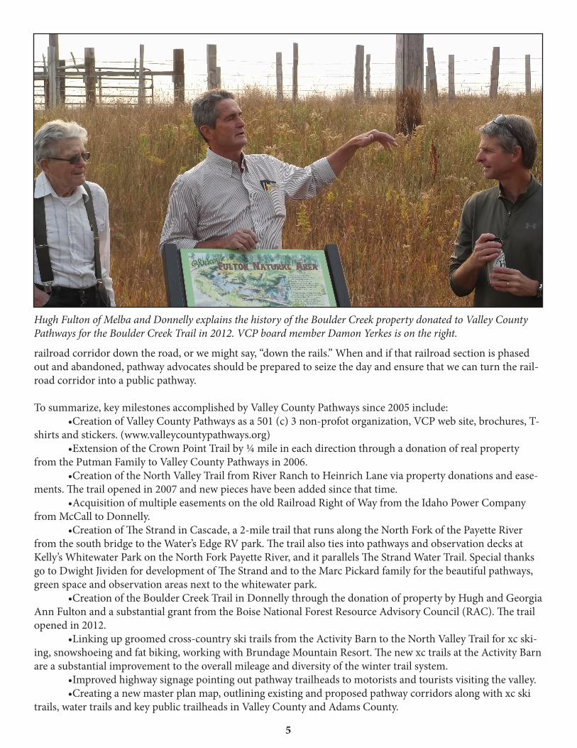
To summarize, key milestones accomplished by Valley County Pathways since 2005 include: •CreationofValleyCountyPathwaysasa501(c)3non-profotorganization,VCPwebsite,brochures,T-shirts and stickers. (www.valleycountypathways.org) •ExtensionoftheCrownPointTrailby¼mileineachdirectionthroughadonationofrealpropertyfrom the Putman Family to Valley County Pathways in 2006. •CreationoftheNorthValleyTrailfromRiverRanchtoHeinrichLaneviapropertydonationsandease-ments. The trail opened in 2007 and new pieces have been added since that time. •AcquisitionofmultipleeasementsontheoldRailroadRightofWayfromtheIdahoPowerCompanyfrom McCall to Donnelly. •CreationofTheStrandinCascade,a2-miletrailthatrunsalongtheNorthForkofthePayetteRiverfrom the south bridge to the Water’s Edge RV park. The trail also ties into pathways and observation decks at Kelly’s Whitewater Park on the North Fork Payette River, and it parallels The Strand Water Trail. Special thanks go to Dwight Jividen for development of The Strand and to the Marc Pickard family for the beautiful pathways, green space and observation areas next to the whitewater park. •CreationoftheBoulderCreekTrailinDonnellythroughthedonationofpropertybyHughandGeorgiaAnn Fulton and a substantial grant from the Boise National Forest Resource Advisory Council (RAC). The trail opened in 2012. •Linkingupgroomedcross-countryskitrailsfromtheActivityBarntotheNorthValleyTrailforxcski-ing, snowshoeing and fat biking, working with Brundage Mountain Resort. The new xc trails at the Activity Barn are a substantial improvement to the overall mileage and diversity of the winter trail system. •Improvedhighwaysignagepointingoutpathwaytrailheadstomotoristsandtouristsvisitingthevalley. •Creatinganewmasterplanmap,outliningexistingandproposedpathwaycorridorsalongwithxcskitrails, water trails and key public trailheads in Valley County and Adams County.
Hugh Fulton of Melba and Donnelly explains the history of the Boulder Creek property donated to Valley County Pathways for the Boulder Creek Trail in 2012. VCP board member Damon Yerkes is on the right.

6
•WorkingtoexpandspaceforbikelanesonWarrenWagonRoadwhentheFederalHighwaysAdminis-tration plans to repave a 5.5-mile section of the road in 2018.
Milestones accomplished by our partner organizations: •SubstantialupdateoftheMcCallAreaPathwaysMasterPlanin2012. •CreationoftheDonnellyPathwaysMasterPlanin2014withanemphasisoncreatingpathwaycorridorsthat tie together between Donnelly and Lake Cascade. •CreationoftheCascadeBikeandPedestrianPlanin2015. •Developmentofanew,detachedpedestrianpathwayfromtheCityofMcCalltoBearBasinRoad(sum-mer use only at this time). •CreationofthePayetteRiverWaterTrailsonlinestoryboardanddetailedguideto10watertrailsintheNorth Fork Payette River Basin. This product turned out extremely well. See more at http://wcmedc.org/recre-ation/. •CreationofanewdetachedpedestrianpathwayalongDeinhardLanebetweentheRidley’sShoppingCenter and Spring Mountain Drive. •CreationofanewdetachedpedestrianpathwayfromRiverRanchtoLickCreekRoad,andthenalongLick Creek Road to Shady Lane.
Valley County Pathways board members (L to R) Damon Yerkes, Dwight Jividen and Andy Olavarria take a walk on The Strand in Cascade.
7
Pathways Defined
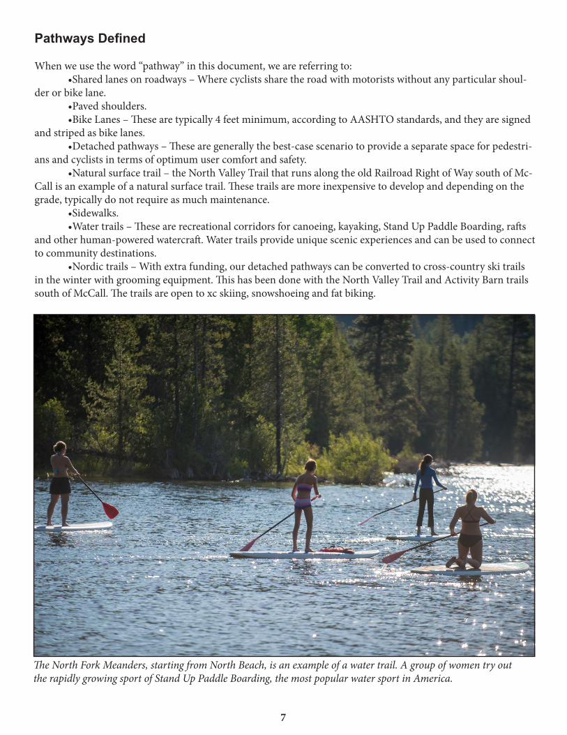
When we use the word “pathway” in this document, we are referring to: •Sharedlanesonroadways–Wherecyclistssharetheroadwithmotoristswithoutanyparticularshoul-der or bike lane. •Pavedshoulders. •BikeLanes–Thesearetypically4feetminimum,accordingtoAASHTOstandards,andtheyaresignedand striped as bike lanes. •Detachedpathways–Thesearegenerallythebest-casescenariotoprovideaseparatespaceforpedestri-ans and cyclists in terms of optimum user comfort and safety. •Naturalsurfacetrail–theNorthValleyTrailthatrunsalongtheoldRailroadRightofWaysouthofMc-Call is an example of a natural surface trail. These trails are more inexpensive to develop and depending on the grade,typicallydonotrequireasmuchmaintenance. •Sidewalks. •Watertrails–Thesearerecreationalcorridorsforcanoeing,kayaking,StandUpPaddleBoarding,raftsandotherhuman-poweredwatercraft.Watertrailsprovideuniquescenicexperiencesandcanbeusedtoconnectto community destinations. •Nordictrails–Withextrafunding,ourdetachedpathwayscanbeconvertedtocross-countryskitrailsinthewinterwithgroomingequipment.ThishasbeendonewiththeNorthValleyTrailandActivityBarntrailssouth of McCall. The trails are open to xc skiing, snowshoeing and fat biking.
The North Fork Meanders, starting from North Beach, is an example of a water trail. A group of women try out the rapidly growing sport of Stand Up Paddle Boarding, the most popular water sport in America.

8
Purpose and Need
Why is it important for Valley County to develop a valley-wide pathway system?
Research and experience related to existing pedestrian pathway and greenway systems across the United States indicate that pathways create multiple public benefits. Pathways: oCreate new opportunities for recreation and for people to commute to work or shopping areas without using fossil fuels oBoost local economies. oProvide transportation links to culturally or historically valuable areas. oTie together parks, schools, waterways and communities. oCreate opportunities for people to improve physical fitness and live healthy lifestyles. oEnhanceacommunity’squalityoflife. oPreserve open space corridors. oIncrease safety. oSave money for pedestrian commuters. oReduce traffic congestion. oCreate educational experiences as we have seen on the Boulder Creek Trail in the Fulton Natural Area in Donnelly. See more detail about these benefits in the Master Plan.
In our experience in Valley County, when new pathways have been built, people begin to use them immediately, andtheyveryquicklyprovidemultiplebenefitsintermsofaplacetoengageinhealthandfitness,recreation,transportation (commuting to work or shop) and safety benefits.
Identification of Pathway Corridors
Valley County Pathways has identified a number of proposed pathway corridors in Long Valley that would create an outstanding linked pathway system. We have updated this section, discarding old corridors that did not pan out, and adding new ones that make sense looking ahead to the future: Old Railroad Right of Way–TheOldUnionPacificRailroadRightofWayinLongValleyoffersthebest opportunity to develop a long-distance pathway in Long Valley that links together Cascade, Donnelly and McCallinaquietsettingawayfromabusyroadorhighway.ThebookendsoftheRRROWaresecured,butinthe middle, much work remains to be done. VCP needs to work with landowners on property easements and/or donations of property to secure the long-distance corridor in a way that respects private property rights and landowner long-term goals. Norwood Lane–IftheRRROWcorridordoesnotpanoutasaregionalpathwaycorridor,Norwoodis an excellent alternative for a public road thoroughfare between Lake Fork and Donnelly. “Share the Road” or “Bike Route” signage should be posted along Norwood to show people the way on this corridor. Farm to Market Road –FarmtoMarketRoadbetweenMcCallandDonnellyisapopularandscenicbicycle route. It provides access to many private homes along the road, the Jug Mountain Ranch development, Roseberry and several other historic sites. Because Farm to Market Road is a key access route to areas with public trails, such as in Jug Mountain Ranch, and to historic Roseberry, it makes sense to study this corridor as a place for a detached pathway on the east or west side of the existing road. In the meantime, “Share the Road” or “Bike Route” signage should be posted along Farm to Market Road to increase safety for cyclists and pedestrians. West Mountain Road–WestMountainRoadisanothernorth-southcorridorwherewecouldworktoward developing a detached pathway or bike lanes from the Blackhawk Development to Tamarack Falls. The

9
road is paved from McCall to Blackhawk. This corridor ties into U.S. Forest Service access points on No Business Road, No Business Saddle and No Business Lookout, and Tamarack Resort. East Roseberry Road–EitherstripedbikelanesoradetachedpathwayshouldbedevelopedbetweenDonnelly and the historic town of Roseberry on Roseberry Road. Because of the existing popularity of Farm to Market road as a bicycle destination, and the potential to develop a loop system between Farm to Market Road and the old RR ROW back to McCall, East Roseberry Road should receive priority for funding and development. West Roseberry Road–TheCityofDonnellyisworkingonadetachedbikepathalongWestRoseberryto Dawn Drive and City Beach on Lake Cascade. A longer-term goal is to develop a pathway along West Rose-berry to the existing detached pathway in the Meadows subdivision. A connection to Tamarack Falls should be made via bike lanes or a detached pathway. East Lake Fork Road–ExistingbikelaneshavebeenstripedbetweenJugMountainRanchandLakeFork on East Lake Fork Road in the past. If this road becomes a major collector, it would make sense to widen the bike lanes or work on developed a detached pathway on this section of road. West Lake Fork Road–Itmakessensetoprovidestripedbikelanesor“SharetheRoad”signageonWest Lake Fork Road to take cyclists from the old RR ROW to Lake Fork. From here, people would cross Idaho 55 and take East Lake Fork Road to Farm to Market Road, and then loop back to McCall. Shoreline of Lake Cascade –ThereisgreatpotentialtodeveloppathwaysectionsaroundLakeCascadefor two reasons: 1) The Bureau of Reclamation, a federal agency that manages the reservoir, owns substantial amounts of property around the lake, and the Boise National Forest owns substantial portions of the southwest corner of the lake; 2) The BOR is supportive of developing a pathway around Lake Cascade from a policy level. Inits2002ResourceManagementPlanforLakeCascade,theBORrecommendsRecreationObjective2.10.3:“Seek opportunities to link trail segments over time into a contiguous system that stretches completely around thereservoir(LakeCascadeRMP,Page5-36).” Connection from The Strand in Cascade to Crown Point Trail –Severalpublicroadroutesalreadyex-ist from the end of the The Strand to the Crown Point Trail and Campground. A pedestrian crossing on Idaho 55 should be identified, and then “Share the Road” or “Bike Route” signs should be posted to show people the way to Crown Point Trail via Lake Way or other routes. North Fork Payette River–InthevicinityofSmileyLaneandHartsellBridge,theNorthForkofthePayette River is bounded by several large tracts of BLM land and one tract of state land. If it is possible to develop pathways on either side of the river in this area, that may connect to the future pathway on West Mountain Road, that would be an appropriate long-term goal for the regional pathway system. Cabarton Road–CabartonRoadisaruralscenicbywayfrompointssouthofCascadetoClearCreek.A detached pathway on Cabarton Road south of Cascade would make sense because it is a very scenic corridor that eventually runs along the Payette River, and it ties into Forest Service trailheads on Snowbank Mountain, the Cabarton Water Trail, and the Snowbank road itself. If the railroad gets phased out south of Cascade, the RR ROW in this area would provide the detached pathway corridor along Cabarton Road. If the railroad does not get phased out, another option might be to create a pathway next to the rail line in the RR ROW. Connection to Adams County–ApubliccorridortyingtogetherValleyandAdamscountiesshouldbedeveloped along Fish Lake Road to Big Creek Road and the Weiser River Trail near New Meadows. The corridor should be signed with “Share the Trails” or “Bike Route” signage to increase safety for pedestrians and cyclists and show them the way. Other regional corridors will emerge as Long Valley becomes developed for housing and commercial development. Valley County Pathways and Valley County government should watch for these developments and amend the pathways concept master plan accordingly to follow growth in strategic corridors.
Goals The following is a list of goals that will help our communities achieve an overarching goal of establishing a viable and enduring pathways system in a timely manner:

10
Goal 1. The Valley County Planning and Zoning Commission should adopt the updated 2017 Valley County Pathways Master Plan and incorporate its goals and proposed pathway corridors into the Valley County Com-prehensive Plan. The plan should create a priority system for developing Class I (detached pathways) and Class II pathways (bike lanes).
Goal 2. Valley County Pathways should develop a map and brochure of the Valley County Pathway System in the early stages of development, and update the map over time, as needed, to keep it current.
Goal 3.TheValleyCountyPlanningandZoningCommissionshouldrequireindividualsanddeveloperswhopropose new developments and subdivisions to blend their proposals into the vision for a valley-wide pathways system.
Goal 4. The Valley County Planning and Zoning Commission should obtain pathway right of way easements from new developments in cases where the development overlies key pathway corridors. Such easements should be held by Valley County government or VCP.
Goal 5. Valley County Pathways should work with Valley and Adams county officials and community groups to determinehowbesttopayfortheacquisitionofeasements,fundthedevelopmentofnewpathwaysandprovideregular financial support for pathway maintenance. See next section on “Funding Opportunities for Pathways.”
Goal 6.TheValleyCountyPlanningandZoningCommissionshouldrequireindividualsanddeveloperswhoare creating new subdivisions or other developments to develop finished pathways. If a new, benevolent devel-oper chooses to build a finished pathway, following the desired statewide pathway standards, they should receive development credits in some fashion to compensate them for contributing to the valley-wide pathway system.
Goal 7. Valley County Pathways should work with existing landowners and subdivision owners to obtain tempo-rary or long-term access agreements to key pathway corridors in high-priority areas. These negotiations need to be done in a way that respects landowners’ private property rights.
Goal 8. Valley County Pathways should work with the Valley County Road and Bridge Department to collabora-tively look for opportunities to incorporate pedestrian and bicycling facilities into the design of road and bridge projects in areas where regional pathways are proposed and elsewhere.
Goal 9. In new development areas where potential links to the regional valley-wide pathway system can be estab-lished, developers should be strongly encouraged to create neighborhood pathways, bike lanes and/or sidewalks to encourage and accommodate safe pedestrian travel to regional pathways.
Goal 10. Valley County Pathways should work in a collaborate fashion with the Valley County Road and Bridge Department, Valley County schools, city governments and state parks to increase communication about the po-tential for developing pathways to create safe routes to schools and parks.
Goal 11.Valley County should create a program to provide regular maintenance, sweeping, pavement repairs, striping and signs along pathways and bike lanes.
Goal 12. Valley County Pathways should ensure that pathway master plans developed for the cities of McCall, Donnelly and Cascade and Valley County are consistent and in synch with each other and the Valley County Pathway Master Plan. So far, we are on track.
Goal 13. Valley County Pathways should maintain a design standard for pathway signage and develop a system of signs that maintain a consistent character and design. Such signs should be placed throughout the pathway
11
system as it is developed. This goal is in the implementation stage.
Recommended Implementation Schedule
Highest-priority projects: •WorkonpropertyeasementsordonationsofpropertyalongtheoldRailroadROWfromLakeForktoPine Lakes Ranch. In particular, VCP is focusing on working with property owners along the RR ROW between Lake Fork and the city of Donnelly, starting from the south and north ends and moving toward the middle. •Intheinterim,develop“SharetheRoad”or“BikeRoute”onNorwoodLanefromLakeForkRoadtoWest Roseberry Road in Donnelly, providing a public road corridor for bicyclists, walkers and trail-runners, ty-ing together the communities of Lake Fork and Donnelly. •DeveloppublicroadcorridorconnectingValleyCountytoAdamsCountyandtheWeiserRiverTrail.We have identified the Fish Lake Road and Big Creek Road as the public roads connecting a public corridor be-tween the two counties. These corridors should be signed with “Share the Road” or “Bike Route” signage to show people the way to connect to Adams County and the Weiser River Trail. •WorkondevelopingadetachedpathwayorbikelanesfromRoseberryRoadtoRoseberry(alignswithCity of Donnelly priority) and on Farm to Market Road from Roseberry to Elo Road, Krahn Lane and Sampson Trail to link Farm to Market to McCall (aligns with city of McCall priority). •WorkondevelopingadetachedpathwayonWestMountainRoadfromBlackhawktoTamarackFalls. •WorkondevelopingadetachedpathwayonWestDeinhardLanetothejunctionwiththeexistingMc-Call bike path near Mission Street. •ContinueworkingonpathwaycorridoraroundPayetteLake.New,widerbikelaneswillbebuiltonWar-ren Wagon Road on the west side of the lake in 2018. In the meantime, we recommend applying for grant funds to commission a study of building a detached pathway around the east side of Payette Lake. A study will help understand the different land ownerships and costs involved. •WorktowardmoredetachedbikepathsalongLickCreekRoadfromShadyLanetoEastSideDrive.Thisinitiative connects to the goal of building a pathway around Payette Lake. •WorktowardbuildingbikelanesoradetachedpathwayalongDavisRoadtoGoldForkHotSprings,apopular destination. •WorkwiththeBureauofReclamationandtheIdahoDepartmentofParksandRecreationtodeveloppathway corridors around Lake Cascade. A system of priorities should be developed for these potential pathway segments to determine which ones should be focused on in the near term vs. long term. •DevelopdetachedpathwaysbetweenthecityofDonnellyandTamarackFallsonWestRoseberryRoad.The City of Donnelly is working on developing a detached pathway on the south side of West Roseberry Road to Dawn Drive and the city beach as a high-priority. •DevelopadetachedpathwayalongCabartonRoadfromtheClearCreekjunctiontothecityofCascade.
Funding for Pathways Our financial section details a menu of options available for financing the development of pathways. Clearly, financing pathways has been our largest challenge. Valley County and Adams County have a small tax base to cover many needed services. Pathway advocates need to be as creative as possible and use each and every finan-cial program possible to find ways to fund pathway projects.
We hope the America’s Best Communities initiative will help stimulate further discussion about financing path-ways. And if the West Central Mountains group wins the ABC competition, we hope some of those funds could be used for pathway studies or projects. We also believe that state and federal grant programs, two-year serial levies and a possible formation of a recreation district in the northern half of Valley County all hold great prom-ise.