val geopt 2. 14867 - ontario · e val geopt 42c13sw8711 3.l1867 wabikoba lake 010 2. 14867...
TRANSCRIPT

EVALGEOPt
42C13SW8711 3.l1867 WABIKOBA LAKE 010
2. 14867
GEOPHYSICAL SURVEYSProperty of
PLACER DOME INC.#429 PROJECT NORTH LIMB
THERESA LAKEProvince of Ontario
July 1992
G. Lambert R. Turcotte
RECFIY/PD
JAN l 4 1993
MINING LANUb bHANCH
92-843
SERVICES EN LEVES GEOPHYSIQUES - GEOPHYSICAL SERVICES50, boul. Lamague, VAL D'OR (Quebec) J9P 2H6 T*l. : (819) 825-6539 Fax : (B19) 825-1342

42C13SW8711 2.14867 WABIKOBA LAKE 010G
i
TABLE OF CONTENTS
Page
Table of contents......................................... iIntroduction.............................................. lProperty, location and access............................. lGeophysical surveys.......................................lSurvey specifications.....................................2Results and Interpretation................................2Conclusion and recommendations............................4Certificates............................................6-7
LIST OF FIGURES:
Figure #1: Index of claims and area surveyed.............ii
LIST OF MAPS:
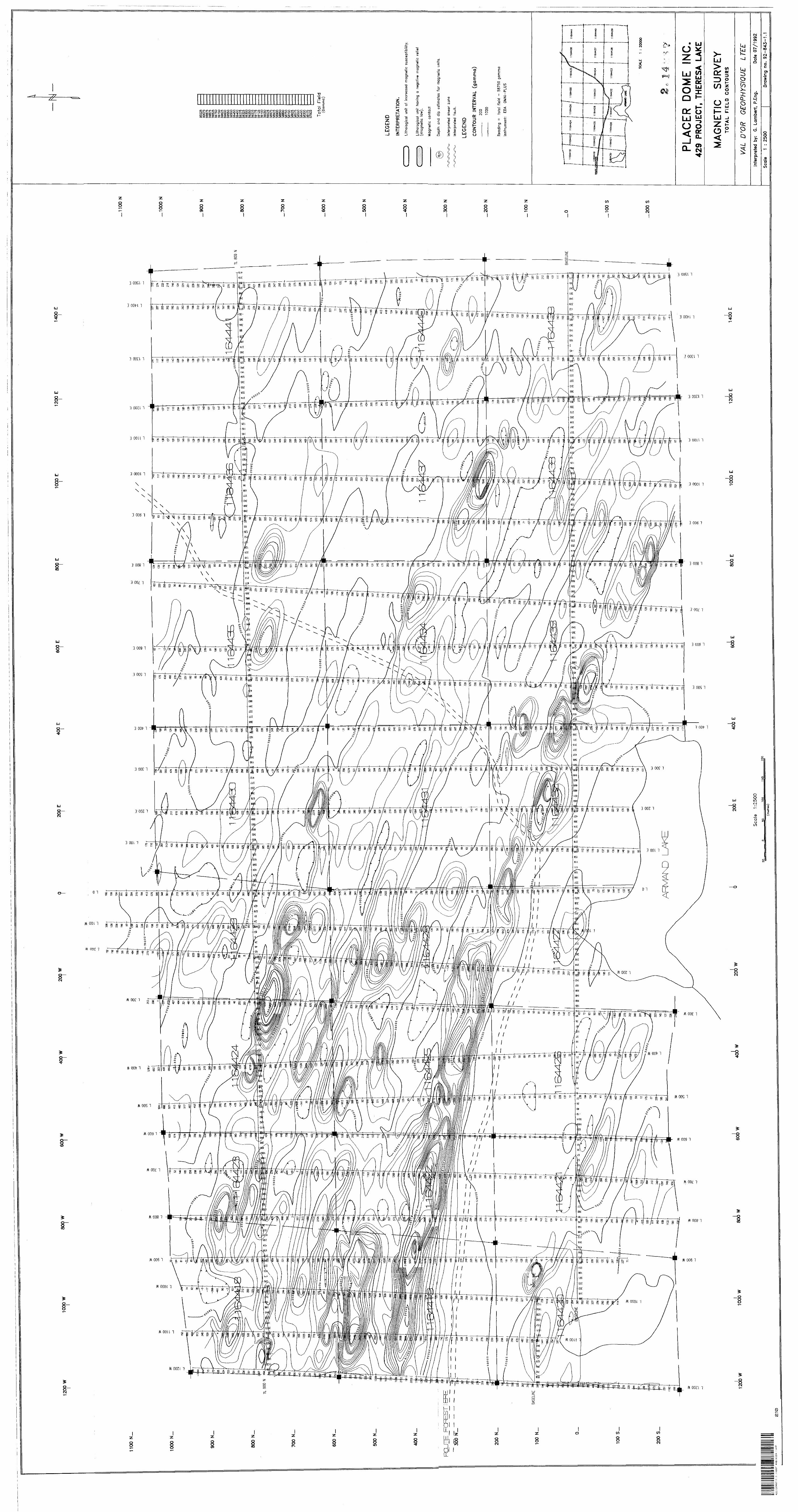
DRAWING NO. MAGNETIC SURVEY
1.1 Total Field Contours1.2 Total Field Profiles
DRAWING NO. VLF-EM SURVEY
2.1 NAA Profiles

-11-
SCALE 1 : 20000
PLACER DOME INC.
#429 PROJECT NORTH LIMB
THERESA LAKE Figure #1: Index of claims and area surveyed

-1-
INTRODUCTION
In July 1992, magnetic and electromagnetic surveys
were carried out on a property owned by PLACER DOME INC.,
#429 PROJECT NORTH LIMB, THERESA LAKE property, Province Of Ontario.
These surveys were designed to locate structures
favorable for gold or base metal deposition.
PROPERTY, LOCATION AND ACCESS
The property is located approximately 45 kms North west of the town of White River, and approximately 18 kms
North-East of the town of Hemlo.
The property is accessible from the town of White River along Highway #17 West, and then for about 14 kms on
Highway #614 North towards the town of Manitouwage.
The property claims have been registered with the
Ontario Ministry of Natural Ressources and their numbers
are presented on the figure #1 of this report.
GEOPHYSICAL SURVEYS
A magnetic survey and an electromagnetic VLF-EM survey
were carried out on the property on July 1st to 3rd, 1992.
A total of 39.9 kms was covered by the magnetic and electromagnetic surveys using EDA OMNI-PLUS units.

-2-
SURVEY SPECIFICATIONS
The geophysical surveys were carried out along a network of N-S oriented grid lines cut at a 100-metre interval. The lines were chained and stations marked every 25 metres.
The magnetic readings were taken with a proton precession magnetometer recording the value of the total magnetic field with a precision of 0.1 nanoTesla (nT). The
readings were taken systematically every 12.5 metres. The corrections for the diurnal variation were done using the
values recorded by a. base station located on the property.
The electromagnetic VLF-EM surveys were carried out with measurements of the in-phase and out-of-phase
components of the vertical field with a precision of It of
the primary horizontal field. Readings were taken
systematically every 12.5 metres using the NAA transmitting
station (24.0 kHertz; Cutler, MA) for the crosslines, and
NSS transmitting stations (21.4 kHertz; Annapolis, MD) for the base and tie lines.
RESULTS AND INTERPRETATION
The magnetic data indicate a background level of about 58750 gammas. This background is fairly active however, as
can be seen on the magnetic profile map.

-3-
More than two-thirds of the survey area is characterized by active magnetism, with anomalies (having
mean amplitudes of 500 to 2000 gammas above background) probably caused by the presence of mafic lithological
units, such as basaltic flows or gabbro sills. The dominant strike direction of these units is WNW-ESE. The magnetic units appear to be thin, planar and sub-vertically dipping. They are fairly continuous and un-interrupted
along strike.
Bands of quiet, unperturbed magnetic relief exist,
particularly in the southwest portion of the property. In
that area, an interpreted sedimentary units (or, less probably, a felsic volcanic unit) appears to occur in an
area of low magnetic activity.
Judging from the wavelengths of the magnetic
responses, the magnetic sources are generally shallow,
typically less that 10-15 metres depth to top and often less than 5 metres. It is thus reasonable to speculate that most magnetic units subcrop near surface.
The VLF-EM profiles show the occurrence of several conductive bands also striking WNW-ESE, parallel to the magnetic trends. The background noise level of the VLF data is quite small, indicating generally resistive, electrically "clean" rocks and very thin overburden cover.
Most VLF conductors are continuous along strike,
particularly conductors "A" and "B" (please refer to the VLF profile map). Although the VLF method has a limited

-4-
discriminating ability, it appears probable that almost every conductive band interpreted is of metallic nature (sulphides or graphite).
Most VLF conductors appear to be associated with the magnetic units. Conductor "A" follows the northern contact
of the interpreted sedimentary band in contact with mafic rocks. There is a good chance that Pyrrhotite is present at least in minor quantities in the magnetic conductors. Interpreted depths from the VLF data also indicate generally shallow sources.
CONCLUSION AND RECOMMENDATIONS
The ground geophysical surveys which were performed on
the THERESA LAKE property have successfully mapped a mostly mafic lithological assemblage striking WNW-ESE with units
at generally shallow depths and hosting a number of
sedimentary intercalations of low magnetic susceptibility.
Metallic bedrock conductors, also at shallow depths and conformable with the stratigraphy, were mapped mainly
inside the mafic rocks.
The good continuity along strike of both the magnetic and conductive bands suggests a structurally monotonous geological environment.

-5-
Recommending future work, we believe that the property should be first mapped and prospected. This work will probably allow to explain several anomalous features.
Not having any geological Information at this point makes it difficult for the writer to define a priority level to the geophysical anomalies. But we do believe that the interpreted metallic nature of many of the VLF conductors offer some potential for locating mineralized sulphides.
Those conductors situated in geologically "favourable" horizons should be further investigated at depth with diamond drilling, aiming at first for the -100m level.
Respectfully submitted,
VAL D'OR GEOPHYSIQUE
Consulting Geophysicist
and by:Robert
GERARD LAMBERT(jEOSCIENCES Sociftf de consultation et de gtnie-conseil en giophysique.
-6-
CERTIFICATE
I, undersigned, Gerard Lambert, P. Eng., certify that:
l reside at 2158, des Coteaux, C.P. 2355, Rouyn-Noranda, Quebec, since 1983.
I am a graduate of Laval University, Quebec where I have obtained a B.Se.A. in Geological engineering in 1978.
I have been engaged in Exploration Geophysics since 1972 and have been practicing as a professional engineer since 1978.
I am a member of the Ordre des Ingenieur du Quebec since 1978.
I am a member of the Quebec Prospector Association, the Prospector ft Developers Association of Canada, the Society of Exploration Geophysicist, the European Association of Exploration Geophysicists and the Canadian Institute of Mining R Metallurgy.
This report is based on the information contained in the survey described. The interpretation of the data was made using methods known in the literature and based on my personnal experience.
I have not received, nor do I expect to receive directly or indirectly any interest in the claims that belong to PLACER DOME INC.
Rouyn-Noranda, this July 16, 1992
Gerard Lambert, P. Eng. Consulting Geophysicist
2/58, des Coteaux. C.P. 2355, Rouyn-Noranda (Quibec) Canada J9X 5A9 Telephone: (819) 762-3182 Teltcopieur. (819) 762-5364

-7-
CERTIFICATE
THIS IS TO CERTIFY THAT:
I am a resident of Val d'Or, Province of Quebec, since 1977.
I am a technologist graduated from "College du Nord-
Ouest", Rouyn, Quebec in 1977.
I have been actively engaged in geophysical exploration since 1977 and have acquired a wide range of experience in
geophysical methods and techniques.
I am a member of "Corporation professionnelle des Technologues des Sciences Appliquees du Quebec" and also a
member of the Quebec Prospectors Association and of the Canadian Institute of Mining and Metallurgy.
I do not hold nor do I expect to receive an interest of any
kind in these claims held by PLACER DOME INC.
Signed in Val d'Or, this July 16, 1992.
Robert

itario 42CI3SW871I 2.!4867 WABIKOBA LAKE 900
Ministry of Ministere duNorthern Development Developpement du Nordand Mines et des Mines
February 15, 1993
Mining Lands Branch Geoscience Approvals Section 933 Ramsey Lake Road 6th Floor Sudbury, Ontario P3E 6B5
Telephone: (705) 670-5853 Fax: (705) 670-5863
Our File: 2. 14867 Transaction #W9340. 00004
Mining RecorderMinistry of Northern Developmentand Mines435 James Street SouthSuite B003Thunder Bay, OntarioP7E 6E3
Dear Si r /Madam:
Subject: APPROVAL OF ASSESSMENT WORK CREDITS ON MINING CLAIMS TB. 1164418 ET AL. IN WABIKOBAB LAKE
The assessment work credits for the Geophysical survey filed under Section 14 of the Mining Act Regulations have been approved.
The approval date is February 10, 1993. t
Please indicate this approval on your records.
If you have any questions regarding this correspondence contact Ted Anderson of the Mining Lands Branch at (705) 670-5856.
Yours sincerely,
Mark Hall(Acting) Senior Manager, Mining Lands BraMines and Minerals Division
ONTARIO GEOLOGICAL SURVEY
ac h
Enclosures:
cc: Resident GeologistThunder Bay, Ontario
/Assessment Files Library Toronto, Ontario

H^L.Northern Development Mines * Kr ' i
Onte/teanOM•
Tranaaopon Nmnbar,Re^o1rt jof Work Conducted After Recording Claim
MiningImdertTttaulriorttyoftnaMlnlr^AfltTr^
tMa coiactton should be draotad lo the Provincial Manager, MMng Lands, MWatry ot Northern Development and Mlnaa, Fourth Floor, IBS Cadar Straat, Sudbury. Ontario, P3E SAS,'telephone (706) 670-7284. ^
or prim and submit In duplicate. ** * l * O ( - Refer to the Mining Act and Regulations tor requirements of Whig assessment work or consult the Mining
Recorder. . f* \f :. 'A separate copy of this form must be compleTed Tor each Work Group. c-' - Technical reports and maps mtfst accompany this form In duplicate.
1; A sketch, showing the claims the work Is assigned to, must accompany this form.
DOME INC. 182746
e- 3500; BOX 350; Toweri T-D Centre; Toronto Ont. M5K 1N3 (416 868-6060, n .. , ;
Thunder" Bav - Wabikoba b LakeM or O Plan No.
G 620To:
July 30/1992
Work Performed (Check One Work Group Only)Work Group Type
.Qeotschnlcal Survey- - Geohsical Survey: Val D 1 OR GeoDhvs1aue;50. boul.Lamaaue. Val d'Or. OuePtweteeJ Work, ,: Inchxang DnUng y
' Rehabilitation' -' v;. fi
OMtei Authortwd RECI to Co
JAN 14 1993Assionmenl from - ,."
1 .--.{y-M^ t-. Ci
TotaJ Assessment on the .Attached Statement of CosteNot*:* The Minister may reject for assessment work credit ail or part of the assessment work submitted if trie' nxkirded
holder cannot'verify expenditures claimed in the statement of costs within 30 days of a requsM for~verifteation.^ ., ' ' : vJ-- ^' -
Persons and Survey Company Who Performed the Work (Give Name and Address of Author of Report)Name Address
no (;n t val rf' n*- ftnph*r .IQP
f(etteeh e echeduie If neeeesary)
'-v.*x ' 'f*?^.-.'.. -Certification of Beneficial Interest * See Note No. 1 on reverse side
l certify that at the time *e work waa performed, the dalma covered In thto work report pare raoordad In the currant hokJar'a name or held under a banaWallniartat by tha currant raoorded hoMar.____fe________________
January 8/93 M.L.
CerHtleatiofl of Work Reportl eerWy that l have a personal knowledge of the facts set forth In this Work raport, having performed the work or witnessed sama during and/or alter He completion and annexed report la true. __________________________
Nama and AddraM of Parwn CMWylno ., :. .Mara Mat 1 sons; As above - Placer Dome Inc.
Totoportt No.
. (416) 868 6060 January 8/1993CtrWM By (Slgnttura)
sflr Offlce Use Only
0*1*4*1)

Ontario
Ministry offcli. j*fc mmm ftmt tmlt*mim*i^NOnnom DOVOIOpmoniand Mines
duk,*ve4opp*ment du Nord at des
Statement of Cost* for Assessment Credit
fetat des eoQts tux fins du crtdlt devaluation
Mining Act/Lot sur tot mines
Transaction NoJN* d* transaction
Personal Information ooltoctad on Into form to obtain*) undor tho authority of the Mning Act. Thto Information will b* used to maintain a raoord and ongoing atatua of tha mining clalm(s). Quoitlons about thto ooltoctlon should b* Erected to tho Provincial Manager, Minings Unda, Mlntotry of Northam Development and MlnM, 4th Roof, 159 Cadar Straat, Sudbury, Ontario P36 6AS, taiaphona (70S) 670-7264.
Laa ranaaignamanta paraonnato oontanus dana la present* formula aont racoaWto an vartu da to Lo) aur tea mlnaa at servlront a (anlr a (our un ragtotra daa oonoaaalona mintaras. Adraaaar touta quaaHon aur la ooitooo da oaaranaaignamanta au chat provincial daa tarraina mmtore, ministers du Devetoppemont du Nord at daa Mlnaa, 169, ma Cadar, 4* ataga, Sudbury (Ontario) P3E 6A6, taiaphona (706) 670-7264.
1. Direct Coats/CoOta dlrtota
Type
Wagee
and Conauttant'a
f\*arirtrE*l*va*uwcnpuon
Labour Maln-d'oeuvreField Supervision Supervtoton sur to terrain
Line cutting
Magi EM-VLF surve
"yp*
RECEIVJAN l 4
MIK
Amount Mordant
(1566.46
59363.4
14788.
l) recta
2. Indirect Coata/CoOta Indlracta** Mole: Whan claiming Rehabilitation work Indto i ara not
allowable as assessment work. Pour to rambouraemem des travaux da rehabilitation, toe coots Indirect* ne aont pas admtosMes en tent que travaux d'evaluatlon.
Type
Transportation Transport
Food and
Oeserlptlon
Typ*
C'.
Amount 1 Totato Montant Total global
1*972.74
M 52744.00
Sub Total of Indirect Coata Total partial daa coots Indlracta
Amount Aftowabto (not greater then MM of Direct Costa)
Total Velu* of Assessment CredN Vatour totato du ctedN (Total*! Otraet and Aiawath fevskjatka bidb*ct M*tSj (IOSM4N
l ~
f- -i -"'-a -
n
Not*: The raeordad hokJar will ba raqulrad to varlfy expenditures dalmad In thto atatamant of coats wHhin 30 days of a raquaat for verification. M verification to not mad*, tha Mlntotar may reject for aMasamant work aX or part of tha asaasamant work submHtad.
Not*: UtltuWrs*nregistrts*r*tsnuds verifier tos dtp*to present Mat das coott dana tea 30 Jours survant una damanda li cat affat. SI to variflcation n'aat paa affactuaa. to mlntotra paul rajatar tout ou una partto das travaux d'4valuatJon prasantas.
piacounts
W(Xkfil*dwhhlntwoyeaf8ofcornplatkX)todalrnedat100'M)Ol tha abov* Total Value of Assessment Credit.
Remleee pour tttpAt
1. Las travaux dtpoeay dans toe deux ana suKmnt tour achevement aont remboursas A 100 H da to vatour totato susmentlonnaa du crWKfavaKjaton.
l. Work filed three, tour or flve years after completion le claimed at SOtt of the above Total Value of Assessment Credit. See ceJculatlona betow:
Total value of AMMtmtnt crewx 0.50 -
2. Lee travaux dApgaastroto.quatraoudnq era aprea tour achevement aont rembouraea a 60 H d* to valeur totato du crMit d'evaluatkxi auementJonn*. Volr toe eateuto d-dasaoua.
Vatour Mate dg cntdtt d'avaluatlon Evaluation total* demands*x 0.50 -
Certification Verifying Statement of Coste
, hereby certify:that the amounts shown are as accurate as possible and these costs
Incurred while conducting assessment work on the lands shownon tha accompanying Report of Work form.
fc-M Land ManagertMsl (HP ^_____ ___ - - -r(fteoorctod HoM*r, Aotni, Position In Company)
o make this certification
Attestation da I'atat daa coOta
J'atteste par la present* :qua las montants Indlques sont la ptue exact possible et que ces depenses ont M ertgagees pour effectuer lee travaux d'avaluation aur lea terrains Indlques dans la formula de rapport de travail cHoint.
Et qu'4 tJtre da je suls autortoe(ttUWra wwigtetr*, rapriMnUvM, pott* occup* dm to oomp*gnl*)
a falra catte attestation.
Nota: OaiM can* fonnuto, ktraqu'l dtolon* d** pmonn**, to mucuNn **t utllM au tww nMr*.

Mo. 101/08/1993
Work Report uetoer for
Total
CLAIM
NUMBER
TB 116U18 Tt 116*419 Tl 1164420 Tt 1164421
Tt 1164422 Tt 1164425 Tt 1164424 Tt 1164425 Tt 1164426 Tt 1164427
Tt 1164428
Tt 1164429
Tt 1164430 Tt 1164431
Tt 1164432 Tt 1164433
Tt 1164434
Tt 1164435
Tt 1164436
Tt 1164437
Tt 1164439 Tt 1164439
Tt 1164440 Tt 1164441
SCHEDULEREPORT OF UORK CONDUCTED
AFTER RECORDING CLAIM
Value of
ofClalei
Unite
Work Dam on thU data
800.00800.00800.00800.00
800.00
800.00800.00800.00800.00800.00
800.00
800.00
800.00800.00800.00800.00
800.00800.00
800.00
800.00800.00
800.00800.00462.00
18862.00
QUJ S3> * rsiUJ ^
Value O ^Wliad H! -J:o thle ff-
Clalei
800.00800.00800.00800.00800.00800.00800.00800.00800.00800.00800.00800.00800.00800.00800.00800.00800.00800.00800.00800.00800.00800.00800.00462.00
DCO
|FCDCO O
1g.
Valueilgned
fro* ClalM
0.000.000.000.000.000.000.000.000.000.000.000.000.000.000.000.000.000.000.000.000.000.000.000.00
18862.00 0.00
Reserve:
york to beClaimed at
Future Date
0.000.000.00o.do0.000.000.000.000.00
0.000.000.00
0.00
0.00
0.000.00
0.000.00
0.000.000.00
0.000.00
0.00
0.00
Ha/

Major Benefits of the OMNI PLUS* combined VLF/Magnetometer/cradlometer
System
* No Orientation Required
* Three VLF Magnetic Parameters Recorded
* Automatic calculation of Fraser Filter
0 Calculation of Ellipticity
* Automatic Correction of Primary Field Variations
9 Measurement of VLF Electric Field
to^- -

j educations*equency Tuning Range.
admitting stations Measured.
, 15 to 30 kHz, with bandwidth of 150 HZ; tuning range accommodates new Puerto Rico station at 28.5 kHz
. Up to S stations can be automatically measured at any given grid location within frequency tuning range
etorded VLF Magnetic Parameters .,...,.......... .Total field strength, total dip, vertical
quadrature (or alternately, horizontal amplitude)
tandard Memory capacity..... .800 combined VIF magnetic and VLF electricmeasurements as well as gradiometer and magnetometer readings
Hsplay ...,....,............. .Custom designed, ruggedlzed liquid crystaldisplay with built-in heater and an operating temperature range from -40'C to -f 55*C. The display contains six numeric digits, decimal
f point, battery status monitor, signal strength ( status monitor and function descriptors.
?S232C Serial I/O interface ...... 2400 baud rate, 8 data tt] ts, 2 stop bits, no parity
est Mode .........,..,....... A. Diagnostic Testing (data and programmablememory)
B. self Test (hardware)
.en*or Head .......,.....,... .contains 3 orthogonally mounted coils withautomatic tilt compensation
operating Environmental Range ...................... -40*cto *55*C;
O - 1(XW relative humidity; weatherproof
Power Supply ................. Non-magnetic rechargeable sealed lead-acid 18VDC battery cartridge or belt; 18V DC disposable battery belt; 12V DC external power source for base station operation only.
weights and Dimensions instrument console .......... 2.8 kg, 128 x 150 x 250 mmSensor Head....... .........2.1 kg, I30dla.xl30mm . ,VLF Electronics Module........ 1.1 kg, 40 x 150 x 250 mmLead Acid Battery Cartridge ... 1.8 kg, 255 x 105 x 90 mm Lead Add Battery Belt........ 1.8 kg. 540 x 100 x 40 mmDisposable Battery Belt ....... 1.2 kg, 540 x 100 x 40 mm
IDA instrument* me.. 4 Thor neill rt Park orlvt. Tor onto, Ontario Canada M4H1H1Telex: 06 7 JIM IDA TO*.Cable* instruments Toronto (416)42*7100
in USA,EDA instruments tot. S1S1 ward toad, wheat Ridge. Colorado U.SA eooJi1)094224112
Printed in canada
TT:

riptlonANt PLUS" geophysical combines the OMNI iv
i6M magnetometer and neter together with a VLF cement capability. INI PLUS VLF/Magneto- System has been develop- o-opcratlon with Geo- al Surveys inc. of Quebec, a.rochure concentrates on JF magnetic and electric wrameters measured and ded by the OMNI PLUS. More tuition on the OMNI PLUS .etometer system and tie- apablllty Is available in the IV brochure.
lituresOMNI PLUS incorporates the
i wing features:sasurement and recording in emory of the following VLF )ta for each field reading: total field strength, total dip,vertical quadrature or, alternately, horizontal amplitude,
l apparent resistivity, phase angle, time,grid co-ordinates, direction of travel along grid Ones, andnatural and cultural features.
:omplete data protection for a number of years by an internal lithium backup battery.
l Tje-Une" or "Looping" TOrtthm, unique only to )f ^MNI rv and OMNI PLUS
wer., . for the self-correction of atmospheric variations and variations in the primary field from the VLF transmitter.
Measurement of up to three VLF transmitting stations to provide complete coverage of an anomaly regardless of the orientation of the survey grid or of the anomaly itself. Display descriptors to monitor the quality of the VLF signal being measured. Choice of three data storage modes:- spot record, for readings without grid co-ordinates
- multi record, for multiple readings at one station
- auto record, for automatic update of station number
Output of grid co-ordinates with the designated compass bearing, using N, S, E, W descriptors.
Major Benefits* Combined VlF/Magneto
meter 7 Gradiometer SystemThe OMNI PLUS incorporates the capabilities of the OMNI lv "Tie- Line" Magnetometer and Gradiometer System with the ability to measure the VLF magnetic and electric fields.Oniy one OMNI PLUS is needed to record all of the following geophysical parameters:
1. The total magnetic field2. The simultaneous gradient of
the total magnetic field5. The VLF magnetic field,
including:- the total dip- the total field strength of the VLF magnetic field
- the vertical quadrature, or alternately, the horizontal amplitude
4. The VLF electric field,including:- the phase angle- apparent resistivity
AS an example, at each location the OMNI PLUS can calculate and
record In a matter of seconds, three VLF magnetic field and two VLF electric field parameters from two different transmitters, a magnetic total field reading and a simultaneous magnetic gradient reading.
No Orientation RequiredThe OMNI PLUS requires no orientation, by the operator, of the sensor head toward the transmitter station. This simplifies field procedures as well as saving considerable survey time. When two VLF transmitters are measured, the benefits of this time-saving feature are auto matically doubled. There Is no requirement for the operator to orient himself and the sensor head toward the first selected transmitting station and then re orient towards the second trans mitting station.consistent high quality data is achieved In the OMNI PLUS due to the utilization of three ortho gonal sensor colls rather than two sensor coils used in conventional systems. The quality of data is not then dependent on the operators ability to correctly orient the sensor head for optimum coupling with the transmitting station.The OMNI PLUS compensates automatically for the direction of travel along the grid lines as welt as for the angle of the sensors from the vertical plane through the use of tiltmeter*.
Three VUF Magnetic Parameters RecordedThe OMNI PLUS calculates and records in memory the:-total dip- total field strength- vertical quadrature The operator has the option to substitute the horizontal amplitude for the vertical

LEGENDBLACK RIVER G-580
; U'L l iM Si-:,. BASf LtM
LOTS, WININC CLAIMS.
LllttS LO"
PARt.t l POUN! .*H v
, jrr^^---Hi*M^ \=7 .. .t- .u .-v K
.144059 . NPINE irove/r^ P? t . ., J ..- 4 - - l - -rJ
P L65OSS,r i
1172531 l 1172990 ] 1172889 ' l 1 DISPOSITION DFCHOWfi
l\!172530 1172891 1172692 i (72529 TYPE Of DOCL'MLfJT——— " -*"" ~~ ——— ——— -4 ——— ——— —— - ——J- ——— ——— - ——— —— . [Q ^-
1 l APA'H N1 bUf-, i /-' f .\ .
Aft ^ p" IS OM
MtNlf, . !.M,M", fiM N
l LASE SUMf ^ri f VlM'.'i. l .lil
. ' Ihl AC l HIGH l!, (JNl '
, f K,M ' ', ( j'v. ('
LICFNCt Oi ()f;(.,UtY--i ION
f' IN .,UUN(Ml
Rf '.: f
CANC! L ' M)
SAND ^ GHA. !AND U.',|: ('f HM
l II8II32 , -I7YB80 , l|77a77
1*83292' ' H8329IBII39 , IIBII34 |IT7**B | ,| 77 f.
f,'..; i f i I;-':H 4M c HAt'J*0 j -177*61 -ITTiW l ||402 sai
'
SOLO N G L AK^ SUbJ 1 '/T K, f- l ' if j'.,V - ', K
Os 'iurround*d by ThiaEoi*rn*nt JC84-IO.
S** Bomby Laidroll,
muse .IISM57 nans* ualis*ands Surroundtd by TNt Morklrig ir* f. p jbj*ct to
Mooing and athwr right i, as /*r S*--. lfl9 * .T.-.1 S.- WMl* l ah* N. PVT '"" TT ~~
tT B 1TB~- -4 - - K- -h
TB /' ''TP
:':" H40655 ' 1)406^6
^ L -^7- J. -
1173759 hi73736 l 11757351S47781 142843 ||42844 "42B45
i BULLRINGTHE INFORMATION THAT APPEARS ON THIS MAP HAS BEEN COMPILED FROM VARIOUS SOURCES. AND ACCURACY IS NOT GUARANTEED. THOSE WISHING TO STAKE MIN ING CLAIMS SHOULD CON SULT WITH THE MINING RECORDER, MINISTRY OF NORTHERN DEVELOP MENT AND MINES. FOR AD DITIONAL INFORMATION ON THE STATUS OF THE LANDS SHOWN HEREON.
__ CJ - ^ _'^_ - J~-\- - -
~
-B ITB \ l ta-
WABIKOBA LAKETB i TB ITBIOS03?6 l '050325 '
TB ITB l TB ' TB
1080568 ' IOaos7i ' i0503?Cff^-m .-.*
M.N.R. ADMINISTRATIVE DISTRICT
TERRACF. BAYMIMING DIVISION
THUNDER BAYLAND TITLES/ REGISTRY DIVISION
THUNDER BAY
" "~
-4*3 WMt- - XI- .^--1- -L - 4- - - l- - ^- . - ^5 8579ifiy58378
T B l T b TB~ ~ ~
[M74864l 13 JTJ P ̂ T l r* 1** ' -
'650 557 ' 6 'ha 1 - ,fcilTp'?w,i}4 ;.e?o..i6 IT
Ministryof LandNaturalfv^ M ; .-- '\-l_lvi i
~,T "tP:-'Oi73S, it-r r*j '-.. t*r!0 l jf- S ' \ B ' - A .
, - -J. ^ 54,615123
BOMBY TWP. G-3173 PROTHER^ TWP. G-317242C13SW8711 2.14667 WABIKOBA LAKE G-620
Z/— .u. E— E
CL 0) O LO
cCT)OE -o(D M O O)
—— O
Z O
a-z.UJOLU
LJ tta. o: LU o
-C
c en o
o o
en
8.2
P oS: E
-o c o
aO)o
D (D
-C M
oO)
o. o "c
e-a
Q "Z.LJOLU
OEE oO)
o:uth-
O
O(J
oo o o otN --
o EE oen Oin^; oo
2 2 o) O
I 2
ii
•1——- l f
rxl
\ 5l s
go o
~\
o: LUO o
Q.
LUw tf
O
LUZ O
O O
a-iLU
o
CM O) O)
o
os3: o,apQ
CO
O)4oc
O)c"ia a
O*C
LJ
Eo
o o in"O fi)
CLk. OC
-2 o o
O O 8
z o
en
Zo8
z o
z o Oo
too o
COo pCM
3 0051 1
3 QQSL l
3 00*1 l
3 OOH l
3 (TO l 3 ooei i
UJ8- 3 OOZl l
3 OOtl l
LJoO"o 3 OOOL l
LU O—
S
UJ-
SOOt l
LU O-
O—
M OOL l
M ODC
8-o
S S s 8/g l g s
-8
LU
CM
LU O"8
LU-800
LU
UJ
UJ"g(M
O OinCN|
o
—o
-ooCM
-o oCO
-8O
M 002
8OQZi l
Qoi
o o
lz
8O*

CDC D) OE
-oCD Vi D CD
Z -52 -o^ ^
c co ts
O O)
O)c
DJZ
ozUl OLJ
o: o. o:LJ
g o)
o.c
DI O) .0 C O f
i E
o"S c en O
"DcD
Q. CD O
DEE oD)
Ooun
CD C O NL.o ±: ® n-C O w -^T3 "O V Q)"g "ge- effi CO-*— -*-c c
(Ou-
O IZ CE — Q. D
OO l~I— UJ Z O
Oin
32O)
10CO
a -a E^ EiZ a
en
CO
enc5 "S
O) COa: a:
88N
O 00
LI..
O
UJ
Qtt: oLdO o
a
Ld
(O
O
LJ ZO
Df Q.
Q-J UJU.
o
O Q -J
CMenO)
ov"5
t 0)J*E o
o
"D 0)"EQ.u O)"c
00l
CM O)
dcD*c"ia
o o inCM
o o
•z.
8O)
"2L
OZosl
z o O
O
tn o
3 0091 l
LJ
O
LJ
8CM
O O LO CM
Jl)D U
CO
0 ft](U

E
o
T)
-D
5-S
-o tf -I sE TJ
* l-*- O)o >(D O
"fc(D ^v- C
le .5O. XID o ,-k. -*- WCD u ( o
i. "
o.y ~O "w "S o!——— ™ *D W
CizLdO Ld
' W< t-Ulo: o.
O 01 — C -
(j) en
Oa:
(- \ l l-1
0)a:
O
2? E
M .tr ?s^ ,Q-"G w
5 i
' 3.2-2D C -t V-u o-^oB 0 2 m l ^S-E
eM v iS * *- -fck- CD O W
J5 .9--5
- E ;-— '-m(T —
-0 5
oi
o3 O n O
-1C*
-S - 2-c "w .2CD D
"O C
E2 O"o13
TD C Oo
-p(D .O
a
-ocD
(P (J C D
XJCo o
KO
O (N C-J
E l o
l
^ CD
D-C O-
0}w o-C Q.
S"^ ^S 2 o..-O O)Ci Q. d
U (Ac en
C 4) C
Q)ce
O WJc entt C
CL lc
r- i-i-TJ
co
(/lenc^ Oa tt
^ :D-i a.
21 2 O
<O
/'iJ
6
D
O
Q
Ld O 0
a. S
to
u.: oa: a.
LiJ21 O
O
L*4
[i!
O
Q.O
Oso*\
Q -J
CM O) O)
r** oO)"5o
D)C UtQL
v*
O) JOEo
o
3^-Q
T3 0)
B*B
(P
D-k- 0)C
CMl
K) ^1- COl
CM O)
ocD)C'5D O
O OinCM
Oo o oen
z o
Z O os? s? o o
too o
COo
3 0051
3 0051 l
Ld O
3 00*1 l
oon i
3 ooa i 3 00ft 1
ui8- 3 OOZl l
3 oo^^ i
3 OOH l 3 ooin
LJ O
OOOL l
3 006 l
LJ C3-
UJo-
LUS"
O l
M 001 l
M 001 l
o- S
*o.
UJ O
Ul
8(N
UlO"OO
Ul -Oo00
Ul-o
Ul-o
Ul-os
o o in(N
a y to
3:-o
-o o(O
M
M
.Oo o
M 001
M QOZl
M OOZt l
Q 0) (U
8