uttarakhand rural water supply and environmental sanitation...
TRANSCRIPT

UTTARAKHAND RURAL WATER SUPPLY AND ENVIRONMENTAL SANITATION PROJECT(SECTOR PROGRAM)
ENVIRONMENTAL MANAGEMENT FRAMEWORK
STATE WATER AND SANITATION MISSIONPROJECT MANAGEMENT UNIT,
DEPARTMENT OF DRINKING WATER, GOVT. OF UTTARAKHAND,
MUSSOORIE DIVERSION ROAD, MAKKAWALA, DEHRADUN
SEPTEMBER 2005
Page 1 of 51
Uttarakhand

TABLE OF CONTENTS
ENVIRONMENTAL MANAGEMENT FRAMEWORK
Page Number
1.0 Introduction-------------------------------------------------------------------------------------------61.1 Public Consultations & Disclosure--------------------------------------------------------7
2.0 Major Environmental Issues-----------------------------------------------------------------------82.1 Water Quantity Issues----------------------------------------------------------------------10
2.1.1 Large scale degradation of macro-micro catchment--------------------------102.1.2 Uncontrolled and over grazing on catchments---------------------------------102.1.3 Fuel wood Pressure on Catchments---------------------------------------------10
2.2 Water Quality Issues------------------------------------------------------------------------11
2.3 Program Specific other Issues-------------------------------------------------------------112.3.1 Possible impact on down stream ecosystem and settlements----------------112.3.2 Possible impact on ecological resources---------------------------------------122.3.3 Possible impacts on land-use and topography---------------------------------12
2.4 Possible impact due to inadequate environmental sanitation--------------------------12
3.0 Environmental Management Measures---------------------------------------------------------13 3.1 Management Measures for Source Protection & its Sustainability-------------------19
3.1.1 Management of Large scale degradation in mini-catchment areas---------20 3.1.2 Management of Uncontrolled and over grazing in catchments-------------21 3.1.3 Management of Fuel wood Pressure--------------------------------------------21
3.2 Management of Water Quality Issues----------------------------------------------------21
3.3 Management of Project specific other issues-------------------------------------------24 3.3.1 Possible impact on down stream ecosystem and settlements---------------24 3.3.2 Possible impact on ecological resources---------------------------------------24 3.3.3 Possible Impacts on land-use and topography--------------------------------24 3.3.4 Possible impact due to inadequate environmental sanitation----------------24
4.0 Institutional Arrangements -----------------------------------------------------------------------254.1 Management Plan for source centered
catchment area conservation and management program------------------------------26 4.2 Monitoring and Performance Tracking of source centered CACMP----------------274.3 Fund Flow arrangements for the implementing/mitigating
source centered catchment area treatment work---------------------------------------28 4.4 Capacity Building and Training----------------------------------------------------------29
5. 0 Screening Guidelines for Environmental Issues & Safe Guard Measures--------------30
6.0 Risk Factors------------------------------------------------------------------------------------------31
Page 2 of 51

ANNEXURE 1: Guidelines/ Environmental Codes of Practices For:
i. Identification of Sources for water supplyii. Protecting Surface Water Supply Source and Ensuring its Sustainability
iii. Protecting Ground Water Supply Sources and Ensuring its Sustainabilityiv. Water Quality Monitoringv. Selection Of Safe Sanitation Technology Options
(Including Drainage) at individual Household and Community Levelvi. Selection Of Location For Community Toilets
vii. Safe Sullage Disposal And Organic Waste Managementviii. Safe Solid Waste Management At Individual Household
And Community Level
ANNEXURE 2: Forest Land Transfer on lease for construction of drinking water supply schemes
ANNEXURE 3: Tables Showing Cost for Source Centred Treatment for One Water Supply source/Scheme under Catchment Area Conservation and Management Program with detail specifications
Page 3 of 51

LIST OF ABBREVIATIONS USED
AHD : Animal Husbandry Department
BIS : Bureau of Indian Standards
CBO : Community Based Organization
cu.m : Cubic Meter
DEPR : Detailed Environmental Project Report
DPMU : District Project Management Unit
DSO : District Supply Officer
DWSM : District Water and Sanitation Mission
EA : Environmental Assessment
EC : Environment Coordinator
ECOP : Environmental Code of Practices
EMF : Environmental Management Framework
ES : Environmental Specialist
FD : Forest Department
FY : Financial Year
GD : Geology Department
GoI : Government of India
GoUA : Government of Uttarakhand
GP : Gram Panchayat
GO Government Order
Ha : Hectare
H2S : Hydrogen Sulphide
HD : Health Department
HH : Household
INR : Indian Rupee
IPQA : Implement Phase Quadruple Agreement
Km : Kilometer
km2 : Square Kilometer
lpm : litres per minute
LPG : Liquefied Petroleum Gas
m Meter
mm : Millimeter
m3 : Cubic meter
M & E : Monitoring and Evaluation
MPN : Most Probable Number
MoEF : Ministry of Environment
NGO : Non-Governmental Organization
NPV : Net Present Value
O & M : Operation & Maintenance
PCB : Pollution Control Board
Page 4 of 51

LIST OF ABBREVIATIONS USED
PHC : Primary Health Center
PJN : Pey Jal Nigam
PM : Project Manager
PMU : Project Management Unit
ppm : Parts per million
RED : Rural Engineering Department
SA : Supervision Agency
SO : Support Organization
SWC : Soil and Water Conservation
sq. km. : Square Kilometer
SWSM : State Water and Sanitation Mission
UWSSC : Users Water and Sanitation Sub Committee
WSM Watershed Management Directorate
ZP : Zilla Panchayat
Page 5 of 51

1.0 IntroductionUttarakhand is the 27th state of the Union of India created on 9th November 2000. It has 13 districts, split into two distinct regions, Kumaon and Garhwal. Except for two, other 11 districts are hill districts situated on, low to high hills. The traditional tribes of the state are Jaunsaris, Bhotias, Tharus, Rajis and Bukshas. The total population of the state is 8.49 million with scheduled tribes nearly 3% of the total.. The population density is 158.58 per sq. km as against 324 per sq. km, for the country. Together with this, the tourist influx is about 50% more than the permanent residents i.e. 150% of the total population. The cattle population of the state is 4.61 million (cattle census 1998), which needs nearly 59% additional water, over human needs.
The average rainfall of the state is 1523 mm. About 85% of this, is confined mainly in three monsoon months i.e. mid June to mid September. The temperature of the state ranges from 0.1ºC to 40.1º C in different parts. In recent years, the state has experienced change in its climate. Micro-climatic changes are particularly alarming. The state falls into five well-defined physiography belts, each being a distinct geological unit. The altitude and Aspect (direction) of an area are very important factors, which severely affect the vegetation and water availability. The drainage pattern is influenced by tectonic movements, and is largely controlled by structures of rocks. On one side, the soil is poorly developed (mostly rocky and acidic in nature), while on the other, the soil characteristics like soil depth, porosity and structure play a significant role in RWSES sector. Ground water in form of springs is the most important source of water supply in the hilly regions, with nearly 90% of the rural population depending on them. Most of the agricultural land (93.32%) is below 2000m altitude and so are the habitations.
From 1996 to 2003, the Government of Uttarakhand, implemented the Integrated Rural Water Supply and Environmental Sanitation (RWSES) project, known as SWAJAL PROJECT in 12 out of 13 Districts, with the assistance of the World Bank. The basic principles of this project were Community Participation, Demand-Responsiveness, Capital Cost Contribution and complete Operation & Maintenance by the community. This was an innovative experiment in the RWSES sector, which covered 857 villages. Recently Sector Reform Project has been implemented in Haridwar District, which is in line with the 73rd Constitutional Amendment, i.e. involvement of local self governments in planning, implementation, operation & maintenance of the water supply schemes.
The Government of Uttarakhand (GoUA) has prioritized Rural Water Supply and Environmental Sanitation as a key area of its development agenda in the 10th Plan period (FY 02-07). Currently, the Government of Uttarakhand is seeking World Bank’s assistance for a Follow-on project, in program mode, to be implemented on Sector-Wide Approach (SWAp) basis. This would be known as Swajal Panch Pariyojna. The main development objectives for the proposed SWAp Program are to scale up reforms and improve access to sustainable RWSES services. In particular, the project aim to;i. Implement appropriate sector policy and institutional reforms involving the panchyati raj
institutions and local communitiesii. Increase coverage and improve quality of sustainable RWSES service deliveryiii. Demonstrate sustainable modalities of multi-village schemes.
The project components are:- (i) RWSES Sector Development, which includes activities to support the main elements of the state’s sector policy and institutional reform agenda (ii) Rural Infrastructure Investments, which will finance physical infrastructure and community development for about 5900 single village schemes and carryout a pilot program in about 15 multi-village schemes and (iii) Project Management Support, which will include operational and administrative cost for project implementation as well as establishment & operation of a monitoring and evaluation system for the project.
Page 6 of 51

Since the proposed project under Sector-Wide Approach, has been classified under category B, as per Bank’s safeguard policy, it only requires Environmental Analysis (EA). Hence EA has been carried out with the objective to understand, describe and critically analyze the environmental issues to be addressed as an integral part of the proposed program, with emphasis on water resources and sanitation conditions. The specific objectives include:- (i) Assessment of the existing status of environment in the state and to identify issues & threats which have effect on RWSES sector (ii) Identifying the environmental issues associated with implementation of individual RWSES schemes (single village & multi village schemes) and develop environmental codes of practices that need to be followed during various stages of project implementation. (iii) Identifying generic environmental issues that are beyond the scope of individual RWSES schemes, but related to the sector and recommend management measures to address them as part of the program (iv) Identifying household and environmental sanitation issues as well as to make an assessment of pollution level with regard to water supply and its usages & propose appropriate sanitation technology options. (v) To prepare an Environment Management Framework including well-defined performance indicators for addressing the identified issues, through the various activities/tasks under the proposed program, and strategy to achieve sustainable sources for water supply schemes and environmental sanitation benefits. They have provided the insight required for developing the platform to promote the mission.
The EA study report consists of three volume, which are (i) Executive Summary of the EA report, (ii) Main Report with Appendices and (iii) Environment Management Framework (EMF). The Executive Summary provides comprehensively, the present status of environment, related issues, proposals and management measures. The main report provides baseline data of the significant environmental factors and their critical analysis, relevant to rural water supply and environmental sanitation program. Along with this, analysis of the sector and program specific issues, concerns, challenges and management measures are also given.
The Environment Management Framework (EMF) provided, is a roadmap, which shows how the key environmental issues would be identified, assessed, managed and monitored by the Program Implementing Agencies for incorporation of environmental management measures into the main program planning, execution, operation & maintenance. It lays down a step-by-step methodology for activities that have to be undertaken parallel to the engineering and institutional intervention measures of the main program. It contains relevant matrix and checklists to be utilized for the above-mentioned works. It also elaborates framework and action plans, for various environmental key issues like water quantity, water quality, environmental sanitation, institutional arrangements, fund-flow mechanism, screening processes and environmental monitoring that need to be addressed.
For EMF preparation, various studies undertaken by the Project Management Unit have been consulted. Some of them which need mention are RWSES Sector: Coverage, Policy, Financial Aspects and Medium Term Development Program; Roles and Responsibilities of Sector Institutions & PRIs; Capacity Building Strategy and Implementation Plan for RWSES Sector Institutions; Designing of Monitoring and Evaluation System and Catchment Area Conservation and Management Program.
1.1 Public Consultations & DisclosurePublic Consultations constituted an important activity of the EA Study and preparation of EMF. Field survey and consultations were done in 14 Gram Panchayats (GPs), covering nearly 13378 individuals from 1948 households. In all, six districts (three each from Garhwal and Kumaon regions) viz. Tehri Garhwal, Rudraprayag, Chamoli, Bageshwar, Pithoragarh and Udham Singh Nagar districts were surveyed and public consultations held. PRA/ RRA methods were adopted and detailed checklist/ questionnaires were used. Village mapping through community participation, timeline assessment, meeting with local NGOs, CBOs, Mahila Mangal Dal, Yuvak Mangal Dal, and various groups were organized.
Public disclosure of the Environmental Management Framework (EMF) in context of Sector Wide Approach in RWSES sector, was done in two workshops held on 17 th
May,2005 and 17th June,2005 at Central Soil & Water Conservation Research & Training Institute, Dehradun, and State Forest Service College, Forest Research Institute, Dehradun
Page 7 of 51

respectively. The representatives of PRIs viz. Zila Panchayat, Block Panchyat, and Gram Panchyat as well as members of User Water & Sanitation Committee, attended the workshops. The representatives of sector institutions, related line departments, State Project Management & District Management Units, NGOs & Community based Organizations (CBOs) were also present. Environmental Specialist of the World Bank also participated in one of the workshops.
2.0 Major Environmental IssuesIn Uttarakhand, sustainable development of water resource is full of complexities. The problem of water in the state can be summarized as “Water an abundant, yet scarce resource”. Though the state gets abundant rainfall, yet complex topography, geology, high seasonal variations in precipitation and runoff, steep & inaccessible slopes, changing land use in the watersheds, population pressure, degradation of land & forests, are some of the factors, which place tremendous constraints on the development of water resources. In addition, non-availability of time-series data of different watersheds of the region, pose a major problem. All these combined together make, sustainable management of water resources, a challenging task, in hilly areas.
The environmental issues that are significant for rural water supply sector and the proposed program (based on SWAp) are, water quantity, water quality and environmental sanitation. Together with this, the program specific issues are (i) Impact on down stream ecosystem and settlements, (ii) Impact on ecological resources, (iii) Impacts on land-use and topography & (iv) Impact due to inadequate environmental sanitation.
The sector-wide issue of water quantity can be managed by controlling the factors like degradation, uncontrolled & over grazing as well as increasing fuel-wood pressure on the Catchment Areas. The issue of water quality, to a great extent, is manageable through promotion of environmental sanitation concepts and regular water quality monitoring programs at state, district and village levels.
The procedure for tackling the sector issue of water quantity would involve the participation of line departments like Forest, Watershed Management, Soil & Water Conservation, Rural Development and Panchyati Raj, which are presently taking up forestation, soil & water conservation activities on a large scale through different programs and funding agencies. Community participation is mandatory, in all these activities. In the proposed program, Catchment area treatment works, involving local communities, are been proposed in mini- catchments of nearly 5 hectare area only, especially for protection of water supply structures and awareness creation. The issue of water quality at the sector level would be tackled through a separate program, being planned for the State. For the proposed program, easy and cost-effective water quality testing methods would be propagated along with awareness program. For effective implementation of the project in a sustainable manner, inter-departmental support will be essential. The details of various environmental issues are given. The support structure for major environmental issues is given in the table below: -
SUPPORT STRUCTURE FOR MAJOR ENVIRONMENTAL ISSUES
S.No Environmental Issue
Issue Details Recommended Management Measures Supportive Agency
1 2 3 4 5
Page 8 of 51
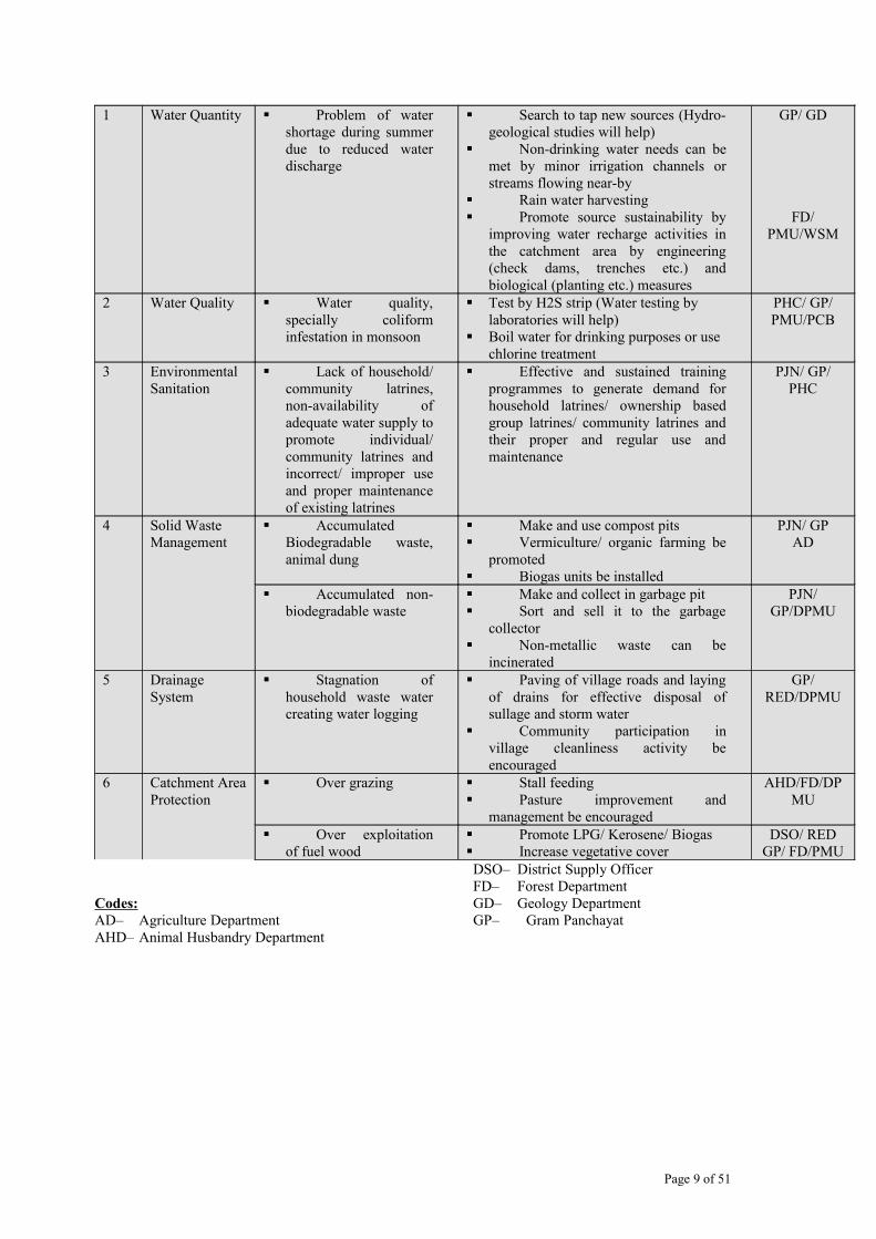
1 Water Quantity Problem of water shortage during summer due to reduced water discharge
Search to tap new sources (Hydro-geological studies will help)
Non-drinking water needs can be met by minor irrigation channels or streams flowing near-by
Rain water harvesting Promote source sustainability by
improving water recharge activities in the catchment area by engineering (check dams, trenches etc.) and biological (planting etc.) measures
GP/ GD
FD/ PMU/WSM
2 Water Quality Water quality, specially coliform infestation in monsoon
Test by H2S strip (Water testing by laboratories will help)
Boil water for drinking purposes or use chlorine treatment
PHC/ GP/ PMU/PCB
3 Environmental Sanitation
Lack of household/ community latrines, non-availability of adequate water supply to promote individual/ community latrines and incorrect/ improper use and proper maintenance of existing latrines
Effective and sustained training programmes to generate demand for household latrines/ ownership based group latrines/ community latrines and their proper and regular use and maintenance
PJN/ GP/ PHC
4 Solid Waste Management
Accumulated Biodegradable waste, animal dung
Make and use compost pits Vermiculture/ organic farming be
promoted Biogas units be installed
PJN/ GPAD
Accumulated non-biodegradable waste
Make and collect in garbage pit Sort and sell it to the garbage
collector Non-metallic waste can be
incinerated
PJN/ GP/DPMU
5 Drainage System
Stagnation of household waste water creating water logging
Paving of village roads and laying of drains for effective disposal of sullage and storm water
Community participation in village cleanliness activity be encouraged
GP/ RED/DPMU
6 Catchment Area Protection
Over grazing Stall feeding Pasture improvement and
management be encouraged
AHD/FD/DPMU
Over exploitation of fuel wood
Promote LPG/ Kerosene/ Biogas Increase vegetative cover
DSO/ REDGP/ FD/PMU
Codes:AD– Agriculture DepartmentAHD– Animal Husbandry Department
DSO– District Supply OfficerFD– Forest DepartmentGD– Geology DepartmentGP– Gram Panchayat
Page 9 of 51

PCB– Pollution Control BoardPHC – Public Health CentrePJN– Pey Jal NigamRED– Rural Engineering DepartmentWSM–Watershed Management DirectoratePMU – Project Management Unit

2.1 Water Quantity IssueThough the state receives surplus precipitation every year, yet there are few pockets which show signs of reduction in rainfall. For instance, in Doon Valley, the average decrease in monsoon rainfall has been 206 mm/year. Together with this, the mean rainfall in the period 1901-64 was 2109±343 mm (mean ± Stand. dev.), while it was 1778±416 mm. for the period 1965-89. Since over 85% of the rainfall occurs in nearly three monsoon months, accessing that water for drinking and irrigation purposes has been a major challenge for the state. The undulating terrain and geology of the area, does not support the long-term retention of water on hills.
Water crisis in Uttarakhand is viewed as a cumulative effect of various factors, causing environmental degradation. Reduced vegetation cover due to depleting forest areas, over-grazing by live-stock, erosion of top soil due to faulty/intensive agricultural practices and other developmental activities (such as road construction, mining, urbanization etc.) have resulted into gradual reduction of recharging capacity of the aquifers in the hills.
In nutshell, the main causes of depleting water sources are large-scale deforestation, forest fires, intensive grazing pressure, fuel wood pressure on catchments and fragmented land holdings. These factors severely affect catchment area treatment activities, which in turn, affect the sustainability of water sources for drinking water supply.
2.1.1 Large scale degradation of macro-micro catchmentThe state has an area of 53483 sq. km. This entire area, is the catchment of one or the other river. Out of this, 30.27% area has been classified as wasteland. Besides this, nearly 30.94% of the area, which is classified as forest area, is degraded and devoid of tree cover. The moisture retention capacity of these degraded areas, directly influence the recharging capacity of the local aquifers. Most of the drinking water supply sources are situated in these areas. The findings of the environment analysis study clearly suggest that silt load on rivers and run-off water along the catchments, has significantly made many water supply sources unstable and unsustainable. Catchment treatment has primarily been the responsibility of Forest, Agriculture and Watershed Management Departments. Clearly, the interventions from these line departments have not been adequate. In light of this, the state government has recently made catchment treatment a mandate of many line departments and is trying to revive these catchments through a collective effort (i) GO No: 677/29-2 (05Pey)/2005 dated April 16 th
2005 and (ii) GO No: 1023/29/-2 (05Pey)/2005, dated April 16 th 2005). The project intends to dovetail catchment treatment efforts in their expected sub-project/water-supply-scheme areas.
2.1.2 Uncontrolled and over grazing on catchmentsAbout 70%-80% of rural populations are marginal farmers having less than 1 Ha of agricultural land. Livestock is the second source of income for the rural households (HHs) followed by agriculture. Therefore, livestock is an integral part of the livelihood system in the state. At present, the state has 2.4 million cattle more than the fodder supply capacity of the forests in the State. According to the environment analysis study, each HH has an average of 4.19 livestock. The fodder requirements for the livestock are essentially collected from the catchments, which are already degraded due to various factors. Therefore, development of source protection (for water supply schemes) in any catchment has to address, the grazing pressure in terms of its optimal production capacity.
2.1.3 Fuelwood pressure on catchmentsApart from the grazing pressure, the villagers are heavily dependent on catchment for fuel wood supply. According to the environmental analysis study, the existing fuel wood requirement is nearly 48 times the state average annual reported production. While there is a large variation in fuel wood consumption
Page 11 of 51

(depending upon the altitude and seasons), the average fuel wood consumption in the state is about 3.6 metric tonnes/household/year. Increasing demand of wood for fuel and heating in rural areas has substantially reduced the regeneration capacity of the community/reserve forest areas. The remedial measures are not sufficient to check this quantum of degradation.
2.2 Water Quality IssuesIncreasing levels of water contamination due to anthropogenic activities is slowly becoming an area of concern. Open defecation, lack of means to dispose animal waste and garbage are major contaminating factors in the state. Available information suggests that only 16% rural HHs have access to proper sanitation facilities and less than 2.2% of rural HHs have garbage/compost pits. Frequent flash floods and storm water also carry residues posing environmental risks for water storage of the piped water supply schemes. According to the EA study, the cattle generate about 1600 kg dung/ village/day and most of the villagers do not have cattle shed. Therefore, livestock residues are generally carried by run-off water, polluting the downstream water sources.
The general trend of the water quality results from raw water obtained from different sources is within the BIS norms for drinking water. Overall water quality in the state of Uttarakhand, especially in rural areas, does not appear to be a major concern, except at places, where bacteriological contamination is found on the surface sources. Most of this bacteriological contamination is in monsoon periods. Shallow wells in plains, at places, have water quality problems.
At present, the State Pollution Control Board (SPCB) has two water testing laboratories at Haldwani and Dehradun. They have provision to test water samples on payment basis. However, there is no comprehensive water quality strategy existing in the state. Most of the water sample analysis is undertaken on a random sample basis. Besides SPCB, health department also undertakes water quality surveillance. Every year, the health department distributes chlorine tablets in the state to the local communities for disinfecting the drinking water. The same department has undertaken over 32 thousand Ortho-Toludine tests for water quality. Besides this, the Swajal Project-I encouraged local people to use H2S strip test for checking bacteriological contamination. As part of this, extensive training was imparted to UWSSCs and SOs on how to use H2S at the village level.
2.3 Program Specific Other Issues
The issues described in the previous sections are the ones that are associated with the sector as a whole requiring larger policy interventions and programs to address them at a state level. The proposed project is scattered in nature and comprises construction of smaller water supply schemes mostly of single village and multi village types (called sub projects). The project specific environmental issues are the ones originating from the implementation of the project activities, especially linked to construction and operation of the water supply and sanitation schemes. The adverse environmental impacts have been analyzed with respect to the different water supply and sanitation options that could be used under this project.
2.3.1 Possible impact on down stream ecosystem and settlementsOne of the direct adverse impacts of the individual water supply schemes is anticipated to be the impact on down stream ecosystem and downstream human settlements that depend upon the same water sources. The waste (both solid and liquid) discharge of uphill villages affect the down hill villages in different ways. The waste of uphill villages is drained out in the streams going to downhill villages. The waste also contaminates subsoil water going down hill. Therefore, the waste (solid and liquid) of uphill villages must be discharged/ managed
Page 12 of 51

properly so that they do not contaminate directly or indirectly water sources of down hill villages. While tapping the drinking water sources, care must be taken that up-hill villages are not tapping the source. It should have enough water to fulfill the water requirement of all the villages, especially in summers. The left over discharge after tapping by different source should be such that some water is still left in the stream especially in lean periods to maintain stream ecology.
2.3.2 Possible impact on ecological resourcesThe state of Uttarakhand is well known for its rich bio-diversity providing favorable niche for different habitats, flora and fauna. The ecological impacts of the project activities are anticipated to be of two types – (i) one arising from reduced discharge (due to tapping of water by the proposed water supply scheme) to support down stream, and (ii) the other one pertains to damaging of ecological resources such as the forests in the sub project area due to the construction activities envisaged in the water supply schemes.
2.3.3 Possible impacts on land-use and topographyAs stated above, the project will roughly consist of 5900 schemes in various villages. A preliminary review of the sub-project area suggests that the distances between the source and the tail end distribution network will be minimal (may be less than one kilometer). Laying the trunk line will involve excavating a trench of at least 0.5 m width for a distance of one kilometer of alignment. These earthwork activities will not have any significant impact on the topography of the area. The UWSSC will ensure that the earthwork activities are completed as soon as possible. The DPMU will coordinate with the SOs for monitoring the work and ensuring that the earthwork activities are undertaken either before the rainy season or after it.
The impact on soil due to the project will be in terms of localized topsoil erosion along the alignment, and due to construction activities, which will be insignificant. Since the alignment may pass through some agricultural lands (in some cases), topsoil loss will have an impact on future agricultural yield. Given the small size of the sub- project, the yield loss may not be significant. However, the UWSSC may face some local resistance on this issue. The ES of DPMU and local SO will need to coordinate to resolve the issues in presence of GP members.
2.4 Possible impact due to inadequate environmental sanitation The proposed alignment of the main trunk line is expected along the existing roads and does not encroach or pollute any surface water bodies in the rural areas. However, bacteriological contamination may pose a threat to the sub-project. Each gravity-based sub-project/scheme will have one source collection point, RF/slow sand filter and a storage tank from which the individual household connection and common stand-post will receive water supply. According to the government reports only 16% of rural households (HHs) have access to toilet facilities. Open defecation has been a common practice in the rural areas. Considering that most rural areas in Uttarakhand are not having any sewerage systems, the run off water (during raining season) carries most of the solid and liquid residues along the slope posing water quality risks for the main-storage and source collection tanks under this gravity based water supply schemes/sub-projects. Therefore, sub-projects need to undertake adequate measures ensuring that no-solid and liquid wastes are allowed to affect the above three structures in terms of seepage or any form of intrusion. Regular advocacy and communication strategy has been developed under the project for ensuring proper fencing of these three structures to ensure both safety and quality. For details, the Operational Manual can be referred.
Page 13 of 51

According to the Government report, only 2.2% of the rural HHs have garbage and compost pits. Hence collection and disposal of the solid and liquid waste will be a critical factor to avoid pollution of main storage water in the sub-project areas. The UWSSC (User Water and Sanitation Sub-Committee) in consultation with the GP and SO will develop a local-specific plan to avoid the entry of such sewage water into the storage tank. The ES will facilitate the entire process and provide any catalytic support.
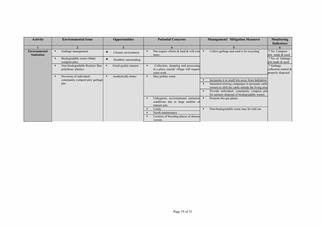
3.0 Environmental Management Measures The management measures for the various environmental issues that are discussed, fall into two distinct categories – the ones that require larger policy and program interventions as their scope is much wider compared to the proposed program, and the ones that can be reasonably addressed through this program. This section attempts to describe the management measures for the latter category, though relevant reference has been made to the larger interventions that are required for the sector-wide approach. The following Table 1 gives the brief of the Environmental issues, related opportunities, concerns, management/ mitigation measures and monitoring indicators.
Page 14 of 51

Table 1
Tables 1: showing Environmental issues, related opportunities, concerns, management/ mitigation measures and monitoring indicators
Activity Environmental Issue
Opportunities Potential Concerns Mitigation/ Mitigation Measures Monitoring Indicators
1 2 3 4 5 6
Water Supply
Water Quantity
Waste water tapped Depletion in ground/surface water level
Augment supply though rehabilitation/ upgrading of existing system wherever feasible
* W/S schemesConstructed & managed by GP
Free running water may be eroding areas and creating swamps and becoming breeding ground of vectors
Risk of hydraulic interference in aquifers
Identify new sources (local/distant) of good quality and yield
* Schemes with CAC&MP
Availability of increased/ demanded level of safe drinking water on a sustainable basis
Local hydrology disturbed Protect the source by fencing
* RWH Unit commissioned
Labour, time and cost saving in fetching water Increased ground/ surface water abstraction
Dual water supply *No. of UWSSC managing W/S
Improvement in quality of ground water through dilution due to recharge
Disturb the stream ecology, its flora & fauna
Blending of water from existing sources *NC/PC habitation covered
Animals may also get easy access to water for drinking
Traditional practices may be changed
Catchment treatment *Tribal habitation covered
Catchment area treatment has positive spin-offs Lesser water for downstream villages
Spring protection * Catchment area covered by Project
Will improve water quantity and quality Downstream cropping pattern may have to be changed
Spring sanctuary (Source catchment protection) * Catchment area covered by others
Reduction in water and sanitation related diseases, improved personal/ family health and hygiene leading to improved quality of life of the people
More polluted water for down stream villages
Sub soil water recharge * periodic source discharge measurement
Women labour saved from the water fetching work
Water stagnation at spill over areas
Managed grazing * Source disputes resolved
Women getting more time to undertake some income generating activities and home management
Financial burden on the community and the GP
Planting by perennial crops (Silvi-pasture) * Use of source for other use
Increase in value of property Increased generation of sullage Augment water availability by Rainwater harvesting
* Land status of the source point
Possibility Malaria/ Filaria etc. diseases if water stagnates
Proper designing of water use/ drawl system/ drainage system wll help
* CACMP trainings imparted
Page 15 of 51
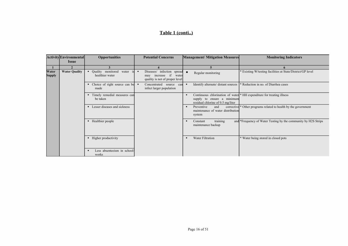
Table 1 (conti..)
Page 16 of 51
Activity Environmental Issue
Opportunities Potential Concerns Management/ Mitigation Measures Monitoring Indicators
1 2 3 4 5 6Water Supply
Water Quality Quality monitored water is healthier water
Diseases/ infection spread may increase if water quality is not of proper level
Regular monitoring * Existing W/testing facilities at State/District/GP level
Choice of right source can be made
Concentrated source can infect larger population
Identify alternate/ distant sources * Reduction in no. of Diarrhea cases
Timely remedial measures can be taken
Continuous chlorination of water supply to ensure a minimum residual chlorine of 0.5 mg/liter
* HH expenditure for treating illness
Lesser diseases and sickness Preventive and corrective maintenance of water distribution system
* Other programs related to health by the government
Healthier people Constant training and maintenance backup
*Frequency of Water Testing by the community by H2S Strips
Higher productivity Water Filtration * Water being stored in closed pots
Less absenteeism in school/ works

Table 1 (conti..)
Page 17 of 51
Activity Environmental Issue
Opportunities Potential Concerns Management/ Mitigation Measures Monitoring Indicators
1 2 3 4 5 6
Environmental Sanitation
Construction of household/ group/ community/ institutional latrines
Hygienic Risk of down slope village water contamination
Sustained training programmes with focus on women to generate demand for household/group/ community latrines
* No of toilets constructed & used
Convenient- women need not go far
Lack of space for household latrine Install ‘safe’ sanitation systems to suit local soil type.
* Types of toiletsconstructed
Reduction in soil and surface water contamination
Keeping clean can be problem Proper placing of toilets be done * No. of garbage pits constructed
Reduction in water and sanitation related diseases, improved personal/ family health and hygiene
Can breed disease if not well-kept Construct sullage drains and provide low cost treatment/ disposal/ re-use system for sullage
* No. of compost pits constructed
Improved Social status Risk of ground water contamination from sanitation systems where the ground water table is high or due to rocky bottom (Shallow soil depth)
Safe disposal of waste grey and black water
*Rural sanitary marts established
Dignity, safety and convenience of household
Concentration of sewage disposal * No. of Village clean up campaigns
Inculcating desirable healthy practices amongst children who can serve as catalyst to promote household hygiene
More water will be required specially for wet toilets
* No. of soak pits constructed
Improvement in general health status of people
Safe disposal of water can be problem if whole village has not got proper drains
* No. of Schools & Anganwari covered by sanitation facilities
Enhanced environmental sanitation and hygiene status and general aesthetics of village
* Existing drainage system & provided
Sanitary disposal of sullage
Improved aesthetics and reduction in breeding places for mosquitoes
Increase in property value

Table 1 (conti..)
Table 1 (conti..)
Page 18 of 51
Activity Environmental Issue Opportunities Potential Concerns Management/ Mitigation Measures Monitoring Indicators
1 2 3 4 5 6Environmental
SanitationSafe disposal of water Less erosion High erosion can cause slips and land
slides Safe water disposal by construction of low
gradient channels
*Drainage system
Less land loss Can damage agriculture fields Water be left out only in existing natural “gaderas” Extend drains up to natural Gadera
Safe Even can damage houses etc. Side drain be made in steps on steep gradient
Healthier Unmanaged fast running water can form gullies
Make stilling tanks after some distances
Can contaminate agricultural crops and fields if not properly led out of village.
Try to make stilling tanks/ check dams to let sludge to settle down
Construction of storm drainage
Better hygienic conditions Can be source of soil erosion Design and install efficient storm water drains at proper gradient
* Existing Drainage System & provided
Healthy people Can breed vectors if not made or maintained properly
* Quality of internal roads
Paving of internal paths in villages
Excess water is safely drained out
Side drains if not properly made and maintained can become gullies
Change alignment, rough surface preferred and cross barriers on steeper stretches
Walking, specially at night for women and children be safe
On steep slopes, paths may become slippery, especially for animals – at higher risk of bone injury.
Wide steps on steep portions
Hygienic and clean environment
Paving of internal paths with appropriate locally available material/ water bound macadam/brick to ensure proper drainage.
Less eroding and damaging to areas below paths
*Provide cross-drainage at appropriate places
Activity Environmental Issue Opportunities Potential Concerns Management/ Mitigation Measures Monitoring Indicators
1 2 3 4 5 6Environmental
Sanitation Garbage management Cleaner environment Pits require efforts & land & will cost
more Collect garbage and send it for recycling * No. Compost
pits made & used Biodegradable waste (Make
compost pits) Healthier surrounding * No. of Garbage
pits made & used Non-biodegradable Restrict/ Ban
polythene/ plastics Good quality manure Collection, dumping and processing
at a place outside village will require extra work
* Garbage collection started & properly disposed Provision of individual/
community compost pits/ garbage pits
Aesthetically better May pollute water Incinerate it in small lots away from habitation Sustained training campaigns to persuade cattle
owners to shift the cattle outside the living area Provide individual/ community compost pits
for sanitary disposal of biodegradable wastes Unhygienic environmental sanitation
conditions due to large number of manure pits
Promote bio-gas plants
Costly Non-biodegradable waste may be sold out Needs maintenance Creation of breeding places of disease
vectors
Page 19 of 51

Together with this, the details of relevant Environmental Codes of Practices (ECOPs) for following activities are stated in Annex. I1. Identification of Sources of Water Supply2. Protecting Surface Water Supply Source and Ensuring Sustainability3. Protecting Ground Water Supply Sources and in Ensuring Sustainability4. Water Quality Monitoring5. Selection of Safe Sanitation Technology Options (Including Drainage) at Individual
Household and Community Level6. Selection of Location for Community Toilets7. Safe Sullage Disposal and Organic Waste Management8. Safe Solid Waste Management at Individual Household and Community Level
3.1 Management Measures for Source Protection and its SustainabilitySource protection and its sustainability have been identified as a priority area of intervention under the environment component of the proposed project. Various interventions have already been demonstrated in Swajal project’s micro-catchment treatment options for source protection and recharge of the local aquifer. The PMU intends to upscale similar type of interventions under the proposed project. The sources include perennial spring water, stream water and uncontaminated shallow and deep aquifers that can be tapped for single/ multi village based piped water supply schemes.
According to the environmental analysis study, every village in Uttarakhand hills has few perennial water sources in the form of natural springs. Therefore, most sub-projects are likely to tap only spring water as the key water supply source for the single/ multi village schemes. Given the fact that 75% of rural population in the state depends on spring water sources for drinking and cooking, the project needs to develop systematic/controlled spring water management norms within the community – so that the very purpose of this source protection is not defeated. A detailed plan for forest land transfer Annexure II and mitigation plan along with cost estimation is stated in the Annexure-III. However, the following steps are some of the key steps required for planning and execution for source protection and its sustainability:-
Step-1: The source centered Catchment Area Plan is to be implemented in phases involving identification and assessment of source catchment, creating a baseline database for the source catchment, delineation of zones for treatment within the source catchment and prioritization of issues and interventions. The planning and execution will involve three stages of interventions; 1) technical intervention plan, 2) cost estimation plan, 3) and a monitoring plan. While the SO, GP and other resource agency will provide technical support for developing and finalizing these plans, the management and implementation remains the responsibility of the UWSSC.
Step-2: A Planning phase agreement will be signed between Support Organization/GP, DPMU and UWSSC. The agreement will clearly define the description of activities to be performed during the planning phase. The agreement will have provisions for source catchment assessment, problem identification, catchment area identification and zonation. The provision for the manpower and cost required for the various activities to be performed will also be part of the planning phase agreement. The outcome of the planning phase will be the Detailed Environmental Project Report (DEPR). The Plan Formulation and Source Centered Catchment Area Conservation and Management Programme will be depicted in the DEPR.
Step-3: The ES of the DPMU will ensure that the UWSSCs and SOs selected for implementing the sub-project activities follow the guidelines developed under the environmental mitigation plan. It will also ensure that the source protection work start before the onset of monsoon. As part of the implementation process, the UWSSC in
Page 20 of 51
coordination with the local SO will need to submit a technical and a financial report (stating key activities expected to be undertaken by UWSSC for source catchment treatment). The technical report should include all environmental concerns: availability of water sources, measures for source protection, technical support required from GP and DPMU, type of support required from the line departments during the construction and operation of the catchment treatment plan for source protection, water quality monitoring strategy and emergency (contingency) plan for any environmental crisis during the operation. This activity can also be clubbed with water supply scheme plan.
Step-4: Based on the technical report, the ES at the DPMU will undertake a quick appraisal of the proposed environmental management plan (EMP) validating the technical report. Based on ES report, the DPMU will directly release the budget to the UWSC for implementing the EMP. The DEPR will be implemented through provisions of the Implementation Phase Quadrapule Agreement (IPQA), signed between the DPMU, SO and the UWSSC. The DEPR will be the integral part of the IPQA. The outcome of the IPQA will be the successful implementation of the DEPR.
Step-5 : An external independent service agency will be placed to supervise the progress of the implementation. The Agency will be required to monitor the monthly progress and provide technical support and guidance to the GP/UWSSC. The agency will be also responsible for the quality of the work under implementation.
3.1.1 Management of Large scale degradation in mini-catchment areasIn view of the large-scale degradation of the catchment, the project has made a conscious attempt to ensure that each sub-project is adequately supported by a small micro-mini-catchment treatment plan. This includes contour/terrace-bunding, creation of percolation tanks, plantation/grass land development on village forest and reserve forestland including percolation/recharge pits and drainage treatments. While the catchment area for recharging any spring/stream sources would require a larger intervention in a micro-catchment, the project intervention would focus on a limited scale (focus on micro-mini-catchment) and the remaining watershed interventions would be dovetailed with other line department activities. Catchment treatment to be carried out at the sub project level is expected to include treatment of an average of 5 Ha of forest/community/private land around the source as part of the source protection measures (detailed cost and technical specifications for different catchment treatment interventions are provided at Annex-2). However, for long-term sustainability of the schemes located in critical watershed areas, the PMU shall coordinate with the Forest Department & Watershed Management Department of GoUA to implement larger interventions in these areas. Key management steps required to treat a mini-catchment of the source, include the following, for which ECOPs for Identification of Sources of Water Supply; Protecting Surface Water Supply Source and Ensuring Sustainability; and Protecting Ground Water Supply Sources and in Ensuring Sustainability may be referred. (Refer ECOPs Annexure I)
1. Protecting the catchment area from grazing animals.2. Rotational Grass cutting (for fodder) may be permitted in line of rangeland
management as appropriate in the catchments.3. Check-daming and gully plugging would be done in gully formations of micro-
mini-catchments.4. Staggered contour trenches with grasses would be made around source for its
protection.5. Locally suitable plants and useful brushwood (as Rhus, Carissa, Debregeasia etc.)
would be planted in each trench.6. Plantation of multipurpose trees (1000 trees/ ha.) will be encouraged - mainly
locally suitable broad leaved species as Oak, Horse chestnut, walnut, mulberry etc.
Page 21 of 51

3.1.2 Management of Uncontrolled and over grazing in catchmentsAnother perceived environmental risk for source protection includes, the grazing and fuel wood extraction pressure on the source catchment. Considering that the livestock has been an integral part of the existing livelihood system, the sub-project will encourage stall-feeding practices and reduce grazing pressure on the catchment areas through various community mobilization interventions.
Over grazing can be controlled by encouraging people to keep few high-yielding variety of cattle. Proper grazing management activities would be encouraged in line of close and open rangeland management practices. Besides this, the carrying capacity of grazing land can also be improved by promoting plantation of good quality of grasses, legumes of higher fodder value and making staggered contour trenches to improve the moisture regime. This would also include encouraging people to use crop residue as fodder through a collective effort at the village level. The project plans to have extensive community mobilization action by using support agencies for creating such awareness activities.
3.1.3 Management for Fuel wood pressure A preliminary assessment suggests that fuelwood is primarily collected from the catchments that are having rich biomass base and are also having the sources for water supply schemes. In light of this, the project has made provision for creating awareness for alternative energy campaign (promoting LPG) for cooking and stall-feeding for livestock. While the program does not intend to undertake any capital intensive hardware intervention, software intervention in the form of campaign advocacy for reducing fuel wood pressure includes the following steps.
1. Promotional camps for LPG in coordination with private companies would be undertaken in each sub-project areas.
2. Encouraging/promoting biogas plants in sub-project areas.3. The project would be promoting wood saving devices (Priyagni Angethi, Smokeless
Chullah) and alternate source of energy (solar) in collaboration with other line departments.
3.2 Management of Water Quality IssuesInformation available with different line departments dealing with water sector development suggests that heavy metal and chemical contamination may not pose any risk to the project. However, bacteriological contamination may pose some concern for the project. Keeping this in mind the project has developed specification for treating the water in each sub-project area. The proposed treatment involves three-fold interventions; i) undertaking regular residue chlorine testing (residue assessment) by the UWSSC, ii) testing of water samples from different single/multiple village schemes (particularly from source collection point and storage tank) periodically (twice in a year) for bacteriological parameters by using locally available techniques, iii) testing of water sample (random basis) for any possible heavy metal and chemical contamination once in two years. The bacteriological test will be undertaken to assess the coliform and fecal coliform count in the common storage tank from which the water is taken for households and common stand-post supply. Detailed water quality monitoring will be done at the time of selecting a site for tapping water sources. Critical water quality parameters identified would be kept in mind for future follow-up actions. Water testing will be done twice every year at the end of July and February (pre-post monsoon), especially for bacteriological contamination. Provisions are also made for emergency water sample testing in case of any eventuality such as epidemic in the sub-project area or in vicinity. The table 2, below gives the type of tests, facilities available, frequency of tests, and organizations responsible for execution and monitoring of the water quality-testing program.
Page 22 of 51

Table 2
Water Quality Testing Process
Page 23 of 51
Types of Test Laboratory Facilities/Means of surveillance
Responsibilities at the Village level
Frequency of Testing
Cross-verification Overall Responsibility/Monitoring
1 2 3 4 5 6Turbidity, Colour, Taste, Odour, pH, TDS, Hardness
Field test Kit and State Pollution Control Board (SPCB) laboratories at Haldwani or Delhradun
SO will help UWSSC collecting water sample and get it analyzed in coordination with ES of DPMU. Regular sample collection procedures will be mainstreamed by the PMU
Quarterly Public health department (PHD) regularly undertakes random sample analysis. PMU will coordinate with PHD ensuring sensitive sub-project areas samples are analyzed. Only 2% of the sample will be cross-checked.
- As part of the SWAP, the PMU will coordinate with line departments (PHD, SPCB, Jal Nigam and Forest department)- PMU in coordination with DPMUs will organize training for all SOs and Selected UWSSC members. The training will include sample collection procedure and safety measure that needs to adopted.
Nitrate, Chloride, Sulphate, Fluoride, Iron
SPCB laboratories. Only 10% of the random sample will be sent for testing by using AAS
SO Once a year 2% of the sample needs to be cross-checked by DPMU with help PHD and SPCB
ES of DPMU. GP/SO will help ES in compiling and creating a database
Bacteriological, MPN
By using H2S strips SO and UWSSC Twice a year Pre and Post- monsoon
By DPMU taking few random sample with the help of SPCB
PMU will ensure that master trainers are regularly sent to train SOs and UWSSC during first two years of the project. PMU will ensure that H2S strips are procured and provided to all UWSSC and SO
Heavy metal residues This can be done by using AAS available in SPCB laboratories. Only 10% of the random sample should be sent for testing
PMU will make special arrangements with SPCB(without any additional burden on SPCB) for sample collection analysis
Once in year NA PMU with the help of SPCB will be responsible for this task
The monitoring of physio-chemical and bacteriological parameters under this project include; turbidity, colour, taste, odour, pH, total dissolved solids, total hardness, chlorides, calcium, nitrates, iron, flourides, sulphates and bacteriological parameters such as MPN Coliform bacteria per 100 ml & E coli per 100 ml. The project will adhere to the permissible limit/standard prescribed by the Indian National Standard. Institutional arrangement has been made by PMU for testing of water samples in local laboratories, which can be conveniently accessed from different sub-project areas. Since testing of Coliform should be done within a short period, H2S strip will also be encouraged by the project. Accordingly, UWSSC will be trained for regular testing by using H2S with the help of the support organization. The key management measures required as part of the water quality surveillance include the following:
1. Undertaking chemical and bacteriological water testing of the source, prior to any execution work of the water supply scheme.
2. Undertaking regular bacteriological test during the implementation phase for assessing coliform infections. This would be done by the UWSSC/GP/SO, using H2S strips, preferably during pre-post-monsoon times.
3. The training of UWSSC along with SOs on the use of H2S for bacteriological testing of water samples at village level. Each UWSSC will be provided with H2S strips by the DPMU. The SO will provide all catalytic support for undertaking regular (quarterly) water quality surveillance and mitigation measures in consultation with GP. The PMU in coordination with DPMU will make regular training arrangements for the UWSSC, SOs and Selected GP members on how to undertake bacteriological testing by using H2S.
4. In case of any coliform presence, the project will coordinate with the health department and supply chlorine tablets for disinfecting the storage tanks. Besides this, regular checking of chlorine residues in the storage tanks, would also be an integral part of the project.
5. Project would establish a mechanism in coordination with the Pollution Control Board to allow user UWSSC/GP, to use its laboratories for water sample testing on demand basis.
6. The State does not have any water testing laboratory facilities at the district level. Having
adopted sector wide approach (SWAP), the project must ensure that the concerned line departments (Health, Pollution Control Board and Pey Jal Nigam) develop decentralized water testing facilities so that the UWSSC can access such facilities at the district level. At present, the state has only two laboratories with Spectrophotometer and Atomic Absorption Spectrophotometer (AAS) facilities managed by the Pollution Control Board.
7. While the project does not anticipate any industrial effluent discharge in the districts that can pose any concern for the chemical and heavy metal contamination in downstream areas, it has taken adequate precaution for any such possible contamination. Most of the districts in Uttarakhand state fall into hilly terrain of Himalayan region (High/Mid-himalayan and Shivalik Hilly regions). However, there are two districts (Haridwar and Udhamsingh Nagar) in the state that fall into the plain Tarai-belt of India. These two districts are subject to intensive agricultural practices with increasing use of pesticides and fertilizers. According to the PMU, most of the single/multiple village water supply schemes in these two districts are likely to tap groundwater as the main source for water supply. Considering the increasing trend of using pesticides and fertilizers in these two districts, the project has made provision of regular tubewell water testing for chemical as well as bacteriological contamination.
Page 24 of 51

3.3 Management of Project specific other issues
3.3.1 Possible impact on down stream ecosystem and settlementsAvailable information suggests that 62.5% of the state land belongs to forest department. Since most of the spring water sources are located in forest areas, the project has made provisions for diversion of forest land required for creating source storage tank in line with the state government’s order and Ministry of Environment & Forest (MoEF), Government of India’s guideline. This includes the net-present value cost of the forest land. A detailed estimation of the compensation required to be paid in lieu of the forest land likely to be used for source collection, storage and distribution network of water supply scheme is indicated in Annex-II.
3.3.2 Possible impact on ecological resourcesThe forest department has well laid procedures to minimize the impacts on the forestland and has adequate controls in place, requiring the implementing agencies obtain necessary approvals before initiating any construction in the forest areas. In this context as well as in light of the scale of activities envisaged in water supply schemes, impact on ecology in terms of cutting of trees and/or damaging the forestland is not expected to be significant
Each single/multiple village based scheme will require a small (2 feet / 3 feet) water storage space (mainly in the forest land). Keeping this in mind, the State Government and the MoEF have stipulated specific norms for such water supply projects in hill states (Annex-II). The project will comply with these MoEF norms. While laying down pipeline from source to the tank, through forests, care should be taken not to fell any tree. After laying the underground pipelines, the soil should be compacted with adequate plantations. The project will also ensure that small cross-bunds (stone pitching) are made on excavated/compacted areas to prevent water runoff over it and any further soil degradation.
3.3.3 Possible Impacts on land-use and topographyIn general there will be no long-term appreciable impact on the land use and topography. There may be some disturbances at the time of water supply construction. Hence, the project will only develop its distribution network of piped-lines either pre-harvesting or post harvesting period to avoid any damage to the standing crop.
3.3.4 Possible impact due to inadequate environmental sanitation According to GoUA, only 16% rural households have access to proper sanitation facilities and less than 2.2% of HHs has garbage or compost pits. Considering that majority of the project areas fall into hilly terrain, run off of frequent flash floods and storm water may carry residues posing environmental risks for water storage of the piped water supply schemes. The project has made provision for garbage pits, soak pits, compost pits and for improved drainage system in sub-project areas.
For non-biodegradable waste the project will adopt extensive community mobilization strategy to segregate these wastes at primary level (glass, metal, plastic, paper etc.). As part of the SWAP, the project will also coordinate with specialized agencies to help in safe disposal or recycling these wastes. The project’s community mobilization strategy will promote basic primary segregation at the village/household level; of waste having economic value, waste having hazardous implications and waste that can be disposed at the village level
Page 25 of 51
with collective input from the community itself. The waste having economic value will be collected at one place near village and it will be disposed with the help of a professional garbage collector. The biodegradable waste will be collected in garbage pits in the form of landfills and subsequently used as compost. Care should be taken to select site from which there is no leaching to any drinking water source. The project will also encourage for soak pits at the household and community level for improved environmental sanitation practices through advocacy and campaign. The detailed design and methodology given in the Operational Manual may be referred.
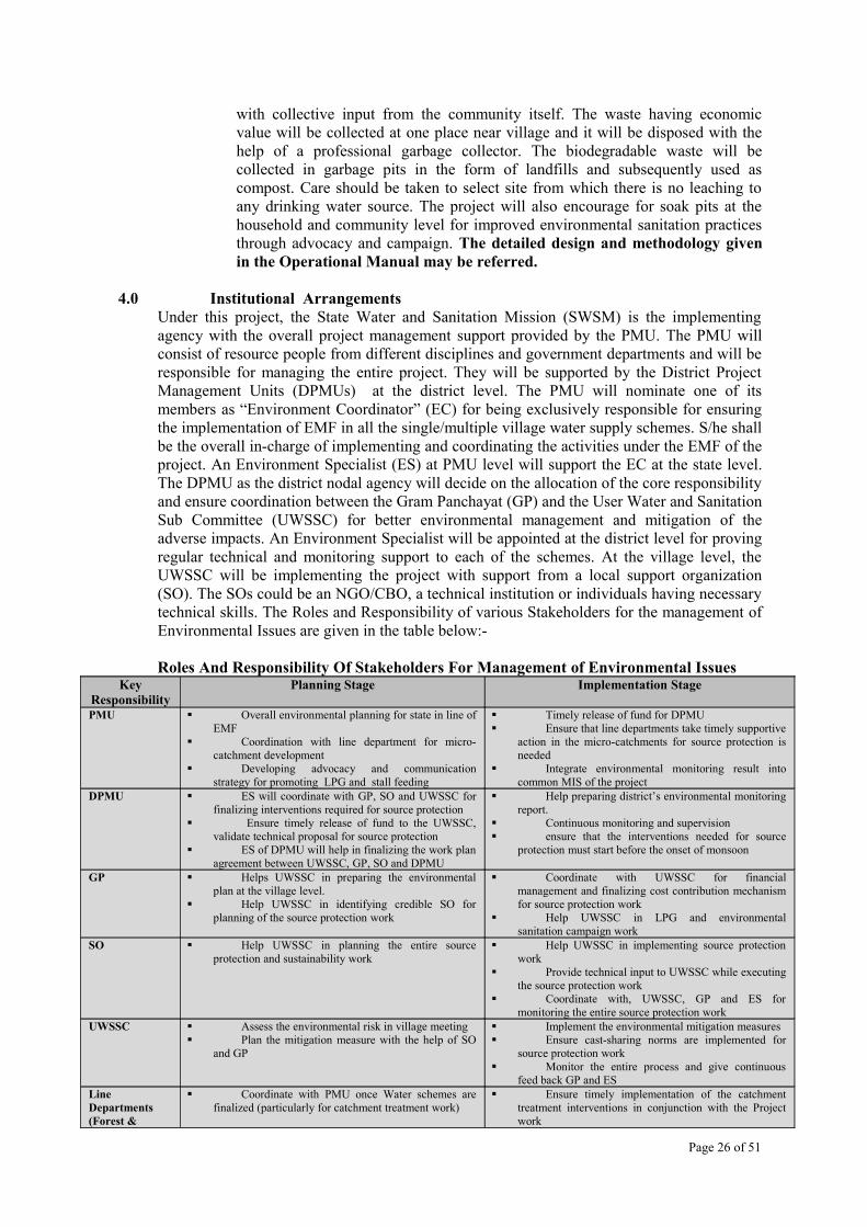
4.0 Institutional ArrangementsUnder this project, the State Water and Sanitation Mission (SWSM) is the implementing agency with the overall project management support provided by the PMU. The PMU will consist of resource people from different disciplines and government departments and will be responsible for managing the entire project. They will be supported by the District Project Management Units (DPMUs) at the district level. The PMU will nominate one of its members as “Environment Coordinator” (EC) for being exclusively responsible for ensuring the implementation of EMF in all the single/multiple village water supply schemes. S/he shall be the overall in-charge of implementing and coordinating the activities under the EMF of the project. An Environment Specialist (ES) at PMU level will support the EC at the state level. The DPMU as the district nodal agency will decide on the allocation of the core responsibility and ensure coordination between the Gram Panchayat (GP) and the User Water and Sanitation Sub Committee (UWSSC) for better environmental management and mitigation of the adverse impacts. An Environment Specialist will be appointed at the district level for proving regular technical and monitoring support to each of the schemes. At the village level, the UWSSC will be implementing the project with support from a local support organization (SO). The SOs could be an NGO/CBO, a technical institution or individuals having necessary technical skills. The Roles and Responsibility of various Stakeholders for the management of Environmental Issues are given in the table below:-
Roles And Responsibility Of Stakeholders For Management of Environmental IssuesKey
ResponsibilityPlanning Stage Implementation Stage
PMU Overall environmental planning for state in line of EMF
Coordination with line department for micro-catchment development
Developing advocacy and communication strategy for promoting LPG and stall feeding
Timely release of fund for DPMU Ensure that line departments take timely supportive
action in the micro-catchments for source protection is needed
Integrate environmental monitoring result into common MIS of the project
DPMU ES will coordinate with GP, SO and UWSSC for finalizing interventions required for source protection
Ensure timely release of fund to the UWSSC, validate technical proposal for source protection
ES of DPMU will help in finalizing the work plan agreement between UWSSC, GP, SO and DPMU
Help preparing district’s environmental monitoring report.
Continuous monitoring and supervision ensure that the interventions needed for source
protection must start before the onset of monsoon
GP Helps UWSSC in preparing the environmental plan at the village level.
Help UWSSC in identifying credible SO for planning of the source protection work
Coordinate with UWSSC for financial management and finalizing cost contribution mechanism for source protection work
Help UWSSC in LPG and environmental sanitation campaign work
SO Help UWSSC in planning the entire source protection and sustainability work
Help UWSSC in implementing source protection work
Provide technical input to UWSSC while executing the source protection work
Coordinate with, UWSSC, GP and ES for monitoring the entire source protection work
UWSSC Assess the environmental risk in village meeting Plan the mitigation measure with the help of SO
and GP
Implement the environmental mitigation measures Ensure cast-sharing norms are implemented for
source protection work Monitor the entire process and give continuous
feed back GP and ESLine Departments(Forest &
Coordinate with PMU once Water schemes are finalized (particularly for catchment treatment work)
Ensure timely implementation of the catchment treatment interventions in conjunction with the Project work
Page 26 of 51

Watershed)
4.1 Management Plan for Source Centered Catchment Area Conservation and Management Program
The Roles and Responsibility of various stakeholders like UWSSC, GP, SA, SO & DWSM for the management of Catchment Area Protection Activities is as per the flow-chart.
4.3 ENVIRONMENTAL MANAGEMENT PLAN
For effective implementation of the projThe support structure for major environmentbelow: -
RECOMMENDED ENVIRONMENTAL MANAGEMENT PLAN (EMP)Codes:AD– Agriculture DepartmentAHD–Animal Husbandry DepartmentDSO– District Supply Officer
FD– Forest DepartmentGD– Geology DepartmentGP– Gram Panchayat
Page 27 of 51
Stages
A- CATCHMENT ASSESSMENT1. Physical Assessment*Land surface, Water resource2. Geo Hydrology3. Biological Assessment4. Socio-economical(SA/SO/GP/UWSSC & ES of DPMU)B- PROBLEM IDENTIFICATIONCatchment Area ( SA/GP/UWSSC)Village Area (UWSSC & ES DPMU)C- CATCHMENT AREA ZONATION- Delineation of treatment area(SA/SO/GP/UWSSC with ES)
D- PLAN FORMULATION ( By UWSSC)- Interventions & cost assessment
E- IMPLEMENTATION OF PLANCatchment level (UWSSC/GP)Village level (UWSSC & SO)
I
II
III
S
ou rce
Cen
tere d
Cat
ch
me
nt
Are a
Con
serv
atio n
and
Man
age
men t
Pro gra
m
WORK & RESPONSIBILITY
F- MONITORING by SA & ES of DPMUs
G- MODIFICATION (by SA & ES)
IV
V
VII
VI

PCB– Pollution Control BoardPHC –Public Health CentrePJN– Pey Jal NigamRED– Rural Engineering DepartmentWSM– Watershed Management DirectoratPMU – Project Management Uni
Page 28 of 51
VI

4.2 Monitoring and Performance Tracking of Source Centered Catchment Area Conservation and Management Program
In order to evaluate the efficiency of mitigation measures the monitoring will focus on the two types of observations in the sub-project areas; 1) visual observation of overall environmental conditions and, 2) monitoring specific environmental quantitative/qualitative parameters. Project design is purposefully flexible to encourage a variety of approaches. It was agreed that the project design will need to allow for rapid learning and replication. At the same time, it is important to learn as systematically as possible from these interventions. The M&E component would be designed accordingly. The M&E system will permit to learn from the variety of approaches adopted during proposed project so that the lessons learned can subsequently be fed back into the project. The objective of the monitoring programme is to assess the efficiency of mitigation and
enhancement measures suggested in the EMF and adoption of additional mitigation measures if necessary, for improving the environmental conditions in the project area, particularly, for improving source sustainability. Source centered catchment area conservation and management plan requires a balanced approach with integration of various biological, engineering and social components in the three tiers Panchayati Raj system. The catchment area also involves active participation of different stakeholders in planning, execution, supervision and monitoring. The proposed monitoring flow chart (below with indicators) is developed with the objective of effective monitoring and evaluation at different stages of program by involving the state level, district level and GP level organizations, which will be supported by service agencies and SOs. The monitoring plan will facilitate phase wise monitoring of activities by different agencies involved in plan execution.
MONITORING PLAN
4.3 Fund flow arrangements for the implementing/mitigating source centered catchment
Page 29 of 51
Guidance supportSupervision
- Monitoring & Evaluation
Agency / Member Work Responsibility
SWSM (Environmental
Coordinator/E.S)
State Level
Gram Panchayat & concerned UWSSC
UWSSC (6 or 7 members selected by community involving Village
pradhan/ Van Panchayat surpanch/GP/ women & weaker
section)
Organization level
Input from community, awareness,
management Execution,
Maintenance
Overall coordination & planning/management
Overall Guidance supportState level information support /Monitoring & Evaluation
GP/HabitationVillage Level
(UWSSC)
DPMU( PM/ES)District Level
SA
SO
Geohydrology /Forestry/ SWC/
/Engineering expertSocial Expert
Forestry/ Engg. expert
Social aspectTrainers
Environmental Monitoring Indicators1. Source Discharge (lpm). 2. Natural Regeneration in the area (No/ha).3. Plant survival rate/regeneration in percentage. 4. Households adopting stall feeding practices.5. Number of Households using LPG/other sources for cooking & heating.
SWSM: State Water and Sanitation Mission PMU: Project Management UnitDWSM: District Water and Sanitation MissionDPMU: District Project Management UnitUWSSC: User Water and Sanitation Sub Committee
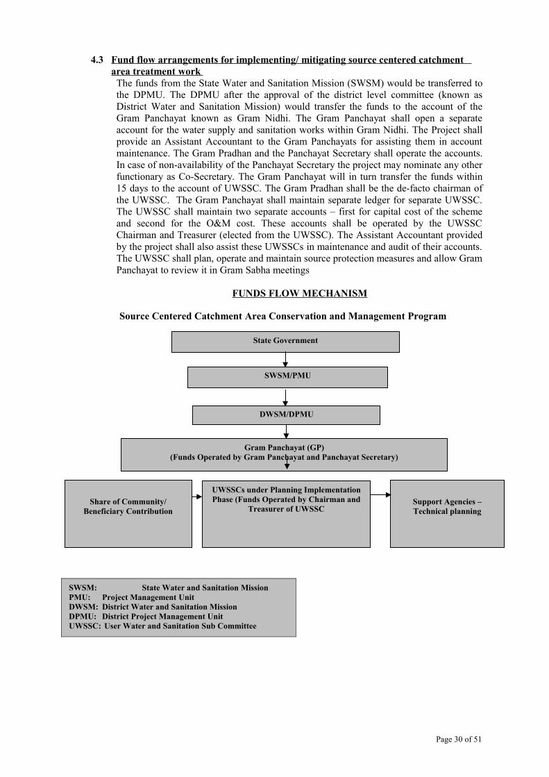
4.3 Fund flow arrangements for implementing/ mitigating source centered catchment area treatment work
The funds from the State Water and Sanitation Mission (SWSM) would be transferred to the DPMU. The DPMU after the approval of the district level committee (known as District Water and Sanitation Mission) would transfer the funds to the account of the Gram Panchayat known as Gram Nidhi. The Gram Panchayat shall open a separate account for the water supply and sanitation works within Gram Nidhi. The Project shall provide an Assistant Accountant to the Gram Panchayats for assisting them in account maintenance. The Gram Pradhan and the Panchayat Secretary shall operate the accounts. In case of non-availability of the Panchayat Secretary the project may nominate any other functionary as Co-Secretary. The Gram Panchayat will in turn transfer the funds within 15 days to the account of UWSSC. The Gram Pradhan shall be the de-facto chairman of the UWSSC. The Gram Panchayat shall maintain separate ledger for separate UWSSC. The UWSSC shall maintain two separate accounts – first for capital cost of the scheme and second for the O&M cost. These accounts shall be operated by the UWSSC Chairman and Treasurer (elected from the UWSSC). The Assistant Accountant provided by the project shall also assist these UWSSCs in maintenance and audit of their accounts. The UWSSC shall plan, operate and maintain source protection measures and allow Gram Panchayat to review it in Gram Sabha meetings
FUNDS FLOW MECHANISM
Source Centered Catchment Area Conservation and Management Program
Page 30 of 51
Share of Community/ Beneficiary Contribution
UWSSCs under Planning Implementation Phase (Funds Operated by Chairman and
Treasurer of UWSSCSupport Agencies –Technical planning
State Government
SWSM/PMU
DWSM/DPMU
Gram Panchayat (GP)(Funds Operated by Gram Panchayat and Panchayat Secretary)
4.4 Capacity Building and Training The capacity building and training on thematic environmental issues is an integral part of the project implementation process. Considering that the proposed project will be implemented as the second phase of the Swajal project with retention of majority of its staff who have already undergone capacity building support program in past, capacity building may not pose a major challenge. Various capacity building measures are already mainstreamed during the Swajal project. However, the catchment treatment mitigation plan proposed under this project would require few technical, financial and community mobilization exercises for the UWSSC/GP and SO for understanding the long-term source sustainability issues. These training can be imparted through specialized agencies and by other line departments who have already involved in such developmental activities. The finalization of the training schedule for different districts will be the responsibility of the DPMU with active support from the Environment Unit of the PMU. The thematic issues that require training and exposure will include the following:-
a) Resource mapping of catchments,b) Participatory planning for catchment treatmentc) Long-term implications of grazing pressure and fuel wood dependencyd) Waste management, biogas and alternative cooking options e) Soil & water conservation practices, f) Water recharge techniques, g) Water quality testing procedures.
For details, Operational Manual can be referred.
Page 31 of 51

5.0 Screening Guidelines For Environmental Issues And Safe Guard Measures The following Screening Matrix is to be applied to identify sub-projects regarding application of GOI/GoUA Legislative and World Bank Policies on sub-project interventions. Some significant steps for environmental clearance and approval of sub-project is given below:-
SCREENING GUIDELINES ON ENVIRONMENTAL ISSUES(A) Drinking Water Schemes
S.No Activity if Yes if NO if Not Sure1 Land Availability (Forest Land) Clearance of GoUA
required up to 01 hectare only
Beyond 01 hectare, GOI clearance required
-----
2 Land Availability (Community/Private Land)
GP’s clearance required Private Owner clearance required
----
3 Sufficient water available at source (even in summers)
Consult records, JN /Discuss with GP
----
4 Competitive uses of the Water Source
Consult records, JN /Discuss with GP
-----
5 Source location Should not be below or near a polluting point
-----
6 Safety and Protection of source Provisions be made7 Water quality of the water source Should be within
prescribed normsTest Sample
8 In hills, Preferred water source should be Springs
Consult records, JN /Discuss with GP
9 In plains, Preferred water source should be Deep Tube Wells
Consult records, JN /Discuss with GP
10 GP’s preference should be Single Village Schemes for better management
Check Feasibility
(B) Environmental Sanitation
11 Toilets, Soak pits, compost pit, & garbage pits should be made away from any drinking water source.
Needs Awareness program
12 Sites for the above should have sufficient soil depth.
Search for alternate
13 Sites for the above are airy, non-polluting, & near household
Search for alternate
14 Storm water be drained out of village to natural drainage point.
Provisions be made
15 Sub-Project can be properly designed including following environmental aspects in mind: - Construction of proper and
adequate storage tankCheck Feasibility
16 Construction of appropriate water distribution system
Check Feasibility
17 Construction of proper water use platform
Provisions be made
18 Construction of safe disposal of water without stagnation
Provisions be made
19 Provision of collection all spill over or excess water for animal use
Provisions be made
20 Proper drainage system is Provisions be made
Page 32 of 51
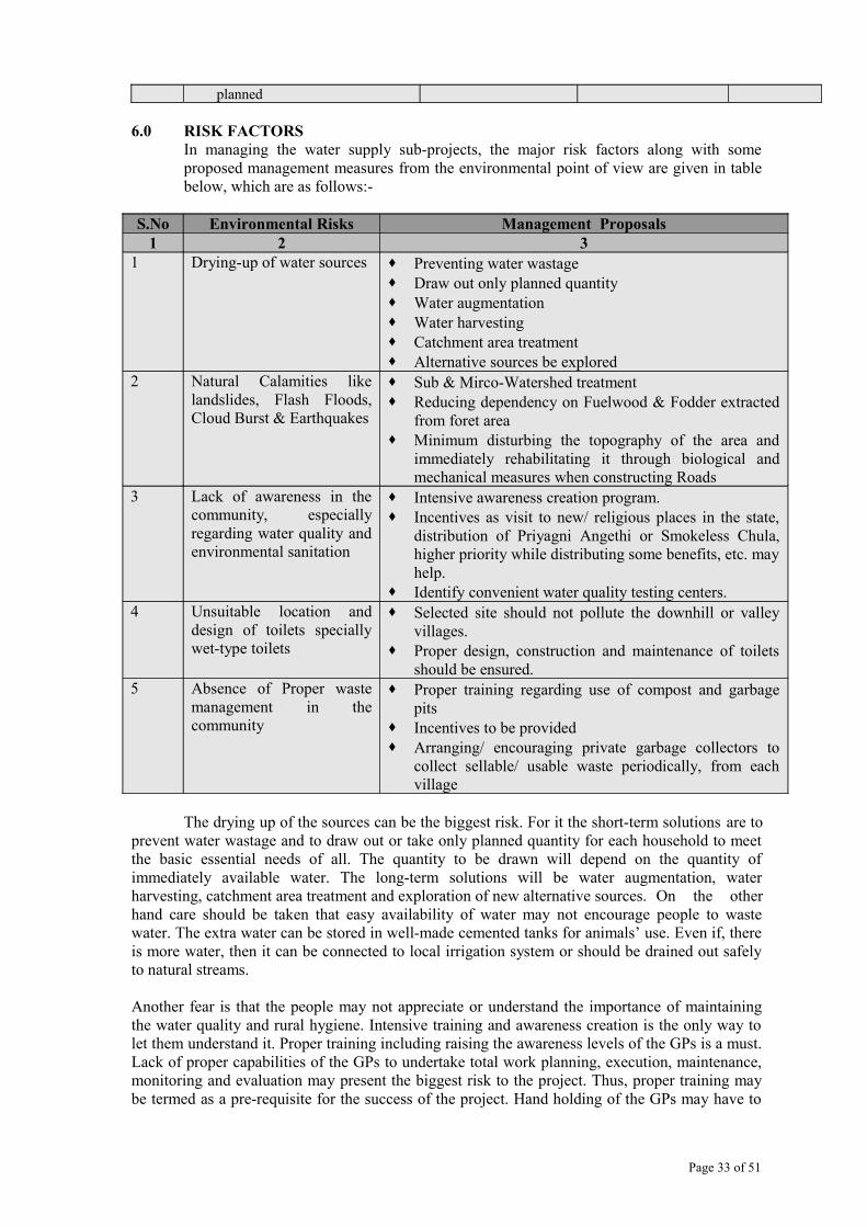
planned
6.0 RISK FACTORSIn managing the water supply sub-projects, the major risk factors along with some proposed management measures from the environmental point of view are given in table below, which are as follows:-
S.No Environmental Risks Management Proposals1 2 3
1 Drying-up of water sources Preventing water wastage Draw out only planned quantity Water augmentation Water harvesting Catchment area treatment Alternative sources be explored
2 Natural Calamities like landslides, Flash Floods, Cloud Burst & Earthquakes
Sub & Mirco-Watershed treatment Reducing dependency on Fuelwood & Fodder extracted
from foret area Minimum disturbing the topography of the area and
immediately rehabilitating it through biological and mechanical measures when constructing Roads
3 Lack of awareness in the community, especially regarding water quality and environmental sanitation
Intensive awareness creation program. Incentives as visit to new/ religious places in the state,
distribution of Priyagni Angethi or Smokeless Chula, higher priority while distributing some benefits, etc. may help.
Identify convenient water quality testing centers.4 Unsuitable location and
design of toilets specially wet-type toilets
Selected site should not pollute the downhill or valley villages.
Proper design, construction and maintenance of toilets should be ensured.
5 Absence of Proper waste management in the community
Proper training regarding use of compost and garbage pits
Incentives to be provided Arranging/ encouraging private garbage collectors to
collect sellable/ usable waste periodically, from each village
The drying up of the sources can be the biggest risk. For it the short-term solutions are to prevent water wastage and to draw out or take only planned quantity for each household to meet the basic essential needs of all. The quantity to be drawn will depend on the quantity of immediately available water. The long-term solutions will be water augmentation, water harvesting, catchment area treatment and exploration of new alternative sources. On the other hand care should be taken that easy availability of water may not encourage people to waste water. The extra water can be stored in well-made cemented tanks for animals’ use. Even if, there is more water, then it can be connected to local irrigation system or should be drained out safely to natural streams.
Another fear is that the people may not appreciate or understand the importance of maintaining the water quality and rural hygiene. Intensive training and awareness creation is the only way to let them understand it. Proper training including raising the awareness levels of the GPs is a must. Lack of proper capabilities of the GPs to undertake total work planning, execution, maintenance, monitoring and evaluation may present the biggest risk to the project. Thus, proper training may be termed as a pre-requisite for the success of the project. Hand holding of the GPs may have to
Page 33 of 51

be done for a long period, according to the local absorption capacity to work under changed circumstances.
Some incentives may be given to the people to encourage them to adopt the suggestions. The incentives can be: taking them to see success stories of neighboring districts or visit to some neighboring religious or tourist places. Distribution of some subsidized small household useful items as Priyagni Angethi, Smokeless Chula etc. may be a good incentive. The people who accept the program may be given higher priority while distributing items of some other program in the village. Regarding water quality, help in identification of convenient, easily accessible testing laboratories would be an incentive to get it done regularly.
Toilets especially the wet type with soak pits can concentrate contaminants in a small area. Therefore proper designing, construction and the follow-up maintenance is very important. In most of the villages there is no tradition of proper waste management. Therefore people will have to be trained and convinced to use compost and garbage pits. The sellable, non-biodegradable waste would be sorted out separately and sold out to professional garbage collectors periodically. The villagers could be encouraged to collect all sellable waste at one place for removal. Professional garbage collectors would be encouraged to contract a large areas (a block or a district or all the villages on a major road etc.) so that it may become remunerative for them. People accepting the proper waste management and sanitation may be provided with some incentives either from RWSS sector or from other village programs.
Page 34 of 51

ANNEXURE -I
ENVIRONMENTAL CODES OF PRACTICES (ECOPs)
The environmental codes of practices for different activities are given below to list-up various factors to be kept in mind, while undertaking these activities.
The ECOPs for eight major activities include the followings,
1. ECOPs for Identification of Sources of Water Supply2. ECOPs on Protecting Surface Water Supply Source and Ensuring Sustainability3. ECOPs on Protecting Ground Water Supply Sources and is Ensuring Sustainability4. ECOPs on Water Quality Monitoring5. ECOPs on selection of Safe Sanitation Technology Options (Including Drainage) at
Individual Household and Community Level6. ECOPs on Selection of Location for Community Toilets7. ECOPs on Safe Sullage Disposal and Organic Waste Management8. ECOPs on Safe Solid Waste Management at Individual Household and Community Level
Considering the diverse geo-hydrological and overall environmental conditions in Uttarakhand, the tools and mechanism proposed / codes should not be generalized – as it may require minor modifications in order to incorporate site specific constraints.
1. ECOPs FOR IDENTIFICATION OF SOURCES OF WATER SUPPLYOBJECTIVE: To lay down the criteria for selecting appropriate water sources for rural drinking water supply.
(I) Application – SPRINGSDetailed hydro-geological studies of 279 sites are given (in table 6.10 of EA study report). However, further site-specific geo-hydrological assessment in light of the following measures will provide a better insight for individual schemes.Measures Suggested –
There should be enough discharge especially in summers to meet the community’s needs (table 6.4 of EA study report).
The discharge rate of the source during the dry season should be considered as the average source discharge rate under the sub-project. In case of two years of observation, the minimum of the two discharge should be considered for working out safe yield of the source. Safety factors (due to processing, storage, transferring loses) be added on.
Water storage tank be made a little away (downhill-side) of the source. The source should not be disturbed by biotic and abiotic pressures. Source should not be within 100 m downhill side of a polluting point (Toilet and soak pit)
as per the Pey Jal Nigam guideline. Source should be above a village and not immediately below a hillside village. Source whose catchment is well – vegetated should be preferred. Source in a forested area be preferred than in agricultural area. The catchment having least anthropogenic interference will be preferred. There should not be any other uses of the source proving drinking water under the
scheme. The quality of water should be within the safe limits of Bureau of Indian Standard.
Page 35 of 51

(ii) Application – STREAMS
Measures Suggested – Discharge measurements taken in the dry seasons (may-June) should only to be
considered for designing the project. Preferably, the minimum discharge rate to be considered should be 75 % of the average of the two dry season’s minimum discharge recorded; as the minimum discharge capacity for the sub-project for designing purposes. Besides, these the source should have enough water left after tapping to maintain the stream ecology.
Proposed tapping point should be above the village path and not immediately below it. If animals drink water (or bath) from the same stream then their drinking/ bathing point should be below the proposed tapping point.
Water tapping point should not be below a polluting activity (drain discharge point etc).In case a particular source is already used for multipurpose, the planning team must ensure that the source has sufficient water to meet additional demand.
Water quality should be tested before installation of the scheme both for bacteriological and chemical pollutants.
2. ECOPs ON PROTECTING SURFACE WATER SUPPLY SOURCE AND ENSURING SUSTAINABILITY
Objective – To lay down criteria for sustaining water supply in a STREAMMeasures Suggested - While tapping surface water especially in case of small rivulets, one of the key issue that
needs to be addressed is the percentage of source discharge required to be tapped. The proportion to be tapped will depend on the other uses to which the water is being used now. If no other competing use of the water exists, about 1/3 rd of the lean period supply must be left to sustain the downstream ecology.
If possible a small well be dug or a 4 or 5 m. long 4” diameter perforated pipe be laid along the stream at about 60 cm. below ground and then connect it to the pipe taking water to the village. In this way cleaner water from the sand bed will be tapped.
Streams bank upto a few meters (say 10 m.) above tapping points be fenced to check any anthropogenic disturbance.
If possible a few check dams be made in the stream above the collection point to increase the water soaking and it will also improve the quality of water.
For wider streams, spurs will help instead of check-dams. Catchment area treatment will be done.
3. ECOPs ON PROTECTING GROUND WATER SUPPLY SOURCES AND IS ENSURING SUSTAINABILITY
Objective – To ensure sustainability of SPRINGSThe source has to be protected from physical damage and also be protected from any contamination due to its use by anybody (human or animals). Following proposals are given to protect a spring sources.
Measures Suggested - A brick/ concrete chamber will be made of about 2’ × 2’ × 2’ size around the spring mouth
with an iron gate made of close mesh and strong iron strips/ bars so that source is visible and well protected.
The area around the source required to be fenced. It can be of small size of about 2 m × 2 m, but should be sturdy so that animals may not breach it easily. Fencing be done by 4 to 5 strand barbed wire upto about 5’ ht., supported by wire net of 4” × 4“ to prevent animals to
Page 36 of 51
pass-in. Lower 3’ ht. be fenced by close mesh wire net and it must be embedded strongly (well nailed in) at least 9” below ground to prevent rodents etc. to enter by burrowing in.
For long term sustainability, catchment around the source be delineated and protect with the following measures, Free grazing of all animals must be restricted. If possible, protect the area from animals grazing with social fencing. Free animal grazing be restricted as animals dung, urine etc. can pollute water. Open defecation in the micro-mini-catchment should be discouraged. Vegetate the area with broad-leaved trees, bushes and grasses. Controlled grass cutting (close and open range) on contour strips should be adopted. If area has private fields and the land-use can not be altered then encourage only long
rotation crops with organic faming (preferable with horticulture species). The catchment should be kept under permanent vegetative cover All activities in the catchment be conducted on contours. Water barriers be made in the catchment in form of various types of check dams, gully
plugs, contour hedges etc. On wider streams, spurs will help. Water recharge will improve by digging narrow, shallow staggered (well protected by
grass) trenches. If needed the trench can be filled up by stones, etc. and grass planted down hillside of these trenches.
No land be left fallow in the catchment. Un-necessary disturbance (cattle movement etc.) the catchment be checked. Storm water can be led to abandoned wells, troughs etc. for subsoil water recharge. Old ponds, channels etc. can be cleaned and desilted to recharge the traditional sources.
4. ECOPs ON WATER QUALITY MONITORING
Objective – The objective is to provide user-friendly guidelines for water quality surveillance under the project.
Measures Suggested - Water should be tested before finalizing a source to tap for drinking water in line of the
norms stated in Sec. 6.3.1 of EA study report.
The critical pollutants load of the area must be identified prior to the installation of the schemes.
In case, water quality exceeding any permissible limit, villager must be explained regarding the mitigation measures
Water quality surveillance must be undertaken periodically in line of mitigation measures proposed in this EMF, particularly for coliform, parasites and chlorine residues. In case of any epidemic regular water sample testing must be encouraged.
Any water sample send for water sample analysis must be acidified immediately during collection and get the water sample analyzed/tested within 12 hours of collection.
Regular chlorination of the main storage tank is recommended and this should be undertaken in coordination with the Health Department. This institutional arrangement for such chlorination already exists in the state.
Open defecation in catchment area should be prevented. Toilets, garbage pits etc. within 30 m. above water source should be discouraged. Enclosed table A to G can help in collecting the data for water quality from different
types of sources. In case of spring sources chlorine dose could be 0.2 ppm while in case of Gadhera source
it should be 0.5 ppm.
Page 37 of 51
5. ECOPs ON SELECTION OF SAFE SANITATION TECHNOLOGY OPTIONS (INCLUDING DRAINAGE) AT INDIVIDUAL HOUSEHOLD AND COMMUNITY LEVEL
Objective – To suggest safe technology options to manage village waste water.Measures Suggested - The garbage should not be thrown in water channels as it chokes the system. Proper drainage for waste water must be developed around every common stand post and
at the outlet of household connection point, prolonged standing water or any other form of water congestion in any common point of the sub-project village must be discouraged to avoid any vector born diseases.
Drain should be of sufficient size to be able to take in all water without spill over. Gradient of drains be such that they themselves may not become gullies. In steep gradient portions drains should be made with cement and steps to be made at the
bottom. The drains should be taken out of village to the natural drainage point of the village
Gadera (local name of rivulet). One or two check dams be made in the Gadera below the point where drains are led into
the Gaderas. The outfall drain should be provided with the screened and a small grit chamber before
being disposed into drain or pond. Where disposal on land is proposed cultivation of Poplar or Eucalyptus trees should be promoted.
Drains level should not be above the ground level as the section may not remain intact and it also should not intercept with ground runoff water creating water logging along it.
For all intercepted drains at junction points where the fall is more that 30 cm, ramp drops should be provided.
Any drain crossing a village street should be covered with removable gratings, stone or RCC slabs in order to reduce the silt intrusion and better cleaning purposes.
Garbage pits for non-biodegradable waste should be managed at community levels in coordination with a professional waste disposal agency or with appropriate line departments.
6. ECOPs ON SELECTION OF LOCATION FOR COMMUNITY TOILETS
Objective – Criteria to select suitable site for locating toilets (at household level or at community level).
Measures Suggested - It may be constructed below a stream but not within 100 m above stream as already
prescribed by the Jal Sansthan. Many factors affect the safe distance between a ground water supply and source of
contamination. It is impractical to set fixed distances. As a rule, the distance should be the maximum that economics, land ownership, geology and topography will permit. If at all possible a well (or other water source as spring) be located on ground that is higher than source of contamination. Minimum distance recommended between water supply point and various sources of contamination is given in following table below:-
Table for Distance between possible contamination source and water intake pointContamination Source Well or section line distanceBuilding sewer 50 ft. (about 15 m.)Septic tank 50 ft. (about 15 m.)Disposal field 100 ft. (about 31 m.)Seepage pit 100 ft. (about 31 m.)Dry well 50 ft. (about 15 m.)Cess pool 150 ft. (about 46 m.)Source: Anon 1963 (EA study Report)
Page 38 of 51

7. GUIDELINES/ ECOPs ON SAFE SULLAGE DISPOSAL AND ORGANIC WASTE MANAGEMENT
Objective – Sullage and biodegradable waste be managed in a non-polluting, useful manner.
Measures Suggested - Compost pits be used for all organic waste. The table given in above section 6 may be used to determine the distance between
compost pit and water source. Wastewater be taken out of village through easy gradient drains. Make small troughs on drains at intervals to retard water velocity. It will also help in
sullage settlement and water aeration. All water drains be made to take water upto natural water discharge channels (Gaderas). Biogas plants be installed to use organic waste especially animal dung and human
excreta. No garbage should be thrown into the drains. Drains should be cleaned before and after monsoon.
8. GUIDELINES/ ECOPs ON SAFE SOLID WASTE MANAGEMENT AT INDIVIDUAL HOUSEHOLD AND COMMUNITY LEVEL
Objective : Safe management of biodegradable and non-biodegradable waste.
Measures Suggested - Biodegradable waste should be used to feed compost pits. Non-Biodegradable waste be collected separately by the community at a common point
(Garbage pit) in the village. Recyclable waste as glass, metal even polythene/ plastic can be sold, or permitted to be
collected by professionals from one common point of the village.
Page 39 of 51

Table A
Sanitary Survey Schedule for Assessment of Risks
of Contamination of Drinking Water Sources
I. Type of facility: DUGWELL
General information:
1. Location : Village .....................................................................................
: Gram Panchayat .....................................................................
: District .....................................................................................
2. Code No. .........................................../..................................../.............................................
3. Water authority/Panchayat Pradhan/Community Representative Signature
......................................................................................................
4. Date of visit ...................................................................................... Water Quality
5. Is water sample taken ? ........................... Sample No. ..................... Acceptable/ Rejected
II. Specific Diagnostic Information for Assessment Risk
Yes No1. Is there a latrine within 10 m of well ?2. Is the nearest latrine on a ground higher than well ?3. Is there any other source of pollution within 10 m of well
(e.g. animal excreta, rubbish) ?4. Is the drainage poor causing stagnant water within 2 m of well ?5. Is there a faulty drainage channel ? Is it broken, permitting pending ?6. Is there an inadequate parapet (less than 1 m) around the well which would allow surface
water to enter the well ?7. Is the cement floor less than 1 m wide round the well ?8. Are the walls of the well inadequately sealed at any point for 3 m below ground ?9. Are there any cracks on the cement floor around the well which could permit water to
enter the well ?10. Are the rope and bucket left in such a position that they may get contaminated ?11. Is the well covered (temporarily by mosquito net etc.)
Total score of risks ....................../11
Contamination risk score: 9-11= Very, High; 6-8= high; 3-5= intermediate; 0-2= low.
Number of “YES’ to be counted (list nos. 1-11)
III. Results and recommendations:
The following important points of risk (serially from top) were noted:
and the authority advised on remedial action
Signature of Investigator ....................................
Sanitary Survey Schedule for Assessment of Risks
of Contamination of Drinking Water Source.
Page 40 of 51

Table B
Sanitary Survey Schedule for Assessment of Risks
of Contamination of Drinking Water Sources
I. Type of facility: HANDPUMP ON DUGWELLGeneral information:
1. Location : Village......................................................................................: Gram Panchayat......................................................................: District .....................................................................................
2. Code No.............................../............................................./..................................................3. Water authority/ Panchayat Pradhan/ Community Representative Signature
...............................................................................................................................................4. Date of visit......................................................................................................Water Quality5. Is water sample taken?.......................Sample No...............................Acceptable/ RejectedII. Specific Diagnostic Information for Assessment Risk
Yes No1. Is there a latrine within 10m of hand pump ?2. Is the nearest latrine on a ground higher than hand pump ?3. Is there any other source of pollution within 10m of hand pump4. (e.g. animal excreta, rubbish)?5. Is the drainage poor causing stagnant water within 2 m of hand pump?6. Is there a faulty drainage channel? Is it broken, permitting pending ?7. Is the cement floor less than 1m wide round the hand pump ?8. Is there any pond formation on the cement floor around the hand pump ?9. Are there any cracks on the cement floor around the hand pump ?10. Is the bucket also in use and left in a place where it could get contaminated ?11. Is the hand pump loose at the point of attachment of base (which could permit water to
enter the casing ?12. Is the cover of the well in sanitary ?13. Are the walls of the well inadequately sealed at any point for 3 m below ground level ?
Total score of risks............................./12
Contamination risk score: 9-11 = Very, high; 6-8=high; 3-5=intermediate; 0-2=low.Number of 'YES’ to be counted (list nos. 1-12)III. Results and recommendations:
The following important points of risk (serially from top) were noted:and the authority advised on remedial actionSignature of Investigator......................................................................Sanitary Survey Schedule for Assessment of Risksof Contamination of Drinking Water Sources
Page 41 of 51

Table CSanitary Survey Schedule for Assessment of Risks
of Contamination of Drinking Water Sources
I. Type of facility: SHALLOW AND DEEP HAND PUMPS (TUBEWELL)
General information:
1. Location : Village......................................................................................
: Gram Panchayat......................................................................
: District .....................................................................................
2. Code No.............................../............................................./..................................................
3. Water authority/ Panchayat Pradhan/ Community Representative Signature
...............................................................................................................................................
4. Date of visit......................................................................................................Water Quality
5. Is water sample taken?.......................Sample No...............................Acceptable/ Rejected
II. Specific Diagnostic Information for Assessment Risk
Yes No1. Is there a latrine within 10 m the hand pump ?2. Is me nearest latrine on a higher ground than the hand pump ? (a pit latrine that percolates
to soil) ?3. Is mere any other source of pollution within 10 m of the hand pump?
(e.g. animal excreta, rubbish, surface water)4. Is me drainage poor causing stagnant water within 2 m of the cement floor of
hand pump?5. Is there a faulty drainage channel ? Is it broken ? Does it need cleaning ?6. Is the cement floor less than 1m wide round the hand pump?7. Is mere any ponding on the cement floor around the hand pump ?8. Are there any cracks on the cement floor around the hand pump ?9. Is priming of tube well required during the season ?
Total score of risks............................./9
Contamination risk score: 9-11 = Very, high; 6-8=high; 3-5=intermediate; 0-2=low.
Number of 'YES’ to be counted (list nos. 1-9)
III. Results and recommendations:
The following important points of risk (serially from top) were noted:
and the authority advised on remedial action
Signature of Investigator......................................................................
Sanitary Survey Schedule for Assessment of Risks
of Contamination of Drinking Water Sources
Page 42 of 51
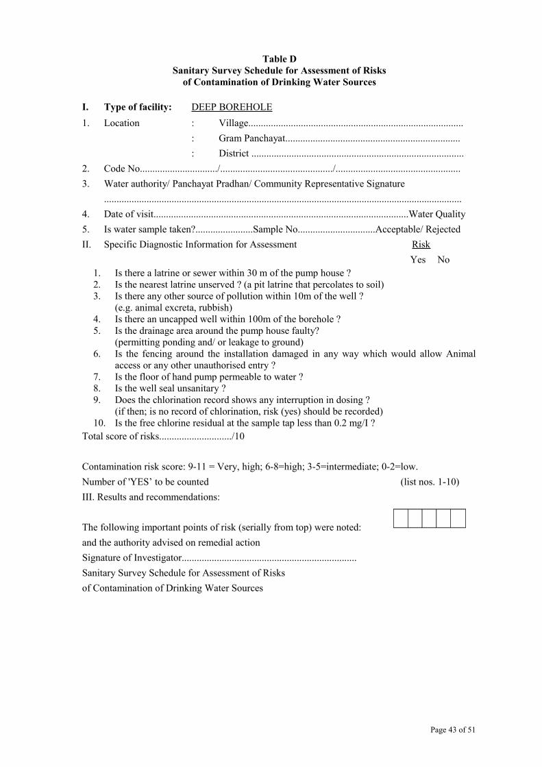
Table DSanitary Survey Schedule for Assessment of Risks
of Contamination of Drinking Water Sources
I. Type of facility: DEEP BOREHOLE
1. Location : Village......................................................................................
: Gram Panchayat......................................................................
: District .....................................................................................
2. Code No.............................../............................................./..................................................
3. Water authority/ Panchayat Pradhan/ Community Representative Signature
...............................................................................................................................................
4. Date of visit......................................................................................................Water Quality
5. Is water sample taken?.......................Sample No...............................Acceptable/ Rejected
II. Specific Diagnostic Information for Assessment Risk
Yes No1. Is there a latrine or sewer within 30 m of the pump house ?2. Is the nearest latrine unserved ? (a pit latrine that percolates to soil)3. Is there any other source of pollution within 10m of the well ?
(e.g. animal excreta, rubbish)4. Is there an uncapped well within 100m of the borehole ?5. Is the drainage area around the pump house faulty?
(permitting ponding and/ or leakage to ground)6. Is the fencing around the installation damaged in any way which would allow Animal
access or any other unauthorised entry ?7. Is the floor of hand pump permeable to water ?8. Is the well seal unsanitary ?9. Does the chlorination record shows any interruption in dosing ?
(if then; is no record of chlorination, risk (yes) should be recorded)10. Is the free chlorine residual at the sample tap less than 0.2 mg/I ?
Total score of risks............................./10
Contamination risk score: 9-11 = Very, high; 6-8=high; 3-5=intermediate; 0-2=low.
Number of 'YES’ to be counted (list nos. 1-10)
III. Results and recommendations:
The following important points of risk (serially from top) were noted:
and the authority advised on remedial action
Signature of Investigator......................................................................
Sanitary Survey Schedule for Assessment of Risks
of Contamination of Drinking Water Sources
Page 43 of 51

Table ESanitary Survey Schedule for Assessment of Risks
of Contamination of Drinking Water Sources
I. Type of facility: GRAVITY FED PIPED SPRING WATER SYSTEM
1. Location : Village......................................................................................
: Gram Panchayat......................................................................
: District .....................................................................................
2. Code No.............................../............................................./..................................................
3. Water authority/ Panchayat Pradhan/ Community Representative Signature
...............................................................................................................................................
4. Date of visit......................................................................................................Water Quality
5. Is water sample taken?.......................Sample No...............................Acceptable/ Rejected
II. Specific Diagnostic Information for Assessment Risk
Yes No
1. Is the source unprotected by masonry or concrete wall or spring box(open to surface contamination) ?
2. Is the masonry protecting the source faulty ?3. Does the spring box contain contaminating silt or animals ?4. If there is an overflow pipe, is it unsanitary ?5. Is the area around spring unfenced ?6. Can animals have access within 10m of the spring source ?7. Is the spring lacking a surface water diversion ditch above it, or (if present) is
It non-functional ?8. Is there any latrine upstream of the spring?
Total score of risks............................./8
Contamination risk score: 9-11 = Very, high; 6-8=high; 3-5=intermediate; 0-2=low.
Number of 'YES’ to be counted (list nos. 1-8)
III. Results and recommendations:
The following important points of risk (serially from top) were noted:
and the authority advised on remedial action
Signature of Investigator......................................................................
Sanitary Survey Schedule for Assessment of Risks
of Contamination of Drinking Water Sources
Page 44 of 51

Table FSanitary Survey Schedule for Assessment of Risks
of Contamination of Drinking Water Sources
I. Type of facility : GRAVITY FED PIPED SUPPLIES
1. Location : Village......................................................................................
: Gram Panchayat......................................................................
: District .....................................................................................
2. Code No.............................../............................................./..................................................
3. Water authority/ Panchayat Pradhan/ Community Representative Signature
...............................................................................................................................................
4. Date of visit......................................................................................................Water Quality
5. Is water sample taken?.......................Sample No...............................Acceptable/ Rejected
II. Specific Diagnostic Information for Assessment Risk
Yes No1. Is there any point leakage between the source and the reservoir ?2. Is there any pressure break box, are their covers unsanitary ?3. Is the inspection cover on the reservoir unsanitary ?4. Are any air vents unsanitary?5. Do the roof and walls of the reservoir allow any water to enter (is the reservoir cracked?)6. Is the reservoir water unchlorinated ?7. Does the matter entering the distribution pipes have less than 0.4 ppm pressure residual
chlorine (<0.4 mg/I) ?8. Are there any leaks in any part of the distribution system ?9. Is pressure low in any part of the distribution system ?10. Does any sample of water in the principal distribution pipes have less than 0.2 ppm free
residual chlorine ?Total score of risks............................./8
Contamination risk score: 9-11 = Very, high; 6-8=high; 3-5=intermediate; 0-2=low.
Number of 'YES’ to be counted (list nos. 1-8)
III. Results and recommendations:
The following important points of risk (serially from top) were noted:
and the authority advised on remedial action
Signature of Investigator......................................................................
Sanitary Survey Schedule for Assessment of Risks
of Contamination of Drinking Water Sources
Page 45 of 51
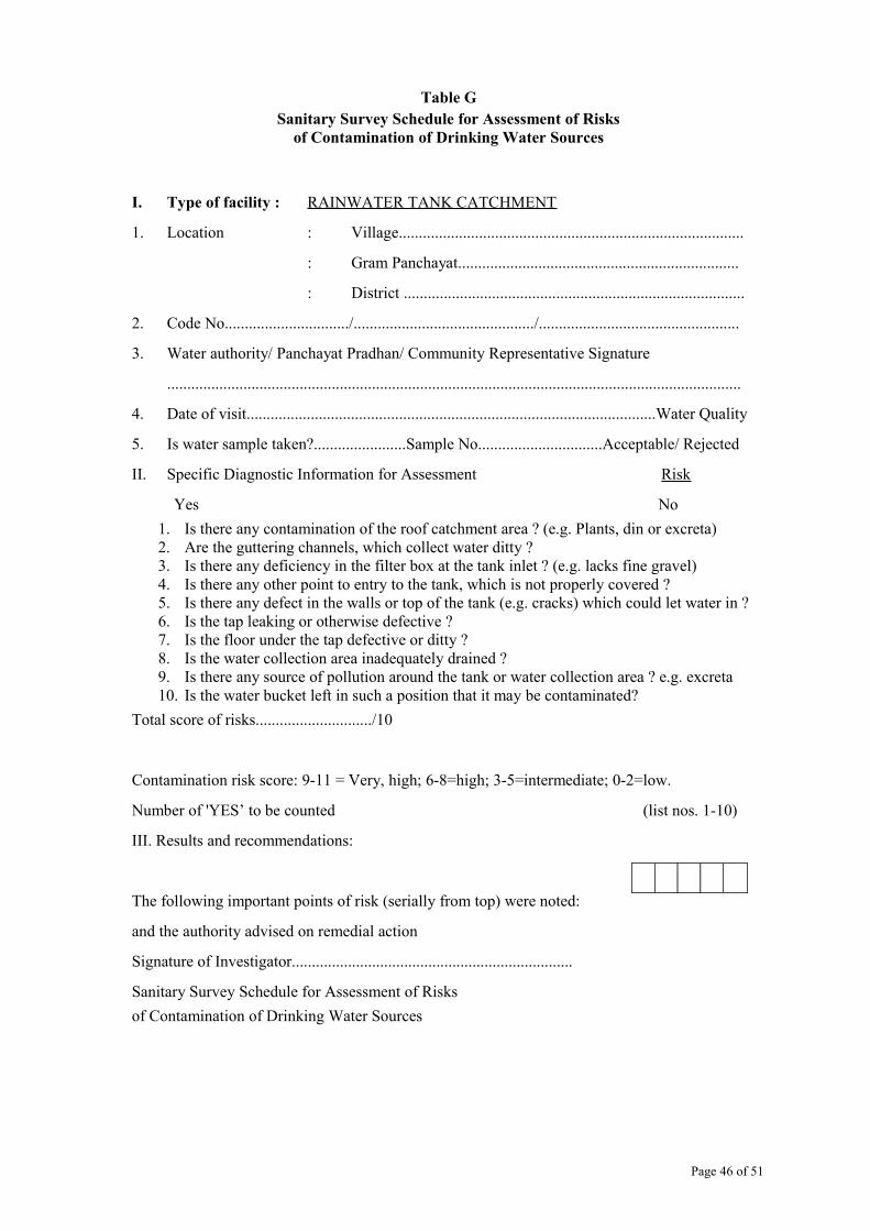
Table GSanitary Survey Schedule for Assessment of Risks
of Contamination of Drinking Water Sources
I. Type of facility : RAINWATER TANK CATCHMENT
1. Location : Village......................................................................................
: Gram Panchayat......................................................................
: District .....................................................................................
2. Code No.............................../............................................./..................................................
3. Water authority/ Panchayat Pradhan/ Community Representative Signature
...............................................................................................................................................
4. Date of visit......................................................................................................Water Quality
5. Is water sample taken?.......................Sample No...............................Acceptable/ Rejected
II. Specific Diagnostic Information for Assessment Risk
Yes No
1. Is there any contamination of the roof catchment area ? (e.g. Plants, din or excreta)2. Are the guttering channels, which collect water ditty ?3. Is there any deficiency in the filter box at the tank inlet ? (e.g. lacks fine gravel)4. Is there any other point to entry to the tank, which is not properly covered ?5. Is there any defect in the walls or top of the tank (e.g. cracks) which could let water in ?6. Is the tap leaking or otherwise defective ?7. Is the floor under the tap defective or ditty ?8. Is the water collection area inadequately drained ?9. Is there any source of pollution around the tank or water collection area ? e.g. excreta10. Is the water bucket left in such a position that it may be contaminated?
Total score of risks............................./10
Contamination risk score: 9-11 = Very, high; 6-8=high; 3-5=intermediate; 0-2=low.
Number of 'YES’ to be counted (list nos. 1-10)
III. Results and recommendations:
The following important points of risk (serially from top) were noted:
and the authority advised on remedial action
Signature of Investigator......................................................................
Sanitary Survey Schedule for Assessment of Risks
of Contamination of Drinking Water Sources
Page 46 of 51
ANNEXURE-II
FOREST LAND TRANSFER ON LEASEFOR CONSTRUCTION OF DRINKING WATER SUPPLY SCHEMES
(a) The district-wise land utilization data for the State of Uttarakhand shows that in Uttarakhand 62.28% (34661.52 sq. km) is Forestland, 14.5% (8097 sq km) is Agriculture land, 3.84 % (2151 sq km) is under Horticulture and 4.05 % (2266 sq km) under pasture, out of the recorded area of 55658.04 sq km.
Since the project is demand based, with entire state as its project area, majority of the water sources for construction of Drinking Water Supply scheme would be situated in the Reserved Forest areas and areas under the control of Forest Department of the State. Hence forestland transfer has to be done in majority of schemes.
In the first phase of the proposed project (Swajal Project-Phase-I), nearly in 111 villages, forestland transfer was done. The maximum area transferred was around 0.62 ha. In most of the schemes, the land transferred was around 0.2 ha. The cost of the land to be transferred depends upon the area and is provided by the schedules of rates of the area, which is calculated by the concerned district authorities. To this is added, the annual lease rent, which is 10 % of the transferred land cost.
Recently the Govt. of India, as per the direction of the Supreme Court of India, has introduced the concept of Net Present Value which has also to be added and paid in addition to the transferred land cost and annual lease rent. The net present value is calculated on the basis of forest density of the area and quantity of land to be transferred. As per the guidelines, for transfer of land with forest density up to 10 %, the NPV is Rs 0.58 million per hectare. For forest density between 10%-40%, the NPV is Rs 0.75 million per hectare and land with forest density of 40 % and above, the NPV is Rs 0.92 million per hectare. Since in the proposed project, the number of schemes requiring forest land transfer would be around 687 (50% of 1374 schemes) with average forest density in between 10 % to 40 %, the NPV is to be added, which would be around Rs 103.05 million. Since Sector Wide Approach will be followed in Single Village Schemes, therefore the choice of selection of sources for Single Village Schemes will not be limited and the villagers may select a more feasible source in the reserved forest area. Hence it is assumed that, 0.2 ha. forestland may be required for construction of water supply scheme.
Regarding the payment for the cost of the land transfer and annual lease rent (excluding NPV), the State Govt. vide order No. 3600/Finance Section-3/2003 dated Feb 4, 2003, has declared the present Sector Institutions (Jal Nigam & Jal Sansthan) as Service Departments. These institutions now do not have to pay the cost of the transferred land and the annual premium for construction of Water Supply Scheme. Efforts are being made to include this project, within the purview of this order.
The transfer of forestland up to 01 hectare, for the purpose of construction of drinking water supply scheme can be done by the State, vides GOI Letter No. F.No.11-9/98-FC dated 03-01-2003.(b) Procedure for Land Transfer:
The forestland lease will be taken up by the Gram Panchyats. The proposal of forest land transfer for construction of water supply scheme is prepared by the District Unit of the project, on behalf of GP’s, in consultation with the Revenue and Forest Departments and sent to the Government, which in turn after verification, can transfer forest land up to one hectare, with certain regulation to be followed.
Page 47 of 51

Annexure-III
Table Showing Cost for Source Centered Treatment for One Water Supply source/Scheme under Catchment Area Conservation and Management Program
S.No
Item of Work Size Specification
Unit Quantity Proposed rate INR
Amount INR
Percentage of the Sub component
cost1 Biological Works
aAfforestation including Fencing 1000/Ha Ha 5 21150 105750
b Demo Grass patch 200 Sq.mt Nos. 1 2000 2000 Sub Total A 107750 82
2 Soil Conservation Works
a
R.R Dry Stone Check Dam
Stone Check Dam in 5 Ha of 7.37 Cum Cum 7.37 350 2579.5
b
Crate Wire Check Dam Crate wire check dam in 5 Ha of 8.4 Cum
Cum 8.4 620 5208
c Brush wood Check Dam per Ha Nos 5 500 2500 Sub Total B 10287.5 8
3 Rain Water Harvesting Structures for Ground Water Recharge
a Percolation ponds 2 per Ha of 15.19 cum each Nos 30.38 40 1215.2
b Recharge Pit
5per ha of 0.125 Cum each cum 3.125 40 125
cRejuvenation of Existing Chaal/khaal
100 Cum of Excavation Cum 100 40 4000
Sub Total C 5340.2 44 Social Measures
a
Social Fencing/awareness, LPG & Environmental Sanitation Awareness Campaign Activity No 1 5000 5000
bPoly House (7.5*4*2) Bamboo based Activity No 1 2500 2500
Sub Total D 7500 6 Grand Total Cost for a Scheme(A+B+C+D) 130,878 Grand Total Cost for 1000 sources/Schemes 130877700 Cost in Million US $ 3.0 100
Page 48 of 51

Table Showing Cost for Advance Soil Working and Plantation Works in Forestry Plantation per Ha (as part of source protection measures)
S.No Particulars Unit Quantity Unit Rate (Rs.)
Amount (Rs.)
A Advance Soil Works 1 Survey and Demarcation Ha 1 30 302 Sit Clearance (Shrub Cutting) Ha 1 400 4003 Fencing Works (Coolie wall/ Barbed wire Fencing) Rmt/Cum 1 6592 6592
4 Pit Digging (30*30*45 cm) Nos 1000 2.06 20605 Digging of Contour Trenches (300Rmt per
ha,0.3*0.3 M)Rmt 300 2.23 669
6 Cost of plants (1st Year) Nos 1000 3 3000 Miscellaneous Expenditure 7 Cost of tools, lime, basket, Rope, and pit digging
for water recharging Ha 1 123 123
8 Cost of fertilizers for trenches and pits (25 kg)@25 g/pit
Kg 25 10 250
Sub Total A 13124B Planting Works 1 Filling of Pits(30*30*45 cm) Nos 1000 0.35 3502 Seed sowing on trenches (300 rmt per ha) Rmt 300 0.29 87
3 Transportation of plants(25% naked & 75% bag plants average 25 Km by vehicle & 3 Km head load including loading, unloading
Nos 1000 2.5 2500
4 Planting and hoeing Nos 1000 0.7 7005 Weeding 2 times and mulching Nos 1000 0.75 7506 Expenditure on Manure Nos 1000 2 20007 Contour trench Filling (300Rmt) Rmt 300 0.58 1748 Collection and removal of dry grasses & dry fallen
wood for protection of fire ha 1 100 100
9 Cost of grass seed 5 Gram per Rmt Kg 1.5 200 30010 Cost of shrubs seed 0.10 gm per rmt Kg 3 100 30011 Cost, planting and cartage of Napier cutting (300
cutting per Ha)Nos 300 0.35 105
12 Cultural Operation, singling, natural regeneration within plantation area (average 200 plants per Ha)
Nos 200 0.55 110
13 other expenditure such as sharpening of tools etc. Ha 1 550 550
Sub Total B 8026 Grand Total A+B 21150Note: No watcher has been proposed for watch and ward of the plantation area. The community will take care of this activity.
Page 49 of 51

Table showing specifications for construction of Crate wire Stone Check Dam (as part of source protection measures)
S.No Particulars No Measurements (M) Earth Works Cum
Stone Works Cum
L W H1 Earth Work In
foundation 1 3.5 2.2 0.5 3.85 0
2 Stone work in foundation
1 3.5 2.2 0.5 0 3.85
3 Stone work in super structure
1 3.5 1 0.8 0 2.8
4 Stone work in crest wall 2 1.75 1 0.5 1.75 G.I Wire In Foundation 2 3.5 2.2 Top/Front/Back 2 3.5 0.5 In Side 2 2.2 0.5 Super Wall Front/Back 2 3.5 0.8 In Top 1 3.5 1 In Side 2 1 0.8 Crest Wall Front/Back 4 1.75 0.5 In Side 4 1 0.5 In Top 2 1.75 1 Total 3.85 8.4
Table showing specifications for construction of Grass patch (200 Sq.mt)S.No Description Unit Quantity Unit
Rate (Rs.)
Amount (Rs.)
1 Clearance of site (1 Man day) Sq.mt 200 0.5 1002 Digging soil 25-30 cm deep &
collection of Kankar from soil ( 2 times, 2 Man days)
Sqmt 400 0.5 200
3 Preparing Beds(10*10*1 cm) Nos 2 60 1204 Mixing sand & Manure in the Soil Sqmt 200 0.6 1205 Sowing seed, watering 3 months
(2days*1 Hour in a week)Activity 24 12 288
6 Vegetative Protection wall for protection of grass
Man Days
6 100 600
7 Cost of seed Kg 0.5 300 1508 Cost of DAP and Urea Kg 1 10 109 Transportation of sand,manure Activity 1 120 120
10 Maintenance of Grass patch(3 months)
Activity 3 100 300
Total 2008
Page 50 of 51

Table showing specifications for construction of Percolation Pond
S.No Particulars No Unit Measurements (M) QtyL W H
1 Excavation of foundation with soil mixed shingle
boulder etc.
1 Cum 4.5 4.5 0.75 15.19
Total 15.19
Table showing specifications for construction of Recharge Pit
S. No.
Particulars No Unit Measurements (M) Qty
L W H1 Excavation of foundation
with soil mixed shingle boulder etc.
1 Cum 0.5 0.5 0.5 0.125
Total 0.125
Table showing specifications for construction of Stone Check Dam
S.No
Particulars No Measurements (M) Earth Works Cum
Stone Works Cum
L W H1 Earth Works in
Foundation 1 2.8 2.2 0.6 3.69
2 Stone work in Foundation 1 2.8 2.2 0.6 3.693 Stone Work in Super
Wall1 2.8 1 1.3 3.64
Total 3.69 7.33
Page 51 of 51