using google earth - unite us · pdf fileunite us ©2010 - 2012 geophysical institute, uaf...
TRANSCRIPT

UNITE US ©2010 - 2012 Geophysical Institute, UAF Using Google Earth
USING GOOGLE EARTH
Overview:Learn how to use Google Earth™.
Note:If computers are not already equipped with Google Earth, download it for free at http://earth.google.com.
Launch:Launch Google Earth by double clicking on its icon.
Moving around Moving around in Google Earth can be done a couple of different ways.
a) The most common way to move is by using the “hand” icon controlled by the mouse. Click on Earth and hold the button down. Rotate earth so Alaska is visible.
b) Another way to navigate is to use the navigation controls on the upper right side of the screen.
If the navigation controls are not visible, check to make sure they are turned on by going to View Show Navigation Automatically (or Always).
Hand used for moving Google Earth
Navigation controls

UNITE US ©2010 - 2012 Geophysical Institute, UAF Using Google Earth
USING GOOGLE EARTH
Zooming in and out.Move the zoom slider towards the + sign to zoom in. To zoom back out move the slider towards the — sign.
As you zoom into Alaska, notice the different tiles that make up the mosaic of the state. The mosaic of images in a section could be made up of images taken in different years. Zoom into different areas and observe the differences in the quality or detail in the images.
Changing the tilt and direction.Zoom into an area and move the Look joystick toward the top. The surface of the earth will tilt.
Move the compass around in a complete circle and fly around the area. Moving the Look joystick will also change the view.
To practice moving around in Google Earth try following the Pipeline from Prudhoe Bay to Valdez.
Finding locationsFinding town, rivers, etc. is relatively easy if you know their approximate location. For example you will probably be able to find Anchorage and the Yukon River by zooming in and moving around the state. Try it for yourself.
Instead of looking around for a location, you can speed up the search by typing the name of the location in the Search box. For example, if you were looking for Barrow, Alaska you would simply type Barrow, AK in the search box, press return and let Google Earth take you there.
Using CoordinatesA geographic coordinate system can be used to define a location on earth. The most common system uses latitude and longitude. Both latitude and longitude are measured in degrees symbolized with a “°”. Degrees of latitude and longitude are divided into 60 minutes and are symbolized with a “’ ”. Minutes are divided into 60 seconds and are symbolized with a “ ” “. An example of a coordinate is as follows: 134° 45’ 53”. In addition coordinates can be expressed in degrees, minutes seconds, degrees decimal minutes, or decimal degrees. For example, 71° 25’ 43” is the same as 71° 25.7166’ in decimal minutes or 71.428611° in decimal degrees. Although each is used, decimal degrees is becoming more common since it can be entered and sorted in a spreadsheet as a complete coordinate. In Google Earth coordinates can be entered in any of the three formats.
Compass
Look joystick
Move joystick
Zoom slider
UNITE US ©2010 - 2012 Geophysical Institute, UAF Using Google Earth
USING GOOGLE EARTH
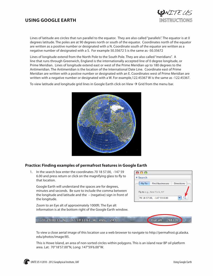
Lines of latitude are circles that run parallel to the equator. They are also called “parallels”. The equator is at 0 degrees latitude. The poles are at 90 degrees north or south of the equator. Coordinates north of the equator are written as a positive number or designated with a N. Coordinate south of the equator are written as a negative number of designated with a S. For example 50.35672 S is the same as -50.35672
Lines of longitude extend from the North Pole to the South Pole. They are also called “meridians”. A line that runs through Greenwich, England is the internationally accepted line of 0 degree longitude, or Prime Meridian. Lines of longitude extend east or west of the Prime Meridian up to 180 degrees to the Antimeridian. The Antimeridian is the location of the International Date Line. Coordinate east of Prime Meridian are written with a postive number or designated with an E. Coordinates west of Prime Meridian are written with a negative number or designated with a W. For example,122.45367 W is the same as -122.45367.
To view latitude and longitude grid lines in Google Earth click on View Grid from the menu bar.
Practice: Finding examples of permafrost features in Google Earth1. In the search box enter the coordinates 70 18 57.00, -147 59
6.00 and press return or click on the magnifying glass to fly to that location.
Google Earth will understand the spaces are for degrees, minutes and seconds. Be sure to include the comma between the longitude and latitude and the – (negative) sign in front of the longitude.
Zoom to an Eye alt of approximately 1000ft. The Eye alt information is at the bottom right of the Google Earth window.
To view a close aerial image of this location use a web browser to navigate to http://permafrost.gi.alaska.edu/photos/image/85.
This is Howe Island, an area of non-sorted circles within polygons. This is an island near BP oil platform area. Lat: 70°18’57.00”N, Long: 147°59’6.00”W.

UNITE US ©2010 - 2012 Geophysical Institute, UAF Using Google Earth
USING GOOGLE EARTH
2. Enter the coordinates 65 57 49.34, -161 7 54.07 in the Google Earth search box and press return.
This is Buckland, an area of low-centered polygons. Buckland has an interesting feature. Zoom in see how alders are coming in around the perimeters of the polygons. This is unusual because it is not normal for alders to be in an ice area but they seem to love this area. Lat: 65°57’49.34”N, Long: 161° 7’54.07”W
3. Enter the coordinates 67 48 41.65, -149 48 59.83 in the Google Earth search box and press return. Use the zoom, tilt and compass to view the location from different angles.
This is a debris glacier visible from the Dalton Highway Haul Road. Also see the aufice (overflow ice) to the left. This type of ice deposit is typical of permafrost during spring and summer. This area used to be a lake. Latitude: 67°48’41.65”N Longitude: 149°48’59.83”W
4. Navigate to your community. Is there any terrain that shows evidence of permafrost?