using geographical chapter information - john wiley &...
TRANSCRIPT

Using GeographicalInformation
Are you going somewhere in the next few days?
Have you thought about how you are going to get there?
Have you thought about what might be there when you arrive?
Geographical information systems like Google Maps and Google Earth cananswer these questions and, with a little work on your part, many more.They enable your computer to think about information in terms of a physi-cal, real-world location and then associate data with that location.
Understanding Your LocationWhen you think about your current location — whether you’re at home, atwork, or even at the beach — do you realize how often you think about whatis around you? If you were able to monitor your every thought, you’d proba-bly be surprised at how often you consciously and subconsciously thinkabout your environment.
Mapping a LocationHumans, on the whole, are very spatial creatures. We frequently think aboutand mentally map the information, places, and items around us — from thesmaller things, such as curbs and sidewalks, to the larger components, suchas the locations of mountains, buildings, and even entire towns and cities.But many humans take for granted the ability to locate and produce a men-tal map of where we are and where we want to go. (Some of us are better atthis than others, mind you!)
Typically, the human brain collects information while simply walking ordriving about. Subconsciously, and sometimes consciously, it’s fairly com-mon to think about the following:
˛ Find out the wayslocation can bedefined
˛ Learn how to thinkin terms of location
chapter
in this chapter
05_790095 ch01.qxp 6/12/06 1:30 PM Page 3
COPYRIG
HTED M
ATERIAL

4 Part I — Basics
� Locations of restrooms, police stations, information booths, and other useful places.
� Locations and names of restaurants or coffee bars.
� Interesting-looking buildings or places (such as castles, ruins, or statues).
� Routes to and from locations, including identifying whether a pathway meets up with apast location (somewhere you have been before).
You don’t always, however, want to investigate an area and make a mental map of all this infor-mation. Suppose, for example, that you want to find a restaurant within a few blocks of yourcurrent location. Determining this information by walking about and collecting the data couldtake hours, by which time you would be much hungrier than when you started — and you stillmay not have found what you were looking for.
This is why Google Maps and Google Earth are so useful. At their core, they provide mapping(Google Maps) and aerial photography (Google Earth) of many areas of the planet. In addi-tion, Google Maps connects the location information with data about businesses and othersites in the local area, allowing you to find all the restaurants or copy shops or any other type ofbusiness within a given area.
As a further expansion of the technology, Google Maps enables you to create applications thatcombine the mapping or earth information with your own set of data so that you can build cus-tomized views of information, all mapped to the geographical location of the items.
This technology can be used for a number of purposes, including (but not limited to) obtainingthe following information:
� Localized data: You can find all of the restaurants (or any other type of business youchoose) within a few miles of exactly where you are now.
� Maps and routes: You can find out where you are now and then how to get to otherplaces.
� Topographical views: You can get an idea of exactly where you are in relation to othercomponents, such as hills or ruins.
� Relation of locations to photographs: You can work out where you were standing andin which direction you were pointing the camera when you took a particular photograph.
� Statistical data: You can describe statistical data (such as population levels) by showingit graphically on a map, rather than by providing a basic list.
To make the best of this functionality, however, you need to change the way you think aboutyour environment.
Defining a LocationYou can describe your current location in several ways, usually depending on the level of civi-lization in your vicinity.
05_790095 ch01.qxp 6/12/06 1:30 PM Page 4

5Chapter 1 — Using Geographical Information
With an AddressSuppose you are interested in the National Maritime Museum in Greenwich, London. Towrite to the museum, you would use this simple address, along with the postal code SE10 9NF.(Postal codes are known by the post office and indicate a more specific location than just thetown or city.)
But if you are on the ground and need to actually locate the building for a visit, you need some-thing more specific; Greenwich is too large a district to have to search on foot. You need astreet name (in this case, Park Row) in order to locate the museum’s precise position. Havingthis information will help you find the correct street sign (if you already happen to be in thevicinity) or look up the street on a map.
Both of these address options — using just the postal code and using the full street address —have meaning only because the city of Greenwich has well-defined locations, identified in aformat that humans can easily understand. They are useful only if you know where a location isin terms of other places (for example, the street name “Park Row” is useful only if you know itis the Park Row in Greenwich, London) and if you have a well-indexed map that shows youthat location.
Without an AddressBut what about areas that are neither subject to human habitation nor blanketed by roads, suchas the Lake District in England or Yellowstone National Park in the United States?
In these situations, assigning an address is basically impossible. A much better solution is to usea map grid reference. Grid references give you a two-dimensional reference (horizontal andvertical) for a given location and are unique to the map you are using. Within the confines of asingle local map, a reference like A6 or TQ 387 776 GB Grid (the Ordinance Survey grid ref-erence for the museum) works quite well.
In a global environment, the grid reference is the combination of longitude and latitude.Longitude is the number of degrees, minutes, and seconds east or west of the prime meridianline. Latitude is the number of degrees, minutes, and seconds north or south of the equator.The combination of the two gives you a precise east/west and north/south location on theearth. Each half of the earth has 180 degrees.
The National Maritime Museum is on the prime meridian point, which is the home ofGreenwich Mean Time and the reference point for longitude references and time differencesbetween countries. Its longitude is, therefore, 0° 0’ 0”. Because the museum isn’t on the equator,its latitude is 51° 28’ 38”.
Normally, however, you quote only degrees and minutes (not seconds) in the longitude and lat-itude references. Thus, the location of Greenwich is 51.28N 0E. For Washington, D.C., use47.30N 120.30W; for Beijing, 39.55N 116.20E; and for Jakarta, 06.09S 106.49E.
Each of the references discussed in this section is useful in its own way, and you’ll use all of themas a method for identifying information. Remember to consider them when you look at differentdata types and think about how you can map them to geographical locations. Also make sure totake into account the direction in which you are facing when you orient yourself on a map.Because your orientation affects what you can see, it becomes important when you build appli-cations that can use this information.
05_790095 ch01.qxp 6/12/06 1:30 PM Page 5

6 Part I — Basics
Moving to Another LocationOnce you know current location and the location of your destination, you need to work out thebest route between them. Movement between locations is generally either direct (commonlyreferred to as “as the crow flies”) or via roads. Once again, the environment will likely deter-mine the route you choose.
If you are on foot or in the car and within a city, you will probably follow the road to your des-tination. The likelihood of being able to walk directly through a building (let alone drivethrough it!) is not great.
Within the countryside, especially if you are on foot, a more direct route (as opposed to travel-ing by road) will save you a lot of time. When traveling by plane, you’ll probably use the directroute, as well.
Knowing how you are going to move between different locations is important when using geo-graphical systems. You need this information not only to move between the areas, but also togain information about your environment (for example, the distance between two points or thetotal area).
Thinking in Terms of Geographical LocationThe first step in making use of geographical information is to change the way you think aboutthe word “information” in general. You need to think about information in terms of how itrelates to its geographical location, rather than as the simple data it may describe. To do thisyou must change the key you use to identify the information.
To Find PlacesImagine that you are stranded on the main street of a typical town, such as my hometown ofGrantham. Although you know where you are, you are clueless about your surroundings. Youdo, however, have access to a computer.
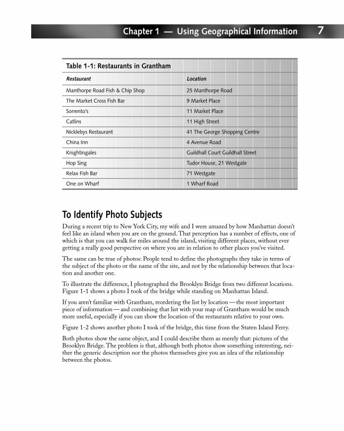
The first rule of survival is to find something to eat, so you do a search on one of the variousbusiness directories on the Internet and find a list of restaurants easily enough. Table 1-1 showsa list of some of Grantham’s restaurants and their addresses.
The list treats the information you’ve gained as simply a list of restaurants and their addresses.To make use of information in this format, you either need to know Grantham and its streetsreally well or you need a map in order to make heads or tails of the addresses. You would thenneed to use both the list and the map to work out in which direction you need to begin walkingand when and where you need to turn left or right.
If you aren’t familiar with Grantham, reordering the list by location — the most importantpiece of information — and combining that list with your map of Grantham would be muchmore useful, especially if you can show the location of the restaurants relative to your own.
05_790095 ch01.qxp 6/12/06 1:30 PM Page 6
7Chapter 1 — Using Geographical Information
Table 1-1: Restaurants in Grantham
Restaurant Location
Manthorpe Road Fish & Chip Shop 25 Manthorpe Road
The Market Cross Fish Bar 9 Market Place
Sorrento’s 11 Market Place
Catlins 11 High Street
Nicklebys Restaurant 41 The George Shopping Centre
China Inn 4 Avenue Road
Knightingales Guildhall Court Guildhall Street
Hop Sing Tudor House, 21 Westgate
Relax Fish Bar 71 Westgate
One on Wharf 1 Wharf Road
To Identify Photo SubjectsDuring a recent trip to New York City, my wife and I were amazed by how Manhattan doesn’tfeel like an island when you are on the ground. That perception has a number of effects, one ofwhich is that you can walk for miles around the island, visiting different places, without evergetting a really good perspective on where you are in relation to other places you’ve visited.
The same can be true of photos: People tend to define the photographs they take in terms ofthe subject of the photo or the name of the site, and not by the relationship between that loca-tion and another one.
To illustrate the difference, I photographed the Brooklyn Bridge from two different locations.Figure 1-1 shows a photo I took of the bridge while standing on Manhattan Island.
If you aren’t familiar with Grantham, reordering the list by location — the most importantpiece of information — and combining that list with your map of Grantham would be muchmore useful, especially if you can show the location of the restaurants relative to your own.
Figure 1-2 shows another photo I took of the bridge, this time from the Staten Island Ferry.
Both photos show the same object, and I could describe them as merely that: pictures of theBrooklyn Bridge. The problem is that, although both photos show something interesting, nei-ther the generic description nor the photos themselves give you an idea of the relationshipbetween the photos.
05_790095 ch01.qxp 6/12/06 1:30 PM Page 7

8 Part I — Basics
FIGURE 1-1: The Brooklyn Bridge from its base.
05_790095 ch01.qxp 6/12/06 1:30 PM Page 8

9Chapter 1 — Using Geographical Information
FIGURE 1-2: The Brooklyn Bridge from the Staten Island Ferry.
The same can be said of any set of photos that show the same subject. For example, photos of aproperty don’t always give you an accurate impression of a house or building because you don’tnecessarily know from where the photo was taken, which direction the photographer was facing,or what the content of the photo is in relation to other photos that might be in the same file.
If you treat the photos as merely a record of your visit and describe them with meaninglessterms (that is, a description of what the photo is, rather than where it is), you lose some of themost valuable information about the photo.
By thinking about photos in geographical terms (where they were taken, the direction you werefacing) and combining this information with a map of the location (in this example,Manhattan), a vacation photo can become more than just a shot of a famous landmark.
To Understand Statistical DataMy wife and I arrived in New York City the weekend that Hurricane Katrina hit the Gulf Coastof the United States. The results of the hurricane were devastating. But hearing the results, oreven seeing the interviews and reports “on the ground” about the effects of the hurricane onNew Orleans and the surrounding areas, wasn’t anywhere near as informative as the satelliteimages of New Orleans, taken before and after the hurricane hit. Through the Google Mapsand Earth service, Google provided the images that showed these differences (see Figure 1-3).
05_790095 ch01.qxp 6/12/06 1:30 PM Page 9

10 Part I — Basics
FIGURE 1-3: New Orleans before and after Hurricane Katrina.
Equally instructive were the maps showing the predicted route and, later, the actual route thatthe hurricane took. As successive hurricanes hit the Gulf Coast of the United States that fall,these maps became a vital method for individuals, companies, and government, emergency, andweather organizations to work out the probable location of landfall.
With a visual representation of the actual or predicted location of the storm, individuals couldeasily identify, at a glance, where the storm would be at a later time. This made the other infor-mation (number of miles off the coast, the towns and cities being affected, and so on) easier tounderstand.
A picture is worth a thousand words, which is why graphs and geographical data are combinedin a variety of situations. Votes in elections, population data, plant and animal areas, even themigration routes and quantities of birds can all be described by marrying map data with thestatistical information.
To Generate Data from MapsWhile my wife and I were in New York City, we did a lot of walking — using the subwaywould have robbed us of the ability to view our surroundings and enjoy the city’s architecture.On one particular day, we walked to Soho, from there to the Brooklyn Bridge, then around thebottom of Manhattan, across to the Staten Island Ferry, back again, and then back up to ourhotel.
05_790095 ch01.qxp 6/12/06 1:30 PM Page 10

11Chapter 1 — Using Geographical Information
In the past, determining how far we’d walked would have been difficult without using a map,retracing our route, and then possibly using a piece of string and some quick math based on themap’s scale to determine the distance. Using a Google Maps application, though, I was able toquickly determine exactly how far we had walked. I generated that data using information I’dgained from the map.
In this case, the translation of information into geographical representations is not what provedto be the most useful — the map data itself, in combination with some data points (the streetsand places we visited), provided me with the information I needed.
Wrapping UpNow you know several ways in which a location can be defined, as well as how important it isto think about information in relation to its geographical worth. To learn how to produceapplications that convert information and portray it in geographical terms, read on!
05_790095 ch01.qxp 6/12/06 1:30 PM Page 11

05_790095 ch01.qxp 6/12/06 1:30 PM Page 12