use of land capability classification system in the surface mining
TRANSCRIPT

2032
USE OF LAND CAPABILITY CLASSIFICATION SYSTEM IN THE
SURFACE MINING CONTROL AND RECLAMATION
ACT OF 1977 (PUBLIC LAW 95-87) 1
H. R. Sinclair, Jr., and Robert R. Dobos2
Abstract. The Surface Mining Control and Reclamation Act of 1977 (Public
Law 95-87) authorized the Secretary of the Interior to implement a regulatory
program to reduce the environmental impacts of coal mining operations. The
Secretary of Interior administers this program through the Office of Surface
Mining Reclamation and Enforcement (OSM) with assistance from state and other
federal agencies as specified in the law. All functions and responsibilities
assigned to USDA by Public Law 95-87 were delegated by the Secretary of
Agriculture to the Chief of USDA-NRCS, except those that relate to the National
Forest Service System Lands and to the USDA-Agriculture Research Service.
This paper briefly presents how the Land Capability Classification System can be
used in the development of rules, regulations, and guidelines for evaluating the
quality of soil reclamation after surface mining for coal. The Land Capability
Classification System can provide for compliance with Public Law 95-87. The
land capability of the reclaimed soils can be compared to the capability of the pre-
mined soils for producing crops.
Additional Key Words: farmland, grandfathering, historically used for cropland,
Land Capability Class, Land Capability Subclass, Land
Capability Unit, Soil Map Unit, soil component.
______________________
1 Poster paper presented at the 7
th International Conference on Acid Rock Drainage (ICARD),
March 26-30, 2006, St. Louis MO. R.I. Barnhisel (ed.) Published by the American Society
of Mining and Reclamation (ASMR), 3134 Montavesta Road, Lexington, KY 40502 2H. Raymond Sinclair, Jr. and Robert R. Dobos are Soil Scientists, National Soil Survey Center,
United States Department of Agriculture, Natural Resources Conservation Service, Federal
Building, Room 152, 100 Centennial Mall North, Lincoln, NE 68508-3866.
7th
International Conference on Acid Rock Drainage, 2006 pp 2032-2043
DOI: 10.21000/JASMR06022032

2033
Introduction
The Surface Mining Control and Reclamation Act of 1977 (P. L. 95-87) authorized the
Secretary of the Interior to implement a regulatory program to reduce the environmental impacts
of mining operations. The Secretary of Interior administers this program through the Office of
Surface Mining Reclamation and Enforcement (OSM) with assistance from state and other
federal agencies as specified in the law. All functions and responsibilities assigned to USDA by
P. L. 95-87 were delegated by the Secretary of Agriculture to the Chief of USDA-NRCS, except
those that relate to the National Forest Service System Lands and to the USDA-Agriculture
Research Service (USDA-SCS, 1983a). Title V of P. L. 95-87 addresses land areas that have not
been surface mined for coal. It describes the reconstruction of a mined soil to recreate soil
conditions prior to mining, and bases the success of reclamation upon the soil’s pre-mined
productivity (30CFR., 2002). The NRCS participates with the State Regulatory Authority (SRA)
on answering technical soil questions during the removal, storage, and reclamation of prime
farmland historically used as cropland (30 CFR, 2002; USDA-SCS, 1983b; Sinclair, 2004).
USDA-NRCS (1999) addresses the activities and conditions requiring specific attention for soil
manipulations associated with reclamation of prime farmland. NRCS assists the SRA and mine
operators in identifying prime farmland and restoring its productivity after mining (30 CFR,
2002a and b). These activities are in cooperation with SRA and with the assistance of other
USDA agencies.
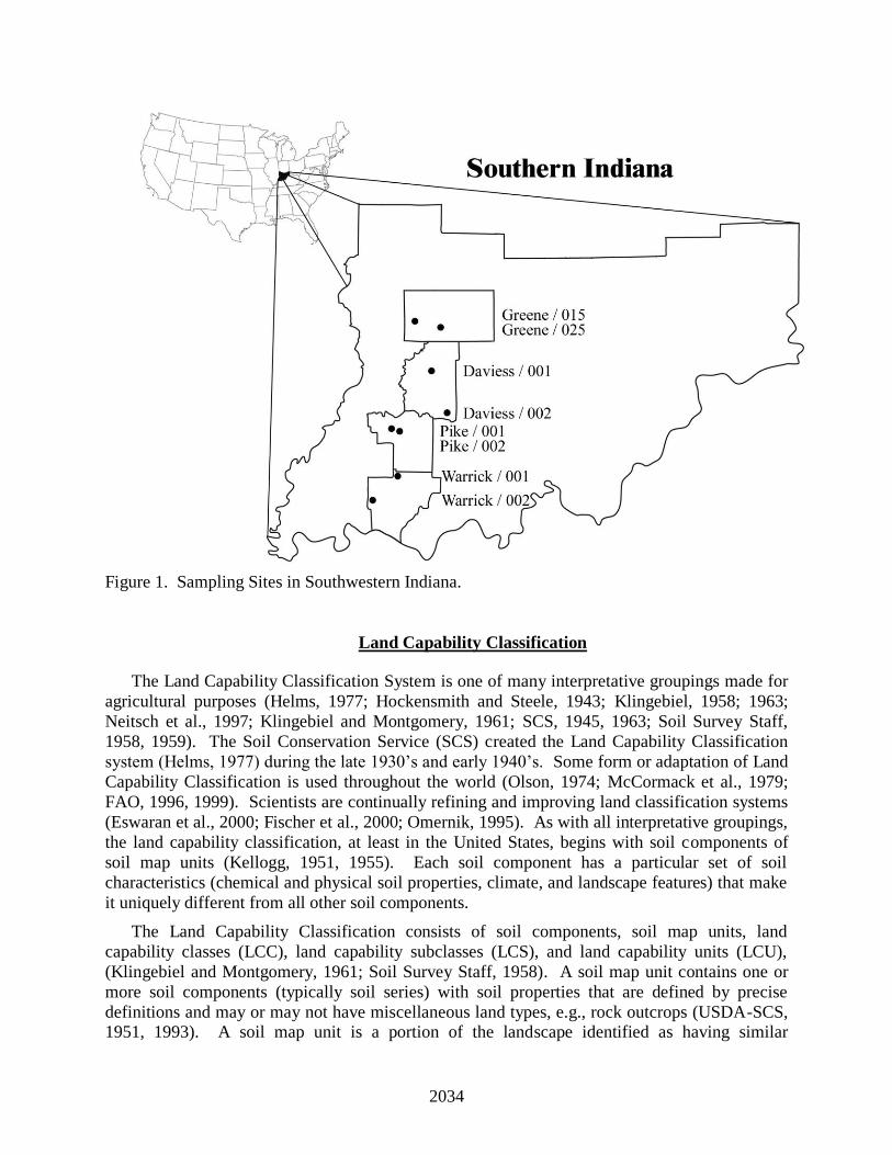
Figure 1 shows the sampling sites used in a study (Sinclair et al., 2004 and 2005) comparing
pre- and post-mining land capability classes for several soils in Indiana. Scraper placement was
used to reclaim all sites except at the Daviess/001 site, where shovel-truck placement was used
during reclamation. The number of years since reclamation is presented in Table 1.
Table 1.The number of years the sites had been reclaimed.
________________________________________________
County/Soil Years
Reclaimed
Daviess/001 14
Daviess/002 6
Greene/015 16
Greene/025 17
Pike/001 12
Pike/002 10
Warrick/001 15
Warrick/002 13
_______________________________________________
2034
Figure 1. Sampling Sites in Southwestern Indiana.
Land Capability Classification
The Land Capability Classification System is one of many interpretative groupings made for
agricultural purposes (Helms, 1977; Hockensmith and Steele, 1943; Klingebiel, 1958; 1963;
Neitsch et al., 1997; Klingebiel and Montgomery, 1961; SCS, 1945, 1963; Soil Survey Staff,
1958, 1959). The Soil Conservation Service (SCS) created the Land Capability Classification
system (Helms, 1977) during the late 1930’s and early 1940’s. Some form or adaptation of Land
Capability Classification is used throughout the world (Olson, 1974; McCormack et al., 1979;
FAO, 1996, 1999). Scientists are continually refining and improving land classification systems
(Eswaran et al., 2000; Fischer et al., 2000; Omernik, 1995). As with all interpretative groupings,
the land capability classification, at least in the United States, begins with soil components of
soil map units (Kellogg, 1951, 1955). Each soil component has a particular set of soil
characteristics (chemical and physical soil properties, climate, and landscape features) that make
it uniquely different from all other soil components.
The Land Capability Classification consists of soil components, soil map units, land
capability classes (LCC), land capability subclasses (LCS), and land capability units (LCU),
(Klingebiel and Montgomery, 1961; Soil Survey Staff, 1958). A soil map unit contains one or
more soil components (typically soil series) with soil properties that are defined by precise
definitions and may or may not have miscellaneous land types, e.g., rock outcrops (USDA-SCS, 1951, 1993). A soil map unit is a portion of the landscape identified as having similar

2035
characteristics and qualities. The LCC are groups of soil map units with the same relative
degrees of hazards or limitations, based on their soil characteristics, for cropland and pasture
uses.
The LCS are groups of LCC’s that have the same major conservation problem, e.g., “e” for
erosion, “w” for excess water, “s” for root-zone limitations, and “c” for climatic limitations. An
LCU is a grouping of one or more LCS’s that have similar potentials and continuing limitations
or hazards (Soil Survey Staff, 1959). The soil map units in an LCU are sufficiently uniform to
(1) produce similar kinds of cultivated crops and pasture plants with similar management
practices, (2) require similar conservation treatment and management under the same kind and
condition of vegetative cover, and (3) have comparable potential productivity. Odell (1950)
explains how the productivity of soils is measured under various environmental conditions. In
addition Land Capability Classification has uses other than for agriculture including land use
planning and national soil/land inventories (Hockensmith, 1948, 1949; Kellogg, 1968;
Klingebiel, 1967; SCS, 1945; Smith, 1983; USDA, 1965 and 2000; USDA-NRCS, 1997).
The land capability classification system (LCC, LCS, and LCU) can be used in the
development of guidelines, particularly for the information shown in table 2, for evaluating the
quality of soil reclamation after surface mining for coal. This information can help meet the
compliance rules and regulations contained in P. L. 95-87 and 30 CFR. The land capability of
the reclaimed soils can be compared to the capability of the pre-mined soils. This will test the
ability of the reclaimed soils to produce crops relative to the original soil. The remainder of this
paper will focus on using LCC to reconstruct a soil so it will meet the requirement in 30 CFR for
productivity thus resulting in bond release.
Land Capability Classification and the Surface Mining Control and Reclamation Act
Table 2 lists the soil characteristics and their text criteria and numerical values that are used
to assign LCC. The major difference in LCC for pre-mined and reclaimed soils (table 3) was
always a result of changes in soil available water capacity (AWC). The importance of AWC in
pre-mined and mined soils are discussed by Doll et al., 1984; Merrill et al.,1985, 1998, 2004;
Omodt, 1975; Suhl, 2003; Soil Survey Division Staff, 1993; Sencindiver and Ammons, 2000;
Fehrenbacher and Snider, 1954; Fehrenbacher and Rust, 1956; Fehrenbacher et al., 1960 and
1967; and Scrivner et al., 1985. Dunker and Barnhisel, 2000 cited McFee et al., 1981 –
“Electrical conductance and water storage capacity were most significantly related to growth
and toxic levels of B, Fe, Mn, and Al decreased growth on some materials.” The AWC is the
volume of water that should be available to plants if the soil, inclusive of rock fragments, were at
field capacity. Field capacity is the amount of water a soil can hold after water has drained by
gravity from the large pores. Reductions in AWC are made in the water difference for
incomplete root utilization of the total soil volume. Fragipans, bulk density, soil strength,
extremely low pH values, high water tables, and other chemical and physical properties can
restrict plant rooting and rooting distribution throughout the soil mass. These soil features are
either used in calculation of AWC or are surrogates to estimate the AWC for both pre-mined and
reclaimed soils. These surrogate properties are important as indicators of plant rooting and
AWC of which soil bulk density and soil strength are very important in determining plant rooting
and AWC. The amount of available water is measured to the expected maximum depth of root
penetration, commonly either 1 or 1.5 m, or a physical or chemical root limitation, whichever is
shallower (Soil Survey Division Staff, 1993).

2036

2037

2038
The field and laboratory data reported by Sinclair et al. (2004b, 2005) support that all
reclaimed soils in this study had less AWC for plant growth than the soils before mining except
for one site (Warrick 002 site). The other soil characteristics listed in Table 2 except AWC
supported the LCC in Table 3 (Sinclair et al., 2004b and Sinclair, 2005). To be more specific,
the reclaimed soils would all be LCC of I or II if the AWC in the reclaimed soils were higher. A
higher AWC would result from a favorable change in bulk density, soil strength, permeability,
and structure for growing commodity crops. High bulk density, high soil strength, low
permeability, and lack of structure (massive, non granular and non blocky) limit the rooting
depth in the reclaimed soils, therefore reducing AWC (O’Neal, 1952; Uhland and O’Neal, 1951;
Schoeneberger et al., 2002; Sinclair et al., 2004b, 2005). High bulk densities and soil strength
are the major physical soil properties that restrict plant rooting depth and rooting distribution
throughout the soil mass, thus reducing the available water capacity to plants (Dunker and
Barnhisel, 2000).
Land Capability Classes I, II, and III are considered suitable for cropland and class IV is
hayland. LCC of V, VI, VII, and VIII are not considered arable, but can be used for permanent
vegetation unless it is a miscellaneous land type. The changes in the land capability classes in
Table 3 are due to lower AWC in the reclaimed soils compared to the pre-mined soils. This
lower AWC in the reclaimed soils would indicate that the reclaimed soils probably would have
lower long-term average yields than the pre-mined soils. Crop production as a measure of prime
farmland reclamation success is explained in 30CFR., 2002. Olson (1992) explains the
difference in methods and procedures used in the 1977 Surface Mining Control and Reclamation
Act and those used by the University of Illinois to determine long term crop yields.
Comments and Conclusion
The Land Capability Classification is one of many interpretative groupings that can be used
to evaluate arable and non arable lands for limitations or hazards for producing commodity crops
using soil characteristics. The Land Capability Classification can be used to compare the
reclaimed soils after surface mining for coal to their pre-mimed condition. The classification
system involves soil components, soil map units, land capability classes (LCC), land capability
subclasses (LCS), and land capability unit (LCU).
Lack of soil structure (massive or single grained), high bulk density, high soil strength, and
slow permeability in subsurface layers limit rooting, thus resulting in lower soil AWC’s for the
reclaimed soils compared to the pre-mined soil condition. Four of the soils before mining had a
LCC of II and after reclamation had a LCC of IV. Three of the soils before mining had a LCC of
I or II and after reclamation had a LCC of III. One of the soils had the same LCC before and
after mining.
The reclamation process used to reconstruct soils after surface mining for coal is
continuingly changing. Reclamation using scraper placement after surface mining for coal is
becoming a thing of the past as the more progressive mining companies are using shovel-truck
replacement of soil (discussions with other people and personal experiences/observations by
author).
The partnership among the coal companies, USDI’s Office of Surface Mining, State
Regulatory Authority, researchers, and NRCS is improving reclamation technology. The new
reclamation technologies being used today by the coal companies to reclaim prime farmland

2039
soils will need to be evaluated by studying their morphological properties and sampling them for
laboratory characterization (experiences and observations by author).
Table 3. Land capability classes (LCC) assigned by Available Water Capacity (AWC) for
reclaimed soils and pre-mined soils (Sinclair et al., 2004b).
County / Soil AWC of Reclaimed Reclaimed Pre-mined
Soils LCC LCC
cm
Daviess/001 10.9 III I
Daviess/002 10.6 III II
Greene/015 6 IV II
Greene/025 6.8 IV II
Pike/001 3.4 IV II
Pike/002 9.9 III II
Warrick/001 6.6 IV II
Warrick/002 16.8 II II
Literature Cited
Doll, E.C., S.D. Merrill, and G.A. Halvorson. 1984. Soil Replacement for Reclamation of
Stripmined Lands in North Dakota. Agricultural Experiment Station Bulletin 514. North
Dakota State University.
Dunker, R.E. and R.I. Barnhisel. 2000. Crop Reclamation. pp. 323-369. In Richard I
Barnhisel, Robert G. Darmody, W. Lee Daniels (ed). Reclamation of Drastically Disturbed
Lands. 2nd
ed. Agron. Mongr. 41. ASA, CSSA, and SSSA, Madison, WI.
Eswaran, H., F.H. Beinroth, and S.M. Virmani. 2000. Resource management domains: a
biophysical unit for assessing and monitoring land quality. Elsevier. Agriculture, Ecosystems
and Environment 81:155-162. http://dx.doi.org/10.1016/S0167-8809(00)00189-4.
FAO. 1996. Agro-ecological zoning. Guidelines. Ed:1 Vol:73.
http://www.fao.org/docrep/W2962E/W2962E00.htm
FAO. 1999. AEZWIN An interactive multiple-criteria analysis tool for land resources appraisal
(with CD-ROM included). World Soil Resources Report - Series 87.
http://www.fao.org/icatalog/inter-e.htm

2040
Fehrenbacher, J.B. and H.J. Snider. 1954. Corn Root Penetration in Muscatine, Elliott, and Cisne
Soils. Soil Sci. 77:281-291. http://dx.doi.org/10.1097/00010694-195404000-00004.
Feherenbacher, J.B. and R.H. Rust. 1956. Corn Root Penetration in Soils Derived from Various
Textures of Wisconsin-Age Glacial Till. Soil Sci. 82:369-378.
http://dx.doi.org/10.1097/00010694-195611000-0000378.
Fehrenbacher, J.B., P.R. Johnson, R.T. Odell, and P.E. Johnson. 1960. Root Penetration and
Development of Some Farm Crops as Related to Soil Physical and Chemical Properties. 7th
Trans. Int. Congr. of Soil Science III:243-252. Madison, WI.
Fehrenbacher, J.B., B. W. Ray, and J.D. Alexander. IL Agric. Exp. Stn. Spring 1967. Root
Development of Corn, Soybeans, Wheat, and Meadow in Some Contrasting Illinois Soils.
Illinois Research 9:3-5. Illinois Agricultural Experiment Station. Urbana, IL.
Fischer, G., H.T. van Velthuizen, F.O. Nachtergaele. 2000. Global Agro-Ecological Zones
Assessment: Methodology and Results. IIASA - International Institute for Applied System
Analysis and FAO - Food and Agriculture Organization of the United Nations.
http://www.iiasa.ac.at/docs/Admin/PUB/Catalog/PUB_ONLINE.html
Helms, D. 1977. “Land Capability Classification: The U.S. Experience.” In Dan H. Yaalon
and S. Berkowicz (ed.) History of Soil Science: International Perspectives. Advances in
GeoEcology 29:159-175. CATENA VERLAG. Aimegass, D-35447 Reiskirchen, Germany.
Hockensmith, J.G. and J.G. Steele. 1943. Classifying Land for Conservation Farming. p. 1-45.
Farmers Bulletin No. 1953. USDA, Washington, DC.
Hockensmith, R.D. 1948. The Use of Land-Capability Maps for Rural Real Estate Assessment.
p. 152-157. In Ronald B. Welch (ed.) Proceeding of the Forty-First Annual Conference on
Taxation, held under the auspices of the National Tax Association. Denver, Colorado.
October 4-7, 1948.
Hockensmith, R.D. 1949. Classification of Land According to Its Capability as a Basis for a
Soil Conservation Program. p. 450-465. Proceedings of the Inter-American Conference on
Conservation of Renewable Natural Resources. Denver, Colorado. September 7-20, 1948.
Kellogg, C.E. 1951. Soil and Land Classification. Journal of Farm Economics. 33 (4): 499-513.
http://dx.doi.org/10.2307/1233560.
Kellogg, C.E. 1955. Soil Surveys in Modern Farming. Jour. Soil and Water Cons.10:271-275.
Kellogg, C.E. 1968. A forward Look at Soil Use. Jour. Soil and Water Cons. 23 (4):127-130.
Klingebiel, A.A. 1958. Soil Survey Interpretation - Capability Groupings. Soil Sci. Soc. Amer.
Proc. 22:160-163.
Klingebiel, A.A. and P.H. Montgomery. 1961. Land-Capability Classification. USDA-SCS
Agric. Handb. 210. U.S. Gov. Print. Office, Washington, DC.
Klingebiel, A.A. 1963. Land Classification for Use in Planning. p. 399-407. In Agriculture
Yearbook. U.S. Department of Agriculture, Washington, DC.
Klingebiel, A.A. 1958. Soil Survey Interpretation - Capability Groupings. Soil Sci. Soc. Amer.
Proc. 22:160-163. http://dx.doi.org/10.2136/sssaj1958.03615995002200020019x.

2041
McFee, W.W., W.R. Byrnes, and J.G. Stockton. 1981. Characteristics of Coal Mine Overburden
Important to Plant Growth. Journal of Environmental Quality 10:300-308.
http://dx.doi.org/10.2134/jeq1981.00472425001000030009x.
McCormack, D.E., A.W. Moore, and J. Dumanski. 1979? A Review of Soil Information
Systems in Canada, the United States, and Australia. p. 143-156. In (name of publication is
unknown).
Merrill, S.D., S.J. Smith, and J.F. Power. 1998. Subsoil Characteristics and Landscape Position
Affect Productivity of Reconstructed Mine Soils.. Soil Science Society of America Journal
49:196-202. http://dx.doi.org/10.2136/sssaj1985.03615995004900010039x.
Merrill, S.D., R.E. Ries, and J.F. Power. 1985. Effects of Disturbed Soil Thickness on Soil Water
Use and Movement under Perennial Grass. Soil Science Society of America Journal 62:263-
271 http://dx.doi.org/10.2136/sssaj1998.03615995006200010034x
Merrill, S.D., D.L. Tanaka, J.M. Krupinsky, and R.E. Ries. 2004. Water Use and Depletion by
Diverse Crop Species on Haplustoll Soil in the Northern Great Plains. Journal of Soil and
Water Conservation 59:176-183.
Neitsch, C.L., M.L. Golden, L.R. Hossner. 1997. Land Capability Classification. pp. 141-151.
In Jon E. Brandt, Proceedings, 1997 Annual National Meeting of the American Society for
Surface Mining and Reclamation, Austin, TX, May 10-15.
Odell, R.T. 1950. Measurements of the Productivity of Soils under Various Environmental
Conditions. Agron. Jour. 42:282-292.
http://dx.doi.org/10.2134/agronj1950.00021962004200060004x.
Olson, G.W. 1974. Interpretative Land Classification in English-Speaking Countries (a working
paper on some of the systems in current use and some of their adaptations). p. 1-25.
Condensed from a document prepared by Dr. G.W. Olson, Cornell University, NY. In
Edouard Saouma (ed.) Approaches to Land Classification. Soils Bulletin 22. FAO. Rome.
Olson, K. R. 1992. Assessment of Reclaimed Farmland Disturbed by Surface Mining in Illinois.
pp. 173-176. In R.E. Dunker, et al. (ed.) Proc. of the 1992 Natl. Symp. On Prime Farmland
Reclamation. Dep. of Agron., Univ. of IL, Urbana, IL.
Omernik, J.M. 1995. Ecoregions: A spatial framework for environmental management. p. 49-
62. In W.S. Davis, and T.P. Simon, (eds.) Biological assessment and criteria: tools for
water resource planning and decision making. Lewis Publishers. Boca Raton, FL.
Omodt, H.W., F.W. Shroer, and D.D. Patterson. 1975. Agricultural Experiment Station Bulletin
492. North Dakota State University.
O'Neal, A.M. 1952. A key for Evaluating Soil Permeability by Means of Certain Field Clues.
Soil Science Society of American Proceeding 16:312-315.
http://dx.doi.org/10.2136/sssaj1952.03615995001600030024x.
P.L. 95-87. 1977. Surface Mining Control and Reclamation Act of 1977. 30 CFR. 2002a.
Submission of State Programs. Mineral Resources. Code of Federal Regulations (CFR) Part
701.5.

2042
Schoeneberger, P.J., D.A. Wysocki, E.C. Benham, and W.D. Broderson. 2002. Field Book for
Describing and Sampling Soils, Version 2.0. USDA-NRCS National Soil Survey Center.
Lincoln, NE.
Scrivner, C.L., B.L. Conkling, and P.G. Koieng. 1985. Soil Productivity Indices and Soil
Properties for Farm-Field Sites in Missouri. Agricultural Experiment Station. University of
Missouri-Columbia.
Sencindiver, J.C. and J.T. Ammons. 2000. Minesoil Genesis and Classification. pp. 595-613.
In Richard I Barnhisel, Robert G. Darmody, W. Lee Daniels (ed). Reclamation of
Drastically Disturbed Lands. 2nd
ed. Agron. Mongr. 41. ASA, CSSA, and SSSA, Madison,
WI.
Sinclair, H.R. 2004, USDA-NRCS's Role for Soils Information in the Surface Mining Control
and Reclamation Act of 1977 (Public Law 95-87, Proceedings America Society of Mining
and Reclamation, 2004 pp 1700-1727 http://dx.doi.org/10.21000/JASMR0401700
Sinclair, H. R., Jr., K. M. McWilliams, S. L. Wade, and G. R. Struben. 2004, Characterization of
Reclaimed Soils in Southwestern Indiana after Surface Mining for Coal, 2004, Proceedings
America Society of Mining and Reclamation, 2004 pp 1674-1699
Sinclair, H. R., Jr., K. M. McWilliams, S. L. Wade, and G. R. Struben. 2004, Characterization of
Reclaimed Soils in Southwestern Indiana after Surface Mining for Coal, 2004, Proceedings
America Society of Mining and Reclamation, 2004 pp 1674-1699
http://dx.doi.org/10.21000/JASMR0401674
Sinclair, H. R., Jr., K. M. McWilliams, C.A. Seybold, R.B. Grossman, S.L. Baird, and T. G.
Reinsch. 2005. Characterization of Reclaimed Soils in Southwestern Indiana after Surface
Mining for Coal, Part II. National Meeting of the American Society of Mining and
Reclamation, June 20-23, 2005. Published by ASMR, 3134 Montavesta Rd., Lexington, KY
40502.
Smith, Donald F. 1983. Options for evaluation of prime farmland reclamation success (soil
survey versus crop production as a measure of soil productivity). In: Proceedings 1983
Symposium on Surface Mining, Hydrology, Sedimentology, Reclamation, November 28 -
December 2, 1983 [University of Kentucky, Lexington, KY], pages 489-494.
Soil Conservation Service. 1945. Soil and Water Conservation Needs Estimate for the United
States. Soil Conservation Service, Washington, DC.
Soil Conservation Service. 1963. Know the Capability of Your Land. p. 1-25. USDA-NRCS,
Washington, DC.
Soil Survey Staff. May 19, 1958. Land Capability Classification. Soils Memorandum SCS-22.
Soil Conservation Service, Washington, DC.
Soil Survey Staff. August 11, 1959. Land Capability Subclass. Soils Memorandum SCS-30.
Soil Conversation Service, Washington, DC.
30CFR. 2002. Submission of State Programs. Mineral Resources. Code of Federal Regulations
(CFR) Part 823.
Suhl, S.E. 2003. Soil Survey of Fulton County, Illinois. U.S. Department of Agriculture,
Natural Resources Conservation Service.

2043
Uhland, R. E. and A. M, O’Neal. 1951. Soil Permeability Determinations for Use in Soil and
Water Conservation. SCS-Technical Paper- 101. U.S. Department of Agriculture. Soil
Conservation Service. Washington, D.C. 36 pages, illustrated.
U.S. Department of Agriculture, Natural Resources Conservation Service, 1997. 1997 National
Resources Inventory (Revised December 2000). Washington, D.C.
U.S. Department of Agriculture, Natural Resources Conservation Service. 1999. Mining
Specifications for Prime Farmland. Federal Register. Volume 64. No. 124. Tuesday, June
29, 1999/Notice.
U.S. Department of Agriculture. 1965. Soil and Water Conservation Needs - A National
Inventory. p. 1-94. Misc. Publication No. 971. Washington, DC.
U.S. Department of Agriculture, Soil Conservation Service. 1983a. Program-Surface Mining
Control and Reclamation Act of 1977. Land Treatment Program-Surface Mining Control
and Reclamation Act of 1977 (P. L. 95-87). National Instructions, title 300, Second Issue,
Part 300. Washington, D.C.
U.S. Department of Agriculture, Soil Conservation Service. 1983b. Restoration of Prime
Farmlands Mined for Coal. Land Treatment Program-Surface Mining Control and
Reclamation Act of 1977 (P. L. 95-87). National Instructions, title 300, Part 301.
Washington, D.C.
U.S. Department of Agriculture. Soil Conservation Service. Soil Survey Staff. 1951. Soil
Survey Manual. U.S. Department of Agriculture Handbook. 18, U.S. Government Printing
Office. Washington, D.C. 503 pages, illustrated.
U.S. Department of Agriculture. Soil Conservation Service. Soil Survey Division Staff. 1993.
Soil Survey Manual. U.S. Department of Agriculture Handbook. 18, U.S. Government
Printing Office. Washington, D.C. 437 pages, illustrated.
U.S. Department of Agriculture. 2000. Summary Report: 1997 National Resources Inventory
(revised December 2000), Natural Resources Conservation Service, Washington, DC, and
Statistical Laboratory, Iowa State University, Ames, Iowa, 89 pages.