use of engineering properties to identify multiple...
TRANSCRIPT
!"
Use of Engineering Properties to Identify Multiple Glacial Advances in
New York City’s Subsurface
Cheryl J. Moss, Mueser Rutledge Consulting Engineers, 14 Penn Plaza, New York, NY
10122 ([email protected])
INTRODUCTION
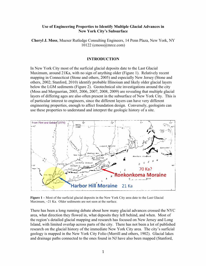
In New York City most of the surficial glacial deposits date to the Last Glacial
Maximum, around 21Ka, with no sign of anything older (Figure 1). Relatively recent
mapping in Connecticut (Stone and others, 2005) and especially New Jersey (Stone and
others, 2002; Stanford, 2010) identify probable Illinoisan and likely older glacial layers
below the LGM sediments (Figure 2). Geotechnical site investigations around the city
(Moss and Merguerian, 2005, 2006, 2007, 2008, 2009) are revealing that multiple glacial
layers of differing ages are also often present in the subsurface of New York City. This is
of particular interest to engineers, since the different layers can have very different
engineering properties, enough to affect foundation design. Conversely, geologists can
use these properties to understand and interpret the geologic history of a site.
Figure 1 – Most of the surficial glacial deposits in the New York City area date to the Last Glacial
Maximum, ~21 Ka. Older sediments are not seen at the surface.
There has been a long running debate about how many glacial advances crossed the NYC
area, what direction they flowed in, what deposits they left behind, and when. Most of
the region’s detailed glacial mapping and research has focused on New Jersey and Long
Island, with limited overlap across parts of the city. There has not been a lot of published
research on the glacial history of the immediate New York City area. The city’s surficial
geology is mapped in the New York City Folio (Merrill and others, 1902). Glacial lakes
and drainage paths connected to the ones found in NJ have also been mapped (Stanford,

#"
2010; Stanford and Harper, 1991). Subsurface strata are described and contoured in
Queens and Brooklyn (Soren, 1978; Buxton and Shernoff, 1999), but deposits above the
Sangamon age Gardiner’s Clay are all grouped together as “upper Pleistocene deposits”
with little interpretation. Research by Sanders and Merguerian (1991, 1994, 1998;
Merguerian and Sanders, 1996; Merguerian, 2003) is the most city specific and detailed
overall, and describes a sequence of events that provides a good explanation for the many
different deposits seen in New York City.
Figure 2 – Map showing the limits of the Late Wisconsinan, Illinoisan and pre-Illinoisan glaciations in
New Jersey, and LGM glacial flowlines. In eastern NJ, ice flow followed the valleys and was partially
confined behind the Palisades Ridge. Some ice, however, flowed over the Palisades and SE across NYC.
Consequently, much of NYC’s glacial deposits originated in NJ. Adapted from Stanford, 2010.
$"
REGIONAL MAPPING
The Quaternary geologic map of Connecticut and Long Island Sound Basin (Stone and
others, 2005) identifies older till, probably of Illinoisan age, below younger till deposited
during the late Wisconsinan. The Surficial geologic map of northern New Jersey (Stone
and others, 2002) also describes older till below younger till, and Stanford (2010) maps
older glacial deposits south of the Wisconsinan terminal moraine. The older till, of
Illinoisan and probably pre-Illinoisan age, is weathered, in some cases with the oldest
clasts completely decomposed.
The New Jersey mapping indicates much of NJ’s glacial flow came from the N to NNE
and in eastern NJ followed the lowlands, further scouring out valleys between basaltic
ridges. The Palisades ridge, a sill of diabase along the western bank of the Hudson River,
acted as a partial barrier that largely separated the various NJ deposits from their
counterparts in NY. Consequently, the glacial sediments on either side of the Palisades
and their engineering properties are often quite different (Moss and Merguerian, 2005).
However, there was some glacial flow over the Palisades and across NYC. As a result, a
large percentage of the NYC glacial deposits originated in NJ. NJ mapping also
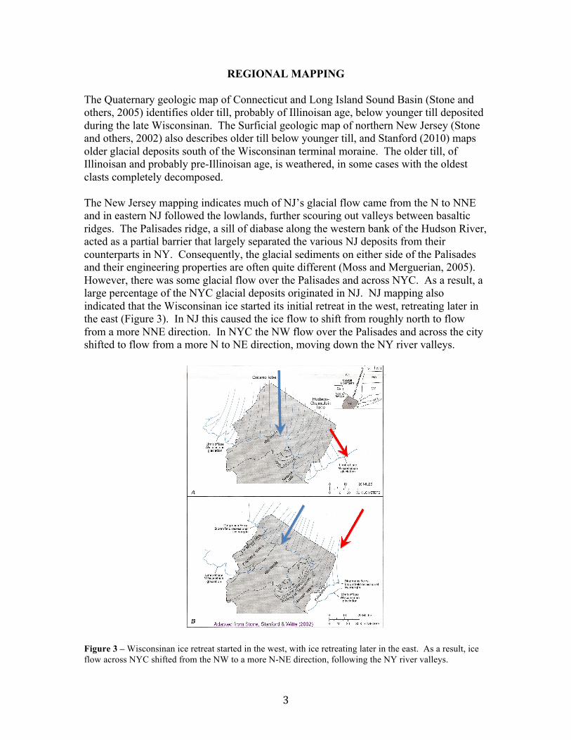
indicated that the Wisconsinan ice started its initial retreat in the west, retreating later in
the east (Figure 3). In NJ this caused the ice flow to shift from roughly north to flow
from a more NNE direction. In NYC the NW flow over the Palisades and across the city
shifted to flow from a more N to NE direction, moving down the NY river valleys.
Figure 3 – Wisconsinan ice retreat started in the west, with ice retreating later in the east. As a result, ice
flow across NYC shifted from the NW to a more N-NE direction, following the NY river valleys.

%"
Along the western side of the Hudson in NJ, the rock is largely a distinctive mix of
Mesozoic redbeds and basaltic igneous rocks, along with some zones of serpentinite
(Figure 4). Across the Hudson in NY, the rock switches dramatically to generally
micaceous metamorphics such as schist and gneiss, along with some marble. In eastern
Queens and Brooklyn the rock is overlain by Cretaceous clay. Changes in the direction
of glacial flow pick up these differences in the underlying bedrock.
Figure 4 – LGM Glacial flow over the Palisades (black arrows) brought distinctive rock from NJ across the
city. Recessional shift in flow to a more N-NE direction (red arrow) carried micaceous rock and
Cretaceous clay over portions of the city.
NEW YORK CITY SUBSURFACE
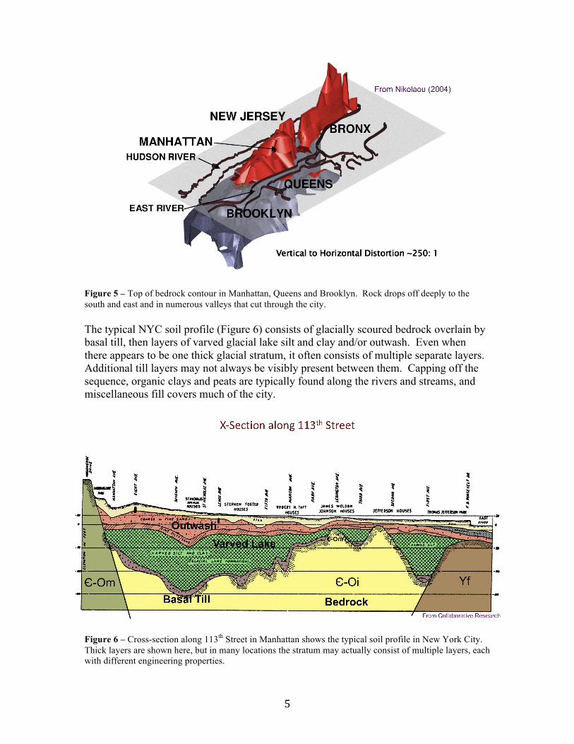
In NYC the bedrock drops off quickly to the south and east (Figure 5), and the city is cut
by numerous valleys, some at least 300 feet deep. Valleys commonly trend NW, likely
following scoured out fault zones, or NNE following the regional trend of folds and
lithologic contacts. Geotechnical site investigations indicate there are multiple layers of
glacial sediments present in the subsurface, particularly in the protection of the valleys.
&"
Figure 5 – Top of bedrock contour in Manhattan, Queens and Brooklyn. Rock drops off deeply to the
south and east and in numerous valleys that cut through the city.
The typical NYC soil profile (Figure 6) consists of glacially scoured bedrock overlain by
basal till, then layers of varved glacial lake silt and clay and/or outwash. Even when
there appears to be one thick glacial stratum, it often consists of multiple separate layers.
Additional till layers may not always be visibly present between them. Capping off the
sequence, organic clays and peats are typically found along the rivers and streams, and
miscellaneous fill covers much of the city.
Figure 6 – Cross-section along 113
th Street in Manhattan shows the typical soil profile in New York City.
Thick layers are shown here, but in many locations the stratum may actually consist of multiple layers, each
with different engineering properties.

'"
ENGINEERING PROPERTIES
Engineers routinely test the properties of a soil to assess its behavior, analyzing density,
strength, permeability, liquifaction and settlement, amongst other qualities. Geologists
can use the same data to analyze the site’s history. Differences in the engineering
properties of the deposits can be used to separate and interpret the strata (Figure 7).
Consolidation tests may give specific values for previous glacial loads on the soil. SPT
blow counts can also provide information about the soil’s previous loading history. In
particular, a sudden increase in SPT blows below a certain elevation across a site
indicates the strata below may have been glacially loaded, while the layers above were
not. Intervening till layers are not always visibly present, but are often found at that
elevation nearby. These property differences are commonly seen in NYC, with changes
often occurring over relatively short distances vertically and/or laterally.
Figure 7 – Schematic cross-section through multiple glacial strata, and their engineering properties. While
much of NYC’s bedrock has been scoured clean by glacial action, in some sheltered locations younger
glaciations flowed over and buried the older deposits, rather than eroding them and the underlying rock
away. This has happened repeatedly in some areas, leaving behind multiple glacial layers. The presence of
weathered bedrock +/or clasts is an indication of at least relative age. SPT blowcounts and
preconsolidation values can provide specific information about the loading history of the different strata.
Changes in landform and lithology mark different events +/or a change in flow direction. Changes in
seismic properties can also identify changes in strata and possibly weathering and age.
Since much of the NYC bedrock surface has been scoured by glacial ice, there’s
generally not a lot of chemically weathered rock present, though exceptions exist.
Particularly in the shelter of valleys, older deposits are often over-ridden by newer glacial
advances rather than being scoured away completely by them. In turn, the older
sediments protect the underlying bedrock from erosion. If the soil has been in place long
enough to weather and/or allow the underlying bedrock to decompose, the degree of
weathering may provide information on the relative age of the stratum.
Changes in the seismic properties of the soil may also identify layers of differing age or
with a different level of weathering and/or cementation.
Weathered Bedrock
Scoured Bedrock
Weathered Clasts
SPT Blowcounts and Pc Values Can Identify Glacially Loaded Strata
("
Since NYC was in the terminal zone of multiple glaciations, minor shifts in stratigraphy
may reflect short-term events within a glaciation. However, significant changes in
landform or lithology are likely produced by different glacial events or changes in glacial
flow.
FEATURED SITES IN BRIEF
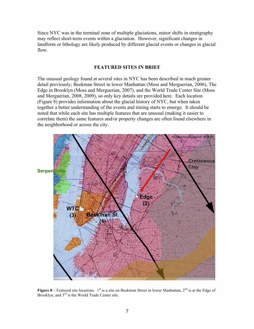
The unusual geology found at several sites in NYC has been described in much greater
detail previously; Beekman Street in lower Manhattan (Moss and Merguerian, 2006), The
Edge in Brooklyn (Moss and Merguerian, 2007), and the World Trade Center Site (Moss
and Merguerian, 2008, 2009), so only key details are provided here. Each location
(Figure 8) provides information about the glacial history of NYC, but when taken
together a better understanding of the events and timing starts to emerge. It should be
noted that while each site has multiple features that are unusual (making it easier to
correlate them) the same features and/or property changes are often found elsewhere in
the neighborhood or across the city.
Figure 8 – Featured site locations. 1
st is a site on Beekman Street in lower Manhattan, 2
nd is at the Edge of
Brooklyn, and 3rd
is the World Trade Center site.

)"
Beekman Street – Bedrock Valley in Lower Manhattan
A site in SE Manhattan on Beekman Street (Figure 9) lies above a bedrock valley filled
with deposits from what appears to be at least 4 different glacial advances. The site has
schistose bedrock overlain with thin zones of decomposed rock. Above this is a thin
layer of locally derived till. This is topped with a sequence of outwash sand, then glacial
lake varves, outwash, varves, then a darker and more micaceous outwash overlain by fill.
Pockets of till containing decomposed schist are found at the base of the lower varved
layer and till pockets with NJ serpentinite are at the base of the upper varves. Across the
site SPT blow counts increase dramatically below the upper varves/till, and in places
even more so below the lower varves/till. Stratified drift below the lower till has cross-
hole seismic shear wave velocities more typical of weak rock rather than soil, possibly
from weak cementing in an older, more weathered stratum. The pockets of decomposed
bedrock below and till above could be the source of the cement.
Figure 9 – Cross-section along the southern end of the Beekman Street site. The strata provide evidence of
at least 4 different glacial advances. The lower outwash (1), showing signs of weathering +/or cementation,
is likely much older than the overlying strata. Although the till at the bottom of varved layers (2) and (3) is
thin and discontinuous, the change in engineering properties and lithology indicates glacial loading during
different advances. The darker, more micaceous, less dense outwash at the surface (4) reflects a shift of
glacial flow over micaceous rock, but the site itself was south of the areas that were glacially loaded.

*"
The Edge of Brooklyn
Repeated glacial advances generally scoured the NYC bedrock clean, but NW Brooklyn
(Figure 10) has unusually thick decomposed rock above gneissic bedrock. This is
overlain by an odd, dense clayey silt layer derived from decomposed rock, which was
possibly deposited in a glacial lake. Above this lie thin till pockets, then more typical
glacial lake sediments, then a thick, dense clay till that contains Cretaceous clay found
only to the NE. This is overlain by a mixed glacial ablation deposit the color of till
derived from rocks found to the north and NE. The upper till layers end at, and just south
of, the site, indicating they were deposited by a less extensive glacial advance.
Figure 10 – Cross-section along the northern end of the Edge site in Brooklyn and photos of typical soil.
The site has evidence of at least 2 different glacial advances. The extreme degree of bedrock weathering
suggests that the lowest strata are associated with a much older event. The presence of upper till layers that
reflect source material found only to the north and NE of the site indicate that during LGM recession the
ice flow over NYC shifted direction to come from the NE, mirroring the shift seen in NJ. The upper till
layers end just to the south of the site (which is NE of the Beekman Street site), marking the extent of the
limited readvance.

!+"
The World Trade Center Site – Lower Manhattan
At the WTC site (Figure 11) plunge pools and potholes were scoured 40 feet deep into
the bedrock and filled with an incredibly dense till native to NJ, indicating a glaciation
from the NW. A silt layer 2/3 of the way up in the till contained a tree branch 14
C dated
at 49,500 (+3050/-2205) BP. The plungepools were carved in an event (likely glacial)
prior to the deposition of till during a glaciation older than LGM.
Figure 11 – World Trade Center site in lower
Manhattan. A – 40’ deep scoured plungepools.
B – Filled with glacial till. C – Piece of wood
dated at 49,500 BP. D – Found 2/3 of the way
up, in a silt layer. E –Located within the dense
till native to NJ, indicating flow from the NW.
A
B
C
D
E
!!"
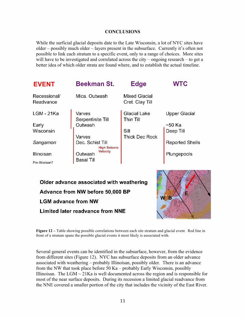
CONCLUSIONS
While the surficial glacial deposits date to the Late Wisconsin, a lot of NYC sites have
older – possibly much older – layers present in the subsurface. Currently it’s often not
possible to link each stratum to a specific event, only to a range of choices. More sites
will have to be investigated and correlated across the city – ongoing research – to get a
better idea of which older strata are found where, and to establish the actual timeline.
Figure 12 – Table showing possible correlations between each site stratum and glacial event. Red line in
front of a stratum spans the possible glacial events it most likely is associated with.
Several general events can be identified in the subsurface, however, from the evidence
from different sites (Figure 12). NYC has subsurface deposits from an older advance
associated with weathering – probably Illinoisan, possibly older. There is an advance
from the NW that took place before 50 Ka – probably Early Wisconsin, possibly
Illinoisan. The LGM ~ 21Ka is well documented across the region and is responsible for
most of the near surface deposits. During its recession a limited glacial readvance from
the NNE covered a smaller portion of the city that includes the vicinity of the East River.
EVENT

!#"
ACKNOWLEDGEMENTS
"
,"-./01"0234"5."56783"564"079":57;;<"48=2844>:"781"?7>584>:".;"@/4:4>"A/5041=4"
B.8:/0528="C8=2844>:";.>"5642>"7::2:578D4".E4>"564"F47>:"28"=7564>28="28;.>G752.8<"
?>.E2128="1757"781";.>".9572828="D02485"?4>G2::2.8"5."?/902:6H"","-./01"70:."0234"5."
56783"564"D02485:";.>"700.-28="/:"5."?/902:6"?>.?>2457>F"28;.>G752.8".9572841";>.G"
5642>"?>.I4D5:H ,"-./01"70:."0234"5."56783"B67>04:"@4>=/4>278";.>"62:"640?"781"
48D./>7=4G485".E4>"564"F47>:"5."?/>:/4">4:47>D6".8"564:4"781".564>":254:H""
REFERENCES
Baskerville, C.A., 1992, Bedrock and engineering geologic maps of Bronx County and parts of New York
and Queens Counties, New York: U.S. Geological Survey, Miscellaneous Investigations Series Map I-
2003, scale 1:24000.
Baskerville, C.A., 1994, Bedrock and engineering geologic maps of New York County and parts of Kings
and Queens Counties, New York, and parts of Bergen and Hudson Counties, New Jersey: U.S. Geological
Survey, Miscellaneous Investigations Series Map I-2306, scale 1:24000.
Buxton, Herbert; and Shernoff, Peter, 1999, Ground-water resources of Kings and Queens Counties, Long
Island, New York: U.S. Geological Survey Water-Supply Paper 2498, 113p.
Merguerian, Charles, 2003, The Narrows flood – Post-Woodfordian meltwater breach of the Narrows
channel, NYC: in Hanson, G. N., chm., Tenth Annual Conference on Geology of Long Island and
Metropolitan New York, 12 April 2003, State University of New York at Stony Brook, NY, Long Island
Geologists Program with Abstracts, 13 p.
Merguerian, Charles; and Sanders, J. E., 1996, Glacial geology of Long Island: Guidebook for On-The-
Rocks 1996 Fieldtrip Series, Trip 39, 01 + 02 June 1996, Section of Geological Sciences, New York
Academy of Sciences, 130 p.
Merrill, F. J. H.; Darton, N. H.; Hollick, Arthur; Salisbury, R. D.; Dodge, R. E.; Willis, Bailey; and
Pressey, H. A., 1902, Description of the New York City district: United States Geological Survey Geologic
Atlas of the United States, New York City Folio, No. 83, 19 p.
Moss, Cheryl J.; and Merguerian, Charles, 2005, Loading patterns in varved Pleistocene sediment in the
NYC area: in Hanson, G. N., chm., Twelfth Annual Conference on Geology of Long Island and
Metropolitan New York, 16 April 2005, State University of New York at Stony Brook, NY, Long Island
Geologists Program with Abstracts.
Moss, Cheryl J.; and Merguerian, Charles, 2006, Evidence for multiple glacial advances and ice loading
from a buried valley in southern Manhattan: in Hanson, G. N., chm., Thirteenth Annual Conference on
Geology of Long Island and Metropolitan New York, 22 April 2006, State University of New York at
Stony Brook, NY, Long Island Geologists Program with Abstracts, 16p.
Moss, Cheryl J.; and Merguerian, Charles, 2007, Different and Distinct – Implications of Unusual Glacial
Strata in BrooklynJ"28"K78:.8<"LH"MH<"D6GH<"N./>544856"O88/70"B.8;4>48D4".8"L4.0.=F".;"P.8=",:0781"
781"@45>.?.02578"M4-"Q.>3<"!%"O?>20"#++(<"R5754"S82E4>:25F".;"M4-"Q.>3"75"R5.8F"T>..3<"MQ<"P.8="
,:0781"L4.0.=2:5:"U>.=>7G"-256"O9:5>7D5:<"!*"?H"
Moss, Cheryl J.; and Merguerian, Charles, 2008, Bedrock control of a boulder-filled valley under the
World Trade Center site: in Hanson, G. N., chm., Fifteenth Annual Conference on Geology of Long Island

!$"
and Metropolitan New York, 12 April 2008, State University of New York at Stony Brook, NY, Long
Island Geologists Program with Abstracts, 13 p.
Moss, Cheryl J.; and Merguerian, Charles, 2009, 50 Ka Till-Filled Pleistocene Plunge Pools and Potholes
Found Beneath the World Trade Center Site, New York, NY: in Hanson, G. N., chm., Sixteenth Annual
Conference on Geology of Long Island and Metropolitan New York, 28 March 2009, State University of
New York at Stony Brook, NY, Long Island Geologists Program with Abstracts, 19 p.
Nikolaou, Sissy, 2004, Local Geology of New York City and its Effect on Seismic Ground Motions, in
Proceedings: Fifth International Conference on Case Histories in Geotechnical Engineering, New York,
NY, April 13-17, 2004, 14 p.
Sanders, J. E.; and Merguerian, Charles, 1991, Pleistocene tills in the New York City region: new evidence
confirms multiple (three and possibly four) glaciations from two directions (NNE to SSE and NW to SE)
(abs.): Geological Society of America, Abstracts with Programs, v. 23, no. 1, p. 123.
Sanders, J. E.; and Merguerian, Charles, 1994, Glacial geology of the New York City region, p. 93-200 in
Benimoff, A. I., ed., The geology of Staten Island, New York: Geological Association of New Jersey
Annual Meeting, 11th, Somerset, NJ, 14-15 October 1994, Field guide and proceedings, 296 p.
Sanders, John E.; and Merguerian, Charles, 1998, Classification of Pleistocene deposits, New York City
and vicinity – Fuller (1914) revived and revised: p. 130-143 in Hanson, G. N., chm., Geology of Long
Island and metropolitan New York, 18 April 1998, State University of New York at Stony Brook, NY,
Long Island Geologists Program with Abstracts, 161 p.
Soren, Julian; 1978, Subsurface geology and paleogeography of Queens County, Long Island, New York:
U. S. Geological Survey Water-Resources Investigations 77-34 Open File Report, 17p.
Stanford, Scott D., 2010, Glacial Geology and Geomorphology of the Passaic, Hackensack, and Lower
Hudson Valleys, New Jersey and New York, p. 47-84 in Benimoff, A. I., ed., New York State Geological
Association 82nd
Annual Meeting Field Trip Guidebook, Staten Island, NY, 24-26 September 2010, 190 p.
Stanford, S. D.; and Harper, D. P, 1991, Glacial lakes of the lower Passaic, Hackensack, and lower Hudson
valleys, New Jersey and New York, Northeastern Geology, vol. 13, no. 4, p. 271-286.
Stone, B.D.; Stanford, S.D.; and Witte, R.W., 2002, Surficial geologic map of northern New Jersey: U.S.
Geological Survey, Miscellaneous Investigations Series Map I-2540-C, scale 1:100000.
Stone, J.R.; Schafer, J.P.; London, E.H.; DiGiacomo-Cohen, M.L.; Lewis, R.S.; and Thompson, W.B.,
2005, Quaternary geologic map of Connecticut and Long Island Sound Basin: U.S. Geological Survey,
Scientific Investigations Map SIM-2784, scale 1:125000.