usace extreme precipitation data applications, methods ... · gage data, (ascii, dss) outputs dss...
TRANSCRIPT
US Army Corps of Engineers BUILDING STRONG®
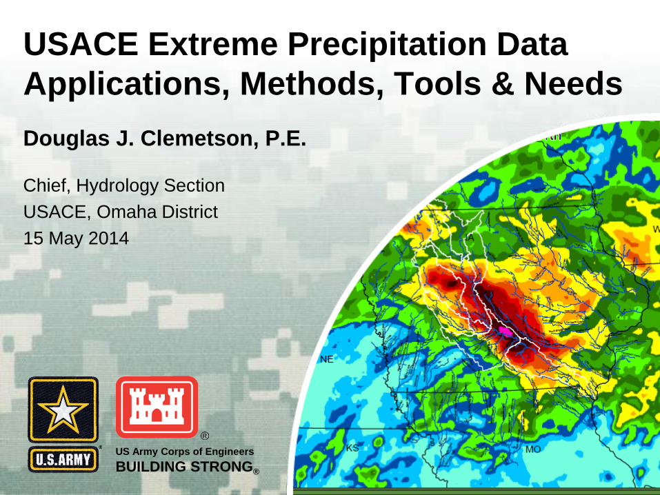
Douglas J. Clemetson, P.E.
USACE Extreme Precipitation Data Applications, Methods, Tools & Needs
Chief, Hydrology Section USACE, Omaha District 15 May 2014

BUILDING STRONG®
USACE Extreme Storm Team
Chandra Pathak, Proponent, HQ David Margo, Hydraulic Engineer, RMC Matt Fleming, Hydraulic Engineer, HEC Larry Schick, Meteorologist, NWS Angela Duren, Hydraulic Engineer, SPK Marian Baker, Meteorologist, NWK Simeon Benson, Hydraulic Engineer, SWF Kent Walker, Hydraulic Engineer, RMC Hayden Smith, Hydraulic Engineer, RMC Doug Clemetson, Hydraulic Engineer, NWO Chuck McWilliams, Meteorologist, NWO George Hayes, Geographer, NWO

BUILDING STRONG®
USACE Extreme Storm Data Needs Dam Safety Program
► Site-Specific PMP Studies ► Hydrometeorological Reports (HMR’s) updates ► HMR Tools
Levee Safety Program ► Update Standard Project Storm Criteria ► Precip-Frequency (NOAA-14, TP40, NOAA II)
Extreme Storm Database ► Extreme Storm Data Archiving/Retrieval ► Analysis of Recent Extreme Storm Events ► Linked with HEC-HMS, HEC-MetVue, etc.

BUILDING STRONG®
Computation of Areal Reduction Factors Calibration of Hydrologic Models Stochastic Extreme Flood Modeling (SEFM) Atmospheric Modeling of Extreme
Precipitation
Misc Extreme Storm Data Needs
4

BUILDING STRONG®
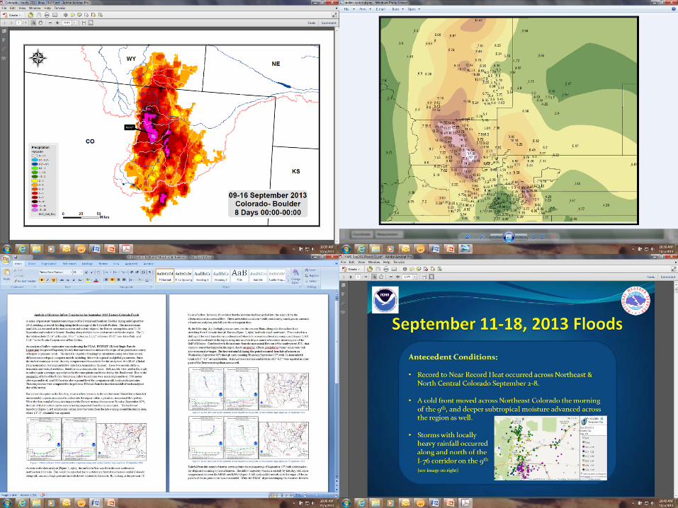
Current Extreme Storm Applications Extreme Storm Database Process Radar Imagery Digitize Historic Isohyetal Maps
Site Specific PMP Studies Completed: Moose Cr, Bluestone, Whittier Narrows In progress: Martis Creek, Ft Peck, Garrison, Kajaki
HEC-MetVue Tool Process storms (DAD, Isohyetal, gridded precip) Rotate, Transpose, Maximize, link with DSS/HMS HMR51/52, HMR55A plugins
HMR57 Tool Atmospheric Modeling

BUILDING STRONG®
Common Database shared with all federal and state agencies, academia, private consultants Historic and Future Extreme Storms Depth Area Duration, Isohyetal maps, mass
rainfall curves, meteorological characteristics Interfaced with Hydrologic Models, tools, etc
Extreme Storm Database
6

BUILDING STRONG®
Extreme Storm Catalog

BUILDING STRONG®
Bucket Survey Form Original Isohyetal Map
Digitized Isohyetal Map GIS for Transposition Studies
Data Archiving and Analysis System

BUILDING STRONG® 9
Stage III MPE
ABRFC May 1993-Dec 2004 Jun 2003-Sep 2005
APRFC Jul 2002-Sep 2005
CBRFC Sep 1996-Mar 2002 Feb 2002-Sep 2005
CNRFC Sep 1996-Jan 2005 May 2003-Sep 2005
LMRFC Apr 1996-Aug 2003 Aug 2003-Sep 2005
MARFC Oct 1995-Dec 2001 Oct 1999-Sep 2005
MBRFC Nov 1994-Jun 2003 Jan 2003-Sep 2005
NCRFC Dec 1994-Apr 2002 Feb 2002-Sep 2005
NERFC Feb 1996-Aug 2002 Aug 2002-Sep 2005
NWRFC Jan 1996-Nov 2002 Nov 2002-Sep 2005
OHRFC Dec 1995-Jun 2003 Dec 2001-Sep 2005
SERFC Dec 1995-Sep 2002 Jan 2002-Sep 2005
Radar Data can be downloaded from the NWS http://dipper.nws.noaa.gov/hdsb/data/nexrad/nexrad.html
Radar Estimates of Precipitation

BUILDING STRONG®
Radar Image .xmrg format gridLoadXMRG
Gage Data NCDC gageInterp
DSS file Gridded Format
dss2ascGrid
ArcGIS Shape files
geo-RAS RAS mapper Depth Area
Duration Curves
Storm Animation
DSSVue HEC-HMS
Zonal Histogram Raster Calculator
Maximum Precip Regional PMF Prob
Digitize Isohyetal Maps

BUILDING STRONG®

BUILDING STRONG®

BUILDING STRONG®

BUILDING STRONG®
BUILDING STRONG®

BUILDING STRONG®
Data Sources
US Storm Rainfall (1882-1973) Bucket Surveys (COE, USBR, NWS) NOAA COOP Observations (1753-2014) NWS Radar Estimates (1993-2014) CoCoRaHS (1998-2014) Local & Regional Precip Networks (NERain, SD-AWDN, NDAWN, DOT, ALERT, etc)
BUILDING STRONG®
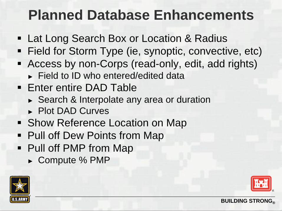
Planned Database Enhancements Lat Long Search Box or Location & Radius Field for Storm Type (ie, synoptic, convective, etc) Access by non-Corps (read-only, edit, add rights)
► Field to ID who entered/edited data Enter entire DAD Table
► Search & Interpolate any area or duration ► Plot DAD Curves
Show Reference Location on Map Pull off Dew Points from Map Pull off PMP from Map
► Compute % PMP

BUILDING STRONG®
http://www.weather.gov/oh/hdsc/studies/images/20080513_PMP_Map_r.png
HMR Regional Coverage Location of USACE Dams
USACE Site Specific PMP Studies
- Locations of USACE Site Specific PMP Studies
BUILDING STRONG®
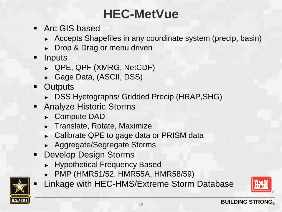
Arc GIS based ► Accepts Shapefiles in any coordinate system (precip, basin) ► Drop & Drag or menu driven
Inputs ► QPE, QPF (XMRG, NetCDF) ► Gage Data, (ASCII, DSS)
Outputs ► DSS Hyetographs/ Gridded Precip (HRAP,SHG)
Analyze Historic Storms ► Compute DAD ► Translate, Rotate, Maximize ► Calibrate QPE to gage data or PRISM data ► Aggregate/Segregate Storms
Develop Design Storms ► Hypothetical Frequency Based ► PMP (HMR51/52, HMR55A, HMR58/59)
Linkage with HEC-HMS/Extreme Storm Database
HEC-MetVue
19

BUILDING STRONG®
HEC-MetVue
20

BUILDING STRONG®
HEC-MetVue
21
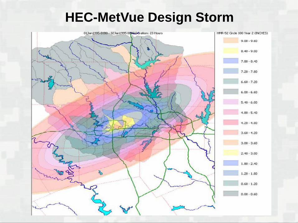
HEC-MetVue Design Storm

BUILDING STRONG®
Pacific Northwest Region (HMR57) Developed by AMEC for MMC ArcGIS plugin Input basin shapefile Computes basin average All-Season PMP at
2000 meter grids Seasonal adjustments and PMP for each month Depth-Duration for each subregion, subregion
weights and aerial adjusted PMP for durations of 1, 6, 24, 48, 72 hour
Temporal distributions for 6-hr intervals and creates hyetographs in DSS file
HMR57 Tool
23

BUILDING STRONG®
Atmospheric Modeling
24

BUILDING STRONG® Source : THE OREGONIAN/Bruce Ely The Chehalis River, Dec 200

BUILDING STRONG®
Questions/Comments?