usaace regulation 115-1
TRANSCRIPT
USAACE Reg 115-1 • 7 September 2016
1
*USAACE Reg 115-1
DEPARTMENT OF THE ARMY
HEADQUARTERS, UNITED STATES ARMY AVIATION CENTER OF EXCELLENCE
FORT RUCKER, ALABAMA 36362-5105
USAACE Regulation 7 September 2016
No. 115-1
Climatic, Hydrological, and Topographic Services
U.S. ARMY AVIATION CENTER OF EXCELLENCE (USAACE) WEATHER SUPPORT
Paragraph Page
INTRODUCTION
FRWXOPS Mission .................................................................... 1-1 3
FRWXOPS Overview ................................................................. 1-2 3
Contact Information .................................................................... 1-3 3
FRWXOPS Responsibilities ....................................................... 1-4 3
Release of Weather Information to Non-DOD Agencies/
Individuals ................................................................................. 1-5 3
Release of Weather Information to DOD Agencies/
Individuals ................................................................................. 1-6 3
2. OBSERVING PRODUCTS AND SERVICES
Overview ..................................................................................... 2-1 4
Surface Observation Products ..................................................... 2-2 4
Surface Observation Equipment ................................................. 2-3 4
Surface Observation Dissemination ............................................ 2-4 6
Surface Observation Code .......................................................... 2-5 6
Observing Limitations................................................................. 2-6 9
Pilot Reports (PIREPs)................................................................ 2-7 11
3. FORECAST PRODUCTS AND SERVICES
Overview ..................................................................................... 3-1 12
Forecast Products ........................................................................ 3-2 12
Forecast Product Dissemination to Aircrews .............................. 3-3 14
Resource Protection Products ..................................................... 3-4 16
Other Forecast Services .............................................................. 3-5 18
Forecast Product Limitations ...................................................... 3-6 19
4. RECIPROCAL SUPPORT AND RESPONSIBILITIES
FRWXOPS Roles and Responsibilities ...................................... 4-1 20
Fort Rucker Activity Requirements ............................................ 4-2 20
___________________________________________________
*This regulation supersedes Fort Rucker Reg 115-1, 3 Apr 15.

USAACE Reg 115-1 • 7 September 2016
2
Page
APPENDIX A. Weather Station Duty Priorities .................................................. 25
B. SPECI Criteria (Cairns AAF) ..................................................... 26
C. FMQ-19 Augmentation Parameters ............................................ 28
D. Weather Watch/Warning/Advisory Criteria ............................... 30
E. Breakdown of the DD Form 175-1 ............................................. 35
F. Breakdown of the MEF ............................................................... 38
G. MEF Forecast Areas Defined ...................................................... 40
H. MEF Specification/Amendment Criteria .................................... 42
I. USAACE Weather Support Requirements/Customer Actions ... 44
J. Customer Mission-Limiting Weather Thresholds ....................... 46
USAACE Reg 115-1 • 7 September 2016
3
CHAPTER 1
FORT RUCKER WEATHER OPERATIONS (FRWXOPS) INTRODUCTION
1-1. FRWXOPS MISSION. FRWXOPS provides meteorological support to Fort Rucker, the USAACE,
and other assigned and tenant units at Fort Rucker listed in this regulation.
1-2. FRWXOPS OVERVIEW. The official military organization of FRWXOPS is Operating Location
(OL)-C of the 18th Weather Squadron (18 WS) at Fort Bragg, NC. OL-C, 18 WS is a team of
meteorological technicians and electronic technicians located at Cairns Army Airfield (AAF). Locally,
FRWXOPS is aligned under the Air Division, USAACE G3.
1-3. CONTACT INFORMATION. FRWXOPS is located in building 30101D Wallace Street,
Fort Rucker, AL 36362. The telephone numbers are DSN 558-8385/8397 (commercial
334-255-8385/8397). The fax number is DSN 558-8521 (commercial 334-255-8521).
1-4. FRWXOPS RESPONSIBILITIES. FRWXOPS’s primary responsibilities are to provide tailored
mission planning and execution weather services for USAACE aviation flight training and to augment the
automated observing sensor as needed. These services are outlined in chapters 2 and 3. Reciprocal
support and responsibilities are outlined in chapter 4. All weather services provided by FRWXOPS are
accomplished in accordance with (IAW) the duty priorities listed in appendix A. The maintenance work
center maintains the Doppler weather radar located in Echo, AL, in addition to the automated weather
sensors at Cairns AAF, Hanchey Army Heliport (AHP), and Lowe AHP. The general responsibilities of
the Air Force and Army with regard to weather support are outlined in Army Regulation (AR) 115-10,
Weather Support and Services for the U.S. Army, 10 September 2015, and AR 5-25, Army Weather
Functional Activities, 2 July 2013.
1-5. RELEASE OF WEATHER INFORMATION TO NON-DOD AGENCIES/INDIVIDUALS.
FRWXOPS will not release weather information to non-Department of Defense (DOD) agencies or
individuals without prior coordination with the Fort Rucker Installation Operations Center (IOC) for
severe weather events or the Public Affairs Office (PAO) for routine weather information. The IOC or
PAO will provide written evidence of coordination before any release of information.
1-6. RELEASE OF WEATHER INFORMATION TO DOD AGENCIES/INDIVIDUALS.
FRWXOPS is required to release a significant event report in the event of a weather-related aircraft
mishap (Class A, B, or C) or upon occurrence of a severe weather event where damage has occurred to
the post. These reports are prepared and disseminated to the appropriate agencies as soon as possible. In
case of a severe weather event, the weather summary will be sent to the IOC. All reports will be sent to
the 18 WS, Air Combat Command (ACC), 26th Operational Weather Squadron (26 OWS), and USAACE
G3. Basic climatology for Cairns AAF, Hanchey AHP, and Lowe AHP is available on the FRWXOPS
homepage at http://www.rucker.army.mil/6weather/index.htm. Any other request for data should be
made to FRWXOPS, in writing or electronically, with a minimum of 3 hours notice.
USAACE Reg 115-1 • 7 September 2016
4
CHAPTER 2
OBSERVING PRODUCTS AND SERVICES
2-1. OVERVIEW. An FMQ-19 automated meteorological observing system at Cairns AAF
automatically collects and disseminates weather observations. The Cairns AAF observation is the official
observation for the Class D (control tower is operational) or Class E (control tower is not operational)
airspace as described in Fort Rucker Regulation (Reg) 95-2, Directory of Aviation Training Facilities and
Procedures, 27 April 2015. Additional weather sensors are located at Hanchey AHP, Lowe AHP, Shell
AHP, and Molinelli Range.
a. FRWXOPS. Weather technicians are available to augment the FMQ-19, IAW Air Force Manual
(AFMAN) 15-111, Surface Weather Observations, 27 February 2013, incorporating through change 2, 21
January 2016, from 0100L Monday through 0100L Saturday (excluding federal holidays). During all
other hours, a weather technician is on call and will be available to augment the FMQ-19 automated
capability when recalled to implement severe weather action procedures (SWAP) described in paragraph
3-4f. When the automated sensor requires augmentation, a basic weather watch (BWW) is conducted
IAW AFMAN 15-111. A BWW means that weather personnel will recheck weather conditions at
intervals not to exceed 20 minutes since the last observation or check to determine the need for a SPECI
observation when certain criteria are occurring or forecast to occur within 1 hour. FRWXOPS also
provides “eyes forward” feedback to the 26 OWS as part of a Fort Rucker weather support partnership.
b. Cooperative Weather Watch (CWW). FRWXOPS has established a CWW with the air traffic
control (ATC) towers at Troy Municipal Airport (MAP) and all basefields and stagefields. ATC
personnel will notify the technician when they observe significant weather conditions that differ from
those reported in official observations, and the technician will incorporate that information into local
flight briefings. Pilot reports (PIREPs) are another crucial element of the CWW (see paragraph 2-7).
FRWXOPS will reevaluate weather conditions whenever a reliable source reports weather that differs
from the last observation to determine if a new observation is required and if automated weather sensors
require troubleshooting. The CWW is detailed in paragraph 4-2c.
2-2. SURFACE OBSERVATION PRODUCTS. The FMQ-19 provides METAR and SPECI weather
observations IAW the criteria and guidelines in AFMAN 15-111. METAR observations are disseminated
at approximately: 58 past each hour. SPECI observations are disseminated whenever significant weather
changes occur (see appendix B for SPECI criteria).
2-3. SURFACE OBSERVATION EQUIPMENT. FRWXOPS uses the FMQ-19 automated observing
system to provide observing services to the Fort Rucker area. Additionally, there are several automated
surface observing systems (ASOSs) and two tactical meteorological observing systems-permanent
(TMOS-Ps) in the local flying area that provide surface observations.
a. Fixed Meteorological Instrumentation. Electronic technicians maintain the instrumentation and
displays of all fixed meteorological equipment; however, there may be instances when various Fort
Rucker agencies must assist in repairing equipment when an outage involves aspects that are beyond the
responsibility and capability of the technicians (i.e., communication or power lines).
USAACE Reg 115-1 • 7 September 2016
5
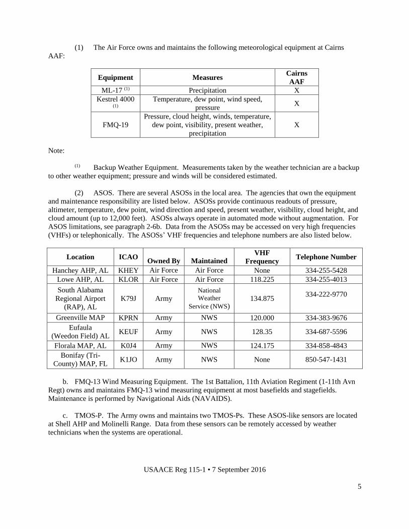
(1) The Air Force owns and maintains the following meteorological equipment at Cairns
AAF:
Equipment Measures Cairns
AAF
ML-17 (1) Precipitation X
Kestrel 4000 (1)
Temperature, dew point, wind speed,
pressure X
FMQ-19
Pressure, cloud height, winds, temperature,
dew point, visibility, present weather,
precipitation
X
Note:
(1) Backup Weather Equipment. Measurements taken by the weather technician are a backup
to other weather equipment; pressure and winds will be considered estimated.
(2) ASOS. There are several ASOSs in the local area. The agencies that own the equipment
and maintenance responsibility are listed below. ASOSs provide continuous readouts of pressure,
altimeter, temperature, dew point, wind direction and speed, present weather, visibility, cloud height, and
cloud amount (up to 12,000 feet). ASOSs always operate in automated mode without augmentation. For
ASOS limitations, see paragraph 2-6b. Data from the ASOSs may be accessed on very high frequencies
(VHFs) or telephonically. The ASOSs’ VHF frequencies and telephone numbers are also listed below.
Location ICAO
Owned By
Maintained
By
VHF
Frequency Telephone Number
Hanchey AHP, AL KHEY Air Force Air Force None 334-255-5428
Lowe AHP, AL KLOR Air Force Air Force 118.225 334-255-4013
South Alabama
Regional Airport
(RAP), AL
K79J Army National
Weather
Service (NWS) 134.875
334-222-9770
Greenville MAP
AL KPRN Army NWS 120.000 334-383-9676
Eufaula
(Weedon Field) AL KEUF Army NWS 128.35 334-687-5596
Florala MAP, AL K0J4 Army NWS 124.175 334-858-4843
Bonifay (Tri-
County) MAP, FL K1JO Army NWS None 850-547-1431
b. FMQ-13 Wind Measuring Equipment. The 1st Battalion, 11th Aviation Regiment (1-11th Avn
Regt) owns and maintains FMQ-13 wind measuring equipment at most basefields and stagefields.
Maintenance is performed by Navigational Aids (NAVAIDS).
c. TMOS-P. The Army owns and maintains two TMOS-Ps. These ASOS-like sensors are located
at Shell AHP and Molinelli Range. Data from these sensors can be remotely accessed by weather
technicians when the systems are operational.
USAACE Reg 115-1 • 7 September 2016
6
d. The priority for Air Force-owned equipment maintenance/restoral is as follows:
(1) Radar.
(2) FMQ-19.
(3) ASOS.
NOTE: In fall 2016, the FMQ-23 will replace the ASOSs at Hanchey AHP and Lowe AHP. At a time
yet to be determined, an FMQ-23 will replace the TMOS-P at Shell AHP, and an ASOS will replace the
TMOS-P at Molinelli Forward Arming and Refueling Point (FARP).
2-4. SURFACE OBSERVATION DISSEMINATION. Surface observations are disseminated locally
and long line. Procedures vary at each location and are described below.
a. Local Dissemination. The primary means for agencies to receive the Cairns AAF observation is
through the Joint Environmental Toolkit (JET) via the Army Airfield Automation System (AAAS). For
non-ATC customers, there are secure and non-secure hyperlinks on the FRWXOPS homepage. The JET,
via the AAAS, provides local and area observations, forecasts, and weather watches, warnings, and
advisories to ATC agencies at Cairns AAF (Army radar approach control [ARAC], HUB Radio, and
tower) and the towers at Hanchey AHP, Lowe AHP, and Shell AHP. If the JET is not working, weather
observations will be accessed by ATC agencies using the JET ATC Portal, which is linked from the
FRWXOPS web page. When the local area network (LAN) and the JET are both inoperative, Cairns
weather technicians will relay observations to the ARAC and HUB along with Cairns AAF, Hanchey
AHP, Lowe AHP, and Shell AHP control towers telephonically using the red weather phone.
b. Long Line Dissemination. IAW Air Force directives, FRWXOPS technicians augment the
FMQ-19 observations (when required) and long line dissemination is accomplished via the JET. In the
event of a JET outage, observations will be transmitted long line via the Air Force Weather Web Service
(AFW-WEBS). In the event of an LAN outage, the observation will be transmitted by another weather
station or OWS as prescribed in AFMAN 15-111.
c. Aircrews with a VHF Radio or telephone may access real-time ASOS weather observation data
at area locations with an ASOS (see paragraph 2-3a). Systems are generally not augmented and should be
used with caution. As stated in Fort Rucker Reg 95-2, the official observation for Fort Rucker basefields
is the Cairns AAF observation.
2-5. SURFACE OBSERVATION CODE. Official surface weather observation abbreviations and
codes are documented in AFMAN 15-111. Examples of a long line METAR, JET Automated Sensor
Display, and JET ATC Portal follow below.
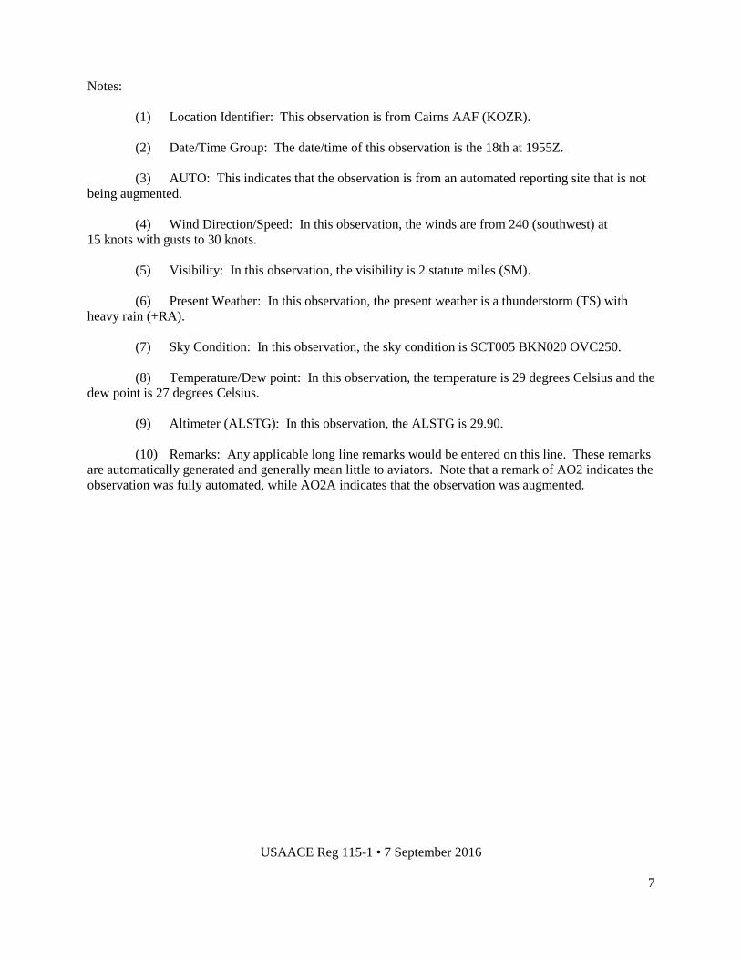
a. Example of a Long Line METAR Observation:
KOZR (1) 181955Z (2) AUTO (3) 24015G30KT (4) 2SM (5) +TSRA (6) SCT005 BKN020 OVC250
(7) 29/27 (8) A2990 (9) RMK AO2 SLP195 T01950092 10196 20105 58011 (10)
USAACE Reg 115-1 • 7 September 2016
7
Notes:
(1) Location Identifier: This observation is from Cairns AAF (KOZR).
(2) Date/Time Group: The date/time of this observation is the 18th at 1955Z.
(3) AUTO: This indicates that the observation is from an automated reporting site that is not
being augmented.
(4) Wind Direction/Speed: In this observation, the winds are from 240 (southwest) at
15 knots with gusts to 30 knots.
(5) Visibility: In this observation, the visibility is 2 statute miles (SM).
(6) Present Weather: In this observation, the present weather is a thunderstorm (TS) with
heavy rain (+RA).
(7) Sky Condition: In this observation, the sky condition is SCT005 BKN020 OVC250.
(8) Temperature/Dew point: In this observation, the temperature is 29 degrees Celsius and the
dew point is 27 degrees Celsius.
(9) Altimeter (ALSTG): In this observation, the ALSTG is 29.90.
(10) Remarks: Any applicable long line remarks would be entered on this line. These remarks
are automatically generated and generally mean little to aviators. Note that a remark of AO2 indicates the
observation was fully automated, while AO2A indicates that the observation was augmented.
USAACE Reg 115-1 • 7 September 2016
8
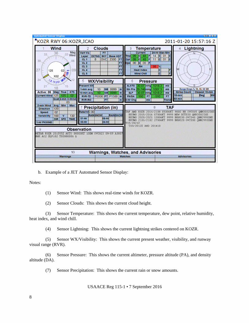
b. Example of a JET Automated Sensor Display:
Notes:
(1) Sensor Wind: This shows real-time winds for KOZR.
(2) Sensor Clouds: This shows the current cloud height.
(3) Sensor Temperature: This shows the current temperature, dew point, relative humidity,
heat index, and wind chill.
(4) Sensor Lightning: This shows the current lightning strikes centered on KOZR.
(5) Sensor WX/Visibility: This shows the current present weather, visibility, and runway
visual range (RVR).
(6) Sensor Pressure: This shows the current altimeter, pressure altitude (PA), and density
altitude (DA).
(7) Sensor Precipitation: This shows the current rain or snow amounts.

USAACE Reg 115-1 • 7 September 2016
9
(8) TAF: This shows the current terminal aerodrome forecast (TAF) for KOZR.
(9) Observation: This shows the current official observation for KOZR.
(10) Warnings, Watches, and Advisories: This shows all warnings, watches, and advisories in
effect for KOZR.
c. Example of the JET ATC Portal:
Notes:
(1) Active runway.
(2) Current winds.
(3) Current altimeter. Note that the altimeter only updates upon receipt of a METAR or
SPECI observation.
(4) RVR, current observation, and active watches, warnings, and advisories.
2-6. OBSERVING LIMITATIONS. The official point of observation at Cairns is the FMQ-19 sensor.
Buildings located at Cairns AAF limit the technician’s ability to take complete representative weather
observations when augmenting the FMQ-19.
a. FRWXOPS Limitations.
(1) The backup observation point is located approximately 30 feet off the southeast corner of
building 30101. From this vantage, the Cairns technician does not have a full 360 degree view of the
airfield. Buildings obstruct the technician’s view of the aerodrome from the southwest through the
1
4
2 3

USAACE Reg 115-1 • 7 September 2016
10
northwest. This limits the technician’s ability to accurately determine prevailing visibility when backing
up the FMQ-19.
(2) Emergency evacuation of the weather station temporarily disrupts observing and
forecasting services. Technicians relocate to the alternate operating location (AOL): a location
with a Class A telephone, a computer with a LAN connection, and a view of the airfield (normally
building 30311, the FLATIRON facility). Observing and forecasting services will be available at the
AOL. The telephone number at the AOL is DSN 558-8157 (commercial 334-255-8157). While
operating from the AOL, backup equipment may be used to record the observation.
(3) Pilot to metro service (PMSV) and the weather information frequency (WIF) are subject to
the limitations inherent in the use of VHFs and ultra-high frequencies (UHFs). Pilots in the local area
may not be able to reach the FRWXOPS technicians via PMSV due to various circumstances that prevent
the signal from reaching the radio tower. See paragraph 3-5 for the PMSV frequency and backup
procedures.
b. General Limitations of the ASOS/TMOS-P.
(1) Cloud height and coverage are determined by a laser beam ceilometer and dependent on
what is directly above the sensor. The ASOS/TMOS-P attempts to determine sky condition but may
provide an incorrect cloud coverage amount if clouds are stationary or moving very slowly. Additionally,
the ASOS/TMOS-P systems cannot determine cloud height above 12,000 feet.
(2) Visibility is determined using a forward scatter visibility meter; ASOS/TMOS-P reported
values may be highly variable and not representative for the entire airfield.
(3) The freezing rain sensor does not report occurrence until ice has accumulated to
≥ 0.01 inch. Aircraft operations may be affected before the ASOS/TMOS-P reports the occurrence of
freezing rain (i.e., icing).
(4) An ASOS/TMOS-P may not detect all thunderstorms or hail occurrences. An
ASOS/TMOS-P cannot detect virga (precipitation not reaching the ground), sector visibility, tower
visibility, or tornadoes.
c. General Limitations of the FMQ-19. As with any automated system, the FMQ-19 has inherent
weaknesses. However, FRWXOPS has developed procedures to mitigate any weaknesses of the system.
(1) Cloud height and coverage are determined by a laser beam ceilometer, which looks at the
small portion of the atmosphere directly above the sensor. Algorithms use time averaging and weighting
in order to determine the sky condition. This sensor-derived sky condition is considered functionally
equivalent to a manually-generated sky condition; the sensor samples the atmosphere directly above the
sensor and the algorithms calculate the sky condition which simulates that of the entire celestial dome.
The FMQ-19 measures cloud heights between 100 feet and 25,000 feet.
(2) Visibility is determined at the sensor group, so it may not always be representative of the
entire airfield. Furthermore, the FMQ-19 cannot report visibility less than 1/4SM. All reportable
visibility values less than 1/4SM are reported as “M1/4SM.”
USAACE Reg 115-1 • 7 September 2016
11
(3) The FMQ-19 may not detect all thunderstorms and lightning and cannot report
thunderstorm and lightning remarks. Furthermore, the system cannot detect hail, virga, tower visibility,
volcanic ash, cloud types, or tornadoes/funnel clouds/waterspouts.
(4) Due to the characteristics of the algorithms, the FMQ-19 may be slow to respond and
report accurate sky condition, visibility, and present weather during periods of rapidly changing weather
conditions.
d. Other Equipment Limitations.
(1) Due to the location of the TMOS-P at Molinelli Range, the reported winds are sometimes
too high because of channeling effects. Note: The TMOS-P at Molinelli Range was logged out (inop) on
21 March 2016.
(2) For unknown reasons, the reported winds from the Shell AHP TMOS-P are sometimes too
high. Note: The TMOS-P at Shell AHP was logged out on 08 March 2016 (winds).
(3) Because the FMQ-13 at Runkle Stagefield is 70 feet high, the surface wind speeds are
generally lower than the sensor-reported values.
(4) The ASOS at Troy MAP is located at the end of the runway rather than the center, so the
winds are not always representative.
2-7. PILOT REPORTS (PIREPs). The local training area is approximately 32,000 square miles and is
a data-sparse region in which weather can vary widely over short distances. PIREPs are an extremely
important source of weather information provided by aircrews operating in the local area.
a. Criteria. FRWXOPS disseminates all PIREPs received.
b. PIREP Format and Dissemination. At a minimum, a PIREP must contain location, time,
altitude, type of aircraft, and at least one weather element such as winds, temperature, icing, turbulence,
low level wind shear (LLWS), visibility, or present weather in order to be disseminated. However, any
reports of significant weather elements are useful and important to weather technicians. PIREPs may be
reported to the weather station via PMSV Radio or relayed to the weather station through ATC agencies.
Technicians also include PIREPs, as appropriate, in flight weather briefings.

USAACE Reg 115-1 • 7 September 2016
12
CHAPTER 3
FORECAST PRODUCTS AND SERVICES
3-1. OVERVIEW. Forecasting support is provided by the Air Force and organized in tiers to serve
various levels of military organizations and operations. The 26 OWS, located at Barksdale Air Force
Base (AFB) in LA, and is at the operational level focusing on meteorology and the production of weather
products for the southeastern portion of the U.S. FRWXOPS partners with the 26 OWS to produce
weather products for Fort Rucker, but also tailors these products into decision-quality weather
information focused on the mission needs of operational customers at Fort Rucker.
a. Onsite forecasting services from FRWXOPS are available from 0100L Monday through
0100L Saturday (excluding federal holidays). The 110th Aviation Brigade (110th AB) will inform
FRWXOPS of any weekend flying not later than 1600L by Thursday of each week, and a forecaster will
be scheduled for overtime. Weather services will be provided by the 26 OWS whenever onsite
forecasting services are not available.
(1) A weather technician is on call during non-duty hours and prepared to respond when
recalled to implement SWAP described in paragraph 3-4f. Contact information will be provided to the
26 OWS to notify the on-call severe weather manager whenever a weather watch or warning is issued for
Fort Rucker.
(2) Should onsite forecasting services not be available for aviation support, customers should
call the 26 OWS for flight weather briefings (DSN 331-2651/2652/2653).
(3) For any other onsite forecasting support including major outdoor events (e.g., Freedom
Fest) that are outside normal hours of operation, a written request should be made to FRWXOPS at least
14 calendar days in advance so overtime support can be coordinated.
b. FRWXOPS produces various forecasts to assist mission planning, training operations,
and resource protection. FRWXOPS is responsible for mission execution forecasts (MEFs) and
Department of Defense (DD) Form 175-1 (Flight Weather Briefings) for flights originating from Cairns
AAF. FRWXOPS provides flight weather information to authorized aircrew members and pilots upon
request. Flight weather briefing products are produced for display on the FRWXOPS homepage.
FLATIRON search and rescue crews are supported on non-training missions as a priority service.
c. The 26 OWS produces the TAF for Cairns AAF, in addition to regional scale weather forecasts
and analysis for the southeastern U.S. The 26 OWS, in conjunction with FRWXOPS, is responsible for
resource protection in the form of weather watches, warnings, and advisories. FRWXOPS collaborates
with the 26 OWS during the production of all products for Fort Rucker. The 26 OWS will continue these
services when FRWXOPS forecasting services are not available, along with flight weather briefing
support. In the event that the 26 OWS is unable to perform any of these services, FRWXOPS will act as a
backup to 26 OWS. FRWXOPS provides “eyes forward” for the 26 OWS.
3-2. FORECAST PRODUCTS. The MEF and DD Form 175-1 are issued at the beginning of each
flying period and valid until the end of that period. See paragraph 3-3b for issue times and valid times for
each flying period. These products are primarily disseminated via the Fort Rucker LAN on the
FRWXOPS homepage. In the event of a LAN outage, the MEF will be emailed or faxed to each
Operations Section. Expect delays when the MEF must be faxed to multiple customers.

USAACE Reg 115-1 • 7 September 2016
13
a. MEF.
(1) The MEF primarily focuses on weather conditions affecting the United States Army
Aviation Center of Excellence (USAACE) local flight training areas and is tailored to specific criteria that
impact local aviation operations. It contains a separate forecast for each of the six MEF forecast areas
(see appendix G) within the USAACE local flying area and is amended or updated as required
(see appendix H).
(2) The format of the MEF may change occasionally based on local requirements and
feedback from aviators. However, the MEF will always contain the forecasted information below. All
times on the MEF are in Zulu time, except as noted.
(a) Present weather such as precipitation or obstructions to visibility.
(b) Surface winds.
(c) Aviation hazards within 150 nautical miles (NM) such as LLWS, icing, or turbulence.
NOTE: Turbulence intensity in the MEF is for Category I aircraft (gross weight < 12,500 lbs).
(d) Thunderstorms and the amount of coverage. Coverage amounts are Isolated
(1 percent-10 percent), Few (11 percent-25 percent), Scattered (26 percent-50 percent), and Numerous
(> 50 percent).
(e) Sky condition (above ground level [AGL]).
(f) Flight level winds provided in 1,000-foot intervals from 1,000 feet to 8,000 feet. Wind
data is valid for the midpoint of the flying period.
(g) Flight level temperatures (in degrees Celsius).
(h) Forecast maximum and minimum temperatures (in degrees Celsius) for the period for
Cairns AAF and the local flying area.
(i) Forecast maximum PA and DA (in feet) for the period for Cairns AAF and the local flying
area.
(j) Solar and lunar data, including end evening nautical twilight, sunrise, sunset, moonrise,
moonset, percent of maximum lunar illumination, and lunar azimuth and elevation. These events are
listed in local time. Lunar azimuth and elevation data is valid for 2100L.
(k) Any weather watches, warnings, or advisories that are in effect, or will be in effect, at any
time during the period. NOTE: Only weather watches, warnings, and advisories that affect flight
operations will be included. The observed lightning warning/advisory and the heavy precipitation
watch/warning will not be included.
(l) Time of issuance for any amendments or updates to the MEF.

USAACE Reg 115-1 • 7 September 2016
14
(m) Planning data for the next period, which will include the forecast maximum temperature
(in degrees Celsius) and PA (in feet) for Cairns AAF, along with a forecast of visual flight rules (VFR) or
instrument flight rules (IFR) for each MEF forecast area.
(3) The MEF is continuously monitored for accuracy and amended as needed IAW the criteria
listed in appendix H.
b. DD Form 175-1. The standard flight weather briefing is a DD Form 175-1. FRWXOPS
produces a DD Form 175-1 for flights within 150 NM of Cairns AAF, including those filing IFR flight
plans and cross-country flights. The DD Form 175-1 includes terminal weather for locations within 100
NM of Cairns AAF. During the A.M. and P.M. flying periods, a DD Form 175-1 continuation sheet is
also produced with weather for locations outside 100 NM but within the Fort Rucker local flying area of
150 NM. These products are primarily disseminated via the Fort Rucker LAN on the FRWXOPS
homepage. The DD Form 175-1 is posted to the homepage at the beginning of each period with valid
times concurrent with the MEF. The DD Form 175-1 may not have information in all blocks, as it is
available elsewhere. See appendix F for a breakdown of the DD Form 175-1. Sometimes, technicians
will use all stops or all stations (A/S) within 100 NM rather than a list of individual location identifiers.
Note that A/S refers to all stations within 100 NM of Cairns AAF when all forecast conditions are similar.
If a customer requires a DD Form 175-1 for locations outside the local flying area or airfields not listed
on the DD Form 175-1, contact the FRWXOPS technician for assistance. Technicians can provide these
flight weather briefings over-the-counter, over the telephone, via e-mail, or via fax. For routine or
scheduled flights, aircrews should submit their DD Form 175-1 request at least 2 hours prior to desired
brief time for the timeliest service. FRWXOPS technicians perform other duties that take priority over
routine weather briefings (see appendix A). This policy does not apply to emergency FLATIRON flights.
c. MEF/DD Form 175-1 Updates/Amendments. The MEF/DD Form 175-1 will be
updated/amended IAW FRWXOPS’s duty priorities (see appendix A) when it becomes evident that the
forecast is not on target and the criteria of appendix H are met. When the MEF/DD Form 175-1 is
amended, FRWXOPS will print copies for the students at Cairns AAF and post it to the FRWXOPS
homepage. FRWXOPS will also issue a weather advisory to notify the Fort Rucker base field ATC
agencies and operations of the change. Base field control towers will ensure airborne crews within their
control are notified. HUB Radio will contact all active stage fields, to include Molinelli Control Tower,
Troy Control Tower, and all other airborne crews within HUB remote radio control. Furthermore, when
the basefields’ operations sections call for a weather void time, FRWXOPS will brief them on any
amendments.
d. TAF. Every 8 hours, the 26 OWS produces a TAF for a 5 NM radius centered on Cairns AAF,
valid for 30 hours. The 26 OWS and FRWXOPS will coordinate to ensure the TAF and the forecast for
forecast area Goldfish are consistent. The TAF is available to ATC agencies via the JET display on the
AAAS and to other customers via secure and non-secure hyperlinks on the FRWXOPS homepage.
3-3. FORECAST PRODUCT DISSEMINATION TO AIRCREWS.
a. The primary means of disseminating forecast products to aircrews is via the Fort Rucker LAN on
the FRWXOPS homepage. The FRWXOPS homepage contains various products and links to products
depicting current and forecast weather worldwide, to include radar imagery, satellite imagery, surface
observations, and TAFs. All locally-generated products are also posted to the homepage. These local
products are described below.
USAACE Reg 115-1 • 7 September 2016
15
(1) A secure link to JET from the website provides access to current observations, TAFs, and
all Fort Rucker watches, warnings, and advisories in effect.
(2) The A.M., P.M., and N1 MEFs are posted to the website at 0500 CDT (0445 CST),
1045 CDT (1015 CST), and 1715 CDT (1630 CST). Between postings, the MEF will be amended or
updated as appropriate, and the amendments or updates will be posted to the website.
(3) The A.M., P.M., and N1 DD Forms 175-1 are posted to the website at 0500 CDT (0445
CST), 1045 CDT (1015 CST), and 1715 CDT (1630 CST). Between postings, the DD Form 175-1 will
be amended or updated as appropriate, and the amendments or updates will be posted to the website.
(4) MEF/DD Form 175-1 amendments, along with weather watches, warnings, and advisories,
are also disseminated via the Fort Rucker Weather mobile application and Facebook/Twitter accounts.
This additional networking capability helps reach as many people as possible in a short amount of time.
Customers can configure Facebook to receive e-mails when products are posted, while Twitter can be set
up to receive text messages. The mobile application can be used on any smart phone to gather pertinent
weather data on the go. The scrolling banner quickly alerts customers to important changes.
(5) The WIF on 348.8 broadcasts a continuous recorded loop containing the details of all
MEF amendments. If there are no MEF amendments, technicians will update the WIF hourly with a new
void time and initials. The WIF is updated during USAACE flying hours.
(6) Climatology data for Cairns AAF, Hanchey AHP, and Lowe AHP is available on the
website.
(7) The 7-day outlook is posted to the website every Monday, Wednesday, and Friday
morning. This product is for planning purposes only.
(8) Night vision goggle information is posted to the website every Monday morning for the
next week. Additionally, a 30-day illumination planning chart is posted.
(9) Hurricane information may also be found on the website when a storm is threatening.
Updates will be posted every 6 hours in the Hurricane Central section.
b. Briefing Schedule. The issue times and valid times of forecast products for each period are as
follows:
(1) A.M. Period (CDT): Issued at 0500L; valid 0630L-1300L
A.M. Period (CST): Issued at 0445L; valid 0630L-1300L
(2) P.M. Period (CDT): Issued at 1045L; valid 1300L-1930L
P.M. Period (CST): Issued at 1015L; valid 1300L-1930L
(3) N1 Period (CDT): Issued at 1715L; valid 1930L-0230L
N1 Period (CST): Issued at 1630L; valid 1930L-0230L
c. Backup Procedures. The primary means of receiving aviation weather forecasts is via the Fort
Rucker LAN on the FRWXOPS homepage. In the event that the homepage is nonoperational,
FRWXOPS technicians will email or fax the MEF and DD Form 175-1 to the Base Operations section of
USAACE Reg 115-1 • 7 September 2016
16
each base field. Base Operations is then responsible for disseminating the flight weather briefing to those
sections without access to the data. Expect delays when the briefings must be faxed to multiple
organizations.
3-4. RESOURCE PROTECTION PRODUCTS. The 26 OWS and FRWXOPS issue weather watches,
weather warnings, terminal weather advisories (TWAs) (forecast and observed), and area weather
advisories (AWAs) (forecast and observed). All watches, warnings, and advisories are issued IAW
AFMAN 15-129, Volume 1, Air and Space Weather Operations – Characterization, 6 December 2011.
See appendix D for weather watch, warning, and advisory criteria. Post officials and aviators can use
these products to make informed risk decisions about resource protection and flight training operations.
a. Weather Watches. The 26 OWS issues forecast weather watches for a 60 NM radius centered on
Cairns AAF. Weather watches alert post agencies to the potential for severe or hazardous weather to
occur within 60 NM of Cairns AAF. The 26 OWS issues a forecast weather watch for lightning potential
within a 15 NM radius centered on Cairns AAF. The 26 OWS also issues a forecast lightning watch for a
5 NM radius centered on Troy MAP during duty hours. The 26 OWS will cancel a watch when the
potential for the condition for which it was issued no longer exists or when upgraded to a weather
warning, if required.
b. Weather Warnings. The 26 OWS issues forecast weather warnings for a 15 NM radius centered
on Cairns AAF. FRWXOPS issues observed weather warnings (e.g., observed lightning within 5 NM)
for Cairns AAF. The 26 OWS issues forecast and observed weather warnings for a 5 NM radius centered
on Troy MAP during duty hours, along with observed lightning warnings for a 5 NM radius centered on
Hanchey AHP, Knox AHP, Lowe AHP, Shell AHP, and Molinelli FARP. Weather warnings alert post
agencies to the occurrence or imminent occurrence of severe or hazardous weather conditions requiring
specific actions to ensure safety of flight, life, and/or property. Only one weather warning will be in
effect for a particular site at any time. The exception is the lightning warning; while in effect, another
warning may also be in effect. The 26 OWS forecaster will cancel a weather warning when the condition
for which it was issued no longer exists. The FRWXOPS technician will cancel the lightning warning
when lightning is no longer observed within 5 NM of Cairns AAF.
c. Weather Advisories. The 26 OWS and FRWXOPS issue observed and forecast TWAs and
AWAs. Weather advisories alert post agencies to weather conditions which could affect flight operations
or post support. Forecast weather advisories are issued when the conditions within the advisory are
expected to occur within the valid times of the advisory. Depending on the criteria, these advisories may
be issued by the 26 OWS or FRWXOPS. Observed weather advisories are issued when the condition is
first observed within the specified area. Observed weather advisories are issued by FRWXOPS and valid
until the condition is no longer occurring. The only exceptions are advisories issued for specific flying
periods. N1 advisories will expire or be canceled at the end of the flying period even if the conditions are
still occurring. Low instrument flight rules (LIFR) advisories are issued during A.M. and P.M. periods
and will expire or be canceled at the end of the PM flying period even if the conditions are still occurring.
(1) TWAs. These advisories alert post agencies to the occurrence or forecast of weather
within 15 NM of Cairns AAF potentially affecting flight operations or post support.
(2) AWAs. These advisories alert post agencies to the occurrence or forecast of weather
within 60 NM of Cairns AAF potentially affecting flight operations.
USAACE Reg 115-1 • 7 September 2016
17
d. Dissemination of Watches, Warnings, and Advisories. All watches, warnings, and advisories
are disseminated to ATC agencies at Cairns AAF, Hanchey AHP, Lowe AHP, and Shell AHP through
the JET via the AAAS. Non-ATC customers may access watches, warnings, and advisories via a secure
hyperlink to JET on the FRWXOPS homepage. For all watches, warnings, and advisories issued or
canceled by FRWXOPS, follow-up telephone calls are made to certain customers, depending on the
criteria of the watch, warning, or advisory. During duty hours, FRWXOPS will notify Cairns Base
Operations telephonically to confirm receipt of any watch, warning, or advisory that is issued.
Additionally, the IOC is notified via e-mail when any watch, warning, or advisory is issued.
e. Backup Dissemination of Watches, Warnings, and Advisories. In the event of a local JET
outage, the 26 OWS will issue all watches, warnings, and advisories that FRWXOPS would normally
issue. When complete JET dissemination capabilities are lost, FRWXOPS will locally disseminate all
watches, warnings, and advisories by making telephone calls to base field towers, ARAC, HUB Radio,
Cairns Base Operations, and the IOC (watches and warnings only). Watches, warnings, and advisories
may also be obtained from the MEF/DD Form 175-1 on the FRWXOPS homepage.
f. SWAP. These procedures are in place to ensure sufficient personnel are available to augment
automated weather sensors and to collaborate and partner with the 26 OWS to monitor and manage
potential/actual severe weather events and meteorological/operational events critical to mission success.
For the purposes of these procedures, severe weather is defined as any weather phenomenon considered
critical enough by the customer to require advance/special notice and subsequent actions to prevent
serious injury or damage to personnel, property, or resources. It is imperative that timely and accurate
weather watches, warnings, and advisories are disseminated to all Fort Rucker agencies to ensure
personnel and resource protection. FRWXOPS will perform SWAP responsibilities as defined in
AFMAN 15-129, dated 28 February 2013.
(1) Activation. SWAP will be activated when any of the following occur: a severe
thunderstorm or tornado watch is issued for the local flying area; a tornado, ≥ 45-knot wind, ≥ 1/2-inch
hail, freezing precipitation, or snow warning is issued for Cairns AAF; or a hurricane or tropical storm is
forecast to affect the area.
(2) Notification. During FRWXOPS operating hours, the on-duty weather technician will
implement SWAP by notifying the on-call severe weather manager. The on-duty technician will
coordinate with the on-call severe weather manager to determine the level of support required. The
on-call severe weather manager will report to the weather station when it appears that severe weather is
imminent and will, time permitting, conduct a meteorological conference with the 26 OWS
forecaster/regional weather supervisor. The on-call severe weather manager will remain at the weather
station until the watch or warning is canceled or it is determined that the threat has passed. During non-
duty hours, the on-call severe weather manager will be contacted by the 26 OWS and report to the
weather station. Upon arrival at the weather station, the on-call technician will partner with the 26 OWS
to monitor and manage the weather threat when any of the conditions in the preceding paragraph occur
and remain at the weather station until the watch or warning is canceled or it is determined that the threat
has passed. The on-call technician will contact the IOC upon arriving at and departing the weather
station.
(3) Severe Weather Reporting Procedures. FRWXOPS will provide a significant event report
via e-mail to the 18 WS, ACC, 26 OWS, IOC, and USAACE G3 for any weather-related casualties,
injuries, property damage, and/or significant impact to operations.

USAACE Reg 115-1 • 7 September 2016
18
(4) Severe Weather Summary Content. The significant event report will include the following
information: executive summary; relevant observations +/- 1 hour of the event; TAF; MEF; forecast
hazards, watches, warnings, and advisories with lead times/timing errors; damage/casualty assessment
and cost estimates if known; weather discussion, and status of equipment. Significant event reports are
normally distributed the same day or within 24 hours of the event unless it occurs over the weekend or on
a holiday, in which case the report is distributed the next staff duty day.
3-5. OTHER FORECAST SERVICES. FRWXOPS provides the following forecast products and
services in addition to those previously described:
a. Hurricane Support. When a hurricane threatens the Gulf Coast or upon initial notification from
the IOC, Cairns technicians begin providing post leadership with tropical updates via the FRWXOPS
homepage and via e-mail to the IOC four times daily. These updates will contain the following
information: storm name; date/time; if/when Fort Rucker will be impacted within the next 72 hours;
how Fort Rucker will be impacted within the next 72 hours; onset/duration of 50-knot sustained winds;
time of maximum winds at Fort Rucker; onset of precipitation at Fort Rucker, and total rainfall expected
at Fort Rucker. A graphic showing the current storm position, storm information block, 5-day storm
track, and wind swath will also be posted. NOTE: Per Air Force policy, FRWXOPS will not deviate
from official forecasts issued by the 26 OWS’s Tropical Cyclone Threat Assessment Products and the
National Hurricane Center (NHC). The updates will be posted and e-mailed as soon as storm information
is updated by the 26 OWS and NHC (normally by 0445L, 1045L, 1645L, and 2245L). Visit the website
http://www.rucker.army.mil/6weather/hurr.htm and select “Hurricane Briefing Update” in the Hurricane
Central section. Additionally, FRWXOPS will provide a briefer to the IOC when the Battle Staff
convenes or as requested. Aircraft evacuation planning/mission forecasts will be produced as needed.
FRWXOPS will provide a significant event report via e-mail to the 18 WS, ACC, 26 OWS, IOC, and
USAACE G3 if aircraft are evacuated due to a storm.
b. PMSV Support. PMSV support is available at Cairns AAF from 0100L Monday through
0100L Saturday (excluding federal holidays). The frequency is 134.1 KHz on the VHF channel.
Technicians will provide requested forecast support and solicit PIREPs from all airborne aircrews. In the
event of a PMSV outage and during non-duty hours, aircrews should utilize pilot to dispatch radio on
371.35 MHz (UHF) and 126.2 KHz (VHF).
c. Aircraft Mishaps/Incidents. Weather information for aircraft mishaps (Class A, B, or CB) or
incidents within 60 NM of Cairns AAF is available upon request from an authorized agency. Upon
notification of an aircraft mishap, FRWXOPS will coordinate with the 26 OWS to perform a data save
and prepare a preliminary weather summary containing the observed and forecast weather in the area at
the time of the accident. These weather summaries are prepared and disseminated to the appropriate
unit’s safety office as soon as possible. FRWXOPS will provide a significant event report via e-mail to
the 18 WS, ACC, 26 OWS, IOC, and USAACE G3 for any weather-related aircraft mishap.
d. 7-Day Outlook. FRWXOPS will provide a 7-day outlook every Monday, Wednesday, and
Friday morning. The outlook will be posted to the FRWXOPS homepage. Note that this product is for
planning purposes only and does not meet requirements for a flight weather briefing or MEF.
e. Weekend Flying Planning Forecast. FRWXOPS will issue a weather (Go/No Go) planning
forecast by 0730L every Friday if USAACE weekend flying is scheduled. 110th AB will include
FRWXOPS in weekend flight planning correspondence.
USAACE Reg 115-1 • 7 September 2016
19
f. Semiannual Weather Briefings. Briefings highlighting weather patterns and unique hazards for
each season are available upon request. Requests for semiannual briefings should be made at least 3 days
in advance, if possible. When FRWXOPS personnel present briefings to groups, it is the responsibility of
the unit requesting the briefing to have a computer with PowerPoint and a projector available for the
briefer.
g. Presidential Weather Support. Presidential weather support will be provided IAW Air Force
directives.
h. Staff Weather Briefings. Weather risk discussions are provided to senior leaders through the
IOC whenever significant weather threatens the Fort Rucker area. In-person weather briefings are given
to the command group, battle staff, and other staffs upon request.
i. Pre-deployment Planning Support. Upon request, FRWXOPS will provide weather planning
information and climatology data to any Fort Rucker agency or unit preparing for deployment. Requests
should be submitted at least 1 week in advance, as some data may take time to research and collect.
j. Climatological Services. Climatological studies and information are available upon request.
Climatology for Cairns AAF, Hanchey AHP, and Lowe AHP is provided on the FRWXOPS homepage.
Requests for additional data should be made with a minimum of 3 days’ notice. Due to their complex
nature, some requests for climatology must be submitted to the Climate Service Center at the
14th Weather Squadron. Such requests may take longer to complete.
k. ATC Weather Training. FRWXOPS provides initial and recurring training on limited observing
procedures to all ATC personnel using Land War Net e-University, the Army’s web-based sustainment
training capability. This training includes Fort Rucker unique CWW requirements. FRWXOPS
maintains the training material, while the individual training at each location is managed by the ATC
location.
l. OWS Briefing Responsibilities. Time and mission permitting, FRWXOPS will provide weather
briefings to transient aircrews. Otherwise, transient aircrews may contact the 26 OWS for weather
support.
m. Emergency/Crisis Action Response. FRWXOPS will provide emergency/crisis action response
such as weather information and/or briefing support as requested. This includes weather subject matter
expertise during chemical, biological, radiological, nuclear, and high-yield explosive operations.
3-6. FORECAST PRODUCT LIMITATIONS. The following forecast product limitations should be
considered:
a. Generally, forecast accuracy decreases as the length of the forecast term increases. Additionally,
if the weather station loses capabilities for a period of time (e.g., communications outage, weather station
evacuation, etc.), forecast accuracy worsens as weather information becomes obsolete and no updated
information is available to forecasters. Forecast performance metrics are available upon request.
b. Technicians cannot always provide forecasting service on a first-come, first-served basis, or they
may be unable to quickly handle every request for weather service during periods of adverse weather or
heavy workloads. FRWXOPS’s duty priority list, provided in appendix A, ensures tasks are performed
according to their importance using a risk management approach.
USAACE Reg 115-1 • 7 September 2016
20
CHAPTER 4
RECIPROCAL SUPPORT AND RESPONSIBILITIES
4-1. FRWXOPS ROLES AND RESPONSIBILITIES. FRWXOPS accomplishes the following tasks:
a. Provide the weather forecasting and observing services described in chapters 2 and 3 and
appropriate appendixes of this regulation.
b. Notify the IOC upon opening and closing operations.
c. Provide peacetime weather support to Army Reserve components assigned to Fort Rucker, using
products and procedures described in this regulation.
d. Submit a weather summary or significant event report to the IOC and 18 WS whenever a severe
weather-related mishap or aircraft accident occurs.
e. Notify Cairns Base Operations of all PMSV outages and returns to service. Since FRWXOPS
does not have the ability to conduct a daily radio check, FRWXOPS will use the first PMSV contact of
the day as a radio check and so document.
f. Provide ATC weather support.
(1) FRWXOPS will provide initial and recurring training on limited observing procedures to
ATC personnel. The weather station will provide this training via PowerPoint presentation to the 1-11th
Aviation Regiment (Avn Regt). FRWXOPS will train individual tower chiefs as requested.
(2) Establish a CWW with 1-11th Avn Regt personnel.
g. Upon request, provide assistance to investigating officials reviewing Fort Rucker aircraft
mishaps.
h. Notify the Air Division, USAACE G3, of any limitations in providing weather support and
provide information to the Directorate of Plans, Training, Mobilization, and Security (DPTMS) in order
to update the notices to airmen (NOTAMs) and DOD flight information publications (FLIP) accordingly.
i. Release weather information to DOD agencies upon request (see paragraph 1-6).
j. Coordinate with the 26 OWS on all issues related to weather support provided to Fort Rucker by
the 26 OWS.
k. Conduct a monthly tornado siren test when directed by the IOC.
l. Operate the tornado siren during duty hours.
4-2. FORT RUCKER ACTIVITY REQUIREMENTS. FRWXOPS requires support from various
units assigned to Fort Rucker.
USAACE Reg 115-1 • 7 September 2016
21
a. USAACE G3 will:
(1) Inform the site supervisor, in writing, of any weather support requirement changes.
(2) Provide the site supervisor and other FRWXOPS personnel access to all plans that require
or impact weather support.
(3) Notify the site supervisor if an alert or contingency requires weather support.
(4) Notify the site supervisor at least 7 days in advance if an exercise requires weather
support.
(5) Budget funds for the support of FRWXOPS as prescribed in AR 115-10.
(6) Submit changes in weather operations (e.g., PMSV frequencies or operating hours) to
DOD FLIP and NOTAMs.
(7) Provide administrative support.
b. DPTMS will:
(1) Disseminate weather watches, warnings, and advisories through the IOC IAW the Fort
Rucker All Hazards Installation Protection Plan, appendix H (Weather Plan).
(2) Promptly report significant events that involve FRWXOPS services or reports of damage
caused by a weather event.
(a) Coordinate with FRWXOPS prior to submitting a report concerning such events.
(b) Include ACC LANGLEY AFB VA in message reports, with information copies to
A3W LANGLEY AFB VA//DIW//.
(c) Provide FRWXOPS an information copy of any command-level event or incident report
that involves weather.
(3) Relay EMERGENCY ACTIONS MESSAGES which affect the post to FRWXOPS.
(4) Notify FRWXOPS of all force protection condition changes.
(5) Coordinate with FRWXOPS to conduct a monthly tornado siren test.
c. The 1-11th Avn Regt will—
(1) Conduct a CWW at all ATC facilities. Notify the weather station when the following
occur:
(a) Winds > 25, 35, or 50 knots occur at any basefield or stagefield with wind measurement
capability.
USAACE Reg 115-1 • 7 September 2016
22
(b) There are significant weather phenomena, such as fog or thunderstorms that may affect
flight operations.
(c) Cairns Tower will notify the weather station when tower visibility is < 4SM and different
from the visibility reported on the current Cairns observation (i.e., the surface visibility).
(d) Hanchey and Lowe Towers will notify the weather station when their ceiling
is ≤ 1,000 feet and/or visibility ≤ 3SM and different from the observation at Cairns.
(e) Hanchey and Lowe Towers will notify the weather station if a cloud ceiling forms below,
decreases to less than, or, if below, increases to equal or exceed 500 feet. Additionally, notify the weather
station when visibility decreases to less than or, if below, increases to equal or exceed 1/2SM.
(f) Relay all PIREPs received to weather personnel within 5 minutes. If air traffic
responsibilities cause delays beyond 5 minutes, relay as soon as possible. It is very important to relay
local PIREPs and any occurrence of previously unreported weather conditions that could affect flight
safety, or be critical to the safety and efficiency of other local operations and resources.
(2) Disseminate weather watches, warnings, and advisories and any other significant
information IAW the Fort Rucker All Hazards Installation Protection Plan, appendix H (Weather Plan).
(3) Maintain the PMSV Radio and monitor it during short-duration outages. Provide a radio
check upon request.
(4) ATC tower personnel at Cairns AAF and other basefields will notify the weather station
upon opening and closing. Cairns Tower will provide the active runway upon opening the airfield and
changing runways and inform the weather station of the current runway light setting upon opening,
closing, or changing the light setting.
(5) Provide orientation tours of ARAC and ATC operations to newly assigned weather
personnel upon request.
(6) Notify the weather station of meteorological equipment outages, communications outages,
and aircraft mishaps. Provide the weather station a copy of the initial mishap report upon request or when
a Class A, B, or C accident occurs.
(7) ARAC/HUB will relay PIREPs, weather watches, warnings, and advisories, and weather
reports to and from all basefields, stagefields, and airborne aircraft.
(8) HUB Radio will relay all MEF amendments to all active stagefields (including Molinelli
Tower) and airborne crews.
(9) Provide backup radar support upon request.
d. 110th AB will notify FRWXOPS, in writing, of:
(1) Additional briefing or weather services needed due to changing aircraft or training
requirements.
USAACE Reg 115-1 • 7 September 2016
23
(2) Weekend flight training activities by 1600L Thursday. Include a courtesy copy of any
weekend flight training coordination that takes place during the week leading up to Thursday at 1600L.
e. Army Reserve components will notify FRWXOPS when:
(1) Weather or weather service may be a factor in a Class A, B, or C mishap being
investigated.
(2) Flying is planned for the weekend.
f. Cairns AAF Operations will relay all MEF amendments to Cairns Tower, Hanchey/Knox/Lowe/
Shell/FLATIRON Operations, and HUB Radio.
g. FRWXOPS personnel require support from various agencies at Fort Rucker to complete official
duties and provide for unit members’ quality of life. All requirements concerning Fort Rucker
responsibilities with regard to training, operations, communications, administration, budget, and logistics
are outlined in AR 115-10. Units providing support services to FRWXOPS include, but are not limited
to, the following:
(1) The Network Enterprise Center (NEC) provides telephone/communication lines, and
communications/administrative support, and computer network services (LAN access and e-mail
accounts). The NEC provides commercial, long distance, and DSN telephone access. NEC technicians
repair FRWXOPS network capability 24 hours a day, 7 days a week, at a priority just below that given to
airfield NAVAIDS and the IOC’s communications capabilities.
(2) The Logistics Readiness Center-Rucker provides Government vehicles and refuel
generators.
(3) The Directorate of Public Works (DPW) provides and maintains FRWXOPS facilities
(at Cairns AAF and the weather radar facility in Echo, AL – building 81001) and restores/maintains
backup generators at high priority.
(4) NAVAIDS maintains/repairs the PMSV Radio and WIF of FRWXOPS.
h. Each Fort Rucker agency and tenant unit will—
(1) Provide FRWXOPS feedback on its forecasting, observing, and training products and
services.
(a) Aviation customers will debrief IAW locally established policies and procedures.
Weather information from the debriefing will be routed to the weather station through local
communication channels (e-mail or fax).
(b) All non-aviation customers may use a Fort Rucker Weather Operations Customer
Satisfaction Survey to tell FRWXOPS how satisfied they are with various products and services. This
form may be found on the FRWXOPS homepage.
(2) Review weather support requirements at least annually. Notify FRWXOPS through
DPTMS when changes are required.

USAACE Reg 115-1 • 7 September 2016
24
(3) Notify the NEC whenever an LAN-related outage occurs affecting weather support.
(4) (All aviators) Pass significant flight weather information to FRWXOPS via HUB, PMSV,
ATC, Base Operations, or telephone.
(5) Notify FRWXOPS when weekend flying is planned.
FOR THE COMMANDER:
ROBERT T. AULT
Colonel, Aviation
Chief of Staff
OFFICIAL:
SEAN M. SPARKS
Interim Director of Human Resources
Appendixes
A-J
The proponent agency of this regulation is Air Division, USAACE G3. Users are invited to
send comments and suggested improvements to the CG, USAACE, ATTN: ATZQ-OPA,
Fort Rucker, AL 36362-5105.

USAACE Reg 115-1 • 7 September 2016
25
APPENDIX A
WEATHER STATION DUTY PRIORITIES
FRWXOPS provides weather support on a priority basis to ensure tasks are performed in the order of
their importance. Tasks are accomplished with the following priority as a guide unless the weather
technician’s operational risk management assessment dictates otherwise:
1. Operate tornado siren.
2. Execute weather station evacuation.
3. Respond to aircraft and ground emergencies (i.e., aircraft emergencies and mishaps, accidental
release of toxic chemicals, or any operation involving the safety of aircraft, materiel, or personnel).
4. Respond to PMSV contacts.
5. Respond to telephone HOTLINES (FLATIRON medical evacuation [MEDEVAC] missions, ARAC,
Cairns, Hanchey, Lowe, HUB, IOC).
6. Augment and disseminate FMQ-19 observations for mandatory items.
7. Provide “eyes forward”/collaborate with the 26 OWS.
8. Disseminate weather watches, warnings, and advisories.
9. Perform SWAP duties.
10. Relay urgent PIREPs and air reports (AIREPs) to the 26 OWS.
11. Prepare and transmit MEFs.
12. Disseminate PIREPs and AIREPs.
13. Perform MISSIONWATCH activities.
14. Respond to other telephones (non-HOTLINES).
15. Provide flight weather briefings to local aircraft departing Cairns AAF.
16. Provide assistance to transient aircraft departing Cairns AAF.
17. Provide weather function training.
18. Provide other briefing support.
19. Accomplish administrative tasks.
USAACE Reg 115-1 • 7 September 2016
26
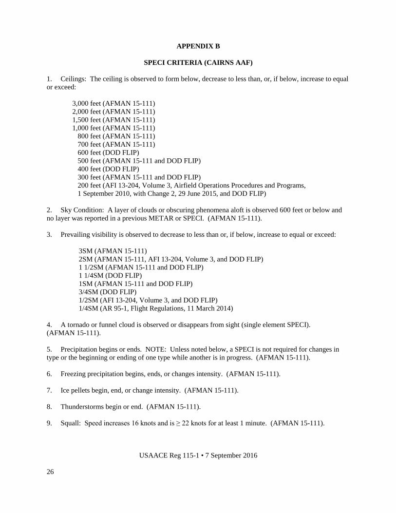
APPENDIX B
SPECI CRITERIA (CAIRNS AAF)
1. Ceilings: The ceiling is observed to form below, decrease to less than, or, if below, increase to equal
or exceed:
3,000 feet (AFMAN 15-111)
2,000 feet (AFMAN 15-111)
1,500 feet (AFMAN 15-111)
1,000 feet (AFMAN 15-111)
800 feet (AFMAN 15-111)
700 feet (AFMAN 15-111)
600 feet (DOD FLIP)
500 feet (AFMAN 15-111 and DOD FLIP)
400 feet (DOD FLIP)
300 feet (AFMAN 15-111 and DOD FLIP)
200 feet (AFI 13-204, Volume 3, Airfield Operations Procedures and Programs,
1 September 2010, with Change 2, 29 June 2015, and DOD FLIP)
2. Sky Condition: A layer of clouds or obscuring phenomena aloft is observed 600 feet or below and
no layer was reported in a previous METAR or SPECI. (AFMAN 15-111).
3. Prevailing visibility is observed to decrease to less than or, if below, increase to equal or exceed:
3SM (AFMAN 15-111)
2SM (AFMAN 15-111, AFI 13-204, Volume 3, and DOD FLIP)
1 1/2SM (AFMAN 15-111 and DOD FLIP)
1 1/4SM (DOD FLIP)
1SM (AFMAN 15-111 and DOD FLIP)
3/4SM (DOD FLIP)
1/2SM (AFI 13-204, Volume 3, and DOD FLIP)
1/4SM (AR 95-1, Flight Regulations, 11 March 2014)
4. A tornado or funnel cloud is observed or disappears from sight (single element SPECI).
(AFMAN 15-111).
5. Precipitation begins or ends. NOTE: Unless noted below, a SPECI is not required for changes in
type or the beginning or ending of one type while another is in progress. (AFMAN 15-111).
6. Freezing precipitation begins, ends, or changes intensity. (AFMAN 15-111).
7. Ice pellets begin, end, or change intensity. (AFMAN 15-111).
8. Thunderstorms begin or end. (AFMAN 15-111).
9. Squall: Speed increases 16 knots and is ≥ 22 knots for at least 1 minute. (AFMAN 15-111).
USAACE Reg 115-1 • 7 September 2016
27
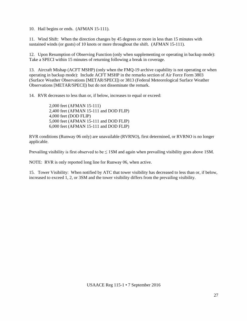
10. Hail begins or ends. (AFMAN 15-111).
11. Wind Shift: When the direction changes by 45 degrees or more in less than 15 minutes with
sustained winds (or gusts) of 10 knots or more throughout the shift. (AFMAN 15-111).
12. Upon Resumption of Observing Function (only when supplementing or operating in backup mode):
Take a SPECI within 15 minutes of returning following a break in coverage.
13. Aircraft Mishap (ACFT MSHP) (only when the FMQ-19 archive capability is not operating or when
operating in backup mode): Include ACFT MSHP in the remarks section of Air Force Form 3803
(Surface Weather Observations [METAR/SPECI]) or 3813 (Federal Meteorological Surface Weather
Observations [METAR/SPECI]) but do not disseminate the remark.
14. RVR decreases to less than or, if below, increases to equal or exceed:
2,000 feet (AFMAN 15-111)
2,400 feet (AFMAN 15-111 and DOD FLIP)
4,000 feet (DOD FLIP)
5,000 feet (AFMAN 15-111 and DOD FLIP)
6,000 feet (AFMAN 15-111 and DOD FLIP)
RVR conditions (Runway 06 only) are unavailable (RVRNO), first determined, or RVRNO is no longer
applicable.
Prevailing visibility is first observed to be ≤ 1SM and again when prevailing visibility goes above 1SM.
NOTE: RVR is only reported long line for Runway 06, when active.
15. Tower Visibility: When notified by ATC that tower visibility has decreased to less than or, if below,
increased to exceed 1, 2, or 3SM and the tower visibility differs from the prevailing visibility.

USAACE Reg 115-1 • 7 September 2016
28
APPENDIX C
FMQ-19 AUGMENTATION PARAMETERS
1. On 13 June 2007, the FMQ-19 automated observing system was commissioned, thereby transitioning
Cairns AAF from a manual reporting station to an automated reporting station. IAW Air Force directives,
the FMQ-19 must remain in AUTO mode at all times unless the technician is performing augmentation
for criteria listed in AFMAN 15-111. Augmentation consists of supplementing and/or backing up.
Supplementing is the process of manually adding data to an observation generated by an automated
surface weather observing system that is beyond that system’s capability to measure and report. Backing
up is the process of manually providing meteorological data, documentation, and/or communication of an
automated weather observation when the primary automated method is unavailable or unrepresentative.
All manually observed elements will be observed from the weather station’s backup observation point.
The technician is responsible for ensuring the validity of all augmented data. Augmentation will not
normally occur when the weather station is closed unless tornadic activity is occurring or forecast to
occur.
2. The following elements will be supplemented (AFMAN 15-111):
a. Tornado, funnel cloud, or waterspout.
b. Volcanic ash.
c. Hail.
d. Ice pellets.
e. Dust storm or sandstorm.
f. Snow depth.
3. The following is a list of the most commonly used mandatory parameters of the FMQ-19 (and
equipment used) which will be backed up when conditions impact operations based on criteria in
appendixes H, I, and J:
a. Wind speed and direction (Kestrel 4000).
b. Visibility (technician and visibility chart).
c. Present weather elements and obscurations (technician).
d. Sky cover, up to and including 12,000 feet (technician).
e. Temperature/dew point (Kestrel 4000).
f. Altimeter setting (Kestrel 4000).

USAACE Reg 115-1 • 7 September 2016
29
g. Lightning location (AFW-WEBS, OWS TAF Manager, technician).
h. Layer of clouds or obscuring phenomena aloft observed at or below 600 feet SPECI (technician).
i. Other remarks.
j. Additive data.

USAACE Reg 115-1 • 7 September 2016
30
APPENDIX D
WEATHER WATCH/WARNING/ADVISORY CRITERIA
1. Forecast Weather Watch Criteria (issued by the 26 OWS with FRWXOPS as a backup).
Table F.1 - Forecast Weather Watch Criteria and Desired Leadtimes
Criteria Desired Leadtime
Tornado As potential warrants
Severe Thunderstorm: winds > 45 knots and/or hail > 1/2
inch
As potential warrants
Damaging Winds > 45 knots As potential warrants
Heavy Rain (> 2 inches in 12 hours) As potential warrants
Snowfall > 1/2 inch accumulation As potential warrants
Freezing Precipitation As potential warrants
Lightning within 15 NM 60 minutes
NOTE: Unless otherwise noted, weather watches are issued for a 60 NM radius around Cairns AAF.
2. KTOI Forecast Weather Watch Criteria (issued by the 26 OWS with FRWXOPS as a backup).
Table F.2 - Forecast Weather Watch Criteria and Desired Leadtime (KTOI)
Criteria Desired Leadtime
Lightning within 5 NM 30 minutes
3. Forecast Weather Warning Criteria (issued by the 26 OWS with FRWXOPS as a backup).
Table F.3 - Forecast Weather Warning Criteria and Desired Leadtimes
Criteria Desired Leadtime
Tornado 5 minutes
Severe Thunderstorm: winds > 45 knots and/or hail > 1/2
inch
60 minutes
Moderate Thunderstorm: winds 30-44 knots and/or hail <
1/2 inch
60 minutes
Damaging Winds > 45 knots 60 minutes
Strong Winds 30-44 knots 60 minutes
Freezing Precipitation 60 minutes
Heavy Rain > 2 inches in 12 hours 60 minutes
Snowfall > 1/2 inch accumulation 60 minutes

USAACE Reg 115-1 • 7 September 2016
31
NOTE: Forecast warnings are issued for a 15 NM radius around Cairns AAF.
4. KTOI Forecast Weather Warning Criteria (issued by the 26 OWS with FRWXOPS as a backup).
Table F.4 - Forecast Weather Warning Criteria and Desired Leadtimes (KTOI)
Criteria Desired Leadtime
Tornado 5 minutes
Severe Thunderstorm: winds 45 knots and/or hail > 1/2 inch 60 minutes
Damaging Winds 45 knots 60 minutes
NOTE: Forecast warnings are issued for a 5 NM radius around Troy MAP during ATC duty hours at
Troy only.
5. Observed Weather Warning Criteria (issued by FRWXOPS with the 26 OWS as a backup).
Table F.5 - Observed Weather Warning Criteria and Desired Leadtime
Criteria Desired Leadtime
Lightning within 5 NM Observed
NOTE: Observed warnings are issued for a 5 NM radius around Cairns AAF.
6. KTOI Observed Weather Warning Criteria (issued by the 26 OWS with FRWXOPS as a backup).
Table F.6 - Observed Weather Warning Criteria and Desired Leadtime
Criteria Desired Leadtime
Lightning within 5 NM Observed
NOTE: Observed warnings are issued for a 5 NM radius around Troy MAP during ATC duty hours at
Troy only.
7. Forecast AWA Criteria (issued by FRWXOPS with the 26 OWS as a backup).
Table F.7 - Forecast AWA Criteria and Desired Leadtimes
Criteria Desired Leadtime
Forecast Predominant IFR conditions (< 1000/3) within 60 NM during the N1
flying period
60 minutes
Forecast IFR conditions associated with thunderstorms within 60 NM during the
N1 flying period
60 minutes
Forecast Predominant LIFR conditions (< 500/1) within 60 NM during the A.M.
and/or P.M. flying period
30 minutes
Forecast severe or greater TURBC within 60 NM (below 10,000 feet) 60 minutes
Forecast icing (any type/amount) within 60 NM (below 10,000 feet) 60 minutes

USAACE Reg 115-1 • 7 September 2016
32
NOTE: Forecast AWAs are issued for a 60 NM radius around Cairns AAF.
8. Observed AWA Criteria (issued by FRWXOPS with the 26 OWS as a backup).
Table F.8 - Observed AWA Criteria and Desired Leadtimes
Criteria Desired Leadtime
Winds 20 knots observed within 60 NM (not associated with thunderstorms) Observed
Moderate or greater TURBC observed within 60 NM (below 10,000 feet) Observed
LLWS observed within 60 NM (below 2,000 feet) Observed
Falling snow occurring at or below 2,000 feet Observed
IFR conditions (< 1000/3) observed within 60 NM during the N1 flying period Observed
Cig/Vis ≤ 1500/5 observed in Goldfish during the N1 flying period Observed
NOTE: Unless otherwise noted, observed AWAs are issued for a 60 NM radius around Cairns AAF.
9. Forecast TWA Criteria (issued by the 26 OWS with FRWOPS as a backup).
Table F.9 - Forecast TWA Criteria and Desired Leadtimes
Criteria Desired Leadtime
Temperature 0 degrees Celsius for 5 hours 60 minutes
Temperature -6 degrees Celsius 60 minutes
NOTE: Forecast TWAs are issued for a 15 NM radius around Cairns AAF.
10. Forecast TWA Criteria (issued by FRWXOPS with the 26 OWS as a backup).
Table F.10 - Forecast TWA Criteria and Desired Leadtimes
Criteria Desired Leadtime
Forecast Predominant IFR conditions (< 1000/3) within 15 NM during the N1
flying period
60 minutes
Forecast IFR conditions associated with thunderstorms within 15 NM during the
N1 flying period
60 minutes
Forecast Predominant LIFR conditions (< 500/1) within 15 NM during the A.M.
and/or P.M. flying period
30 minutes
NOTE: Forecast TWAs are issued for a 15 NM radius around Cairns AAF.
11. Observed TWA Criteria (issued by FRWXOPS with the 26 OWS as a backup).
Table F.11 - Observed TWA Criteria and Desired Leadtimes
Criteria Desired Leadtime
Gust Spread 15 knots Observed
Lightning observed within 10 NM Observed
25-knot crosswind Observed
IFR conditions (< 1000/3) observed within 15 NM during the N1 flying period Observed

USAACE Reg 115-1 • 7 September 2016
33
NOTE: Unless otherwise noted, observed TWAs are issued for a 15 NM radius around Cairns AAF.
12. Observed Weather Warning Criteria for basefields (issued by the 26 OWS with FRWXOPS as a
backup).
Table F.12 - Observed Weather Warning Criteria and Desired Leadtimes
Criteria Desired Leadtime
Lightning within 5 NM of Hanchey AHP Observed
Lightning within 5 NM of Knox AHP Observed
Lightning within 5 NM of Lowe AHP Observed
Lightning within 5 NM of Shell AHP Observed
Lightning within 5 NM of Molinelli FARP Observed
NOTE: Observed warnings for Molinelli FARP are only required during its operating hours,
0800L-0100L, Monday through Friday.
13. Observed Weather Advisory Criteria for basefields (issued by the 26 OWS with FRWXOPS as a
backup).
Table F.13 - Observed Weather Advisory Criteria and Desired Leadtimes
Criteria Desired Leadtime
Lightning within 10 NM of Hanchey AHP Observed
Lightning within 10 NM of Knox AHP Observed
Lightning within 10 NM of Lowe AHP Observed
Lightning within 10 NM of Shell AHP Observed
Lightning within 10 NM of Molinelli FARP Observed
14. Weather watches, warnings, and advisories are each numbered sequentially by month; e.g., the first
weather watch in August would be #08-001, the third weather warning in November would be #11-003,
and the tenth weather advisory in December would be #12-010.

USAACE Reg 115-1 • 7 September 2016
34
FIGURE 1
RESOURCE PROTECTION NOTIFICATION CHAIN
*For freezing precipitation/snow/heavy rain/temperature watches, warnings, and advisories, the
Emergency Management Control Section, DPW, will be notified. For lightning within 10 NM and 5 NM,
Refuel will be notified. For N1 IFR advisories and A.M. and P.M. LIFR advisories, ARAC and HUB
Radio will be notified. For the N1 Goldfish advisory, ARAC will be notified. For the falling snow
advisory, the Primary Division will be notified.
Generally, Cairns Base Operations disseminates watches, warnings, and advisories through operational
channels via the weather telephone. The IOC disseminates watches and warnings through administrative
channels. For details on how Cairns Base Operations and the IOC disseminate watches, warnings, and
advisories and a further breakdown of dissemination through individual organizations, see the Fort
Rucker All Hazards Installation Protection Plan, appendix H (Weather Plan).
26 OWS
FRWXOPS
FORT RUCKER IOC
CAIRNS BASE OPERATIONS
OTHER CUSTOMERS*
FORT RUCKER IOC

USAACE Reg 115-1 • 7 September 2016
35
APPENDIX E
BREAKDOWN OF THE DD FORM 175-1
1. Takeoff Data.
Block
Number
1 - Date of mission (Zulu).
2-3 - Typically not included on the DD Form 175-1; available upon request.
4 - Runway temperature for specific flight period times (A.M. - 0800L, P.M. - 1400L, N1 - 2000L).
5 - Dew point temperature for specific flight period times (A.M. - 0800L, P.M. - 1400L, N1 - 2000L).
6 - Typically not included on the DD Form 175-1; available upon request.
7 - PA for specific flight period times (A.M. - 0800L, P.M. - 1400L, N1 - 2000L).
8 - Typically not included on the DD Form 175-1; available upon request.
9-12 - Not included on the DD Form 175-1.
13 - Any watch, warning, or advisory (that affects flight operations) in effect at takeoff.
Exceptions: Lightning observed within 10 NM and 5 NM; Heavy rain warning.
2. Enroute & Mission Data.
Block
Number
14 - Flight level, winds, and temperatures (degrees Celsius). For USAACE operations, flight levels
typically range 010-080 feet and will be listed in this block.
15 - Space weather.
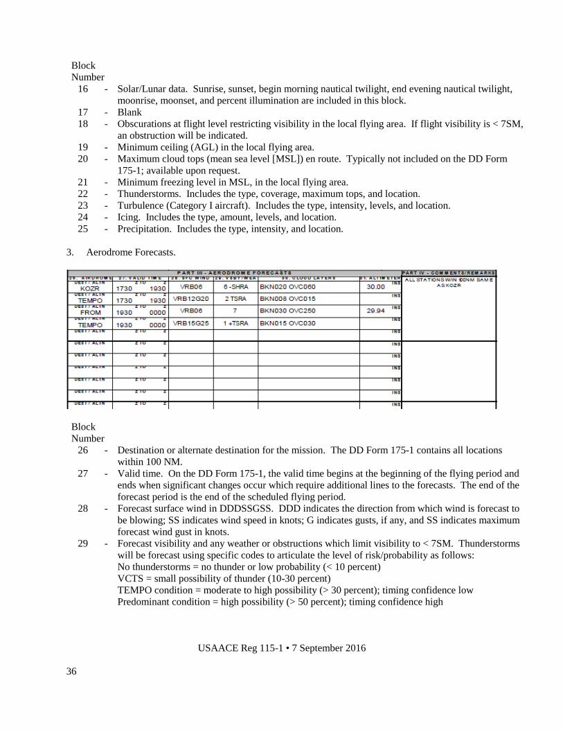
USAACE Reg 115-1 • 7 September 2016
36
Block
Number
16 - Solar/Lunar data. Sunrise, sunset, begin morning nautical twilight, end evening nautical twilight,
moonrise, moonset, and percent illumination are included in this block.
17 - Blank
18 - Obscurations at flight level restricting visibility in the local flying area. If flight visibility is < 7SM,
an obstruction will be indicated.
19 - Minimum ceiling (AGL) in the local flying area.
20 - Maximum cloud tops (mean sea level [MSL]) en route. Typically not included on the DD Form
175-1; available upon request.
21 - Minimum freezing level in MSL, in the local flying area.
22 - Thunderstorms. Includes the type, coverage, maximum tops, and location.
23 - Turbulence (Category I aircraft). Includes the type, intensity, levels, and location.
24 - Icing. Includes the type, amount, levels, and location.
25 - Precipitation. Includes the type, intensity, and location.
3. Aerodrome Forecasts.
Block
Number
26 - Destination or alternate destination for the mission. The DD Form 175-1 contains all locations
within 100 NM.
27 - Valid time. On the DD Form 175-1, the valid time begins at the beginning of the flying period and
ends when significant changes occur which require additional lines to the forecasts. The end of the
forecast period is the end of the scheduled flying period.
28 - Forecast surface wind in DDDSSGSS. DDD indicates the direction from which wind is forecast to
be blowing; SS indicates wind speed in knots; G indicates gusts, if any, and SS indicates maximum
forecast wind gust in knots.
29 - Forecast visibility and any weather or obstructions which limit visibility to < 7SM. Thunderstorms
will be forecast using specific codes to articulate the level of risk/probability as follows:
No thunderstorms = no thunder or low probability (< 10 percent)
VCTS = small possibility of thunder (10-30 percent)
TEMPO condition = moderate to high possibility (> 30 percent); timing confidence low
Predominant condition = high possibility (> 50 percent); timing confidence high

USAACE Reg 115-1 • 7 September 2016
37
30 - Forecast cloud layers in METAR code.
31 - Forecast minimum ALSTG.
NOTE: Large blocks to the right will indicate destinations in the local flying area that are within 100 NM
and have the same or similar forecast. If all locations are the same, there will be a remark stating A/S, or
all stations, are the same or better.
NOTE: Locations in the local flying area outside 100 NM but within 150 NM will be listed on a
continuation sheet. These include Jack Edwards (KJKA), Bay Minette (K1R8), Foley Muni (K5R4),
Tuscaloosa (KTCL), Chilton County (K02A), Crisp County (KCKF), LaGrange (KLGC), Moody AFB
(KVAD), Valdosta (KVLD), and Tifton (KTMA).
4. Comments/Remarks.
Block
Number
35 - Remarks. Used to comment on significant phenomena not covered elsewhere. Inludes KOZR
maximum temperature, PA, and DA for the flying period.
NOTE: This area includes several methods to contact FRWXOPS for updates, including PMSV
frequencies, telephone numbers, and social media sites.
5. Briefing Record.
Block
Number
36 - WX briefed time. Initial weather brief time (Zulu) for each applicable flying period.
37 - Flimsy briefing number. The applicable flying period and valid times are entered in this block.
38 - Forecaster’s initials.
39 - Not included on the DD Form 175-1.
40 - Void time. Initial weather void time (Zulu) for each applicable flying period.
41 - Extended to/initials. The new void time is entered in this block, along with the forecaster’s initials.
42 - WX rebrief time/initials. The new brief time is entered in this block, along with the forecaster’s
initials.
43 - Not included on the DD Form 175-1.

USAACE Reg 115-1 • 7 September 2016
38
APPENDIX F
BREAKDOWN OF THE MEF
1. Part I: Date/Valid Time/Briefer.
2. Part II: Flight level winds and temperatures (degrees Celsius) are listed 010-080.
3. Part III: KOZR & Area Forecast Data. This block lists the maximum/minimum temperatures
(degrees Celsius) at KOZR and in the local flying area, the minimum ALSTG at KOZR and in the local
flying area, the maximum PA/DA at KOZR and in the local 150 NM flying area, the minimum ceiling at
KOZR and in the local flying area, and the minimum visibility/weather at KOZR and in the local flying
area.
4. Part IV: Solar & Lunar Data (Local Time). The azimuth and elevation are valid for 2100L.
5. Part V: Any flight hazards are identified in this block. Turbulence (Category I aircraft) is identified
by type, intensity, and levels. Icing is identified by type, intensity, and levels. Thunderstorms are
identified by type, coverage, and maximum tops.
6. Part VI: MEF Area Forecasts. This block breaks down the forecast for each MEF forecast area for
the entire period. Grid lines will be used to divide areas further when weather conditions dictate the need
for greater detail. If thunderstorms are forecast, the maximum instantaneous coverage for each area is
listed in the blocks to the right. There is also a space for remarks to expand on any area forecast and/or
briefly describe amendments or updates.
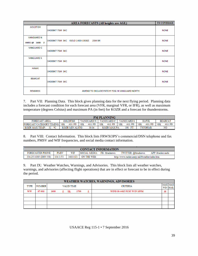
USAACE Reg 115-1 • 7 September 2016
39
7. Part VII: Planning Data. This block gives planning data for the next flying period. Planning data
includes a forecast condition for each forecast area (VFR, marginal VFR, or IFR), as well as maximum
temperature (degrees Celsius) and maximum PA (in feet) for KOZR and a forecast for thunderstorms.
8. Part VIII: Contact Information. This block lists FRWXOPS’s commercial/DSN telephone and fax
numbers, PMSV and WIF frequencies, and social media contact information.
9. Part IX: Weather Watches, Warnings, and Advisories. This block lists all weather watches,
warnings, and advisories (affecting flight operations) that are in effect or forecast to be in effect during
the period.
USAACE Reg 115-1 • 7 September 2016
40
APPENDIX G
MEF FORECAST AREAS DEFINED
1. The MEF includes six forecast areas. Grid lines will be used to divide areas further when weather
conditions dictate the need for greater detail. In the context of this regulation and all forecast products
issued by FRWXOPS, these six forecast areas are:
a. BEARCAT. Synonymous with Area of Operations (AO) Bearcat as defined in Fort Rucker
Reg 95-2. Specific airfields include High Falls Stagefield, Tri-County MAP, and Marianna MAP.
b. HAWK. Synonymous with AO Hawk as defined in Fort Rucker Reg 95-2. Specific airfields
include Molinelli Range, Tabernacle Stagefield, Hunt Stagefield, Hatch Stagefield, Hooper Stagefield,
Ech Stagefield, and Goldberg Stagefield.
c. VANGUARD. The boundaries of VANGUARD are the same as AO Vanguard as defined in
Fort Rucker Reg 95-2. However, in an effort to provide a more detailed forecast, VANGUARD NORTH,
VANGUARD CENTRAL, and VANGUARD SOUTH, as defined below, will be used.
(1) VANGUARD NORTH. The southern boundary is the EV 80 east-west grid line. Specific
airfields include Troy MAP, Louisville Stagefield, and Greenville MAP.
(2) VANGUARD CENTRAL. The northern boundary is the EV 80 east-west grid line and
the southern boundary is the EV 40 east-west grid line. Specific airfields include South Alabama RAP,
Stinson Stagefield, Runkle Stagefield, Skelly Stagefield, Brown Stagefield, Lucas Stagefield, and TAC-X
training site.
(3) VANGUARD SOUTH. The northern boundary is the EV 40 east-west grid line. Specific
airfields include Florala MAP and Crestview, FL.
d. GOLDFISH. Specific airfields include Hanchey AHP, Knox AHP, Dothan MAP, Cairns AAF,
Lowe AHP, Shell AHP, Highbluff Stagefield, Allen Stagefield, Toth Stagefield, and Enterprise MAP.
2. The six MEF forecast areas are depicted below.

USAACE Reg 115-1 • 7 September 2016
41
USAACE Reg 115-1 • 7 September 2016
42
APPENDIX H
MEF SPECIFICATION CRITERIA
1. Specification Criteria. The VFR MEF specifies the onset and duration of the following elements:
a. Thunderstorms. Timing and coverage.
b. Weather watches, warnings, and advisories that are in effect or will be in effect during the
period.
c. Surface winds gusting to ≥ 20 knots within the local flying area.
d. Ceiling. When a ceiling decreases to less than or, if below, increases to equal or exceed:
1,700 feet ( Lowe MTP)
1,000 feet (Primary Division launch minimum, Head Hunter day minimum, Advanced Division,
23d Flying Training Squadron [23d FTS], FLATIRON, AH-64D, OH-58A/C, UH-60,
UH-72A, TH-67, CH-47 night training minimum)
700 feet (Primary Division launch minimum and stagefield training minimum, 23d FTS day
training minimum)
600 feet (Advanced Division alternate minimum)
500 feet (FLATIRON night training on Cairns AAF minimum, AH-64D, OH-58A/C, UH-60,
TH-1, UH-72A, TH-67, CH-47 day training minimum)
300 feet (FLATIRON day training minimum, Advanced Division Special VFR minimum)
200 feet (C-12 Reserves launch minimum, Advanced Division day training minimum)
100 feet (MEDEVAC launch minimum)
e. Visibility. When visibility decreases to less than or, if below, increases to equal or exceed:
3SM (Primary Division launch minimum, Advanced Division, 23d FTS, FLATIRON, AH-64D,
OH-58A/C, UH-60, UH-72A, TH-1, TH-67, CH-47 night training minimum; Head Hunter
day/night minimum)
2SM (23d FTS day training minimum)
1SM (Primary Division launch minimum and stagefield training minimum, FLATIRON night
training on Cairns AAF minimum, AH-64D, OH-58A/C, UH-60, TH-67, UH-72A, TH-1,
CH-47 day training minimum)
1/2SM (Advanced Division Special VFR minimum, C-12 Reserves launch minimum,
FLATIRON, AH-64D, UH-72A, UH-60 day training minimum)
1/4SM (Advanced Division day training minimum, MEDEVAC launch minimum)
USAACE Reg 115-1 • 7 September 2016
43
MEF AMENDMENT CRITERIA
2. Amendment Criteria. The VFR MEF is amended when any of the following elements have been
incorrectly forecast:
a. Thunderstorms. Timing and/or coverage of few or greater.
b. Weather Watches, Warnings, or Advisories. Weather watch, warning, or advisory criteria are
met and were not forecast or, if specified, are no longer expected to occur.
c. Surface Winds. When the forecast surface wind speed, including gusts, is in error by 10 knots or
more.
d. Surface Winds. When the direction of the forecast surface winds is in error by 30 degrees or
more and the predominant wind speed, including gusts, is over 15 knots.
e. Ceiling and Visibility. When ceilings decrease to less than or, if below, increase to equal or
exceed the following categories (category is determined by the lower ceiling or visibility value):
Category F: Ceiling > 1,000 feet; visibility > 3SM.
Category E: Ceiling < 1,000 feet and > 700 feet; visibility < 3SM and > 2SM.
Category D: Ceiling < 700 feet and > 600 feet; visibility < 2SM and > 1 1/4SM.
Category C: Ceiling < 600 feet and > 500 feet; visibility < 1 1/4SM and > 1SM.
Category B: Ceiling < 500 feet and > 200 feet; visibility < 1SM and > 1/4SM.
Category A: Ceiling < 200 feet; visibility < 1/4SM.
NOTE: Categories B, C, and D are required during A.M. and P.M. periods only.
USAACE Reg 115-1 • 7 September 2016
44
APPENDIX I
USAACE WEATHER SUPPORT REQUIREMENTS/CUSTOMER ACTIONS
The following table lists weather events and thresholds that impact or potentially impact Fort Rucker
operations. Customer actions for these weather events and thresholds are also listed.
Weather Event Affected Unit Impact Customer Action
Tornadoes
Tornado All Threat to post populace,
resources Sound alarm; take cover, cancel flight ops.
Wind Thresholds
Wind 45 knots IOC Possible damage to post Override CCTV; implement HURCON Plan,
if appropriate.
110th AB Possible aircraft damage
Cancel flights; recover aircraft,
hangar/secure aircraft. Run up limit for UH-
72A, UH-60,
AH-64, TH-67, and OH-58A/C.
Aircraft Possible damage to aircraft
and equipment Stack, hangar, or secure aircraft.
Logistics Mgmt
Div Secure flight line equipment.
DPW Damage to unsecured job
sites Secure job sites and materials.
Wind 35-44
knots 110th AB Possible aircraft damage Cancel or hold flights.
Wind 30 knots 110th AB Hazard to rotary wing
aircraft during runup
Delay flights. Affects TH-67 and UH-1
aircraft.
Gust Spread
15 knots 110th AB
Hazard to rotary wing
aircraft during runup
Delay flights. Affects TH-1, TH-67, and
OH-58A/C models.
Wind 20 knots 110th AB Decision point
Alert crews that winds could approach
airframe limits. Limit training on
autorotation landings. Aircraft cannot be on
jacks.
Gusty
Chief of Staff
(CoS)/Secretary
of the General
Staff (SGS)
Outdoors formation
undesirable Move formation indoors.
LLWS 110th AB Hazard to light aircraft Cancel or hold flights.
X wind 25
knots
110th AB/
AF Det 5 Aircraft restriction Cancel or hold flights.
Flight/Ground Hazards
Turbulence
Moderate+ 110th AB Hazard to light aircraft Cancel student solo flights.
Severe+ 110th AB Hazard to aircraft Cancel flights.
Icing
Moderate+ 110th AB Hazard to rotary wing
aircraft Cancel flights.
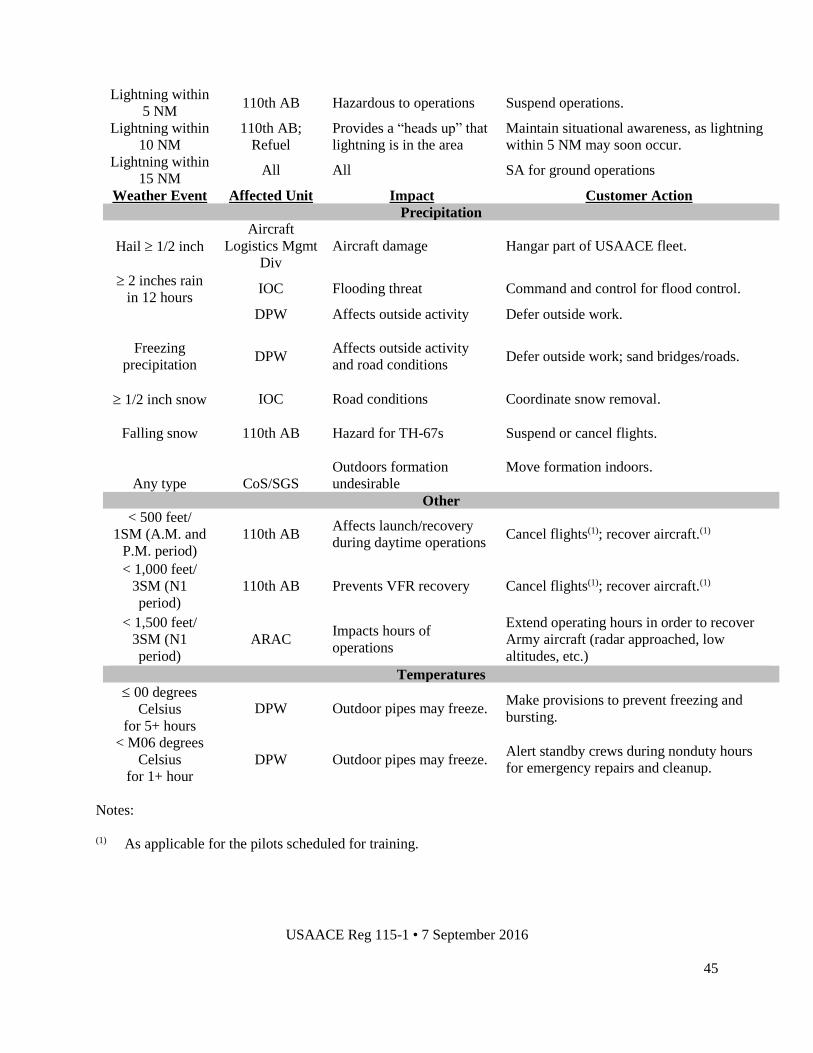
USAACE Reg 115-1 • 7 September 2016
45
Lightning within
5 NM 110th AB Hazardous to operations Suspend operations.
Lightning within
10 NM
110th AB;
Refuel
Provides a “heads up” that
lightning is in the area
Maintain situational awareness, as lightning
within 5 NM may soon occur.
Lightning within
15 NM All All SA for ground operations
Weather Event Affected Unit Impact Customer Action
Precipitation
Hail 1/2 inch
Aircraft
Logistics Mgmt
Div
Aircraft damage Hangar part of USAACE fleet.
2 inches rain
in 12 hours IOC Flooding threat Command and control for flood control.
DPW Affects outside activity Defer outside work.
Freezing
precipitation DPW
Affects outside activity
and road conditions
Defer outside work; sand bridges/roads.
1/2 inch snow IOC Road conditions Coordinate snow removal.
Falling snow
Any type
110th AB
CoS/SGS
Hazard for TH-67s
Outdoors formation
undesirable
Suspend or cancel flights.
Move formation indoors.
Other
< 500 feet/
1SM (A.M. and
P.M. period)
110th AB Affects launch/recovery
during daytime operations Cancel flights(1); recover aircraft.(1)
< 1,000 feet/
3SM (N1
period)
110th AB Prevents VFR recovery Cancel flights(1); recover aircraft.(1)
< 1,500 feet/
3SM (N1
period)
ARAC Impacts hours of
operations
Extend operating hours in order to recover
Army aircraft (radar approached, low
altitudes, etc.)
Temperatures
00 degrees
Celsius
for 5+ hours
DPW Outdoor pipes may freeze. Make provisions to prevent freezing and
bursting.
< M06 degrees
Celsius
for 1+ hour
DPW Outdoor pipes may freeze. Alert standby crews during nonduty hours
for emergency repairs and cleanup.
Notes:
(1) As applicable for the pilots scheduled for training.
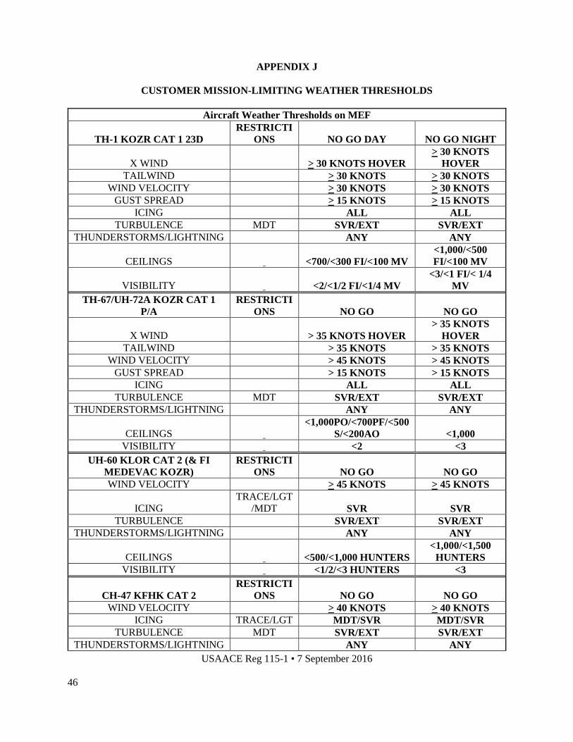
USAACE Reg 115-1 • 7 September 2016
46
APPENDIX J
CUSTOMER MISSION-LIMITING WEATHER THRESHOLDS
Aircraft Weather Thresholds on MEF
TH-1 KOZR CAT 1 23D
RESTRICTI
ONS NO GO DAY NO GO NIGHT
X WIND > 30 KNOTS HOVER
> 30 KNOTS
HOVER
TAILWIND > 30 KNOTS > 30 KNOTS
WIND VELOCITY > 30 KNOTS > 30 KNOTS
GUST SPREAD > 15 KNOTS > 15 KNOTS
ICING ALL ALL
TURBULENCE MDT SVR/EXT SVR/EXT
THUNDERSTORMS/LIGHTNING ANY ANY
CEILINGS <700/<300 FI/<100 MV
<1,000/<500
FI/<100 MV
VISIBILITY <2/<1/2 FI/<1/4 MV
<3/<1 FI/< 1/4
MV
TH-67/UH-72A KOZR CAT 1
P/A
RESTRICTI
ONS NO GO NO GO
X WIND > 35 KNOTS HOVER
> 35 KNOTS
HOVER
TAILWIND > 35 KNOTS > 35 KNOTS
WIND VELOCITY > 45 KNOTS > 45 KNOTS
GUST SPREAD > 15 KNOTS > 15 KNOTS
ICING ALL ALL
TURBULENCE MDT SVR/EXT SVR/EXT
THUNDERSTORMS/LIGHTNING ANY ANY
CEILINGS <1,000PO/<700PF/<500
S/<200AO <1,000
VISIBILITY <2 <3
UH-60 KLOR CAT 2 (& FI
MEDEVAC KOZR)
RESTRICTI
ONS NO GO NO GO
WIND VELOCITY > 45 KNOTS > 45 KNOTS
ICING
TRACE/LGT
/MDT SVR SVR
TURBULENCE SVR/EXT SVR/EXT
THUNDERSTORMS/LIGHTNING ANY ANY
CEILINGS <500/<1,000 HUNTERS
<1,000/<1,500
HUNTERS
VISIBILITY <1/2/<3 HUNTERS <3
CH-47 KFHK CAT 2
RESTRICTI
ONS NO GO NO GO
WIND VELOCITY > 40 KNOTS > 40 KNOTS
ICING TRACE/LGT MDT/SVR MDT/SVR
TURBULENCE MDT SVR/EXT SVR/EXT
THUNDERSTORMS/LIGHTNING ANY ANY

USAACE Reg 115-1 • 7 September 2016
47
CEILINGS <500 <1,000
VISIBILITY <1 <3
OH-58 KSXS CAT 1 AH-64
KHEY CAT 2
RESTRICTI
ONS NO GO NO GO
WIND VELOCITY > 45 KNOTS > 45 KNOTS
ICING ALL ALL
TURBULENCE MDT SVR/EXT SVR/EXT
THUNDERSTORMS/LIGHTNING ANY ANY
CEILINGS <500 <1,000
VISIBILITY <1 OH-58/<1/2 AH-64 <3
C-12 (BE20) KOZR
RESTRICTI
ONS NO GO NO GO
X WIND > 25 KNOTS > 25 KNOTS
ICING SVR SVR
TURBULENCE SVR/EXT SVR/EXT
THUNDERSTORMS/LIGHTNING ANY ANY
CEILINGS <200 <200
VISIBILITY <1/2 <1/2