u.s. programs & policy ken alexander senior advisor, national coordination office cns/atm 2008...
TRANSCRIPT
U.S. Programs & Policy
Ken AlexanderSenior Advisor, National Coordination Office
CNS/ATM 2008Armed Forces Communications and Electronics Association
and 853d Electronic Systems Group
Tampa, FloridaJune 26, 2008

2
Overview
• Introduction• Global Positioning System• GPS Augmentations/Backups• U.S. Policy• International Cooperation

3ENC-GNSS 04/23/08

4
New Applications Evolving Every Day• Environmental Monitoring• Excavation/Open pit mining • Automatic snowplow
guidance• Child/Pet tracking• Spacecraft control• Wireless/Mobile
applications

5
GNSS is Key to Scientific Monitoringof the Earth
To better understand the changes and complex dynamic processes of our home planet
To better understand the changes and complex dynamic processes of our home planet

6
Keys to the Global Success of GPS
• Program Stability and Performance– Civil service performance commitment met continuously
since December 1993– Continuity of constellation and signals ensured through
Air Force operation and acquisition– Continuous improvements in accuracy, availability, etc.– Funding through U.S. taxpayers
• Policy Stability and Transparency– Open access to civil GPS signals, free of direct user fees– Open, free, and stable technical documentation– Market-based competition worldwide– Liberal export controls on GPS user equipment– National-level policy coordination including civil and
military leaders
• Commercial Entrepreneurship and Investment

7
Overview
• Introduction• Global Positioning System• GPS Augmentations/Backups• U.S. Policy• International Cooperation

8
The Global Positioning System
• Baseline 24 satellite constellation in medium earth orbit
• Global coverage, 24 hours a day, all weather conditions
• Satellites broadcast precise time and orbit information on L-band radio frequencies
• Two types of signals:– Standard (free of direct user fees)– Precise (U.S. and Allied military)
• Three segments: – Space– Ground control– User equipment

9
GPS Constellation Status
• 13 Block IIA• 12 Block IIR• 6 Block IIR-M
– Transmitting new second civil signal
• Continuously assessing constellation health to determine launch need– 2 Block IIR-M’s remaining– Next launch: September 2008
31 Operational SatellitesAs of June 1, 2008 (Baseline Constellation: 24)
31 Operational SatellitesAs of June 1, 2008 (Baseline Constellation: 24)
GPS is moving into its 4th Decade of Service
First Launch 22 Feb 1978
GPS is moving into its 4th Decade of Service
First Launch 22 Feb 1978

10
4.64.3
3.02.7
2.11.8
1.51.1
0
1
2
3
4
5
6
7
1990 1992 1994 1996 1997 1999 2001 2005
RM
S U
ser R
ange
Err
or (m
)
Continuous Performance Improvement
Decreasing range error
Year
Key measures of effectiveness to evaluate GPS services– Accuracy– Bounded inaccuracy– Integrity– Assured availability– Resistance to RF interference/jamming
Performance Standard

11
USG Commitment to GPS
• Based on a constellation with 24 Nominal Plane/Slot Positions
• 24 Operational Satellites 95% (averaged over any day)
– All 24 may not be operating
– Not All SVs may be located in Primary Orbit Slots
• 21 of 24 Plane/Slot Positions must be set healthy and transmitting a navigation signal with 98% probability (averaged yearly)
• 6 meter User Range Error (URE)

12
2
4
6
8
10
Yea
rs
Satellite 39 35 34 36 33 40 30 38 43 46 51 44
12
41 54 56
14
45
16
47 59 60 61 5325 26 27 32 37 52 58
GPS Constellation StatusSatellite Age as of March 2008
2423 55 57
BLOCK IIA BLOCK IIR BLOCK IIR-M

13
Recent GPS Improvements
• Expanded GPS ground network to triple amount of monitor data sent to control station– 10-15% improvement in accuracy of GPS data
broadcast
• Launched 3 modernized satellites in past 8 months– Largest GPS constellation size ever– Retiring old satellites improves overall GPS accuracy
• Transitioned to entirely new, modernized master control station– Improved operational flexibility and responsiveness– Added backup control station

14
GroundAntenna
Master Control Station (Schriever AFB)
GPS Operational Control Segment (OCS)
AscensioAscensionn
Diego Diego GarciaGarcia
Cape Cape CanaveralCanaveralHawaiiHawaii
Kwajalein Kwajalein
Schriever Schriever AFB AFB
ColoradoColorado S KoreaS Korea
AustraliaAustralia
BahrainBahrain
S AfricaS Africa
EnglandEngland
ArgentinaArgentina
EcuadorEcuador
TahitiTahiti
USNOUSNO
AlaskaAlaska
MonitorStation
New New ZealanZealandd
Vandenberg Vandenberg AFB AFB
CaliforniaCalifornia
NGA Monitor Station
OCS Monitor Station
Ground Antenna Future Monitor Station
Master Control Station
Backup Master Control Station

15
GPS III (Block C)• Increased accuracy • Increased signal
strength• Signal integrity• Search and Rescue• Common Galileo
OS/GPS (L1C)
Legacy (Block IIA/IIR)• Basic GPS• C/A civil signal (L1C/A)• Std Pos. Service• Precise Pos. Service
• L1 & L2 P(Y) nav
Modernized (Block IIR-M)• 2nd civil signal (L2C)• M-Code signals (L1M, L2M)
SatellitesModernized (Block IIF) • 3rd civil signal (L5)
Upgraded (AEP)• IIR-M IIF TT&C• WAGE, AII, LADO• New MCS/AMCS
Legacy• TT&C• L1 & L2 monitoring
Control Systems
User EquipmentLegacy• Man Pack• MAGR, PLGR• RCVR-3A, 3S • OH, UH• FRPA, CRPA
Upgraded• DAGR• CSEL
• GAS-1• MAGR2K• GB-GRAM
Modernized• MUE• MSR
OCX Block 2• L1C
OCX Block 1 (Modernized)• New Architecture• L2C, L5, M-Code• Flex Power OCX Block 3/4)
• Spot Beam • Mission Planning• Near-real Time
Command and Control
All Segment – GPS Modernization

16
Benefits of GPS Modernization
• System-wide improvements in accuracy, availability, integrity, and reliability to:
– Meet increasing civil, commercial and military demands
– Remain the pre-eminent space-based military PNT system
• Higher standalone accuracy
• More robust against interference
• Provides separate more secure Military signal
• Capability for second (L2C) and third (L5) civil signals
• Delivers L1C for interoperability with other GNSS
• Improved indoor, mobile, and urban use

17
Third Civil Signal (L5)
• Increasing interoperability – Galileo E5a, GLONASS, Compass,
QZSS, WAAS & other SBAS• Demonstration signal in 2008• 24 satellites by 2018
• Designed to meet demanding requirements for aviation safety– Uses highly protected Aeronautical Radionavigation Service
(ARNS) band• Wider bandwidth improves resistance to
interference• Signal Structure for enhanced performance• Higher power than other GPS signals

18
GPS II and GPS IIIA
USER SEGMENT
CONTROL SEGMENT
SPACE SEGMENT
GPS SISINTERFAC
E
SIS Integrity: 1e-5/SV/hr
10 SVs Visible: 1e-4/hr
Augmentation
• RAIM
• DGPS
Accuracy: 1.0 – 4.0 m rms
Navigation Integrity: 1e-7/hr

19
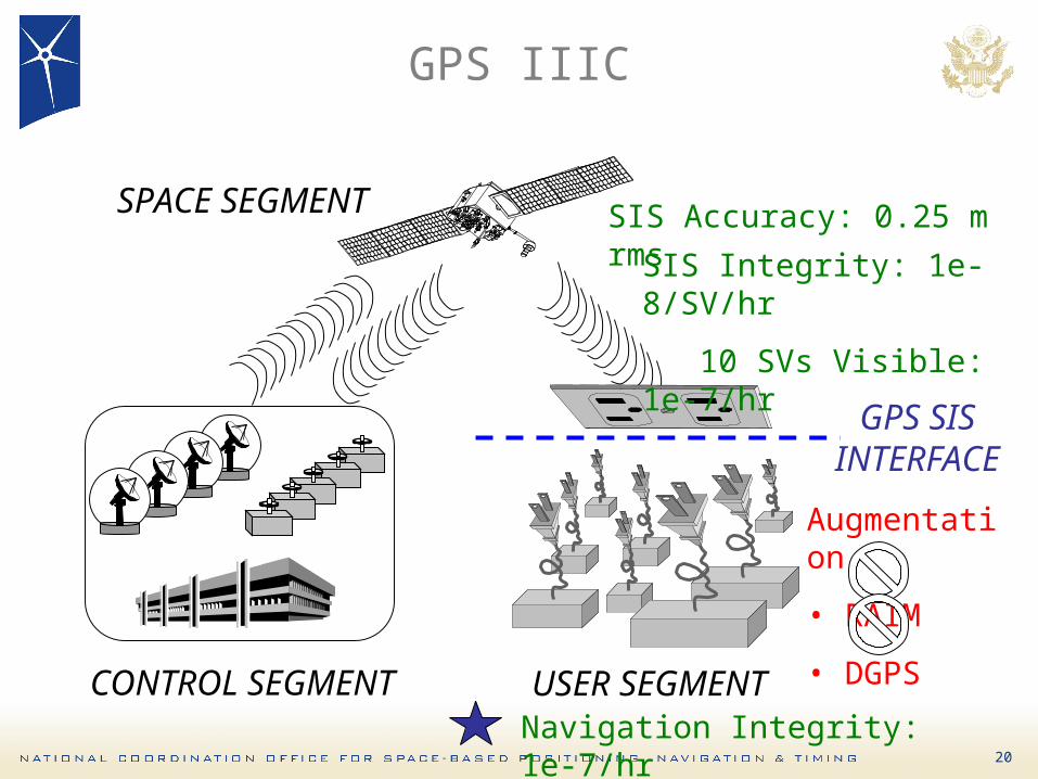
GPS Critical to Safety-of-Life Applications
Positioning Signal Integrity and Continuity Assurance (PSICA) is needed to ensure GPS IIIC meets stringent requirements for safety-of-life
(e.g., aviation) application
20
GPS IIIC
USER SEGMENTCONTROL SEGMENT
SPACE SEGMENT
GPS SISINTERFA
CEAugmentation
• RAIM
• DGPS
SIS Integrity: 1e-8/SV/hr
10 SVs Visible: 1e-7/hr
SIS Accuracy: 0.25 m rms
Navigation Integrity: 1e-7/hr
21
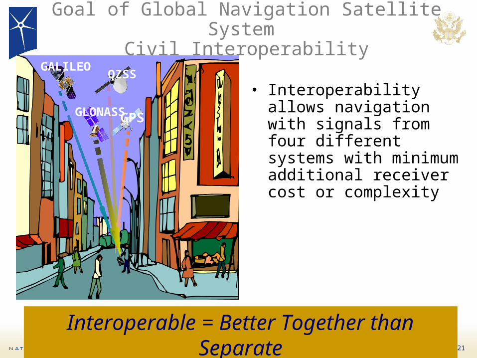
Goal of Global Navigation Satellite System Civil Interoperability
• Interoperability allows navigation with signals from four different systems with minimum additional receiver cost or complexity
GPS
QZSSGALILEO
GLONASS
Interoperable = Better Together than Separate

22
GPS Summary
• Success in GPS sustainment & modernization– New capabilities delivering enhanced performance
– Developments on track to enhance space and control and user segments
• GPS is an excellent global navigation utility– Excellent cooperation with augmentation service
providers
– U.S. looks forward to working with all to ensure GNSS civil systems are interoperable for the benefit of all users
• U.S. is continuing to modernize and improve GPS– To remain the pre-eminent space-based PNT service
– To lead the future GNSS system-of-systems

23
Overview
• Introduction• Global Positioning System• GPS Augmentations/Backups• U.S. Policy• International Cooperation

24
Augmentations Improve GPS Performance
Enhanced accuracy• <1.5 m WAAS vertical accuracy
for aviation• 2-5 cm for real-time
positioning, surveying, etc.• <1 cm for geodesy, geology,
etc.
Integrity monitoring• 6 sec time to alarm for aviation
.

25
U.S. Augmentations
Nationwide Differential GPS
Local Area Augmentation System
Continuously Operating Reference Stations
Wide Area Augmentation System

26
International Augmentations
Differential GPS Networks
International GNSS Service Global Differential GPS System
Space-Based Augmentation Systems

27
Wide Area Augmentation System
• Two replacement satellites launched in 2005– Dual coverage over United
States
– Ranging improves availability
– Integrity corrections for clock, ephemeris, and ionosphere
• Service expanded into Canada and Mexico– Reference stations in
Mexico (5) and Canada (4) support operations since 2007
Telesat107W
Intelsat133W

28
Enhanced Loran as National Backup to GPS
• Enhanced Loran (eLoran) announced as national backup to GPS for PNT in Feb 2008– As recommended by
Independent Assessment Team and National Executive Committee
– Funded through Department of Homeland Security
• Will replace legacy Loran-C system

29
Overview
• Introduction• Global Positioning System• GPS Augmentations/Backups• U.S. Policy• International Cooperation

30
U.S. Policy History
• 1978: First GPS satellite launched
• 1983: President offered free civilian GPS access to GPS
• 1996: Established joint civil/military GPS management
• 1997: Congress passes law providing civil GPS access free of direct user fees
• 2000: President set Selective Availability to “Zero”
• 2004: President issues U.S. Policy on Space-Based PNT
• 2007: President announces Selective Availability eliminated from future GPS III satellites

31
U.S. Policy Promotes Global Use of GPS Technology
• No direct user fees for civil GPS services– Provided on a continuous, worldwide basis
• Open, public signal structures for all civil services– Promotes equal access for user equipment
manufacturing, applications development, and value-added services
– Encourages open, market-driven competition• Improve performance of civil GPS and
augmentations to meet or exceed that of international systems
• Encourage international development of PNT systems based on GPS
• Global compatibility and interoperability with GPS
• Protection of radionavigation spectrum from disruption and interference
• Address mutual security concerns with international providers to prevent hostile use

32
U.S. Space-Based PNT Organization Structure
WHITE HOUSEWHITE HOUSE
ADVISORY BOARD
Sponsor: NASA
ADVISORY BOARD
Sponsor: NASA
NATIONALEXECUTIVE COMMITTEEFOR SPACE-BASED PNT
Executive Steering Group
Co-Chairs: Defense, Transportation
NATIONALEXECUTIVE COMMITTEEFOR SPACE-BASED PNT
Executive Steering Group
Co-Chairs: Defense, Transportation
NATIONAL COORDINATION OFFICE
Host: Commerce
NATIONAL COORDINATION OFFICE
Host: Commerce
GPS International Working Group
Chair: State
GPS International Working Group
Chair: State
Engineering Forum
Co-Chairs: Defense, Transportation
Engineering Forum
Co-Chairs: Defense, Transportation
Ad HocWorking Groups
Ad HocWorking Groups
DefenseDefense
TransportationTransportation
StateState
InteriorInterior
AgricultureAgriculture
CommerceCommerce
Homeland SecurityHomeland Security
Joint Chiefs of StaffJoint Chiefs of Staff
NASANASA

33
Executive Committee Activities
• Program Coordination– Five-Year National Plan– National PNT Architecture– GPS Modernization– Civil GPS Funding– Nationwide Differential
GPS– Enhanced LORAN– Distress Alerting Satellite
System
• International Cooperation– Bilateral– Multilateral
• Spectrum Management– Interference Detection
and Mitigation Plan– Spectrum Protection Plan
• Outreach– Publications, websites– Educational exhibit– Conferences, workshops,
other venues– Coordination of U.S.
message

34
Overview
• Introduction• Global Positioning System• GPS Augmentations/Backups• U.S. Policy• International Cooperation

35
International Cooperation
• Cooperative relationships established with Europe, Japan, Russia, India, Australia
• U.S. goals:– Compatibility and
interoperability– National security– Level playing field in global
markets
• Multilateral cooperation– International Committee on
GNSS– ICAO, IMO, NATO

36
Planned GNSS
• Global Constellations– GPS (US)
– GLONASS (Russia)
– Galileo (EU)
– Compass (China)
• Regional Constellations– QZSS (Japan)
– IRNSS (India)
• Satellite-Based Augmentations– WAAS (US)
– MSAS (Japan)
– EGNOS (EU)
– GAGAN (India)

37
Compatibility/Interoperability Objectives
• Ensure compatibility ― ability of U.S. and non-U.S. space based PNT services operating separately or together without interfering with each individual service or signal
– Radio frequency compatibility
– Spectral separation between M code and other signals
• Achieve interoperability – ability of civil U.S. and non-U.S. space-based PNT services operating together to provide better user capabilities than by relying on one service or signal
– Primary focus on the common L1C and L5 signalsPursue through Bi-lateral and Multi-lateral
CooperationPursue through Bi-lateral and Multi-lateral
Cooperation

38
International Committee on GNSS
• Promotes GNSS use and integration into infrastructures, particularly in developing countries
• Encourages system compatibility, interoperability
• Membership: GNSS providers, international organizations and associations
• Providers Forum– United States, Europe, Russia, China, India,
Japan– Focused discussions on compatibility,
interoperability
• Next plenary in Pasadena, Dec 2008

39
Summary
• GPS performance continues to improve– Augmentations enable even higher performance– New GPS signals are available now
– Modernization providing unprecedented new capabilities • U.S. policy encourages worldwide use of civil GPS
and augmentations• International cooperation is a high priority
– Actively engaged in multi-lateral/bi-lateral consultations
• As new GNSS systems and applications emerge, compatibility and interoperability are critical
• The U.S. goal is to maintain GPS as the recognized global “Gold Standard” – U.S. military PNT pre-eminence is a continuing priority

6822 Herbert C. Hoover BuildingWashington, D.C. 20230United States of America
Tel: +1 (202) 482-5809Email: [email protected]
Presentations and additional information:www.pnt.gov

BACKUPS

43
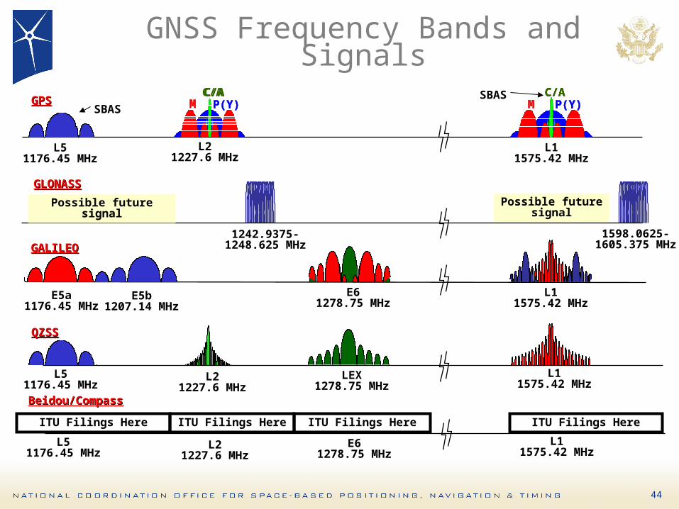
44
L51176.45 MHz
E5a1176.45 MHz
E5b1207.14 MHz
L21227.6 MHz
E61278.75 MHz
L11575.42 MHz
L11575.42 MHz
1242.9375-1248.625 MHz
1598.0625-1605.375 MHz
GLONASSGLONASS
GALILEOGALILEO
L51176.45 MHz
L21227.6 MHz
LEX1278.75 MHz
L11575.42 MHz
QZSSQZSS
GPSGPS MMMMMMMMMMMM P(Y)P(Y)P(Y)P(Y)P(Y)P(Y)P(Y)P(Y)P(Y)P(Y)P(Y)P(Y)C/AC/AC/AC/A
MMMMMMMMMMMM P(Y)P(Y)P(Y)P(Y)P(Y)P(Y)P(Y)P(Y)P(Y)P(Y)P(Y)P(Y)C/AC/AC/AC/A
GNSS Frequency Bands and Signals
Possible futuresignal
L51176.45 MHz
L21227.6 MHz
E61278.75 MHz
L11575.42 MHz
Beidou/CompassBeidou/Compass
ITU Filings Here ITU Filings Here ITU Filings Here ITU Filings Here
Possible futuresignal
SBASSBAS

45
Important for Interoperability
• Common Center Frequency– Like L5 & E5a
• Same Antenna Polarization• Common Signal Spectrum
– Identical receiver time delay with common spectrum
• Same coherent integration period for acquisition– Usually related to symbol rate– Different symbol rates may require separate
search correlators for acquiring signals
Essential (cost driver)
Desirable (ASIC gate count)
Important (no time bias or filter issues)

46
GNSS integrity Channel (GIC)
Key Feature– Integrity
Determination External to User
• Key Enabler– Rapid Messaging Rate
– TTA of 6.2 Sec
• Key Benefit– Redundant Ranging
Signals Not Required
• Key Challenge– Meeting TTA

47
Absolute RAIM
2
April 23, 2004
© 2004 The MITRE Corporation. All Rights Reserved.
Range Comparison Method (RCM) (Example with 5 SVs in View)
• Key Feature– Real-Time Integrity
Determination by the User (ABAS)
• Key Enabler– Redundant Ranging
Sources– 30 or More SVs
• Key Benefit– Latency Relaxed to
Hours

48
Most recent monitored position withcorresponding horizontal protection level (HPL) and vertical protection level (VPL)
Propagate the most recent monitored position with carrier phase only
Growth in HPL and VPL due to RAIM on the carrier phase-based delta position updates
VPL
HPL
From Prof. van Graas, Ohio University
Relative RAIM: Range Rate Residuals
• Key Feature:– Real-Time Integrity
Determination By User Using Carrier Phase Approach
• Key Enabler– External Monitoring– Redundant
Geometry• Key Benefit
– TTA Latency Relaxed to Minutes

49
WAAS Approach Procedures
LPVs: 1051 (as of 4/08)
LNAV/VNAVs: 1275WAAS Procedures to be Published to All Instrument Runways in the NAS by 2018

50
Vertical Service Coverage

51
WAAS RNP Coverage

52
WAAS Avionics Status• Business & Regional Aircraft FMS Avionics
– Rockwell-Collins: Challenger (CL-604) STC Approval Expected in FY’08; CRJ-200 STC; Approval in Dec’08
– Canadian Marconi Corporation (CMC): WAAS Equipped Honeywell Primus 2000 FMS by Dec ‘08
– Universal Navigation Systems (UNS) Avionics: ~500 Dual Thread UNS-1 so far; Single Thread UNS-1 FMS LPV TSO; Approval Expected Sep 2008
• Air Carrier & Cargo Aircraft– Southwest Airlines: Equipping 200 Boeing 737 with
Rockwell Collins' GPS-4000S for RNP operations– Federal Express (FEDEX): Has equipped 253
Cessna Caravan aircraft with GNS-530W– Horizon Airlines: Has contracted to equip 48 Q400s
with UNS-1F• General Aviation
– Garmin: Over 33,000 WAAS Avionics Units– Bendix-King: & other suppliers bringing products to
market this year• Helicopter Aircraft Implementing WAAS
– Keystone & PHI Pursuing S-76/C++ LPV STC w/UNS-1Fwith Augusta-109 LPV STC Approval planned for Mar ‘09