u.s. environmental protection agency ... 22 u.s. environmental protection agency technical...
TRANSCRIPT
Vo/z?22
U.S. ENVIRONMENTAL PROTECTION AGENCYTECHNICAL ENFORCEMENT SUPPORT
ATHAZARDOUS WASTE SITES
TES IV ,.; . . •CONTRACT NO. 68-01-7351 ' ' ' !
WORK ASSIGNMENT NO. 398 REMEfML i ERESPONSE
FIELD ACTIVITIES MONITORING REPORTCITY DISPOSAL CORPORATION LANDFILL
DUNN, WISCONSIN
RI/FS OVERSIGHTEPA REGION V
JACOBS ENGINEERING GROUP INC.PROJECT NUMBER: 05-B398-00
PREPARED BY:METCALF AND EDDY, INC.
JANUARY 1989

TABLE OF CONTENTS
PAGE
SECTION 1.0 INTRODUCTION............................ 11.1 Scope of Work...................... 11.2 Site Background.................... 21.3 Proj ect Approach................... 2
SECTION 2.0 SURFACE WATER MONITORING................ 62.1 Purpose............................ 62.2 Monitoring Locations............... 6
SECTION 3.0 EXISTING MONITORING WELL INVENTORY...... 83.1 Purpose............................ 83.2 Methods....... ................... 8
SECTION 4.0 GEOPHSICAL SURVEY....................... 94.1 Purpose............................ 94.2 Methods............................ 9
SECTION 5.0 COVER SURVEY AND SOIL SAMPLING ......... 105.1 Purpose............................ 105.2 Methods............................ 105.3 Cover Survey....................... 105.4 Soil Sampling...................... 455.5 Decontamination.................... 45
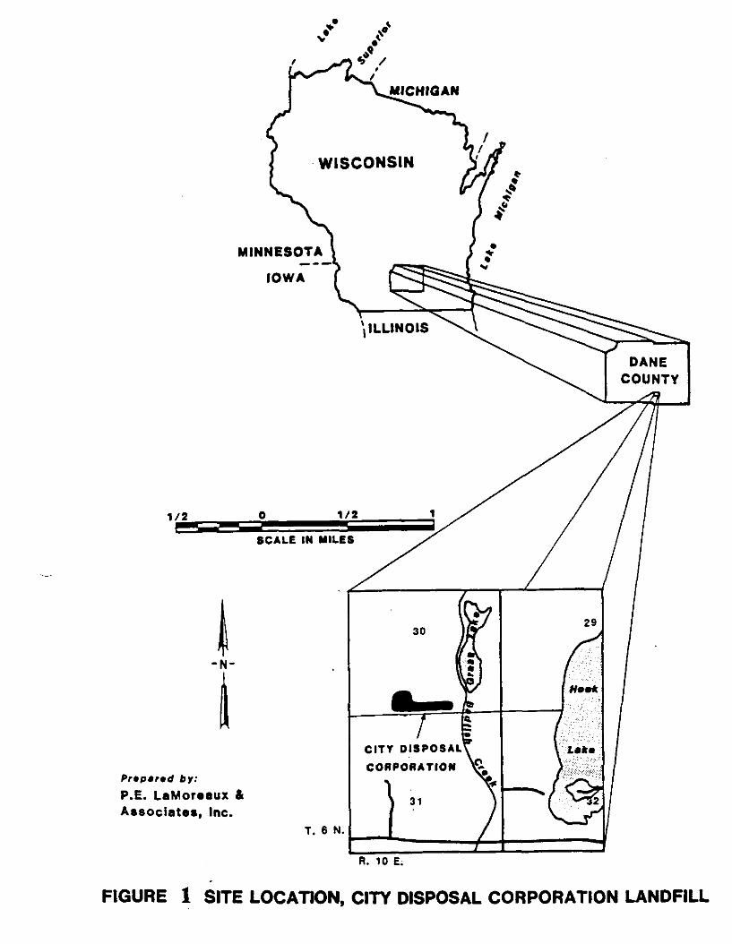
Figure 1 Site Location........................... 3
Figure 2 Sampling and Surface Water MonitoringLocations............................. 7
Table 1 Soil Cover Sample Locations............. 11
REFERENCES
APPENDIXES Appendix A - Photo LogAppendix B - Field Log
CD/toca
SECTION 1.0
INTRODUCTION
1.1 Scope of Work
At the request of the United States EnvironmentalProtection Agency, Region V (U.S. EPA), JacobsEngineering Group, Inc. (Jacobs) was issued a WorkAssignment to provide compliance monitoring of remedialinvestigation (RI) activities at the City DisposalCorporation Landfill (CDCL) of Dane, Wisconsin. Thisactivity was assigned under the Technical EnforcementSupport (TES) Contract Number 68-01-7351. Jacobssubcontracted Metcalf & Eddy, Inc. (M&E) to providethis compliance monitoring. The scope of this workconsisted of Work Plan Preparation; Evaluation orReview of All Technical Documents and Reports;Oversight of Field Work; Participation in CommunityRelations and a Pre-Feasibility Study Meeting. Thisreport was prepared in order to document field workperformed to date.
M&E provided oversight of RI activities conducted atCDCL from 14 November 1988 through 30 November 1988.M&E performed this oversight to assure compliance withthe procedures specified in the RI/FS Work Plan. Theactivities performed during this phase included:
Installation of Surface Water Monitoring GagesExisting Monitoring Well InventoryGeophysical SurveyCover Survey and Soil Sampling
These activities were performed by P.E. La Moreaux andAssociates, Inc. (PELA) of Tuscaloosa, Alabama inaccordance with the RI/FS Work Plan for CDCL preparedon behalf of Waste Management of Wisconsin, Inc.
This report provides a summary of this phase of fieldactivities at CDCL. Photographs were taken in order todocument field activities and are attached in AppendixA.
CD/c

1.2 Site Background
The CDCL is located on approximately 38 acres in thesouthern half of Section 30, Township 6 North, Range 10East in Dane County, Wisconsin (Figure 1). The sitewas first licensed and utilized in 1966 and closed inJanuary 1977. The site was operated by City DisposalCorporation and later by Acme Services, Inc. incompliance with NR 151 and licensed throughout theoperational period in accordance with prevailingregulations. Upon closure of the site both CityDisposal and Acme were acquired by Waste Management ofWisconsin, Incorporated (WMWI).
According to engineering plans completed by SoilTesting Services of Wisconsin, Inc., the landfill iscomprised of 12 cells. Cells 1,2,3,4,6 and 12 werefilled or partially filled. The remaining cells werenever utilized for landfilling purposes. Cells 1 and12 were used from 1966 to 1974. Cells 2,3,4 and 6 werefilled or partially filled from 1974 until closure in1977. Cell 12 accepted industrial wastes from 1966through March 1975. These wastes included xylene,naphtha, cyclohexanone, tetrahydrofuran, and oil-watermixtures (1).
1.3 Project Approach
The TES Contractor was requested to provide compliancemonitoring of RI/FS activities at the CDCL. M&E wassubcontracted to perform this work assignment.
A work plan was prepared which describes the effortrequired to provide contractor oversight for the CDCLproject. This work plan addressed the outline of taskscontained in U.S. EPA's Technical Statement of Work.The work plan consists of the following activities:
Preparation of Work PlanEvaluation or Review of All Technical Documentsand ReportsRemedial Investigation/Feasibility Study OversightParticipation in Community Relations and Pre-Feasibility Meeting
Each of these activities is discussed below:
Preparation of Work Plan
Upon receipt of the TES Work Assignment, a Work Planwas prepared which outlined the tasks necessary tocomplete the project.
CD/c
MINNESOTA
IOWA
CITY DISPOSAL
CORPORATION
1/2
by:P.E. LaMoreaux &Associates, Inc.
R. 10 E.
FIGURE 1 SITE LOCATION, CITY DISPOSAL CORPORATION LANDFILL
Evaluation or Review of All Technical Documents andReports
In order to apprise the TES personnel of theRespondent's efforts in development of Work, QualityAssurance, Sampling, Health and Safety Plans, EPA willsupply final versions, pertinent addenda andcorrespondence regarding such Plans. Following thecollection of the field data, the TES Contractor willreview the Respondent's Draft RI report and providecomment to the EPA. The TES Contractor will alsosupply technical review and comment of the DraftFeasibility Study submitted by the Respondents.
Remedial Investigation/Feasibility Study Oversight
M&E provided field oversight of activities at CDCL asdirected by the U.S. EPA Primary Contact. The U.S. EPAPrimary Contact requested that M&E provide compliancemonitoring during the cover survey; sampling events;surface water monitoring; existing monitoring wellinventory; installation of leachate wells, piezometers,water-table wells, and nested wells; and downholegeophysics.
This report summarizes the following activitiesperformed to date: Installation of Surface WaterMonitoring Gages; Existing Monitoring Well Inventory;Geophysical Survey; Cover Survey and Soil SampleCollection for Physical Analysis. M&E monitored thisfield work conducted at CDCL for conformance with thesampling protocols and QA/QC procedures contained inthe approved project plans.
A daily log was kept during the compliance monitoringperiod. The log included the following items:
DateActivities performed that dayActivities scheduled for next dayProblems encounteredProblem resolutionsDepartures from the Work PlanPersonnel on-siteEquipment on SiteOther relevant comments
A copy of the field log is provided as Appendix B tothis report.
M&E oversight personnel followed the personalprotection requirements which were established in thePRP's Health and Safety Plan for the project.
CD/c

Participation in Community Relations and Pre-Feasibility Meeting
The TES Contractor participated in a Kick-off meetingon 29 September 1988. This meeting was attended bypersonnel from the U.S. EPA, Wisconsin DNR, PELA, WMWIas well as concerned citizens from the community. TheTES Contractor will participate in any future communityrelation activities as requested by the U.S. EPA. APre-Feasibility Study Meeting will be held with EPA,the TES Contractor, and appropriate Staterepresentatives to discuss the direction of the FS,specific areas to be addressed, probable technologies,and possible alternatives.
CD/c

SECTION 2.0
SURFACE WATER MONITORING
2.1 Purpose
In order to assess the hydraulic relationship betweenthe surface water and ground water systems, monitoringof surface water elevations will be conductedthroughout the RI.
2.2 Monitoring Locations
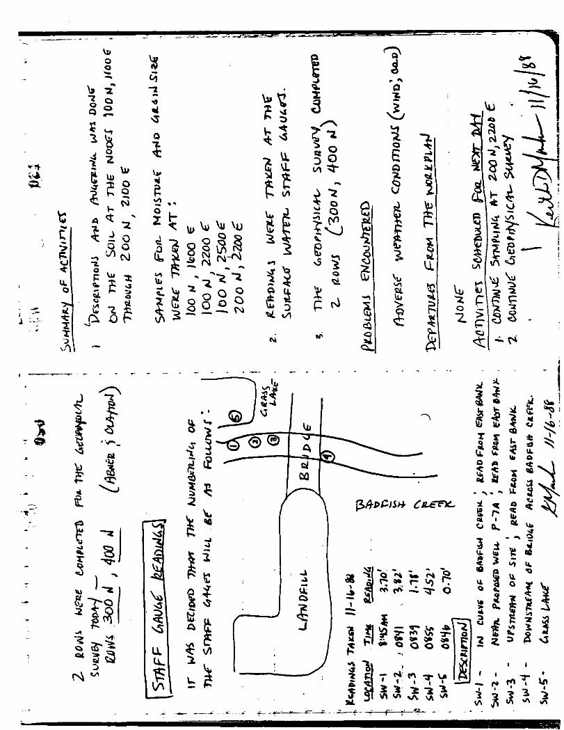
Permanent monitoring gages were installed in Grass Lakeand Badfish Creek on the eastern portion of the site.On 15 November 1988, four staff gages were installed inBadfish Creek and one staff gage was installed in GrassLake (see Figure 2). Of the gages monitoring BadfishCreek, one was placed immediately south of the bridgeand designated as SW-4; a second was placed upstream,approximately 200 ft. north of the bridge anddesignated as SW-3; a third gage located north of SW-3was already present from another investigation, and wasdesignated as SW-2; a fourth gage was installedadjacent to Grass Lake and designated as SW-1. A fifthstaff gage, SW-5, was installed in Grass Lake adjacentto Badfish Creek.
Readings were taken from the gages periodically andrecorded with the date and time. These gages will besurveyed by a licensed surveyor at a future date.
CD/c
FIGURE 2 CITY DISPOSAL CORPORATION LANDFILLSAMPLING AND SURFACE WATER MONITORING LOCATIONS
GRASS LAKE
g sw-ro.o> \\\(Qon n) A ^ v \ \* CF \J\Jj\Jr
(<
(500,0)
)
f
-—
__
— — v '
Ht^-H
-H
— ,
— <
(0,0)
• - SOIL
-H^i
M
M
Mh-
^H_»—
t—
i —V
— (
-H
-H
H-
ooino
COVER
1 ——
1 ——
— <
— <
i —
i —-ih~
— <
— <
—4
, —
> —
OOO
o
SAMPLE LOG
» — -H
-H
-H
»—
-H
( —
>—
I —
-H
— <
h—
h-
OOIO
C5
(\TIONS
— <
^
—
>—
—4
Xj
1 —
1 —
[-<
r
OOO
o
— i
( —
> —
>—
— <
SW-4
— <
>-e
f
\\
J
'//
/-
V SW-E
(900,2700)
7f SW-2
SW-3
(0,2700)
V- SURFACE WATER MONITORING GAGES
SCALE:1"=500'
BADFISH CREEK

SECTION 3.0
EXISTING MONITORING WELL INVENTORY
3.1 Purpose
An inventory of existing monitoring wells was performedin order to assess the condition of each well. Theinformation collected from the field will be comparedwith the available drilling and installationdocumentation. These data will serve as a basis fordetermining locations for sampling, well replacementand possible decommissioning of wells.
3.2 Methods
The existing wells were located and the condition ofthe protective casing, surface seal, lock and casingwere inspected and noted. Total well depth and waterlevel elevation were measured for each existingmonitoring well. This inventory was conducted on 20November 1988.
Some wells however, could not be fully inspected ormeasured as PELA was not equipped with a key. Themonitoring wells which could not be accessed were B-12R, B-14, and B-17. Therefore, only limitedinformation on their condition is available at thistime.
CD/c
SECTION 4.0
GEOPHYSICAL SURVEY
4.1 Purpose
An electromagnetic survey was performed at CDCL duringthis phase of RI field activities. This survey wasperformed in order to obtain information on subsurfaceand near surface conditions.
4.2 Methods
A grid system was established across the site fororientation and spacing of profiles. This grid wassurveyed by Landmark Surveyors of Madison, Wisconsin.It was oriented with the X-axis trending approximatelynorth-south and the Y-axis trending approximately east-west. The origin of the grid was established in thesouth-west corner of the site. Each node on the gridwas characterized by 100-foot spacings. The gridextended from ON,OE to 900N,2700E.
A Geonics Model EM34-3XL electromagnetometer (SerialNo. 8506019) was used. Electromagnetivity was measuredin the vertical and horizontal dipole mode (Serial Nos.Of Poles: RX 8506019, TX 8506019). The poles to the EMwere used at 40 meter spacings at each grid node. Abase line was established for quality assurance at800N,500E to 800N,900E. This line was chosen as thebase line due to its distance from the landfilled area.The base line was visited perodically to assureconsistency of readings. The geophysical survey wasconducted over the grid and extended further out beyondthe grid. The survey was extended further than thegrid in order to obtain background data of naturalsubsurface conditions for the area.
CD/c

SECTION 5.0
COVER SURVEY AND SOIL SAMPLING
5.1 Purpose
A soil cover survey was performed in order to assessthe composition, integrity, and thickness of theexisting soil cover. Information obtained from thesoil cover survey will also be used in developing awater budget for the site.
5.2 Methods
This survey was conducted at the nodes of the 100-footgrid system established by Landmark Surveyors. PELAused a hand auger to bore into the soil cover. Theborings were examined and documented in a field logbookby PELA. Each boring was extended until either one ofthe following occurred: garbage was encountered,extent of auger was reached (4 ft. length), or theauger was refused (due to solid subsurface materials).
Headspace of the borings was measured with an HNU or aTIP photoionization detector. Soil samples werecollected for analysis of physical parameters in orderto evaluate the permeability of the soil covermaterial. The samples will be submitted for analysisof grain size distribution, compaction, and moisturecontent.
CD/c 10

TABLE 1
SOIL COVER SAMPLE LOCATIONS
100N,100N,100N,100N,100N,100N,200N,200N,200N,200N,200N,300N,300N,300N,300N,300N,300N,400N,400N,400N,400N,400N,
400E700E1000E1600E2200E2500E400E500E1300E1800E2200EOE (1800E1300E1800E2100E2600E400E500E1200E1600E2100E
(1)(1)(1)
)
(2)(1)
(2)
SOON,SOON,500N,500N,SOON,600N,600N,600N,600N,600N,700N,700N,700N,SOON,SOON,900N,900N,900N,
400E500E1000E1700E2400EOE600E1400E1600E2000EOE500E1000E300E800E400E800E1000E
Note: All samples listed above were submitted foranalysis of grain size distribution and moisturecontent.
(1) Samples analyzed to develop compaction test curvesin addition to parameters listed above.
(2) Samples not collected due to location in cow/bullenclosure.
5.3 Cover Survey
The following is an independent summary by M&E of theborings examined at each grid node. For a morecomplete description of each boring, please refer tothe field logbook in Appendix B.
100N. OE0-3 FT Dark brown clayey soil grading into
silty clay. HNU in borehole = 0ppm above background.
CD/c 11

100N. 100E0-1.2 FT
100N. 200E0-1.5 FT
1.5-1.6 FT
100N. 300E0-1.25 FT
1.25-1.55 FT
100N, 400E0-1.2 FT
1.2-1.25 FT
100N. 500E0-0.65 FT
0.65-0.7 FT
100N. 600E0-1.2 FT
1.2-1.25 FT
Dark brown clayey soil grading intobrown silty sand and gravel. Augerrefusal. HNU in borehole = 0 ppmabove background.
Dark brown clayey soil grading intobrown silty sand and gravel gradinginto light gray clay.
Garbage encountered (plastic,paper) HNU in borehole = 0 ppmabove background.
Dark brown clayey soil grading intobrown silty sand and gravel gradinginto light gray clay.
Garbage encountered (green glass)HNU in borehole = 0 ppm abovebackground.
Dark brown clayey soil grading intobrown silty sand and gravel.
Garbage encountered (glass)HNU in borehole = 0 ppm abovebackground.
Light brown silty sandy clay.
Garbage encountered, water inborehole. HNU in borehole = 0 ppmabove background.
Light brown silty sandy claygrading into sand and gravel.
Garbage encountered.
100N, 700E————0-2.5 FT
2.5-2.65 FT
Dark brown clayey soil grading intosandy silty clay grading into grayclay.
Garbage encountered.
CD/c 12
100N. 800E0-2.0 FT
2nd Borehole0-0.9 FT
3rd Borehole0-3.1 FT
100N. 900E0-2.70 FT
100N. 1000E0-1.95 FT
2nd Borehole0-2.0 FT
2.0 FT
100N. HOPE0-2.05 FT
2.05-2.15 FT
100N. 1200E0-0.65 FT
0.65-0.75 FT
Dark brown clayey soil with sandseams grading into gray silty claywith sand and gravel. Augerrefusal.
Dark brown clayey soil grading intobrown silty sandy clay. Augerrefusal.
Dark brown clayey soil grading intosilty gray clay grading into darkgray clay. Auger refusal.
Dark brown clayey soil grading intodark brown clay with rock fragmentsgrading into light gray silty clay.Auger refusal.
Dark brown clayey soil, watersaturated, grading into brownishgray silty clay with rockfragments. Auger refusal.
Description same as above.
Garbage encountered.
Dark brown clayey soil with organicmaterial, very saturated, gradinginto light gray clay.
Garbage encountered.HNU in borehole = 0 ppm abovebackground.
Dark brown clayey soil with organicmaterial.
Garbage encountered.HNU in borehole = 0 ppm abovebackground.
CD/c 13

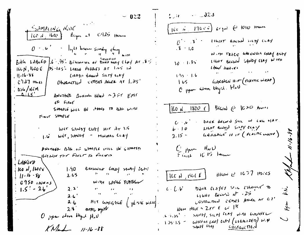
100N. 1300E0-1.8 FT
1.8-2.0 FT
100N. 1400E0-1.05 FT
1.05 FT
100N. 1500E0-1.1 FT
2nd Borehole0-0.8 FT
3rd Borehole0-0.95 FT
0.95 FT
100N. 1600E0-1.25 FT
2nd Borehole0-2.6 FT
2.6-2.8 FT
100N. 1700E0-1.6 FT
Dark brown clayey soil grading intobrownish gray silty clay with rockfragments.
Garbage encountered.HNU in borehole = 0 ppm abovebackground.
Dark brown clayey soil with organicmaterial grading into dark graysilty clay with rock fragments.
Garbage encountered.HNU in borehole - 0 ppm abovebackground.
Dark brown sandy soil grading intolight brown silty clay withweathered rock fragments gradinginto light gray silty clay. Augerrefusal.
Description same as above. Augerrefusal.
Description same as above.
Garbage encountered.HNU in borehole = 0 ppm abovebackground.
Light brown sandy clay grading intogray clay grading into grayishbrown silty clay with rockfragments. Auger refusal.
Description same as above.
Garbage encountered (plastic wrap).HNU in borehole = 0 ppm abovebackground.
Light brown silty clay grading intosandy clay with rock fragments.
CD/c 14

1.6-1.65 FT
100N. 1800E0-2.15 FT
2.15 FT
100N. 1900E0-0.7 FT
2nd Borehole0-1.5 FT
Garbage encountered (plastic wrapHNU in borehole = 0 ppm abovebackground.
Dark brown clayey soil with organicmatter grading into light brownsilty clay.
Garbage encountered.HNU in borehole = 0 ppm abovebackground.
Dark brown clayey soil grading intolight brown silty clay. Augerrefusal.
Dark brown clayey soil grading intobrown sandy silty clay with gravelgrading into gray clay. Augerrefusal.
100N. 2000E0-1.45 FT
2nd Borehole0-0.6 FT
3rd Borehole0-0.6 FT
100N. 2100E0-1.35 FT
100N. 2200E0-4.5 FT
Dark brown clayey soil with organicmatter grading into light brownclay with gravel. Auger refusal.
Same description as above. Augerrefusal.
Same description as above. Augerrefusal.
Dark brown clayey soil grading intolight brown clay with rockfragments. Auger refusal.
Dark brown clayey soil grading intolight brown and gray clay gradinginto water saturated brown claywith sand and gravel.HNU in borehole = 0.4 ppm abovebackground.
CD/c 15
100N. 2300E0-2.8 FT
100N. 2400E0-3.0 FT
100N. 2500E0-4.0 FT
200N, OE0-4.0 FT
200N, 100E0-2.2 FT
2.2 FT
200N. 200E0-2.75 FT
20ON, 300E0-1.2 FT
Dark brown clayey soil with organicmatter grading into light brownsilty sandy clay with rockfragments. Auger refusal.HNU in borehole = 0 ppm abovebackground.
Dark brown clayey soil with organicmatter grading into gray siltyclay. Auger refusal.
Dark brown clayey soil grading intolight brown clay with gravelgrading into gray silty clay withgravel.HNU in borehole = 0 ppm abovebackground.
Dark brown clayey soil with organicmatter grading into light brownsilty sandy clay grading into graysilty sandy clay.HNU in borehole = 0 ppm abovebackground.
Dark brown clayey soil grading intolight brown clay.
Garbage encountered (plastic).HNU in borehole = 0 ppm abovebackground.
Dark brown clayey soil with organicmatter grading into dark brown claywith rock fragments, grading intolight brown silty clay with rockfragments. Auger refusal.HNU in borehole = 0 ppm abovebackground.
Dark brown clayey soil with organicmatter grading into light brown andgray silty clay.
CD/c 16
1.2 FT
200N. 400E0-1.5 FT
1.5 FT
200N. 500E0-2.85 FT
200N. 600E0-0.95 FT
2nd Borehole0-0.85 FT
3rd Borehole0-2.1 FT
200N. 700E0-0.6 FT
2nd Borehole0-2.45 FT
2.45 FT
200N. 800E0-1.0 FT
2nd Borehole0-0.55 FT
Garbage encountered (fibrousinsulation).HNU in borehole = 0 ppm abovebackground.
Same general material.
Garbage encountered (plastic).HNU in borehole =0.5 ppm abovebackground.
Same general material. Augerrefusal.
Black soil with organic mattergrading into light brown clay.Auger refusal.
Same description as above. Augerrefusal.
Same description as above gradinginto gray clay with gravel. Augerrefusal.HNU in borehole = 0 ppm abovebackground.
Dark brown organic soil. Augerrefusal.
Dark brown organic soil gradinginto light brown clay with rockfragments grading into gray sandyclay.
Garbage encountered.HNU in borehole = 3 ppm abovebackground.
Dark brown clayey soil grading intolight brown sandy clay. Augerrefusal.
Same description as above. Augerrefusal.
CD/c 17

3rd Borehole:0-0.65 FT Same description as above. Auger
refusal.
4th Borehole:0-0.75 FT Same
SOON. 900E0-2.65 FT
2.65 FT
200N. 1000E0-0.95 FT
0.95-1.3 FT
200N. HOPE0-1.2 FT
1.2 FT
200N. 1200E0-1.0 FT
1.0-1.25 FT
200N. 1300E0-2.4 FT
2.4-2.5 FT
200N. 1400E0-0.8 FT
description as above. Augerrefusal.HNU in borehole = 0 ppm abovebackground.
Dark brown clay grading into lightbrown silty clay with sand gradinginto gray sandy clay.Garbage encountered (plastic).HNU in borehole = 2 ppm abovebackground.
Dark brown clayey soil grading intolight brown clay.
Garbage encountered (metal).
Dark brown clayey soil grading intolight brown sandy clay grading intolight gray silty clay.
Garbage encountered (plastic).
Dark brown organic soil gradinginto light brown sandy clay.
Garbage encountered (plastic).HNU in borehole = 0 ppm abovebackground.
Dark brown organic soil gradinginto light brown sandy clay gradinginto gray silty clay withincreasing clay content.
Garbage encountered.HNU in borehole = 0 ppm abovebackground.
Light brown clay grading into lightbrown silty clay with pebblesgrading into clay. Auger refusal.
CD/c 18

2nd Borehole
0-0.95 FT
0.95 FT
200N. 1500E0-0.7 FT
0.7 FT
200N. 1600E0-1.05 FT
2nd Borehole0-1.7 FT
1.7 FT
200N. 1700E0-2.0 FT
2.0 FT
200N. 1800E0-3.15 FT
3.15-3.45 FT
200N. 1900E0-2.6 FT
Same description as above.
Garbage encountered.
Dark brown organic soil gradinginto light brown silty sandy clay
Garbage encountered (paper).HNU in borehole = 0 ppm abovebackground.
Dark brown clayey soil grading intolight brown sandy clay with rockfragments. Auger refusal.
Same description as above gradinginto gray silty clay with red brownclay.
Garbage encountered (glass).HNU in borehole = 0 ppm abovebackground.
Same general material.
Garbage encountered (plasticsheeting).
Dark brown organic clayey soilgrading into light brown sandy claygrading into reddish brown siltyclay with pebbles grading intolight gray silty clay.
Garbage encountered (green paper).HNU in borehole = 0 ppm abovebackground.
Dark brown organic clayey soilgrading into brown clay withsandstone fragments grading intogray silty clay with pebbles.
CD/c 19

2.6 FT
200N. 2000E0-1.55 FT
2nd Borehole0-1.0 FT
200N. 2100E0-1.4 FT
2nd Borehole0-1.4 FT
Garbage encountered (plastic wrap)HNU in borehole = 0 ppm abovebackground.
Dark brown organic clayey soilgrading into brown sandy clay withpebbles. Auger refusal. HNU inborehole = 1 ppm above background.
Same description as above. Augerrefusal.HNU in borehole = 0.5 ppm abovebackground.
Dark clayey soil grading into brownclay with sandstone fragments.Auger refusal.
Same description as above. Augerrefusal.
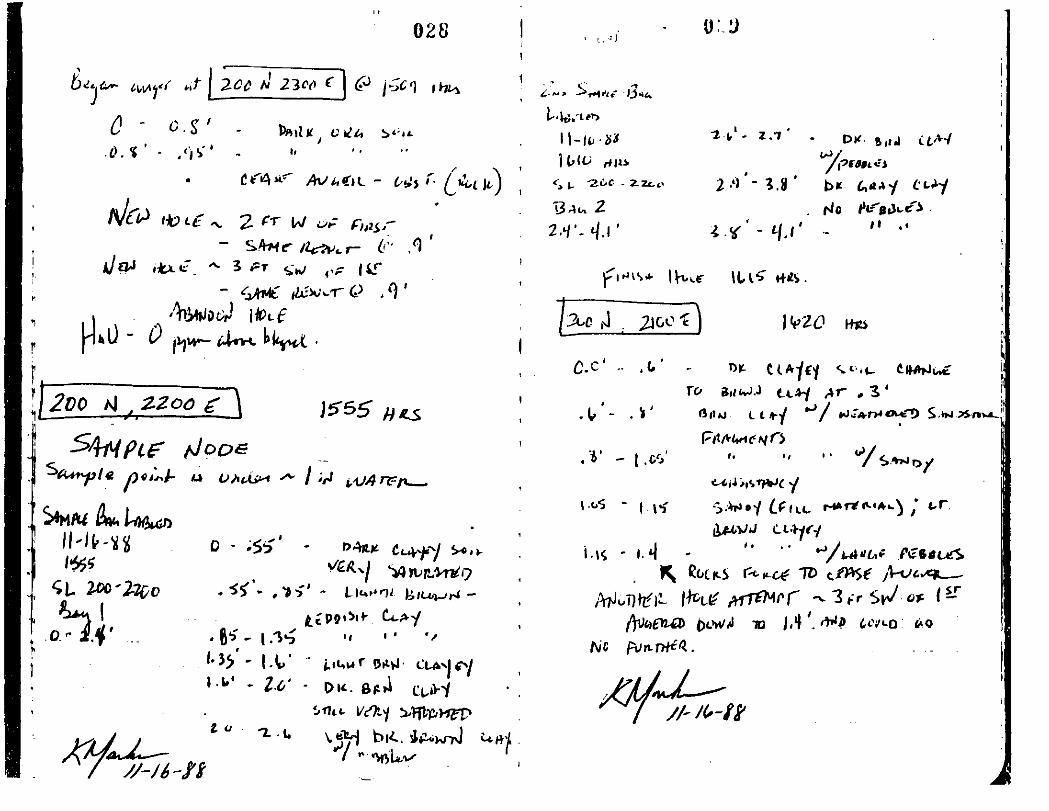
200N, 2200E0-4.1 FT
200N. 2300E0-0.95 FT
2nd Borehole0-0.9 FT
3rd Borehole0-0.9 FT
300N, OE0-2.25 FT
Dark clayey soil (water saturated)grading into light brown with redclay grading into dark brown claywith pebbles grading into gray claywith pebbles.
Dark organic soil. Auger refusal.
Dark organic soil. Auger refusal
Dark organic soil. Auger refusalHNU in borehole = 0 ppm abovebackground.
Dark brown clayey soil grading intolight brown clay with pebbles.Auger refusal.HNU in borehole = 0 ppm abovebackground.
CD/c 20

300N. 100E0-2.6 FT
2.6 FT
300N. 200E0-1.25 FT
2nd Borehole0-1.55 FT
Dark brown clayey organic soilgrading into light brown claybecoming increasingly silty withrock fragments.
Garbage encountered (fibrousinsulation).HNU in borehole = 0 ppm abovebackground.
Dark brown organic clayey soilgrading into light brown and redsandy clay. Auger refusal.HNU in borehole = 0 ppm abovebackground.
Same descriptions as above. Augerrefusal.
300N. 300E0-0.8 FT
2nd Borehole0-1.0 FT
Dark brown organic clayey soilgrading into light brown clay withrock fragments. Auger refusal.
Same description as above. Augerrefusal.
3rd Borehole0-0.4 FT Same description as above. Auger
refusal.
4th Borehole0-1.2 FT
300N. 400E0-2.6 FT
2nd Borehole0-0.6 FT
Same description as above. Augerrefusal.HNU in borehole = 0 ppm abovebackground.
Dark brown organic clayey soilgrading into light brown clay withpebbles grading into silty claywith pebbles. Auger refusal.HNU in borehole = 0 ppm abovebackground.
Same description as above. Augerrefusal.
CD/c 21
3rd Borehole0-1.0 FT Same description as above. Auger
refusal.
4th Borehole0-0.9 FT Same description as above. Auger
refusal.
5th Borehole0-1.4 FT Same description as above. Auger
refusal.
300N. 500E0-0.6 FT
2nd Borehole0-0.95 FT
300N. 600E0-0.6 FT
2nd Borehole0-0.8 FT
3rd Borehole0-0.85 FT
0.85 FT
300N. 700E0-1.3 FT
2nd Borehole0-0.9 FT
Dark brown organic clayey soil.Auger refusal.
Dark brown organic clayey soil.Auger refusal.
Dark brown organic clayey soilgrading into light brown clay withrock fragments. Auger refusal.
Same description as above gradinginto light gray sandy clay withpebbles. Auger refusal.
Same description 'as above.
Garbage encountered (plastic).HNU in borehole = 0.5 ppm abovebackground.
Dark brown organic clayey soilgrading into light brown silty claywith pebbles grading to gray siltyclay. Auger refusal.HNU in borehole = 0 ppm abovebackground.
Same description as above. Augerrefusal.
300N. 800E0-0.9 FT Dark brown organic clayey soil
grading into light brown clay.Auger refusal.
CD/c 22

2nd Borehole0-0.75 FT
3rd Borehole0-0.6 FT
300N. 900E0-1.0 FT
2nd Borehole0-2.2 FT
3rd Borehole0-0.9 FT
300N. 1000E0-1.35 FT
1.35 FT
300N. HOPE0-1.2 FT
2nd Borehole0-1.3 FT
1.3 FT
Same description as above. Augerrefusal.
Same description as above. Augerrefusal.TIP in borehole = 0 ppm abovebackground.
Dark brown organic clayey soilgrading into light brown claygrading into light brown siltysandy clay. Auger refusal.
Same description as above, moresaturated, with rock fragmentsgrading into reddish brown siltyclay. Auger refusal.
Same description as above. Augerrefusal.TIP in borehole = 0.7 ppm abovebackground.
Dark brown organic clayey soilgrading into light brown clay.
Garbage encountered (plastic andfibrous).TIP in borehole = 0 ppm abovebackground.
Dark brown organic soil gradinginto light brown clay with pebblesincreasing silt content. Augerrefusal.
Same description as above. Gradinginto gray silty clay.
Garbage encountered.TIP in borehole = 0 ppm abovebackground.
CD/c 23

300N. 1200E0-1.7 FT
1.7 FT
300N. 1300E0-4.3 FT
4.3 FT
300N. 1400E0-2.05 FT
2.05 FT
300N. 1500E0-1.5 FT
1.5-2.0 FT
300N. 1600E0-2.2 FT
2.2 FT
300N. 1700E0-1.8 FT
Dark brown organic clayey soilgrading into light brown silty claywith gray clay grading into lightbrown mottled with gray sandy siltyclay with pebbles.
Garbage encountered.TIP in borehole = 1.5-2.0 ppm abovebackground.
Dark brown organic clayey soilgrading into light brown sandy claywith pebbles grading into lightgray silty clay becomingincreasingly clayey.
Garbage encountered (newspaper).TIP in borehole = 0 ppm abovebackground.
Light brown clay becoming graysandy silty clay.
Garbage encountered.TIP in borehole = 2.5-3.0 ppm abovebackground.
Dark brown organic clayey soilgrading into light brown sandyclay.Garbage encountered (plasticpaper).TIP in borehole = 0.6-0.9 ppm abovebackground.
Dark brown organic clayey soilgrading into light brown sandy claygrading into dark gray sandy clay.
Waste Mulch encountered.TIP in borehole = 1 ppm abovebackground.
Dark brown organic clayey soilgrading into light brown clay withpebbles. Auger refusal.TIP in borehole = 0 ppm abovebackground.
CD/c 24

2nd Borehole0-1.4 FT
3rd Borehole0-2.0 FT
2.0 FT
300N. 1800E0-1.05 FT
2nd Borehole0-1.15 FT
1.15 FT
300N. 1900E0-1.35 FT
1.35 FT
300N. 2000E0-1.2 FT
1.2 FT
300N. 2100E0-0.9 FT
2nd Borehole0-0.8 FT
Same description as above. Augerrefusal.
Same description as above gradinginto gray silty clay with pebbles.
Garbage encountered (PVC).TIP in borehole = 1.8-2.3 ppm abovebackground.
Dark brown organic clayey soilgrading into light brown clay.Auger refusal.
Same description as above.
Garbage encountered (plastic).TIP in borehole - 0 ppm abovebackground.
Light brown organic clay gradinginto gray sandy clay with gravel
Garbage encountered (paper).TIP in borehole = 7-8 ppm abovebackground.
Dark brown organic clay gradinginto light brown clay with pebbles
Garbage encountered (styrofoam).TIP in borehole = 4-4.5 ppm abovebackground.
Light brown organic clayey soilgrading into light brown sandyclay. Auger refusal.
Same description as above. Augerrefusal.TIP in borehole = 1 ppm abovebackground.
CD/c 25

400N. OE0-0.65 FT
2nd Borehole0-1.0 FT
3rd Borehole0-1.7 FT
400N. 100E0-1.05 FT
400N. 200E0-1.3 FT
400N. 300E0-0.95 FT
2nd Borehole0-2.4 FT
400N. 4QOE0-1.05 FT
2nd Borehole0-0.5 FT
3rd Borehole0-1.0 FT
Brown silty clay. Auger refusal.
Brown silty clay grading into sandysilty clay. Auger refusal.
Same description as above. Augerrefusal.HNU in borehole - 0 ppm abovebackground.
Brown clayey sand. Auger refusal.Three additional boreholesattempted, auger refused.HNU in borehole = 0 ppm abovebackground.
Same general material. Augerrefusal. Two additional boreholesattempted, auger refusal.HNU in borehole - 0 ppm abovebackground.
Dark brown organic silty claygrading into brown silty claygrading into sandy, silty clay.Auger refusal.
Same description as above gradinginto gray and brown moist siltyclay. Auger refusal.HNU in borehole = 0 ppm abovebackground.
Brown silty clay grading into brownsilty sand. Auger refusal.
Brown silty clay. Auger refusal.
Same description as above gradinginto gray and brown sand andgravel. Auger refusal.HNU in borehole = 0 ppm abovebackground.
CD/c 26

400N. 500E0-1.25 FT
2nd Borehole0-1.1 FT
Brown silty clay grading intoorange-brown silty clay gradinginto light brown and gray siltyclay grading into gray sandysilty clay. Auger refusal.
Same description as above. Augerrefusal.
3rd Borehole0-0.9 FT
400N. 600E0-2.2 FT
2.2 FT
400N. 700E0-1.1 FT
1.1 FT
400N. 800E0-1.3 FT
1.3 FT
400N, 900E0-1.0 FT
1.0 FT
Same description as above. Augerrefusal.
HNU in borehole = 0 ppm abovebackground.
Brown silty clay grading into graysandy silty clay with gravel.
Garbage encountered (burnedrefuse).HNU in borehole = 2.0 ppm abovebackground.
Brown silty clay grading into brownsand and gravel grading into blackwoody material grading into brownsand and gravel.
Garbage encountered (plastic).HNU in borehole = 0 ppm abovebackground.
Brown silty clay.
Garbage encountered (plastic).HNU in borehole = 0 ppm abovebackground.
Brown silty clay grading into graysilty clay.
Garbage encountered (tire).
CD/c 27

400N. 1000E0-1.0 FT
1.0 FT
400N. HOPE0-0.8 FT
2nd Borehole0-0.75 FT
3rd Borehole0-0.8 FT
4th Borehole0-0.9 FT
0.9 FT
400N. 1200E0-0.6 FT
2nd Borehole0-0.55 FT
0.55-0.8 FT
400N. 1300E0-2.5 FT
2.5-2.6 FT
Brown silty clay with brownishorange
silty clay grading into gray siltyclay.
Garbage encountered (Tin can)HNU in borehole =0.6 ppm abovebackground.
Brown silty clay. Auger refusal
Brown silty clay. Auger refusal
Brown silty clay grading into brownsandy silty clay. Auger refusal.
Brown silty clay.
Small glass fragments - possiblygarbage. Auger refusal.TIP in borehole = 0.7 ppm abovebackground.
Dark brown clayey soil grading intolight brown silty clay grading intosandy gray clay. Auger refusal.
Same description as above.
Garbage encountered (plastic).TIP in borehole - 0 ppm abovebackground.
Dark brown organic clayey soilgrading into light brown sandy claygrading into dark gray silty claywith gravel.
Garbage encountered (plastic).TIP in borehole = 10.5 - 11.0 ppmabove background.
CD/c 28

400N. 1400E0-1.25 FT
1.25 FT
400N. 1500E0-0.65 FT
2nd Borehole0-0.5 FT
0.5-0.8 FT
400N. 1600E0-0.35 FT
2nd Borehole0-0.45 FT
3rd Borehole0-0.45 FT
400N. 1700E
400N. 1800E
400N. 1900E
SOON. 05E
Dark brown organic clayey soilgrading into reddish brown siltyclay with gravel grading into grayclay.
Garbage encountered (plastic).TIP in borehole = 0 ppm abovebackground.
Dark brown clayey soil with gravelAuger refusal.
Dark brown clayey soil with gravel
Garbage encountered (plastic).TIP in borehole = 0.6 ppm abovebackground.
Dark brown organic clay withgravel. Auger refusal.
Same description as above. Augerrefusal.
Same description as above. Augerrefusal.TIP in borehole = 0 ppm abovebackground.
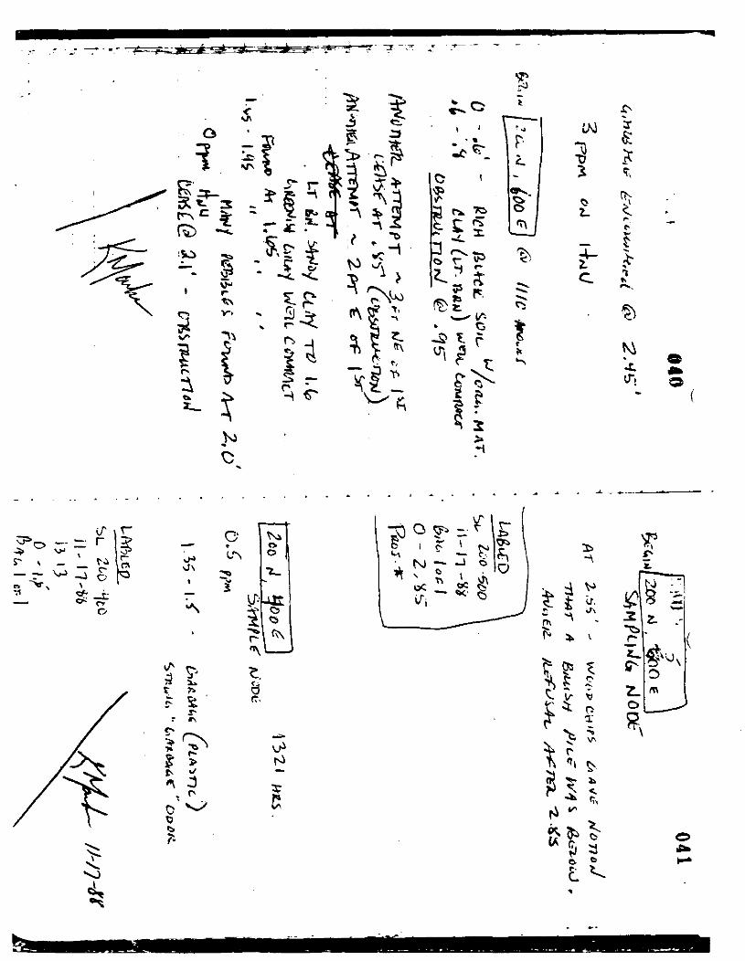
Node could not be augered due tolarge amount of rocks and gravel inthis area.
Node could not be augered due tolarge amount rocks and gravel inthis area.
Node could not be augered due tolarge amount of rocks and gravel inthis area.
Rock pile at SOON, OE prohibitedaugering on the node.
CD/c 29

0-4.1 FT Black organic soil grading intosandy silty clay with tree rootsgrading into reddish brown sandysitly clay.
SOON, 100E0-0.9 FT Black organic soil grading into
brown silty clay with sand andgravel. Auger refusal.
2nd Borehole:0-0.8 FT Same description as above. Auger
refusal.
3rd Borehole:0-0.8 FT Same description as above. Auger
refusal.
CD/c 30

4th Borehole0-0.65 FT
SOON. 200E0-1.45 FT
2nd Borehole0-1.2 FT
3rd Borehole0-1.25 FT
SOON. 300E0-1.1 FT
1.1 FT
SOON. 400E0-1.3 FT
2nd Borehole0-1.5 FT
SOON. 500E0-0.5 FT
2nd Borehole0-1.2 FT
1.2-1.35 FT
Same description as above. Augerrefusal.
HNU in borehole = 0 ppm abovebackground.
Black organic silty clay gradinginto brown silty clay with sand andgravel. Auger refusal.
Same description as above. Augerrefusal.
Same description as above. Augerrefusal.HNU in borehole = 0 ppm abovebackground.
Brown silty clay with sand andgravel.
Garbage encountered (plastic).HNU in borehole = 0 ppm abovebackground.
Black organic soil grading intobrown silty clay with rootlets androck fragments. Auger refusal.
Same description as above. Augerrefusal.HNU in borehole = 0 ppm abovebackground.
Dark brown clayey soil. Augerrefusal.
Dark brown clayey soil grading intobrown silty clay.
Garbage encountered (burntmaterial).HNU in borehole = 0 ppm abovebackground.
CD/c 31
SOON. 600E0-0.75 FT
2nd Borehole0-0.65 FT
3rd Borehole0-0.8 FT
4th Borehole0-0.85 FT
SOON. 7QOE0-1.1 FT
1.1 FT
SOON. 800E
0-0.6 FT
2nd Borehole0-1.65 FT
1.65 FT
SOON. 900E0-2.25 FT
2.25 FT
500N.1000E0-0.4 FT
0.4-0.5 FT
500K. HOPE0-4.2 FT
Brown silty clay. Auger refusal.
Brown silty clay. Auger refusal
Brown silty clay. Auger refusal
Brown silty clay. Auger refusalHNU in borehole - 0 ppm abovebackground.
Brown silty clay grading into blacksilty clay.
Garbage encountered (plastic).
Black clayey organic soil. Augerrefused.
Silty brown organic clay.Garbage encountered (white fibrousmaterial).
Brown silty clay.Garbage encountered (plastic).in borehole = 0.5 ppm abovebackground.
TIP
Brown silty clay with gray siltyclay.Garbage encountered (string,plastic, glass). TIP in borehole =O ppm above background.
Brown silty clay becomingincreasingly moist with depth,in borehole = O ppm abovebackground.
TIP
CD/c 32
SOON. 1200E0-4.2 FT
SOON. 1300E0-4.0 FT
SOON. 1400E0-4.05 FT
SOON. 1500E0-4.0 FT
SOON. 1600E0-1.3 FT
500. 1700E0-1.5 FT
2nd Borehole0-4.05 FT
SOON. 1800E0-1.05 FT
Brown silty clay grading into darkbrown silty clay grading into grayclay. TIP in borehole =0.4 ppmabove background.
Dark brown silty clay grading intobrown clayey silt grading into graysilty clay. TIP in borehole = 0.4ppm above background.
Brown silty clay grading into graysilty clay grading into black siltyclay becoming gray silty clay. TIPin borehole = 0.5 ppm abovebackground.
Same general material. TIP inborehole = 0 ppm above background.
Brown silty clay grading into sandand gravel. Auger refusal. TIP inborehole = 0 ppm above background.q
Brown clayey silt. Auger refusal
Brown clayey silt with gravel.TIP in borehole =0.5 ppm abovebackground.
Dark brown silty clay. Augerrefusal.
2nd Borehole0-1.3 FT
3rd Borehole0-4.0 FT
Dark brown silty clay. Augerrefusal.
Dark brown silty clay grading intobrown silty clay.HNU in borehole = 2 ppm abovebackground.
CD/c 33
SOON. 1900E0-4.15 FT
SOON. 20QE0-4.15 FT
SOON. 2100E0-2.9 FT
SOON. 2200E0-4.0 FT
SOON. 2300E0-4.0 FT
SOON. 2400E0-4.25 FT
600N. OE0-2.4 FT
2.4 FT
600N. 100E0-1.0 FT
Plowed soil grading into dark brownsilty clayey soil grading into grayweathered clay.HNU in borehole = 0 ppm abovebackground.
Plowed soil grading into gray clayHNU in borehole = 0 ppm abovebackground.
Plowed soil grading into gray clayAuger refusal.HNU in borehole = 0 ppm abovebackground.
Plowed soil grading into gray clayand tan clay.HNU in borehole = 0 ppm abovebackground.
Plowed soil grading into gray clayand tan clay.HNU in borehole - 0 ppm abovebackground.
Plowed soil grading into gray clayand tan clay.HNU in borehole = 0 ppm abovebackground.
Brown silty clay.
Garbage encountered.HNU in borehole = 0 ppm abovebackground.
Brown silty clay. Auger refusal.Two more boreholes attempted, augerwas refused,HNU in borehole = 0 ppm abovebackground.
CD/c 34

600N. 200E0-1.05 FT Brown silty clay. Auger refusal.
2nd Borehole:0-1.7 FT Dark brown soil grading into brown
silty clay grading into brown withgray silty clay. Auger refusal.
3rd Borehole:0-0.7 FT Same description as above. Auger
refusal.
4th Borehole:0-0.7 FT Same description as above. Auger
refusal.
600N. 300E0-1.3 FT Brown silty clay.
1.3-1.5 FT Garbage encountered.HNU in borehole = 0 ppm abovebackground.
600N. 400E0-1.2 FT Dark brown soil grading into brown
silty clay. Auger refusal.
2nd Borehole:0-1.4 FT Dark brown soil grading into brown
sandy clay.
1.4-1.7 FT Garbage encountered (paper andplastic).HNU in borehole = 0 ppm abovebackground.
600N. 500E0-1.3 FT Dark brown soil grading into brown
sandy clay. Auger refusal.
2nd Borehole:0-2.7 FT Dark brown soil grading into brown
sandy clay grading into gray siltyclay. Auger refusal.
3rd Borehole:0-1.85 FT Same description as above. Auger
refusal.
4th Borehole:0-1.8 FT Same description as above. Auger
refusal.HNU in borehole = 0 ppm abovebackground.
CD/c 35

600N. 600E0-1.65 FT Brown clay trace silt. Auger
refusal.
2nd Borehole0-2.95 FT
600N. 700E0-3.85 FT
600N. 800E0-0.95 FT
Brown silty clay with sand andgravel. Auger refusal.HNU in borehole = 0 ppm abovebackground.
Gray and brown silty clay gradinginto brown silty sand and gravelgrading into brown silty clay withsand and gravel.HNU in borehole = 2 ppm (at 3.2 FTdepth) and 0.5 ppm abovebackground.
Reddish brown silty clay. Augerrefusal.
2nd Borehole0-3.1 FT
4600N*» 900E'0-0.8 FT
SOON. 1000E0-4 FT
SOON. HOPE0-4 FT
GOON. 1200E0-4 FT
Reddish brown silty clay with sandypebbles. Auger refusal.HNU in borehole = 0 ppm abovebackground.
Brown silty clay. Auger refusal.Seven additional boreholesattempted, auger refusal.HNU in borehole = 0 ppm abovebackground.
Brown silty clay.HNU in borehole =background.
0 ppm above
Brown silty clay.HNU in borehole = 0 ppm abovebackground.
Brown silty clay.HNU in borehole =background.
0 ppm above
CD/c 36
600N. 1300E0-4 FT
600N, 1400E0-4.1 FT
600N. 1500E0-4.2 FT
SOON. 1600E0-4.05 FT
SOON. 1700E0-4.05 FT
SOON. 1800E0-1.05 FT
2nd Borehole0-1.5 FT
3rd Borehole0-0.85 FT
600N. 1900E0-4.05 FT
Brown silty clay.HNU in borehole =background.
0 ppm above
Dark brown soil grading into redbrown sandy silty clay grading intogray sandy silty clay.HNU in borehole = 0 ppm abovebackground.
Dark brown silty clay grading intobrown and gray silty clay.HNU in borehole = 0 ppm abovebackground.
Dark brown silty soil grading intotan and gray silty clay gradinginto light brown silty sand.HNU in borehole = 0 ppm abovebackground.
Dark brown soil grading intoreddish brown sand grading intoreddish brown sand with clay andsilt.HNU in borehole - 0 ppm abovebackground.
Dark brown soil grading into redbrown sand and silty clay. Augerrefusal.
Same description as above. Augerrefusal.
Same description as above. Augerrefusal.HNU in borehole - 0 ppm abovebackground.
Dark brown silty clay grading intobrown sandy silty clay grading intobrown clay.HNU in borehole = 0 ppm abovebackground.
CD/c 37

600N. 2000E0-1.25 FT
2nd Borehole0-0.9 FT
Dark clayey soil grading into brownsilty clay grading into light brownsandy silty clay. Auger refusal.
Same description as above. Augerrefusal.
3rd Borehole0-2.85 FT
TOON. OE0-2.5 FT
2nd Borehole0-1 FT
Same description as above. Augerrefusal.HNU in borehole = 0 ppm abovebackground.
Brown silty clay grading into moistbrown silty clay. Auger refusal.
Same description as above. Augerrefusal.
3rd Borehole0-4.0 FT
700N. 100E0-1.7 FT
1.7 FT
700N. 200E0-2 FT
2nd Borehole0-2 FT
3rd Borehole0-2.6 FT
2.6-2.8 FT
Same description as above. Augerrefusal.HNU in borehole = 0 ppm abovebackground.
Dark brown silty soil grading intobrown silty clay.
Garbage encountered (paper).HNU in borehole = 4 ppm abovebackground (peak).
Brown silty clay grading into brownsandy silt. Auger refusal.
Same description as above. Augerrefusal.
Same description as above. Augerrefusal.
Garbage encountered.HNU in borehole = 8 ppm abovebackground.
CD/c 38
700N, 300E0-1.45 FT
2nd Borehole0-3.2 FT
3rd Borehole0-1.0 FT
4th Borehole0-1.2 FT
700N. 40QE0-1.45 FT
2nd Borehole0-1.65 FT
3rd Borehole0-1.95 FT
1.95-2.0 FT
700N. 500E0-1.65 FT
2nd Borehole0-1.7 FT
3rd Borehole0-2.0 FT
700N. 600E0-1.0 FT
2nd Borehole0-0.8 FT
Brown silty clay. Auger refusal
Brown silty clay. Auger refusal
Brown silty clay. Auger refusal
Brown silty clay. Auger refusalHNU in borehole = 0 ppm abovebackground.
Brown silty clay. Auger refusal
Brown silty sandy clay withincreasing gravel content withdepth grading into gray and brownsilty clay. Auger refusal.
Brown silty clay grading into graysilty clay.
Garbage encountered.HNU in borehole = 1.4 ppm abovebackground.
Brown sandy clayey silt gradinginto brown silty sand. Augerrefusal.
Brown silty clay grading into brownsandy silt. Auger refusal.
Same description as above. Augerrefusal.HNU in borehole - 0 ppm abovebackground.
Brown silty clay. Auger refusal.
Brown silty clay. Auger refusal.
CD/c 39
3rd Borehole0-0.85 FT
700N. 700E0-3.25 FT
700N. 800E0-3.65 FT
700N. 900E0-4.0 FT
700N. 1000E0-3.4 FT
700N. HOPE0-3.8 FT
TOON. 1200E0-3.2 FT
SOON. OE0-1.1 FT
2nd Borehole0-1.7 FT
1.7 FT
Brown silty clay. Auger refusal.HNU in borehole - 0 ppm abovebackground.
Brown silty clay grading into brownand gray silty clay. Augerrefusal.HNU in borehole = 0 ppm abovebackground.
Brown clayey sand grading intobrown and gray sandy clay gradinginto yellow brown clayey sand.HNU in borehole = 0 ppm abovebackground.
Brown silty clay.HNU in borehole = 0 ppm abovebackground.
Brown silty clay.HNU in borehole = 0 ppm abovebackground.
Brown silty clay.HNU in borehole = 0 ppm abovebackground.
Brown silty clay.HNU in borehole = 0 ppm abovebackground.
Dark brown soil grading into brownsilty clay. Auger refusal.
Dark brown soil grading into brownsandy clay with gravel grading intogray and brown sandy clay.
Garbage encountered (paper).TIP in borehole = 1.0-1.3 ppm abovebackground.
CD/c 40
SOON. 100E0-2.2 FT
2.2 FT
SOON. 200E0-1.3 FT
SOON. 300E0-2.0 FT
2.0 FT
SOON, 400E0-3.4 FT
SOON. 500E0-2.1 FT
2nd Borehole0-2.1 FT
3rd Borehole0-2.1 FT
SOON. 600E0-1.1 FT
2nd Borehole0-1.5 FT
Dark brown soil grading into brownclayey sand.
Garbage encountered.TIP in borehole - 0 ppm abovebackground.
Brown clayey silt. Auger refusal.Two additional borehole attempts,auger refusal.TIP in borehole = 0 ppm abovebackground.
Brown clayey silt.
Garbage encountered (paper).TIP in borehole = 280-425 ppm abovebackground.
Brown silty clay.TIP in borehole = 0 ppm abovebackground.
Brown silty clay grading into grayand brown silty clay with pebbles.Auger refusal.
Brown silty clay with pebblesAuger refusal.
Brown silty clay with pebblesAuger refusal.TIP in borehole = 0 ppm abovebackground.
Brown silty clay with pebblesAuger refusal.
Brown silty clay with pebblesAuger refusal.TIP in borehole = 0 ppm abovebackground.
CD/c 41
SOON. 700E0-0.25 FT
2nd Borehole0-0.8 FT
3rd Borehole0-1.8 FT
SOON. 800E0-4.0 FT
SOON. 900E0-4.0 FT
SOON. 1000E0-4.0 FT
SOON. HOPE0-0.65 FT
2nd Borehole0-1.05 FT
3rd Borehole0-1.6 FT
SOON. 1200E0-2.8 FT
900N. OE0-1.05 FT
Dark brown soil. Auger refusal.
Brown clayey silt. Auger refusal.
Brown silty clay. Auger refusalTIP in borehole = 0 ppm abovebackground.
Yellow brown clayey silt.TIP in borehole = 0 ppm abovebackground.
Light brown silty clay.TIP in borehole = 0 ppm abovebackground.
Brown silty clay.TIP in borehole = 0 ppm abovebackground.
Brown silty clay. Auger refusal
Brown silty clay with reddishstaining. Auger refusal.
Dark brown silty clay grading intolight brown silty sand. Augerrefusal.TIP in borehole = 0 ppm abovebackground.
Dark brown soil grading into brownsilty clayey sand grading intolight brown silty sand and gravel.TIP in borehole - 0 ppm abovebackground.
Dark brown clayey silty sand.Auger refusal.
CD/c 42

2nd Borehole0-3.2 FT
900N. 100E0-1.0 FT
900N. 200E0-1.1 FT
900N. 300E0-4.1 FT
900N. 400E0-4.0 FT
900N. 500E0-4.1 FT
900N. 600E0-0.85 FT
2nd Borehole0-0.5 FT
3rd Borehole0-0.75 FT
Brown sand.TIP in borehole =background.
0 ppm above
Brown silty clay. Auger refusal.One additional borehole attempted,auger was refused.TIP in borehole = 0 ppm abovebackground.
Brown silty clay. Auger refusal.Two additional boreholes attempted,auger was refused.TIP in borehole = 0 ppm abovebackground.
Brown silty clay.TIP in borehole = 0 ppm abovebackground.
Brown silty clay grading into grayand brown silty clay with redmottling.TIP in borehole = 0 ppm abovebackground.
Dark brown soil grading into brownsilty clay grading into brown andgray silty clay with red staining.TIP in borehole = 0 ppm abovebackground.
Dark brown silty soil. Augerrefusal.
Dark brown silty soil. Augerrefusal.
Dark brown silty soil. Augerrefusal.TIP in borehole = 0 ppm abovebackground.
CD/c 43

900N. 700E0-1.5 FT Gray and brown silty clay grading
into dark brown silty clay withdecayed organic material. Augerrefusal.
2nd Borehole0-1.2 FT Dark brown silty clay. Auger
refusal.
3rd Borehole0-3.8 FT
900N. 800E0-4.0 FT
900N. 900E0-3.95 FT
900N. 1000E0-4.0 FT
900N, HOPE0-3.85 FT
900N, 1200E0-2.6 FT
2nd Borehole0-3.0 FT
Brown and gray silty clay.TIP in borehole = 0 ppm abovebackground.
Grayish brown silty clay gradinginto dark brown silty clay withwood chips grading into gray andbrown silty clay.TIP in borehole = 0 ppm abovebackground.
Brown silty clay.TIP in borehole = 0 ppm abovebackground.
Dark brown soil grading into lightbrown silty clay.TIP in borehole = 0.5 ppm abovebackground.
Dark brown soil grading intobrown/dark brown silty clay withpebbles. Auger refusal.TIP in borehole = 0.5 ppm abovebackground.
Brown/dark brown sandy silty clayAuger refusal.
Brown/dark brown sandy silty clayAuger refusal.TIP in borehole = 1 ppm abovebackground.
CD/c 44

5.4 Soil Sampling
Soil samples were collected for analysis of physicalparameters in order to evaluate the permeability of thesoil cover material. These parameters to be measuredare grain size distribution, compaction, and moisturecontent. The node locations for soil sample collectionwere selected using a random sorting function on apersonal computer. Forty sampling points were selectedfor collection of samples and are listed in Table 1.Two samples were not collected since they were locatedin a cow/bull enclosure. Thus, thirty-eight sampleswere collected for analysis of grain size distributionand moisture content. Additional sample volume wascollected from five sampling locations for analysis todevelop compaction test curves.
Each sample collected was placed in a one-gallon sizeZiploc baggie. The baggie was labeled with permanentmarker with the sampling location, date and time ofcollection, depth of collection, and sampler'sinitials. Each sample was a representative compositeof the boring from the ground surface to the end of theboring. The sample bags were sealed and stored in thelocked trailer. The samples will be transported backto Alabama and hand delivered to the lab oratory foranalysis. For transportation, each sample will beaccompanied by a chain-of-custody form developed byPELA. The chain of custody form includes the samplelocations, the dates and times of collection, thesignature of the relinquisher plus date and time whichthe samples were relinquished. The original chain-of-custody record will accompany the samples to thelaboratory, and a copy will be retained by the fieldproject coordinator.
5.5 Decontamination
The hand auger was decontaminated in between each nodeon the grid. Decontamination procedures consisted ofwashing the auger with a bristle brush in a soapsolution of brand "Tide" and distilled water. Theauger was then allowed to air dry. The water used fordecontamination was poured into a collection tankinstalled underground beneath the decontamination pad.The decontamination water collected in this tank willbe emptied when full or at the completion of theproject. This water will be disposed of at a treatmentplant.
CD/c 45

REFERENCES
(1) Remedial Investigation/Feasibility Study Work Planfor City Disposal Corporation Landfill, Volume 1,Technical Scope of Work, P.E. La Moreaux &Associates, Inc., Tuscaloosa, Alabama, August 9,1988.
CD/c 46
APPENDIX A
PHOTO LOG
Photo No.:Facility:Location:Direction:
Photographer:Camera:
Film:Date:Time:
D
City DisposalDunn, WINorth ^K. Marks PFUJI DL-145Kodak 200 ASA11/18/880940 hrs
Geophysical Survey
Photo No.:Facility:Location:Direction:
Photographer:Camera:
Film:Date:Time:
City DisposalDunn, WIEast aK. Marks p
FUJI DL-145Kodak 200 ASA11/18/880945 hrs
Geophysical Survey,
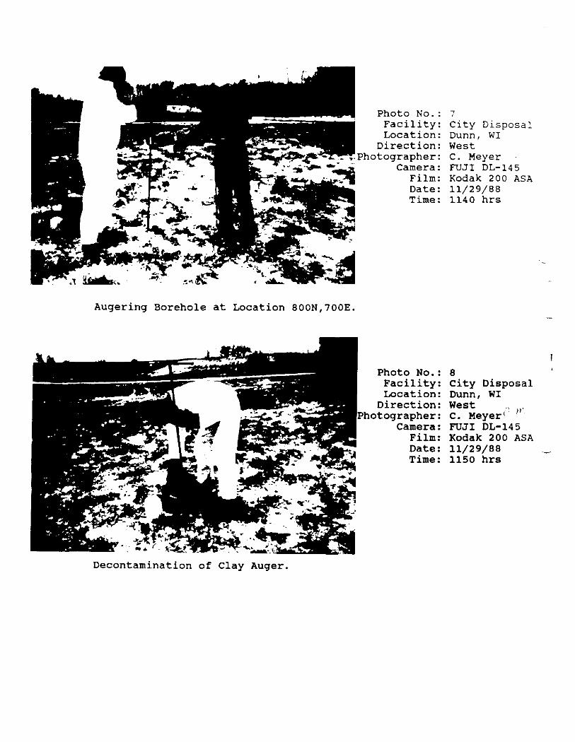
Photo No.:Facility:Location:Direction:
Photographer:Camera:
Film:Date:Time:
City DisposalDunn, WIWestC. MeyerFUJI DL-145Kodak 200 ASA11/29/881140 hrs
Augering Borehole at Location 800N,700E.
Photo No.:Facility:Location:Direction:
Photographer:Camera:Film:Date:Time:
8City DisposalDunn, WIWest .,C. Meyer( 'FUJI DL-145Kodak 200 ASA11/29/881150 hrs
Decontamination of Clay Auger.
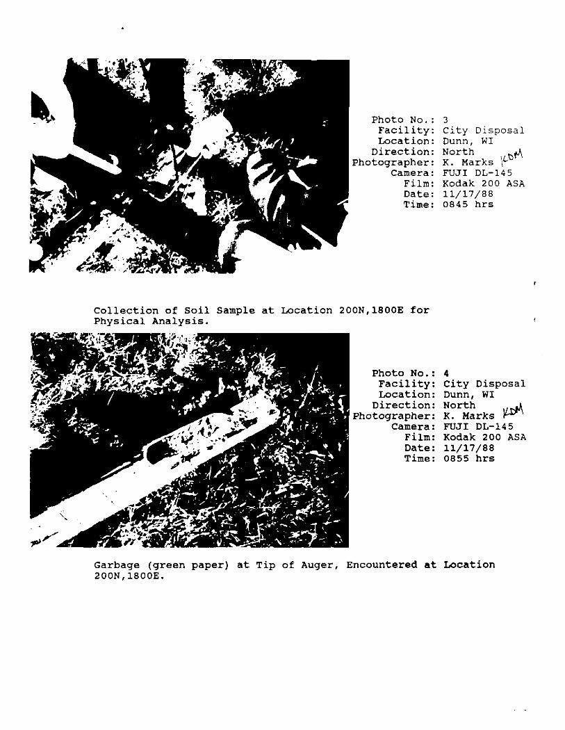
Photo No.:Facility:Location:Direction:
Photographer:Camera:
Film:Date:Time:
City DisposalDunn, WINorth *4K. Marks f^FUJI DL-145Kodak 200 ASA11/17/880845 hrs
Collection of Soil Sample at Location 200N,1800E forPhysical Analysis.
Photo No.:Facility:Location:Direction:
Photographer:Camera:Film:Date:Time:
City DisposalDunn, WINorthK. MarksFUJI DL-145Kodak 200 ASA11/17/880855 hrs
Garbage (green paper) at Tip of Auger, Encountered at Location200N,1800E.

Photo No.:Facility:Location:Direction:
Photographer:Camera:
Film:Date:Time:
City DisposalDunn, WINorthK. MarksFUJI DL-145Kodak 200 ASA11/17/880840 hrs
Boring of Landfill Cover at Location 200N/1800E.
Photo No.:Facility:Location:Direction:
Photographer:Camera:Film:Date:Tine:
City DisposalDunn, WINorthwestK. MarksFUJI DL-145Kodak 200 ASA11/17/880845 hrs
Air Monitoring in Borehole at Location 200N,1800E.
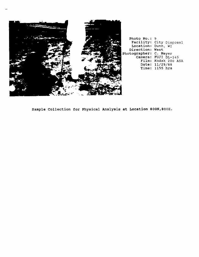
Photo NO.:FacilityLocationDirection
Photographer:Camera:
Film:Date:Time:
City DisposalDunns WIWestC. MeyerFUJI DL-145Kodak 200 ASA11/29/881155 hrs
Sample Collection for Physical Analysis at Location 800N,800E.

Development of photographs not complete at this time
CD/c 47

APPENDIX B
FIELD LOG

Ciry
v /
Memo Book • 9 IN x s% IN.Number6569657065716571 'A
Sheets48969696
RulingFaint$&«FaintFaint-Indexed
DOORUM A PEASE CO., ELIZABETH. N j
Sue P/»T7Z7,J -€ fa
torstr rv
5-
o
tetfi
o
*
0 0 *
ro
^ o
' I
C-
X - /k/50
rttt
-5 , rtfe
006
600 A/
300 £
CC6
it
KJO
//

II
AT to $p*c«ut>s
II
AT- /-
tic term
IS'*
6J,' 1.0r«_j^^
1.0 - I . V

o
ot.
-VT*-
HiVQ*
X2*rZ.
U
R Sf ?-
VA r '-i f f* 11
"V
f r *ou\
s
o*•-*c
w -^
\
f ^^ rT,^ r;
i
•A ^oi\ r*>t. r\ r-^ "p y
C -Ic.
V
>
oa Vs
- ^ Si- 06 l 1
»._, r a*v t *-
* '. O
-
1 1
2
"
r /
1J O
7 -
T"S
? ^ ^V- I'1 T~f t -r ' oc-
I'//',
loo A),
o -0,
O.t -0 -7*
II
Oils
AMr
o - O- s'S'- o. 70
7/7 V
I A> 77//C *+-'
// // r /v
O - O l ',k- .<**' '
OA5-I.'& -l.^'> |>S' -us'- i-V1-l' - a - * 'a. j ' - ^V2-u 1 - vo3-1'
7/r/t
^
4 *!
t 14
c?
co
o —
o^ Au ?-j Wil o
s!O ttf
oI.* JSI
VI
V-
1U*
o 5
& ,-*p*^ ^^ i
j To5
•xot
3 N
\^*
i;ti
£ J*1
oGt
^
I
O
4
a -
£
a u_
i- '1!
U 0 ff2 1 ^
^* r^
v, I 3
*=* Ut a
o
I
!st ^ ^i t ' *& f u>^ to %
QOC7-
v» _ v^
x C P <*V 3 vu ^ 3 Jf tvn \u 2
f * *^t J ^**

016
A
TO 77/tf-
£00 ST.
400 &
JO
017
OP A CTl^t 77
o/J r»e 5ott~/oo *J , O e
/DO n ,jOdJ, 700JOO *> ,
,-T
A
SOOO

N) _
? g
**§
I
e-
V-*
r r 0Vi-\
r x^ i*i
? H:vr*
VI
r•oX
t v>
v -;
c<_ -a
K\
00r*Ȥ5
" £5 ?
§g
3 %
N >
Tiif00
s ' $T X ^ (to
* X
w

QAtU ,
00
M^ «.
l.bS' • iU*U - / 73
' '
-' 0 »
t)1
\ 0 - U S\ 0 - 5 - » .
"7
A'w'
*
J
O .J, .>»-w I - i <
0.*
10
.isE . C
- U
>
L
|£f
ly^.- ,™ -. or

8"
£ ^<C* \f-f *_v (^
Vg
~
*sT\ —x *.t "*
IJ-r*-^
0-
- ^r ^"• n
<
r" ^
.*,
~<
r-
A
n-r t r -5 ^ i fr p ^ »' -
-„ £ J 3 i fJ f t "• I - t-

o;,t> 0' "
/
o '
^' - 30'
I
028
0
' 0
DO
4*4.1
#fo.
0 - *
/ <r1v<. - 6" ,
•
OK.
? </•-*** --"THrt*"
- z.i
. r/o
>l
-C' ,0' - Die.
To
•'*!*••/
S.i
cr
f
\9OQ
S1
^-* 1v* I*vi §^^ -J
*w A^«, c9Ro•*•
•
^ !v^
***1opQ.
J{W^
vvOO
•*•2QO
soZUJ
5H<J5tolu
£o
u/ooN
"2OO(M
•a:«az»o
*<?
f'XJ
ih*I B3T -*»•
>u§
} -*•O
3.«~n
o S"*04 sar^ ^

032
criso
.3 -l.

(11
/-; oou
U-,f|
tl'lt-ft
Q*£f i / t v *1 A*1 X
****** -
' •»*••>/'
< * ii

Jf0
O'l -
/ /»?-
( lof ,3)O~CKizi 'r' oof
J.V -l» H
5
o
- 0
9CO

u.
c -//£ -v JM3W
& A/
JY
00%
ftl
- 0
0
Z
?/.
" "
- Vf
"7**
i
, '
1 I
2H
CM £J<r,
t>c»?•-
s
v\
t.
5 a
»
L
r- •r »
-^
5s5.r
V\
"\
*£F5-3-5. '
oC
-V r^ >*r -1
10

•*•V1c
1
a 3 5rs
1 ^ 0O ' —•
». -r7: *-*4 o
^ o
c:
1o
- o
'A
-, .>• x
*
00
i
woT2:
csQ
K
^ ~~7-. jj; o
* IN
-..£-
'000$)
3 QOQ^
7 005
ool,-=7
('I

*>
cu. -
\
Af-».?
-A?C_>
0
"llw*J-orft/
(?
ML
al
/
J
J
o
- 0
-H4
J.1
55 Lff
J
oC-
TD t e"TO
/r
"*•
*!' n
- . fLT.
TV
W*-T.
70 / »
M
Tip PfApiNU
0.- x
0
.7 pp/l
I
ox Qxt, M*T.

Q
>»o
, L *( * n
/ ^
5SO
• - 0
I - t'l v«e| c\x -rr
(7
*•- f

t
o .-;•j • 0 -
1*c
>,
*-_
*
0 IP
9t*
3 1>•*•5
*"*jv

ft'
•i
I
0 • .
/./*•-/«
O
0 *- v
1.1e *i.*e 2
- 2
/p
062
@
of
(*/J /^r Jo.5
}
:'.')
O
firC>j
ow

r £64 . h Ifr-
AT T
ftooe, J
rfbc&J
, fooo e } ISQO 1 1
J33 I3.%
13;
Tt>
U-
Q
OtyiC A /A* ,
^>$
N^
^
*
1
*
^N
^%3
oTt
1fcC5
^»^^
\\&^
\J^j \
^- M- 1^ >o r1 «;N ^
^•> ^N i»
1 ' ^
N- ^'J ^ t^ • V . \f\ rv
i^s
^X^
!0«s
*
!5Nbi\
*'
^
^ A
i*r>
d i^ r-T *.
<
*
>
ri
t fi
?•^ §I
^
r-
f t ?J l il
U!r i

1.2 -l* Q.tj-O.l
0"
- 0-
- O
He* 0
0 - II
069

T''*••
a- nV L/
HO -
70
0, tO?>t
fr
' O
0 -
o - o-o* t*
J - A 3 5"1. 7 fr
\5~&)<0. O—— "" — • — ==s
0 - OJS fr
k. ,,.4
S>t ry
sat
o -
6> .
O -
f r
U < J
=- O

I ,....,,. - . . , i 1..-, 1 f\ \ \l
'I*.
tfit
TOO tft
-- ;, JA /
w
£06 j flu i>t' Clef <;># t.
A
t*J Z-tPtet,
\
O Y 5
iv
fie
Offm
57? V
0 -
/ / A

'T
K
i . I l i 076
3 CO
-O-K fAri
- 1* I *I- I * r eoS
//// ?
2
< rr
)
.77
tto^e-

r -
H
. LU/tc.
078
o
it lie fa* fat £*)<?£&
UP 04)
OO
v<W of

*7 '00
106
rife-
T IP y
080 t:u
/ 2QO&
O "
0- *•
TV- Mitt
fit/a.
It? to
a
r ,*J - O M

t
Ki i
'[m
K
- 2-
71 f
16 30/c$r^^1. /3^>^^'
- 1,0 f
082
fas j tj t v)
Q - -^ r-' /V
y-u
\IO
u83
Tlf
I- i-- o
'+-,-v-I1-
IS-
f/
•v.
0 -
085
8.
6*
tfl'TJJ

fcHJ
*:
°86
- A
t] i*J
0
r- far &&> j
' f -
3
'
f8S ?!.''
uo9
(£0 r//"£-

t - „< k :•:*
090
04% rfS
O r
- */./
o-
M U
my
092
tfd 7cs L
* Of/*1
5
0 ' 1 , u
093
•A.
Sw
*,, ! 1
l J
0 - 3-
= O€#?
**
it

094
3 5 '/; w .•" r> C d /u,
. 3? r
0 -
r;r
o .
095
r 096 097
- /.
1.3A i
0 '
/- r /. ?.7 rr
Q - j r'r
/*/
n-f '
°98
j n O-
TtoU
c> - ./-
2.I- tiff-
6-
0-nn
• •• • • i»
I*..
t - .Til-i-
O -
V
ofOf
100
<T <-,?'/)
0/ - /" 1. 7 tint 5/n//)/
O
/ /
/3
o - /. o\ o
O - 2.L2- 1 -
~ 0
S/^ry

.
102103
, 10006
Q- 3-5 sttry
} oe

"M Q z
0 r
7.7
ogs)
LOl 9UI
' -
(i
rr
-0
f"1 ^j'/in,^ /' w fW(f U h £-0

i
M 108
= O
6£*te foe- LUAJC tt
\IOQCc ~
i £,7)
109
&JT*t,T
0i.\a>frb* i -Off3 -Opt-
TlP
O
Dtt> x//7~
'A,
1 ' 0,5"
ill
6 -
t)ooti\
i »
Trt
Ceccetr
6/7*
112
0
p
TIP
114
TV
115
6oi>,
flfr* *****>*>
0-
/A/.'
fffn
Tlf 0 ffl*
is./-s
t>**r»

116 117
5oic ATM
tf /
:>•
"1 ii
1

U r-' r. E V\ A,it *3* ?? p e* tt»a ft ^ E fe *