u.s. department of transportation better utilizing ...€¦ · u.s. department of transportation...
TRANSCRIPT

U.S. Department of Transportation
BETTER UTILIZING INVESTMENTS TO LEVERAGE DEVELOPMENT
“BUILD” TRANSPORTATION DISCRETIONARY GRANTS
FY 2018 GRANT APPLICATION
Project Name: Maine Western Gateways Project
Project Type: Road Repair/Replacement
Project Location: Rural, Maine 2nd Congressional District
Funds Requested: $11,027,500 - (50%)
Funds Matched: $11,027,500 - (50%)
Total Project Cost: $22,055,000
Contact: Mr. Andrew Bickmore, Director of Results and Information
Maine Department of Transportation
16 State House Station
Augusta, ME 04333
Telephone: 207-624-3293
e-mail: [email protected]
DUNS #: 80-904-5966
Maine Western Gateways Project REBUILDING HIGHWAY ACCESS TO MAINE’S RURAL COMMUNITIES
Kingfield
Woodstock
Fryeburg

MAINE WESTERN GATEWAYS PROJECT REBUILDING HIGHWAY ACCESS TO MAINE’S RURAL COMMUNITIES
______________________________________________________________________________
2
Project Summary
Maine Department of Transportation (MaineDOT) is seeking $11,027,500 from a U.S.
Department of Transportation (USDOT) Better Utilizing Investments to Leverage Development
(BUILD) FY 2018 grant. The total cost of the project is $22,055,000, 50 percent ($11,027,500)
of which will be matched by MaineDOT.
The Maine Western Gateways Project (“Project”) will:
a) Repair, resurface, improve drainage, and strengthen sub-surfaces to a network of three key
roadways, including two National Highway System routes, through three towns in rural Maine.
b) Improve the safety of these roads for motorists, bicyclists, and pedestrians, including
schoolchildren, by modernizing design attributes and pedestrian flow.
c) Provide safe and efficient access to rural retail, commerce, employment centers, and the vital
recreation and tourism points critical to Maine’s economy.
d) Create uninterrupted supply chains for businesses in the region, including Maine’s tourism
economy as well as the industrial lumber economy.
e) Meet the Americans with Disabilities Act (ADA) standards and MaineDOT standards for
pedestrians and bicyclists regarding sidewalk, road crossing and bike lane safety.
The Project entails resurfacing and improving three roadways with numerous potholes and
rutting in rural Franklin and Oxford Counties. The Project elements are linked together in a
common objective; all three roads are pivotal routes through western Maine. Furthermore, each
portion of the Project, five miles in total, requires completion in order to finish the final segment
of longer road reconstruction projects already concluded by MaineDOT. The already completed
portions are located in the remote areas directly outside of these towns; what remains now is
making the necessary improvements through the towns. Due to historic buildings, pedestrian
walkways and parking needs, special care is required of any such road upgrade project when
performed through a historic town or municipality. As such, these projects require additional
funding to address unique challenges including: space constraints with historic buildings so close
to the right-of-way, allocation for pedestrian sidewalks and crosswalk improvements in town,
ADA compliance improvements, intersection upgrades, and driver sight-distance improvements.
The impact of poor roads and sidewalks on the residents in the region, as well as those traveling
through the region for business or to enjoy Maine’s many outdoor recreational opportunities, is
great. These roads are clustered in a rural region that relies on tourism as a primary driver of the
economy. The Project also takes into account the need to improve access to schools and basic
emergency services for residents in this rural region. These roads allow businesses in Maine to
connect to main arteries such as Interstate 95 while allowing recreational enthusiasts continued
access to Maine’s outdoor activities that drive the tourism. The roads pass through small towns,
yet on an average daily basis nearly 22,000 vehicles utilize them, including almost 1,900 heavy
trucks. The vehicle count is expected to grow to 26,000 by 2038, numbers that belie the
population of the towns themselves. Maine’s legislators as well as MaineDOT have been
investing consistently in road improvements and replacements statewide, but additional funding
sources are now required to complete these particularly complex road improvements through the
towns. They possess a need that goes beyond simply repaving. MaineDOT is an accomplished

MAINE WESTERN GATEWAYS PROJECT REBUILDING HIGHWAY ACCESS TO MAINE’S RURAL COMMUNITIES
______________________________________________________________________________
3
and responsible recipient of past TIGER, FASTLANE and INFRA grants. As such, MaineDOT
can be relied upon to fully fund and commence the Project in advance of the 2020 obligation
date and to complete the project by the 2025 requirement. Upgrading the three routes ensures
this region improves mobility and ends burdensome challenges that this rural area simply cannot
afford.
Table of Contents
I PROJECT DESCRIPTION 3
II PROJECT LOCATION 15
III GRANT FUND SOURCES/USES 16
IV MERIT CRITERIA 17
V PROJECT READINESS 23
VI FEDERAL WAGE CERTIFICATION 30
APPENDICES
Standard Form 424, Application for Federal Assistance
Project Narrative
I. Project Description
a) PROJECT DETAILS AND BACKGROUND
Of all the states in the U.S., Maine has the highest proportion of its residents living in rural areas,
some 61.3% according to the Census Bureau definition.1 In fact, 89% of the total land in Maine
is forestland.2 Maine is the most sparsely populated state east of the Mississippi with only 41.3
people per square mile.3 The three road improvement needs that combined make up the Project
are all in rural Maine in Franklin and adjacent Oxford counties. “Rural residents tend to be more
heavily reliant on their limited transportation network - primarily rural roads and highways - than
their counterparts in more urban areas. Residents of rural areas often must travel longer
distances to access education, employment, retail locations, social opportunities and health
services.”4 But the need for these road improvements stretches well beyond meeting the needs of
local residents. Maine’s multi-billion-dollar tourism industry benefits when those visiting Maine
travel on roads that are smooth, modern and safe. The roads are vital to Maine’s lumber
industry, which provides nearly 15,000 direct jobs and 34,000 total jobs statewide, but is an
industry facing recent challenges competing in a global environment. Soft demand and low
energy prices have contributed to recent wood mill closures in Maine.5 One of the roads
1 https://www.quora.com/Which-U-S-state-has-the-most-rural-land-out-of-all-the-other-states 2 http://maineforest.org/wp-content/uploads/2016/09/Maines-Forest-Economy-10-12-2016.pdf, page 2 of pdf 3 https://visitmainemediaroom.com/sites/default/files/maine-facts-2018_0.pdf 4 http://www.tripnet.org/docs/Rural_Roads_TRIP_Report_2017.pdf, page 2 5 Supra note 2, page13

MAINE WESTERN GATEWAYS PROJECT REBUILDING HIGHWAY ACCESS TO MAINE’S RURAL COMMUNITIES
______________________________________________________________________________
4
associated with the Project links Maine to Canada at a permit port of entry between the U.S. and
that country. Tourism and trade are two important ways the impacts of the Project will be felt
well beyond residents living directly along these roads. Meanwhile, local residents will benefit
as well. The roads in the Project provide residents living in Kingfield, Woodstock, Fryeburg, as
well as many other small rural towns, access to schools and shopping, health and emergency
services and basic life necessities. Each of the three towns through which the Project traverses
has a population fewer than 3,500 residents; Kingfield has fewer than 1,000. The two counties
have a population of 29,988 (Franklin County) and 57,439 (Oxford County). The roads provide
access for residents and visitors to Maine seeking state parks, lakes, beaches, ski resorts and
snowmobile trails that drive the tourism industry, which had more than 35.8 million visitors in
2016, generating nearly $6 billion in spending.6 “With an economy based largely on
manufacturing, agriculture, tourism and fishing, the quality of Maine’s transportation system
plays a vital role in the state’s economic growth and quality of life.”7 Therefore, the Project
solves a critical problem faced by rural residents in many parts of Maine: having to use outdated
roads prone to cracking and deterioration, with few safety features, sidewalks, or signage – roads
that commerce also depends upon to handle more and more cargo, including heavy truck traffic.
Thus, a road of poor quality that combines heavy truck traffic with residential traffic is a
dangerous mix. Add to the mix narrow paths of gravel acting as bicycle shoulders in many
areas, and the safety concerns intensify.
There are 23,400 miles of public highways in Maine of which MaineDOT is responsible for
8,659 of those. The roads in the Project are Highway Corridor Priority 1 (Fryeburg) and Priority
2 (Kingfield and Woodstock).
Maine has 2,361 miles of roads
in those categories, of which
771 have received an
“inadequate rating,” including
the roads in the Project. As
such, the Project roads are all
prioritized for replacement by
MaineDOT, but presently there
is not enough funding to
accomplish the work because of
higher costs associated with
improvements through towns.
“The needs of the
transportation system in Maine,
as in all other states, continue to
outpace available federal and state resources. Our state’s large land area, relatively low
population, and high number of state-jurisdiction highway miles all contribute to Maine’s
challenge. According to 2014 statistics, Maine ranks 7th in the nation in percentage of public
6 https://www.pressherald.com/2017/03/15/maine-tourism-economy-continues-growth-in-2016/ 7 http://www.tripnet.org/docs/ME_Transportation_by_the_Numbers_TRIP_Report_October_2016.pdf, page 2
From the MaineDOT Roads Report 2016 (see footnote 7, page 6)

MAINE WESTERN GATEWAYS PROJECT REBUILDING HIGHWAY ACCESS TO MAINE’S RURAL COMMUNITIES
______________________________________________________________________________
5
miles that are state responsibility. Funding per centerline mile in other northern New England
states is more than twice Maine’s funding.”8
These roads provide access to rural forestlands in Maine that are vital to the forest industry. That
industry, while in decline, is still a great driver of Maine’s economy. The industry provides
33,538 total jobs (both direct and indirect) and an $8.5 billion total economic impact to a state
with $60 billion in GDP.9 Roads provide necessary access to the region’s tourist and recreation
areas, including ski resorts, hiking trails, lakes, mountains, snowmobile trails, and beaches. The
Ski Maine Association notes
the three Project roads provide
access to the top three busiest
ski resorts in the state. The ski
resorts contribute to traffic flow
not only in the winter months.
Business conferences,
weddings, mountain biking,
and golf make the resorts a
summertime destination as
well. Maine is home to the
northernmost miles of the
Appalachian Trail, which
terminates at Mount Katahdin.
Maine is known among hikers
as having the most challenging,
rugged, remote, and wildest
feel of any area along the
famous trail. Maine’s 282
miles of the trail have some
exciting features that are rare
elsewhere on the Appalachian
Trail, including moose and
loons and pristine lakes. It's
also famous for hosting the hardest mile of the Trail: Mahoosuc Notch.10 One of only two of the
U.S. Navy’s SERE (Survival, Evasion, Resistance and Escape) Schools, a military training
facility that helps troops held captive behind enemy lines survive and cope with their capture, is
located 20 miles west of Kingfield. It is accessed via Route 27, a Project road. Opened in 1961,
the facility has trained more than 60,000 troops.11 These roads are regionally important as they
connect Maine residents with Canada and neighboring New Hampshire. They promote cross-
border commerce.
8 https://www1.maine.gov/mdot/docs/2016/roadsreport2016.pdf, page 5 9 Supra note 2, Maine Forest Economy, page 2 of pdf 10 http://www.appalachiantrail .org/home/explore-the-trail/explore-by-state/maine 11 http://www.navy.mil/submit/display.asp?story_id=68336
Ski Resorts and Appalachian Trail Map

MAINE WESTERN GATEWAYS PROJECT REBUILDING HIGHWAY ACCESS TO MAINE’S RURAL COMMUNITIES
______________________________________________________________________________
6
Quantitative Facts12
Project Name: Maine Western Gateways Project
• The $22,055,000 in roadway infrastructure investment will yield $18,446,609 in economic
output for this region (on a discounted basis).
• This project will replace three rural road surfaces, built in the 1930s and 1950s, with modern
surfaces.
• The Project has a total Net Present Value (NPV) benefit of at least $18.44 million and a
benefit-cost ratio of at least 1.05 to 1. For the purposes of this BUILD grant application, the
Benefit Cost Analysis is conservative, as it assumes no traffic growth after 20 years.
• The Project is regional in scope and is located in a rural region of the country.
• The roads in the Project are located in two counties: Franklin and Oxford.
• The Project is located in Maine’s 2nd Congressional District (Representative Poliquin). The
state is represented by U.S. Senators Susan Collins and Angus King.13
• Total Cost of the Project: $22,055,000
• Total amount of BUILD FY 2018 funds requested: $11,027,500 (50 percent of the total cost
of the project). A match has been committed by the Maine Department of Transportation in
the amount of $11,027,500 (50 percent).14
• The Project’s geospatial data can be found in a table in Project Location.
• The BCA analysis conservatively estimates that a no build scenario will lead to vehicle
crashes at current levels, continued potential for a significant flood and current levels of
maintenance.
b) CURRENT AND FUTURE CONDITIONS OF THE ROADS
Built between the 1930s and 1950s, these roads are well beyond the end of their useful lives
despite undergoing life-extending “band-aid” improvements in the past, such as top-layer road-
only resurfacing. The Project’s mission is to bring the roads up to current modern state and
federal standards, beyond simply a smooth surface. The roads need to be safer. Additionally, all
have insufficient shoulders to allow bicyclists safe passage. Most do not have today’s pedestrian
crossing safety necessities or ADA requirements to meet current standards. Periodically filling
cracks and potholes or adding a thin top layer to the road surface does not address structural
issues that have developed underneath due to age, continued upkeep of yesteryear’s asphalt
technology, and poor drainage. Each of these conditions will be remedied with surface
replacement, drainage improvements, safety upgrades, and pedestrian-suitable modernization. In
each case, road access during construction will be maintained to avoid any reroute complications
or costs. If the Project is not completed the roads will continue to deteriorate and the safety
issues will intensify. The Project roads have the combination of high needs and cost, making
them a top priority of MaineDOT, which is responsible for a majority of roads in the state.
12 See Appendix A, Benefit-Cost Analysis, for an explanation of the statistics cited below. 13 See Appendix D, Support Letters. 14 See Appendix E, Match Letter.

MAINE WESTERN GATEWAYS PROJECT REBUILDING HIGHWAY ACCESS TO MAINE’S RURAL COMMUNITIES
______________________________________________________________________________
7
Details of current road conditions, the impact of continued roadway deterioration and
replacement plans for each road in the Project follow:
I. Kingfield – Maine Route 16/27 north-south for 2.3 miles through Kingfield, ME
a) Current State
Kingfield is located on Route 27 in Franklin County. The route begins in Southport and
terminates at the U.S.-Canadian border at Coburn Gore. The southern portion of Route 27 serves
the very popular communities surrounding the Boothbay Harbor region, while the northern
portion serves ski areas. Kingfield is a mountain resort village with unique historic and cultural
Originally
Constructed
National
Highway
System
(NHS)
Highway
Corridor
Priority
(HCP)
Percentage
Trucks
5-Year
Crash
Count
2018 5,640
2038 6,7701950s
Annual Average
Daily Traffic
(AADT)
12% 272No
Photos from the Project route through Kingfield, ME (clockwise from top left) showing timber truck traffic through the rural town, deteriorated sidewalks in downtown and soft shoulders inhibiting safe vehicle pull off and bicycle access.

MAINE WESTERN GATEWAYS PROJECT REBUILDING HIGHWAY ACCESS TO MAINE’S RURAL COMMUNITIES
______________________________________________________________________________
8
qualities. It is on the Maine Scenic Byways route, a route rich with scenic beauty for tourists,
especially in the fall when the trees display their vibrant fall colors. The largest ski area in
eastern Maine, Sugarloaf Ski Resort, is on this route. The very popular resort is built on the
second highest summit in Maine and hosts 350,000 skiers annually.15 Kingfield is also home to
the Ski Museum of Maine, honoring the importance the winter sport plays in the state. The
Kingfield area and the broader Carrabassett Valley is a destination for a variety of hiking trail
enthusiasts; the Appalachian Trail traverses a number of the 4,000-foot mountain ranges in the
area. Mountain bike trails and wilderness preserves abound. The Maine Huts and Trails System,
a series of huts for hikers, bikers, and cross-country skiers in the area, offers affordable lodging
and food along many outdoor enthusiast’s various pathways. Kingfield is also home to a Poland
Springs Water bottling plant, which is the 20th largest employer and 4th largest manufacturer in
the county. Route 27 is also an important international commerce route. Located at the north
end of the route is a permit port of entry between the U.S. and Canada, established by the
Canadian government. This is also known as the Coburn Gore (U.S.-side) – Woburn (Canadian-
side) Border Crossing. The primary commerce use of this crossing is by truckers for log
products destined to Fontaine Lumber in Woburn, QC and to Stratton Lumber in Stratton,
ME. Also, wood chips are delivered to Stratton Energy, the 48-megawatt biomass electric
generating plant in Stratton. Trucks carrying “quick lime” from Quebec to the paper mills in
Rumford, Livermore, and Skowhegan also depend on this pathway. Recently there has been a
noticeable uptick in the number of passenger vehicles passing through the port, according to
customs personnel. The port is on the most direct route from Montréal and Sherbrooke, QC, to
Maine and the Maritimes. This trend is expected to continue.
The Project will address the road’s numerous potholes, rutting, and weak side slopes. Outdated
pedestrian signage, or none at all, makes the mix of pedestrians and heavy truck traffic a danger.
The road suffers from poor drainage and outdated guardrails attempting to protect drivers from
the Carrabassett River.
b) Description of Roadway Replacement
The Project plan calls for improving the safety and functionality of Route 27 through the town of
Kingfield. There are three distinct segments:
1. 25 mph - Downtown Historic
2. 30 mph - Commercial/Residential
3. 45 mph – Rural
Construction will provide a consistent 11-foot travel lane in each direction along with 5-foot
paved shoulders. In addition, sidewalks will be rebuilt to a 5-foot width and include provisions
for meeting ADA standards. Sidewalks will also be extended to make better connections
throughout the downtown. The drainage infrastructure will be rebuilt as well. Rectangular
Rapid Flashing Beacons may be utilized to better identify pedestrian crossings at mid-block
crosswalks. On-street parking will be defined in a better manner. Beyond the downtown
15 http://mountainvertical.com/best-skiing-in-new-england.php
MAINE WESTERN GATEWAYS PROJECT REBUILDING HIGHWAY ACCESS TO MAINE’S RURAL COMMUNITIES
______________________________________________________________________________
9
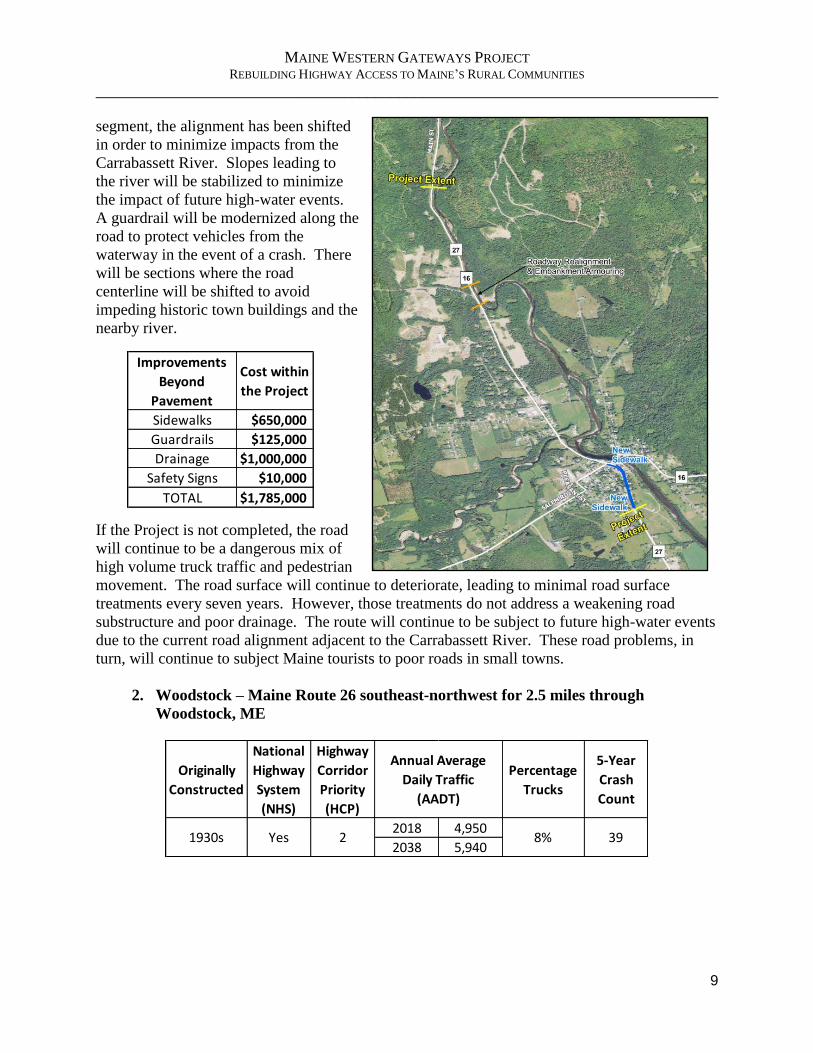
segment, the alignment has been shifted
in order to minimize impacts from the
Carrabassett River. Slopes leading to
the river will be stabilized to minimize
the impact of future high-water events.
A guardrail will be modernized along the
road to protect vehicles from the
waterway in the event of a crash. There
will be sections where the road
centerline will be shifted to avoid
impeding historic town buildings and the
nearby river.
If the Project is not completed, the road
will continue to be a dangerous mix of
high volume truck traffic and pedestrian
movement. The road surface will continue to deteriorate, leading to minimal road surface
treatments every seven years. However, those treatments do not address a weakening road
substructure and poor drainage. The route will continue to be subject to future high-water events
due to the current road alignment adjacent to the Carrabassett River. These road problems, in
turn, will continue to subject Maine tourists to poor roads in small towns.
2. Woodstock – Maine Route 26 southeast-northwest for 2.5 miles through
Woodstock, ME
Originally
Constructed
National
Highway
System
(NHS)
Highway
Corridor
Priority
(HCP)
Percentage
Trucks
5-Year
Crash
Count
2018 4,950
2038 5,9401930s
Annual Average
Daily Traffic
(AADT)
8% 392Yes
Improvements
Beyond
Pavement
Cost within
the Project
Sidewalks $650,000
Guardrails $125,000
Drainage $1,000,000
Safety Signs $10,000
TOTAL $1,785,000

MAINE WESTERN GATEWAYS PROJECT REBUILDING HIGHWAY ACCESS TO MAINE’S RURAL COMMUNITIES
______________________________________________________________________________
10
a) Current State
Route 26 begins in North Deering, in the Portland
area, and joins U.S. Route 2 in Bethel and
continues into New Hampshire, providing
access to the Lake Umbagog National Wildlife
Refuge. Both Route 26 to Bethel and U.S.
Route 2 are part of the National Highway
System. The highway provides critical east-west
connections to northern New Hampshire and
Vermont from a large area of Maine stretching
from the Lewiston-Auburn area to the Augusta-
Waterville area. The section of Route 26
through Woodstock was built in the 1930s and,
like the other projects, is located in between two
recently rebuilt road sections on both ends of
this Project. As with the other projects, this one
also passes through a historic town district,
Bryant Pond Village, and Route 26 serves as
Main Street. This route is used to access ski
resorts. It is also home to a large amount of
truck traffic, nearly 400 per-day. Route 26, with
its connection to U.S. 2, is a primary route for
long-distance trucking from south-central Maine
to northwestern New York. Regional truck
traffic is also prevalent, as forest products such
The road’s current shoulder, a mix of gravel and old pavement, is a danger to bicyclists.
While Route 26 through Woodstock (Bryant Pond Village) recently received an asphalt topcoat, heavy truck traffic continues to weaken the old road structure underneath. A lack of bike lanes and defined sidewalks creates a safety concern for pedestrians.

MAINE WESTERN GATEWAYS PROJECT REBUILDING HIGHWAY ACCESS TO MAINE’S RURAL COMMUNITIES
______________________________________________________________________________
11
as timber and other raw materials, as well as finished lumber, move to and from the mills
throughout western Maine. Trucks entering Woodstock encounter steep grades, 90° turns, a
town with limited pedestrian protection, and a road width that encourages speeding through the
historic town. Route 26 is a major route to Mount Abrams Ski Area in the neighboring town of
Greenwood as well as Sunday River Ski Resort, two popular resorts in Maine. The current road
condition is rough with numerous potholes and rutting. The road has narrow gravel shoulders.
Heavy truck traffic has created the recent need for a thin topcoat of asphalt as a temporary band-
aid, but the road continues to deteriorate. Several sections of the route have steep embankments
on either side of the road with missing, damaged or non-existent guardrails providing little
protection from potentially serious accidents. There is a very high-degree curve at the south and
east end of the segment through Bryant Pond Village that lacks modern warning devices about
the upcoming curve.
b) Description of Roadway Replacement
This portion of the Project has 2 segments:
1. Downtown Historic – 30 mph
2. Rural – 50 mph
Construction will provide a consistent 12-foot travel lane in each direction along with 5-foot to
8-foot paved shoulders. The sidewalks will be rebuilt to a 5-foot width and including provisions
for meeting ADA standards. Alignment adjustments will be made to improve sight distance to
and from side roads. The
drainage infrastructure will
be rebuilt. A dynamic
“Speed Too Fast for Curve”
sign is being considered for
the approaches to a ninety-
degree curve that has been
the sight of numerous
crashes. A guardrail will
shield a house that has been
struck multiple times and
another will shield the town
baseball field, while a third
will be installed between
the roadway and a steep
slope leading to nearby
railroad tracks. The project
guidelines include ensuring
large vehicles like school
busses can negotiate turns
at intersections with ease.
A high number of crashes have been tallied at the north end of this project (where Route 26

MAINE WESTERN GATEWAYS PROJECT REBUILDING HIGHWAY ACCESS TO MAINE’S RURAL COMMUNITIES
______________________________________________________________________________
12
intersects with Rocky Road twice as that road loops in a semi-circle.) The visibility of that
intersection will be improved, and super-elevation will be adjusted.
If the Project is not completed, the road surface will continue to
deteriorate, leading to minimal surface treatments every seven
years. Smoothing of the curve in Bryant Pond Village will not
occur without Project funding. The lack of adequate sidewalks
through town will continue to make pedestrian and bicycle
movements along town road more challenging. The disabled will
continue to move about through the community without proper
ADA elements. The current guardrails along the route are a
safety issue as well.
3. Fryeburg – US Route 302 east-west for 1.2 miles through Fryeburg, ME
a) Current State
Originally
Constructed
National
Highway
System
(NHS)
Highway
Corridor
Priority
(HCP)
Percentage
Trucks
5-Year
Crash
Count
2018 11,370
2038 13,2501930s
Annual Average
Daily Traffic
(AADT)
7% 481Yes
Improvements
Beyond
Pavement
Cost within
the Project
Sidewalks $225,000
Guardrails $100,000
Drainage $1,250,000
Safety Signs $10,000
TOTAL $1,585,000
Potholes and rutting characterize the road surface of U.S. Route 302. Shown in Fryeburg in front of Molly Ockett Middle School.

MAINE WESTERN GATEWAYS PROJECT REBUILDING HIGHWAY ACCESS TO MAINE’S RURAL COMMUNITIES
______________________________________________________________________________
13
U.S. Route 302 is an east-west highway connecting
Portland, Maine and Montpelier, Vermont. It is one
of the most heavily used highways for vehicles
crossing the Maine-New Hampshire border. Fryeburg is a gateway to both states. The town,
located essentially on the state line, is an access point to many lakes in western Maine and
eastern New Hampshire. This area of western Maine comprises some of the most desired
vacation spots in Maine, not only due to sparkling clear water and rural charm, but also for the
sweeping vistas of the White Mountains and other peaks of the Appalachian Mountains. The
White Mountain National Forest area’s extensive private land holdings produce wood for lumber
and fuel as well as pulp for the paper industry. The route through Fryeburg to neighboring New
Hampshire is popular for Maine residents and tourists traveling to the North Conway, NH, area
for retail shopping and recreational opportunities. Many inns and bed & breakfasts line the route
as well and are an essential part of the economy of the town and region. The road traverses past
Fryeburg Academy, a high school and one of the nation’s oldest private boarding schools.
Fryeburg is also home to the Fryeburg Fair, taking place in early October. It is commonly
ranked as one of the best agricultural fairs in New England16, with attendance for the 8-day event
topping 170,000 people, well over 10% of Maine’s population.17 Traffic on area roads is very
high during this time, with the combination of the fair, other Columbus Day weekend festivities,
and drivers flocking to Maine’s backroads to witness this part of New England’s famous fall
foliage splendor. U.S. Route 302 is the main artery between Maine’s southern coastal region and
north-central New Hampshire and Vermont, including the scenic White Mountain National
Forest of central New Hampshire and western Maine. The road was originally constructed as
part of the Federal Aid Project in the 1930s, as well as other projects. All mainline travel lanes
were constructed 10 feet wide with 3-foot shoulders and 9 inches of gravel. This older design
and use of subsurface gravel traps water below the pavement, making it less stable. Therefore,
the road suffers from numerous potholes and rutting. The project is part of a 10.8-mile road
16 https://newengland.com/today/seasons/fall/biggest-agricultural-fairs-in-new-england/ 17 https://www.conwaydailysun.com/news/local/good-weather-strong-attendance-at-fryeburg-fair/article_5220a3c6-
ad28-11e7-bb71-a3030ef49f03.html
Sidewalk improvements in town will help with continuity and connect residential areas with schools, recreation and commerce.

MAINE WESTERN GATEWAYS PROJECT REBUILDING HIGHWAY ACCESS TO MAINE’S RURAL COMMUNITIES
______________________________________________________________________________
14
project from Bridgton, Maine west to the New Hampshire state line. The section through
Fryeburg is the final portion of this route requiring completion. As in the other towns, additional
care is required beyond road surfacing. Turn lanes, sidewalks, crosswalks, parking and bike
lanes add to the costly but needed additions that will ensure public safety. These features will
allow visitors to the inns easier access to amenities and business establishments in town.
Similarly, school children attending Fryeburg Academy or Molly Ockett Middle School are
proximate to downtown but cannot gracefully access the town without walking across numerous
different sidewalk structures. This is also an especially difficult challenge for the disabled.
b) Description of Road Improvements
The project has 2 segments:
1. Downtown Historic – 30 mph
2. Commercial/Residential – 35 mph
The project will correct
poor road conditions,
drainage, and pedestrian
safety. Construction will
provide a consistent 11-foot
travel lane in each direction
along with 10-foot paved
shoulders in the downtown
area and 6-foot paved
shoulders in the commercial
and residential areas.
Sidewalks will be rebuilt to
a 5-foot width and include
provisions for meeting
current ADA standards.
Sidewalks will also be
extended to connect
downtown with the Molly
Ockett Middle School and
the town’s recreation
complex. Signs will be used to help drivers identify pedestrian
crossings at mid-block crosswalks. Intersections will be defined
better for turning movements and existing signals will be
upgraded to create a better flow of traffic. On-street parking will
be improved. A granite curb is proposed to adhere to the
aesthetic requirements of the area.
If the Project is not completed, downtown will not be adequately
connected to the two schools and the town’s recreation complex via needed sidewalks. The
Improvements
Beyond
Pavement
Cost within
the Project
Sidewalks $400,000
Drainage $100,000
Safety Signs $10,000
TOTAL $510,000

MAINE WESTERN GATEWAYS PROJECT REBUILDING HIGHWAY ACCESS TO MAINE’S RURAL COMMUNITIES
______________________________________________________________________________
15
blend of truck and pedestrian traffic without crosswalks and associated signage upgrades will
intensify dangers as truck volume increases in the decades ahead. The road surface will continue
to deteriorate and welcome tourists to Maine from Canada and neighboring New Hampshire on
an unstable road. The drainage issue in town will continue to persist.
II. Project Location
Location - Maps, geo-spatial information18
The roads in the Project are in Franklin and Oxford Counties in Maine’s 2nd Congressional
District. They are located in the towns of Fryeburg, Kingfield, and Woodstock (Bryant Pond
Village).
Of the more than 8,600 miles of Maine State
Highways, 18 percent are in poor or
unacceptable condition. According to the
American Society of Civil Engineers, that
costs an estimated $485 per motorist per year
in repair costs from driving on poor roads.19
These roads were selected due to their access
to the region and their poor ranking in a region
struggling to overcome economic hardship.
The roads are within a 55-mile radius of one
another in western Maine, making them a
concentrated safety concern for the two-county
area that has more than 14 percent (Franklin
County) and more than 13 percent (Oxford
County) of the county population living in
poverty.20 The roads are key to connecting the
region’s employment, emergency services,
access to healthcare, tourism and recreation.
With public transportation in this rural part of
the region virtually non-existent, residents rely
on personal vehicles and local roadways to get
to and from work. In Franklin County, 85
18 See Appendix B, Maps with Project Locations 19 https://www.infrastructurereportcard.org/wp-content/uploads/2016/10/Maine-Report_Card_final_booklet.pdf,
Roads section, pages 2 and 4 20 https://www.census.gov/quickfacts/fact/table/US/PST045217
PROJECT Longitude Latitude County
Kingfield -70.1643 44.96783 Franklin
Woodstock -70.6565 44.3867 Oxford
Fryeburg -70.97264 44.02104 Oxford
MAINE WESTERN GATEWAYS PROJECT REBUILDING HIGHWAY ACCESS TO MAINE’S RURAL COMMUNITIES
______________________________________________________________________________
16
percent of the population relies on a
personal vehicle to commute to work while
seven percent walk. In Oxford County,
those numbers are 91 percent and three
percent, respectively.21 Incomes and
poverty are challenges in each of these
counties. In 2016, these counties trailed
both the state of Maine and the nation in
Per Capita Personal Income by substantial
margins.22 Similarly, for the number of
people living in poverty, both counties
exceeded the Maine average by fairly wide
margins.
III. Grant Fund Sources/Uses
Table showing sources and uses of project funds and percentage:
All BUILD grant funding for the Project will be spent on actual construction costs. Federal
funds will not be used for engineering-related costs or any right-of-way acquisition.
MaineDOT – Funding match: $11,027,500
The Maine Department of Transportation (MaineDOT) is a cabinet-level state agency with
primary responsibility for statewide transportation by all modes of travel. MaineDOT employs
approximately 1,900 people and expends or disburses more than $600 million per year, including
federal, state and local funds. The primary source of transportation funding in Maine is gas tax
revenue, which by statute can be used for highways and bridges only. The funding source for the
Project will be State General Obligation Bonds. In Maine that comes from state bonds approved
by the legislature and taxpayers from 2015-2018. Due to its significant economic and
transportation impact on the entire state and region, the Project has been prioritized by
MaineDOT. This Project will be included in the next Statewide Transportation Improvement
Program (STIP) and is consistent with MaineDOT’s long range plan.
21 http://Statsamerica.org/distress/distress.aspx, 2018 data for each county 22 Supra note 20, Census Quickfacts
MaineDOT
Preliminary Engineering (PE) $420,000
Right-of-Way (ROW) $535,000
Construction Engineering (CE) $1,850,000
Construction $8,222,500
TOTAL $11,027,500
% of TOTAL Project 50%
$11,027,500 $22,055,000
50% 100%
BUILD TOTAL
$0 $955,000
$0$21,100,000
$11,027,500
Source of three graphs: census.gov/quickfacts

MAINE WESTERN GATEWAYS PROJECT REBUILDING HIGHWAY ACCESS TO MAINE’S RURAL COMMUNITIES
______________________________________________________________________________
17
MaineDOT is well equipped to manage and administer this grant, having received and managed
numerous USDOT grants for highway, railroad and transit programs including previous TIGER,
FASTLANE, and most recently INFRA awards. Those awards include two Maine bridge
projects which utilized MaineDOT matching funds. Preliminary engineering and minimal right-
of-way acquisition for the Project, with an estimated cost of $1,295,000, will be incurred by
MaineDOT prior to contracting of the Project with FHWA. It is not included in the cost of the
Project and is separate and apart from MaineDOT’s matching dollars. A match commitment
letter from the MaineDOT Commissioner is attached in Appendix E.
IV. Merit Criteria
a) Introduction
The Project is regionally significant and meets all of the merit criteria, both primary and
secondary. It addresses past underinvestment in rural transportation that has allowed a slow and
steady decline in connecting rural Americans to each other and the rest of the country in the
same manner that urban transportation investment has mobilized those residents. MaineDOT
recognizes, as USDOT does, the need to grow rural economies by strengthening the movement
of freight, improving reliable and affordable transportation, and enhancing healthcare
access and the safety of residents. The Project roads are in need of immediate repair and are
built to yesterday’s design standards, creating an important safety issue for those using these
roads. MaineDOT has already spent $43 million upgrading these three roads for miles outside of
the three towns/improvement areas. Now comes the time to make improvements to the roads
within the town limits and tie previous improvement projects together. The Project would place
all of these roads in a state of good repair. Rural residents generally do not have the same
transportation options as their urban counterparts. The Census Bureau estimates that Franklin
County has a population of 29,988 residents. The mean travel time to work is 23 minutes.
Meanwhile, the Census Bureau estimates that Oxford County has a population of 57,439 and the
mean travel time is 29 minutes to work.23 With few alternative routes, none of which are
reasonable and practical, these roads are important to these rural residents. Outdoor recreation
and the environment play a vital role to Maine and its tourist industry. As such, the Project will
be constructed in an environmentally sustainable way reflective of the unique and recent
agreement MaineDOT has with FHWA for NEPA. The Project has a broad base of support from
numerous stakeholders, enabling MaineDOT to once again be a great partner with USDOT for a
significant federal grant.
b) Primary Selection Criteria
1) Safety
The Project aims to make these roads safer in many ways. One is by redesigning the roads in
order to change the perception of speed upon entering the towns. The use of crosswalks, safety
signage and other safety features, works to accomplish this. Speed limits outside the parameters
of the Projects are between 45 and 55 mph. The “outside of town” portions of these roads have
already been upgraded. By undertaking the Project, traffic will naturally slow through town and
amplify the level of safety for all involved, including pedestrians. Furthermore, bicyclists will
23 Supra note 20, Census Quickfacts

MAINE WESTERN GATEWAYS PROJECT REBUILDING HIGHWAY ACCESS TO MAINE’S RURAL COMMUNITIES
______________________________________________________________________________
18
ride safer since the Project calls for widening and strengthening road shoulders, creating a better
riding surface. Having a defined wider and smoother lane for bikes will increase safety as well
by giving motorists a better level of confidence as they pass bikes on these roads. The Project
calls for lessening the degree of a sharp
curve at Woodstock, used by many semi-
trucks. The Project will also reduce the
likelihood of future high-water events
along the Carrabassett River that could
impact the road and cause significant
damage. Additionally, the Project will
create more sidewalks, walking space,
crosswalks, pedestrian warning devices,
and ADA attributes, making the overall
pedestrian experience safer and better in
these towns. Proper signage, guardrails,
marked parking spaces, and crosswalks
being incorporated into the Project will
elevate safety. In total, $1,530,000 of the
project spend is for safety signage,
guardrails and sidewalk improvements.
Over the five miles of the three segments within the Project, there were 48 traffic accidents
between 2013 and 2017 costing more than $4.3 million based on the KABCO level of the
accidents. Based on traffic calming studies and the continued AADT of nearly 22,000 vehicles
growing less than 1% annually, with a CMF of 0.80, the Project would save more than $2 million
in accidents on an NPV basis at a seven-percent discount rate. The analysis also estimates the
avoidance of one fatality over the 30-year life of the Project as a result of the project
improvements. (The BCA results section describes this in greater detail.)
Project Element Kingfield Woodstock Fryeburg
Travel lane width 11' 12' 11'
Shoulder/bike lane width 5' 5'-8' 6'-10'
Sidewalk width 5' 5' 5'
Crosswalks √ √
ADA compliance upgrades √ √ √
Signage √ √ √
Guardrails √ √
Drainage √ √ √
Alignment adjustments √ √
Speed Limit 25/30 mph 30 mph 30/35 mph
A semi-truck rounds the sharp curve in Bryant Pond Village, part of the Woodstock portion of the Project.

MAINE WESTERN GATEWAYS PROJECT REBUILDING HIGHWAY ACCESS TO MAINE’S RURAL COMMUNITIES
______________________________________________________________________________
19
2) State of Good Repair
Maine has the lowest funding per mile of the six New England states and a projected $68 million
annual funding gap.24 Maine motorists spend an extra $1 billion per year in vehicle operating
costs, congestion delays, and crashes due to deteriorating road conditions and increasing traffic
volumes. Exactly 3,459 miles out of 8,645 miles, or 40%, were rated fair to unacceptable
condition, the same percentage as the 2012 Report Card. Exactly 2,640 miles of Priority 1
through Priority 4 roads (42% of Maine’s major roads) have fair to unacceptable conditions (an
increase from 38% reported in the 2012 Report Card).25 The Project roadways are each
considered “unbuilt” by MaineDOT. That means they have never been built to modern design
standards. They have no remaining service life and receive only a maintenance paving on a 7-
year cycle to keep them continuously operable. Performance of these roadways is considered
inadequate because they do not have an acceptable base layer, sub-base, or geometrics to
perform at their designated levels. These deficiencies make the roads less safe, more susceptible
to frost, and accelerate deterioration including rutting, cracking, and loss of cross slope. As
mentioned previously the new roads, when constructed, will have pedestrian safety
improvements where none or outdated safety features currently exist. Additionally, where the
Carrabassett River flows proximate to the route through Kingfield, there is the risk of high water
overflowing during flooding events and damaging the road. The Project will help to prevent this
from happening.
3) Economic Competitiveness
a. THE GOODS ECONOMY
The roads are an example of rural infrastructure supporting commerce and economic growth in a
region that is economically challenged. In this rural area with no alternate means of
transportation, existing roads are key to the economic and social livelihood of the area. A
network of rural roads provides the foundation for residents and raw materials to connect to the
economy outside their area. Kingfield in Franklin County is home to a Poland Springs Natural
Spring Water bottling plant, which is the 20th largest employer and 4th largest manufacturer in the
county. Raw timber and forest products that feed the $8.5 billion pulp and paper industry move
along these roads. Maine residents from the Atlantic coastline to the border with New
Hampshire use the roads to travel to that state in order to make purchases in the popular North
Conway, NH, shopping area. But at the same time, they provide a quiet, meaningful quality of
life for those living along them.
International trade, including imports and exports, supports 177,519 Maine jobs, more than one
in five.26 While total employment declined from 2004 - 2013, trade-related jobs grew by 24
percent, with large and small companies, farms and factories participating in global trade in the
past decade. Canada is Maine's largest trading partner and receives 47.5% of the state's exports.
24 Supra Note 19, page 1 25 Supra Note 19, page 1 26 http://tradepartnership.com/wp-content/uploads/2015/01/ME_TRADE_2013.pdf, page1

MAINE WESTERN GATEWAYS PROJECT REBUILDING HIGHWAY ACCESS TO MAINE’S RURAL COMMUNITIES
______________________________________________________________________________
20
Meanwhile, 51% of Maine's imports
originate from Canada.27 At the
northern terminus of State Route 27,
fifty miles northwest of Kingfield, is the
U.S.-Canadian Permit Port of Entry at
Coburn Gore, Maine. This border
crossing, which sees a variety of
vehicles from passenger cars to semi-
trucks, is one of only two crossings
between Maine and Quebec that are
open 24 hours. Passenger vehicle travel
from the Montreal and Sherbrooke areas
of Canada to the Maritime provinces
has increased over the past few years.
The route through Kingfield is the
shortest distance between those points
as Canadians essentially travel through
this part of Maine in order to access the
eastern Maritimes of their own country.
Use of this route is on the rise. Meanwhile, the economic impact of Maine’s forest products
industry was estimated to be $8.5 billion in 2016 and provided nearly 34,000 jobs in the state.
The industry is having to change its focus in the face of global competition and challenging
external factors. The hope is that by increasing the variety of wood products produced both large
(e.g., OSB) and small (e.g., golf tees) that will, in turn, make each remaining company more
stable in the state. Improved transportation routes are crucial to keeping costs within the industry
low enough to enable the industry to compete equitably worldwide.
b. THE SERVICE ECONOMY
“Western Maine has harsh weather conditions in the winter and spring months which, when
mixed with the forestry industry and tourist’s use of the roads, creates huge maintenance
problems. Both industry users must contend with impacts from spring thaw and other changing
road conditions. Coordination between the major paper companies and local municipalities is a
must in order to keep roads maintained and in proper condition. The tourist industry brings an
influx of various travel modes ranging from bicycles to tour buses to motor homes. Many of the
tourist activities take visitors on roadways that are less than adequate to serve the vast
numbers.”28 Travel, tourism and recreation are important to any state cultivating their economic
well-being. Tourism drives the broader economy in Maine, and solid roads and bridges are keys
to the fluidity allowing tourists to move safely, conveniently and affordably. The three road
projects are in the heart of Maine’s Lakes and Mountains Region, featuring numerous ski resorts,
recreational lakes, snowmobile trails, hiking and biking trails, paddling and whitewater rafting
27 Supra, page 2 28 Joan A. Walton, Regional Transportation Planner & Civil Rights Officer, Androscoggin Valley Council of
Governments, Auburn, Maine
Lumber Industry facilities surrounding the Project towns contribute to constant semi-truck traffic on these rural roads.
MAINE WESTERN GATEWAYS PROJECT REBUILDING HIGHWAY ACCESS TO MAINE’S RURAL COMMUNITIES
______________________________________________________________________________
21
lakes and rivers, as well as inns and bed and breakfasts. Three out of four overnight visitors use
their personal car to travel to Maine.29 In Maine, outdoor recreation generates $2.2 billion in
wages and salaries and $548 million in state and local tax revenue.30 Tourism supports about
16% of employment in the state, or 1 out of every 6 jobs. Total direct expenditures on tourism
equaled nearly $6 billion in 2016, a 6% increase from the previous year, according to the Maine
Office of Tourism.31 Maine residents also enjoy exploring their own backyard. According to the
Outdoor Industry Association, 70% of Maine residents participate in outdoor recreation each
year.32 Meanwhile, Canadian tourists consistently head south to enjoy Maine’s coastline and
beaches and the majority of those trips are made by car. The Project roads are often their
pathway to the coast. In 2016, Canadian tourists spent $975 million in Maine. That year
Canadian visits to Maine rose 10% to 4.5 million from 4.1 million visits the previous year.33 The
current strong dollar has only slightly weakened Canadians’ appetite for the Maine coastline. A
vacation in this area often includes, or in fact is, a long drive to take in the scenic beauty,
especially in fall when the mountain foliage is bursting with color. Each of the region’s scenic
byways include archaeological, cultural, historic, natural, recreational, and scenic qualities.
Three of the state’s scenic byways are on the Project routes. Route 26 through Woodstock is part
of the Grafton Notch Scenic Byway. Meanwhile, the Maine High Peaks Scenic Byway begins in
Kingfield and meanders northwest for 40 miles to the Canadian border. The Pequawket Trail
Scenic Byway runs through Fryeburg from Standish, Maine near Portland through the White
Mountain National Forest. Maine is home to 18 alpine ski areas, five of those are within 20
miles of at least one of the project areas. The ski resorts in Maine contribute $300 million to the
economy and frequently include multi-night stays. Meanwhile, snowmobile activity in Maine
pumps more than $350 million annually into the state’s economy. The state’s Interconnected
Trail System (ITS) is made up of 14,500 miles of snowmobile trails. Kingfield is located on one
of the trails, while another is 10 miles outside of Fryeburg. This activity provides 2,300 full-time
jobs in the state.34 Meanwhile, the League of American Bicyclists ranks Maine 17th in the
nation for bicycle friendly states.35 Driving that above-average ranking is the state’s
commitment to bike-friendly legislation and enforcement as well as route evaluation and
planning. Where the state fails, according to the League, is regarding infrastructure and funding.
The Project directly addresses that lack of funding in an area that will help cyclists safely use and
benefit from an additional five miles of better bike lanes in the state.
4) Environmental Sustainability
MaineDOT recognizes that assuring sustainability of habitats, ecosystems and transportation
infrastructure can occur in concert rather than in conflict. Toward that end, MaineDOT
endeavors to exercise reasonable stewardship over both natural resources and transportation
infrastructure through its commitment to addressing aquatic organisms, wildlife habitat and fish
29 https://visitmaine.com/research 2017 Annual Report 30 Supra, 2017 Annual Report 31 http://digitalmaine.com/decd_docs/169 32 https://outdoorindustry.org/wp-content/uploads/2017/07/OIA_RecEcoState_ME.pdf 33 https://visitmaine.com/research 2016 Canada Market Analysis Report 34 http://www.pressherald.com/2013/02/09/snowmobiling-puts-cold-cash-into-maines-economy_2013-02-10/ 35 https://bikeleague.org/sites/default/files/BFS2017_StateRanking_Chart.pdf

MAINE WESTERN GATEWAYS PROJECT REBUILDING HIGHWAY ACCESS TO MAINE’S RURAL COMMUNITIES
______________________________________________________________________________
22
passage in cooperation with natural resource agencies, while weighing all aspects of a proposed
project. An agreement between the Federal Highway Administration, Maine Division and the
Maine Department of Transportation authorizes MaineDOT to determine on behalf of the FHWA
whether a project qualifies for a NEPA Categorical Exclusion (CE) if the project does not have a
significant effect on the human environment.36 MaineDOT and various other state and federal
departments have executed agreements to expeditiously but thoroughly review environmental
impacts from projects (and they are listed in Project Readiness.)
5) Quality of Life
Few tangible assets act as more of a “welcome mat” for an area than its roads and sidewalks.
Roads are significant “pathways of introduction” for tourists visiting an area for the first time.
Therefore, a region’s quality of life is enhanced when residents and guests share roads and
sidewalks they can use with ease and an expectation of safety. In the Lakes & Mountains region
of western Maine there are few transportation options, therefore roads and their condition are
critical. Access to schools, shopping and the area’s robust outdoor recreation activities requires
dependable roads and bridges, especially during the region’s harsh winters.
c) Secondary Selection Criteria
1) Innovation
The Project has a fairly limited impact on this merit criteria. To the contrary, that which makes it
so reliable to come in on schedule and on budget, also is indicative that there is little in the way
of innovation or other riskier attributes. The technology that will be used in project completion
is very sound and repeatable, although the plan is to incorporate conduit for eventual fiber
installation. From a project delivery perspective, the Highway Program at MaineDOT will
follow the standard operating procedures that enable it to complete well over 90% of projects
within 30-days of schedule. There are no innovative financing aspects to the project, but it does
have the commitment of the Maine government.
2) Partnership
The project has wide support from a variety of stakeholders. They stand ready to assist in
completing approvals rapidly and completing the Project with as little disruption as possible to
traffic and adjoining communities. Appendix D contains numerous letters confirming
stakeholder collaboration and project support. The stakeholders understand the importance of
these roads to residents, workers, tourists, emergency responders and area schools.
The three towns and MaineDOT have held extensive communication sessions and will continue
to do so regarding expectations and details of construction. There are cooperative agreements
between MaineDOT and Kingfield and Woodstock. The partnership that exists will ensure that
modern safety and design features will coexist while preserving each town’s historic heritage.
36 Programmatic Agreement between the FHWA, Maine Division and the MaineDOT Regarding the Processing of
Actions Classified as Categorical Exclusions for Federal-Aid Highway Project

MAINE WESTERN GATEWAYS PROJECT REBUILDING HIGHWAY ACCESS TO MAINE’S RURAL COMMUNITIES
______________________________________________________________________________
23
There will be another unique partnership at play in the Project. MaineDOT and FHWA have
established several programmatic agreements to expedite the NEPA process handling state and
federal reviews concurrently. These agreements cover Categorical Exclusions, programmatic
wetlands findings, state and national historic preservation and the Federal Endangered Species
Act. Signatories to these agreements also include US Army Corps of Engineers (ASACE), US
Fish & Wildlife Service (USFWS), Advisory Council on Historic Preservation and Maine State
Historic Preservation Officer, NOAA’s National Marine Fisheries Service and the Maine
Turnpike Authority. These partnerships greatly expedite construction projects such as these road
replacements (and will be discussed further in Project Readiness) in the Project.
V. Project Readiness
a) Technical Feasibility
The road segments in the Project will be designed by and construction will be led by seasoned
project managers from the Highway Program at MaineDOT. This team has completed all
projects and well over 90% within 30-days of the originally scheduled deadlines despite facing
the challenging Maine climate. Given the scheduled completion dates of the end of 2021 for the
Project, there is minimal risk of approaching the funds expended deadline in 2025. MaineDOT’s
Team North will deliver Kingfield and Woodstock and Team South will deliver Fryeburg. Both
teams have delivered very complex and challenging projects in the recent past:
While no roadway improvement project is without some level of challenge, the project segments
in these three rural towns are all well within the capability of the team and none have
complicated engineering design challenges nor technical issues.
The Cost Estimate of the Project by roadway and broad category is as follows:
Bar Harbor, Route 3 $25M
Phase I of the Presque Isle Bypass $15M
Abutting Fryeburg project $12M
Downtown Hallowell $ 7M
Downtown Belgrade $ 4M
Project
Location
Preliminary
engineering
(PE)
Right of Way
(ROW)
Construction
engineering
(CE)
Construction TOTAL
Kingfield $160,000 $45,000 $600,000 $7,250,000 $8,055,000
Woodstock $180,000 $395,000 $650,000 $7,000,000 $8,225,000
Fryeburg $80,000 $95,000 $600,000 $5,000,000 $5,775,000
TOTAL $420,000 $535,000 $1,850,000 $19,250,000 $22,055,000

MAINE WESTERN GATEWAYS PROJECT REBUILDING HIGHWAY ACCESS TO MAINE’S RURAL COMMUNITIES
______________________________________________________________________________
24
b) Project Schedule/Gantt Chart
Project Schedule Key Events37
The project plan for each segment anticipates both obligation of funding and completion of the
Project well within the September 30, 2020, and 2025 deadlines, respectfully.
c) Required Approvals
Communication with environmental agencies and interested parties has been initiated. Baseline
data collection is underway to identify natural and cultural resources potentially affected.
Alternatives will be evaluated under state and federal laws. The NEPA process will be
completed prior to the final design of the preferred alternatives.
a) National Environmental Policy Act (NEPA)
The (NEPA) process will inform and be incorporated into preliminary design efforts. The
Project is anticipated to be classified as a Categorical Exclusion in accordance with 23 CFR
771.117(d) (13). The FHWA Maine Division will be the lead agency for NEPA review. NEPA
37 See Appendix C for full Gantt Chart.
Task Duration Start Finish Duration Start Finish Duration Start Finish
Project Kickoff 0 days 11/10/11 11/10/11 0 days 1/28/15 1/28/15 0 days 11/15/15 11/15/15
Gather existing data 15 days 11/12/11 11/21/11 15 days 1/30/15 2/13/15 15 days 11/17/15 12/1/15
Initial team meeting 0 days 8/1/13 8/1/13 0 days 5/12/16 5/12/16 0 days 6/16/16 6/16/16
Prelim public meeting 0 days 6/28/16 6/28/16 0 days 5/3/17 5/3/17 0 days 9/9/16 9/9/16
Prelim alignment complete 0 days 7/8/16 7/8/16 0 days 7/11/17 7/11/17 0 days 9/29/18 9/29/18
PDR/Prelim plan complete 0 days 8/15/18 8/16/18 0 days 8/27/18 8/27/18 0 days 10/31/18 10/31/18
Midway team meeting 0 days 8/16/18 8/16/18 0 days 8/27/18 8/27/18 0 days 10/31/18 10/31/18
Plan impacts complete 0 days 11/14/18 11/14/18 0 days 12/5/18 12/5/18 0 days 11/10/18 11/10/18
Formal public meeting 0 days 10/15/18 10/15/18 0 days 10/26/18 10/26/18 0 days 12/10/18 12/10/18
Enviro coordination 257 days 1/25/19 10/8/19 257 days 2/5/19 10/19/19 60 days 9/30/18 11/28/18
Agency review 100 days 9/7/18 1/24/19 100 days 9/18/18 2/4/19 75 days 11/22/18 3/6/19
Section 7 signoff 0 days 1/24/19 1/24/19 0 days 2/4/19 2/4/19 0 days 3/6/19 3/6/19
NEPA complete 0 days 1/24/19 1/24/19 0 days 2/4/19 2/4/19 0 days 3/6/19 3/6/19
R/W mapping 150 days 11/15/18 4/13/19 150 days 12/6/18 5/4/19 75 days 12/31/18 3/15/19
Utilities final coordination 257 days 11/15/18 7/29/19 257 days 12/6/18 8/19/19 257 days 11/11/18 7/25/19
Final R/W maps 20 days 7/3/19 7/22/19 20 days 8/3/19 8/22/19 50 days 6/15/19 8/3/19
R/W valuation 150 days 5/24/19 10/20/19 150 days 6/24/19 11/20/19 90 days 5/26/19 8/23/19
Utilities certified 0 days 10/8/19 10/8/19 0 days 10/19/19 10/19/19 0 days 9/22/19 9/22/19
Enviro approvals complete 0 days 10/8/19 10/8/19 0 days 10/19/19 10/19/19 0 days 9/22/19 9/22/19
R/W certified 0 days 1/25/20 1/25/20 0 days 2/25/20 2/25/20 0 days 11/8/19 11/8/19
PS&E complete 0 days 1/25/20 1/25/20 0 days 2/25/20 2/25/20 0 days 11/8/19 11/8/19
Advertise 0 days 2/14/20 2/14/20 0 days 3/17/20 3/17/20 0 days 11/29/19 11/29/19
Construction begin 0 days 4/15/20 4/15/20 0 days 5/17/20 5/17/20 0 days 1/29/20 1/29/20
Construction 571 days 4/15/20 11/6/21 539 days 5/17/20 11/6/21 570 days 1/29/20 8/20/21
Construction complete 0 days 11/6/21 11/6/21 0 days 11/6/21 11/6/21 0 days 8/20/21 8/20/21
FryeburgKingfield Woodstock

MAINE WESTERN GATEWAYS PROJECT REBUILDING HIGHWAY ACCESS TO MAINE’S RURAL COMMUNITIES
______________________________________________________________________________
25
is underway. Should any issues arise, MaineDOT will work directly with the respective agencies
to quickly resolve them. The NEPA process is expected be completed by January, February and
March 2019 for the project elements in Kingfield, Woodstock and Fryeburg respectively. In the
event of any issues forthcoming, there will be ample time to address them prior to the required
BUILD Discretionary Grant obligation date in September 2020.
b) Other Federal and State Environmental Permits
A U.S. Army Corps of Engineers permit will be required for work being conducted within waters
of the United States and these impacts both the Kingfield and Woodstock segments of the
Project. A Maine Department of Environmental Protection permit will also be required. All
permit approvals for the three segments are expected to be received by September and October
2020.
c) Historic and Archeological
The Section 106 process has begun, including identification of historic resources. This will be
led by the MaineDOT Environmental Office and FHWA.
d) Section 4(f) of the Department of Transportation Act
Identification of 4(f) resources is complete. If the proposed design requires use of an identified
resource, MaineDOT will work with FHWA to obtain approval under Section 4(f).
e) Endangered Species Act (ESA) and Essential Fisheries Habitat (EFH)
MaineDOT has identified the Federal Endangered Species and EFH (where applicable) within
the project areas. MaineDOT and FHWA will coordinate with federal agencies during project
design to avoid and/or minimize effects to ESA/EFH. MaineDOT and FHWA will complete the
required consultations well within necessary timelines in 2019.

MAINE WESTERN GATEWAYS PROJECT REBUILDING HIGHWAY ACCESS TO MAINE’S RURAL COMMUNITIES
______________________________________________________________________________
26
d) Risks & Mitigations
Project Risks Mitigations
Environmental permitting/restriction
• Due to the presence of Atlantic Salmon,
environmental permits will limit in stream work
time and limit noise generated during
construction
• Historic Properties
Minimize in water work
• Collaborative agreements with MaineDOT, USFWS, USACE,
FHWA and MTA under the Endangered Species Act through a
process that expedites endangered species consultations and aims
to meet both wildlife and project goals38
• Choose a final design that minimizes in water work.
• Constructability reviews will be completed during preliminary
design to insure the selected alternative is buildable given the
various environmental restrictions
Minimize impacts to historic properties
• Material selection will need to be reviewed/approved
• Avoid/minimize impacts to 4f properties
Cost control
• While the preliminary design phase has begun,
the final recommended improvements could lead
to scope and cost increases if additional required
work is identified.
Thorough preliminary evaluation
• Multiple alternatives will be evaluated during preliminary design
with many scenarios of how to maintain traffic being considered
• Constructability reviews will be a key focus during preliminary
design with a focus on most constructible and cost effective.
ROW acquisition
• There is right-of-way acquisition for each of the
projects
State of Maine law for required takings39
• Statutes in the State of Maine allow for this process to be
completed expeditiously and according to an existing process
that MaineDOT executes often.
• Follows a 5-step process
1. Mapping
2. Appraisal
3. Negotiation
4. Offer
5. Condemnation
• The process cannot be stalled at any phase including
condemnations as there is a separate appeal process that allows
the project to proceed with no delay
• The entire Right-of-Way process is allotted up to 16 months in
the project schedule
• There are no local statutes or challenges that can impact the
process
Further mitigating any project delay are numerous programmatic agreements MaineDOT has
with reviewing agencies. MaineDOT will take advantage of the following agreements to
streamline the environmental review and approval process:
i. Cooperative Agreement between US Department of the Interior Fish and Wildlife
Service (USFWS), FHWA and the MaineDOT State Transportation Reviews by the
USFWS in Maine 2015-2020
38 http://www.maine.gov/mdot/maspc/ 39 See MaineDOT’s The Land Owner’s Guide to the Acquisition Process Revised 12/2014,
http://www.maine.gov/mdot/publications/docs/brochures/landownersguideoct2014.pdf

MAINE WESTERN GATEWAYS PROJECT REBUILDING HIGHWAY ACCESS TO MAINE’S RURAL COMMUNITIES
______________________________________________________________________________
27
ii. Cooperative Agreement between USFWS, FHWA and the MaineDOT State
Transportation Reviews by the USFWS in Maine 2016-2021
iii. Maine Atlantic Salmon Programmatic Consultation between the USFWS, MaineDOT,
U.S. Army Corps of Engineers (USACE), and the Maine Turnpike Authority (MTA
finalized on January 23, 2017), which covers activities that involve work in streams to
construct, preserve and maintain the state transportation system
iv. Programmatic Agreement for the State of Maine concerning identification of listed and
proposed species and designation of non-federal representative under the Federal
Endangered Species Act between FHWA, Maine Division USACE, MaineDOT,
USFWS, NOAA’s National Marine Fisheries Service
v. Programmatic Agreement between the FHWA, Maine Division and the MaineDOT
Regarding the Processing of Actions Classified as Categorical Exclusions for Federal-Aid
Highway Project
vi. Programmatic Agreement for the State of Maine Between MaineDOT, FHWA Maine
division, USFWS Regarding Endangered Species Act Section 7 Consultation for Canada
Lynx
vii. Section 106 Tribal 106 Programmatic Agreement
viii. Memorandum of Agreement for Stormwater Management Between the MaineDOT,
MTA and Maine Department of Environmental Protection
Also mitigating potential delay is the extent to which MaineDOT has already worked with all
three towns regarding expectations surrounding the details of the construction.
Kingfield and MaineDOT have a cooperative agreement regarding what elements of the town
that it wants to preserve while the roadway upgrades take shape. Kingfield has also been
working closely with MaineDOT regarding coordinated drainage design for the project in order
to foster good water runoff practices. As far back as May 2014, after meeting on various
occasions, Kingfield and MaineDOT executed a cooperative agreement regarding what elements
of the town should be preserved while the new road design takes shape. The overall mission for
the town is “to preserve or enhance the overall appearance and charm of Kingfield Village and
adjoining commercial areas while increasing safety for all users and promoting economic
development.”
Similarly, the town of Woodstock also executed a cooperative agreement with MaineDOT in
August 2014 after extensive input during the agreement development process. The town
provided significant feedback and offered proactive solutions regarding potential right-of-way
acquisitions necessitated by the Project and MaineDOT has taken those suggestions into project
design and planning at every opportunity. Several elements of the project design were added in
response to the feedback.
Fryeburg had extensive coordination with MaineDOT as they built the Molly Ockett Middle
School, on the Project’s path. Fryeburg and MaineDOT coordinated plans to connect the
downtown by sidewalk to the school as well as the town’s recreation fields. MaineDOT also
coordinated with the town to accommodate parking needs as well as pedestrian enhancements
into the Project design.

MAINE WESTERN GATEWAYS PROJECT REBUILDING HIGHWAY ACCESS TO MAINE’S RURAL COMMUNITIES
______________________________________________________________________________
28
MaineDOT and its Highway Division have years of experience completing road improvement
projects on time and within budget. The Project will meet all statutory deadlines required for a
BUILD grant.
Results of Benefit Cost Analysis
See Appendix A for detailed BCA
The results of the Benefit-Cost Analysis (BCA) yield a conservatively calculated 1.05 to 1.0
ratio. By the nature of the improvements of the Project, many of the normal quantifiable benefits
are absent. The Project will not improve travel times or cause a more cost-efficient routing of
traffic. It is not expected to increase traffic in a measurable way. The improvements will make
transit through the three towns safer, less costly to maintain and will improve the aesthetics and
quality of life for residents, customers and tourists. Those significant aesthetic and connectivity
improvements will improve the property values of the rural towns. The analysis is conservative,
presuming only a 30-year life of the improvements even though the prior road work in the town
was undertaken between 60 and 80 years ago. It assumes no traffic growth beyond the modest
increases MaineDOT AADT studies conclude, which is only 18 percent growth over a 20-year
period between 2018 and 2038. It assumes the property value enhancements are only a mere two
percent. While the BCA is not greatly in excess of 1.0, it is challenging for a project in a rural
area that improves the safety and quality of life and is not targeted to increase traffic or reduce
travel time or mileage.
Explanation of Methodology and Benefits
The analysis examined the AADT traffic levels for each town and increased them linearly
between 2018 and 2038, holding the level constant thereafter. It used the last 5-year crash
history across the specific segments of the Project and cost of each event to determine the rate of
crash dollars spent per vehicle and presumed that 20% would be reduced as a result of the
Project. This assessment was based on an examination of Crash Modification Factors (CMFs)
from the clearinghouse per USDOT BCA guidance. There was a broad range of CMFs for
“traffic calming” studies that correlated with the aims and results of the Project. They ranged
Costs Benefits
CAPEX $17,649,729
Crash Savings $5,636,500
Property Value Improvements $10,910,927
Flood Damage Avoidance $609,722
Maintenance Savings $323,692
Residual Value $965,767
TOTAL 17,649,729$ 18,446,609$
Benefit-Cost Ratio 1.05
7% NPV Summary over 30 Years

MAINE WESTERN GATEWAYS PROJECT REBUILDING HIGHWAY ACCESS TO MAINE’S RURAL COMMUNITIES
______________________________________________________________________________
29
from 0.67 to 0.97. The analysis utilized a 0.80 factor and presumed a corresponding 20 percent
reduction. Additionally, while fortunate that there were no traffic fatalities during the preceding
5-year period, the analysis presumed that over the next thirty years one fatality would be avoided
as a result of the Project and that was not until year 15.
For road maintenance savings, presently MaineDOT’s means for continuing to limp along under
the current funding levels and needs of the towns is to add a top layer of asphalt every seven
years. Upon completion of the Project it was presumed that there would not be that sort of
maintenance for the first 20 years and then it would resume every seven years thereafter.
Property values will indeed be enhanced by the Project. Nearly all studies related to the
impacted of road improvements are related to highways or freeways. There is minimal research
devoted to a project analogous to this one. The research around larger investments remains fairly
inconclusive with some studies showing an increase in values and others showing a
diminishment. What many studies do conclude however, is that results like this Project will
yield enhanced property values. “Changes in property values are driven by, and hence reflect,
the value associated with local changes in community impacts (accessibility, safety, noise,
visual amenity, and community cohesion), as well as economic development impacts
(business productivity.) In general, a transportation project would only lead to changes in
property values (and subsequent land use) if it causes a direct change in one or more of these
other local factors that affect the desirability of a location.”40 This Project specifically targets the
bolded areas above. The analysis utilized the valuations that the state of Maine does for each
municipality to determine the property value for each town and then presume a one-time two
percent improvement to those values upon completion of the Project.41 Conservatively, the
analysis used the 2018 property value assessment and did not assume any growth between now
and completion of the Project in 2021 when the benefits were included.
A key element of the portion of the Project in Kingfield is a realignment of the roadway to
minimize impact of the neighboring Carrabassett River. That river and the angle it flows
towards the existing roadway is a threat to create damage from flooding. Maine is a state that is
proven to be susceptible to the impact of floods. Over the last 30 years, Maine has seen major
flood events five times; 1987, 1996, 2007, 2008 and 2011, principally driven by snowpack melt
runoff in April (three of the four floods were in April.) The 1987 flood, in particular, impacted
the Carrabassett River. The analysis conservatively presumes the avoidance of flood damage
one time at the midpoint of the 30-year period. In the 2011 flood, damage resulting from the
Carrabassett River flooding a few miles north of Kingfield caused more than $5 million in
physical damages, including damage to three bridges. The BCA includes avoidance of a similar
event over the thirty-year period in Kingfield but conservatively assumes one at the mid-point of
the 30-year analysis period. It excludes the cost of the bridge repairs and also excludes the
reroute costs during repairs along with concurrent lost commerce during that same time.
Overall, the quantifiable benefits are significant and meaningful to the towns and the region.
They are then well supplemented by the less quantifiable benefits associated with a tighter knit
community resulting from the improved pedestrian aspects for all including tourists to inns and
40 http://bca.transportationeconomics.org/benefits/community-impacts, Property Values 41 https://www.maine.gov/revenue/propertytax/sidebar/2018_state_valuation.pdf
MAINE WESTERN GATEWAYS PROJECT REBUILDING HIGHWAY ACCESS TO MAINE’S RURAL COMMUNITIES
______________________________________________________________________________
30
museums and the ability for all residents and travelers to enjoy a safer and smoother ride through
town. As described, the town leaders have been well involved and clearly support these long-
awaited improvements and the impact to the towns and their businesses.
VI. Federal Wage Rate Certification
See Appendix F.
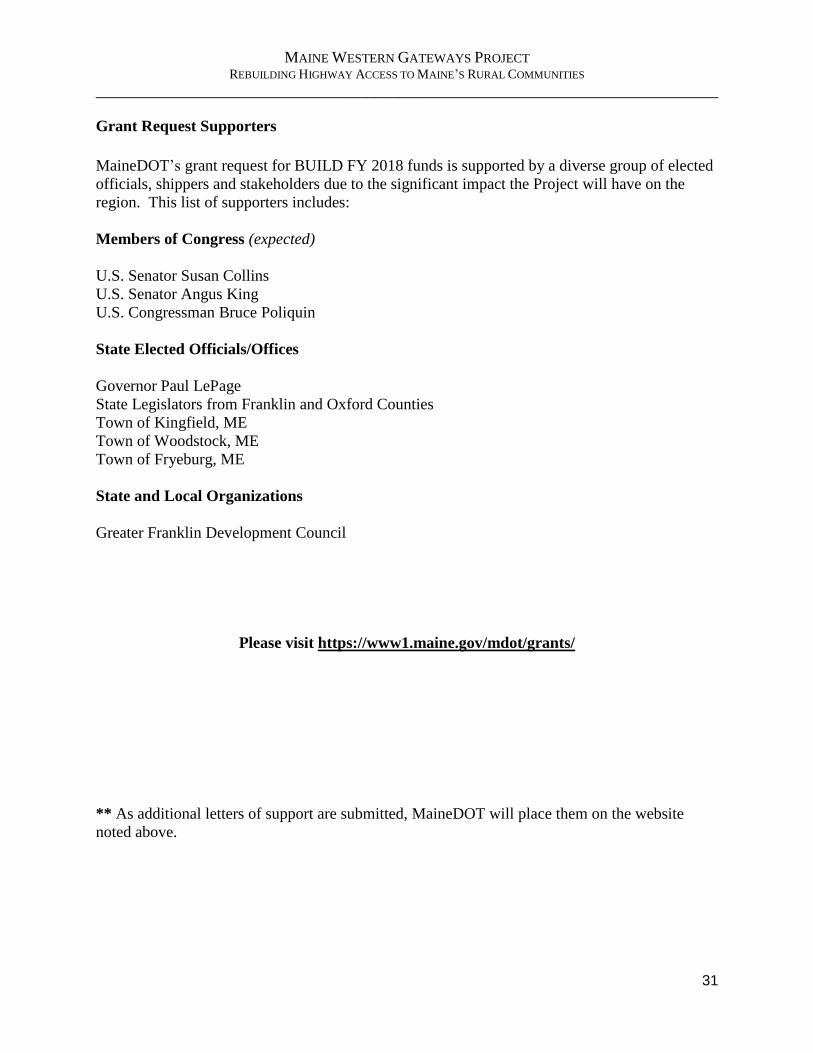
MAINE WESTERN GATEWAYS PROJECT REBUILDING HIGHWAY ACCESS TO MAINE’S RURAL COMMUNITIES
______________________________________________________________________________
31
Grant Request Supporters
MaineDOT’s grant request for BUILD FY 2018 funds is supported by a diverse group of elected
officials, shippers and stakeholders due to the significant impact the Project will have on the
region. This list of supporters includes:
Members of Congress (expected)
U.S. Senator Susan Collins
U.S. Senator Angus King
U.S. Congressman Bruce Poliquin
State Elected Officials/Offices
Governor Paul LePage
State Legislators from Franklin and Oxford Counties
Town of Kingfield, ME
Town of Woodstock, ME
Town of Fryeburg, ME
State and Local Organizations
Greater Franklin Development Council
Please visit https://www1.maine.gov/mdot/grants/
** As additional letters of support are submitted, MaineDOT will place them on the website
noted above.

MAINE WESTERN GATEWAYS PROJECT REBUILDING HIGHWAY ACCESS TO MAINE’S RURAL COMMUNITIES
______________________________________________________________________________
32
APPENDIX
Benefit-Cost Analysis Worksheet A
Maps with Project Locations B
Gantt Chart C
Letters of Support D
Match Commitment Letter E
Federal Wage Certification Letter F