u.s. department of the interior, national park service ... · u.s. department of the interior,...
TRANSCRIPT

Guidelines for Evaluating and Documenting Rural Historic Landscapes, National Register of Historic Places Bulletin (Nrb 30)
U.S. Department of the Interior, National Park Service National Register, History and Education
by Linda Flint McClelland, National Park Service
andJ. Timothy Keller, ASLA
Genevieve P. KellerRobert Z. Melnick, ASLA
Land and Community Associates
1989; Revised 1999
http://www.cr.nps.gov/nr/publications/bulletins/nrb30/ (1 of 3)12/1/2006 3:46:25 PM

Guidelines for Evaluating and Documenting Rural Historic Landscapes, National Register of Historic Places Bulletin (Nrb 30)
Photo Caption: On the eastern slopes of the Rocky Mountains, the Nathaniel K. Boswell Ranch reflects the 100-year evolution of a typical Wyoming livestick ranch. Hay was grown on the bottomland along the Laranie River, while cattle and other livestock grazed on hillsides of sage and grass. The headquarters, consisting of a house, barns, bunkhouses, sheds, privies, fences, pens, and corrals, reflects the central operations of the ranch and is also a distinctive collection of late 19th century log construction. (Photo by Mark Junge)
Table of Contents
MISSION
INTRODUCTION
WHAT IS A RURAL HISTORIC LANDSCAPE?
TYPES OF RURAL HISTORIC LANDSCAPES
CHARACTERISTICS OF THE RURAL LANDSCAPE
SKILLS REQUIRED
IDENTIFICATION
EVALUATION
REGISTRATION
RECOMMENDED READING AND SOURCES
CREDITS AND ACKNOWLEDGEMENTS
APPENDIX: DOCUMENTATION OF LANDSCAPE CHARACTERISTICS
National Register Home | Publications Home | | Next Page
Comments or Questions
http://www.cr.nps.gov/nr/publications/bulletins/nrb30/ (2 of 3)12/1/2006 3:46:25 PM

Mission: Guidelines for Evaluating and Documenting Rural Historic Landscapes, National Register of Historic Places Bulletin (Nrb 30)
U.S. Department of the Interior, National Park Service National Register, History and Education
Mission Statement
The mission of the Department of the Interior is to protect and provide access to our Nation's natural and cultural heritage and honor our trust responsibilities to tribes.
This material is partially based upon work conducted under a cooperative agreement with the National Conference of State Historic Preservation Officers and the U.S. Department of the Interior.
National Register Home | Publications Home | Previous Page | Next Page
Comments or Questions
JPJ
http://www.cr.nps.gov/nr/publications/bulletins/nrb30/nrb30_1.htm12/1/2006 3:46:53 PM

Introduction: Guidelines for Evaluating and Documenting Rural Historic Landscapes, National Register of Historic Places Bulletin (Nrb 30)
U.S. Department of the Interior, National Park Service National Register, History and Education
INTRODUCTION
The 160-acre Kehilbeck Farmstead in Cass County, Nebraska, reflects the standard historic property formed by the United States rectangular land survey. The farm's spatial organization indicates the separation of agricultural activities and many of the improvements, functional and aesthetic, that midwestern farms underwent in the late 19th and early 20th centuries. Landscape features include a formal alleé and curved entry drive, windbreaks of Eastern Red Cedar and Austrian Pine, a farmyard with orchards and vegetable gardens, pastures with livestock enclosures, and outlying fields of corn, hay or oats. (Nebraska State Historical Society)
This bulletin offers guidance to Federal agencies, State Historic Preservation Offices, Certified Local Governments, preservation professionals, and interested individuals in the successful preparation of nominations to the National Register of Historic Places and requests for determinations of eligibility for historic sites or districts known as rural historic landscapes. In recent years, there has been a growing interest among preservationists in recognizing and protecting the cultural values that centuries of land use and occupation have embodied in rural America. Understanding the forces that have shaped rural properties, interpreting their historical importance, and planning for their protection are current challenges in historic preservation. This bulletin responds to the many questions that have risen out of efforts to apply the National Register criteria to rural properties possessing significant land areas.
This bulletin defines a rural historic landscape, describes its characteristics, and suggests practical methods for survey and research. It also closely examines how the National Register criteria can be applied, significance and integrity evaluated, and boundaries drawn for rural properties having
http://www.cr.nps.gov/nr/publications/bulletins/nrb30/nrb30_2.htm (1 of 2)12/1/2006 3:47:10 PM

Introduction: Guidelines for Evaluating and Documenting Rural Historic Landscapes, National Register of Historic Places Bulletin (Nrb 30)
significant acreage. Finally, the bulletin discusses the information needed to register these properties in the National Register.
The bulletin is organized under three general headings: identification, evaluation, and registration. It puts forth a practical approach, not a complete or rigid methodology, that can be applied within a preservation planning framework to both the general development of historic contexts and the evaluation of properties within rural areas. It should be used with National Register Bulletin: Guidelines for Local Surveys: A Basis for Preservation Planning and National Register Bulletin: How to Complete the National Register Registration Form, which provide general guidance on developing historic context, conducting surveys, and completing National Register forms.
National Register Home | Publications Home | Previous Page | Next Page
Comments or Questions
JPJ
http://www.cr.nps.gov/nr/publications/bulletins/nrb30/nrb30_2.htm (2 of 2)12/1/2006 3:47:10 PM

What Is? Guidelines for Evaluating and Documenting Rural Historic Landscapes, National Register of Historic Places Bulletin (Nrb 30)
U.S. Department of the Interior, National Park Service National Register, History and Education
WHAT IS A RURAL HISTORIC LANDSCAPE?
The cultivation of filberts, seen at Dorris Ranch in Lane County, Oregon, is just one of the many activities for which a rural landscape may be significant in agriculture. From a single orchard of 50 trees planted in 1903, George B. Dorris started a ranch that became known nationally for its production of filberts and hardy planting stock. Today, orchards cover 75 acres, contain 9250 trees, and produce an average of 56 tons of nuts annually. (Willamalane Park and Recreation District)
The rural historic landscape is one of the categories of property qualifying for listing in the National Register as a historic site or district. For the purposes of the National Register, a rural historic landscape is defined as a geographical area that historically has been used by people, or shaped or modified by human activity, occupancy, or intervention, and that possesses a significant concentration, linkage, or continuity of areas of land use, vegetation, buildings and structures, roads and waterways, and natural features.
Rural landscapes commonly reflect the day-to-day occupational activities of people engaged in traditional work such as mining, fishing, and various types of agriculture. Often, they have developed and evolved in response to both the forces of nature and the pragmatic need to make a living. Landscapes small in size and having no buildings or structures, such as an ex- perimental orchard, are classified as sites. Most, however, being extensive in acreage and containing a number of buildings, sites, and structures--such as a ranch or farming community--are classified as historic districts.
http://www.cr.nps.gov/nr/publications/bulletins/nrb30/nrb30_3.htm (1 of 4)12/1/2006 3:47:47 PM

What Is? Guidelines for Evaluating and Documenting Rural Historic Landscapes, National Register of Historic Places Bulletin (Nrb 30)
Large acreage and a proportionately small number of buildings and structures differentiate rural historic landscapes from other kinds of historic properties.
Distinct from designed landscapes (see National Register Bulletin: How to Evaluate and Nominate Designed Historic Landscapes), rural landscapes usually are not the work of a professional designer and have not been developed according to academic or professional design standards, theories, or philosophies of landscape architecture. The properties discussed in this bulletin possess tangible features, called landscape characteristics, that have resulted from historic human use. In this way, they also differ from natural areas that embody important cultural values but have experienced little modification, such as sites having religious meaning for Native American groups (see National Register Bulletin: Guidelines for Evaluating and Documenting Traditional Cultural Properties).
A rural area may contain one or more rural historic landscapes. It may also include other kinds of historically significant properties, such as a railroad depot or a granary with little acreage. The National Register lists only those properties satisfying the National Register criteria for historical significance and integrity. An understanding of historic contexts is essential for identifying the significant properties of a rural area and determining the eligibility of any particular property.
Primary is significance, ascribed by specific criteria and weighed within the framework of a community, region, or State's historic contexts. Historic contexts provide background information about the patterns of history and development that shaped a particular geographical area. This information links a rural property with important historic trends or themes, such as dairy farming or cattle grazing, indicating whether the property is unique or representative of its time and place. Contextual information also allows the grouping of properties having similar patterns of historic development, making it possible to weigh their relative importance.
Historic integrity, a measure of a property's evolution and current condition, is also necessary. A comparison of the changes experienced by a group of properties related by common historic contexts helps define the historic characteristics and qualities of integrity that qualify a rural property for listing. Recent changes that have erased historic characteristics, and do not have exceptional importance, make a property ineligible, even if scenic qualities are still present.
Spatial organization, concentration of historic characteristics, and evidence of the historic period of development distinguish a rural historic landscape from its immediate surroundings. In most instances, the natural environment has influenced the character and composition of a rural area, as well as the ways that people have used the land. In turn, people, through traditions, tastes, technologies, and activities, have consciously and unconsciously modified the natural environment. Politics, social customs, ownership, economics, and natural resources have determined the organization of rural communities and the historic properties they contain.
http://www.cr.nps.gov/nr/publications/bulletins/nrb30/nrb30_3.htm (2 of 4)12/1/2006 3:47:47 PM

What Is? Guidelines for Evaluating and Documenting Rural Historic Landscapes, National Register of Historic Places Bulletin (Nrb 30)
SYNOPSIS
A rural historic landscape is:
a geographical area that historically has been used by people, or shaped or modified by human activity, occupancy, or intervention, and that possesses a significant concentration, linkage, or continuity of areas of land use, vegetation, buildings and structures, roads and waterways, and natural features.
The evidence of human use or activity is examined through eleven landscape characteristics:
* land uses and activities * patterns of spatial organization * response to the natural environment * cultural traditions * circulation networks * boundary demarcations * vegetation related to land use * buildings, structures, and objects * clusters * archeological sites * small-scale elements.
Rural historic landscapes are listed in the National Register as:
* sites or * historic districts
following:
* identification of historic landscape characteristics, * evaluation according to the National Register criteria, and * documentation on a registration form.
To identify a rural historic landscape:
* develop historic context, * conduct historic research, and * survey the landscape.
To evaluate National Register eligibility:
* define significance, * assess historic integrity, and
http://www.cr.nps.gov/nr/publications/bulletins/nrb30/nrb30_3.htm (3 of 4)12/1/2006 3:47:47 PM

What Is? Guidelines for Evaluating and Documenting Rural Historic Landscapes, National Register of Historic Places Bulletin (Nrb 30)
* select boundaries.
To register a rural historic landscape:
* complete the National Register Registration Form (NPS 10-900), and * follow the procedures in 36 CFR Part 60.
National Register Home | Publications Home | Previous Page | Next Page
Comments or Questions
JPJ
http://www.cr.nps.gov/nr/publications/bulletins/nrb30/nrb30_3.htm (4 of 4)12/1/2006 3:47:47 PM

Types: Guidelines for Evaluating and Documenting Rural Historic Landscapes, National Register of Historic Places Bulletin (Nrb 30)
U.S. Department of the Interior, National Park Service National Register, History and Education
TYPES OF RURAL HISTORIC LANDSCAPES
Drainage ditches and canals divide the agricultural fields and flat plains of Lake Landing in Hyde County, North Carolina. Implemented in the 19th century, this system made possible water transportation and the farming of swampy lowlands. Coastal plain cottages represent the common housing stock of the region. (J. Timothy Keller)
Rural historic landscapes usually fall within one of the following types based upon historic occupation or land use:
* agriculture (including various types of cropping and grazing) * industry (including mining, lumbering, fish-culturing, and milling) * maritime activities such as fishing, * shellfishing, and shipbuilding recreation (including hunting or fishing camps) * transportation systems * migration trails * conservation (including natural reserves) * sites adapted for ceremonial, religious, or other cultural activities, such as camp meeting grounds.
Although diverse, these types all contain substantial areas of vegetation; open space; or natural features that embody, through past use or physical character, significant historical values. Buildings, industrial structures, objects, designed landscapes, and archeological sites may also be present. Many will be integrally related to historic activities and contribute to the significance of a large historic district. Some may also qualify individually for listing in the National Register.
Rural historic landscapes, especially those composed of a variety of land uses, may incorporate more than one of the types listed above. While this bulletin introduces a methodology that can be used for evaluating all of the above types, it focuses primarily on agricultural properties.
http://www.cr.nps.gov/nr/publications/bulletins/nrb30/nrb30_4.htm (1 of 2)12/1/2006 3:48:11 PM

Characteristics: Guidelines for Evaluating and Documenting Rural Historic Landscapes, National Register of Historic Places Bulletin (Nrb 30)
U.S. Department of the Interior, National Park Service National Register, History and Education
CHARACTERISTICS OF THE RURAL LANDSCAPE
Rich deposits of lime and limeston ensured the prosperity and agricultural productivity of Oley Township, Pennsylvania. In response to the natural environment, settlers farmed fertile soil, operated limekilns, and constructed homes, barns, outbuildings, and walls of native limestone. (Oley Resource Conservation Project)
A classification system of eleven characteristics has been developed for reading a rural landscape and for understanding the natural and cultural forces that have shaped it. Landscape characteristics are the tangible evidence of the activities and habits of the people who occupied, developed, used, and shaped the land to serve human needs; they may reflect the beliefs, attitudes, traditions, and values of these people.
The first four characteristics are processes that have been instrumental in shaping the land, such as the response of farmers to fertile soils. The remaining seven are physical components that are evident on the land, such as barns or orchards. Many, but not all, rural properties contain all eleven characteristics. When historic processes are linked to existing components, the rural landscape can be viewed as a unified whole. The section "Documentation of Landscape Characteristics" shows the relationship of the eleven characteristics and the features represented by them.
This classification system is a tool for gathering and organizing information. First of all, it is used to develop historic contexts for rural areas. The processes define specific themes, such as dairy farming or Belgian settlement, that have influenced historic development. The physical components define historic
http://www.cr.nps.gov/nr/publications/bulletins/nrb30/nrb30_5.htm (1 of 7)12/1/2006 3:48:33 PM

Characteristics: Guidelines for Evaluating and Documenting Rural Historic Landscapes, National Register of Historic Places Bulletin (Nrb 30)
features of the landscape that may be used to describe significant property types and to identify properties eligible for listing in the National Register.
Second, the system is used to identify and evaluate the significant properties of a rural area or to determine the eligibility of a particular rural landscape. Through field survey and historic research, characteristics are associated with specific features, such as field patterns or roadways, and provide an understanding of an area or property's historic land uses and physical evolution.
Third, as information about existing characteristics is related to the historic contexts for a geographical area, assessments of significance, integrity, and boundaries can be made for specific properties. Information is evaluated to determine whether, within a rural area or region, a large historic district or separate properties should be considered for listing in the National Register. A comparison of past and present characteristics within a single property helps determine whether the property retains historic integrity and what the National Register boundaries should be.
Finally, the classification system provides a format for documenting rural properties on National Register forms. It can be used to organize the description and statement of significance for a specific rural property on the registration form. It is also useful for organizing information about rural historic contexts and property types on the multiple property documentation form.
PROCESSES
1. Land Uses and Activities: Land uses are the major human forces that shape and organize rural communities. Human activities, such as farming, mining, ranching, recreation, social events, commerce, or industry, have left an imprint on the landscape. An examination of changing and continuing land uses may lead to a general understanding of how people have interacted with their environment and provide clues about the kinds of physical features and historic properties that should be present.
Topographic variations, availability of transportation, the abundance or scarcity of natural resources (especially water), cultural traditions, and economic factors influenced the ways people use the land. Changing land uses may have resulted from improved technology, exhausted soils or mineral deposits, climatic changes, and new economic conditions, as well as previous successes or failures. Activities visible today may reflect traditional practices
http://www.cr.nps.gov/nr/publications/bulletins/nrb30/nrb30_5.htm (2 of 7)12/1/2006 3:48:33 PM

Characteristics: Guidelines for Evaluating and Documenting Rural Historic Landscapes, National Register of Historic Places Bulletin (Nrb 30)
Taro, the staple of the islanders' daily diet is the primary crop of Hanalei, Hawaii. Traditionally grown, it is dependent on a warm humid climate and wetland agriculture made possible by abundant rainfall and irrigation. (Robert Z. Melnick)
or be innovative, yet compatible, adaptations of historic ones.
Taro fields separated by earthen dikes, forested mountains, rivers and irrigation ditches, and a system of roads define the pattern of spatial organization and characterize the area's wetland agriculture in Hanalei, Hawaii. (Robert Z. Melnick)
2. Patterns of Spatial Organization: The organization of land on a large scale depends on the relationship among major physical components, predominant landforms, and natural features. Politics, economics, and technology, as well as the natural environment, have influenced the organization of communities by determining settlement patterns, proximity to markets, and the availability of transportation.
Organization is reflected in road systems, field patterns, distance between farmsteads, proximity to water sources, and orientation of structures to sun and wind. For example, spatial patterns can be seen in the grid of square mile townships and 160-acre farmsteads
http://www.cr.nps.gov/nr/publications/bulletins/nrb30/nrb30_5.htm (3 of 7)12/1/2006 3:48:33 PM

Characteristics: Guidelines for Evaluating and Documenting Rural Historic Landscapes, National Register of Historic Places Bulletin (Nrb 30)
in the Midwest established by the land ordinances of 1785 and 1787; the distribution of towns every seven miles along a railroad corridor; and the division of land in Louisiana, by the French long-lot system, to ensure that every parcel has river frontage.
Large-scale patterns characterizing the settlement and early history of a rural area may remain constant, while individual features, such as buildings and vegetation, change over time. Changes in technology, for example, may have altered plowing practices, although the location of plowed fields, and, therefore, the overall historic pattern may remain the same.
3. Response to the Natural Environment: Major natural features, such as mountains, prairies, rivers, lakes, forests, and grasslands, influenced both the location and organization of rural communities. Climate, similarly, influenced the siting of buildings, construction materials, and the location of clusters of buildings and structures. Traditions in land use, construction methods, and social customs commonly evolved as people responded to the physiography and ecological systems of the area where they settled.
Early settlements frequently depended upon available natural resources, such as water for transportation, irrigation, or mechanical power. Mineral or soil deposits, likewise, determined the suitability of a region for particular activities. Available materials, such as stone or wood, commonly influenced the construction of houses, barns, fences, bridges, roads, and community buildings.
4. Cultural Traditions: Cultural traditions affect the ways that land is used, occupied, and shaped. Religious beliefs, social customs, ethnic identity, and trades and skills may be evident today in both physical features and uses of the land. Ethnic customs, predating the origins of a community, were often transmitted by early settlers and perpetuated by successive generations. Others originated during a community's early development and evolution. Cultural groups have interacted with the natural environment, manipulating and perhaps altering it, and sometimes modifying their traditions in response to it.
Cultural traditions determined the structure of communities by influencing the diversity of buildings, location of roads and village centers, and ways the land was worked. Social customs dictated the crops planted or livestock raised. Traditional building forms, methods of construction, stylistic finishes, and functional solutions evolved in the work of local artisans. For example, rustic saunas appeared among the outbuildings of Finnish farmsteads in northwestern Michigan, while community churches occupied isolated crossroads in the High Plains. Taro, grown as a staple in the Hawaiian daily diet, also assumed an important role in the traditional luau. At the Amana Colonies in Iowa, large expanses of farmland and forest--based upon communal ownership, a village settlement pattern, and religious beliefs--varied from the rectangular grid typical of Midwestern family farms.
COMPONENTS
5. Circulation Networks: Circulation networks are systems for transporting people, goods, and raw materials from one point to another. They range in scale from livestock trails and footpaths, to roads, canals, major highways, and even airstrips. Some, such as farm or lumbering roads, internally served a rural community, while others, such as railroads and waterways, connected it to the surrounding region.
http://www.cr.nps.gov/nr/publications/bulletins/nrb30/nrb30_5.htm (4 of 7)12/1/2006 3:48:33 PM

Characteristics: Guidelines for Evaluating and Documenting Rural Historic Landscapes, National Register of Historic Places Bulletin (Nrb 30)
6. Boundary Demarcations: Boundary demarcations delineate areas of ownership and land use, such as an entire farmstead or open range. They also separate smaller areas having special functions, such as a fenced field or enclosed corral. Fences, walls, tree lines, hedge rows, drainage or irrigation ditches, roadways, creeks, and rivers commonly marked historic boundaries.
7. Vegetation Related to Land Use: Various types of vegetation bear a direct relationship to long-established patterns of land use. Vegetation includes not only crops, trees, or shrubs planted for agricultural and ornamental purposes, but also trees that have grown up incidentally along fence lines, beside roads, or in abandoned fields. Vegetation may include indigenous, naturalized, and introduced species.
While many features change over time, vegetation is, perhaps, the most dynamic. It grows and changes with time, whether or not people care for it. Certain functional or ornamental plantings, such as wheat or peonies, may be evident only during selected seasons. Each species has a unique pattern of growth and life span, making the presence of historic specimens questionable or unlikely in many cases. Current vegetation may differ from historic vegetation, suggesting past uses of the land. For example, Eastern red cedars or aspens indicate the natural succession of abandoned farmland in the Midwest.
The corral cluster at Spade Ranch in Sheridan County, Nebraska, contains numerous structures associated with the historic functions of a cattle ranch. These include scales for weighing livestock; pens for sorting, breaking, and branding; and chutes for roping and loading. (David Murphy)
8. Buildings, Structures, and Objects: Various types of buildings, structures, and objects serve human needs related to the occupation and use of the land. Their function, materials, date, condition, construction methods, and location reflect the historic activities, customs, tastes, and skills of the people who built and used them.
Buildings--designed to shelter human activity--include residences, schools, churches, outbuildings, barns, stores, community halls, and train depots. Structures--designed for functions other than shelter--include dams, canals, systems of fencing, systems of irrigation, tunnels, mining shafts, grain
elevators, silos, bridges, earthworks, ships, and highways. Objects--relatively small but important stationary or movable constructions--include markers and monuments, small boats, machinery, and equipment.
Rural buildings and structures often exhibit patterns of vernacular design that may be common in their region or unique to their community. Residences may suggest family size and relationships, population densities, and economic fluctuations. The repeated use of methods, forms, and materials of construction may indicate successful solutions to building needs or demonstrate the unique skills, workmanship, or talent of a local artisan.
http://www.cr.nps.gov/nr/publications/bulletins/nrb30/nrb30_5.htm (5 of 7)12/1/2006 3:48:33 PM

Characteristics: Guidelines for Evaluating and Documenting Rural Historic Landscapes, National Register of Historic Places Bulletin (Nrb 30)
One of the most extensive and intact clusters of agricultural outbuildings in the Lake Landing Historic District, Hyde County, North Carolina, consists of a wash house, outhouse, buggy house, harness shed, chicken house, two barns and wood fences. (J. Timothy Keller)
9. Clusters: Groupings of buildings, fences, and other features, as seen in a farmstead, ranch, or mining complex, result from function, social tradition, climate, or other influences, cultural or natural. The arrangement of clusters may reveal information about historical and continuing activities, as well as the impact of varying technologies and the preferences of particular generations. The repetition of similar clusters throughout a landscape may indicate vernacular patterns of siting, spatial organization, and land use. Also, the location of clusters, such as the market towns that emerged at the crossroads of early highways, may reflect broad patterns of a region's cultural geography.
10. Archeological Sites: The sites of prehistoric or historic activities or occupation, may be marked by foundations, ruins, changes in vegetation, and surface remains. They may provide valuable information about the ways the land has been used, patterns of social history, or the methods and extent of activities such as shipping, milling, lumbering, or quarrying. The ruins of mills, charcoal kilns, canals, outbuildings, piers, quarries, and mines commonly indicate previous uses of the land. Changes in vegetation may indicate abandoned roadways, homesites, and fields. The spatial distribution of features, surface disturbances, subsurface remains, patterns of soil erosion and deposition, and soil composition may also yield information about the evolution and past uses of the land.
11. Small-scale elements: Small-scale elements, such as a foot bridge or road sign, add to the historic
http://www.cr.nps.gov/nr/publications/bulletins/nrb30/nrb30_5.htm (6 of 7)12/1/2006 3:48:33 PM

Characteristics: Guidelines for Evaluating and Documenting Rural Historic Landscapes, National Register of Historic Places Bulletin (Nrb 30)
setting of a rural landscape. These features may be characteristic of a region and occur repeatedly throughout an area, such as limestone fence posts in Kansas or cattle gates in the Buffalo River Valley of Arkansas. While most small-scale elements are long-lasting, some, such as bales of hay, are temporal or seasonal. Collectively, they often form larger components, such as circulation networks or boundary demarcations. Small-scale elements also include minor remnants--such as canal stones, road traces, mill stones, individual fruit trees, abandoned machinery, or fence posts--that mark the location of historic activities, but lack significance or integrity as archeological sites.
National Register Home | Publications Home | Previous Page | Next Page
Comments or Questions
JPJ
http://www.cr.nps.gov/nr/publications/bulletins/nrb30/nrb30_5.htm (7 of 7)12/1/2006 3:48:33 PM

Skills: Guidelines for Evaluating and Documenting Rural Historic Landscapes, National Register of Historic Places Bulletin (Nrb 30)
U.S. Department of the Interior, National Park Service National Register, History and Education
SKILLS REQUIRED
Fishing boats, wharves, canals, and a cluster of dwellings at Skamokawa, Washington, illustrate the important role that salmon-fishing has played along the Columbia River since the mid-19th century.
Examination of a rural area frequently requires the combined efforts of historians, landscape historians, architectural historians, architects, landscape architects, archeologists, and anthropologists. Depending on the area, the specialized knowledge of cultural geographers, plant ecologist, folklorists, and specialists in the history of agriculture, forestry, mining, transportation, and other types of land use may also be of assistance.
To prepare nominations for rural historic landscapes, persons should be able to identify various landscape characteristics during field investigations and should know the terminology used to describe the major processes, uses, and physical components visible in the landscape. They should also be familiar with the historical development of the region where they are working, know how to research appropriate sources, and understand the roles of the specialists listed above.
http://www.cr.nps.gov/nr/publications/bulletins/nrb30/nrb30_6.htm (1 of 2)12/1/2006 3:48:50 PM

Identification: Guidelines for Evaluating and Documenting Rural Historic Landscapes, National Register of Historic Places Bulletin (Nrb 30)
U.S. Department of the Interior, National Park Service National Register, History and Education
IDENTIFICATION
NATIONAL REGISTER PROCESS
Identification
● Develop historic context ● Conduct historic research ● Survey the landscape
Evaluation
● Define significance
1. Apply the National Register criteria 2. Select areas of significance 3. Define period of significance
● Assess integrity
1. Apply qualities of integrity 2. Identify changes and threats to integrity 3. Classify contributing and noncontributing resources 4. Weigh overall integrity
● Select defensible boundaries
http://www.cr.nps.gov/nr/publications/bulletins/nrb30/nrb30_7.htm (1 of 9)12/1/2006 3:49:13 PM
Identification: Guidelines for Evaluating and Documenting Rural Historic Landscapes, National Register of Historic Places Bulletin (Nrb 30)
1. Define the historic property 2. Decide what to include 3. Select appropriate edges
Registration
● Complete National Register form (s) ● Follow registration procedures in 36 CRF Part 60
An in-depth study is necessary to identify the significant historic properties of a rural area or to determine if the area as a whole is a historic district. An understanding of important aspects of a community, region, or State's historic development and physiography, in the form of historic contexts, helps identify rural areas that merit study and indicates the reasons they may be significant.
The study requires several steps: the history of the area targeted for study is related to local or State contexts, historical records are examined, and existing landscape characteristics are surveyed. The purpose of the study is to gather the information needed to make decisions about the eligibility for the National Register of the entire area or smaller properties within it. The guidance below describes historic resource studies in rural areas; it supplements the general guidelines in National Register Bulletin 24: Guidelines for Local Surveys: A Basis for Preservation Planning.
Developing Historic Context
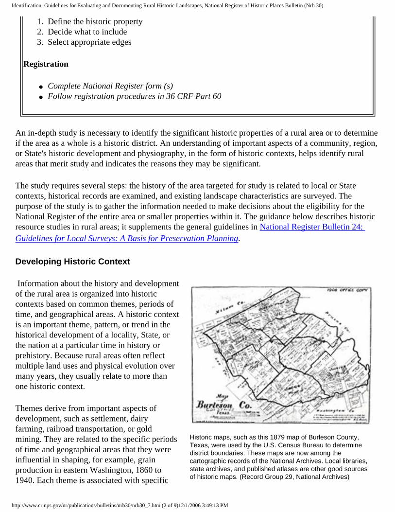
Historic maps, such as this 1879 map of Burleson County, Texas, were used by the U.S. Census Bureau to determine district boundaries. These maps are now among the cartographic records of the National Archives. Local libraries, state archives, and published atlases are other good sources of historic maps. (Record Group 29, National Archives)
Information about the history and development of the rural area is organized into historic contexts based on common themes, periods of time, and geographical areas. A historic context is an important theme, pattern, or trend in the historical development of a locality, State, or the nation at a particular time in history or prehistory. Because rural areas often reflect multiple land uses and physical evolution over many years, they usually relate to more than one historic context.
Themes derive from important aspects of development, such as settlement, dairy farming, railroad transportation, or gold mining. They are related to the specific periods of time and geographical areas that they were influential in shaping, for example, grain production in eastern Washington, 1860 to 1940. Each theme is associated with specific
http://www.cr.nps.gov/nr/publications/bulletins/nrb30/nrb30_7.htm (2 of 9)12/1/2006 3:49:13 PM
Identification: Guidelines for Evaluating and Documenting Rural Historic Landscapes, National Register of Historic Places Bulletin (Nrb 30)
types of historic properties, such as granary complexes or large wheat-growing ranches, that may be eligible for listing in the National Register.
A knowledge of historic contexts can guide the selection of a study area that is likely to possess historic landscape characteristics and contain one or more significant properties, including rural historic landscapes. For example, the knowledge that cherry production played an important role in a State's agricultural economy since the early 20th century, or that reforestation has occurred in 80 percent of a county extensively farmed in the 1840s can lead to the identification of significant cherry-producing areas or reforested farms that have evidence of early land uses and division.
A knowledge of contexts provides a historical focus for conducting a rural study. It helps in determining the appropriate sources for research, survey techniques, professionals to make up the study team, and specialists to consult. It gives team members direction on the kinds of properties they are likely to encounter in the field, the characteristics they should look for and record, and the historical documentation that will be most useful for evaluating significance. It enables them to view landscape characteristics as integral parts of overall economic or social systems rather than isolated features. For example, a drainage ditch is seen as part of an extensive system of waterways that allowed thousands of acres of tidewater to be settled and farmed.
A written statement of historic contexts should be developed at the beginning of the study. The statement incorporates or references information about previously identified contexts and documented historic properties. It also documents contexts identified during the initial consideration of the study area. It includes research questions to guide the analysis of landscape characteristics and describes the characteristics that an eligible rural property must possess. The statement can be refined, augmented, and revised as information is gathered during identification, as evaluation proceeds, and when National Register forms are completed.
State Historic Preservation Offices, Federal Preservation Officers, and some local governments, are defining historic contexts as part of their historic preservation planning process. These may be a source of comparative and thematic information about patterns of community or regional development, specialized activities, and properties important in the history of a particular State or locality.
Sources on both cultural and natural history should be consulted. Facts about the events, persons, groups, and physical development that shaped an area's cultural identity may be found in State or local histories, archeological studies, or specialized studies on topics such as transportation, ethnic heritage, vernacular architecture, irrigation, wheat farming, mining, or hardwood lumbering. Historic maps, plats, and land records provide valuable information about historic boundaries and ownership, circulation networks, clusters, and land uses. Studies on physical geography provide information about topography, soils, climate, natural vegetation, and water resources that determined land uses, circulation networks, and spatial organization. Ecological studies may address hydrology, climate, patterns of vegetation, and biotic communities that have influenced land uses, vegetation, and responses to the environment.
The eleven landscape characteristics relate to historic contexts in several ways. The four processes--land uses and activities, patterns of spatial organization, response to the natural environment, and cultural traditions--directly reflect themes on which contexts are based. Knowledge of a region's settlement
http://www.cr.nps.gov/nr/publications/bulletins/nrb30/nrb30_7.htm (3 of 9)12/1/2006 3:49:13 PM

Identification: Guidelines for Evaluating and Documenting Rural Historic Landscapes, National Register of Historic Places Bulletin (Nrb 30)
patterns, natural topography, cultural influences, and historic land uses, provides an understanding of how a region was organized and developed historically. For example, waterways in the Colonial period influenced settlements around natural harbors and at the fords and falls of rivers, and Hispanic traditions of land division in New Mexico created a recurring pattern of long narrow fields.
Landscape processes explain how communities were structured and divided into smaller units based on ownership, land use, geography, politics, social custom, and economic needs. This information is a logical basis for defining property types that existed in a particular geographical area during a period of history, for example, a square mile township, a 10,000-acre ranch, or a 160-acre farm. Rural property types can be described by the landscape characteristics and the features representing them.
Property types meeting the definition of rural historic landscape--such as a village cluster with outlying farms--become manageable units for survey, evaluation, and National Register listing. Landscape characteristics not only define the types, but also explain their interrelationship and evolution from a historical perspective. As survey and research proceed, the characteristics become the hallmarks of historic properties that should be considered for National Register listing.
Conducting Historic Research
Useful sources for studying the history of rural areas include: historic maps and plats, historic photographs, aerial photographs, census records, local and county histories, federal land-grant records, homestead papers, deeds, wills, diaries, commercial records, newspapers, farm accounts and receipts, soil surveys, vegetation surveys, oral histories, local stories and folklore, and family records.
Selection of sources, for both general information and references to specific properties, should be based upon the statement of historic context and the character of the rural area under study.
Historic maps indicate the location of historic roads, settlements, mills, ports, quarries, and meeting houses. Land records, plats, deeds, and wills indicate the historic ownership of land, patterns of land division, and historic boundaries of properties. Historic photographs indicate changes in land use practices, land division, vegetation, and clusters. Historic periodicals may help date developments in technology--such as fencing materials, dry-land
http://www.cr.nps.gov/nr/publications/bulletins/nrb30/nrb30_7.htm (4 of 9)12/1/2006 3:49:13 PM

Identification: Guidelines for Evaluating and Documenting Rural Historic Landscapes, National Register of Historic Places Bulletin (Nrb 30)
An 1847 map of Berkely County, Virginia (now West Virginia), indicated land ownership, roads and waterways, natural features, and county boundaries. It also provided statistics on acreage, population, crop production, livestock, schools, and manufacturing capital. (Record Group 77, National Archives)
farming, or irrigation techniques--that have affected the division or character of land. In addition to original applications, homestead records at the Washington National Records Center (Suitland, Maryland) include the proofs filed after settlement to fulfill the terms of ownership; these describe early land uses, improvements, and buildings. Changes in spatial organization can be observed by comparing aerial photographs of various dates. Population schedules of the U.S. Census provide demographic information, such as the size of households, occupations, and ethnic associations. Also, census records for agriculture and industry provide data and statistics on the historic land uses, ownership, and productivity of an area. Agricultural census records may also indicate the kinds and numbers of livestock on farms, and whether they were fenced or at free range.
Agricultural practices generally vary from state to state, and region to region. Agricultural periodicals, such as the Michigan Farmer or Connecticut Valley Farmer and Mechanics, were published state by state or regionally beginning in the early 19th century. State colleges of agriculture, established under the Morrill Act of 1862, and experiment stations first established in 1887 became valuable sources of information for farmers on topics of science, agriculture, and even construction methods for farm buildings. Similarly, mining periodicals and the publications of mining schools, in many states, provide information about scientific and technological advances that affected mining activities.
In 1935, the Soil Conservation and Agricultural Stabilization and Conservation Services began recording rural areas through aerial photography. A 1937 photograph of South Lima Township, Washtenaw County, Michigan, shows a typical midwestern pattern of farmyard clusters, roads, orchards adn fields, and wetlands. (Record Group 145, National Archives)
Beginning in the 1930s, the U.S. Soil Conservation Service assumed an active role in shaping American farms by recommending the planting of wind breaks, revitalization of soils, contour plowing, and other techniques. Reports, pamphlets, and bulletins of federal agricultural programs may be found in university libraries and archives and the National Agricultural Library of the U.S. Department of Agriculture (Beltsville, Maryland). Aerial photographs and soil maps are available from the U.S. Department of Agriculture, National Archives, EROS Data Center of the U.S. Geological Survey, and private air photo services (see Sources of Aerial Photographs). Records of other federal agencies in the National Archives, including those of the Corps of Engineers, Bureau of Mines, Bureau of Fisheries, Coast Guard, and Forest Service, also provide information on rural land uses and activities.
Oral history is often essential. Local farmers, foresters, mining engineers, and extension agents are often valuable sources of information about the agriculture, silviculture, or mining of a particular region.
http://www.cr.nps.gov/nr/publications/bulletins/nrb30/nrb30_7.htm (5 of 9)12/1/2006 3:49:13 PM

Identification: Guidelines for Evaluating and Documenting Rural Historic Landscapes, National Register of Historic Places Bulletin (Nrb 30)
Onsite interviews with local farmers may provide insight into how a farm has been managed and what changes have occurred in the past 20 to 50 years. Other long term residents, including merchants, teachers, librarians, and town officials, may recollect events or activities related to changing community patterns. Information about current vegetation and agricultural practices is available from the agricultural extension service, State experimental stations, and plant ecologists and other scientists in universities and State government.
Surveying the Landscape
Aerial photography is a valuable tool for surveying large rural areas. A recent aerial view of Hanalei, Hawaii, shows the organization of two fields, placement of irrigation ditches, system of roads, watereways and mountains, general areas of vegetation, and location of clusters. (Robert Z. Melnick)
An onsite survey is essential in gathering information about a rural area, its characteristics, and condition. The section "Documentation of Landscape Characteristics" provides a convenient checklist of the landscape characteristics that can be used in the field. The boundaries of the survey area should be based on a knowledge of historic property types, as well as current planning needs. Field investigations should be directed at identifying existing landscape characteristics and determining the extent to which historic properties and characteristics remain intact.
The amount of documentation to be collected for each characteristic depends on its relative size, scale, and importance. The statement of contexts should be used as a guide for determining which characteristics are most important given the area's primary activities, associations, and period of development. If, for example, canals played a vital role in the region early 19th century development, then locks, towpaths, canal sections, natural waterways, and associated buildings should be given particular attention. Landscape characteristics meeting the National Register definitions of building, site, structure, and object, furthermore, require classification as contributing or noncontributing and must be located on a sketch map that will accompany the National Register form.
To view a rural area from various perspectives and observe landscape characteristics, the survey team should:
● travel all roadways; ● gain access to as much acreage as possible, on foot or by car, horse, bicycle, boat, or other means
appropriate to study area; ● cover fields, orchards, forests, mines, waterways, pastures, and open range; and ● examine abandoned roadways, land use areas, and homesites, as well as those still in use.
Surveyors should be prepared to take photographs and make detailed notes and sketch maps in the field. They should be acquainted with the general history of the area, including major land uses, important
http://www.cr.nps.gov/nr/publications/bulletins/nrb30/nrb30_7.htm (6 of 9)12/1/2006 3:49:13 PM

Identification: Guidelines for Evaluating and Documenting Rural Historic Landscapes, National Register of Historic Places Bulletin (Nrb 30)
persons and events, historic property types, and the landscape characteristics that are likely to exist. They should be equipped with maps and photographs from various time periods, as well as current topographic and base maps, for reference during field investigations. On site, surveyors should:
● describe and mark on a sketch map major natural features, archeological sites, buildings, bridges, outbuildings, roadways, waterways, orchards, fields, pastures, quarries, mining shafts, and boundary demarcations;
● identify vegetation that is predominant or related to land uses; ● date features as accurately as possible (they can be verified by historical research before or after
field investigation); ● record the condition of characteristics, noting the evidence of historic field patterns, roadways, or
boundary markers; deteriorated and altered buildings and structures; ground disturbances; new land uses and construction; age and condition of vegetation; abandoned fields or roads; reforested areas; and relocated farm structures;
● note visible changes in the landscape, by comparing historic and contemporary views provided by maps, illustrations, and photographs. Indicate changes to the historic boundaries of properties due to subdivision, consolidation, growth, or abandonment;
● relate characteristics to the statement of context and historical data, by associating existing features with specific historic activities, land uses, persons, customs, and periods of time; and
● note any characteristics or processes requiring further research.
Field observations should be recorded in a standard format that can be readily used for evaluation, registration, and planning. Landscape characteristics as well as categories of information for buildings, engineering structures, districts, and archeological sites should be included. To facilitate recording landscape characteristics, the survey area should be divided into geographical units, perhaps based on the boundaries of properties under single ownership, or on quarter or half sections of United States Geological Survey (USGS) topographical maps.
Aerial surveys are useful for examining large tracts of land. Aerial views can help determine the spatial relationships among natural features, areas of land use, vegetation, waterways, roadways, and buildings and structures. When photographed at appropriate times of year, aerial views may reveal details such as stone walls or ruins that may otherwise be obscured by foliage or dense vegetation. Aerial surveys are most helpful in identifying field patterns and land division, but they are of little help in describing type condition of individual structures and buildings. Aerial photographs taken with infrared film distinguish plant materials of differing types and age, and often detect abandoned roads, buried walls, and refuse sites not visible from the ground.
Computerized Geographic Information Systems (GIS) are useful in analyzing data about rural land uses, viewsheds, clusters, and vegetation. Aerial photographs, historic maps, and current maps can be compared to determine the nature and extent of land use changes through time. GIS can create a standard scale for maps and photographs having different scales. Topographic information can be plotted with rural landscape characteristics to determine spatial organization and visual relationships by using typical operations such as map overlays, distance calculations, and interpolation. These operations can also be used to define the boundaries of National Register properties and to assess the visual impact of land use changes.
http://www.cr.nps.gov/nr/publications/bulletins/nrb30/nrb30_7.htm (7 of 9)12/1/2006 3:49:13 PM

Identification: Guidelines for Evaluating and Documenting Rural Historic Landscapes, National Register of Historic Places Bulletin (Nrb 30)
Suggestions for Completing a Rural Survey
Form used to survey the 17,000-acre Ebey's Landing National Historical Reserve in Washington recorded landscape characteristics, percentage of land uses, types of land use activities, natural topography, types of vegetation, roadways, fences, and buildings and structures. Each form covered a half-section (320 acres) of the USGS topographic grid and was supplemented by a panoramic photograph, representative photographic views, a site map, and a sectional diagram. (Pacific Northwest Regional Office, National Park Service)
1. Be comprehensive both in documentary research and site observations. Important information may be found in state and county offices, but also in local historical museums, in family collections, or through personal recollections. The physical evidence present in the landscape itself is an important source of information.
2. Use the statement of historic contexts as a guide for identifying historic properties and judging what features require the greatest attention and contribute most to historic significance. Do not hesitate to change, refine, and add to the statement as the survey proceeds. Early ideas help guide and shape further investigations.
3. Be well-equipped as you enter the field with both a knowledge of the history of the area and personal tools such as maps, aerial photos, sketch pads, markers, note pads, cameras, compasses, and binoculars. Being ready physically may be just as important as being well-prepared intellectually. Necessities such as gasoline, water, or food are not always readily available in rural areas. Field work may require special outfitting and provisions, such as hiking boots, rain gear, or insect repellent.
4. Be sensitive to ongoing rural activities and the rights of property owners. Receive permission before entering private land. Inquire about unsafe conditions or areas that are off-limits, such as newly planted fields, animal pens, uncovered wells, open mining shafts, sink holes, traps, poison ivy, or potentially dangerous animals--domestic or wild. Close gates behind you, and take care not to interrupt working operations.
5. Listen to the people who know the landscape. Talk with people, try to understand the history of the place from the viewpoint of the people who live and work there. Have specialists in aspects of
http://www.cr.nps.gov/nr/publications/bulletins/nrb30/nrb30_7.htm (8 of 9)12/1/2006 3:49:13 PM

Identification: Guidelines for Evaluating and Documenting Rural Historic Landscapes, National Register of Historic Places Bulletin (Nrb 30)
agriculture, mining, or local history and ecology accompany you in the field; they can provide important insights.
6. Keep careful records of photographs, maps, notes, ideas, and thoughts. Record the subject and vantage point of each photograph, and key the information, if possible, to a map or aerial photograph while you are in the field since this information may be difficult to recollect back in the office. Also record the film roll number, frame number, date, and photographer.
7. Remember, always, landscapes change. Historic photographs are good indicators of the ways things were and can be used to compare changes over time. Do not expect to find any property in its historic condition. Look for the landscape of the past as you would expect it to appear today. Trees may be larger, ground cover may be different, buildings may have been moved, fences may be lost or in relic condition, and farming techniques may have changed.
8. Do not rely upon any single source. Check and countercheck any information. Eyewitness accounts are not always accurate and historical photographs can sometimes be misleading. Judge the value of each historical photograph; it may record a moment in time, but not necessarily an important one.
National Register Home | Publications Home | Previous Page | Next Page
Comments or Questions
JPJ
http://www.cr.nps.gov/nr/publications/bulletins/nrb30/nrb30_7.htm (9 of 9)12/1/2006 3:49:13 PM

Evaluation: Guidelines for Evaluating and Documenting Rural Historic Landscapes, National Register of Historic Places Bulletin (Nrb 30)
U.S. Department of the Interior, National Park Service National Register, History and Education
EVALUATION
Evaluation entails three major activities: defining significance, assessing historic integrity, and selecting boundaries. Information gathered through historic research and field survey is related to the study area's historic contexts to determine the extent to which identified properties possess the characteristics of important rural property types. Significance, integrity, and boundaries depend upon the presence of tangible landscape features and the evidence of the processes, cultural and natural, that have shaped the landscape.
Historical facts and survey data should verify the presence of significant historic landscape characteristics and the condition of the properties that made up a community or region historically. For example, the historic patterns of an agricultural community subject to increasing suburbanization may be evident in eight farms having at least 75 percent of their historic acreage, a substantial number of historic buildings, and compatible agricultural use.
Patterns of change, within a regional or local context, may affect significance. For example, in a six-county region of a midwestern State, typical farmsteads contain similarly arranged clusters of corncribs, sugar houses, wellhouses, and poultry pens; fruit orchards of a standard size; maple-lined roadways; and fenced pastures. As changing agricultural methods and new land uses destroy more and more of these characteristics, isolated communities and individual farmsteads retaining the historic configuration may become eligible for National Register listing.
Properties relating to the same historic contexts may be compared to identify those eligible for listing in the National Register and to determine the relative level--local, State, or national--at which the property is significant. For example, several communities in Nebraska may have local significance for their association with Russian settlement; when they are compared, only those with a high degree of integrity--exhibited in intact field patterns, boundary demarcations, roadways, clusters of vernacular structures and buildings, and continuing traditional activities--have statewide importance.
http://www.cr.nps.gov/nr/publications/bulletins/nrb30/nrb30_8.htm (1 of 19)12/1/2006 3:49:40 PM

Evaluation: Guidelines for Evaluating and Documenting Rural Historic Landscapes, National Register of Historic Places Bulletin (Nrb 30)
Defining Significance
Integrity of feeling is a composite of several factors -- association, location, design, materials, and settings. Reflecting many years of local use, a country road in Goose Creek Historic District in Loudoun County, Virginia, retains its historic location, narrow width, unpaved surface, incidental vegetation, pastoral setting, and rural feeling. (Virginia Department of Historic Resources)
An understanding of significance is paramount. It is necessary, first, to determine whether a rural property meets the National Register criteria, and, second, to guide decisions about integrity and boundaries. Historical facts are examined to define those periods of time and aspects of development in which a specific property contributed to the broad themes, or historic contexts, important to its community, State, or the nation.
1. Apply the National Register Criteria
A property must possess significance in at least one of the four aspects of cultural heritage specified by the National Register criteria. Because of their complex evolution and the layering of subsequent land uses without destroying previous ones, many rural landscapes have significance under several criteria.
The criteria can be applied to the study area as a whole and to smaller properties within it. Judgments of significance are made by relating facts about the history and existing landscape characteristics of the study area to the themes and property types recognized as important by the area's historic contexts.
CRITERION A
Criterion A applies to properties associated with events that have made significant contributions to the broad patterns of history. Some events may have been brief, such as a battle or treaty signing. Others may be activities that spanned long periods of time and underwent substantial change, such as dairy farming or silver mining.
Criterion A recognizes the significant contributions that rural properties have made through diverse events and activities, including exploration, settlement, ethnic traditions, farming, animal husbandry, ranching, irrigation, logging, horticulture, fishing, fish culturing, mining, transportation, and recreation. Village and farm clusters, fields and other land use areas, roadways, natural features, vegetation, and boundary demarcations may together illustrate important events and activities that led to a community's development.
http://www.cr.nps.gov/nr/publications/bulletins/nrb30/nrb30_8.htm (2 of 19)12/1/2006 3:49:40 PM

Evaluation: Guidelines for Evaluating and Documenting Rural Historic Landscapes, National Register of Historic Places Bulletin (Nrb 30)
Although significant events are often closely related to land uses, historic significance should not be equated with general land uses or the functions of specific buildings or structures. A rural agricultural community may be more important for the role its founders played in settlement and ethnic heritage, than for the logging, farming, or fishing activities that sustained its economy. A canal system may have significance for its impact on the settlement and agricultural development of a region but have little importance in the history of transportation routes.
Many rural properties contain landscape characteristics related to agricultural land uses and practices. Eligibility for significance in agriculture on a local level depends on several factors. First, the characteristics must have served or resulted from an important event, activity, or theme in agricultural development as recognized by the historic contexts for the area. Second, the property must have had a direct involvement in the significant events or activities by contributing to the area's economy, productivity, or identity as an agricultural community. Third, through historic landscape characteristics, the property must cogently reflect the period of time in which the important events took place.
Homestead in the 1890s, teh 40-acre Hanka Farm on the Keweenaw Peninsula, Michigan, retains its early organiztion. Significant features include a curvilinear indrive, abandoned apple orchard and fields, and numerous log buildings. Within one of the earliest and largest Finnish rural communities in the United States, the farm reflects cultural traditions and building types, such as the savusauna, or smoke sauna, that were transferred from northern Europe and adapted to the climatic, physical, and social conditions of the western Great Lakes
CRITERION B
Criterion B applies to properties associated with the lives of persons significant in our past. Such persons may have, by their success, talent, or ingenuity, contributed to the historic development or economic prosperity of their community, for example, a prominent rancher who successfully employed newly-available irrigation for citrus-growing in the Southwest.
Significance under criterion B is often unrelated to historic uses. This is particularly true of farms that were the home of political leaders, writers, poets, artists, or industrialists. For example, Connemara, in Flat Rock, North Carolina, is significant as the home where poet Carl Sandburg spent the last 22 years of his life and wrote much of his poetry. Historic landscape characteristics are important in establishing the historic association and setting of these properties.
Properties, such as centennial farms, are recognized in many States for the ownership or contributions of one family over a long period of time. These properties qualify for National Register listing, under criterion B, if the accomplishments of one or more family
http://www.cr.nps.gov/nr/publications/bulletins/nrb30/nrb30_8.htm (3 of 19)12/1/2006 3:49:40 PM
Evaluation: Guidelines for Evaluating and Documenting Rural Historic Landscapes, National Register of Historic Places Bulletin (Nrb 30)
region. (Alan C. Pape)members stand out. (The cumulative accomplishments of several individuals or the continuing operation of the farm over several generations may meet criterion A).
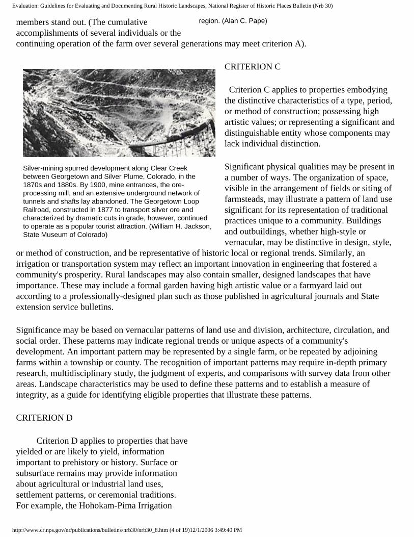
Silver-mining spurred development along Clear Creek between Georgetown and Silver Plume, Colorado, in the 1870s and 1880s. By 1900, mine entrances, the ore-processing mill, and an extensive underground network of tunnels and shafts lay abandoned. The Georgetown Loop Railroad, constructed in 1877 to transport silver ore and characterized by dramatic cuts in grade, however, continued to operate as a popular tourist attraction. (William H. Jackson, State Museum of Colorado)
CRITERION C
Criterion C applies to properties embodying the distinctive characteristics of a type, period, or method of construction; possessing high artistic values; or representing a significant and distinguishable entity whose components may lack individual distinction.
Significant physical qualities may be present in a number of ways. The organization of space, visible in the arrangement of fields or siting of farmsteads, may illustrate a pattern of land use significant for its representation of traditional practices unique to a community. Buildings and outbuildings, whether high-style or vernacular, may be distinctive in design, style,
or method of construction, and be representative of historic local or regional trends. Similarly, an irrigation or transportation system may reflect an important innovation in engineering that fostered a community's prosperity. Rural landscapes may also contain smaller, designed landscapes that have importance. These may include a formal garden having high artistic value or a farmyard laid out according to a professionally-designed plan such as those published in agricultural journals and State extension service bulletins.
Significance may be based on vernacular patterns of land use and division, architecture, circulation, and social order. These patterns may indicate regional trends or unique aspects of a community's development. An important pattern may be represented by a single farm, or be repeated by adjoining farms within a township or county. The recognition of important patterns may require in-depth primary research, multidisciplinary study, the judgment of experts, and comparisons with survey data from other areas. Landscape characteristics may be used to define these patterns and to establish a measure of integrity, as a guide for identifying eligible properties that illustrate these patterns.
CRITERION D
Criterion D applies to properties that have yielded or are likely to yield, information important to prehistory or history. Surface or subsurface remains may provide information about agricultural or industrial land uses, settlement patterns, or ceremonial traditions. For example, the Hohokam-Pima Irrigation
http://www.cr.nps.gov/nr/publications/bulletins/nrb30/nrb30_8.htm (4 of 19)12/1/2006 3:49:40 PM

Evaluation: Guidelines for Evaluating and Documenting Rural Historic Landscapes, National Register of Historic Places Bulletin (Nrb 30)
Although reforested, the abandoned fields and roads of Harrisville, New Hampshire, provide evidence of historic land division, agricultural practices, and social customs associated with the community's settlement and pre-industrial history. Stone walls, changes in vegetation, patterns of erosion and deposition, soil content, and remnant foundations are of primary interest to landscape archeologists who are examining patterns of land use or occupation for which there is little written documentation. (Duffy Monahon)
Canals in Arizona have provided information about the agricultural practices and engineering capabilities of the Hohokam culture from 1000-1450 A.D., and about the Pima Indians' reuse of the canals to irrigate crops in the 17th century.
Vegetation and landscape features may themselves provide archeological evidence. Pollen and soil studies, remote-sensing, and an examination of vegetation may provide valuable information about past uses or activities. The abandoned roadways, reforested fields, remnant stone walls, and farmstead clusters in Harrisville, New Hampshire, for example, indicate significant patterns of 18th and early 19th century land division and diversified agriculture. For additional guidance on historic archeological sites, see National Register Bulletin: Guidelines for Evaluating and Registering Historical Archeological Sites and Districts.
LANDSCAPE ARCHEOLOGY
It is relatively simple to determine when a building or structure has lost its structural integrity and any potential significance lies in its value as an archeological site. More difficult, however, is deciding when to treat a landscape as an archeological site. Abandoned land, when undisturbed by later development or construction, may retain surface or subsurface features that can provide information important to an understanding of historic or prehistoric activities. When land historically cleared and cultivated is reforested, visual qualities of the historic period are lost, yet landscape characteristics such as walls, ditches, roadways, streams, and canals may still be in place and capable of indicating important patterns of land use or organization.
Landscape archeology may involve the examination of characteristics such as walls, road remnants, trail ruts, foundations, and refuse sites. It may also draw information from observable patterns of erosion and vegetation. A number of techniques may be used: analysis of soil stratigraphy; analysis of pollens and other sediments through flotation and core sampling to determine planting patterns; surficial surveys to identify remnant vegetation, boundary demarcations, and evidence of land use; analyses of existing vegetation or plant succession; remote sensing to detect buried walls, foundations, and roadways; and excavation to uncover buried irrigation systems, canals, or planting beds.
Assessments of significance are based on a well-formulated research design that considers the historic
http://www.cr.nps.gov/nr/publications/bulletins/nrb30/nrb30_8.htm (5 of 19)12/1/2006 3:49:40 PM
Evaluation: Guidelines for Evaluating and Documenting Rural Historic Landscapes, National Register of Historic Places Bulletin (Nrb 30)
contexts for the study area. The research design needs to indicate the landscape characteristics that are represented in the site and the information the site is likely to provide about the landscape characteristics that shaped an area in history or prehistory. It must explain how the information will add to an understanding of the property. The lack of other sources of information, such as written records or intact properties, generally increases the importance of an archeological site.
CRITERIA CONSIDERATIONS
National Register criteria considerations require some rural properties to meet additional standards. These include properties owned by religious organizations, cemeteries, commemorative properties, reconstructed farms, ceremonial sites, grounds associated with birthplaces or graves, and areas predominated by landscape characteristics less than fifty years of age.
Properties, such as farms or estates owned by religious institutions, and rural areas that were the site of religious activities, such as ceremonies or camp meetings, are eligible if they derive their primary significance from the physical characteristics of the land or from the historical events that took place there. The birthplace or grave of an historical figure of outstanding importance, with any associated land, may be eligible if there is no other appropriate site or building directly associated with the individual's productive life. Cemeteries in rural areas may be eligible if their primary significance is derived from the graves of persons of transcendental importance, or from age, distinctive design, or association with historic events, such as a cemetery that is the only tangible remains of a community's pioneering period. A commemorative property may be eligible if design, age, tradition, or symbolic value has invested it with historical importance, for example, a State forest named for an important public figure may be important for its recreational or economic uses.
Farm museums that are reconstructions of farms or artificial assemblages of moved buildings are not eligible. Historically important farms or agricultural communities used as museums, may be eligible if their historic integrity has not been destroyed by new construction, moved buildings, or adaptive uses. Farm museums at least fifty years of age, whether reconstructions, assemblages, or original farms, may be eligible based on their significance as museums.
Continuity of land uses and cultural associations is a common concern in evaluating rural landscapes. Properties less than fifty years of age may be listed only if they are exceptionally important. The passage of time is necessary to recognize historic importance. This requirement applies to rural properties where a large proportion of buildings and structures were built or moved within the past 50 years, or where the predominant patterns of land use and division developed within the past 50 years. For guidance on evaluating exceptional importance, see National Register Bulletin: Guidelines for Evaluating and Nominating Properties That Have Achieved Significance Within the Past Fifty Years.
2. Select Areas of Significance
Area of significance is that aspect of history in which a rural property, through use, occupation, physical
http://www.cr.nps.gov/nr/publications/bulletins/nrb30/nrb30_8.htm (6 of 19)12/1/2006 3:49:40 PM

Evaluation: Guidelines for Evaluating and Documenting Rural Historic Landscapes, National Register of Historic Places Bulletin (Nrb 30)
character, or association, influenced the development or identity of its community or region. Although agriculture is most common, a number of other areas of significance may also apply, including industry in the case of mining or lumbering areas, conservation and recreation for parks and natural reserves, and transportation for migration trails. The area of significance is not necessarily the same as the general land use; for example, a farming community may be important in ethnic heritage but not in agriculture.
Several areas of significance apply to the physical qualities of a rural landscape. Community development and planning applies to areas reflecting important patterns of physical development, land division, or land use. Landscape architecture applies to properties based on established design principles or a conscious design. Architecture is used when significant qualities are embodied in the design, style, or method of construction of buildings and structures such as houses, churches, community buildings, barns, and outbuildings. Engineering applies to properties having significant systems of irrigation, drainage, transportation, or water power, as well as significant structures such as dams, bridges, tunnels, mining shafts, and fencing.
3. Define Period of Significance
Period of significance is the span of time when a property was associated with important events, activities, persons, cultural groups, and land uses, or when it attained important physical qualities or characteristics. Although it may be short, more often it extends many years, covering a series of events, continuum of activities, or evolution of physical characteristics. Properties may have more than one period of significance.
The period of significance begins with the date of the earliest land use or activity that has importance and is reflected by historic characteristics tangible today. The period closes with the date when the events, activities, and construction having historic importance ended. Properties that have evolved and achieved importance during separate periods, some spanning several hundred years, should be given several periods of significance. All landscape characteristics should be considered, since buildings and structures may date to one era, while roads, field patterns, and archeological sites may date to earlier ones.
Continuous land use, association, or function does not by itself justify continuing the period of significance. The length of time should be based on the years when the property historically made important contributions in the areas of significance. Fifty years ago may be used as the closing date for the period of significance if a more specific date cannot be identified.
AREAS OF SIGNIFICANCE FOR RURAL LANDSCAPES
The following areas of significance commonly apply to rural landscapes:
Agriculture, where the land has been used for cultivating crops, raising livestock, and other activities that have contributed to the growth, development, and economy of a community during particular periods of its history.
http://www.cr.nps.gov/nr/publications/bulletins/nrb30/nrb30_8.htm (7 of 19)12/1/2006 3:49:40 PM

Evaluation: Guidelines for Evaluating and Documenting Rural Historic Landscapes, National Register of Historic Places Bulletin (Nrb 30)
Architecture, where a collection of high-style or vernacular buildings and outbuildings are integrally related to large areas of landscape by historical association, function, design, spatial arrangement, or setting; and are indicative of the physical development, materials, or land uses of a State, region, or community, or the building practices or traditions of the people who occupied it.
Archeology, where patterns visible upon the land or evident in subsurface remains can provide important information about land use and occupation of prehistoric or historic peoples.
Community Planning and Development, where the spatial organization and character of the landscape are the result of either a consciously designed plan or vernacular patterns of land use or land division.
Conservation, where the landscape has been the subject of an important stage, event, or development in the conservation of natural or cultural resources.
Engineering, where the landscape and its uses reflect the practical application of scientific principles to serve human needs, such as reclamation, irrigation, and water power.
Exploration/Settlement, where the landscape continues to reflect the exploration, establishment, or early development of a community or region.
Industry, where the landscape has been shaped or manipulated to provide goods or services, through activities such as lumbering, mining, milling and quarrying, that have contributed to the development of a community or society in general.
Landscape Architecture, where the landscape contains sites--including gardens, farmyards, and parks--that have been based on established design principles or conscious designs, or are the work of a master, having importance within the context of landscape design.
Science, where the landscape has been the subject of research related to the advancement or understanding of agriculture, horticulture, silviculture, animal husbandry, or other scientific disciplines.
Assessing Historic Integrity
Historic integrity is the composite effect of seven qualities: location, design, setting, materials, workmanship, feeling, and association. Decisions about historic integrity require professional judgments about whether a property today reflects the spatial organization, physical components, and historic associations that it attained during the periods of significance. A property's periods of significance become the benchmark for measuring whether subsequent changes contribute to its historic evolution or alter its historic integrity.
Historic integrity requires that the various characteristics that shaped the land during the historic period
http://www.cr.nps.gov/nr/publications/bulletins/nrb30/nrb30_8.htm (8 of 19)12/1/2006 3:49:40 PM

Evaluation: Guidelines for Evaluating and Documenting Rural Historic Landscapes, National Register of Historic Places Bulletin (Nrb 30)
be present today in much the same way they were historically. No landscape will appear exactly as it did fifty or one hundred years ago. Vegetation grows, land use practices change, and structures deteriorate. The general character and feeling of the historic period, however, must be retained for eligibility. Historical vistas that have remained open often provide a general vantage point for evaluating change. Historic and contemporary views may be compared through old photographs, diary entries, and letters.
Depending on significance, the presence of some characteristics is more critical to integrity than others. Vegetation and land uses are important to an area historically significant for grazing and cropping, while landforms and circulation networks may be essential to a mining community. The integrity of a significant collection of vernacular stone construction may rely heavily on the condition of boundary walls, farmhouses, barns, outbuildings, bridges, and community buildings. Boundary demarcations, early roadways, clusters, and small-scale elements may be necessary to depict the significant patterns of settlement and field arrangements in an ethnic community.
Setting is the physical environment within and surrounding a rural historic landscape. A fertile 40 square-mile basin atop 4,000-foot Garden Mountain, Burke's Garden Historic District, Tazewell County, Virginia, contains the material culture of occupations and agricultural activities from 8000 B.C. to teh present. The district lies in the forested and sparsely settled highlands of the Southern Appalachians. (Virginia Department of Historic Resources)
1. Apply Qualities of Integrity
Because of the overriding presence of land, natural features, and vegetation, the seven qualities of integrity called for in the National Register criteria are applied to rural landscapes in special ways.
The relationship of landscape characteristics and integrity is complex. Patterns of spatial organization, circulation networks, and clusters directly relate to design and strongly influence the cohesiveness of a landscape. Boundary demarcations, small-scale elements, vegetation, and the evidence of responses to the natural environment all add to location and setting as well as design. Continuing or compatible land uses and activities enhance integrity of feeling and association. Buildings and structures, vegetation, small-scale elements, and land uses all reflect materials, workmanship, and design. Archeological sites may strengthen integrity by providing physical evidence of activities no longer practiced.
Location is the place where the significant activities that shaped a property took place. Geographical factors, including proximity to natural resources, soil fertility, climate, and accessibility, frequently determined the location of rural settlements. In some places, these factors have continued to spur growth and development. In others, they have insulated communities from change, fostering the preservation of historic characteristics, practices, and traditions. A rural landscape whose characteristics retain their historic location has integrity of location.
Design is the composition of natural and cultural elements comprising the form, plan, and spatial organization of a property. Design results from conscious and unconscious decisions over time about
http://www.cr.nps.gov/nr/publications/bulletins/nrb30/nrb30_8.htm (9 of 19)12/1/2006 3:49:40 PM

Evaluation: Guidelines for Evaluating and Documenting Rural Historic Landscapes, National Register of Historic Places Bulletin (Nrb 30)
where areas of land use, roadways, buildings and structures, and vegetation are located in relationship to natural features and to each other. Design also relates to the functional organization of vegetation, topography, and other characteristics, for example, upland pastures bounded by forested hillsides and windbreaks sheltering fields or orchards.
New vegetation or reforestation may affect the historic integrity of design. Changes in land use may not seriously alter integrity if historic boundary demarcations, circulation networks, and other components remain in place. Shifts in land use from wheatfield to pasture or the introduction of contour plowing may not seriously affect the overall design, whereas the extensive irrigation and planting of fruit trees on land historically used for cattle grazing would.
Setting is the physical environment within and surrounding a property. Large-scale features, such as bodies of water, mountains, rock formations, and woodlands, have a very strong impact on the integrity of setting. Small-scale elements such as individual plants and trees, gateposts, fences, milestones, springs, ponds, and equipment also cumulatively contribute to historic setting.
Materials within a rural property include the construction materials of buildings, outbuildings, roadways, fences, and other structures. The presence of native minerals, stone, and even soil can add substantially to a rural area's sense of time and place. These may be present in natural deposits or built construction.
Vegetation, as material, presents a complex problem. Plants do not remain static but change over time and have a predictable lifespan. While hardwoods and evergreens thrive for decades, most crops are seasonal and demand rotation. Plants and trees are subject to blights and disease and may be damaged by weather and climatic changes. Furthermore, the relationships among plant species vary over time due to differing growth patterns and lifespans, animal grazing behavior, and changes in soil conditions. Soil exhaustion, erosion, improper crop rotation, availability of water, and pollution may affect soil productivity and alter the succession of vegetation.
Original plant materials may enhance integrity, but their loss does not necessarily destroy it. Vegetation similar to historic species in scale, type, and visual effect will generally convey integrity of setting. Original or in-kind plantings, however, may be necessary for the eligibility of a property significant for specific cultivars, such as a farm noted for experiments in the grafting of fruit trees.
Workmanship is exhibited in the ways people have fashioned their environment for functional and decorative purposes. It is seen in the ways buildings and fences are constructed, fields are plowed, and crops harvested. The workmanship evident in the carved gravestones of a rural cemetery endures for a long time. Although the workmanship in raising crops is seasonal, it does contribute to a property's historic integrity if it reflects traditional or historic practices.
Feeling, although intangible, is evoked by the presence of physical characteristics that reflect the historic scene. The cumulative effect of setting, design, materials, and workmanship creates the sense of past time and place. Alterations dating from the historic period add to integrity of feeling while later ones do not.
Association is the direct link between a property and the important events or persons that shaped it. Integrity of association requires a property to reflect this relationship. Continued use and occupation help
http://www.cr.nps.gov/nr/publications/bulletins/nrb30/nrb30_8.htm (10 of 19)12/1/2006 3:49:40 PM

Evaluation: Guidelines for Evaluating and Documenting Rural Historic Landscapes, National Register of Historic Places Bulletin (Nrb 30)
maintain a property's historic integrity if traditional practices are carried on. Revived historic practices, traditional ceremonies or festivals, use of traditional methods in new construction, and continuing family ownership, although not historic, similarly reinforce a property's integrity by linking past and present. New technology, practices, and construction, however, often alter a property's ability to reflect historic associations.
Original plant materials, such as teh filbert trees, at Dorris Ranch in Lane County, Oregon, enhance the significance of a rural landscape. Their presence is especially important to the integrity of landscapes significant for the cultivation and productivity of plants having lengthy life spans. (Willamalane Park and Recreation District)
2. Identify Changes and Threats to Integrity
Historic integrity is threatened by single major changes such as large scale farming practices that obliterate historic field patterns, flatten the contours of the land, and erase historic boundary markers, outbuildings, and fences. Integrity may also be lost due to the cumulative effect of relocated and lost historic buildings and structures, interruptions in the natural succession of vegetation, and the disappearance of small-scale features that defined historic land uses.
The following changes, when occurring after the periods of significance, may reduce the historic integrity of a rural landscape:
● abandonment and realignment of roadways and canals ● widening and resurfacing of historic roadways ● changes in land use and management that alter vegetation, change the size and shape of fields,
erase boundary demarcations, and flatten the contours of land ● modern methods of mining that leave large open pits or massive tailings uncharacteristic of
historically significant extraction methods ● introduction of nonhistoric land uses (quarries; tree farms; sanitary landfill; recreational areas;
limited access highways and interchanges; power plants, wastewater treatment plants, and other public utilities; subdivision for residential, commercial, or industrial development)
● loss of vegetation related to significant land uses (blights, abandonment, new uses, reforestation, and introduction of new cultivars)
● deterioration, abandonment, and relocation of historic buildings and structures ● substantial alteration of buildings and structures (remodeling, siding, additions) ● replacement of structures such as dams, bridges, and barns ● construction of new buildings and structures ● disturbance of archeological sites (bulldozing, earth removal, highway construction, nonscientific
excavation) ● loss of boundary demarcations and small-scale features (fences, walls, ponds, and paving stones)
3. Classify Contributing and Noncontributing Resources
http://www.cr.nps.gov/nr/publications/bulletins/nrb30/nrb30_8.htm (11 of 19)12/1/2006 3:49:40 PM

Evaluation: Guidelines for Evaluating and Documenting Rural Historic Landscapes, National Register of Historic Places Bulletin (Nrb 30)
Buildings, structures, objects, and sites are classified as contributing or noncontributing based on their historic integrity and association with a period and area of significance. Those not present during the historic period, not part of the property's documented significance, or no longer reflecting their historic character are noncontributing.
Criteria considerations may affect the classification of religious properties, moved structures, birthplaces and graves, cemeteries, reconstructions, commemorative properties, and properties less than fifty years of age. These may contribute as integral parts of districts, that is, resources that relate, by date and function, association, or character, to the historic significance of the overall property. Examples include: a church founded by an ethnic group that settled an area, a corncrib moved during the period of significance to serve a farm's ongoing evolution, a rural cemetery where generations of local families are buried, and a historic war memorial within a village green.
Reconstructed fields and orchards, as well as buildings and structures, may contribute if suitably located and accurately executed according to a restoration master plan.
Buildings and structures built or moved within the past fifty years generally do not contribute. They affect historic integrity by altering the historic relationships of buildings, structures, and land areas, and by disrupting historic patterns of land division and organization. Recent agricultural buildings--whether built by traditional methods or in modern forms and materials, such as Harvestor silos or corrugated metal hay barns--may be recognized as contributing when sufficient time has lapsed to consider them integral parts of the historic landscape.
Modern-day quarrying in Oley Township, Pennsylvania, bears little relationship to historic practices. The operations and the ever-growing pits and tailings they create threaten the district's historic integrity. Despite new quarries and residential subdivisions, Oley Township was listed in teh National Register in its entirety, because 90 percent of teh 15,000 acres retained teh historic pastoral and agricultural character. (Oley Resource Conservation Project)
4. Weigh Overall Integrity
The final decision about integrity is based on the condition of the overall property and its ability to convey significance. The strength of historic landscape characteristics and the nature, extent, and impact of changes since the periods of significance are important factors to consider.
Integrity depends to a substantial degree on the area's historic contexts. This information indicates the extent of integrity that can be expected for a particular type of historic property given the unique aspects, cultural and natural, of the area and the condition of comparable properties. The survival of significant characteristics, such as field patterns and boundary demarcations, that in other areas have been lost can make a rural property significant despite the deterioration of its buildings and loss of outbuildings.
Loss or relocation of a few features usually does not affect a rural property's overall historic integrity.
http://www.cr.nps.gov/nr/publications/bulletins/nrb30/nrb30_8.htm (12 of 19)12/1/2006 3:49:40 PM

Evaluation: Guidelines for Evaluating and Documenting Rural Historic Landscapes, National Register of Historic Places Bulletin (Nrb 30)
But the repeated loss of buildings, structures, roadways, and small-scale elements, as well as gradual changes to boundaries and land uses, may cumulatively destroy integrity.
New construction and incompatible land uses covering extensive acreage such as residential subdivisions, modern mining or quarrying operations, refuse dumps and land fill, limited access highways and their interchanges cause the greatest damage. Not only do they introduce major visual intrusions and interrupt the continuity of the historic scene, but they reshape the land, disturb subsurface remains, and introduce ahistorical characteristics.
Large rural districts may be able to absorb new development and still maintain their overall historic integrity, provided large-scale intrusions are concentrated in a relatively few locations and cover a proportionately small percentage of the overall acreage. For example, the 15,000 acres of Oley Township Historic District, Pennsylvania, maintain a strong sense of the agricultural activities begun in the 18th and 19th centuries despite the presence of several sizable modern quarries, a large housing subdivision, and contemporary houses along roadways. While the new development is noncontributing it occurs in isolated pockets and covers only ten percent of a historic district otherwise characterized by cultivated fields and scattered farmsteads.
Selecting Boundaries
The boundaries of South Lima Township Rural District, Michigan, are based on property lines, most of which coincide with the historic rectangular grid of the Midwest. Peripheral farms were included or excluded on the basis of their historic integrity. (Lynda Koch)
Boundaries for rural historic landscapes must encompass the area having historic significance, rather than just scenic values, and contain contributing resources that express the characteristics of the historic landscape. For this reason, all of the acreage making up a rural site or district should be reviewed through either an onsite survey or aerial photography.
1. Define the historic property
The historic property is the unit of land actively managed, occupied, settled, or manipulated during the historic period for purposes related to significance.
In the development of historic contexts, the types of historic properties for an area were identified. This information helped determine the study area and focus research and survey activities on specific properties. As facts were associated with existing historic landscape characteristics, the existence of historic properties or portions of them were verified.
Historic properties may be evaluated at various geographical scales. A rural property, such as a farm, may have its own significance, but also be part of a significant collection of neighboring farms or an
http://www.cr.nps.gov/nr/publications/bulletins/nrb30/nrb30_8.htm (13 of 19)12/1/2006 3:49:40 PM

Evaluation: Guidelines for Evaluating and Documenting Rural Historic Landscapes, National Register of Historic Places Bulletin (Nrb 30)
entire community with a village cluster, outlying farms, and interconnecting roads, that form larger historic districts. The initial step in selecting the boundaries of a rural historic landscape is to determine the extent to which properties at the smallest scale, such as a single farm, are intact and form larger properties that may be listed as large and cohesive historic districts.
If the study area was based on a historic property clearly defined by physical characteristics, historic ownership, or concentration of activity, National Register boundaries may vary little from those of the area studied. In cases, however, where a large area was studied, such as a township or county, with the purpose of identifying eligible properties, a number of properties of varying scales and boundaries may be defined, for example, a large village district and several outlying farms and mill sites.
On September 17, 1862, "Bloody Lane" witnessed some of the most intense fighting of teh Civil War. Continuing agricultural land uses and the historic integrity of the sunken farm lane and adjoining fields evoke the historic scene in a photograph taken in August 1934. Monuments along the lane mark commemorative activities that occurred at Antietam National Battlefield in the late 19th and early 20th centuries. (Allan Rinehart, National Park Service History Collection)
2. Decide what to include
National Register boundaries must encompass a concentration or continuity of historic landscape characteristics. Many properties will not retain their historic property lines or possess significant characteristics throughout. The next step in selecting boundaries is deciding what land within the historic property today has both historic significance and integrity.
Information from survey and research--including historic land uses, dates of buildings and other components, and changes since the period of significance--can indicate to what extent the historic property was actively used and today reflects that use. Consulting historic
maps, land plats, aerial photographs, land grant records, property deeds, and oral history data can help determine the evolution of the historic property. The overlaying of transparent maps of the same scale to represent various stages of development, including the current condition, is useful for comparing changes over time and for arriving at boundaries. Geographic Information Systems (GIS) can also be used for this purpose.
Continuity is essential. Historic landscape characteristics should predominate and occur throughout. Peripheral areas having a concentration of nonhistoric features should be excluded, while the impact of centrally located ones on historic integrity should be considered. If, because of their density, distribution, and predominance, nonhistoric features seriously fragment the overall historic integrity of large-scale properties, smaller properties having integrity should be identified for listing. This applies, for example, to individual farmsteads in an agricultural community that is experiencing rapid and widespread suburbanization.
Buffer zones or acreage not related to historic use are excluded from National Register listings, but may be considered in planning and protection. These include natural features that fall within significant
http://www.cr.nps.gov/nr/publications/bulletins/nrb30/nrb30_8.htm (14 of 19)12/1/2006 3:49:40 PM

Evaluation: Guidelines for Evaluating and Documenting Rural Historic Landscapes, National Register of Historic Places Bulletin (Nrb 30)
historic vistas but were not actively used, managed, or controlled by historic land use or ownership. Also excluded are nonhistoric areas of compatible or similar land use adjoining a historic area--for example, land recently cleared and placed into agricultural use.
Natural features may be included if they are centrally located within the landscape, such as a hill or stream, or if they were actively used for purposes related to historic significance, for example, forests historically used for woodlots, and wetlands used for foraging wild berries.
Peripheral land that provides historic setting, such as forested hillsides or rock escarpments, may be included only if the historic record indicates that the land was historically an integral part of the property being nominated. Such an integral relationship can be established through common historic ownership, the role of the peripheral land in significant land uses or community development, or a passive function such as providing a barrier for defense or protection from wind and weather.
3. Select Appropriate Edges
Edges may be defined in several ways. Legal boundaries, based on historic ownership, land use, or incorporation, should be used where a historic property remains intact and is significant in its entirety. Natural features such as bodies of water, ridgelines, and sharp rises in elevation often form edges that have historically separated areas having different land uses. In areas undergoing widespread change, edges, based on current ownership, may be drawn to exclude new land uses or incompatible development. When none of the approaches listed in Defining the Edges of a Rural Landscape fit a situation, a certain degree of professional judgment will be needed to define an edge--for example, a line drawn between the end of a stone wall and a hedge row that, while somewhat arbitrary, can still be justified.
Edges should be appropriate to the location, historic significance, and integrity of the property. A natural stream and field demarcations may work well in the Piedmont region, while quarter sections of a USGS map are more logical in rural Minnesota where land was divided according to the national rectangular survey.
http://www.cr.nps.gov/nr/publications/bulletins/nrb30/nrb30_8.htm (15 of 19)12/1/2006 3:49:40 PM

Evaluation: Guidelines for Evaluating and Documenting Rural Historic Landscapes, National Register of Historic Places Bulletin (Nrb 30)
Pictorial evidence is valuable for charting teh evolution of a rural landscape and verifying its historic integrity. Comparative views of Ebey's Prairie, Washington, photographed about 1900 and 1983, indicate little change in the division of land, agricultural land uses, and arrangement of the farmyard cluster. (Pacific Northwest Regional Office, National Park Service)
Several approaches may be combined. An agricultural district, for example, might be bounded by a natural river, the political boundaries of a national forest, the limits of a modern development, and, where intact, the legal boundaries of historic parcels. Whatever the approach, boundaries must be fixed in space and capable of accurate description by metes and bounds, legal descriptions, lines appearing on USGS topographical maps, or site plans drawn to scale.
Settlement and agricultural development occurred within the fertile floodplain of teh Nacoochee Valley, Georgia. To encompass the land area actively farmed during the historic period, district boundaries included approximately 2,500 acres and were drawn along the 1,400-foot contour line on teh USGS topographical map. (photo: James R. Lockhart; map: Georgia Department of Natural Resources)
DEFINING THE EDGES OF A RURAL LANDSCAPE
The following are commonly used to define the edges of rural historic landscapes:
Historic legal boundaries of a single property, a group of properties, or an entire political jurisdiction when the historic property possesses continuity of historic landscape characteristics throughout, even though the ownership or division of land may have changed.
Boundary demarcations that are relatively permanent, such as stone fences, irrigation or drainage ditches, and mature hedge rows, when such barriers are based on historic land use or ownership and encompass the concentration of related historic landscape characteristics.
Rights-of-way, such as roads, established paths, and highways, when they separate areas of land that are historically significant from those that are either unrelated, insignificant, or not historic.
Natural features, such as rivers, lakeshores, ridges, plateaus, and contour elevations when such features limited the historic development of the land and continue to contain historic landscape characteristics.
http://www.cr.nps.gov/nr/publications/bulletins/nrb30/nrb30_8.htm (16 of 19)12/1/2006 3:49:40 PM
Evaluation: Guidelines for Evaluating and Documenting Rural Historic Landscapes, National Register of Historic Places Bulletin (Nrb 30)
Changes in nature of development or spatial organization, such as the departure of a community having vast tracts of communally owned farmland from the typical Midwestern grid of 160-acre farms, when differences are related to significance.
Edges of new development, such as modern housing, limited access highways, or industrial parks.
Current legal boundaries, when they coincide with the area retaining historic landscape characteristics today. Acreage may be the same or smaller than that within the historic boundaries.
Lines drawn along or between fixed points, such as stone walls, shorelines, or the intersection of two roads, when they contain the area retaining historic landscape features.
Long-standing vegetation that is visible at all seasons, such as a row of hardwoods, when it marks the edge of the area containing historic landscape characteristics.
CONSIDERATIONS IN EVALUATING RURAL HISTORIC LANDSCAPES
This section provides additional guidance for evaluating certain types of properties that either meet the definition of a rural historic landscape or possess historic landscape characteristics.
Properties Having Significant Patterns of Folklife
Historically established patterns of folklife may be perpetuated by the people living in rural properties today. These include traditional customs, crafts, or land use practices that have historic origins and have been passed from one generation to another.
Tangible characteristics may reflect traditional materials, craftsmanship, or functions, such as a cider-press, a community hall, or communally-owned fields. When these date to the historic period, they may contribute to areas of significance such as ethnic heritage, art, architecture, community planning and development, or social history.
Seasonal, short-lived, or recent expressions of folklife are seen in haystacking, using traditional techniques for new construction, and observing traditional customs. While these do not date to the historic period, they do enhance integrity of setting, feeling, and association.
Traditional Cultural Properties
Native Americans and other cultural groups have commonly used natural features or sites for religious, ceremonial, or hunting and gathering activities. Although landscape characteristics may be useful for describing the natural setting of these places, an in-depth study of characteristics is not necessary where traditional uses have not altered the land. For further guidance in evaluating landscapes possessing traditional values, see National Register Bulletin: Guidelines for Evaluating and Documenting
http://www.cr.nps.gov/nr/publications/bulletins/nrb30/nrb30_8.htm (17 of 19)12/1/2006 3:49:40 PM

Evaluation: Guidelines for Evaluating and Documenting Rural Historic Landscapes, National Register of Historic Places Bulletin (Nrb 30)
Traditional Cultural Properties.
Trails and Roads
Trails and roads require verification that the land nominated is the actual location of the trail. Eligibility requires integrity of setting and location. Boundaries commonly encompass the length and width of the byway and a margin of land, for example, 40 feet, on both sides. Boundaries may be widened to take in encampment sites, mountain passes, fords across streams, and sites marked by trail ruts, arroyos, and surface disturbances associated with historic activity. Boundaries may also include land that forms a historically important and intact setting, for example, the hillsides and rock formations rising from an important pass on a frontier trail. Where the continuity of a byway has been interrupted by nonhistoric development, segments retaining significance and integrity can be nominated together in a multiple property submission.
Battlefields and Encampments
Battlefields, encampments, and other areas where short-term historic events took place may possess important landscape characteristics. Although the significance of these properties does not directly relate to land use, their historic integrity depends upon landscape characteristics such as natural features, land uses, vegetation, and associated buildings and structures. Furthermore, their location may have been determined by natural features, proximity to railroads, land uses, circulation networks, and cultural traditions. When these properties have been preserved for many years, they may have additional significance for patterns of land use and division that have elsewhere disappeared.
Scenic and Recreational Parks
State, county, and national parks set aside for recreational and scenic purposes are designed landscapes to the extent that roads, trails, buildings, vegetation, and other features were developed according to a master plan. These landscapes, due to their location, extensive acreage, purpose, and management, also have the characteristics of a rural landscape. Park features, such as trails, bridges, campgrounds, native flora, cabins, and scenic overlooks, can be meaningfully examined using the system of landscape classification. Circulation networks, response to natural environment, land uses and activities, vegetation related to land use, clusters, and small scale features are particularly useful in documenting these properties.
Mining Properties
Mining properties may include not only the most prominent mining structures, but also the communities shaped as a result of the mining activity and the surrounding land covered by related mining claims and containing historic shafts, tunnels, pits, and tailings. Landscape characteristics can be used to describe and evaluate these properties.
Modern methods of extraction may alter integrity. While the historic presence of tailings may be viewed as part of the historic setting, modern tailings and excavation, with or without recent structures, threaten
http://www.cr.nps.gov/nr/publications/bulletins/nrb30/nrb30_8.htm (18 of 19)12/1/2006 3:49:40 PM

Evaluation: Guidelines for Evaluating and Documenting Rural Historic Landscapes, National Register of Historic Places Bulletin (Nrb 30)
historic integrity. Open pit mining in an area historically mined through tunnels and shafts destroys historic characteristics, altering an area's historic integrity. However, an open pit mine that has operated since the historic period retains its integrity, if recent extraction methods have been similar to those practiced historically and if the character of the pit is similar, although greater in size, to that of the historic period.
Lumbering Communities
Historic lumbering communities may contain scattered remains of logging activities and forests in varying stages of reforestation. Current tree cover often varies in species and age from historic vegetation. Abandoned areas frequently reflect the natural plant succession that follows cutting, making it impossible to define the visual quality of historic setting. For these reasons, significance depends on an understanding of changing patterns of vegetation and the presence of other characteristics, such as roadways, logging equipment and structures, workers' camps, and transportation facilities.
National Register Home | Publications Home | Previous Page | Next Page
Comments or Questions
JPJ
http://www.cr.nps.gov/nr/publications/bulletins/nrb30/nrb30_8.htm (19 of 19)12/1/2006 3:49:40 PM

Registration: Guidelines for Evaluating and Documenting Rural Historic Landscapes, National Register of Historic Places Bulletin (Nrb 30)
U.S. Department of the Interior, National Park Service National Register, History and Education
The Carol Parins Farmstead (no. 25 below) represents the traditional Belgian-American farm in the U-shaped configuration of teh barnyard, numerous log outbuildings, and outlying fields. (Bill Tishlir)
REGISTRATION
Nominations are made on the National Register Registration Form (NPS 10-900) and processed according to the regulations set forth in 36 CFR Part 60. Where the study of rural area identifies several properties eligible for listing and related by common historic contexts, the National Register Multiple Property Documentation Form (NPS 10-900-b) is used to document the contexts, property types, and methodology; separate registration forms then document each eligible property.
The following guidance supplements National Register Bulletin: How to Complete the National Register Registration Form and is organized according to the section names on the registration form. The form is intended as a summary of the information gathered during identification and a synthesis of findings concerning significance, integrity, and boundaries.
Classification
A rural property containing a collection of sites, structures, buildings, or objects is
http://www.cr.nps.gov/nr/publications/bulletins/nrb30/nrb30_9.htm (1 of 4)12/1/2006 3:50:01 PM

Registration: Guidelines for Evaluating and Documenting Rural Historic Landscapes, National Register of Historic Places Bulletin (Nrb 30)
Sketch maps of two scales were used to record the Namur Belgian-American District in Door County, Wisconsin. A large map drawn to a small scale covers the entire district and locates district boundaries, roads and farm clusters. Small maps drawn to a larger scale and keyed by number to the district map then identify the contributing and noncontributing buildings and structures in each farm cluster.
classified as a district. A rural property containing land with no buildings, objects, or structures--such as a wildlife preserve or a camp meeting ground--is classified as a site. Contributing and noncontributing resources are counted according to the guidelines in Bulletin 16A. Acreage with component land areas, such as forests, orchards, fields, or pasture, counts as a single continuous site. Buildings, structures, objects, and sites within the landscape that are substantial in size and scale or are specifically discussed as significant are counted separately.
Other landscape characteristics, including areas of natural vegetation, fences, walls, plantings, ponds, and drainage ditches, are considered integral parts of the overall site. It is appropriate to count them separately if they form a structure or site that is substantial in size, scale, or importance--such as a network of historic roads, an irrigation system, a designed park, or a significant orchard.
Function
Data categories for agriculture, landscape, transportation, industry, and recreation and culture, include a number of subcategories that apply to land uses and activities. These should be listed along with those relating to buildings and structures.
Description
The description defines the historic property being registered and describes the evolution and current condition of its landscape characteristics. The processes that have shaped the landscape are discussed and related to specific features within the property. Changes that have occurred in the use and character of the land should be dated as accurately as possible. Threats to integrity should be described and their impact on the historic character of the landscape discussed. The section Documentation of Landscape Characteristics lists the information to be included for each characteristic.
Information about historic landscape characteristics should be organized to best portray the character of the property. For a large district, it may be logical to discuss the general character of the district, and then separately treat the circulation networks, large-scale irrigation systems, village clusters, and smaller properties contained within it. For other properties, it may make most sense to describe the landscape characteristics by type, and to discuss land use areas, structures, and buildings individually rather than as parts of clusters or small units of property.
Specialized terminology may be necessary. Botanical or geological terms not commonly understood
http://www.cr.nps.gov/nr/publications/bulletins/nrb30/nrb30_9.htm (2 of 4)12/1/2006 3:50:01 PM

Registration: Guidelines for Evaluating and Documenting Rural Historic Landscapes, National Register of Historic Places Bulletin (Nrb 30)
should be explained. Common names, such as Corvallis cherry or Longhorn cattle, are sufficient to identify vegetation and livestock. Scientific names should however, be used when common botanical names are inadequate to describe plant diversity or significant cultivars. Commonly understood terms should be used to describe vernacular patterns of construction, land use, or land division. When terms that are regional or ethnic in derivation are used to describe land use practices, construction methods, or cultural customs, they should be explained.
Significance
The statement of significance explains the ways in which the property, through its land uses and characteristics, directly relates to specific historic contexts, National Register criteria, areas and periods of significance, and, if applicable, criteria considerations. Important activities, events, persons, or physical qualities are discussed in relationship to specific features identified by the landscape characteristics. The statement of historic contexts, revised, as appropriate, based on the findings of survey, research, and evaluation, is included.
The greater the importance of certain landscape characteristics, the more factual and detailed the discussion of their role and evolution should be. For example, if transportation is an area of significance, the circulation networks will require greater explanation; if community development and planning is an area of significance, patterns of land division and use should be discussed.
Major Bibliographical References
A standard bibliographical style is used to cite sources including books, magazine articles, maps, atlases, historic photographs, local histories, studies on soils and vegetation, archeological reports, and geological studies. References to oral histories should give the date of the interview and the name and affiliation of both the person being interviewed and the interviewer. Collections of photographs, oral history tapes or transcripts, personal records, and maps that are not available in published sources should be cited by name and location.
Boundaries
Boundaries are described as accurately as possible using metes and bounds, legal descriptions, tax parcel numbers, lines and sections on USGS maps, or lines on a map drawn to a scale no smaller than 1 inch = 200 feet. See Defining the Edges of a Rural Landscape.
Maps
A detailed sketch map is required for all properties meeting the definition of historic district. The map indicates the boundaries of the property and locates the principal landscape characteristics. Buildings and structures, circulation networks, major land uses, archeological sites, prominent natural features, and large areas of vegetation should be marked on the map. Each building, structure, object, and site that is substantial in size, scale, or importance should be labeled by name, number, or other symbol, and marked as contributing or noncontributing. Refer to the section Documentation of Landscape Characteristics for
http://www.cr.nps.gov/nr/publications/bulletins/nrb30/nrb30_9.htm (3 of 4)12/1/2006 3:50:01 PM

Registration: Guidelines for Evaluating and Documenting Rural Historic Landscapes, National Register of Historic Places Bulletin (Nrb 30)
additional guidance.
For properties with large acreage, several maps drawn to different scales may be used in place of one overall sketch map. A small-scale map, such as a USGS topographic map in the 1:24,000 series, could cover the overall property and indicate boundaries and principal areas of land use, natural features, circulation networks, isolated buildings and structures, and clusters. Maps drawn to a larger scale, for example, 1 inch = 200 feet, could then show the location of buildings, structures, and other features within each cluster. Large-scale maps should be cross- referenced as inserts to the area map.
Separate maps may also be used to locate archeological sites, land use areas, road systems or other transportation systems, and buildings and structures. A series of maps may show the evolution of the property at various periods of time.
Photographs
Representative views of historic and nonhistoric land areas and landscape characteristics, as well as buildings, structures, and clusters, must be submitted with the registration form. Copies of historical photographs, engravings, and illustrations may also be included. Contemporary photographs taken from the vantage point of historical photographs may supplement the written description of land changes.
National Register Home | Publications Home | Previous Page | Next Page
Comments or Questions
JPJ
http://www.cr.nps.gov/nr/publications/bulletins/nrb30/nrb30_9.htm (4 of 4)12/1/2006 3:50:01 PM

Recommended Reading: Guidelines for Evaluating and Documenting Rural Historic Landscapes, National Register of Historic Places Bulletin (Nrb 30)
U.S. Department of the Interior, National Park Service National Register, History and Education
RECOMMENDED READING AND SOURCES
List of National Register Bulletins
Books and Articles
Alanen, Arnold R. "Grounded in Reality: The Importance of Vernacular Landscapes." Courier 34 (August 1989): 10-13.
-----., and William H. Tishler. "Finnish Farmstead Organization in Old and New World Settings." Journal of Cultural Geography 1 (Fall/Winter 1980): 66-81.
Allen, Barbara. Homesteading in the High Desert. Salt Lake City: University or Utah Press, 1987.
Appleton, Jay. The Experience of Landscape. New York: John Wiley, 1975.
Austin, Richard, and Suzanne Turner, Robert Z. Melnick, and Thomas J. Kane, eds. Yearbook of Landscape Architecture: Historic Preservation. New York: Van Nostrand Reinhold, 1983.
Bidwell, Percy W. and John 1. Falconer. History of Agriculture in the Northern United States, 1620-1860. Clifton, NJ: A.M. Kelley, 1973.
Brockway, Lucinda. "Nominating New Hampshire Rural Districts to the National Register: A Professional Handbook." Concord, NH: State of New Hampshire Division of Historical Resources, 1987.
Carter, Thomas, and Carl Fleischhauer. The Grouse Creek Cultural Survey: Integrating Folklife and Historic Preservation Field Research. Washington, DC: Library of Congress, 1988.
http://www.cr.nps.gov/nr/publications/bulletins/nrb30/nrb30_10.htm (1 of 7)12/1/2006 3:50:24 PM

Recommended Reading: Guidelines for Evaluating and Documenting Rural Historic Landscapes, National Register of Historic Places Bulletin (Nrb 30)
Cochrane, Willard W. The Development of American Agriculture: A Historical Analysis. Minneapolis: University of Minnesota Press, 1979.
Cronon, William. Changes in the Land: Indians, Colonists, and the Ecology of New England. New York: Hill and Wang, 1984.
Cutler, Phoebe. The Public Landscape Of the New Deal. New Haven, CT: Yale University Press, 1985.
Danhof, Clarence H. Change in Agriculture: The Northern United States, 1820-1870. Cambridge: Harvard University Press, 1969.
Daniel, Pete. Breaking the Land: The Transformation of Cotton, Tobacco, and Rice Cultures since 1880. Urbana: University of Illinois Press, 1985.
Ebeling, Walter. The Fruited Plain: The Story of American Agriculture. Berkeley and Los Angeles: University of California, 1979.
Edwards, David A., and E. Randolph Turner. "Burke's Garden: Discovering Our Rural Heritage." Notes on Virginia 28 (Spring 1986): 15-19.
Eiseley, Jane, and William H. Tishler. "The Honey Creek Swiss Settlement in Sack County: An Expression of Cultural Norms in Rural Wisconsin." Wisconsin Magazine of History 73 (Autumn 1989): 3-20.
Firth, Ian. Biotic Cultural Resources: Management Considerations for Historic Districts in the National Park System, Southeast Region. Atlanta, GA: U.S. Department of the Interior, National Park Service, 1985.
Fly, Everett L., and La Barbara Wigfall Fly. "Ethnic Landscapes Come to Light." Landscape Architecture 77 (July/August 1987): 34-39.
Gates, Paul. The Farmer's Age: Agriculture, 1815-1860. New York: Holt, Rinehart, and Winston, 1960.
-----. Landlords and Tenants on the Prairie Frontier: Studies in American Land Policy. Ithaca, NY: Cornell University Press, 1973.
Hagood, Margaret Jarman. Mothers of the South: Portraiture of the White Tenant Farm Woman. Chapel Hill: University of North Carolina Press, 1939.
Hart, John Fraser. The Look of the Land. Englewood Cliffs, NJ: Prentice Hall, 1983.
Jackson, John Brinckerhoff. Discovering the Vernacular Landscape. New Haven, CT: Yale University Press, 1984.
http://www.cr.nps.gov/nr/publications/bulletins/nrb30/nrb30_10.htm (2 of 7)12/1/2006 3:50:24 PM

Recommended Reading: Guidelines for Evaluating and Documenting Rural Historic Landscapes, National Register of Historic Places Bulletin (Nrb 30)
Johnson, Hildegard Binder. Order upon the Land: The U.S. Rectangular Land Survey and the Upper Mississippi Country. New York: Oxford University Press, 1976.
Leighly, John B., ed. Land and Life: A Selection of Writings of Carl Ortwin Sauer. Berkeley: University of California Press, 1963.
Lowenthal, David. "The American Scene." Geographical Review 58 (1968): 61-88.
-----. "Finding Valued Landscapes." Progress in Human Geography 2 (1978): 374-418.
Lynch, Kevin. Managing the Sense of a Region. Cambridge, MA: MIT Press, 1976.
Mather, Eugene C. and John Fraser Hart. "Fences and Farms." Geographical Review (April 1954): 201-223.
McHarg, Ian L. Design with Nature. Garden City, NY: Natural History Press, Doubleday & Company, 1969.
Meinig, D. W., ed. The Interpretation of Ordinary Landscapes: Geographical Essays. New York: Oxford University Press, 1979.
Melnick, Robert Z. "Capturing the Cultural Landscape." Landscape Architecture 71 (January 1981): 56-60.
-----. Cultural and Historic Landscapes: A Selected Bibliography. Monticello, IL: Vance Bibliographies, 1980.
-----. "Landscape Thinking." CRM 8, no. 1 (1985): 1-2.
-----. "Preserving Cultural and Historic Landscapes: Developing Standards." CRM 3, no. 1 (1980): 1-7.
-----. "Protecting Rural Cultural Landscapes: Finding Value in the Countryside." Landscape Journal 2, no. 2 (1983).
-----. "Rural Surveys: Tools and Techniques." The Public Historian 9 (Winter 1987).
-----, and J. Timothy Keller. "Containing Tourism in Historic Hawaii." Landscape Architecture 77 (July/August 1987): 46-51.
-----., with Daniel Sponn and Emma Jane Saxe. Cultural Landscapes: Rural Historic Districts in the National Park System. Washington, DC: U.S. Department of the Interior, 1984.
Miller, Hugh C. "Rural Landscapes." CRM 10, no. 6 (1987).
http://www.cr.nps.gov/nr/publications/bulletins/nrb30/nrb30_10.htm (3 of 7)12/1/2006 3:50:24 PM

Recommended Reading: Guidelines for Evaluating and Documenting Rural Historic Landscapes, National Register of Historic Places Bulletin (Nrb 30)
National Trust for Historic Preservation. Rural Conservation. Washington, DC: The Preservation Press, 1984. Information Sheet Number 19.
-----. The Development of Rural Conservation Programs: A Case Study of Loudon County, Virginia. Washington, DC: The Preservation Press. Information Sheet Number 29.
Petulla, Joseph M. American Environmental History: The Exploitation and Conservation of Natural Resources. San Francisco: Boyd and Fraser Publishing Company, 1977.
Potteiger, Matthew. "Preserving the Experience of Landscape: The Pinelands Folklife Project." Landscape Architecture 77 (July/August 1987): 40-45.
Preservation League of New York State. Farmsteads and Market Towns: A Handbook for Preserving the Cultural Landscape. Albany, NY: Preservation League of New York State, 1982.
Robbins, Roy M. Our Landed Heritage: The Public Domain, 1776-1970. Lincoln: University of Nebraska Press, 1976.
Rohrbough, Malcolm J. The Trans-Appalachian Frontier: People, Societies, and Institutions, 1775-1850. New York: Oxford University Press, 1978.
Sauer, Carl O. "The Morphology of Landscape." University of California Publications in Geography 2, no. 2 (1925): 19-53.
Schlebecker, John T. Whereby We Thrive: A History of American Farming, 1607-1972. Ames: Iowa State University Press, 1975.
Shannon, Fred A. The Farmer's Last Frontier: Agriculture, 1860-1897. New York: Holt, Rinehart, and Winston, 1961.
Stegner, Wallace Earle. Beyond the Hundredth Meridian: John Wesley Powell and the Second Opening of the West. Boston: Houghton, Mifflin, 1954.
Stein, Pat H. "Homesteading in Arizona, 1862-1940: A Guide to Studying, Evaluating, and Preserving Historic Homesteads (draft)." Phoenix, AZ: Arizona State Parks, November 1989.
Stilgoe, John R. Common Landscape of America, 1580 to 1845. New Haven, CT: Yale University, 1982.
Stipe, Robert E., ed. New Directions in Rural Preservation. Washington, DC: U.S. Department of the Interior, 1980.
Stokes, Samuel N., A. Elizabeth Watson, Genevieve P. Keller, and J. Timothy Keller. Saving America's Countryside--A Guide to Rural Conservation. Baltimore, MD: Johns Hopkins University Press, 1989.
http://www.cr.nps.gov/nr/publications/bulletins/nrb30/nrb30_10.htm (4 of 7)12/1/2006 3:50:24 PM

Recommended Reading: Guidelines for Evaluating and Documenting Rural Historic Landscapes, National Register of Historic Places Bulletin (Nrb 30)
Stovall, Allen D. The Sautee and Nacoochee Valleys: A Preservation Study. Sautee-Nacoochee, GA: Sautee-Nacoochee Community Association, 1982.
Trewartha, Glenn T. "Some Regional Characteristics of American Farmsteads." Annals of the Association of American Geographers 38 (1948): 169-225.
Turner, Suzanne. "Time Goes On--Of Sugar Cane, Soybeans, and Standard Oil." Courier 34 (August 1989): 6-10.
Upton, Dell. America's Architectural Roots: Ethnic Groups That Built America. Washington, DC: Preservation Press, 1986.
-----, and John Vlach, eds. Common Places: Readings in American Vernacular Architecture. Athens, GA: University of Georgia Press, 1980.
U.S. Department of the Interior, National Park Service. Building and Landscape Inventory: Ebey's Landing National Historical Reserve. Seattle, WA: Pacific Northwest Region, 1983. ----- . Cultural Landscape Inventory: Buckner Homestead. Seattle, WA: Pacific Northwest National Parks and Forests Association, 1985.
Waldbauer, Richard C. "Material Culture and Agricultural History." Historic New Hampshire 40 (Spring/Summer 1985): 61-71.
Ward, David, ed. Geographic Perspectives on America's Past: Readings on the Historical Geography of the United States. Chicago: University of Chicago Press, 1979.
Webb, Melody. "Cultural Landscapes in the National Park Service." The Public Historian 9 (Spring 1987): 77-89.
White, Richard. Land Use, Environment, and Social Change: The Shaping of Island County, Washington. Seattle: University of Washington Press, 1980.
Worster, Donald. Rivers of Empire: Water, Aridity, and the Growth of the American West. New York: Pantheon Books, 1985.
Yaro, Robert D., Randall G. Arendt, Harry L. Dodson, and Elizabeth A. Brabec. Change in the Connecticut River Valley: A Design Manual for Conservation and Development. Amherst: Center for Rural Massachusetts, University of Massachusetts, January 1988.
Zelinsky, Wilbur. The Cultural Geography of the United States. Englewood Cliffs, NJ: Prentice-Hall, 1973.
Zube, E. H., and M. Zube, eds. Changing Rural Landscapes. Amherst: University of Massachusetts
http://www.cr.nps.gov/nr/publications/bulletins/nrb30/nrb30_10.htm (5 of 7)12/1/2006 3:50:24 PM

Recommended Reading: Guidelines for Evaluating and Documenting Rural Historic Landscapes, National Register of Historic Places Bulletin (Nrb 30)
Press, 1977.
Sources of Census Data
U.S. Census data are on microfilm. Copies may be viewed in local libraries and historical societies, college and university libraries, and the National Archives in Washington, DC, and its regional branches. Microfilm copies and the following catalogs may be purchased from the National Archives Trust Fund Board, National Archives, Washington, DC 20408.
Federal Population Censuses, 1790-1890: A Catalog of Microfilm Copies of the Schedules. 1978.
1900 Federal Population Census: A Catalog of Microfilm Copies of the Schedules. 1979.
1910 Federal Population Census: A Catalog of Microfilm Copies of the Schedules. 1982.
Sources of Aerial Photographs
Aerial Photography Division (East) U.S. Department of Agriculture 45 French Broad Avenue Asheville, NC 28802
Aerial Photography Division (West) U.S. Department of Agriculture 2505 Parley's Way Salt Lake City, UT 84102
Aerial Photography Field Office Agricultural Stabilization and Conservation Service U.S. Department of Agriculture 2222 West 2300 South Salt Lake City, UT 84125
Cartographic Archives Division National Archives Washington, DC 20408
National Archives contains federal aerial surveys conducted, between 1935 and 1942, by the Agricultural Stabilization and Conservation Service, Soil Conservation Service, Forest Service, Geological Survey, and Bureau of Reclamation. The following guide is available from the National Archives:
Aerial Photographs in the National Archives. Washington, DC: National Archives, 1973. (Special list No. 25)
http://www.cr.nps.gov/nr/publications/bulletins/nrb30/nrb30_10.htm (6 of 7)12/1/2006 3:50:24 PM

Recommended Reading: Guidelines for Evaluating and Documenting Rural Historic Landscapes, National Register of Historic Places Bulletin (Nrb 30)
EROS Data Center User Services Section U.S. Geological Survey U.S. Department of the Interior Sioux Falls, SD 57198
Eros Data Center makes available transparencies and photographic reproductions of aerial photographs taken by the fourteen Federal agencies (including the Soil Conservation and Agricultural Stabilization and Conservation Services) participating in the National High Altitude Photography (NHAP) program. The center will also provide a free computerized search of all black and white and color infrared imagery in their collection for a location identified on a USGS map or by UTM references or coordinates of longitude and latitude.
Other Sources
For homesteading records:
Suitland Reference Branch National Archives Washington, DC 20409
For agricultural research:
National Agricultural Library U. S. Department of Agriculture 10301 Baltimore Boulevard Beltsville, MD 20705
National Register Home | Publications Home | Previous Page | Next Page
Comments or Questions
JPJ
http://www.cr.nps.gov/nr/publications/bulletins/nrb30/nrb30_10.htm (7 of 7)12/1/2006 3:50:24 PM

Credits: Guidelines for Evaluating and Documenting Rural Historic Landscapes, National Register of Historic Places Bulletin (Nrb 30)
U.S. Department of the Interior, National Park Service National Register, History and Education
CREDITS AND ACKNOWLEDGMENT
This bulletin derives from Robert Z. Melnick's seminal work, Cultural Landscapes: Rural Historic Districts in the National Park Service, which was published by the National Park Service in 1984, and has guided a number of excellent rural surveys within the National Park Service and State historic preservation programs. We acknowledge the contributions of the National Trust for Historic Preservation, Alliance for Historic Landscape Preservation, American Society of Landscape Architects, several State Historic Preservation Offices, several colleges and universities, and local preservation groups in making possible various forums for the exchange of information about rural preservation.
Many individuals representing State historic preservation programs, National Park Service, Advisory Council on Historic Preservation, universities and colleges, professional organizations, and private consultants have been involved in the preservation of historic rural landscapes, have shared their thoughts and experiences during the past several years, and have commented on drafts of this bulletin. For their valuable contributions to this bulletin, special recognition goes to Marilyn Fedelchak, Rural Heritage Coordinator of the National Trust for Historic Preservation, and the following individuals within the National Park Service: Carol Shull, Keeper of the National Register, and John Knoerl, Archeologist of the National Register Branch, Interagency Resources Division; Richard Waldbauer of the Archeological Assistance Division; and Cathy Gilbert, Historical Landscape Architect of the Pacific Northwest Regional Office.
http://www.cr.nps.gov/nr/publications/bulletins/nrb30/nrb30_11.htm (1 of 2)12/1/2006 3:50:45 PM

Documenting: Guidelines for Evaluating and Documenting Rural Historic Landscapes, National Register of Historic Places Bulletin (Nrb 30)
U.S. Department of the Interior, National Park Service National Register, History and Education
DOCUMENTATION OF LANDSCAPE CHARACTERISTICS
Landscape characteristics are the tangible evidence of the activities and habits of the people who occupied, developed, used, and shaped the landscape to serve human needs; they may reflect the beliefs, attitudes, traditions, and values of these people.
This chart summarizes the kinds of data, gathered through field survey and historic research, to be described on National Register forms. Certain landscape characteristics require location, dating, and detailed description, while others may be described collectively as they contribute to the general character and setting of the landscape. Generally those meeting the definitions used in the National Register for buildings, structures, objects, and sites, require the most detail. An asterisk * identifies those characteristics that should be located on sketch maps accompanying National Register forms. Preservation planning and management may call for additional documentation, for example, a detailed site plan of types of vegetation.
The features within a landscape are the physical evidence of past uses, events, and associations. They may reflect a variety of activities occurring at one time, or evolving functions in different periods of time, for example, orchards planted sequentially as a farm's productivity increased. They may or may not be historic, or contributing to the significance for which the landscape meets the National Register criteria. Although the larger and most prominent characteristics require the greatest documentation, those, less prominent, help define the landscape's setting and character, and should not be overlooked. The characteristics of a landscape interrelate and may, in some cases, overlap, for example, cultural traditions
http://www.cr.nps.gov/nr/publications/bulletins/nrb30/nrb30_12.htm (1 of 6)12/1/2006 3:51:17 PM

Documenting: Guidelines for Evaluating and Documenting Rural Historic Landscapes, National Register of Historic Places Bulletin (Nrb 30)
may be evident in structures and buildings, spatial organization, vegetation, and clusters.
Characteristics Features Documentation
Land Uses and Activities Fields, pastures, orchards, open range, terraces, commons, cemeteries, playing fields, parks, mining areas, quarries, and logging areas.
● Describe principal and significant land uses.
● Identify the tangible features related to land uses by type, general location, dates of use, condition, and related vegetation.
● Describe historic processes related to land use, such as mining, irrigation, lumbering, contour farming, or quarrying.
● Point out obsolete historic operations, ongoing traditional practices, or modern adaptations related to significance.
● Identify threats to integrity, and indicate their location, extent, and impact on historic integrity.
* Identify areas having major importance or predominance, by location and type, and classify as historic or nonhistoric.
Patterns of Spatial Organization
Overall pattern of the circulation networks, areas of land use, natural features, clusters of structures, and division of property.
● Describe any patterns characterizing the landscape as a whole.
● Relate patterns to land uses and activities, responses to nature, and cultural traditions.
● Relate spatial organizations to components, including vegetation, boundary demarcations, and circulation networks.
● Describe and locate any areas where historic spatial organization is particularly visible or substantially lost.
http://www.cr.nps.gov/nr/publications/bulletins/nrb30/nrb30_12.htm (2 of 6)12/1/2006 3:51:17 PM

Documenting: Guidelines for Evaluating and Documenting Rural Historic Landscapes, National Register of Historic Places Bulletin (Nrb 30)
Response to the Natural Environment
Adaptations to climate and natural features seen in land use, orientation of clusters, construction materials, design of buildings, and methods of transportation.
● Describe the physical environment and ecological systems of the region.
● Describe the kinds other features that have resulted from the cultural adaptations or responses to the natural environment.
* Identify natural features that have major importance or predominance, by name, type, and location.
Cultural Traditions Land use practices, buildings and structures, ethnic or religious institutions, community organization, construction methods, technology, trades and skills, use of plants, craftsmanship, methods of transportation, and patterns of land division.
● Describe land use practices, patterns of land division, institutions, building forms, workmanship, stylistic preferences, vernacular characteristics, use of materials, and methods of construction that have been influenced by cultural tradition.
● Identify the sources of cultural influences, and name specific individuals, such as artisans, builders, community leaders, or farmers, responsible for perpetuating or establishing such traditions.
● Describe the kinds of features resulting from or exhibiting cultural traditions, and name, date, and locate the primary features reflecting such traditions.
Circulation Networks Paths, roads, streams, or canals, highways, railways, and waterways.
● Describe the principal forms of transportation and circulation routes that facilitate travel within the landscape and connect the landscape with its larger region.
● Name, date, and describe principal or significant examples.
* Identify principal roadways and other transportation routes, by name, type, and location, and classify as contributing or noncontributing.
http://www.cr.nps.gov/nr/publications/bulletins/nrb30/nrb30_12.htm (3 of 6)12/1/2006 3:51:17 PM

Documenting: Guidelines for Evaluating and Documenting Rural Historic Landscapes, National Register of Historic Places Bulletin (Nrb 30)
Boundary Demarcations Divisions marked by fences, walls, land use, vegetation, roadwats, bodies of water, and irrigation or drainage ditches.
● Describe the ways in which land ownership and activities are physically divided within the landscape, and discuss the differences between historic and current practices.
● Relate boundary demarcations to overall spatial organization and regional patterns of land division.
● Identify the predominate features that mark divisions within the landscape and locate important historic ones.
Vegetation Related to Land Use
Functional and ornamental trees and shrubs, fields for cropping, treelines along walls and roads, native vegetation, orchards, groves, woodlots, pastures, gardens, allees, shelter belts, forests, and grasslands.
● Describe principal, predominant, and significant vegetation, by type, condition, age, use, and general or specific location.
● Discuss changes that have occurred in vegetation since the period of significance.
● Relate the function, massing, and details of vegetation to land uses and activities, cultural traditions, and response to the natural environment.
● For rotated crops, identify the general types of crops that might be grown over a period of several years.
Buildings, Structures, and Objects
Buildings: residences, schools, churches, outbuildings, barns, stores, community halls, and train depots.
● Describe the kinds of buildings, structures, and major objects present.
● Relate the function, form, materials, and construction of buildings, structures, and objects to land uses and activities, cultural adaptations, and response to the natural environment.
● Identify patterns and distinctive examples of workmanship, methods of construction, materials, stylistic influences, and vernacular forms.
● Describe the condition of historic buildings and structures, and nature of additions and alterations.
http://www.cr.nps.gov/nr/publications/bulletins/nrb30/nrb30_12.htm (4 of 6)12/1/2006 3:51:17 PM

Documenting: Guidelines for Evaluating and Documenting Rural Historic Landscapes, National Register of Historic Places Bulletin (Nrb 30)
● Describe the principal and most important buildings, structures, and objects, by name, type, location, date, function, condition, methods of construction, materials, stylistic influences, and, if known, builder.
● Describe the impact of nonhistoric construction and alterations on historic integrity.
* Identify all buildings and structures and principal objects, by location, bane or number, and type, and classify as contributing or noncontributing.
Clusters Village centers, farmsteads, crossroads, harbors, and ranching or mining complexes.
● Describe the clusters, historic and nonhistoric, found in the landscape, by general location, function, scale, spatial arrangement, destiny, condition, and composition.
● Discuss any patterns visible in the arrangement, location, or presence of clusters, and relate these to spatial organization, cultural traditions, response to the natural environment, and land uses and activities.
● Identify principal, representative, or important examples, by name, type, function, and location.
● Discuss the impact of nonhistoric development on historic integrity.
* Identify all buildings, structures, and principal objects comprising clusters, by type and location, and classify as contributing or noncontributing.
http://www.cr.nps.gov/nr/publications/bulletins/nrb30/nrb30_12.htm (5 of 6)12/1/2006 3:51:17 PM

Documenting: Guidelines for Evaluating and Documenting Rural Historic Landscapes, National Register of Historic Places Bulletin (Nrb 30)
Archeological Sites Road traces, reforested fields, and ruins of farmsteads, mills, mines, irrigation systems, piers and wharves, and quarries.
● Describe the types of archeological sites, their cultural affiliations, and the period of history or prehistory represented.
● Indicate the extent of archeological sites within the landscape, their distribution, environmental setting, and general location.
● Identify principal sites, by number or name and location, and describe surface and subsurface features, condition, disturbances, and any excavation or testing.
* Identify all archeological sites, by site number of name, location, surface and subsurface characteristics, and condition.
Small-scale Elements Foot bridges, cow paths, road markers, gravestones, isolated vegetation, fence posts, curbstones, trail ruts, culverts, foundations, and minor ruins.
● Describe the kinds of elements that collectively add to the landscape's setting, by type, function, general location, and approximate date.
● Relate these elements to historic patterns of land use, spatial organization, cultural traditions, boundary demarcations, cultural networks, or vegetation.
● Discuss the extent to which the loss of these has cumulatively affected historic integrity.
National Register Home | Publications Home | Previous Page |
Comments or Questions
JPJ
http://www.cr.nps.gov/nr/publications/bulletins/nrb30/nrb30_12.htm (6 of 6)12/1/2006 3:51:17 PM