u.s. department of energy central nevada … – central nevada test area environmental management...
TRANSCRIPT

Final – Central Nevada Test Area Environmental Management End State Vision – January 2005
DOE/NV--954
U.S. DEPARTMENT OF ENERGY
Central Nevada Test Area ENVIRONMENTAL MANAGEMENT
END STATE VISION Final

Final – Central Nevada Test Area Environmental Management End State Vision – January 2005
Executive Summary
The Environmental Management End State Vision is to be used as the primary tool for communicating the individual site end state to the involved parties (e.g., U.S. Department of Energy [DOE], regulators, public stakeholders, Tribal Nations). The end state document is not a decisional document. If the DOE decides to seek changes to the current compliance agreements, decisions, or statutory/regulatory requirements, those changes will be made in accordance with applicable requirements (DOE/EM, 2003). Restoration activities have been conducted on the surface of the Central Nevada Test Area (CNTA); however, an investigation of subsurface contamination has not yet been completed. Therefore, the surface and subsurface end states are treated separately within this document. The CNTA is located in the Hot Creek Valley in northeastern Nye County, Nevada. The Hot Creek Valley is located in south-central Nevada and consists of a sage-covered arid valley between the Hot Creek Range and the Pancake Range. The region is sparsely populated, with ranching and mining providing the dominant commercial interests. The nearest town is Tonopah, located 85 miles southwest of the site. Current land use in the Hot Creek Valley largely entails grazing and seasonal recreation (i.e., hunting). The CNTA was the site of one underground nuclear test, the Faultless test, which was conducted in 1968, and was designed to determine the site’s suitability for further high-yield tests. Two additional underground tests were planned for the CNTA, but for programmatic reasons, were never executed. In 1997, the DOE completed site characterization for the surface area of the CNTA, and in 2001, completed surface closure of the site. During these activities, the CNTA surface area was cleaned up and surface contamination was removed or capped with engineering barriers. There are 34 Corrective Action Sites (CASs) on the surface of the CNTA that were closed by a variety of methods. Closure of the CNTA surface included the closure of two CASs by constructing an engineered cover, and seven CASs (nine features) by site posting and land-use restrictions. Diesel fuel (total petroleum hydrocarbons [TPH]) is the only remaining surface contaminant that was found to exceed the state regulatory limit of 100 milligrams per kilogram. The main migration route for the TPH is transport with precipitation runoff and filtration. This is very limited because of the low annual rainfall and the high evaporation rate. Wind dispersion is another possibility; however, based on sampling results from the last 30 years, this has not
i

Final – Central Nevada Test Area Environmental Management End State Vision – January 2005
occurred and so is not likely to become a driving force for migration of the contaminants in the future (DOE/NV, 1999a). Therefore, risk from the sites that have been closed with engineering covers or site postings is minimal. Areas that are not within the use restrictions are considered open for use, as approved by the U.S. Department of the Interior, Bureau of Land Management and U.S. Department of Agriculture, Forest Service, as long as they do not interfere with the performance and monitoring of corrective actions in place at the CNTA surface, or any future characterization and corrective actions to be performed on the subsurface of the CNTA. The site has been reseeded with native vegetation and the area has returned to a near pre-test condition. The surface of the CNTA is in the end state. The subsurface investigation of the CNTA was guided by a corrective action investigation plan that was approved in 1999. The investigation consisted of numerical modeling of flow and radionuclide transport, primarily using existing data. In their review of the model, the Nevada Division of Environmental Protection (NDEP) expressed confidence in the technical approach and modeling techniques, but declined to accept the model until a quantitative analysis of overall model uncertainty, and the ability of new data to reduce that uncertainty, was performed (Liebendorfer, 2000). In response, the DOE Nevada Site Office (DOE/NSO) performed a data analysis to quantify uncertainty and evaluate the effectiveness of possible data collection activities at addressing the uncertainties. The NDEP regulators agreed with the conclusions of the analysis, which determined that though there is considerable uncertainty in the model input parameters, the uncertainty in the prediction of a contaminant boundary is low. Therefore, the corrective action model was approved by the NDEP, pursuant to the conditions that a validation plan be developed to address downgradient conditions, and that trigger mechanisms that would cause revisiting the model be clearly identified (Liebendorfer, 2001). The approval of the model led to the next step in the Federal Facility Agreement and Consent Order (FFACO) closure strategy: the calculation of a contaminant boundary. This boundary has been calculated and will be presented for regulator approval in the Corrective Action Decision Document, which is scheduled to be submitted in the summer of 2004. Subsurface and groundwater contamination is being addressed by implementing an approach based on defining the contaminant and compliance boundaries at the CNTA, and monitoring groundwater to ensure that contamination does not migrate past the compliance boundary. The contaminant boundary will be defined on the basis of modeling, as the maximum extent to which groundwater contaminated above Safe Drinking Water Act limits (maximum contaminant levels) is modeled to migrate in 1,000 years. The compliance boundary will be the result of negotiation between the DOE and NDEP. As agreed to in the FFACO, the accepted contaminant boundary
ii

Final – Central Nevada Test Area Environmental Management End State Vision – January 2005
and other considerations will form the basis for the negotiated compliance boundary. Drilling and water use within the compliance boundary will be prohibited, and groundwater production may also be limited for some region outside the boundary. This will be protective because, though it is not technologically feasible to remediate the contamination associated with an underground nuclear test, the use (withdrawal) of and exposure to contaminated groundwater will be precluded by implementation of institutional controls restricting the drilling of wells within the boundary. The location of monitoring wells to verify modeling results and the compliance boundary will be determined through negotiation and concurrence with the State of Nevada. Well locations will be based on best available knowledge of the most likely direction and pathways for groundwater migration. In the potential future event that contaminants migrate past the compliance boundary, the monitoring system and groundwater model will be re-evaluated to determine if the drilling restriction area and associated institutional controls need to be changed. The DOE has defined the subsurface end state at the CNTA to be continued water monitoring, restriction of groundwater use in the vicinity of the test site, and restriction of drilling at the site. The DOE will continue long-term stewardship activities for the subsurface contamination. Based on the historic use of the CNTA and characterization conducted at similar sites, the test cavity, which is several thousand feet below ground surface, is expected to contain contaminants of concern including radioactive fission products, plutonium, uranium, and tritium. Post-closure monitoring will be conducted as agreed upon in the site closure report for the subsurface. The DOE/NSO developed a public participation plan for the CNTA End State Vision. The plan provided a draft copy of this document, an information sheet, and a letter soliciting feedback by July 1, 2004, to involved parties and stakeholders. All written comments that were submitted to the DOE/NSO received comment resolution.
iii
Final – Central Nevada Test Area Environmental Management End State Vision – January 2005
Table of Contents
Executive Summary ............................................................................................................. i Table of Contents............................................................................................................... iv List of Acronyms and Abbreviations...................................................................................v
1.0 Introduction..........................................................................................................................1 1.1 Organization of Report ..............................................................................................3 1.2 Site Mission ...............................................................................................................4 1.3 Status of Clean-up Program.......................................................................................7
2.0 Regional Context End State Description .............................................................................9 2.1 Regional Physical and Surface Interface ...................................................................9 2.2 Human and Ecological Land Use ............................................................................11
3.0 Site-Specific End State Description...................................................................................15 3.1 Site Physical and Surface Interface..........................................................................15 3.2 Human and Ecological Land Use ............................................................................21 3.3 Site Context Legal Ownership .................................................................................23 3.4 Site Context Demographics .....................................................................................25
4.0 Hazard-Specific Discussion ...............................................................................................27 4.1 Subsurface Source Area 1........................................................................................33 4.2 Surface Source Area 1 – UC-1.................................................................................33 4.3 Surface Source Area 2 – UC-3.................................................................................35 4.4 Surface Source Area 3 – UC-4.................................................................................36
5.0 References..........................................................................................................................38
Attachment A – Discussion of Variances ..........................................................................41
iv

Final – Central Nevada Test Area Environmental Management End State Vision – January 2005
List of Acronyms and Abbreviations
bgs Below ground surface BLM U.S. Department of the Interior, Bureau of Land Management CMP Central Mud Pit CAS Corrective Action Site CNTA Central Nevada Test Area COC Contaminant(s) of concern CSM Conceptual site model DOE U.S. Department of Energy DOE/NSO U.S. Department of Energy, Nevada Site Office EM U.S. Department of Energy, Environmental Management Program EPA U.S. Environmental Protection Agency FFACO Federal Facility Agreement and Consent Order ft Foot (feet) FY Fiscal year LTHMP Long-Term Hydrologic Monitoring Program MDC Minimum detectable concentration mg/kg Milligrams per kilogram mi Mile(s) NDEP Nevada Division of Environmental Protection NTS Nevada Test Site PLO Public Land Order SGZ Surface ground zero TPH Total petroleum hydrocarbons USDA/FS U.S. Department of Agriculture, Forest Service
v

Final – Central Nevada Test Area Environmental Management End State Vision – January 2005
1.0 Introduction
The Environmental Management End State Vision is to be used as the primary tool for communicating the individual site end state to the involved parties (e.g., U.S. Department of Energy [DOE], regulators, public stakeholders, Tribal Nations). The end state document is not a decisional document. If the DOE decides to seek changes to the current compliance agreements, decisions, or statutory/regulatory requirements, those changes will be made in accordance with applicable requirements (DOE/EM, 2003). The environmental management end state vision juxtaposes land use with remediation requirements, establishing a conceptual completion goal (or end state) that is both realistic and protective of human health and the environment. The purpose of the vision is to identify where and how potentially harmful exposures to hazardous or radioactive contaminants might occur under projected future conditions, and to determine what actions will be necessary to minimize the potential for harm under those conditions. Consistent with the objectives of cleanup, the vision conceptualizes specific end state conditions that will minimize the potential for harm in the future. The July 2003 DOE Policy 455.1, “Use of Risk-Based End States,” requires DOE Environmental Management Program (EM) sites to define and document a risk-based end state vision that is acceptable to regulators and stakeholders, and then to revise clean-up program plans as necessary to achieve that end state in the most efficient manner (DOE, 2003). The policy is a formal mandate for EM sites to implement risk-based corrective action programs as described in numerous DOE and U.S. Environmental Protection Agency (EPA) publications, American Society of Testing and Materials Standard Guides, and National Research Council recommendations. Environmental corrective action is an application of standard scientific, engineering, and mathematical principles, enabling steady progress in solving even very complex clean-up problems. The complexities of cleanup at a typical EM site are generally similar: multiple contaminants distributed in multiple environmental media, released over long periods of time and over large areas of land. Uncertainties in source(s), nature, extent, transport, and fate of contaminants are very large and can never be absolutely eliminated. Corrective action provides an objective means of managing uncertainties to the degree necessary and sufficient to make defensible decisions about effective clean-up actions. 1

Final – Central Nevada Test Area Environmental Management End State Vision – January 2005
The end state vision describes clean-up goals that would be protective under planned future uses. Proposed corrective actions based on risk and other factors associated with land use are presented, negotiated, and agreed to under the Federal Facility Agreement and Consent Order (FFACO) (FFACO, 1996) by the State of Nevada and DOE. The DOE’s risk-based end state initiative is fully consistent with the EPA’s recent endorsement of systematic planning, which uses risk-based decision methods to ensure objectivity, defensibility, and cost-effectiveness in corrective action programs (EPA, 2001). The DOE Nevada Site Office (DOE/NSO) will collaborate with its stakeholders to revise the proposed environmental management end state vision, as needed, to define clear goals for completion of its EM-sponsored clean-up work. The DOE/NSO developed a public participation plan for the Central Nevada Test Area (CNTA) End State Vision. The plan provided a draft copy of this document, an information sheet, and a letter soliciting feedback by July 1, 2004, to involved parties and stakeholders. All written comments that were submitted to the DOE/NSO received comment resolution. Restoration activities have been conducted on the surface of the CNTA. An investigation of subsurface contamination and validation of the groundwater model has not yet been completed. According to the Life-Cycle Baseline Revision 5, subsurface closure of the site is expected to be completed in fiscal year (FY) 2010. Therefore, the surface and subsurface end states are treated separately within this document. The CNTA was the site of one underground nuclear test. The Faultless test was conducted in 1968, and was designed to determine the site’s suitability for further high-yield tests. Two additional underground tests were planned for the CNTA, but for programmatic reasons, were never executed. The Corrective Action Decision Document for Corrective Action Unit 417: Central Nevada Test Area Surface, Nevada (DOE/NV, 1999a) was completed in 1998. The Corrective Action Investigation Plan (DOE/NV, 2000a) documented various stages of the cleanup of surface contamination. The Closure Report for Corrective Action Unit 417: CNTA Surface Nevada was completed in 2001 (NNSA/NV, 2001). The Corrective Action Investigation Plan for the Central Nevada Test Area Subsurface Sites, Corrective Action Unit No. 443 (DOE/NV, 1999b) was approved in 1999. The groundwater model, Evaluation of Groundwater Flow and Transport at the Faultless Underground Nuclear Test, Central Nevada Test Area (Pohlmann et al., 1999) was 2
Final – Central Nevada Test Area Environmental Management End State Vision – January 2005
approved on July 24, 2001, by a letter from the Nevada Division of Environmental Protection (NDEP), after completion of the Data Decision Analysis: Central Nevada Test Area (Pohll and Mihvec, 2000). The methodology and implementation of the contaminant boundary calculations are presented in Contaminant Boundary at the Faultless Underground Nuclear Test (Pohll et al., 2003). The present document summarizes results from these documents, and addresses the current and planned future status and land use of the CNTA. The DOE will retain long-term stewardship of the CNTA due to the presence of residual contamination in the subsurface. Post-closure monitoring will be conducted as agreed upon in the site closure reports for the subsurface. For questions regarding the information provided in this report, please contact: Richard D. Betteridge, Director Technology Division National Nuclear Security Administration Nevada Site Office P.O. Box 98518 Las Vegas, NV 89193-8518 (702) 295-0520 [email protected] 1.1 Organization of Report The CNTA Environmental Management End State Vision is organized into five sections. Since the current state and end state for the CNTA are the same, only one map is presented for each subsection. Section 1.0 introduces the site, including a brief discussion of past, present, and future site missions. This section also briefly discusses site hazards, the extent of environmental contamination, past remediation work, and any planned future clean-up work. Section 2.0 describes the regional context end state. This section examines physical and surface interface and human and ecological land use in the regional context. A map showing the current state and end state is also included for each subsection. Section 3.0 describes the site-specific end state. This section examines physical and surface interface and human and ecological land use for the site and immediately adjacent lands. Legal
3

Final – Central Nevada Test Area Environmental Management End State Vision – January 2005
ownership and demographics are also presented, and each subsection includes a map showing the current state and end state. Section 4.0 discusses specific site hazards including the nature of each hazard, potential impacts on human health and the environment, and any hazard mitigation identified. This section includes a current site-wide hazard map in addition to a current state/end state map for each specific hazard. A conceptual site model (CSM) is also included in this section. This model shows the current state/end state for each hazard. The CSM is used to show the known and potential contaminant pathways, potential receptors, and barriers that have been put in place to minimize exposure to contamination. Section 5.0 provides the references used to develop the CNTA Environmental Management End State Vision. Attachment A provides a report table detailing that there are no variances between the end state vision and current remediation plans for this site. 1.2 Site Mission The CNTA was active between 1967 and 1968. It was selected as a supplemental test site to accommodate higher yield tests than those that could be performed at the Nevada Test Site (NTS), due to ground motion in Las Vegas. The site is located in the Hot Creek Valley in northeastern Nye County, approximately 85 miles (mi) northeast of Tonopah, Nevada. The CNTA was used for one underground nuclear test, the Faultless test, which was designed to determine the site’s suitability for further high-yield weapons testing. The Faultless test produced a yield of between 200 and 1,000 kilotons at a depth of 3,200 feet (ft) below ground surface (bgs). For programmatic reasons, no additional tests were conducted at the CNTA; however, emplacement holes were drilled at UC-3 and UC-4 for two tests that were cancelled in the implementation stages. The DOE currently manages the CNTA under a land withdrawal agreement from the U.S. Department of the Interior, Bureau of Land Management (BLM). The DOE has completed surface closure of the CNTA and plans to transfer management of the site back to the BLM and the U.S Department of Agriculture, Forest Service (USDA/FS). Groundwater quality in the vicinity of the CNTA is monitored annually by the EPA under the Long-Term Hydrologic Monitoring Program (LTHMP) (DOE/EM, 2001). The DOE assumes monitoring will be 4

Final – Central Nevada Test Area Environmental Management End State Vision – January 2005
performed for 100 years (2010 to 2110); however, post-closure monitoring will be conducted as agreed upon in the site closure reports for the subsurface. Based on the historic use of the CNTA and characterization conducted at similar sites, the test cavity, which is several thousand feet below ground surface, is expected to contain COCs including radioactive fission products, plutonium, uranium, and tritium. Table 1.1 shows the representative source term for the CNTA. The DOE began modeling the impact of the subsurface contamination on the groundwater at the CNTA in 1999. The NDEP approved this work in 2001, contingent upon model validation during the corrective action phase. Subsurface contamination monitoring is scheduled to continue under long-term stewardship activities; however, post-closure monitoring will be conducted as agreed upon in the site closure reports for the subsurface. Drilling operations associated with the Faultless test resulted in surface contamination in the mud pits. The mud pits have been capped and marked, and surface closure of the site was completed in 2001 (DOE/EM, 2001; NNSA/NV, 2001). Diesel fuel (total petroleum hydrocarbons [TPH]) is the only remaining surface contaminant that was found to exceed the state regulatory limit of 100 milligrams per kilogram (mg/kg) in the mud pits. The main migration route for the TPH is transport with precipitation runoff and filtration. This is very limited because of the low annual rainfall and the high evaporation rate. Wind dispersion is another possibility; however, based on sampling results from the last 30 years, this has not occurred and so is not likely to become a driving force for migration of the contaminants in the future (DOE/NV, 1999a). Therefore, risk from the mud pits that have been capped and marked is minimal. At present, the hazard extent has not been defined for the subsurface; however, the DOE/NSO plans to complete subsurface characterization and groundwater model validation. Existing subsurface intrusion restrictions will be refined, as necessary, based on the outcome of the investigation and modeling efforts (DOE/EM, 2001). According to the Life-Cycle Baseline Revision 5, subsurface closure of the site is expected to be completed in FY 2010. The DOE has defined the subsurface end state at the CNTA to be continued water monitoring, restriction of groundwater use in the vicinity of the test site, and restriction of drilling at the site. The DOE will continue long-term stewardship activities for the subsurface contamination. Post-closure monitoring will be conducted as agreed upon in the site closure report for the subsurface.
5

Final – Central Nevada Test Area Environmental Management End State Vision – January 2005
Table 1.1 Representative Source Term for the Central Nevada Test Area Mean radionuclide inventory for 76 nuclear tests detonated below or within 328 ft of the water table in Areas 19 and 20 at the NTS. Values are decay corrected to January 1, 1994 (Smith, 2001). Site-specific unclassified mass estimates for the Faultless test are substituted where available from Pohlmann et al. (1999).
Radionuclide Isotope Symbol Half life (t1/2; year) Estimated Inventory (Ci) *
Tritium H-3 1.23E+01 2.6E+06** Carbon-14 C-14 5.73E+03 7.3E+00 Aluminum-26 Al-26 7.30E+05 1.18E-04 Chlorine-36 Cl-36 3.01E+05 2.82E+00 Argon-39 Ar-39 2.69E+02 2.43E+01 Potassium-40 K-40 1.28E+09 6.17E+00 Calcium-41 Ca-41 1.03E+05 2.16E+01 Nickel-59 Ni-59 7.60E+04 5.25E-01 Nickel-63 Ni-63 1.00E+02 5.54E+01 Krypton-85 Kr-85 1.07E+01 1.26E+03 Strontium-90 Sr-90 2.91E+01 1.5E+05** Zirconium-93 Zr-93 1.50E+06 5.49E-01 Niobium-93m Nb-93m 1.61E+01 9.99E+01 Niobium-94 Nb-94 2.00E+04 2.28E+00 Technetium-99 Tc-99 2.13E+05 4.04E+00 Paladium-107 Pd-107 6.50E+06 2.07E-02 Cadmium-113m Cd-113m 1.41E+01 1.53E+01 Tin-121m Sn-121m 5.50E+01 5.67E+01 Tin-126 Sn-126 1.00E+05 6.47E-01 Iodine-129 I-129 1.57E+07 1.24E-02 Cesium-135 Cs-135 2.30E+06 4.17E-01 Cesium-137 Cs-137 3.02E+01 1.8E+05** Samarium-151 Sm-151 9.00E+01 7.51E+02 Europium-150 Eu-150 3.60E+01 1.46E+01 Europium-152 Eu-152 1.35E+01 4.33E+02 Europium-154 Eu-154 8.59E+00 2.04E+02 Holmium-166m Hm-166m 1.20E+03 5.89E-01 Thorium-232 Th-232 1.40E+10 7.68E-04 Uranium-232 U-232 7.00E+01 3.36E+00 Uranium-233 U-233 1.59E+05 2.25E+00 Uranium-234 U-234 2.46E+05 1.62E+00 Uranium-235 U-235 7.04E+08 2.18E-02 Uranium-236 U-236 2.34E+07 6.22E-02 Uranium-238 U-238 4.47E+09 2.88E-02 Neptunium-237 Np-237 2.14E+06 4.80E-01 Plutonium-238 Pu-238 8.77E+01 9.42E+01 Plutonium-239 Pu-239 2.41E+04 2.54E+02 Plutonium-240 Pu-240 6.56E+03 8.16E+01 Plutonium-241 Pu-241 1.44E+01 1.18E+03 Plutonium-242 Pu-242 3.75E+05 4.42E-02 Americium-241 Am-241 4.33E+02 6.14E+01 Americium-243 Am-243 7.37E+03 2.36E-03 Curium-244 Cm-244 1.81E+01 3.91E+01 *Except where noted, value is from the mean unclassified radionuclide inventory for 76 nuclear tests detonated below or within 328 ft of the water table in Areas 19 and 20 of the NTS. **Value is an unclassified estimate for the Faultless test, specifically from Pohlmann et al. (1999). 6

Final – Central Nevada Test Area Environmental Management End State Vision – January 2005
1.3 Status of Clean-up Program Drilling operations associated with the Faultless test resulted in surface contamination in the mud pits at the CNTA. The COCs in the mud pits included diesel fuel (TPH) and trace amounts of lead, chromium, and tritium. Thirty-four Corrective Action Sites (CASs) on the surface of the CNTA were closed by a variety of methods including cleaning up industrial scrap, excavating and removing underground storage tanks and septic tanks, excavating and removing soil contaminated with TPH, and capping and marking contaminated mud pits. Surface closure of the CNTA was completed in 2001 (NNSA/NV, 2001), and included the closure of two CASs by constructing engineered covers, and seven CASs (nine features) by site posting. The future use of any land related to these 11 sites is restricted from any activity that may alter or modify the buried soil/material, as approved by the State of Nevada and as identified in the CNTA Closure Report. Areas that are not governed by use restrictions are considered open for use, as approved by the BLM and USDA/FS, as long as they do not interfere with the performance and monitoring of corrective actions in place at the CNTA surface, or any future characterization and corrective actions to be performed on the subsurface of the CNTA. Two water wells remaining from CNTA operations lie south of the site, upgradient from the nuclear test cavity. In addition, two sampling wells were drilled on-site following the Faultless test. The EPA monitors water quality in wells and springs on site and in the vicinity of the CNTA on an annual basis, and the DOE began modeling groundwater flow and transport in 1999 (DRI, 2000; EPA, 2002). Additional wells will be drilled to augment the monitoring network and provide data for model validation. The DOE has defined the subsurface end state at the CNTA to be continued water monitoring, restriction of groundwater use in the vicinity of the test site, and restriction of drilling at the site. The DOE will continue long-term stewardship activities for the subsurface contamination, which is expected to include radioactive fission products, uranium, plutonium, and tritium. Post-closure monitoring will be conducted as agreed upon in the site closure report for the subsurface. A monument has been placed at the Faultless test surface ground zero (SGZ) to mark the location of the test cavity, which is several thousand feet below ground surface (NNSA/NV, 2001). Characterization of the subsurface at the site will be considered complete when the NDEP approves the Corrective Action Decision Document. The proposed corrective action for the site does not include plans to remove subsurface contamination in or around the test cavity due to the lack of feasible remediation technology. The DOE/NSO will use the subsurface model to define the contaminant boundaries and refine the existing subsurface intrusion restrictions, if necessary. 7

Final – Central Nevada Test Area Environmental Management End State Vision – January 2005
The DOE assumes monitoring will be performed for 100 years (2010 to 2110); however, post-closure monitoring will be conducted as agreed upon in the site closure report for the subsurface.
8

Final – Central Nevada Test Area Environmental Management End State Vision – January 2005
2.0 Regional Context End State Description
This section examines physical and surface interface and human and ecological land use in the regional context. This section also discusses current and planned future land use for the region surrounding the CNTA. 2.1 Regional Physical and Surface Interface The CNTA is located in the Hot Creek Valley, between the Hot Creek Range to the west and the Pancake Range to the east (Map 2.1b). Hot Creek Valley extends approximately 120 mi between the north-south oriented mountain ranges of the Basin and Range physiographic province. The region is typical of the Basin and Range in central Nevada, with mountain ranges towering several thousand feet above an alluvium-filled, flat valley (Figure 2.1). The valley is a long graben containing a thick sequence of Quaternary- and Tertiary-age fill (up to 3,900 ft) underlain and bounded on either side by Tertiary-age volcanic rocks (principally tuffs and rhyolite lavas). There are no perennial streams or rivers in the Hot Creek Valley, and the area averages 4 to 6 inches of annual precipitation. Intense storms of short duration can produce flash floods in this part of Nevada. The water table in the vicinity of the CNTA occurs almost 650 ft bgs. The groundwater system has two components: a shallow section (defined using data from less than 984 ft bgs) where flow is directed southward down Hot Creek Valley, and a deeper section (defined using data from 4,900 to 6,900 ft bgs) of regional flow northeastward. In the northern part of the valley, hydraulic head decreases with increasing depth, indicating a recharging environment. In the southern part of the valley, head increases with increasing depth and artesian conditions are encountered, which is characteristic of a discharge area. The Faultless test was located midway down the valley in a region without strong vertical hydraulic gradients. At the UC-1 emplacement hole, 2,400 ft of alluvium were encountered, underlain by tuffaceous sediments and zeolitized tuffs to the total depth of the hole at 3,274 ft. The detonation occurred in the tuffaceous sediment section, at a depth of 3,200 ft, which is in the deeper portion of the hydrologic system described previously. Using generic relationships between the upper limit yield, cavity size, and depth of burial, the diameter of the cavity is estimated to be about 328 ft, and the cavity is in direct contact with groundwater.
9

Final – Central Nevada Test Area Environmental Management End State Vision – January 2005
10

Final – Central Nevada Test Area Environmental Management End State Vision – January 2005
Figure 2.1 Three-dimensional cross section view looking northward up Hot Creek Valley, revealing the alluvium-filled basin underlying the ground surface. Below the block of blue-green alluvium are Tertiary volcanics.
2.2 Human and Ecological Land Use Human Land Use The CNTA is surrounded by open range administered by the BLM and the USDA/FS. Public land surrounding the CNTA (BLM-administered land and USDA/FS-administered land) has historically been used for grazing. It is anticipated that land use for the BLM and USDA/FS administrative areas will remain the same for the foreseeable future. There are no oil and gas leases or water wells on or near the CNTA. Two water quality monitoring wells, HTH-1 and HTH-2, on the CNTA and six wells and two springs surrounding the site are monitored by the EPA for water quality under the LTHMP (NNSA/NV, 2002). Subsurface drilling restrictions
11

Final – Central Nevada Test Area Environmental Management End State Vision – January 2005
exist on the CNTA, and water well drilling restrictions apply in areas adjacent to the CNTA (NNSA/NV, 2001). The two water quality monitoring wells and the subsurface drilling restrictions are shown on Map 3.1b1 in Section 3.0. There are no urban areas near the CNTA. Tonopah, the largest town in the vicinity, lies approximately 85 mi southwest of the site, and the small town of Current lies approximately 75 mi northeast. The region surrounding the CNTA is currently used for grazing and ranching, with seasonal recreational use during hunting season. Anticipated future human activities in the region surrounding the CNTA are the same, with no major changes in land use anticipated. The end state has been achieved for the surface at the CNTA. Areas of the CNTA surface that are not within the use restrictions are considered open for use as approved by the BLM and USDA/FS, as long as they do not interfere with the performance and monitoring of corrective action activities to be performed by the DOE/NSO on the subsurface of the CNTA. Closure of the CNTA surface included the closure of two CASs by constructing engineered covers, and seven CASs (nine features) by site posting. Unless appropriate concurrence is obtained in advance from the NDEP, the future use of any land related to these 11 sites is restricted from any activity that may alter or modify the buried contaminated soil/material, as approved by the State of Nevada and as identified in the CNTA Surface Closure Report (NNSA/NV, 2001). Future roles and responsibilities of the DOE, landowners, and other federal and state agencies are documented in Table 2.1 (DOE/NV, 2000c).
Table 2.1 DOE/NSO Land Status
Landlord Surface
Steward Subsurface Steward
Withdrawal Order/Law
Specific Restriction Record
Oil/Gas Owner and Leases
Water Well Permits
Mineral Rights
Grazing Rights
BLM and USDA/FS
BLM and USDA/FS
Current: DOE/NSO and BLM Future: DOE/Office of Legacy Management
Public Law 100-550, Public Land Orders 4338 and 4748
On-Site Plaques
BLM and USDA/FS No Leases
DOE/NSO U.S. Government
BLM and USDA/FS Issued to Private
The State of Nevada is a signatory of the FFACO, which established the clean-up process and goals for the CNTA (FFACO, 1996). The NDEP regulators have been involved in every step of
12

Final – Central Nevada Test Area Environmental Management End State Vision – January 2005
the CNTA environmental restoration work, formally commenting on and approving the corrective action investigation plans for the surface and subsurface, approving the closure plan for the surface, reviewing and commenting on the original site conceptual and numerical groundwater model, and approving that model after reviewing the uncertainty analysis prepared in the data decision analysis. As part of the LTHMP, the EPA regularly samples water from two monitoring wells within the CNTA and the two springs and six wells in the vicinity of the CNTA. Nine of these sample locations are shown on Map 2.2b. The tenth location is northwest of the site. Characterization studies conducted by DOE as part of the EM program have determined that none of these points are downgradient of SGZ; therefore, new monitoring wells will be installed as part of the corrective action (see Section 4.1). The LTHMP results are provided to stakeholders annually. No radioactive materials attributable to the Faultless test have been detected in the samples collected in off-site areas (NNSA/NV, 2002). Current plans for institutional controls over the subsurface and continued groundwater monitoring are consistent with the anticipated future land use plans for the region. Ecological Land Use The CNTA is located in a flat, sagebrush-covered valley between two desert mountain ranges. Native animal species include jackrabbits, ground squirrels, various lizards and snakes, and several species of birds, including ravens, hawks, and turkey vultures. Larger grazing mammals such as antelope and deer have been known to frequent the Hot Creek Valley, and wild horses may also reside in the area. No threatened or endangered species have been observed at the CNTA. Flora and fauna currently found in the region surrounding the CNTA are anticipated to continue as the species in the region for the foreseeable future.
13

Final – Central Nevada Test Area Environmental Management End State Vision – January 2005
14

Final – Central Nevada Test Area Environmental Management End State Vision – January 2005
3.0 Site-Specific End State Description
This section examines physical and surface interface and human and ecological land use in the site-specific context. This section also discusses current and planned future land use for the site, legal ownership of the site and immediately adjacent lands, and demographics for the area. 3.1 Site Physical and Surface Interface
The CNTA consists of three separate parcels of land withdrawn from the public domain, commonly referred to as UC-1, UC-3, and UC-4. UC-1 is a 640-acre parcel that encompasses the Faultless test SGZ (Figure 3.0). UC-3 and UC-4 are parcels where shafts were drilled for tests that were subsequently cancelled. These two parcels encompass approximately 1,920 acres. The total area of the CNTA covers 2,560 acres. The UC-1 area encompasses historical CASs including the central mud pit (CMP), five secondary mud pits, the decontamination pit, the shaker pad, the septic tank, the burn area, and seven separate grout piles. Map 3.1b1 shows the UC-1 area, including only those sites with institutional controls. The UC-3 area historical CASs included three septic tanks, one underground storage tank, five mud pits, three drilling mud and cuttings areas, one trash dump, one burn area, three waste piles, and one spill area. Map 3.1b2 shows the UC-3 area, including only those sites with institutional controls. The UC-4 area historical CASs include one septic tank, five mud pits, three shaker pad areas, and one trash dump. Map 3.1b3 shows the UC-4 area, including only those sites with institutional controls. All of the sites have been clean closed or closed in place with institutional controls. Various remediation approaches were used, including cleanup, excavation, covering, and/or posting. Closure of the CNTA surface has been approved and no further remediation is required (NNSA/NV, 2001). Because closure was achieved, a risk assessment was not required and was not performed. The land surface of the CNTA is in the final end state. The UC-1 area was the location for the Faultless underground nuclear test. This is the only area that impacted groundwater quality with contamination from radionuclides. The test cavity is below the water table and in direct contact with groundwater. Subsurface and groundwater contamination is being addressed by implementing an end state approach based on defining the contaminant and compliance boundaries at the CNTA, and monitoring groundwater to ensure that contamination does not migrate past the compliance 15
Final – Central Nevada Test Area Environmental Management End State Vision – January 2005
boundary. The contaminant boundary will be defined on the basis of modeling, as the maximum extent to which groundwater contaminated above Safe Drinking Water Act limits (maximum contaminant levels) is modeled to migrate in 1,000 years. The compliance boundary will be the result of negotiation between the DOE and the NDEP, considering the contaminant boundary. Drilling and water use within the compliance boundary will be prohibited, and groundwater production may also be limited for some regions outside the boundary. This will be protective because, though it is not technologically feasible to remediate the contamination associated with an underground nuclear test, the use (withdrawal) of and exposure to contaminated groundwater will be precluded by implementing institutional controls that restrict the drilling of wells within the boundary. The location of monitoring wells to verify modeling results and the compliance boundary will be determined through negotiation and concurrence with the State of Nevada. Well locations will be based on best available knowledge of the most likely direction and pathways for groundwater migration. In the potential future event that contaminants migrate past the compliance boundary, the monitoring system and groundwater model will be re-evaluated to determine if the drilling restriction area and associated institutional controls need to be changed. The UC-3 emplacement hole is a cased borehole open to a depth of 4,862 ft and covered with a welded steel plate and a concrete cap. It was determined during a Data Quality Objective process with the State regulator that the borehole requires no further evaluation. The UC-4 emplacement hole is open to 5,500 ft and has been filled with drilling mud and covered with a concrete cap. Analysis of flow near the well bore and transport of total petroleum hydrocarbons from the drilling mud found no significant migration (Lyles et al., 1998). The emplacement holes and boreholes remaining at CNTA (UC-3 and UC-4) will be reviewed with the Nevada Division of Water Resources to assure proper abandonment.
16

Final – Central Nevada Test Area Environmental Management End State Vision – January 2005
17

Final – Central Nevada Test Area Environmental Management End State Vision – January 2005
18

Final – Central Nevada Test Area Environmental Management End State Vision – January 2005
19

Final – Central Nevada Test Area Environmental Management End State Vision – January 2005
20

Final – Central Nevada Test Area Environmental Management End State Vision – January 2005
3.2 Human and Ecological Land Use Human Land Use No residences or other habitable structures exist on the CNTA. The CNTA has been withdrawn from all forms of public appropriation, including mining. Currently, there are no leases for oil and gas exploration on the CNTA (Map 3.2b). Other than groundwater monitoring wells, no water wells exist on the CNTA, and no water rights are filed with the Nevada Division of Water Resources. No water rights appear on the Master Title Plat or in the Historical Index (NNSA/NV, 2002). Subsurface use restrictions in the vicinity of the CNTA, shown on Map 3.1b1, are described on the permanent monument located at the SGZ on site. The restrictions are as follows:
“No excavation, drilling, and/or removal of materials is permitted without U.S. Government approval within a horizontal distance of 3,300 feet from the surface ground zero location (Nevada State coordinates N1,414,340 and E629,000, Nye County, Nevada.) Any re-entry into U.S. Government drill holes within this horizontal restricted area is prohibited.”
The DOE assumes monitoring of the subsurface will be performed for 100 years (2010 to 2110); however, post-closure monitoring will be conducted as agreed upon in the site closure reports for the subsurface. The DOE/NSO developed a public participation plan for the CNTA End State Vision. The plan provided a draft copy of this document, an information sheet, and a letter soliciting feedback by July 1, 2004, to involved parties and stakeholders. All written comments that were submitted to the DOE/NSO received comment resolution. Ecological Land Use Subsequent to clean-up activities associated with surface closure for the CNTA, the land has largely reverted to its natural state. The land surface of the CNTA is in the final end state (Map 3.2b).
21

Final – Central Nevada Test Area Environmental Management End State Vision – January 2005
22
Final – Central Nevada Test Area Environmental Management End State Vision – January 2005
3.3 Site Context Legal Ownership The original CNTA area (now known as UC-1) is withdrawn per Public Land Order (PLO) 4338, as noted in the Federal Register, Vol. 32, Pg. 789, dated December 14, 1967. The land is withdrawn from all forms of appropriation under the public land laws, including mining laws (30 United States Code, Sec. 2) and mineral leasing laws, and reserved for use of the U.S. Atomic Energy Commission (predecessor agency to the DOE) for experimental purposes. The withdrawal does not alter the applicability of the public land laws governing the use of the lands under lease, license, or permit, or governing the disposal of their mineral or vegetative resources other than under the mining and mineral leasing laws, as long as the activities do not interfere with the project. Two subsequent parcels of land (now known as UC-3 and UC-4) were withdrawn under PLO 4748, which included exactly the same withdrawal language as PLO 4338 (Federal Register, 1967; Federal Register, 1969). Map 3.3b shows the legal ownership of the site and surrounding areas. In February 1984, the DOE submitted a justification to continue both PLOs to the Nevada BLM, since the BLM is the administrator for surface activities at the UC-1 and UC-3 areas on the CNTA (Clark, 1984). In October 1984, the DOE received comments that proposed that, “…the withdrawing orders be modified to indicate that use of the land for environmentally hazardous testing requires public notice/participation and environmental assessment prior to conducting such tests.” In November 1984, the DOE sent concurrence to the BLM for the modification. Under Public Law 100-550 (U.S. Public Laws, 1988), dated October 28, 1988, jurisdiction for the northern part of the UC-4 parcel at the CNTA was transferred to the USDA/FS, to be included in the Toyabe National Forest (DRI, 2003).
23

Final – Central Nevada Test Area Environmental Management End State Vision – January 2005
24

Final – Central Nevada Test Area Environmental Management End State Vision – January 2005
3.4 Site Context Demographics The CNTA is in the northwestern part of Nye County, in south-central Nevada. The population of Nye County is 32,485 (U.S. Census Bureau, 2000), and is divided among isolated ranches and small towns separated by vast distances (Map 3.4b). Tonopah, with a population of 2,627, is the largest town near the CNTA and is located approximately 85 mi southwest of the site. Although Tonopah has recently been experiencing a modest growth rate, several other towns in Nye County have been losing population. Significant portions of Nye County are controlled by the U.S. Department of Defense (Nellis Air Force Range) and the DOE (NTS), with restricted access. Ranching and mining dominate the civilian economy; however, more mines have closed than opened in the past decade. It is not anticipated that the human population near the CNTA will increase significantly in the foreseeable future.
25

Final – Central Nevada Test Area Environmental Management End State Vision – January 2005
26

Final – Central Nevada Test Area Environmental Management End State Vision – January 2005
4.0 Hazard-Specific Discussion
Based on the nature of the CNTA and the types of activities conducted at the site, three surface areas and one subsurface area were defined as source areas for contamination (Map 4.0b). All surface areas have been clean closed or closed in place with institutional controls. Diesel fuel (TPH) is the only remaining surface contaminant that was found to exceed the state regulatory limit of 100 mg/kg. The main migration route for the TPH is transport with precipitation runoff and filtration. This is very limited because of the low annual rainfall and the high evaporation rate. Wind dispersion is another possibility; however, based on sampling results from the last 30 years, this has not occurred and so is not likely to become a driving force for migration of the contaminants in the future (DOE/NV, 1999a). Therefore, risk from the sites that have been closed in place is minimal. The areas that received closure are described in the following sections. The only remaining hazard at the CNTA is the subsurface near the Faultless test SGZ, as shown on Map 4.0b; therefore, no further hazard-specific maps are presented. The subsurface at the CNTA is designated as Corrective Action Unit (CAU) 443, as required by the FFACO. Based on the historic use of the site, sampling from a post-test well at the CNTA, and characterization conducted at similar sites, plutonium, uranium, tritium, and mixed fission products are expected to be present in the test cavity, located several thousand feet below ground surface. Previous subsurface characterization of the site has been used to form the basis for model simulations. The hazard extent is being defined as a contaminant boundary based on the modeling (Pohll et al., 2003). The DOE/NSO will validate the modeling and use it to refine the contaminant boundary and develop the long term monitoring network (DOE/EM, 2001). According to the Life-Cycle Baseline Revision 5, subsurface evaluation of the CNTA is expected to be completed in FY 2010. An ecological risk assessment was determined not to be required for the CNTA (DOE/NV, 2000b). Subsurface intrusion restrictions are in place and will continue into the foreseeable future. A concrete slab was placed over the original shaft, and all boreholes were sealed to prevent access. Table 4.1 summarizes the hazards and risks associated with the site (DOE/NV, 2000b). It is anticipated that the end state for the surface of the CNTA will be continued management by the BLM and USDA/FS for the foreseeable future. Access to the test cavity and groundwater will be prevented by subsurface intrusion restrictions (DOE/NV, 2000b). A CSM for the site is provided in Figure 4.0. The CSM illustrates the relationship between the identified potential sources of contamination, the mechanisms for release and migration away 27

Final – Central Nevada Test Area Environmental Management End State Vision – January 2005
from the potential source, the pathways the contamination would follow once released, the exposure routes by which potential contamination would affect receptors, and the receptors that would be impacted by potential contamination.
28

Final – Central Nevada Test Area Environmental Management End State Vision – January 2005
29

Final – Central Nevada Test Area Environmental Management End State Vision – January 2005
Table 4.1
CNTA Hazards and Risks (Page 1 of 2)
Material Category
Nature of Hazard
Nature of Potential Risk
Status of Current
Management
Planned Risk Reduction
Control
Anticipated Risk
Reduction Progress
End-State Disposition and Risk
Deep (>3,000 ft bgs) groundwater and test cavity
Groundwater in the immediate vicinity of the test cavity is contaminated with radionuclides. Migratory potential of the contaminants from the test cavity via groundwater has been modeled and additional subsurface characterization will be used for model refinement and validation.
Migratory potential of radionuclides in groundwater is minimal. Existing monitoring data from surrounding wells have not indicated radionuclide contamination. If contaminant migration is verified, the most probable exposure scenarios would be through inhalation of, ingestion of, and/or dermal contact with groundwater.
Site subsurface characterization and groundwater modeling activities are ongoing. Site subsurface access is restricted. Groundwater monitoring is ongoing under the LTHMP.
Subsurface restrictions and institutional controls are in place and maintained. The subsurface risk-based compliance boundary will be refined based on the subsurface modeling results. A refined long-term monitoring program will be implemented, if required and if technically feasible.
Currently, there is no feasible or cost effective corrective action technology to address test cavities and associated subsurface contamination that will prevent risk.
Subsurface restrictions and institutional controls will be maintained and long-term hydrologic monitoring will be implemented, based on the groundwater modeling results.
30

Final – Central Nevada Test Area Environmental Management End State Vision – January 2005
Table 4.1
CNTA Hazards and Risks (Page 2 of 2)
Material Category
Nature of Hazard
Nature of Potential Risk
Status of Current
Management
Planned Risk Reduction
Control
Anticipated Risk
Reduction Progress
End-State Disposition and Risk
Surface soil Mud pits and overflow areas contaminated with TPH and trace amounts of other potentially hazardous constituents.
If the engineered covers are breached, the potential exposure scenarios are inhalation, incidental ingestion, and/or dermal contact.
Surface site closure is completed. Intrusion upon the engineered covers over the mud pits is prevented by fencing. Other corrective action sites are marked with signage and land use restrictions. Posted signs read as follows: “WARNING: PETROLEUM IMPACTED SOIL. NO EXCAVATION, DRILLING AND/OR REMOVAL OF THE MATERIALS IS PERMITTED WITHOUT U.S. GOVERNMENT PERMISSION. CONTACT: U.S. DEPARTMENT OF ENERGY.”
None None Institutional controls will be maintained for the engineered units and posted areas. The rest of the site will be unrestricted for uses approved by the BLM and USDA/FS.
Subsurface Shafts
Physical safety If the caps covering the UC-3 and UC-4 boreholes deteriorate, there is potential for physical injury.
Long-term stewardship must include maintenance of the caps over the UC-3 and UC-4 emplacement holes.
31

Final – Central Nevada Test Area Environmental Management End State Vision – January 2005
32

Final – Central Nevada Test Area Environmental Management End State Vision – January 2005
4.1 Subsurface Source Area 1 The UC-1 area of the CNTA contains the SGZ for the Faultless underground nuclear test. The UC-1 subsurface is the only remaining hazard area at the CNTA, and contains fission by-products and other material released into the area immediately adjacent to the point of detonation. The radioactive by-products generated include original radioactive material that did not undergo fission, fission and decay products, and activation products produced by the high neutron flux. Other potential contaminants may include lead from shielding material, synthetic materials used in control cables, and materials used in the emplacement boring (Map 3.1b1). Groundwater modeling by the DOE in the vicinity of the CNTA indicates that the horizontal contaminant boundary ranges from 768 to 1,010 ft for tritium, and from 768 to 991 ft for strontium-90, with a 90 percent confidence level. No monitoring wells are currently positioned downgradient from the Faultless test location to intercept migration of radionuclides, should it occur. Monitoring wells will be located based on the modeling, and installed as a corrective action at the site. Water samples that have been collected from existing LTHMP wells and local water wells and springs in the vicinity contained negligible gamma activity. Tritium concentrations in these samples were less than the minimum detectable concentration (MDC) and less than 0.02 percent of the Derived Concentration Guide of 20,000 picocuries per liter for tritium in drinking water. The consistently below-MDC results for tritium indicate that test-related radionuclides have not migrated into drinking water supplies (EPA, 2002). The DOE does not plan to remediate the subsurface contamination because of the lack of feasible technologies for removing radioactive contamination from subsurface cavities formed by underground nuclear tests. The DOE has defined the subsurface end state at the CNTA to be continued water monitoring, restriction of groundwater use in the vicinity of the test site, and restriction of drilling at the site. The DOE will continue long-term stewardship activities for the subsurface contamination, which is expected to include radioactive fission products, uranium, plutonium, and tritium. Post-closure monitoring will be conducted as agreed upon in the site closure report for the subsurface. 4.2 Surface Source Area 1 – UC-1 The UC-1 area of the CNTA encompasses 15 sites where soil contamination was known or suspected to exist. Six of these sites were clean closed with no further action, because there were no COCs above established levels. Four sites were closed with housekeeping activities, two sites 33

Final – Central Nevada Test Area Environmental Management End State Vision – January 2005
were closed with site postings, two sites were clean closed with limited excavation and regrading, and one site was closed with an engineered cover, as discussed below. Corrective action areas are shown on Map 3.1b1. The following locations were clean closed by housekeeping activities, including removal of used oil filters, aerosol cans, drums, iron scrap and piping, and grout/mud piles:
• CAS 58-44-01, Drilling Mud/Grout Pile (west of the CMP) • CAS 58-44-02, Drilling Mud/Grout Pile (southeast of the CMP) • CAS 58-44-05, Drilling Mud/Grout Pile (northeast of the CMP) • CAS 58-98-03, Waste Pile (east of Mud Pit A)
Scrap metal recovered during general site housekeeping activities was transported to the NTS for reclamation or disposal. The following locations were closed by site posting, using concrete monuments with attached warning signs, and establishing use restrictions to prohibit intrusive activities:
• CAS 58-09-02, Mud Pit U1A • CAS 58-09-05, Mud Pit U1E
Posted warning signs at the above locations read as follows:
“Warning: Petroleum impacted soil. No excavation, drilling and/or removal of the materials is permitted without U.S. Government permission. Contact: U.S. Department of Energy.”
The following two locations were closed by excavating and relocating materials with TPH levels above the NDEP action level of 100 mg/kg to the UC-1 central mud pit:
• CAS 58-10-03, Shaker Pad Area U1S • CAS 58-44-06, Drilling Mud/Grout Pile Area U1Y
Following excavation, these CASs were regraded to their approximate original ground surface contours. The surfaces of the regraded CASs were plowed to a depth of one foot to encourage
34

Final – Central Nevada Test Area Environmental Management End State Vision – January 2005
the establishment of native vegetation. Scrap metal unearthed during excavation was transported to the NTS for reclamation or disposal. CAS 58-09-01, Central Mud Pit, was closed by constructing an engineered cover system over the CMP. Storm water diversion pits and transplanted vegetation were incorporated into the UC-1 CMP cover. Time-domain reflectometry monitoring and data collection instrumentation were installed in the UC-1 CMP cover to monitor moisture content. The monitors will remain in place for approximately 10 years to validate the performance of the engineered cover. 4.3 Surface Source Area 2 – UC-3 The UC-3 area of the CNTA encompasses 20 sites where soil contamination was known or suspected. Nine of these sites were clean closed with no further action, because there were no COCs above established levels. CAS 58-19-01, Scrap and Trash Dump, was never located in the field and could not be closed by housekeeping activities; consequently, it was considered clean closed with no further action. Seven sites were closed with housekeeping activities, three sites were closed with site posting, and one site was closed with limited excavation and regrading, as discussed below. The location of these sites is shown on Map 3.1b2. The following locations were clean closed by housekeeping activities including removal of used oil filters, aerosol cans, drums, iron scrap and piping, and grout/mud piles:
• CAS 58-05-03, Recording Trailer Park Underground Storage Tank • CAS 58-98-01, Waste Pile (west of UC-3) • CAS 58-98-02, Waste Pile (south of UC-3) • CAS 58-98-04, Waste Pile (southeast of UC-3)
Scrap metal recovered during general site housekeeping activities was transported to the NTS for reclamation or disposal. The following locations were clean closed by housekeeping activities that included excavating and removing the septic tank or underground storage tank and then backfilling the area with clean fill dirt:
• CAS 58-05-05, Septic Tank (southeast of UC-3)
35

Final – Central Nevada Test Area Environmental Management End State Vision – January 2005
• CAS 58-05-06, Septic Tank (at UC-3 Recording Trailer Park) • CAS 58-99-01, UC3 Underground Storage Tank (southeast of UC-3)
Scrap metal recovered during general site housekeeping activities was transported to the NTS for reclamation or disposal. The following locations were closed by site postings, using concrete monuments with attached warning signs, and establishing use restrictions to prohibit intrusive activities:
• CAS 58-09-06, Mud Pit U3E • CAS 58-10-01, Shaker Pad Area U3S • CAS 58-25-01, Area E Spill Outlier
Posted warning signs at the above locations read as follows:
“Warning: Petroleum impacted soil. No excavation, drilling and/or removal of the materials is permitted without U.S. Government permission. Contact: U.S. Department of Energy.”
CAS 58-44-03, Drilling Mud/Grout Spill Area U3Z, was closed by excavating and relocating materials with TPH levels above the NDEP action level of 100 mg/kg to the CMP. Following excavation, this CAS was regraded to its approximate original ground surface contour. The surface of the regraded CAS was plowed to a depth of one foot to encourage the establishment of native vegetation. Scrap metal unearthed during excavation was transported to the NTS for reclamation or disposal. 4.4 Surface Source Area 3 – UC-4 The UC-4 area of the CNTA encompasses 10 sites where soil contamination was known or suspected. Two of these sites were clean closed with no further action, because there were no COCs above established levels. One site was clean closed with housekeeping activities, four sites were closed with site posting, two sites were closed with limited excavation and regrading, and one site was closed with an engineered cover, as discussed below. The location of these sites is shown on Map 3.1b3.
36

Final – Central Nevada Test Area Environmental Management End State Vision – January 2005
The unassigned scrap and trash dump east of UC-4 was clean closed by housekeeping activities including removal of used oil filters, aerosol cans, drums, iron scrap and piping, and grout/mud piles. Scrap metal recovered during general site housekeeping activities was transported to the NTS for reclamation or disposal. The following locations were closed by site postings, using concrete monuments with attached warning signs, and establishing use restrictions to prohibit intrusive activities:
• CAS 58-09-03, Mud Pit U4A • CAS 58-09-03, Mud Pit U4B • CAS 58-09-03, Mud Pit U4D • CAS 58-10-05, Shaker Pad Area U4X
Posted warning signs at the above locations read as follows:
“Warning: Petroleum impacted soil. No excavation, drilling and/or removal of the materials is permitted without U.S. Government permission. Contact: U.S. Department of Energy.”
The following locations were closed by excavating and relocating the materials with TPH levels above the NDEP action level of 100 mg/kg to the CMP:
• CAS 58-10-02, Shaker Pad Area U4S • CAS 58-10-04, Shaker Pad Area U4W
Following excavation, these CASs were regraded to their approximate original ground surface contours. The surfaces of the regraded CASs were plowed to a depth of one foot to encourage the establishment of native vegetation. Scrap metal unearthed during excavation was transported to the NTS for reclamation or disposal. CAS 58-09-03, Mud Pit U4C, was closed by construction of an engineered cover system over the mud pit. There is no instrumentation associated with this mud pit cover; however, the cover is monitored for settling and erosion.
37
Final – Central Nevada Test Area Environmental Management End State Vision – January 2005
5.0 References
Clark, T.R. (U.S. Department of Energy, Nevada Operations Office). 1984. Letter to H.J. Fox
(U.S. Department of the Interior, Bureau of Land Management) regarding Central Nevada Test Site Area Land Withdrawal Review, 23 February. Las Vegas, NV.
Desert Research Institute. 2000. Data Decision Analysis: Central Nevada Test Area,
DOE/NV/13609--07, Publication No. 45179. Las Vegas, NV. Desert Research Institute. 2003. Letter Report: “Knowledge Gaps and Alternatives for the
Long-Term Stewardship of the Subsurface, Central Nevada Test Area,” 15 January. Las Vegas, NV.
DOE, see U.S. Department of Energy. DOE/EM, see U.S. Department of Energy, Office of Environmental Management. DOE/NV, see U.S. Department of Energy, Nevada Operations Office. DRI, see Desert Research Institute. EPA, see U.S. Environmental Protection Agency. Federal Facility Agreement and Consent Order. 1996, as amended. Agreed to by the State of
Nevada, the U.S. Department of Energy, and the U.S. Department of Defense. Federal Register. 1967. Public Land Order 4338, “Withdrawal for Underground Atomic Energy
Experiment,” Vol. 32, No. 241. 14 December. Washington, DC: U.S. Government Printing Office.
Federal Register. 1969. Public Land Order 4748, “Withdrawal for Underground Atomic Energy
Experiment,” Vol. 34, No. 234. 6 December. Washington, DC: U.S. Government Printing Office.
FFACO, see Federal Facility Agreement and Consent Order. Liebendorfer, P.E. (State of Nevada, Department of Conservation and Natural Resources). 2000.
Letter regarding a review of the investigation of numerical modeling of flow and radionuclide transport at CNTA, 17 March. Las Vegas, NV.
Liebendorfer, P.E. (State of Nevada, Department of Conservation and Natural Resources). 2001.
Letter of acceptance of the Corrective Action Model for CNTA, 24 July. Las Vegas, NV. Lyles, B.F., G. Pohll, D. Sloop, and C. Papelis. 1998. Evaluation of Potential Hydrocarbon
Transport at the UC-4 Emplacement Hole, Central Nevada Test Area, DOE/NV/11508--43. Las Vegas, NV: Desert Research Institute, Water Resources Center.
38

Final – Central Nevada Test Area Environmental Management End State Vision – January 2005
NNSA/NV, see U.S. Department of Energy, National Nuclear Security Administration Nevada
Operations Office. Pohll, G. and T. Mihvec. 2000. Data Decision Analysis: Central Nevada Test Area,
DOE/NV/13609--07. Las Vegas, NV: Desert Research Institute, Water Resources Center.
Pohll, G., K. Pohlmann, J. Daniels, A. Hassan, and J. Chapman. 2003. Contaminant Boundary
at the Faultless Underground Nuclear Test, DOE/NV/13609--24. Las Vegas, NV: Desert Research Institute, Division of Hydrologic Sciences.
Pohlmann, K., J. Chapman, A. Hassan, and C. Papelis. 1999. Evaluation of Groundwater Flow
and Transport at the Faultless Underground Nuclear Test, Central Nevada Test Area, DOE/NV/11508--41. Las Vegas, NV: Desert Research Institute, Water Resources Center.
Smith, D.K. 2001. Unclassified Radiological Source Term for the Nevada Test Site Areas 19
and 20, UCRL-ID-141706. Livermore, CA: Lawrence Livermore National Laboratory. U.S. Census Bureau. 2000. Your Gateway to Census 2000, State and County Quick Facts,
Census 2000 Home Page. As accessed at http://www.census.gov/main/www/cen2000.html on October 2, 2003.
U.S. Department of Energy. 2003. DOE Policy No. 455.1, “Use of Risk-Based End States.”
Washington, DC: U.S. Government Printing Office. U.S. Department of Energy, National Nuclear Security Administration Nevada Operations
Office. 2001. Closure Report for Corrective Action Unit 417: Central Nevada Test Site Area, Surface Nevada, DOE/NV--743-Rev. 1. Las Vegas, NV.
U.S. Department of Energy, National Nuclear Security Administration Nevada Operations
Office. 2002. Central Nevada Test Area Surface Long-Term Stewardship Plan. In publication. Las Vegas, NV.
U.S. Department of Energy, Nevada Operations Office. 1999a. Corrective Action Decision
Document for Corrective Action Unit 417: Central Nevada Test Area Surface, Nevada, Final, Rev. 1, DOE/NV-524. Las Vegas, NV.
U.S. Department of Energy, Nevada Operations Office. 1999b. Corrective Action Investigation
Plan for the Central Nevada Test Area Subsurface Sites, Corrective Action Unit No. 443, DOE/NV--483-Rev.1. Las Vegas, NV.
U.S. Department of Energy, Nevada Operations Office. 2000a. Corrective Action Plan (CAP)
for CAU 417: Central Nevada Test Area Surface, DOE/NV--588. Las Vegas, NV.
39

Final – Central Nevada Test Area Environmental Management End State Vision – January 2005
U.S. Department of Energy, Nevada Operations Office. 2000b. Human Health and Safety Risk
Summary Offsites Test Areas. In publication. Las Vegas, NV. U.S. Department of Energy, Nevada Operations Office. 2000c. Offsite Stewardship Report,
DOE/NV--632-Rev. 0. Las Vegas, NV. U.S. Department of Energy, Office of Environmental Management. 2001. A Report to Congress
on Long-Term Stewardship, Volume II – Site Summaries, DOE/EM-563. Washington, DC.
U.S. Department of Energy, Office of Environmental Management. 2003. Guidance for
Developing a Site-Specific Risk-Based End State Vision. Washington, DC. U.S. Environmental Protection Agency. 2001. Improving Sampling, Analysis, and Data
Management for Site Investigation and Cleanup, EPA-542-F-01-030a. Washington, DC: Office of Solid Waste and Emergency Response.
U.S. Environmental Protection Agency. 2002. Annual Water Sampling and Analysis Calendar
Year 2002: RULISON Test Site Area, RIO BLANCO Test Site Area, FAULTLESS Test Site Area, SHOAL Teat Site Area, GASBUGGY Test Site Area, GNOME Test Site Area, EPA-402-R-02-007. Washington, DC.
U.S. Public Laws. 1988. Public Law 100-550, “National Forest and Public Lands of Nevada
Enhancement Act of 1988.” 28 October. Washington, DC: U.S. Government Printing Office.
40
Final – Central Nevada Test Area Environmental Management End State Vision – January 2005
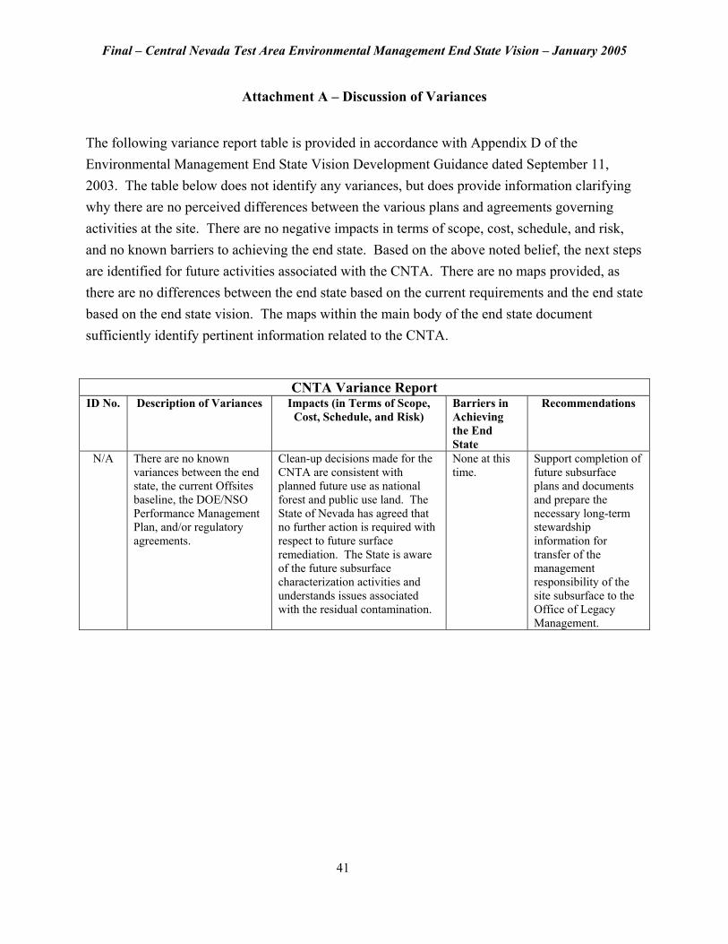
Attachment A – Discussion of Variances
The following variance report table is provided in accordance with Appendix D of the Environmental Management End State Vision Development Guidance dated September 11, 2003. The table below does not identify any variances, but does provide information clarifying why there are no perceived differences between the various plans and agreements governing activities at the site. There are no negative impacts in terms of scope, cost, schedule, and risk, and no known barriers to achieving the end state. Based on the above noted belief, the next steps are identified for future activities associated with the CNTA. There are no maps provided, as there are no differences between the end state based on the current requirements and the end state based on the end state vision. The maps within the main body of the end state document sufficiently identify pertinent information related to the CNTA.
CNTA Variance Report ID No. Description of Variances Impacts (in Terms of Scope,
Cost, Schedule, and Risk) Barriers in Achieving the End State
Recommendations
N/A There are no known variances between the end state, the current Offsites baseline, the DOE/NSO Performance Management Plan, and/or regulatory agreements.
Clean-up decisions made for the CNTA are consistent with planned future use as national forest and public use land. The State of Nevada has agreed that no further action is required with respect to future surface remediation. The State is aware of the future subsurface characterization activities and understands issues associated with the residual contamination.
None at this time.
Support completion of future subsurface plans and documents and prepare the necessary long-term stewardship information for transfer of the management responsibility of the site subsurface to the Office of Legacy Management.
41